HAL Id: halshs-01841272
https://halshs.archives-ouvertes.fr/halshs-01841272
Submitted on 17 Jul 2018HAL is a multi-disciplinary open access
archive for the deposit and dissemination of sci-entific research documents, whether they are pub-lished or not. The documents may come from teaching and research institutions in France or abroad, or from public or private research centers.
L’archive ouverte pluridisciplinaire HAL, est destinée au dépôt et à la diffusion de documents scientifiques de niveau recherche, publiés ou non, émanant des établissements d’enseignement et de recherche français ou étrangers, des laboratoires publics ou privés.
Initial spatial conditions in simulation models: the
missing leg of sensitivity analyses?
Clémentine Cottineau, Juste Raimbault, Marion Le Texier, Florent Le Néchet,
Romain Reuillon
To cite this version:
Clémentine Cottineau, Juste Raimbault, Marion Le Texier, Florent Le Néchet, Romain Reuillon. Ini-tial spaIni-tial conditions in simulation models: the missing leg of sensitivity analyses?. 2017 International Conference on GeoComputation: Celebrating 21 Years of GeoComputation, Sep 2017, Leeds, United Kingdom. �halshs-01841272�
Initial spatial conditions in simulation models: the missing
leg of sensitivity analyses?
Cl´ementine Cottineau∗1, Juste Raimbault2,4, Marion Le Texier3, Florent Le N´echet4, and Romain Reuillon2,5
1Centre for Advanced Spatial Analysis, University College London, UK 2
UMR 8504 G´eographie-cit´es, Paris, France
3
UMR 6266 IDEES, Universit´e de Rouen, France
4
Laboratoire Ville Mobilit´e Transport, Universit´e Paris-Est, France
5
Institut des Syst`emes Complexes Paris Ile-de-France, France
*
Email: [email protected]
Abstract
Although simulation models of geographical systems in general and agent-based models in par-ticular represent a fantastic opportunity to explore socio-spatial behaviours and to test a variety of scenarios for public policy, the validity of generative models is uncertain until their results are proven robust. Sensitivity analysis usually include the analysis of the effect of stochasticity on the variability of results, as well as the effects of small parameter changes. However, initial spatial conditions are usually taken for granted in geographical models, thus leaving completely unexplored the effect of spatial arrangements on the interaction of agents and of their interac-tions with the environment. In this contribution, we present a method to assess the effect of initial spatial conditions on simulation models, using a systematic generator controlled by meta-parameter to create density grids used in spatial simulation models. We show, with the example of two very classical agent-based models (Schelling’s models of segregation and Sugarscape) that the effect of space in simulation is significant, and sometimes even larger than parameters themselves. We do so using high performance computing in a very simple and straightforward open-source workflow.
Keywords: Space, Initial conditions, Sensitivity, ABM.
1
Introduction
Simulation has been recognised and increasingly used by geographers to explore various geographical processes and problems within virtual laboratories. It appears as a very fruitful way to overcome the difficulty of analytic resolution of many spatial models developed in the past, and to explore the possible trajectories of social and ecological systems in space and time. The specificity of geographical models compared with models from other social sciences is usually regarded as the way geographers consider space and spatial interactions, driven by an explicit interest in the way space influences the outcomes of the model. Geographers are indeed concerned about understanding and modelling how space plays a role in social interactions and environmental processes, and whether
its action is placed-based or place-neutral. We think simulation can become a very good tool to achieve this, provided that models include relevant spatial description and modelling, behavioural rules that take space into account, and provided model evaluation stresses the sensitivity of output variations to the way space is modelled. This communication focuses on a way to do so: by using a sensitivity method to test the model’s outcomes to initial spatial conditions.
2
Why spatial patterns are expected to impact social simulations
2.1 Because actual cities are not regular grids
Although this may seem obvious, cities are not regular grids of isotropic densities. Modelling may be about abstracting features to highlight processes in a way which is simpler than reality. However, the uniform grid which represents space in most simulation models is potentially not enough to represent urban processes because density and accessibility have environmental, economic and social consequences. An intermediate and more meaningful way of abstracting space might thus be to consider, not the peculiarities of every city, but their broad density structures. In Europe for example, one can find broad types of density distributions (Le N´echet (2015)). At initialisation, we then expect agents to be distributed in different patterns, which influence results in the long run. A first approach could be to evaluate the effects of the same set of social mechanisms, but modelled in different types of cities, for example monocentric, polycentric and discontinuous.
2.2 Because actual agents are not random walkers
We expect spatial patterns to influence model outcomes also because the agents’ rule of action itself might depend on the spatial structure of the environment. Indeed, mechanisms of surrounding sensing will be impacted by different distributions of density. For example, agents tend to create buffer zones if they are allowed network-based rather than isotropic movements (Banos (2012)), while the vision / sensing mechanism is sensitive to the scale of modelled environments (Laurie and Jaggi (2003); Fossett and Dietrich (2009)). Finally, households can have different preferences with respect to the built-environment (Spielman and Harrison (2014)), thus creating a sensitivity to the initial form of the city modelled.
3
Method
In this paper, we suggest tackling sensitivity to spatial conditions by generating a variety of density grids to feed into simulation models at initialisation, and exploring the sensitivity of the model outcomes to the variation of meta-parameters (i.e. parameters used to generate initial spatial conditions). The purpose is two-fold: 1/ to test the robustness of simulation results to small variations of meta-parameters within a typical category of space (a monocentric case for example) and 2/ to study the non-trivial effects of typical categories of spatial distribution (monocentric vs. polycentric for example) on the results of a given model (cf. figure 1).
Figure 1: General workflow of our method
3.1 Constructing a spatial generator
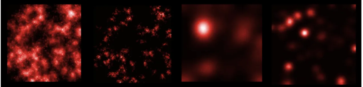
Our spatial generator applies an urban morphogenesis model (Batty (2007)), which has been gener-alised, explored and calibrated (Raimbault et al. (2014)). In a nutshell, grids are generated through an iterative process which adds a quantity N (population) at each time step, allocating it through preferential attachment characterised by its strength of attraction α. This first growth process is then smoothed n times using a diffusion process of strength β. Grids are thus generated from the combination of the values of these four meta-parameters α, β, n and N , in addition to the random seed. To ease our exploration, only the distribution of density is allowed to vary rather than the size of the grid, which we fix to a 50x50 square environment of 100,000 units (cf. figure 2).
Figure 2: Four examples of grids produced by the spatial generator
3.2 Including a (typical) variety of initial conditions in the sensitivity analysis
In order to generate density grids which correspond to empirical density distributions, we select among the generated grids using an objective function which matches the point cloud of 110 metropolitan areas in Europe described by four dimensions: their concentration index, hierarchy index, centrality index and continuity index (cf. Le N´echet (2015)). A stochastic exploration of a Latin Hypercube Sampling of 2000 points in the 4-dimensional space of parameters α, β, n, N gives a subset of 170 interesting grids matching empirical densities, which constituted our set of different initial spatial conditions. These are further clustered into three classes of morphology: compact
4
Application cases
We use our set of initial density grids in two spatial simulation models: Schelling and Sugarscape.
4.1 Schelling’s model of residential segregation
Schelling’s model consists in a abstract urban housing market where agents of different nature sense their environment, evaluate their satisfaction in terms of neighbourhood composition, and relocate if unsatisfied. It has been shown by Schelling (1969) that even tolerant agents tended to produce segregated patterns because of the complexity of their local interactions. The main parameters of this model are the tolerance level (% of agents similar to ego), the scope of sensing and the percentage of vacant spaces in the housing market. In addition, we are interested in testing the impact of the spatial distribution of housing capacity in this project, using the generated grids.
4.2 Sugarscape model of resource extraction and population settlement
Sugarscape is a model of resource extraction which simulates the unequal distribution of wealth within a heterogenous population (Epstein and Axtell (1996)). Agents of different vision scopes and different metabolisms harvest a self-regenerating resource available heterogeneously in the initial landscape, they settle and collect this resource, which leads some of them to survive and others to perish. The main parameters of this model are the number of agents, their minimal and maximal resource. In addition, we are interested in testing the impact of the spatial distribution of the resource in this project, using the generated grids. The outcome of the model is measured as a phase diagram of an index of inequality for ressource distribution (Gini index).
5
Results
We proceed to 4,500,000 simulation runs of the Schelling model (1000 parameter combinations x 45 density grids x 100 replications), using OpenMOLE to distribute the computation, and apply segregation measures to characterise the results. We find that the different urban morphologies impact the parameter interaction patterns, and that polycentric and discontinuous cities appear systematically more segregated than compact cities in terms of dissimilarity and entropy index. For Sugarscape, 2,500,000 simulations (1000 parameter points x 50 density grids x 50 replications) allow us to show that the model is more sensitive to space than to its other parameters, both qualitatively and quantitatively: the amplitude of variations across density grids is larger than the amplitude in each phase diagram, and the behavior of phase diagram is qualitatively different in different regions of the morphological space.
6
Acknowledgements
7
References
Banos, A.
2012. Network effects in Schelling’s model of segregation: new evidences from agent-based simula-tion. Environment and Planning B: Planning and Design, 39(2):393–405. 00007.
Batty, M.
2007. Cities and complexity: understanding cities with cellular automata, agent-based models, and fractals. The MIT press.
Epstein, J. M. and R. L. Axtell
1996. Growing artificial societies: Social science from the bottom up (complex adaptive systems). Brookings Institution Press MIT Press.
Fossett, M. and D. R. Dietrich
2009. Effects of city size, shape, and form, and neighborhood size and shape in agent-based models of residential segregation: are Schelling-style preference effects robust? Environment and Planning B: Planning and Design, 36(1):149–169. 00026.
Laurie, A. J. and N. K. Jaggi
2003. Role of’vision’in neighbourhood racial segregation: a variant of the Schelling segregation model. Urban Studies, 40(13):2687–2704. 00115.
Le N´echet, F.
2015. De la forme urbaine `a la structure m´etropolitaine: une typologie de la configuration interne des densit´es pour les principales m´eropoles europ´eennes de l’Audit Urbain. Cybergeo: European Journal of Geography.
Raimbault, J., A. Banos, and R. Doursat
2014. A hybrid network/grid model of urban morphogenesis and optimization. In 4th International Conference on Complex Systems and Applications (ICCSA 2014), Pp. 51–60. M. A. Aziz-Alaoui, C. Bertelle, X. Z. Liu, D. Olivier.
Schelling, T. C.
1969. Models of segregation. The American Economic Review, 59(2):488–493. Spielman, S. and P. Harrison
2014. The Co-evolution of Residential Segregation and the Built Environment at the Turn of the 20th Century: A Schelling Model. Transactions in GIS, 18(1):25–45.