HAL Id: tel-00010316
https://tel.archives-ouvertes.fr/tel-00010316
Submitted on 28 Sep 2005HAL is a multi-disciplinary open access archive for the deposit and dissemination of sci-entific research documents, whether they are pub-lished or not. The documents may come from teaching and research institutions in France or abroad, or from public or private research centers.
L’archive ouverte pluridisciplinaire HAL, est destinée au dépôt et à la diffusion de documents scientifiques de niveau recherche, publiés ou non, émanant des établissements d’enseignement et de recherche français ou étrangers, des laboratoires publics ou privés.
numerical modelling and data constraints
Pieter van der Beek
To cite this version:
Pieter van der Beek. Long term denudation rates and relief development: numerical modelling and data constraints. Geomorphology. Université Joseph-Fourier - Grenoble I, 2003. �tel-00010316�
M
EMOIREPrésenté par
Pieter Albert
VAN DER
B
EEK
Pour obtenir l’Habilitation à Diriger des Recherches
de l’Université Joseph Fourier – Grenoble I
Spécialité : Sciences de la Planète
L’
EROSION A LONG TERME ET L
’
EVOLUTION DU RELIEF
CONTINENTAL
:
MODELISATIONS NUMERIQUES ET DONNEES
CONTRAIGNANTES
Soutenu le 1 décembre 2003 à l’Université Joseph Fourier
Devant le jury composé de :
Pr. Mark B
RANDON(Yale
University) Rapporteur
Dr. Philippe D
AVY(CNRS – Géosciences Rennes)
Rapporteur
Dr. Christian F
RANCE-L
ANORD(CNRS – CRPG Nancy)
Examinateur
Pr. Joseph MARTINOD (LMTG – UPS Toulouse)
Invité
Pr. Peter M
OLNAR(University of Colorado)
Rapporteur
Ce dossier d’habilitation à diriger des recherches dresse un bilan de mon activité de recherche effectuée depuis l’obtention de ma thèse de doctorat, d’abord au Research School of Earth Sciences de l’Australian National University (1995-1997) et depuis 1998 au Laboratoire de Géodynamique des Chaînes Alpines de l’Université Joseph Fourier. Il présente également le projet scientifique que j’envisage de poursuivre dans les années à venir.
Je présente dans la première partie mon Curriculum Vitae avec un bilan succinct des thèmes de recherche que j’ai développés, mon activité d’encadrement de jeunes chercheurs et d’enseignement, ainsi qu’une liste de mes publications et conférences.
La deuxième partie propose quelques éléments de réflexion sur les relations entre tectonique, érosion et l’évolution du relief à long terme. Après une introduction générale, je dresse le bilan de ma contribution sur ce terrain, en ce qui concerne le développement et l’utilisation de modèles numériques des processus de surface pour étudier l’évolution du relief, ainsi que dans l’acquisition de données thermochronologiques pour contraindre les taux de dénudation.
La troisième et dernière partie de ce mémoire présente mon projet de recherche, axé sur le développement des modèles numériques des processus de surface et la mise en œuvre de nouvelles bases de données permettant d’appréhender l’évolution du relief. Afin de permettre une plus grande accessibilité pour tous les membres du jury d’habilitation, les deuxième et troisième parties de ce dossier seront rédigées en anglais.
O
UTLINEThis report contains a review of my research activities since obtaining my Ph.D. degree, first at the Research School of Earth Sciences of the Australian National University (1995-1997), and since 1998 at the Laboratoire de Géodynamique des Chaînes Alpines of the Université Joseph Fourier in Grenoble, France. It also presents the research perspectives I would like to develop in the coming years.
In the first part of this report I present my Curriculum Vitae and concisely introduce the research themes I have developed over the last years, as well as my activities in advising research students and teaching. This part, written in French, also contains a list of publications and seminars.
The second part contains a review of the relationships between tectonics, erosion, and long-term relief development. After a general introduction, I summarize my personal contribution to this research area, which concerns both the development and use of numerical surface process models to study relief development, and using thermochronological data in order to constrain rates of denudation and relief change.
Finally, in the third part of this report I outline my research perspectives for the coming years, which revolve around the further development and testing of numerical surface process models as well as developing new thermochronological databases that better permit to constrain relief development.
CURRICULUM VITAE 1
Formation 1
Expérience professionnelle 1
Thèmes de recherche développés 2
Encadrement de thèses 3
Encadrement de DEA 4
Encadrement de stages de maîtrise 5
Activités d'enseignement 6
Principales responsabilités collectives 6
Activités internationales (conférences invitées, contrats, séjours a l'étranger) 7
Projets de recherche attribués 7
Collaborations nationales et internationales 8
TRAVEAUX, PUBLICATIONS, COMMUNICATIONS 9
Revues internationales avec comité de lecture 9
Publications sous presse ou soumises 11
Contributions aux congrès internationaux 11
Contributions aux congrès nationaux 13
Rapports Internes, Documentation de logiciels, vulgarisation 13
Liste de Conférences 14
1. SCIENTIFIC CONTEXT:WHY STUDY RELIEF DEVELOPMENT, AND HOW? 17
1.1. Links between tectonics, climate and erosion 19
1.2. Numerical Surface Process Models 22
1.3. Constraining long-term rates of landscape development 29
1.4. Conclusions 34
2. CALIBRATING AND TESTING SURFACE PROCESS MODELS 35
2.1. General calibration of SPM parameters 35
2.2. Testing fluvial incision models: An example from SE Australia 37 2.3. A conceptual model for river incision based on observations in western Alpine rivers 39
INTERACTIONS 44 3.1. Post-break-up landscape development at rifted continental margins 44 3.2. Controls on drainage development at active mountain fronts: the Himalayas of central
Nepal 48
3.3. Toward coupled tectonics – surface process models of active mountain fronts 50
3.4. Conclusions 54
4. THERMOCHRONOLOGICAL DATA AS RECORDS OF DENUDATION RATES AND RELIEF
DEVELOPMENT 55
4.1. What do thermochronological data tell us about the morphologic development of rifted
continental margins? 55
4.2. Quaternary relief development in the western Alps 57
4.3. Temporal evolution of denudation rates in the Nepal Himalaya: detrital thermo-
chronology of Siwalik deposits. 62
4.4. Conclusions 66
5. OUTLOOK AND RESEARCH PERSPECTIVES 68
5.1. Toward a general model for fluvial incision 68
5.2. Glacial erosion, denudation rates, and relief development 70 5.3. New thermochronological databases and interpretative tools 72
REFERENCES 75
P
IETERA.
VAN DERB
EEKMaître de Conférences
Laboratoire de Géodynamique des Chaînes Alpines – UMR 5025 CNRS Observatoire des Sciences de l’Univers de Grenoble
Université Joseph Fourier
BP 53 38041 Grenoble Cedex Tél : 04 76 51 40 62 Fax : 04 76 51 40 58 e-mail: [email protected] DONNEES PERSONNELLES: Né le 24/05/1967 à Voorburg (Pays-Bas) Vie maritale (1 enfant)
Nationalité Néerlandaise
FORMATION:
1985-1990: Master en Sciences de la Terre, Vrije Universiteit, Amsterdam. Sujets principaux: géologie structurale et tectonique.
Sujets secondaires: analyse des bassins sédimentaires, géologie sédimentaire, tectonophysique (à l'Université d'Utrecht), pétrologie.
1991-1995 Doctorat en Sciences de la Terre, Vrije Universiteit, Amsterdam.
Thèse ayant pour titre: 'Tectonic evolution of continental rifts: Inferences from numerical modelling and fission-track thermochronology', soutenue le 24 Mai 1995. Directeurs de thèse: Prof. Sierd Cloetingh, Dr. Paul Andriessen.
EXPERIENCE PROFESSIONNELLE :
1991-1995 Assistant en Formation, Vrije Universiteit Amsterdam, Pays-Bas.
1995-1997 Chercheur Post-doctoral, Research School of Earth Sciences, Australian National University, Canberra, Australie.
1998- Maître de conférences, Université Joseph Fourier, Grenoble. 1999- Attribution de la prime d’encadrement doctoral et de recherche. 2001-2002 Délégation auprès du CNRS.
THEMES DE RECHERCHE DEVELOPPES :
Mes activités de recherche depuis ma thèse se sont concentrées principalement sur l’interaction entre processus tectoniques et processus érosifs dans l’évolution du relief. J’aborde cette question d’une part par le développement et l’utilisation de modèles numériques de processus de surface, d’autre part en récoltant des données qui permettent de contraindre les taux d’érosion et de dénudation des reliefs, permettant ainsi également de tester et de valider les modèles.
J’ai utilisé un modèle de processus de surface afin d’étudier l’évolution morphologique post-rift des marges passives (marge sud-est australienne et marge sud-africaine). Ces marges sont caractérisées par des escarpements majeurs dont l’origine, l’évolution et la signification restent controversées. Mes travaux, en collaboration avec J. Braun (ANU Canberra, Australie), M. Summerfield (Univ. Edimbourg, R.U.) et R.W. Brown (Univ. Melbourne, Australie) ont montré que ces escarpements ne résultent pas nécessairement d’une phase de soulèvement syn- ou post-rift et qu’ils se forment probablement très tôt dans l’histoire de la marge pour évoluer que très lentement depuis. Ces travaux, qui découlaient de mon séjour post-doctoral à l’ANU, ont résultés en 5 publications internationales ainsi qu’en deux conférences invités à des congrès. J’ai également utilisé le modèle pour étudier l’évolution des réseaux de drainage dans des régions tectoniquement actives, notamment dans la région frontale de l’Himalaya. Ce travail a été entamé dans le cadre du DEA de Bénédicte Champel-Duffait et se poursuit lors de sa thèse.
Bien que les modèles numériques de processus de surface soient très utiles pour étudier l’évolution du relief à long terme, ils restent à perfectionner. Ceci est particulièrement vrai en ce qui concerne la modélisation de l’érosion fluviale, qui est la composante à la fois la plus importante et la moins comprises de ces modèles. Pas moins que six algorithmes décrivant l’incision fluviale ont été proposés ces dernières années et il n’est pas clair à ce jour comment le mieux capter ce processus. J’ai utilisé, en collaboration avec P. Bishop (Univ. Glasgow, R.U.), un « laboratoire naturel », où l’on peut contraindre en détail l’évolution du profil en long d’une rivière dans le temps, pour tester ces modèles. Des coulées de lave se sont déversés dans la vallée du Lachlan (SE Australie) et de ces affluents il y a 21 Ma et ont fossilisées ces paléo-vallées ; la rivière ayant incisé le bedrock au bord des coulées, cette situation nous permet de reconstruire l’incision de la rivière et de ces affluents. Nous avons ainsi pu tester si les différents modèles permettent de prédire le profil actuel à partir des conditions de départ connus. J’ai également travaillé dans le cadre de la thèse de Gilles Brocard sur les rivières ouest alpines qui montrent une variation importante dans leur degré de perturbation glaciaire. Nous avons contraint les taux d’incision de ces rivières par des datations cosmogéniques des terrasses qui les bordent, et nous avons construit une base de données importante qui a permis de proposer un modèle conceptuel pour l’incision fluviale.
En ce qui concerne l’acquisition de données permettant de quantifier les taux d’érosion à long terme, j’ai commencé, également dans le cadre de la thèse de Gilles Brocard et en collaboration avec D. Bourlès (CEREGE), à utiliser l’isotope cosmogénique 10Be pour dater des terrasses fluviales et ainsi
quantifier les taux d’incision des rivières, dans les Alpes et le Zagros iranien. Je me suis investi fortement dans l’acquisition de données thermochronologiques par traces de fission, en prenant la responsabilité du laboratoire de traces de fission au sein du LGCA au départ de son ancien
responsable G. Poupeau. La modernisation de ce laboratoire et sa mise en conformité avec les exigences internationales dans ce domaine (utilisation de détecteurs, de moniteurs de fluence et de standards prescrits) ont demandé un investissement important pour lequel j’ai demandé et obtenu une année de délégation au CNRS (2001-2002). J’utilise actuellement des données thermochronologiques par traces de fission dans le cadre de deux projets. J’étudie l’évolution récente du relief des Massif Cristallins Externes des Alpes occidentales et le contrôle des glaciations quaternaires sur cette évolution, en récoltant de nouvelles données thermochronologiques dans ces massifs et en les analysant par l’utilisation de nouvelles méthodes quantitatives mises au point par J. Braun (ANU, Canberra). Nous avons également (avec R. Pik, P. Huyghe, J.L. Mugnier et J. Lavé) lancé un projet de thermochronologie détritique sur les sédiments molassiques de l’Himalaya (les Siwaliks du Népal central et occidental) afin de reconstruire les taux de dénudation de l’Himalaya pendant les dernier 15 millions d’années et d’élucider les contrôles tectoniques et climatiques sur l’évolution de ces taux.
ENCADREMENT DE THESES :
1998-2002 :GillesBROCARD (co-encadré à 90 % avec J.L. Mugnier, LGCA)
Titre: Origine, variabilité spatio-temporelle et signature morphologique de l’incision fluviale dans les Alpes dauphinoises (SE France).
Financement : bourse MER Thèse soutenue le 03/06/2002
Situation actuelle du diplômé : ATER à l’Université de Rouen
Ce travail de thèse s’est concentré sur la signature morphologique et les processus de l’incision fluviale dans les alpes externes occidentales. Dans cette région, des rivières comme la Drôme ou le Buëch, dont le bassin versant n’a pas été englacé pendant la dernière glaciation, enregistrent un taux d’incision constant de ~0.8 mm/an sur les derniers 200 Ka (démontré par des datations cosmogéniques des terrasses fluviales le long du Buëch) et semblent évoluer en état stationnaire. En revanche, l’incision d’une rivière comme le Drac, qui a été obturé par le glacier de l’Isère, est contrôlé par le retour à l’équilibre d’un profil fortement perturbé et peut atteindre des taux de plusieurs cm/an. Une comparaison des variables hydrodynamiques (déclivité, largeur, largeur de la plaine alluviale) en fonction de l’aire drainée et de la lithologie le long de ces rivières et de leurs affluents a permis d’établir un modèle conceptuel pour le comportement de ces rivières, qui est en accord avec des modèles théoriques récemment élaborés. Un premier article sur ce travail vient d’apparaître, trois autres sont soumis.
2000-2004 : Bénédicte CHAMPEL-DUFFAIT (co-encadré à 75% avec J.L. Mugnier et A. Pêcher, LGCA)
Titre : Evolution tectonique contrasté le long de la chaîne himalayenne : un effet climatique ? Apport d’une étude de modélisation numérique.
Financement : Bourse Ecole Polytechnique
Thèse en cours (l’étudiante à bénéficiée d’un congé de maternité)
Cette thèse a pour but de comprendre les variations morphologiques et structurales observés le long du front himalayen, en termes de contrôles tectoniques et climatiques. On observe notamment des variations importantes dans la structure du prisme d’accrétion des Siwaliks, ainsi que dans la morphologie du front de chaîne. Le travail de thèse de Bénédicte a consisté dans un premier temps en la terminaison et valorisation de son travail de DEA (voir plus loin), ce qui a mené à deux publications internationales et plusieurs interventions à des congrès. Ensuite, elle s’est investie dans la réalisation d’un
modèle décrivant l’évolution du prisme de Siwaliks, dans lequel les processus de surface sont couplés à la tectonique par le biais d’un modèle de « moindre travail ». Ce modèle permettra d’étudier le contrôle de paramètres internes (rhéologie du prisme, friction sur le décollement de base) et externes (paramètres érosives) sur le développement structural du prisme et la séquence d’activation des chevauchements. En même temps, Bénédicte a travaillé sur un modèle réellement dynamique pour étudier l’évolution de toute la chaîne à plus long terme.
1998-2002 : Florence BIGOT-CORMIER (co-encadré à 10% avec M. Sosson, Géosciences Azur, et G. Poupeau, LGCA)
Titre : La surrection du massif cristallin externe de l’Argentera (France-Italie) et ses relations avec la déformation pliocène de la marge nord-ligure : Arguments thermochronologiques (traces de fission), géomorphologiques et interprétations de sismique marine.
Financement : bourse MER Thèse soutenue le 15/05/2002
Situation actuelle de la diplômée : recrutée comme Maître de Conférences à l’Université de Nice (2003)
J’ai supervisé les analyses et modélisations morphologiques du massif de l’Argentéra qui ont été effectués dans le cadre de ce travail.
2003- : Benham OVEISI (co-encadré à 40% avec J. Lavé, LGCA)
Titre : Soulèvement et incision de rivières dans le domaine plissé du Zagros (Iran). Financement : bourse MAE (l’étudiant est salarié du Geological Survey of Iran). Thèse en cours (débuté le 01/09/03)
La thèse de Benham Oveisi a pour but d’élucider les mouvements verticaux sur le moyen le long d’un transect dans la partie centrale du Zagros, à partir d’observations géomorphologiques. En effet, de multiples terrasses fluviales sont préservées le long de grandes rivières traversant le Zagros ainsi que des terrasses marines le long des plis frontaux. Ces terrasses seront cartographiées précisément (par GPS cinématique) et datées en utilisant des datations cosmogéniques pour les terrasses fluviales et 14C pour
les terrasses marines. Les vitesses d’incision et de soulèvement obtenues seront intégrées avec des données structurales afin d’arriver à un modèle de déformation de la chaîne, qui sera confronté aux données sismotectoniques et géodésiques précédemment récoltés sur la zone d’étude.
ENCADREMENT DE DEA :
1999 : Christian VERRARD : Modélisation numérique de l’érosion glaciaire.
Situation actuelle du diplômé : En thèse à l’Université de Munich (Allemagne)
1999 : Pierre-Yves VIOLLE : Relations entre la géomorphologie et la lithologie des trapps d'Ethiopie (co-encadré à 50 % avec N. Arndt, LGCA).
2000 : Bénédicte CHAMPEL-DUFFAIT : Modélisation de l’évolution morphologique d’un système chevauchant actif (co-encadré à 80% avec J.L. Mugnier, LGCA).
Situation actuelle de la diplômée : En thèse au LGCA
2000 : Elisabeth PEYSSON : Age et modalités de la formation du relief du massif du Pelvoux : Influences tectoniques et climatiques (co-encadré à 60% avec J. Lavé, LGCA).
Situation actuelle de la diplômée : DESS Application de l'Informatique aux Sciences de la Terre (Université de Marne-la-Vallée)
2002 : Christine AUTHEMAYOU: Géométrie tridimensionelle et tectonique de raccourcissement nord-sud dans le massif du Pelvoux (co-encadré à 30% avec Th. Dumont, LGCA).
Situation actuelle de la diplômée : En thèse au CEREGE
2002 : Stéphane HOMKE : Evolution métamorphique et structurale de la croûte continentale durant le rifting (exemple du rift Est Africain) (co-encadré à 30% avec V. Gardien, LST Lyon).
Situation actuelle du diplômé : En thèse à l’Institut Jaume Alméra, CSIC (Barcelone, Espagne)
2003 : Karen CHINI : Etude d'un système morphologique global à partir d'un modèle numérique de l'érosion : Application aux Transverse Ranges (Californie) (co-encadré à 50% avec J. Lavé, LGCA)
ENCADREMENT DE STAGES DE MAITRISE :
1997 : Anna PULFORD (BSc. Honours Geology, Australian National University) : Cenozoic landscape evolution of the East Australian Highlands: Constraints from Miocene Basalts, Blue Mountains, NSW.
1999 : Wouter BOS (Maîtrise Physique et Applications UJF) : Numerical modelling of the morphological evolution of a region of active folding.
1999: Jean-Daniel CHAMPAGNAC (Maîtrise STU UJF) : Etude morphostructurale du Plateau de Valensole (Alpes de Hautes Provence) (co-encadrants : Th. Dumont, P. Leturmy ; LGCA)
1999 : Arnaud VANDERBECQ (Maîtrise STU UJF) : Construction d’un Modèle Numérique de Terrain à partir d’images satellites SPOT (co-encadrant : G. Vidal ; LST Lyon)
1999 : Bénédicte DUFFAIT (Stage de 4ème année, Ecole Polytechnique) : Modélisation de
l’évolution morphologique d’un système chevauchant actif.
2002 : Sarah BUREAUS (Maîtrise STU UJF) : Morphologie tardi-glaciaire dans les collines de Belledonne, évaluation d’un volume d’érosion (co-encadrant : C. Basile ; LGCA)
2003 : Florence REVOL (Maîtrise Physique et Applications UJF) : Rivières en équilibre dynamique et en déséquilibre dans les Alpes occidentales : tests pour les modèles d’incision fluviatile.
2003 : Cédric DUPUIS (Magistère Physique et Applications UJF) : Levé gravimétrique de la vallée de Bourg d'Oisans et réalisation d'une carte gravimétrique (co-encadrants : P. Huyghe ; LGCA, M. Vallon ; LGGE).
A
CTIVITES D'E
NSEIGNEMENT:
1998- Enseignement de Sciences de la Terre dans l’UFR de Géologie (succédé par l’Observatoire des Sciences de l’univers) de l’Université Joseph Fourier :
DEUG SMb : Cours de géologie générale.
DEUG STU : Encadrement de stages de cartographie en terrain sédimentaire
Licence STUE (3ème année) : TP Cartographie, Cours/TD analyse structurale
(responsable de module), TD/TP géomorphologie, stages de terrain en tectonique. Maîtrise/Mastère 1 STUE : Cours/TD Cartographie et Télédétection (responsable de
module), Tectonophysique, Dynamique des Bassins Sédimentaires, stage de terrain de fin d’année (tectonique, sédimentation).
CAPES/Aggrégation Sciences Naturelles : Leçons et TD (Relief de la Terre, Dynamique des Bassins, Tectonique et Climat)
DEA Dynamique de la Lithosphère/Mastère 2 Recherche STUE : Cours et séminaires (thermochronologie, structure thermique de la croûte, interaction tectonique-climat-érosion, modélisation des processus de surface, datations cosmogéniques)
1997 Intervention dans le cadre d’un cours de 3ème cycle (graduate course) à la Research School of Earth Sciences, Australian National University.
1991-1995 Assistant en Formation au Vrije Universiteit Amsterdam (équivalent monitorat) : Encadrement du stage de cartographie des étudiants de premier cycle (3 semaines par
an, sud de l'Espagne).
TP/TD d'analyse quantitative de bassins sédimentaires pour des étudiants de 2ème cycle
("backstripping", modèles d'extension, flexure).
PRINCIPALES RESPONSABILITES COLLECTIVES :
· Membre du Conseil de Laboratoire du LGCA. (1999 - 2003), de la Commission de Spécialistes (Section 35-36-37) de l’Université Joseph Fourier (2000 - ) et de la Commission Outils Communs de l’Observatoire des Sciences de l’Univers de Grenoble (2000 -).
· Responsable informatique au sein du LGCA (1998-2000)
· Responsable du laboratoire de thermochronologie par traces de fission au LGCA (2000 -). · Responsable pédagogique des modules « Outils Géologiques » (Licence STUE 3ème année,
1999-), « Cartographie et Télédétection » (Mastère STUE 1ère année, 2000 -) et « Quantification des déformations de la lithosphère » (Mastère STUE Recherche 2ème année, 2003 -).
· Rapporteur pour 3 Thèses (Ph.D) à l’Université de Monash (Melbourne, Australie, 1999), l’Université de Gothenborg (Suède, 2001), et l’Université de Glasgow (Royaume-Uni, 2003) et pour un mémoire de MSc. à l’Université de Dalhousie (Halifax, Canada, 2000)
· “Reviewer” de nombreuses articles soumises à différentes revues internationales (Journal of
Geophysical Research, Tectonics, Tectonophysics, Basin Research, Earth and Planetary Science Letters, Terra Nova, Global and Planetary Change) (1998-).
· “Convener” de sessions scientifiques à l’11ème Congrès de l’EUG (Strasbourg, France, Avril
ACTIVITES INTERNATIONALES (CONFERENCES INVITEES,CONTRATS,SEJOURS A
L'ETRANGER):
Septembre 1995 : Instructeur d'un cours de Norsk Hydro/SAGA Petroleum: "Tectonics of Continental Rifts" à Oslo.
Octobre 1996 : Mission de terrain en Papouasie-Nouvelle-Guinée dans le cadre d’une campagne d’acquisition de données GPS, suivi d’une étude de faisabilité d’un projet sur la tectonique active de la Chaîne de Finisterre.
Février 2000 : Conférence invitée au “ 9th International Congres on Fission Track Dating and
Thermochronology ”, Lorne (Australie).
Avril 2000 ; Juin 2001 ; 2002 ; 2003 : Collaboration à un Cours Intensif Européen (Socrates) annuel sur « Sedimentation and Tectonics in Compressive Settings » à Barcelone et Grenoble.
Décembre 2000 : Conférence invitée au “Gilbert Club”, réunion annuelle de géomorphologues américains, Berkeley, EU.
Juin 2001 : Conférence invitée à la réunion du groupe “Earth System Processes and Evolution” du “Canadian Insitute of Advanced Research”, Edimbourg, R.U.
Septembre-Octobre 2001 : visite en Iran, sur invitation du Service Géologique de l’Iran, pour étudier la faisabilité d’un projet de recherche commun sur la néotectonique de la Chaîne du Zagros, participation au 1er “France-Iranian Workshop on geodynamics and seismic risk”.
Février 2002 : Instructeur d’un « Short Course » sur la géomorphologie quantitative au Vrije Universiteit Amsterdam (Pays-Bas)
Janvier 2003 : Participant invité au Penrose Conference de la Société Géologique américaine sur « Climate, Tectonics and Landscape Evolution », Parc National de Taroko, Taiwan ; combiné avec une mission au Népal.
Séminaires invités aux Universités de Melbourne (Australie), Sydney (Australie), Edimbourg (R.U.), Cambridge (R.U.), Rennes, Dalhousie (Canada), Tübingen (Allemagne), Nice et Londres (R.U.) (depuis 1996).
PROJETS DE RECHERCHE ATTRIBUES :
Comme Responsable
1999-2001 : Action Thématique Innovante (CNRS) « Soulèvement et dénudation récents des massifs cristallins externes des Alpes occidentales : modalités et quantification » 156 KF demandé, 100 KF obtenu (avec P. Huyghe, J. Lavé, F. Jouanne).
1999-2001 : Action Intégré franco-britannique « Alliance » (MAE / British Council) « Evaluation de modèles de processus de surface à partir d’un laboratoire naturel » (avec P. Bishop, University of Glasgow), 3 visites réciproques attribués.
2000-2002 : Programme Intérieur de la Terre (INSU-CNRS) « Interaction Processus Internes – Processus Externes dans l’Evolution récente de l’Himalaya (Nepal) : Archives Thermochronologiques et Modélisation » 136 KF + 30 K€ demandé, 115 KF + 25 K€ obtenu (avec J. Lavé, R. Pik, J.L. Mugnier, C. France-Lanord, P. Huyghe).
2002 : Demande de Moyens - Equipement mi-lourd (INSU-CNRS) « Etablissement d’un système de thermochronologie par traces de fission automatisé » 10,6 K€ demandé, 10 K€ obtenu.
2003-2005 : Bourse Postdoctorale Marie-Curie (Commission Européenne) « Quantification of long-term exhumation in active mountain belts through detrital fission-track analysis »
demandé pour M. Bernet, au total 125 K€ attribué.
Comme participant
1998-2000 : Programme National de Recherche Sols et Erosion (INSU-CNRS) « Développement et Dynamique des systèmes fluviatiles », responsable J. Van Den Driessche (Géosciences Rennes), 260 KF demandé, 160 KF obtenu.
2001-2003 : Programme Intérieur de la Terre (INSU-CNRS) « Mouvements verticaux à différentes échelles de temps dans le domaine plissé du Zagros », responsable J. Lavé (partie du projet « Dynamique Actuelle de l’Iran » resp. D. Hatzfeld), 90 KF demandé et obtenu. 2002-2003 : Pôle Grenoblois des Risques Naturels (Région Rhône Alpes – UJF) « Quantification de
l’érosion tardi-glaciaire dans les collines de Belledonne, Isère », responsable C. Basile, 10 K€ demandé et obtenu.
COLLABORATIONS NATIONALES ET INTERNATIONALES :
Paul Bishop (University of Glasgow, R.U.) : Tester des modèles numériques d’incision fluviales à
partir de la reconstruction de profils en long des rivières.
Didier Bourlès (CEREGE, Université d’Aix-Marseille III) : Datations cosmogéniques pour
contraindre les taux d’incision et d’érosion.
Jean Braun (Australian National University, Canberra, Australie) : Développement des méthodes
numériques pour contraindre et simuler l’évolution du relief.
Raphaël Pik (CRPG, Nancy) : Mise au point de méthodes d’analyse thermochronologiques
détritiques multi-méthodes (Traces de fission, (U-Th)/He, U-Pb).
Hugh Sinclair (University of Edinburgh, R.U.) : Evolution récente du relief alpin ; contrôles sur le
développement des réseaux de drainage en Himalaya ; message sédimentaire des avant-pays alpins et himalayens.
Michael Summerfield (University of Edinburgh, R.U.): Evolution à long terme du relief sur les
T
RAVAUX,
PUBLICATIONS,
COMMUNICATIONSRevues internationales avec comité de lecture
1. van der Beek, P.A. & Cloetingh, S., Lithospheric flexure and the tectonic evolution of the Betic Cordilleras (SE Spain). Tectonophysics, 203, 325-344, 1992.
2. Cloetingh, S., van der Beek, P.A., van Rees, D., Roep, Th. B., Biermann, C. & Stephenson, R.A., Flexural interaction and the dynamics of Neogene extensional basin formation in the Alboran-Betic region. Geo-Marine Letters, 12, 66-75, 1992.
3. Jelsma, H.A., van der Beek, P.A. & Vinyu, M.L., Tectonic evolution of the Bindura-Shamva greenstone belt (northern Zimbabwe): progressive deformation around diapiric batholiths. Journal of Structural Geology, 15, 163-176, 1993.
4. Stel, H., Cloetingh, S., Heeremans, M.M.H. & van der Beek, P.A., Anorogenic granites, magmatic underplating and the origin of intracratonic basins in a non-extensional setting.
Tectonophysics, 226, 285-299, 1993.
5. van der Beek, P.A., Cloetingh, S. & Andriessen, P.A.M., Mechanisms of extensional basin formation and vertical motions at rift flanks: Constraints from tectonic modelling and fission-track thermochronology. Earth and Planetary Science Letters, 121, 417-433, 1994.
6. Pedersen, T. & van der Beek, P.A., Extension and magmatism in the Oslo Rift, SE Norway: no sign of a mantle plume. Earth and Planetary Science Letters, 123, 317-330, 1994.
7. Rohrman, M., van der Beek, P.A. & Andriessen, P.A.M., Syn-rift thermal structure and post-rift evolution of the Oslo Rift (SE Norway): new constraints from fission-track thermochronology. Earth and Planetary Science Letters, 127, 39-54, 1994.
8. van der Beek, P.A., Andriessen, P.A.M. & Cloetingh, S., Morphotectonic evolution of rifted continental margins: Inferences from a coupled tectonic-surface processes model and fission track thermochronology. Tectonics, 14, 406-421, 1995.
9. Cloetingh, S., van Wees, J.D., van der Beek, P.A. & Spadini, G., Role of pre-rift rheology in kinematics of extensional basin formation: constraints from thermomechanical models of Mediterranean and intracratonic basins. Marine and Petroleum Geology, 12, 793-808, 1995.
10. Rohrman, M., van der Beek, P.A., Andriessen, P.A.M. & Cloetingh, S., Meso-Cenozoic morphotectonic evolution of southern Norway: Neogene domal uplift inferred from apatite fission-track thermochronology. Tectonics, 14, 704-718, 1995.
11. van Balen, R.T., van der Beek, P.A. & Cloetingh, S., The influence of rift shoulder erosion on stratal patterns at passive margins: Implications for sequence stratigraphy.
Earth and Planetary Science Letters, 134, 527-544, 1995.
12. van der Beek, P.A., Delvaux, D., Andriessen, P.A.M. & Levi, K.G., Early Cretaceous denudation related to compressional deformation in the Baikal region, SE Siberia.
Journal of the Geological Society London, 153, 515-523, 1996.
13. Heeremans, M., Stel, H., van der Beek, P.A. & Lankreijer, A.C., Tectono-magmatic control on vertical dip-slip basement faulting: an example from the Fennoscandian Shield. Terra Nova, 8, 129-140, 1996.
14. Rohrman, M. & van der Beek, P.A., Cenozoic post-rift domal uplift of North Atlantic margins; An asthenospheric diapirism model. Geology, 24, 901-904, 1996.
15. Rohrman, M. Andriessen, P.A.M. & van der Beek, P.A., The relationship between basin and margin thermal evolution assessed by fission-track thermochronology: An application to offshore southern Norway. Basin Research, 8, 45-63, 1996.
16. van der Beek, P.A., Flank uplift and topography at the central Baikal Rift (SE Siberia): A test of kinematic models for continental extension, Tectonics, 16, 122-136, 1997.
17. van der Beek, P.A. & Rohrman, M., Passive margin uplift around the North Atlantic region and its role in Northern Hemisphere late Cenozoic glaciation : Comment.
Geology, 25, 282, 1997.
18. van der Beek, P.A., Flank uplift and topography at the central Baikal Rift (SE Siberia): A test of kinematic models for continental extension (Reply to comment by A. Roberts and N. Kusznir), Tectonics, 17, 324-327,1998.
19. van der Beek, P.A., Mbede, E., Andriessen, P.A.M. & Delvaux, D., Denudation history of the Malawi and Rukwa Rift flanks (East African Rift System) from apatite fission track thermochronology, Journal of African Earth Sciences, 26, 363-385, 1998.
20. Pedersen, T., Heeremans, M. & van der Beek, P.A., Models of crustal anatexis in volcanic rifts: Application to S. Finland and the Oslo Graben, SE Norway, Geophysical
Journal International, 132, 239-255, 1998.
21. Poort, J., van der Beek, P.A., & ter Voorde, M., An integrated modelling study of the central and northern Baikal rift: Evidence for non-uniform lithospheric thinning?
Tectonophysics, 291, 101-122, 1998.
22. Tregoning, P., Lambeck, K., Stolz, A., Morgan, P.J., McClusky, S.C., van der Beek, P.A., McQueen, H., Jackson, R.J., Little, R.P., Laing, A. & Murphy, B., Determination of current plate motions in Papua New Guinea from Global Positioning System observations, Journal of Geophysical Research, 103, 12,181-12,203, 1998.
23. van der Beek, P.A. & Braun, J., Numerical modelling of landscape evolution on geological time-scales : a parameter analysis and comparison with the south-eastern highlands of Australia, Basin Research, 10, 49-68, 1998.
24. van der Beek, P.A. & Braun, J., Controls on Post-mid-Cretaceous landscape evolution in the Southeastern Highlands of Australia : Insights from numerical surface process models, Journal of Geophysical Research, 104, 4945-4966, 1999.
25. van der Beek, P.A., Braun, J. & Lambeck, K., The Post-Palaeozoic uplift history of south-eastern Australia revisited : Results from a process-based model of landscape evolution, Australian Journal of Earth Sciences, 46, 157-172, 1999.
26. Odinsen, T. Reemst, P. van der Beek, P.A., Faleide, J.I. and Gabrielsen, R.H., Permo-Triassic and Jurassic extension in the northern North Sea: results from tectono-stratigraphic forward modelling, in Dynamics of the Norwegian Margin (A. Nøttvedt, ed.), Geological Society Special Publication, 167, 83-103, 2000.
27. van der Beek, P.A., Pulford, A., & Braun, J. Cenozoic Landscape Development in the Blue Mountains (SE Australia): Lithological and Tectonic Controls on Rifted Margin Morphology, Journal of Geology,109, 35-56, 2001.
28. van der Beek, P.A., Champel, B., & Mugnier, J.L., Controls on drainage development in regions of active fault-propagation folding, Geology, 30, 471-474, 2002.
29. Champel, B., P.A. van der Beek, J.L. Mugnier & P. Leturmy, Uplift and lateral propagation of fault-related folds in the Siwalik foothills, Nepal Himalaya : Rates, mechanisms, and geomorphic signature, Journal of Geophysical Research, 107, 2111, doi: 10.1029/2001JB000578, 2002.
30. Rohrman, M., van der Beek, P.A., van der Hilst, R.D., & Reemst, P., Timing and mechanisms of North Atlantic Cenozoic Uplift: Evidence for mantle upwelling, in Doré, A.G., Cartwright, J.A., Stoker, M.S., Turner, J.P, & White, N (Eds.), Exhumation of the North Atlantic Margins: Timing, Mechanisms and Implications for Petroleum Exploration, Geological Society Special Publication, 196, 27-43, 2002.
31. van der Beek, P.A., Summerfield, M.A., Braun, J., Brown, R.W., & Fleming, A., Modelling post-break-up landscape evolution and denudation history across the eastern margin (Drakensberg Escarpment) of southern Africa, Journal of Geophysical Research,
107, 2351, doi: 10.1029/2001JB000744, 2002.
32. Brocard, G.Y., P.A. van der Beek, D.L. Bourlès, L.L. Siame, and J.-L. Mugnier, Long-term fluvial incision rates and postglacial river relaxation time in the French Western
Alps from 10Be dating of alluvial terraces with assessment of inheritance, soil development and wind ablation effects, Earth and Planetary Science Letters, 209, 197-214, 2003.
33. van der Beek, P.A., and P. Bishop, Cenozoic river profile development in the Upper Lachlan catchment (SE Australia) as a test of quantitative fluvial incision models,
Journal of Geophysical Research, 108, doi: 10.1029/2002JB002125, 2003.
Publications sous presse ou soumises
34. Brocard, G.Y., D.L. Bourlès, P.A. van der Beek and L.L. Siame, 10Be dating of some
major extents of the last glaciations in the French Alps, Quaternary Science Reviews,
sousmis, 2003.
35. Brocard, G.Y., and P.A. van der Beek, Influence of incision rate, rock strength and bedload supply on bedrock river gradients and valley-flat widths: Field-based evidence and calibrations from western Alpine rivers (SE France), in: Tectonics, Climate and
Landscape Evolution, Geol. Soc. Am. Spec. Publ. (S.D. Willett, N. Hovius, M.T.
Brandon and D. Fisher, eds.), sousmis, 2003.
36. Zarki-Jakni, B., P.A. van der Beek, G. Poupeau, M. Sosson, E. Labrin, Ph. Rossi, and J. Ferrandini, Cenozoic denudation of Corsica in response to Ligurian and Tyrrhenian extension : results from apatite fission-track thermochronology, Tectonics, sous presse, 2003.
Contributions aux congrès internationaux (comme premier auteur ou avec étudiants) 1. van der Beek, P.A. & Cloetingh, S., Constraints on lithosphere dynamics and the
tectonic evolution of the Betic Cordilleras from flexural and gravity analyses, EUG VI, 24-28 Mars 1991, Strasbourg, France (Terra abstracts, 3, 244).
2. van der Beek, P.A., Rohrman, M., Cloetingh, S. & Andriessen, P.A.M., Constraints on thermomechanical rifting models from apatite fission-track analysis: the Oslo rift, S. Norway, EGS XVII, 6-10 Avril 1992, Edinbourgh, R.U. (Ann. Geophys., 10, C..).
3. van der Beek, P.A., Rohrman, M., Cloetingh, S. & Andriessen, P.A.M., Constraints on thermomechanical rifting models from apatite fission-track analysis, 7th Int. Fission
Track Workshop, 13-17 Juillet 1992, Philadelphia, E.U.
4. van der Beek, P.A., van Balen, R.T., Cloetingh, S. & Andriessen, P.A.M., Uplift and exhumation of rift flanks, Constraints from tectonic modelling and fission-track data. EUG VII, 4-8 Avril 1993, Strasbourg, France, (Terra abstracts, 5, 157-158).
5. van der Beek, P.A., Pedersen, T. & Rohrman, M., Thermal and magmatic evolution of the Oslo Rift (SE Norway) from fission-track thermochronology and quantitative modelling. EGS XIX, 25-29 Avril 1994, Grenoble, France (Ann. Geophys., 12, C..). 6. van der Beek, P.A., Delvaux, D., Andriessen, P.A.M., van Wees, J.D., Levi, K.,
Cloetingh, S. & Klerkx, J., uplift of the Baikal rift flanks: An integrated fission track and tectonic modelling study, EUG VIII, 9-13 Avril 1995, Strasbourg, France (Terra
abstracts, 7, 44).
7. van der Beek, P.A. & Braun, J., Modelling the denudational history of the Southeastern highlands: Insights into the tectonic evolution of the eastern Australian margin. AGU Western Pacific Geophysics Meeting, 23-27 Juillet 196, Brisbane, Australie, (EOS, 77, W152).
8. van der Beek, P.A. & Braun, J., 1997. Modelling post-Cretaceous landscape evolution in the southeastern highlands of Australia, EUG IX, 23-27 Mars 1997, Strasbourg, France (Terra Abstracts 9, 244).
9. van der Beek, P.A., Summerfield, M.A., Braun, J. & Brown, R.W., Modelling large-scale long-term landscape evolution across the eastern margin of South Africa, Int.
Assoc. Geomorphology, 3-8 Septembre 1997, Bologna, Italie (Geogr. Fis. Din. Quat
Supp. III, 387).
10. van der Beek, P.A., Braun, J., Summerfield, M.A. & Brown, R.W., Morphotectonic evolution of rifted margins : not just flank uplift and escarpment retreat. EGS XXIII, 20-24 Avril 1998, Nice, France (Ann. Geophys. 16 (Suppl. 1), C75).
11. van der Beek, P.A., Pulford, A., McDougall, I., & Braun, J., Cenozoic landscape evolution in the Blue Mountains (SE Australia) : Tectonic and lithological controls on rifted margin morphology, EUG X, 28 Mars – 1 Avril 1999, Strasbourg, France (Terra
Abstracts 11, 444).
12. van der Beek, P.A., Post-break-up landscape evolution on the SE Australian rifted margion as inferred from fission track thermochronology, geomorphology, and numerical models, 9th International Conference on Fission Track Dating and
Thermochronology, Lorne, Australia, , 6 – 11 Février 2000 (Keynote) (Geol. Soc.
Australia Abstracts 58, 325-327).
13. van der Beek, P.A., Champel, B., & Mugnier, J.L., Numerical modeling of drainage development in regions of active fault-propagation folding, AGU Fall Meeting, 15 – 19 Décembre 2000, San Francisco, E.U. (EOS, Trans. AGU, 81(48 Suppl.), F. 1141.
14. Champel, B., P.A. van der Beek, & J.L. Mugnier, Numerical modeling of drainage development in regions of active fault-related folds: Siwalik foothills, Nepal Himalaya, EGS XXVI, 25-30 Mars 2001, Nice France (Geophys. Res. Abstracts, 3,548)
15. Brocard, G.Y., P.A. van der Beek, D.L. Bourlès, L.L. Siame, & J.-L. Mugnier, Variations in long-term river incision rates associated with terrace-forming glacial events and post-glacial return to equilibrium of a longitudinal ice-dammed bedrock river profile: Cosmogenic isotope data from the French Alps, EUG XI, avril 2001, Strasbourg, France
16. Brocard, G.Y., P.A. van der Beek, D.L. Bourlès, L.L. Siame, & J.-L. Mugnier, Extraordinary Holocene rates of river incision and timescales of post-glacial fluvial profile reequilibration in the French western Alps, Geol. Soc. Am. / Geol. Soc. London Earth System Processes Meeting, 24-28 Juin 2001, Edimbourg, R.U.
17. P.A. van der Beek & J. Braun, Relief development, thermal structure of the crust, and the interpretation of thermochronologic data from rifted margins and mountain massifs, International Workshop on Fission-Track Analysis: Theory and Applications, 4-7 juin 2002, El Puerto de Santa María (Cádiz), Espagne (Geotemas, 4,161-163).
18. P.A. van der Beek, G. Brocard, P. Bishop, D. Bourlès, & J.L. Mugnier, Assessing fluvial incision models: New constraints from river profile development in SE Australia and the French Alps, Geol. Soc. Am. Penrose Conference: Tectonics, Climate, and Landscape Evolution, 13-17 janvier 2003, Taroko National Park, Taiwan.
19. B. Champel, P.A. van der Beek, J.L. Mugnier, & J. Braun, Modeling the interaction between tectonic and surface processes in the Himalayas of Nepal, Geol. Soc. Am. Penrose Conference: Tectonics, Climate, and Landscape Evolution, 13-17 janvier 2003, Taroko National Park, Taiwan.
20. P.A. van der Beek & P. Bishop, Cenozoic river profile development in the Upper Lachlan Catchment (SE Australia): Testing fluvial incision models, EGS-EUG-AGU Joint Assembly, 6-11 Avril 2003, Nice, France (Geophys.Res. Abstracts, 3, 02300). 21. P.A. van der Beek & J. Braun, Quaternary Relief Development in the External
Crystalline Massifs of the French western Alps, EGS-EUG-AGU Joint Assembly, 6-11 Avril 2003, Nice, France (Geophys.Res. Abstracts, 3, 02319).
22. Brocard, G., van der Beek, P.A., Bourlès, D., & Siame, L., River incision rates and fluvial landform development in the French Western Alps, EGS-EUG-AGU Joint Assembly, 6-11 Avril 2003, Nice, France (Geophys.Res. Abstracts, 3, 13059).
23. B. Champel, P.A. van der Beek, J.L. Mugnier, & J. Braun, Modelling the interaction between tectonic and surface processes in the Himalayas of Nepal, EGS-EUG-AGU Joint Assembly, 6-11 Avril 2003, Nice, France (Geophys.Res. Abstracts, 3, 02313).
Contributions aux congrès nationaux
24. van der Beek, P.A., Rohrman, M., Cloetingh, S. & Andriessen, P.A.M., Constraints on thermomechanical rifting models from apatite fission-track analysis: the Oslo rift, Norway, 1er congrès Néerlandais de Sciences de la Terre (NAC), 23-24 Avril 1992, Veldhoven, Pays-Bas.
25. van der Beek, P.A., Pedersen, T. & Rohrman, M., Thermal and magmatic evolution of the Oslo Rift, SE Norway, 2ème congrès Néerlandais de Sciences de la Terre (NAC),
21-22 Avril 1994, Veldhoven, Pays-Bas.
26. van der Beek, P.A., Flank uplift and topography adjacent to the central Baikal rift (SE Siberia): A test of kinematic models for continental extension. 13e Australian Geological Convention, 19-23 Février 1996, Canberra, Australie (Geol. Soc. Australia
abstracts, 41, 452).
27. van der Beek, P.A., Braun, J., Sambridge, M. & Tomkin, J., Modélisation numérique de l’érosion à long terme : Approche et applications. Séminaire Mouvements actuels de la surface terrestre et des massifs rocheux : mesure et interprétation, Université Joseph Fourier, Université de Savoie, CNRS, Société Géologique de France. Ecole de Physique des Houches, 5-6 octobre 1998.
28. van der Beek, P.A., Quantification de l’histoire de surrection par des données géomorphologiques : apports de la thermochronologie et de la modélisation numérique, 9ème Congrès de l’Association des Sédimentologistes Français, 14-16 octobre 2003, Bordeaux (invité).
Rapports Internes, Documentation de logiciels, vulgarisation
1. van der Beek, P.A. Thermal modelling of apatite fission track data, Rapport interne Fac.
Sciences de la Terre, Vrije Universiteit Amsterdam, 19 pp., 1992.
2. van der Beek, P.A., Braun, J., Brown, R.W. & Summerfield, M.A., Modelling post-breakup landscape evolution across the eastern margin of South Africa, Rapport Annuel
du Research School of Earth Sciences, Australian National University, p. 43-46, 1996.
3. van der Beek, P.A., & Braun, J., Post-Cretaceous landscape evolution in the southeastern highlands of Australia : Inferences from numerical modelling, Rapport Annuel du
Research School of Earth Sciences, Australian National University, p 30-31, 1997.
4. van der Beek, P.A., Stone, J., Fifield, R.K. & Creswell, R.G., Fluvial incision rates in the Finisterre Range, Papua New Guinea, Rapport Annuel du Research School of Earth
Sciences, Australian National University, p 31-32, 1997.
5. van der Beek, P.A., La modélisation numérique des paysages morphologiques
Géochronique, no. 75, septembre 2000 (dossier "La Géomorphologie Structurale, un
nouveau regard").
6. van der Beek, P.A., Rifted margins, fission tracks, and landscape evolution models: A happy “ménage à trois” ?, On Track – Newsletter of the International Fission Track
LISTE DE CONFERENCES
1. "Tectonic modelling of rift shoulder dynamics: the western Mediterranean and the Oslo Graben", 2ème workshop ILP Task Force "Origin of Sedimentary Basins",
Matrahaza (Hongrie), 25 Sept. - 2 Oct. 1991.
2. "Constraints on thermomechanical rifting models from apatite fission-track analysis", 3ème workshop ILP Task Force "Origin of Sedimentary Basins", Sundvollen
(Norvège), 18-22 Août 1992.
3. "Neogene domal uplift of southern Norway: Apatite fission track data and regional implications", 5ème workshop ILP Task Force "Origin of Sedimentary Basins", Mer
Morte (Israel), 2-7 Oct. 1994.
4. "Uplift, erosion and isostatic rebound at rifted continental margins", Dept. of Earth Sciences, University of Leeds (R.U.), 29 Juin 1995 (hôte: C. Ebinger).
5. "Basin evolution and rift tectonics", Norsk Hydro / Saga Petroleum séminaire sur la tectonique et sédimentation dans les rifts continentaux, Sundvollen (Norvège), 4-8 Sept. 1995 (invité).
6. "Uplift and erosion at rifted continental margins: What can we learn from kinematic models ?", Lab. de Géodynamique sous-marine, Villefranche-sur-mer, 5 Oct. 1995 (hôtes: J. Déverchère et M.-O. Beslier).
7. "First fission track results from the Baikal rift (SE Siberia): Implications for regional tectonic evolution and models of continental extension", Victorian Institute of Earth & Planetary Sciences, Latrobe University, Melbourne, 12 Févr. 1996 (hôte: A.J.W. Gleadow).
8. "Neogene domal uplift of North Atlantic "passive" margins: Evidence from southern Norway and geodynamic implications", Research School of Earth Sciences, Australian National University, 17 Mars 1996.
9. "Modelling the Cenozoic evolution of the SE highlands of Australia" Department of Geology & Geophysics, University of Sydney, 11 Oct. 1996 (hôte: J. Keene).
9. "Modelling large-scale long-term landscape evolution on rifted continental margins : examples from South Africa and South-Eastern Australia", Departments of Oceanography & Geology, Dalhousie University, Halifax, Canada, 15 Avril 1997 (hôte : C. Beaumont).
10. "Mechanisms of syn-rift and post-rift uplift: the Baikal Rift and southern Norway", Departments of Oceanography & Geology, Dalhousie University, Halifax, Canada, 16 Avril 1997 (hôte : C. Beaumont).
11. "Modelling long-term landscape evolution in the Southeastern Highlands of Australia", Research School of Earth Sciences, Australian National University, 13 Novembre 1997.
12. "Modélisation numérique de l’évolution morpho-tectonique des marges passives : le cas du SE Australie", Laboratoire de Géophysique Interne et Tectonophysique, Grenoble, 3 février 1998.
13. "Modelling the geomorphic evolution of high-elevation rifted margins in S Africa and SE Australia", Bullard Labs, Cambridge University (R.U.), 11 novembre 1998 (hôte : F. Nimmo).
14. "Modelling the geomorphic evolution of high-elevation rifted margins in S Africa and SE Australia", Deparment of Geology and Geophysics, University of Edinburgh (R.U.), 12 novembre 1998 (hôte : P. Cowie).
15. "Evolution morpho-tectonique de la marge sud-est australienne: apports d'un modèle numérique de processus de surface", Géosciences Rennes, 7 janvier 1999 (hôtes : Ph. Davy, A. Crave).
16. "Long-term landscape development at rifted continental margins: denudation chronologies, fission track data, and numerical models", Gilbert Club, University of California at Berkeley, 20 décembre 2000 (invité).
17. "Contrôles tectoniques et climatiques sur l'évolution des réseaux de drainage: exemples des alpes occidentales et de l'Himalaya frontal", Géosciences Azur, Sophia-Antipolis, 19 Octobre 2001.
18. "Tectonic and climatic control on drainage basin development: Examples from the French Alps and the Himalayan front", Institut für Geowissenschaften, Universität Tübingen (Allemagne), 22 novembre 2001 (hôtes: I. Dunkl, J. Kühleman).
19. "“Geo-thermo-morphology”; what do thermochronological data tell us about relief development? ", Department of Earth Sciences, University College London (R.U.), 26 mars 2003 (hôte A. Hurford).
MODELISATIONS NUMERIQUES ET DONNEES CONTRAIGNANTES
L
ONG TERM DENUDATION RATES AND RELIEF DEVELOPMENT:
NUMERICAL MODELLING AND DATA CONSTRAINTS
1.
S
CIENTIFIC CONTEXT:
WHY STUDY RELIEF DEVELOPMENT,
AND HOW?
Since the early 1990’s, the concept that surface processes, tectonics, and climate are not independently operating processes but must in fact strongly interact [e.g., Beaumont et al., 1992;
Hoffman and Grotzinger, 1993; Molnar and England, 1990; Raymo and Ruddiman, 1992; Zeitler et al., 2001], has provoked considerable interest within the earth science community.
Although these processes had been studied independently for at least half of the last century, the long-term evolution of relief had been an important subject of study for the “historical” geomorphologists of the late 19th and the first half of the 20th century. Some of the concepts that have
become central to the study of the interaction between tectonics and surface processes in the 1990’s, such as dynamic equilibrium between uplift and erosion and steady-state topography, had already been proposed by Gilbert [1897] and were later emphasized by Hack [1960; 1975]. However, major controversies that would bring a halt to the development of historical geomorphology as a science were also born in the late 19th century. Whereas Gilbert [1897] emphasized the adjustment between
present-day form and process, at the same time Davis [1899] derived a conceptual framework in which landforms change systematically through time after an initial rapid phase of surface uplift. This framework, known as the “cycle of erosion”, became extremely influent throughout most of the 20th century, although it was also heavily criticized [cf. Chorley, 1965 and Summerfield, 1991a for a
historical perspective]. Penck [1924], for instance, rejected the Davisian idea of rapid pulses of uplift followed by long periods of “passive” landscape evolution, and suggested instead that landscapes were sensitive to changes in uplift rate with respect to rates of landscape development (“waxing” and “waning” development of landforms, which we would nowadays call “constructional” and “decay” phases). Penck [1924] also challenged the Davisian notion that slopes should necessarily degrade over time and suggested an alternative mechanism of parallel retreat of slopes, a notion that was later energetically defended by King [1962]. At the same time, other European geomorphologists emphasised the role of climate in controlling landscape development [e.g., Büdel, 1977; Tricart and
Cailleux, 1965].
The problem with the “unifying theories” of the historical geomorphologists was that they were inherently impossible to test [e.g., Rhodes and Thorn, 1996]. There were several reasons for this: firstly, each theory had been developed within a specific geographic region but pretended to have universal applicability; secondly, very little was known about rates of geomorphic change; thirdly, none of the theories especially emphasized the processes that led to the geomorphic forms observed. For these reasons geomorphologists, especially in the anglo-saxon community, turned away from the “historical”, large-scale approach from the 1960’s onward and increasingly concentrated on studying small-scale processes, leading to a scission between the communities that studied geomorphological and geodynamic processes, respectively.
Figure 1. Cumulative probability of average erosion rates in the world’s river basins [after Ring et al., 1999; data from Milliman and Syvitski, 1992]. All areas of rapid erosion
rates (> ~1000 m/My) are tectonically active
orogens.
From the early 1990’s onward, however, a renewed interest in large-scale geomorphology has grown, coming mostly from the geodynamics community. The reasons for this were the inception of new research questions, as well as the availability of both new data and new methods. New research questions have been generated by the realisation that tectonics, climate and erosion interact: what are these interactions? How can we show they exist? What are the consequences for the processes that form the earth’s surface? New data have become available in the form of compilations of both present-day and past sediment fluxes [e.g., Einsele et al., 1996; Hay, 1998; Métivier et al., 1999;
Milliman and Meade, 1983; Milliman and Syvitski, 1992; Zhang et al., 2001], and especially in the
form of digital topographic databases (Digitial Elevation Models or DEM’s) that have rapidly increased in coverage as well as resolution. Finally, methodological breakthroughs have been achieved in two areas: firstly, the exponential increase in computer power has made it possible to simulate and study landform development with increasingly sophisticated (although still very simplified) numerical surface process models; secondly, significant advances in isotopic dating techniques have allowed constraining rates of processes with increasing resolution. Apatite fission-track analysis has been established as a reliable low-temperature thermochronometer since the 1980’s and has been followed by (U-Th)/He thermochronology in the late 1990’s. These two techniques now make it possible to infer cooling and denudation pathways covering the upper 3-5 km of the continental crust. At the same time, measurements of surface exposure ages and surficial erosion rates have become possible through the analysis of in-situ produced cosmogenic radionuclides.
In this introduction, I will first shortly describe the different links and interactions that we now think exist between tectonic, climatic and erosional processes, showing why the study of relief development is central in developing our understanding of these interactions. I will then describe how relief development can be studied quantitatively using numerical surface process models. Finally, I will treat the dating methods that permit to constrain long-term rates of landscape development: low-temperature thermochronology and cosmogenic isotope analysis.
Figure 2. Conceptual model for convergent orogen
growth. The tectonic influx, FA, and the erosional
outflux, FE, determine material transport (dashed
lines) within the orogen, which reaches flux
steady-state when FE = FA. The upper panels show
topography predicted from a numerical surface process model driven by constant tectonic uplift and constant horizontal shortening rates; the topography tends toward steady-state. After Willett and Brandon [2002].
1.1 Links between tectonics, climate and erosion
The couplings between these processes that operate within the lithosphere, the atmosphere and on the earth’s surface, respectively, are complex and many factors control them. Below, I will briefly describe the different interactions that have been proposed.
It is clear that tectonics influences denudation rates: many studies of present-day sediment flux have shown that tectonic activity exerts a first-order control on observed denudation rates [Ahnert, 1970; Hovius, 1998; Milliman and Syvitski, 1992; Pinet and Souriau, 1988; Ring et al., 1999] (Figure 1). This control is partly indirect: erosion rates are strongly coupled to relief [Ahnert, 1970; Hay, 1998; Leeder, 1991; Summerfield and Hulton, 1994], which is controlled by tectonic activity. However, Pinet and Souriau [1988] and Hovius [1998] argue that there is a direct control of rock uplift rates on erosion rates as well, as differences in climate and relief do not fully explain the observed variation in denudation rates. Montgomery and Brandon [2002] clearly show the decoupling between erosion rates and relief at high uplift and erosion rates in tectonically active mountain ranges, and suggest that in these settings rock strength determines maximum relief (cf. Section 1.2.3). Recent chemical mass balance studies have suggested that chemical weathering rates are closely linked to physical erosion rates [e.g., Millot et al., 2002; Riebe et al., 2001], so that tectonic activity may ultimately also control weathering fluxes.
Since denudation rates appear to be controlled by tectonics (be it directly or indirectly through relief development), there should be a positive coupling between these processes and a tendency for an active tectonic system to reach steady-state. In such steady-state, the topography of the system should not change through time and the tectonic influx should equal the erosional outflux (Figure 2). Whether steady-state is in fact reached in different tectonic contexts has been subject of debate in recent years [e.g., Whipple, 2001; Willett et al., 2001; Willett and Brandon, 2002]. Willett and
Brandon [2002] define different types of steady-state: they call the condition that tectonic material
influx equals erosional outflux flux steady-state; topographic steady-state implies that elevation remains unchanged throughout the studied system; if the thermal structure of the system does not change through time it is in thermal steady-state; finally, exhumational steady-state is reached when exhumation rates are constant through time. These types of steady-state are all characterised by different response times [e.g., Batt and Braun, 1999; Batt, 2001; Whipple, 2001]. Numerical model
simulations of uplifting and eroding mountain belts predict that all four types of steady-state will be reached within a few million years [Batt and Braun, 1999; Kooi and Beaumont, 1996; Willett et al., 2001] (Figure 2), although topographic steady state sensu stricto (i.e. no point of the model topography changes in elevation) cannot be achieved in the presence of horizontal motions [Willett et
al., 2001]. Adams [1980] was the first to demonstrate flux steady-state in a natural setting, by
quantifying tectonic and erosional mass fluxes for the Southern Alps of New Zealand. Using thermochronological data and numerical modelling, Brandon et al. [1998] and Batt et al. [2001] showed that the Olympic Mountains (NW U.S.A.) are in flux, thermal, as well as exhumational steady-state.
The significance of steady-state topography is that it should inherently contain information on the rates of tectonic processes that have formed it. Several studies have attempted to extract information on the distribution of rock uplift rates from topographic form, notably from river long profiles that were assumed to be in steady-state [e.g., Kirby and Whipple, 2001; Lavé and Avouac, 2001; Snyder et
al., 2000]. Establishing a quantitative link between topographic form and tectonic rates requires a
model to link the two (c.f. Section 1.2). The concept also predicts that spatial or temporal variations in erosional outflux will have an impact on orogen shape, width and/or height [e.g., Hilley and
Strecker, 2003; Stolar et al., 2003; Whipple and Meade, 2002]. Spatial variations in orogen form that
may be climatically controlled have been demonstrated for the Andes [Montgomery et al., 2001]. Other feedbacks between erosion and tectonics exist, however. Firstly, the lithosphere responds to erosional unloading by flexural isostatic rebound, which may significantly alter topographic patterns especially in tectonically quiet settings, such as rifted [Gilchrist and Summerfield, 1990; van
der Beek et al., 1995] or transform [Basile and Allemand, 2002] margins. Secondly, erosion is an
efficient mechanism to dissipate spatial variations in potential energy [e.g., Hodges et al., 2001], thereby preventing or delaying extensional collapse of orogens. The surface mass transfer induced by
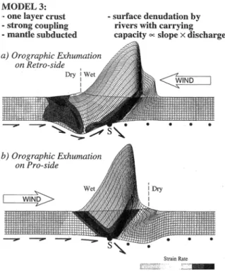
Figure 3: Plane-strain finite element models of crustal deformation driven by mantle subduction (at point S) and surface denudation. Surface erosion is by rivers that are charged by orographically enhanced precipitation. Direction of mantle subduction is indicated by half arrows at base of model; atmospheric transport direction by open arrow. The grid tracks the motion of the model crust and shows its deformation; the grid shown above the surface (thick line) provides a measure of total denudation. Grey-shading indicates strain rates. a) Wind opposed to subduction polarity and denudation focused on “retro” side of the orogen: rocks of highest metamorphic grade are exposed at low elevation close to “retro” front of orogen; b) Wind direction parallel to subduction polarity and denudation focused on “pro” side of orogen: highest-grade rocks are exposed in central part of orogen. After Beaumont et al. [2000].
erosion, sediment transport and deposition also influences the stress distribution within an orogenic prism [e.g., Avouac and Burov, 1996; Chalaron et al., 1996; Dahlen, 1990; Dahlen and Suppe, 1988;
Koons, 1995]. Finally, advection of rock in rapidly eroding mountain belts will strongly influence the
temperature structure and rheology of the prism [Batt and Braun, 1997; Koons et al., 2002; Zeitler et
al., 2001]. The latter two mechanisms will directly influence the structural style and tectonic
evolution of an orogen [Beaumont et al., 2000; Willett et al., 1993]. As the orographic effect of mountain belts leads to an asymmetric distribution of precipitation and therefore possibly erosional efficiency, models that couple tectonics and erosion through the stress distribution, thermal structure and rheology, predict that fundamental asymmetries in the topography and distribution of peak metamorphic grades within an orogen may be controlled by the relative directions of lithospheric (plate underthrusting) and atmospheric (storm direction) transport (Figure 3) [Beaumont et al., 1992;
Willett et al., 1993; Willett, 1999]. Although denudational control of the tectonic style of orogens has
been demonstrated in models of the type shown in Figure 3, it has remained an inference for natural orogens [e.g., Hoffman and Grotzinger, 1993]. Willett [1999] has argued that the Southern Alps of New Zealand and the Olympic Mountains of the NW USA represent type examples of the effects of denudation concentrated on the “retro” and “pro” side of an orogen, respectively. Taiwan possibly represents another case of preferential denudation of the “pro” prism.
In parallel with the possible climatic control on tectonic style (through erosion), the influence that tectonics may have on climate has also been strongly debated over the last decade. Possible tectonic forcing of climate may take place at different scales. On local scales, the growth of mountain belts leads to the instalment of orographic precipitation systems, as noted above. On regional scales, such growth may perturb atmospheric circulation patterns, the best example of which is the control of the Tibetan Plateau on the Indian Monsoon system [Molnar et al., 1993]. Finally, enhanced silicate weathering of uplifted mountain belts may lead to drawdown of atmospheric CO2 and its burial in
marine sediments, leading to global climatic cooling [Raymo and Ruddiman, 1992]. The rapid burial of organic carbon trapped in the large volumes of sediment derived from the Himalaya may contribute significantly to such atmospheric CO2 drawdown [France-Lanord and Derry, 1997].
However, these models remain controversial because of the extreme difficulty in unambiguously demonstrating and quantifying surface uplift [England and Molnar, 1990; Hay et al., 2002; Molnar
and England, 1990]. In particular, Molnar and England [1990] have argued that instead of climatic
cooling in response to widespread late Cenozoic tectonic uplift, we in fact observe relief development and isostatic uplift of mountain peaks in response to late Cenozoic climatic cooling and instability.
Resolving the above controversy will require specific data acquisition as well as the further development of numerical models. If a global Late Cenozoic increase in denudation rates can be demonstrated, independently of tectonic setting, then a climatic control appears reasonable [Zhang et
al., 2001]. On the other hand, the Molnar and England [1990] model of isostatic uplift of mountain
peaks in response to increased denudation rates can only work if erosion processes driven by a colder and more instable climate lead to relief enhancement [Montgomery, 1994; Whipple et al., 1999]. Whether this is the case, particularly in response to the glaciation of mountain ranges, is unclear at present. On the one hand, several studies have indicated that glaciation indeed leads to an increase in relief [Kirkbride and Matthews, 1997; Montgomery, 2002; Small and Anderson, 1995, 1998]; on the other hand, theoretical considerations and observations in the NW Himalaya suggest that increased glacial denudation rates lead to a decrease in relief [Brozovic et al., 1997; Tomkin and Braun, 2002;
![Figure 1. Cumulative probability of average erosion rates in the world’s river basins [after Ring et al., 1999; data from Milliman and Syvitski, 1992]](https://thumb-eu.123doks.com/thumbv2/123doknet/14439154.708915/23.892.113.454.748.1087/figure-cumulative-probability-average-erosion-basins-milliman-syvitski.webp)


![Figure 5. A) Cartoon of the landsliding algorithm developed by Champel et al. [2002], showing relationships between topographic slope b, critical friction angle j and dip of sliding plane q c](https://thumb-eu.123doks.com/thumbv2/123doknet/14439154.708915/32.892.116.741.768.1025/cartoon-landsliding-algorithm-developed-champel-relationships-topographic-critical.webp)