(1)HAL Id: tel-00088994
https://tel.archives-ouvertes.fr/tel-00088994
Submitted on 8 Aug 2006
HAL is a multi-disciplinary open access
archive for the deposit and dissemination of
sci-entific research documents, whether they are
pub-lished or not. The documents may come from
teaching and research institutions in France or
abroad, or from public or private research centers.
L’archive ouverte pluridisciplinaire HAL, est
destinée au dépôt et à la diffusion de documents
scientifiques de niveau recherche, publiés ou non,
émanant des établissements d’enseignement et de
recherche français ou étrangers, des laboratoires
publics ou privés.
To cite this version:
Philippe Sorrel. The Aral Sea: a palaeoclimate archive. Mineralogy. Universität Potsdam, 2006.
English. �tel-00088994�
Laboratoire PEPS, UMR 5125, Université Claude Bernard – Lyon 1, France
Doctoral thesis
Presented to obtain the Academic Degrees
“Doktor der Naturwissenschaften an der Universität Potsdam”
and
“Docteur de l’Université Claude Bernard – Lyon 1”
under the convention of
“Gemeinsam Betreute Promotion”
“Cotutelle de thèse”
Speciality: Geology
THE ARAL SEA: A PALAEOCLIMATE ARCHIVE
by
Philippe SORREL
Defended in Potsdam 13 July 2006
Joined German-French examination committee
Roland OBERHÄNSLI, Universität Potsdam PhD supervisor, reviewer
Jean-Pierre SUC, Université C. Bernard-Lyon I PhD supervisor
Christophe LÉCUYER, Université C. Bernard-Lyon I Reviewer
Volker MOSBRUGGER, Forschungsinstitut Senckenberg Reviewer
Gerald HAUG, GeoForschungsZentrum Potsdam Examination
Hedwig OBERHÄNSLI, GeoForschungsZentrum Potsdam Examination
Martin HEAD, Brock University, Canada Examination
Spéranta-Maria POPESCU, Université C. Bernard-Lyon I Examination
Acknowledgments
Since beginning of 2003, this PhD thesis under the German-French convention of
“Gemeinsam Betreute Promotion” / “Co-tutelle de thèse” offered me the opportunity to share
my time between the GeoForschungsZentrum Potsdam, the University Claude Bernard of
Lyon and the University of Potsdam. Today I would like to thank all the people who
contributed to the progress of this thesis, as well as all those that I have met since the 4
th
of
November 2002 and who have enriched me a lot, both scientifically and personally.
I gratefully acknowledge the project CLIMAN, from where this thesis outcomes. This
work was supported by the INTAS organization of the European Union (Project N° Aral
00-1030) and the German Science Foundation (DeutscheForschungGemeinshaft, under contract
436 RUS 111/663 – OB 86/4). I also acknowledge the GFZ Potsdam and the University of
Lyon 1 for providing me all the scientific, infrastructural and friendly contributions during
these last three years.
First of all, I would like to warmly thank Dr. Hedi Oberhänsli, my supervisor at the GFZ
Potsdam and the initiator of the project CLIMAN, who gave me the opportunity to be
involved in a wonderful international team, and entrusted me with this PhD thesis. She was a
great mentor, provided me countless fruitful ideas and the required support on my work. She
was always trustful with my initiatives and every day extremely motivated.
To similar regards, I warmly thank Prof. Dr. Jean-Pierre Suc and Dr. Speranta-Maria
Popescu from the University of Lyon, for the considerable support they provided me day after
day. They were formidable supervisors. I thank Jean-Pierre Suc for his precious and great
experience on pollen grain taxonomy and his fruitful ideas. He also made my participation to
several congresses possible and highly encouraged me to present my results during internal
seminars at the University of Lyon. I warmly thank Speranta-Maria Popescu for introducing
me to the identification of dinoflagellate cysts, for her great kindness and her black coffee.
She was a wonderful roommate.
Particular thanks are addressed to my two supervisors in chief, Prof. Dr Roland
Oberhänsli (University of Potsdam) and Prof. Dr. Jean-Pierre Suc (University Claude
Bernard-Lyon 1) who made this collaboration between respective institutions possible. I
acknowledge the administration staff from both universities for their fast and pleasant way in
solving problems. They were of great help.
I would like to gratefully thank Dr Stefan Klotz (University of Tübingen) who introduced
me to the “probability mutual climatic spheres” (PCS) method. Many thanks also for our
countless discussions and for his contributions to this work. He was also a very good friend,
who always enjoyed the idea to share a beer at the “Palais de la bière” of Lyon, sometimes
late in the night.
Prof. Dr. Martin Head (Brock University, Canada) is kindly acknowledged for his
precious help during my first steps in learning taxonomy of dinoflagellate cysts. I also thank
him for his kindness in inviting me three days at the Geographical Institute of Cambridge, and
for his hospitality. I had the great opportunity to share his house and to meet his sweet family.
I warmly thank Prof. Gerald Haug (GFZ Potsdam, Universität Potsdam) for his precious
advices, his enthusiasm and his support during my PhD.
I would like to thank Dr. Nick Boroffka (GFZ Potsdam) for his help and his kindness
during the CLIMAN expedition in the delta of the Amu Darya in summer 2003. He was
always very patient with me and often supported my bad character. He is someone that I will
not forget, and receives my sincere admiration. I also thank him for the fruitful scientific
discussions we had together, both on the field and later in Potsdam.
Thanks to all members of the CLIMAN project from various horizons, especially Patrick
Austin and Dr. Anson Mackay (Univeristy College of London), Dr. Danis Nourgaliev (Kazan
University), Dr. Jana Friedrich (AWI Bremerhaven) Dr. Sergey Krivonogov (RAS
Novosibirsk) and Dr. Dietmar Keyser (University of Hamburg). Thanks to all members of the
NATO project for the very pleasant time we had in Moscow in October 2005, especially Dr.
Peter Zavialov and Dr. Phil Sapozhnikov (Shirshov Institute of Oceanology, Moscow) and
Christine Heim (AWI Bremerhaven).
I would like to warmly thank Prof. Gerald Haug and Prof. Axel Bronstert (Universität
Potsdam) for their presence in the examination committee, as well as Prof. Roland Oberhänsli
(Universität Potsdam), Prof. Volker Mosbrugger (Forschungsinstitut Senckenberg Frankfurt),
Prof. Christophe Lécuyer (Université Claude Bernard-Lyon 1) and Prof. Martin Head (Brock
University) for accepting to evaluate this work.
Another big thank to Dominique Barbe and Sophie Passot for their tremendous help in
printing the manuscripts, and above all, for their kindness and availability.
I especially gratefully thank Dr. Francois Demory (University of Marseille) for his
countless advices during the first year of my PhD. He always helped me when my scientific
competence reached its borders. He was a nice flatmate in Potsdam too. I thank his wife, Dr.
Juliette Lamarche (University of Marseille) for her daily good mood and for her
recommendable “tarte au Maroilles”.
Many thanks to Matthias Zopperitsch for his friendship during the 3 years of this PhD and
Samuel Jaccard (ETH Zürich) for the nice moments we had together in Bremen. Great thanks
to Christophe Pelosi for being a wonderful flatmate in Potsdam.
Thanks are adressed to Andrew Cavanagh, Hans von Suchodoletz, Fabien Magri, Youri
Maystrenko, Judith Sippel, Leni, Sushma Prasad, Björn Lewerenz, Andrea Rieser and Katka
Novotna for their good mood and the nice moments at the 4
th
level of GFZ Potsdam.
Thanks to Sam, Matt and Tof for being true friends. Thanks to my father for his
disponibility and his patience during the stressful period of writing.
Je remercie enfin du fond du coeur Cloé, ainsi que ma mère, pour leur soutien permanent
et pour avoir supporté mes accès d’humeur, mes découragements. Merci à toi Cloé de m’avoir
accompagné jusqu’au bout, même jusqu’à Potsdam. Ce travail est dédié à ma mère, qui a
toujours cru en moi et qui a suivi avec passion chaque étape, chaque moment de ce travail au
cours des 3 dernières années. Un immense merci à vous.
Abstract
The intracontinental endorheic Aral Sea, remote from oceanic influences, represents an
excellent sedimentary archive in Central Asia that can be used for high-resolution
palaeoclimate studies. We performed palynological, microfacies and geochemical analyses on
sediment cores retrieved from Chernyshov Bay, in the NW part of the modern Large Aral Sea.
The most complete sedimentary sequence, whose total length is 11 m, covers approximately
the past 2000 years of the late Holocene.
High-resolution palynological analyses, conducted on both dinoflagellate cysts
assemblages and pollen grains, evidenced prominent environmental change in the Aral Sea
and in the catchment area. The diversity and the distribution of dinoflagellate cysts within the
assemblages characterized the sequence of salinity and lake-level changes during the past
2000 years (Chapter III). Due to the strong dependence of the Aral Sea hydrology to inputs
from its tributaries, the lake levels are ultimately linked to fluctuations in meltwater
discharges during spring. As the amplitude of glacial meltwater inputs is largely controlled by
temperature variations in the Tien Shan and Pamir Mountains during the melting season,
salinity and lake-level changes of the Aral Sea reflect temperature fluctuations in the high
catchment area during the past 2000 years. Dinoflagellate cyst assemblages document lake
lowstands and hypersaline conditions during ca. 0–425 AD, 920–1230 AD, 1500 AD, 1600–
1650 AD, 1800 AD and since the 1960s, whereas oligosaline conditions and higher lake
levels prevailed during the intervening periods. Besides, reworked dinoflagellate cysts from
Palaeogene and Neogene deposits happened to be a valuable proxy for extreme sheet-wash
events, when precipitation is enhanced over the Aral Sea Basin as during 1230–1450 AD. We
propose that the recorded environmental changes are related primarily to climate, but may
have been possibly amplified during extreme conditions by human-controlled irrigation
activities or military conflicts (Chapter VI). Additionally, salinity levels and variations in
solar activity show striking similarities over the past millennium, as during 1000–1300 AD,
1450–1550 and 1600–1700 AD when low lake levels match well with an increase in solar
activity thus suggesting that an increase in the net radiative forcing reinforced past Aral Sea’s
regressions.
On the other hand, we used pollen analyses to quantify changes in moisture conditions in
the Aral Sea Basin (Chapter IV). High-resolution reconstruction of precipitation (mean
annual) and temperature (mean annual, coldest versus warmest month) parameters are
performed using the “probability mutual climatic spheres” method, providing the sequence of
climate change for the past 2000 years in western Central Asia. Cold and arid conditions
prevailed during ca. 0–400 AD, 900–1150 AD and 1500–1650 AD with the extension of xeric
vegetation dominated by steppe elements. Conversely, warmer and less arid conditions
occurred during ca. 400–900 AD and 1150–1450 AD, where steppe vegetation was enriched
in plants requiring moister conditions. Change in the precipitation pattern over the Aral Sea
Basin is shown to be predominantly controlled by the Eastern Mediterranean (EM) cyclonic
system, which provides humidity to the Middle East and western Central Asia during winter
and early spring. As the EM is significantly regulated by pressure modulations of the North
Atlantic Oscillation (NAO) when the system is in a negative phase, a relationship between
humidity over western Central Asia and the NAO is proposed.
Besides, laminated sediments record shifts in sedimentary processes during the late
Holocene that reflect pronounced changes in taphonomic dynamics (Chapter V). In Central
Asia, the frequency of dust storms occurring during spring when the continent is heating up is
mostly controlled by the intensity and the position of the Siberian High (SH) Pressure System.
Using titanium (Ti) content in laminated sediments as a proxy for aeolian detrital inputs,
changes in wind dynamics over Central Asia is documented for the past 1500 years, offering
the longest reconstruction of SH variability to date. Based on high Ti content, stronger wind
dynamics are reported from 450–700 AD, 1210–1265 AD, 1350–1750 AD and 1800–1975
AD, reporting a stronger SH during spring. In contrast, lower Ti content from 1750–1800 AD
and 1980–1985 AD reflect a diminished influence of the SH and a reduced atmospheric
circulation. During 1180–1210 AD and 1265–1310 AD, considerably weakened atmospheric
circulation is evidenced.
As a whole, though climate dynamics controlled environmental changes and ultimately
modulated changes in the western Central Asia’s climate system, it is likely that changes in
solar activity also had an impact by influencing to some extent the Aral Sea’s hydrology
balance and also regional temperature patterns in the past (Chapter VI).
Résumé
La Mer intracontinentale endoréique de l’Aral, éloignée de toute influence océanique, constitue en
Asie Centrale une excellente archive sédimentaire pour des études paléoclimatiques à haute résolution.
Nous avons effectué une analyse palynologique, sédimentologique et géochimique sur des carottages
sédimentaires effectués dans la Baie de Chernyshov, située au nord-ouest de l’actuelle Grande Mer
d’Aral. La séquence sédimentaire la plus complète mesure 11 m et représente les 2000 dernières
années de l’Holocène terminal.
L’étude palynologique, conduite conjointement sur des assemblages de kystes de dinoflagellés et
de grains de pollen, a mis en évidence de profonds changements environnementaux en Mer d’Aral,
ainsi que dans le bassin Aralien. Les variations d’assemblages de kystes de dinoflagellés (diversité,
distribution des espèces) ont permis d’établir la séquence des variations de salinité et du niveau du lac
au cours des 2000 dernières années (Chapitre III). En raison de l’étroite dépendence de l’hydrologie
de la Mer d’Aral aux apports fluviaux de l’Amu Darya et de la Syr Darya, les variations de niveau du
lac sont étroitement liées à l’apport d’eaux résultant de la fonte des neiges en altitude au printemps.
Or, l’amplitude de ces apports étant principalement contrôlée par les variations de température
printanières dans les massifs du Tien Shan et du Pamir au cours de la fonte, les variations de salinité et
de niveau de la Mer d’Aral traduisent essentiellement des fluctuations de température dans le bassin
versant au cours des 2000 dernières années. Ainsi, les assemblages de kystes de dinoflagellés
caractérisent des épisodes de bas niveau de la Mer d’Aral accompagnés d’une forte augmentation de la
salinité au cours des périodes 0–425, 900–1230, 1500, 1600–1650 et 1800 après J.C., ainsi qu’après
les années 1960. Inversement, un retour vers des conditions de faible salinité associées à une hausse du
niveau du lac est documenté pour les périodes intermédiaires. Par ailleurs, la présence de kystes de
dinoflagellés remaniés des dépôts Paléogène et Néogène alentours caractérise des évènements de
désagrégation intense des berges lors d’une hausse significative des précipitations sur le bassin
Aralien, notamment au cours de la période 1230–1450 après J.C. Nous proposons que les changements
environnementaux enregistrés sont principalement liés à des changements climatiques mais qu’ils ont
également pu être amplifiés par l’homme lors de conditions extrêmes, via une irrigation non-maîtrisée
et/ou des conflits militaires (Chapitre VI). En outre, les variations de salinité montrent de fortes
similitudes avec celles de l’activité solaire au cours du dernier millénaire, notamment pour les périodes
1000–1300, 1450–1550 et 1600–1700 après J.C. où les périodes de bas niveau du lac correspondent à
une activité solaire accrue, suggérant qu’une augmentation du bilan radiatif ait renforcé les régressions
de la Mer d’Aral dans le passé.
Parallèlement, le contenu du sédiment en grains de pollen a été analysé afin de mettre en évidence
des changements environnementaux, et notamment des variations d’humidité dans le bassin Aralien au
cours des 2000 dernières années (Chapitre IV). Une reconstruction quantitative à haute résolution du
taux de précipitation (moyenne annuelle) et des températures (moyenne annuelle, mois le plus froid
versus le plus chaud) a été réalisée à l’aide de la méthode dite de “probabilité des sphères climatiques
mutuelles”, permettant d’obtenir la séquence chronologique des changements climatiques en Asie
Centrale. Un climat froid et aride domine au cours des périodes 0–400, 900–1150 et 1500–1650 après
J.C., caractérisé par l’extension d’une végétation de type désertique avec des éléments de steppe. En
revanche, un climat plus chaud et moins sec apparaît au cours des périodes 400–900 et 1150–1450
après J.C., caractérisé par une végétation steppique enrichie en plantes exigeant des conditions
d’humidité plus élevées. Les variations de précipitation enregistrées dans le bassin Aralien au cours
des 2000 dernières années sont principalement contrôlées par le système cyclonique de la
Méditerranée Orientale qui fournit l’humidité nécessaire au Moyen Orient et en Asie Centrale à la
transition hiver–printemps. Ce système cyclonique étant étroitement lié aux modulations de pression
régulées par l’Oscillation de l’Atlantique Nord (NAO), une relation entre humidité en Asie Centrale et
le NAO en phase négative est proposée.
Enfin, les sédiments laminés des carottages étudiés ont enregistré des changements marqués de la
sédimentation au cours de l’Holocène terminal qui révèlent des bouleversements importants de la
dynamique d’apports du matériel sédimentaire (Chapitre V). En Asie Centrale, la fréquence des
tempêtes de poussières s’intensifie au printemps lorsque le continent se réchauffe, et est ainsi
principalement contrôlée par l’intensité et la position de l’anticyclone Sibérien sur le continent. Une
analyse semi-quantitative du contenu du sédiment en Titanium, révélateur fiable d’apports détritiques
d’origine éolienne, a permis d’établir la séquence chronologique des variations de la dynamique
éolienne en Asie Centrale au cours des 1500 dernières années, représentant aussi la plus longue
reconstruction dans le temps de l’intensité de l’anticyclone Sibérien établie jusqu’ici. Ainsi, une
intensification de la dynamique éolienne est documentée pour les périodes 450–700, 1210–1265,
1350–1750 et 1800–1975 après J.C. En revanche, de faibles concentrations en Titanium (1750–1800 ;
1980–1985 après J.C.) caractérisent une réduction significative de l’intensité de l’anticyclone Sibérien
et une circulation atmosphérique plus stable. Au cours des périodes 1180–1210 et 1265–1310 après
J.C., une profonde modification de la circulation atmosphérique s’installe en Asie Centrale. En Mer
d’Aral, elle se caractérise par une réduction considérable des apports détritiques éoliens.
En définitive, si l’ensemble des intéractions entre différents systèmes climatiques ont contrôlé les
changements environnementaux en Asie Centrale et modulé les variations climatiques au cours de
l’Holocène terminal, il est probable que les variations de l’activité solaire aient eu un impact notable
sur l’évolution du bilan hydrique de la Mer d’Aral au cours des 1000 dernières années (Chapitre VI).
Zusammenfassung
Der Aralsee ist ein intrakontinental gelegenes endorheisches Gewässer fernab von ozeanischen
Einflüssen, welches ein exzellentes sedimentäres Archiv für hochauflösende Paläoklimastudien in
Zentralasien darstellt. In der vorliegenden Studie wurden umfangreiche palynologische, mikrofazielle
und geochemische Analysen anhand von mehreren Bohrkernen aus der Chernyshov-Bucht im NW des
heutigen Großen Aralsees durchgeführt. Die vollständigste der erbohrten Sequenzen weist dabei eine
Länge von 11 m auf und beinhaltet näherungsweise die letzten 2000 Jahre des Holozän.
Die hochauflösenden palynologischen Analysen der Studie, welche sowohl die Untersuchung von
Dinoflagellatenzysten als auch Pollen beinhaltet, zeugen von einschneidenden Umweltveränderungen
im Aralsee und seinem Einzugsgebiet. Die Untersuchung von Diversität und räumlicher Verbreitung
der fossilen Dinoflagellatenzysten vermittelt dabei ein genaues Bild von den Salinitäts- und
Seespiegeländerungen der letzten 2000 Jahre (Kapitel III). Aufgrund der weitgehenden Abhängigkeit
der hydrologischen Verhältnisse des Aralsees von der Wasserführung seinen tributären Flüsse, hängt
sein Seespiegel unmittelbar von den Schmelzwasserzuflüssen im Frühjahr ab. Da der
Schmelzwasserzufluss seinerseits mit den Temperaturveränderungen im Tien Shan und Pamir
während der Schneeschmelze in Verbindung steht, spiegeln die Salinität und der
Paläo-Seespiegel des Aralsees folglich die Temperaturveränderungen im hochgelegenen Einzugsgebiet des
Aralsees wider. Die Untersuchung der fossilen Dinoflagellatenzysten belegt besonders niedrige
Seestände und hypersaline Bedingungen während der Perioden 0–425 AD, 920–1230 AD, 1500 AD,
1600 AD, 1800 AD und seit 1960, wohingegen oligohaline Bedingungen und höhere Seestände
zwischen diesen Phasen dokumentiert sind. Ferner stellen umgelagerte Dinoflagellatenzysten aus
Paläogenen und Neogenen Ablagerungen wertvolle Proxies für den Beleg von extremen
Flächenspülereignissen dar, wie sie beispielsweise 1230–1450 AD aufgetreten und durch sehr hohe
Niederschläge dokumentiert sind. Anhand der in der Studie erarbeiteten Daten ist davon auszugehen,
dass die am Aralsee nachgewiesenen Umweltveränderungen im Wesentlichen von klimatischen
Änderungen induziert wurden, durch historischen Bewässerungsfeldbau oder militärischen Konflikten
jedoch noch verstärkt werden konnten (Kapitel VI). Darüber hinaus zeigen die
Seestandsveränderungen eine sehr hohe Korrelation mit der Sonnenaktivität im letzten Jahrtausend,
wie etwa während den Perioden 1000–1300 AD, 1450–1550 und 1600–1700 AD. Hierbei
korrespondieren niedrige Seestände und regressive Phasen mit zunehmender Sonnenaktivität und
daher mit erhöhter Nettostrahlung.
Komplementär zu der Untersuchung von Dinoflagellatenzysten liefert die Pollenanalyse wertvolle
Klimadaten für das Becken des Aralsees (Kapitel VI). Verschiedene Temperatur- (Jahresmittel,
kältester gegen wärmster Monat) und Niederschlagsparameter wurden mit Hilfe der Methode der
„probability mutual climatic spheres“ quantitative ausgewertet, womit die Klimaentwicklung im
westlichen Zentralasien der letzten 2000 Jahre nachvollzogen werden konnte. Kalte und aride
Bedingungen wiesen demnach die durch trockenangepasste Vegetation und Steppenelementen
geprägten Perioden 0–400 AD, 900–1150 AD und 1500–1650 AD auf. Andererseits traten warme und
weniger aride Klimabedingungen in den durch niederschlagsbedürftigere Pflanzen gekennzeichneten
Zeiträumen 400–900 AD and 1150–1450 AD in den Vordergrund. Die Studie zeigt für das Becken des
Aralsees, dass die Veränderungen im Niederschlagsmuster hauptsächlich vom zyklonalen System des
östlichen Mittelmeergebietes (EM) gesteuert werden, welches den nahen Osten und das westliche
Zentralasien mit Feuchtigkeit im Winter und Frühjahr versorgt. Da seinerseits das EM maßgeblich von
Luftdruckänderungen der Nordatlantischen Oszillation (NAO) während seiner negativen Phase
reguliert wird, ist ein Zusammenhang zwischen der Feuchtigkeit im westlichen Zentralasien und dem
NAO anzunehmen.
Außerdem belegen die laminierten Sedimente Veränderungen in den Sedimentationsprozessen
während des späten Holozän, sowie ausgeprägte Änderungen im taphonomischen Verhalten (Kapitel
V). In Zentralasien hängt die Häufigkeit der im Frühjahr auftretenden Staubstürme hauptsächlich von
der Intensität und der Position des Sibirienhochs (SH) ab. Der Gehalt an Titanium (Ti) als Proxy für
äolischen Eintrag in den laminierten Sedimenten erlaubt die Rekonstruktion von winddynamischen
Veränderungen in Zentralasien in den letzten 1500 Jahren. Die Studie beinhaltet daher die bislang
längste Analyse der Variabilität des SH. Hohe Titaniumwerte sprechen für eine stärkere Winddynamik
während den Perioden 450–700 AD, 1210–1265 AD, 1350–1750 AD und 1800–1975 AD, und
dokumentieren demzufolge eine stärker ausgeprägtes SH während des Frühjahrs. Umgekehrt belegen
geringe Titaniumwerte für die Zeit von 1180–1210 AD, 1265–1310 AD, 1750–1800 AD und 1980–
1985 AD einen reduzierten Einfluss des SH.
Zusammengefasst, obgleich die allgemeinen klimadynamischen Prozesse natürliche
Umweltveränderungen bedingen und letztlich auch Modulationen des westlichen zentralasiatischen
Klimasystem bewirken, ist es dennoch wahrscheinlich, dass Veränderungen der Solaraktivität
gleichsam einen Einfluss hatten und bis zu einem gewissen Grad die Wasserbilanz am Aral See sowie
die regionale Temperaturen in der Vergangenheit veränderten (Kapitel VI).
Contents
I. Introduction ... i
I.1. Aims of the study ...i
I.2. Climate variability over the Eurasian continent and its influence on
Central Asia and the Aral Sea Basin ...iv
I.3. Teleconnections...x
I.4. Structure of the thesis...xiv
II. Material and Methods – site location, sediment properties and
chronology... 1
II.1. Coring sites: the CLIMAN summer 2002 campaign ...1
II.2. Sediment preservation and lithology...2
II.3. Inorganic proxies...6
II.3.1. Physical properties ...6
II.3.2. X-ray fluorescence (XRF) spectrometry – a proxy of geochemical
variability of sediments ...8
II.3.3. Microfacies analyses: a proxy of sedimentary dynamics...10
II.4. Organic proxies ...10
II.4.1. Dinoflagellate cysts – a proxy of hydrological change ...10
II.4.2. Pollen grains – a proxy of land moisture conditions...11
II.4.2. Climate quantification and reconstruction based on pollen data...12
II.5. Dating and chronology ...13
III. Hydrographic development of the Aral Sea during the last 2000
years based on a quantitative analysis of dinoflagellate cysts ... 17
Abstract ...17
III.1. Introduction ...18
III.2. Materials and methods ...20
III.2.1. Sedimentological description ... 20
III.2.2. Age model ... 22
III.2.3. Sample processing and palynological analysis... 23
III.2.4. Ecological groupings of dinoflagellate cysts and other palynomorphs 24
III.3. Results ...31
III.4. Discussion ...35
III.4.1. Palaeoenvironmental reconstruction ...35
III.4.2. Palaeoclimatic changes inferred from dinoflagellate cysts ... 38
III.4.3. Human influence on hydrography...42
III.4.4. Conclusions ... 43
References ...44
IV. Climate variability in the Aral Sea Basin (Central Asia) during
the late Holocene based on vegetation changes ... 49
Abstract ...49
IV.1. Introduction ...50
IV.2.1. Site, sediments and chronology ... 52
IV.2.2. Sample processing... 53
IV.2.3. Taxonomy and ecological grouping of pollen grains...54
IV.2.4. Climate reconstruction ... 55
IV.3. Results ...56
IV.4. Vegetation patterns derived from the pollen record...60
IV.5. Climate reconstruction ...62
IV.6. Discussion and conclusions...65
References ...68
V. Control of wind dynamics in the Aral Sea Basin during the late
Holocene ... 71
Abstract ...71
V.1. Introduction ...72
V.2. Materials and methods ...73
V.2.1. Coring locations ... 73
V.2.2. Thin sections... 74
V.2.3. X-Ray Fluorescence (XRF) scanning, magnetic susceptibility
measurements and X-Ray Diffraction (XRD)... 74
V.2.4. Lithology...75
V.2.5. Chronology... 75
V.3. Results ...77
V.3.1. Physical and geochemical variability in Core CH1 (Fig. 5.3) ...77
V.3.2. Close-up interval 4.58–5.28 m ... 77
V.4. Interpretation and discussion...81
V.4.1. Reconstruction of environmental dynamics during 1150–1400 AD ... 81
V.4.2. Control of wind dynamics in the Aral Sea...84
V.5. Conclusions ...87
References ...88
VI. Synthesis... 91
VI.1. Human influence on the hydrological balance (Boroffka et al., in press) ...91
VI.2. Natural forcing factors ...96
VI.2.1. Climate dynamics (internal forcing mechanisms) ... 96
VI.2.2. External forcing ... 99
VII. Concluding remarks ... 103
List of Figures
1.1: The Aral Sea, located in Central Asia, and the coring locations ... ii
1.2: Low-pressure fields moving over the Middle East and western Central Asia... v
1.3: The Siberian High Pressure Cell... vi
1.4: Temperature, global radiation, wind speed, number of frost / wet days, cloud
cover and precipitation climatologies for winters and 1961–1990 ... vii
1.5: Monthly precipitation anomalies over Central and Southwest Asia for January
1951–September 2001... ix
1.6: Correlation maps of different climate variables with Arctic Oscillation (AO) time
series... xii
1.7: Correlation maps of 1000-hPa geopotential height with Southern Oscillation
Index (SOI) time series ... xiii
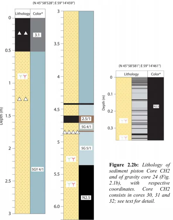
2.1: Seismic profile from Chernyshov Bay... 1
2.2: Lithology of sediment piston Cores CH1, CH2 and of gravity core 24 from
Chernyshov Bay ... 3/4
2.3: Stacked variations in Gamma-ray density, magnetic susceptibility and X-Ray
fluorescence analyses in Cores CH1 and CH2... 5
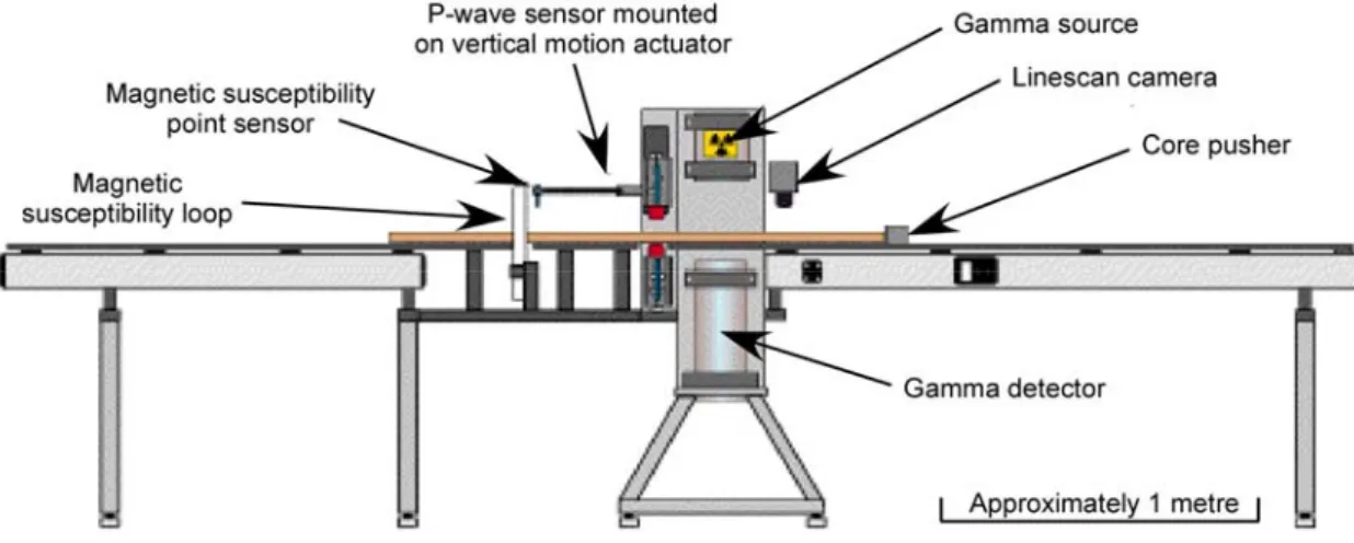
2.4: Schematic representation of the GeoTek device... 6
2.5: Reproductibility of XRF measurements at different resolution steps... 9
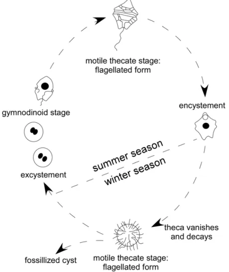
2.6: Schematic diagramm representing the life cycle history of dinoflagellates ... 11
2.7: Correlation between different magnetic susceptibility records from Chernyshov
Bay ... 15
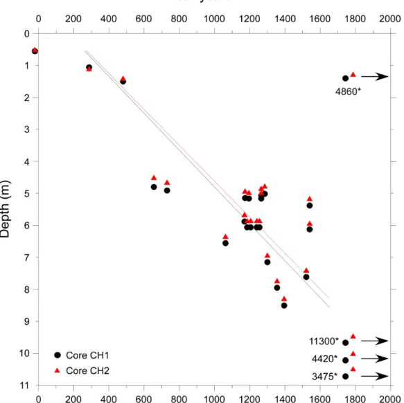
2.8: Relation age / depth for Chernyshov Bay Cores CH1 and CH2... 16
3.1: Location map of the present Aral Sea and the study area... 19
3.2: Lithology of section CH2/1 ... 21
3.3: Age model for section CH2/1 ... 22
3.4: Relative abundance of dinoflagellate cysts and freshwater algae from section
CH2/1, ecostratigraphic zonation and inferred salinity fluctuations... 25
3.5: Concentrations of all aquatic palynomorphs counted in section CH2/1... 26
3.6: Dinoflagellate cysts and other aquatic palynomorphs from Chernyshov Bay.
Light micrographs in bright-field... 27
3.7: Dinoflagellate cysts and other aquatic palynomorphs from Chernyshov Bay.
Light micrographs in bright-field... 29
3.8: Dinoflagellate cysts from Chernyshov Bay. Light micrographs in bright-field ... 31
3.9: Morphotypes of Lingulodinium machaerophorum from Chernyshov Bay.
Scanning electron micrographs ... 33
3.10: Dinoflagellate cysts and other aquatic palynomorphs from Chernyshov Bay.
Scanning micrographs ... 34
3.11: Correlation of palaeoenvironmental changes during the last 2000 years with
the tree-ring width record of Esper et al. (2002) ... 39
4.1: Location map of the Aral Sea and the study area ... 51
4.2: Simplified lithological profile and age model for section CH2/1... 52
4.3: Simplified detailed pollen diagramm for section CH2/1 ... 57
4.4: Pollen synthetic diagramm for section CH2/1 ... 59
4.5: Reconstruction of precipitation and temperature parameters for section CH2/1
inferred from the pollen assemblages... 63
4.6: Comparison between reconstructed climate parameters from section CH2/1 and
the δ
18
O record of Schilman et al. (2002) from the Eastern Mediterranean region ... 66
5.1: Location map of the study area and simplified lithology of Core CH1... 73
5.2: Age-depth relation for Core CH1 ... 76
5.3: Stacked magnetic susceptibility and X-Ray fluorescence data in Core CH1 ... 78
5.4: Thin-section images of the microfacies types identified in Core CH1 ... 80
5.5: High-resolution XRF and microfacies proxy data in Core CH1... 83
5.6: Comparison between the bulk Titanium content in Core CH1, the non-seasalt
Potassium and the Siberian High records of Meeker & Mayewski (2002)... 85
6.1: The respective role of human influence and climate change on the Aral Sea’s
hydrological balance during the past 2000 years ... 92
6.2: Past environmental and climate variability in the Aral Sea Basin during the last
2000 years: climate dynamics ... 97
6.3: Comparison between environmental proxies in the Aral Sea Basin and
multi-proxy reconstructions of solar activity during the past millennium ... 100
7.1: Present-day atmospheric dynamics for winters and summers in Central Asia ... 104
List of tables
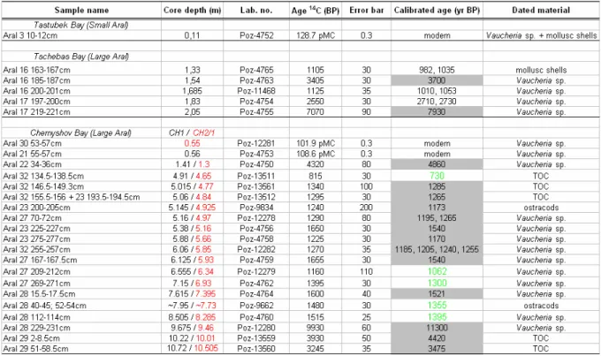
Table 1:
14
C dating measurements performed on Chernyshov Bay cores... 14
Chapter I: Introduction
Reconstruction of past climate from palaeoclimate proxy data is important for improving
constraints on the role and the scope of natural climate variability onto environments. A
number of efforts have been made to reconstruct variations in Northern Hemisphere
temperature within the past millennium using well-dated, high-resolution proxy records (e.g.
Overpeck et al., 1997; Jones et al., 1998, 2001; Mann et al., 1998, 1999; Pfister, 1999;
Bradley, 2000, 2003; Briffa, 2000; Briffa et al., 2001, 2002; Crowley, 2000; Folland et al.,
2001; Esper et al., 2002a; Crowley and Lowery, 2003; Mann and Jones, 2003; Cook et al.,
2004; von Storch et al., 2004; Moberg et al., 2005). Most of the climate shift events over the
past 1500 years often coincided with reorganisations of human societies (Buckland et al.,
1995; Cullen et al., 2000; de Menocal, 2001; Haug et al., 2003). Detailed high-resolution
temporal and spatial patterns of climate change are available for Europe over the last 300–600
years (e.g. Appenzeller et al., 1998; Luterbacher et al., 2001, 2002; 2004; Büntgen et al.,
2005; Pauling et al., 2005; Casty et al., 2005a, 2005b, 2005c; Jacobeit et al., 2003; Slonosky
et al., 2000, 2001), in the Artic region (Overpeck et al., 1997) and in northern Asia over the
past 2000–4000 years (Naurzbaev et al., 2002; Hantemirov and Shiyatov, 2002). However,
hemispheric-scale reconstructions provide little information about regional scale anomalies in
both temperature and precipitation. Therefore, studies focusing on reconstruction of specific
regions are also necessary. To date reconstructions of climate variability during the late
Holocene are rather scarce for Central Asian areas. They are limited in time (ca. 1000–1300
yr BP) and often restricted to temperature changes, as based on tree-ring width analyses
(Esper, 2000; Esper et al, 2002b; 2003).
I.1. Aims of the study
Due to the unsustainable diversion of water resources for irrigation purposes associated to
a preoccupant degradation and pollution of its ecosystem, the Aral Sea recently became the
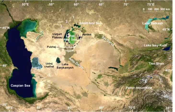
focus of international environmental concerns. The Aral Sea (Fig. 1.1) represents one of the
few Eurasian continental sites with a complete sedimentary archive that can be used for
high-resolution palaeoclimate studies. Its remote location in the continental interior of western
Asia, where different climate systems (e.g. the Subpolar Westerly Jet Stream, the Siberian
High Pressure Cell, the North Atlantic Oscillation) are interlinking, is crucial for unraveling
their respective influence on the hydrology in western Central Asia. The hydrological balance
of the endorheic Aral Sea is strongly dependent on the fluvial inputs from the Amu Darya and
the Syr Darya, its two main tributaries in the Aral Sea Basin (Fig. 1.1), which account for ca.
80% of the hydrological input into the Aral Sea. As for comparison, between 1911 and 1960,
the mean river discharge to the Aral Sea represented 56 km
3
/year (4.2 km
3
/year during 1981–
1990), while precipitation totalled only 9 km
3
/year, groundwater discharges 0–5 km
3
/year
(Jarsjö and Destouni, 2004), and the mean evaporation rate 66 km
3
/year (Zavialov, 2005). At
a regional scale, past climate variability in the arid Aral Sea Basin may be an important key
for understanding future climate change, which may affect even more drastically such arid
and semi-arid regions. Also, understanding past climate change is of great importance to
evaluate the anthropogenic impact on present-day and future climates in this highly sensitive
semi-arid region.
Figure 1.1: The Aral Sea, located in Central Asia, with the main tributaries Amu Darya and
Syr Darya, and the coring locations. 1: Tastubek Bay; 2: Tschebas Bay; 3: Chernyshov Bay.
Map extracted from NASA World Wind 1.3.
This thesis is embedded in the international collaborative research project CLIMAN
(Holocene CLImate variability and the evolution of HUMan settlement in the Aral Sea
• Determine the sequence of lake-level changes of the Aral Sea during the late
Holocene. This requires a close collaboration between geoscientists (remote
sensing), geomorphologists (field observations) and archaeologists (field
observations);
• Assess a robust chronology of climate change in the Aral Sea Basin based on a
multi-proxy approach, i.e., organic- and inorganic sediment core proxies recording
environmental change at high resolutions;
• Evaluate the underlying forcing factors regulating climate variability in the Aral
Sea Basin by comparing with other Eurasian climate records and so, searching for
atmosphere–biosphere interactions in order to improve our understanding of the
Eurasian and the Northern Hemisphere climate system;
• With climate as the dominant forcing factor, assess the history of human
adaptation in response to environmental change in Central Asia.
In this study, we mainly focus on the second and third tasks of the project CLIMAN.
Three main purposes were defined:
• Establish a reliable age model as based on AMS
14
C dating from sediment core
macroremains;
• Establish a multi-proxy dataset from biotic and abiotic proxies for reconstructing
lake-level changes and hydrological conditions in the Aral Sea, moisture
conditions in the hinterland associated with vegetation cover, and wind dynamics
determining detrital inputs in the Aral Sea Basin;
• Evaluate the main seasonal patterns of past climate variability over western
Central Asia. Climate variability in the Aral Sea Basin may highlight the climatic
affinity and possible teleconnections between Central Asia and other Eurasian
climate regimes.
Past climate variability can be reconstructed using both proxy-based correlations and
climate quantification methods. However, investigating climatic change as recorded in lake
sediments is still a challenge. One of the difficulties is to establish reliable age models for lake
sediments. Additionnally, because (i) each lacustrine environment is basically unique and (ii)
various local to regional influences may overprint primary signals, proxy records from lake
sediments must often be considered differently and transfer models must be recalibrated from
one ecosystem to the other.
I.2. Climate variability over the Eurasian continent and its influence
on Central Asia and the Aral Sea Basin
Within the global climate system, the Central Asian sector defined in this study as the area
from 30°N–55°N to 50°E–70°E in the Eurasian continent (30°N–70°N to 10°W–90°E),
constitutes an issue of particular concern within the context of regional and global climate
variability. The Asian continent exerts a strong influence on global circulation patterns, being
a region of unambiguous warming during the last decades (Hansen et al., 1988). The
dominant synoptic systems which control and determine seasonal pressure, temperature
gradients and precipitation in Asia are the Mediterranean Low-pressure Cell, the Siberian
High pressure Cell and the locally-driven surface highs (lows) during winter (summer).
The Mediterranean Low-pressure Cell
The Mediterranean basin is considered to be the most cyclogenetic area in the world
usually favouring development of weak low-pressure systems. The depressions occurring over
the Mediterranean and associated cyclonic tracks to the NE have been subject of extensive
climatological research (Alpert et al., 1990a; Chang, 1972; Karaca et al., 2000; Katsoulis,
1980; Maheras, 1983a, 1983b, 2001, Wigley and Farmer, 1982). The formation of lows over
this region in winter is associated with cold air invasion into the Mediterranean (Alpert and
Reisin, 1986; Tayanç et al., 1997; Kahana et al., 2002; Ziv et al., 2006), being connected with
positive vorticity advection at the upper levels (Kallos and Metaxas, 1980), and stems from a
thermal contrast between the cold dry air and the relatively warmer seawaters. Regions of
enhanced cyclone activity during winter and spring are the interior of the Asia Minor, the
eastern edge of the Black Sea and the Caspian Sea (Maheras et al., 2001) (Fig. 1.2).
Subsequently, maximum of precipitation is recorded during winter and spring over this area
(see Fig. 1.4i).
Figure 1.2: Low-pressure fields moving over the Middle East and western Central Asia,
The Siberian High Pressure Cell
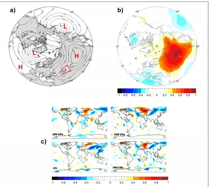
The Siberian High (SH) (Fig. 1.3) is a semi-permanent and quasi-stationary anticyclone
usually centered over northern Mongolia, but often spreads over a very large part of Asia
(Panagiotopoulos et al., 2005) including the Aral Sea Basin (Fig. 1.3a). It is the coldest and
most extensive centre of action of winter-time (October–April) general circulation of the
atmosphere (Lydolf, 1977; Sahsamanoglou et al., 1991). The SH is characterized by a
maximum in the winter mean sea-level pressure (SLP) in the Northern Hemisphere (Fig.
1.3b). However, it shows no strong relationship to other climatological SLP centers, apart a
weak negative correlation with southern Europe (Fig. 1.3b) where a stronger SH enhances
cyclogenesis in the Mediterranean region. The SH originates predominantly from the
intensive radiative cooling of the lower troposphere above the snow-covered of Asia, and its
intensity correlates closely with sea-surface temperature (Panagiotopoulos et al., 2005).
Correlation between the SH index and different wind tropospheric fields evidences that the
Aral Sea Basin is significantly influenced by the extension and strength of the SH (Fig. 1.3c).
According to Panagiotopoulos et al. (2005), significant teleconnections exist as well between
the SH and westerly jet streams on one hand, and with the winter East Asian monsoon on the
other hand as further reported from Takaya and Nakamura (2004). Its influence on the
Eurasian snow cover has been, however, controversially discussed (Clark et al., 1999; Cohen
and Entekhabi, 1999). Whereas an intensification of the SH since the 1960s has been
suggested by Mokhov and Petukhov (1999), Sahsamanoglou et al. (1991) and more recently
Panagiotopoulos et al. (2005) provided compelling information that document a clear
decreasing trend in the SH intensity during the past 30 years. According to Gillett et al.
(2003), this trend may be even strengthened in near future due to increased concentrations in
greenhouse gases.
Figure 1.3: The Siberian High Pressure Cell (modified after Panagiotopoulos et al., 2005). a:
Winter (DJF) sea-level pressure (SLP) in January averaged over 1900–2001. b: Correlation
of Siberian High index with sea-level pressure (Trenberth, 1899–2001). c: Correlation of the
SH index (mean SLP) and meridional winds at different levels of the troposphere from
NCAR/NCEP (1948–1998).
With the purpose to describe the climatology of the main climate variables for the Central
Asian sector, Figure 1.4 presents observed surface climate data for the winter and summer
temperature (a–b), global radiation (c–d), wind speed (e), number of frost / wet days per
month (f, i–j), cloud cover (g–h) and precipitation (k–l) during the second half of the 20
th
month, cloud cover and precipitation climatologies for winters (DJF) and summers (JJA)
over the Eurasian sector. a–b: Averaged land surface mean temperature 1961–1990 for
DJF and JJA, respectively (shadings, in °C); c–d: Same as a–b but for averaged global
radiation 1961–1990 (in W/m
2); e: Averaged wind speed 1961–1990 for DJF (in m/s); f:
number of frost days per month 1961–1990 for DJF; g–h: Same as a–b but for cloud
cover 1961–1990 (in %); i–j: Same as a–b but for the number of wet days per month
1961–1990; k–l: Same as a–b but for land surface precipitation 1961–1990 (in mm/day).
The data are from
http://ipcc-ddc.cru.uea.ac.uk/java/visualisation.html
. The Aral Sea
Basin (Central Asia) is marked with the red rectangle.
The winter temperatures yield a northeast to southwest divide over the Eurasian continent,
with warmer conditions in Western Europe and around the Mediterranean due to the influence
of the surrounding water masses (Fig. 1.4a). The deserts and semi-deserts of Central Asia
have a strong continental climate. The temperature pattern for winter is largely influenced by
high pressure resulting from a cold anticyclone centered over eastern and northern Asia (i.e.,
the Siberian High) with pronounced negative temperatures from 0–15°C in average up to
-40°C for the minimal values (Lioubimtseva et al., 2005). This has been often associated to a
prolonged period of freezing conditions with up to 25–30 frost days per month (Fig. 1.4f). At
the transition between winter and spring, low temperature lead to a steepening of the pressure
gradients (not shown here) which are responsible for enhanced wind dynamics (Fig. 1.4e) and
numerous dust storms in Central Asia (Orlovsky et al., 2005). The global radiation is
considerably reduced during winter as compared to the summer values (Fig. 1.4c–d), the
highest in the whole Eurasian area. In the winter precipitation sketch (Fig. 1.4k), the Atlantic
and Mediterranean region that are persistently influenced by the westerlies are wet regions.
Precipitation in the deserts of Central Asia mostly occur between December and March–April
(Fig. 1.4k). They depend highly on the position of the Siberian High and the mode of
atmospheric circulation (Aizen et al., 2001; Lioubimtseva et al., 2005; Zavialov, 2005), and
are largely controlled by shifts of the westerly cyclonic circulation. Rain is generally brought
by the depressions which develop over the Eastern Mediterranean region during winter and
spring (Maheras et al., 2001, Fig. 1.2), migrate northeastwards, and regenerate over the
Caspian Sea (Lioubimtseva, 2002; Maheras et al., 2001). This results in an enhanced cloud
cover in winter and early spring as seen in Fig. 1.4g and thus, a higher number of wet days
(Fig. 1.4j). Over the past 20 years, a net deficit in monthly precipitation has been recorded in
Western and Central Asia (Fig. 1.5). However, within the Aral Sea Basin, a great spatial
variability in precipitation trends can be observed at the landscape scale between the different
meteorological stations (Neronov, 1997), and seems to be controlled mostly by land use
changes over Central Asia are the levels of the Caspian and the Aral seas and their
contribution of moisture and heat to the lower atmosphere, especially during summer when
evaporation greatly intensifies (Lioubimtseva et al., 2005).
Figure 1.5: Monthly precipitation anomalies over Central and Southwest Asia (25°N–42°N;
42°E–70°E) for the period January 1951–September 2001. Modified after Agrawala et al.
(2001): IRI Special Report.
During summer, the climate variability and pressure gradients are weaker, as the influence
of the Siberian High diminishes. The temperature distribution yields relatively high averaged
temperatures over continental Europe, and very high temperatures over Central Asia with
values similar to those in northern Africa (25–30°C; Fig. 1.4b). Within the Aral Sea Basin, the
average July temperatures are about 32°C with a maximum of 52°C in the eastern Kara Kum
(Lioubimtseva et al., 2005). Meteorological data series show a steady increase of annual
temperatures (1–2°C) over the region during the 20
th
century (see Figs. 2–3 in Lioubimtseva
et al. (2005) for Tashkent, Repetek and Bayramaly stations). This increase is regarded as to be
the result of a decreasing influence of the southwestern periphery of the Siberian High during
winters and the intensification of summer thermal depressions over Central Asia. High
summer temperatures probably stem also from a considerably increased radiative warming
with highest values centered over the Aral Sea Basin (Fig. 1.4d). In the summer precipitation
map (Fig. 1.4l), the wettest regions correspond to the British Islands and northern Europe,
whereas the southern parts of Europe are relatively dry and influenced by the Azores
subtropical High. In Central Asia, the cloud cover (Fig. 1.4h) is considerably weakened
during summer. Coevally, precipitation are extremely low between June and August (Fig.
1.4l), resulting in a frequency of 1 to 4 wet days per month in average from 1961–1990 (Fig.
1.4j). For more details on the twentieth century climatology and current trends, we refer to
Lioubimtseva et al. (2005).
I.3. Teleconnections
To evaluate the impact of broadly recognized modes of climate variability affecting the
global system on the climatology of western Central Asia is still a challenge. NAO and ENSO
predominantly affect climate variability within Europe and the Middle East, most particularly
by determining seasonal distribution of temperature and precipitation (see Hurrell, 1995;
Hurrell & van Loon, 1997; Thompson et al., 2003; Wanner et al., 2001 and Diaz et al., 2001
for a review). Such modes of climate variability can, therefore, be expected to exert an
influence, even moderate, on the climate in Central Asia, and more likely on precipitation.
The North Atlantic Oscillation (NAO)
The impact of the NAO in the European weather system has been widely investigated
(Hurrell, 1995; 1996; Hurrell & van Loon, 1997; Hurrell et al., 2001; Ulbrich & Christoph,
1999; Ulbrich et al., 1999; Xoplaki et al., 2004). However, its influence onto the climate in
the Eastern Mediterranean (e.g. Ben-Gai et al., 2001; Eshel et al., 2000; Eshel & Farrell,
2001; Eshel, 2002; Ziv et al., 2006), the Middle East (Cullen & de Menocal, 2000; Touchan et
al., 2003) and Central Asia (Aizen et al., 2001) is still intensively discussed. During low
(negative phase) NAO winters, the sub-tropical sea-level pressure (SLP) gradient between the
Iceland Low and the Azores High is weakened and Atlantic westerlies assume a more zonal
trajectory, bringing moister and warmer conditions over the Mediterranean region (Hurrell,
1995; Hurrell & van Loon, 1997; Hurrell et al., 2001) and even further east towards the
Caspian Sea (Cullen et al., 2002). Correlation analyses between atmospheric circulation
patterns and regional-averaged precipitation showed that a negative (positive) difference in
anomalies of sea-level pressure between the Azores and the Iceland is favourable
(unfavourable) for precipitation development over the middle plains of Asia (Aizen et al.,
2001). Mann (2002) further reported that NAO-related interdecadal to centennial-scale
variability could play a principle role on the climatology of Middle Eastern regions.
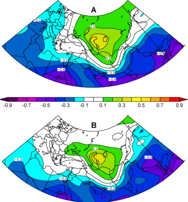
The Arctic Oscillation (AO)
The influence of the Arctic Oscillation (AO), the leading mode in the Northern
Hemisphere wintertime circulation pattern (Thompson & Wallace, 1998; 2000; Wallace &
Thompson, 2002), on climate change in Central Asia has not been thoroughly studied yet.
However, relationship between AO variability and SST and surface wind over the Middle
East during winter was evidenced by Rimbu et al. (2001) from winter time series of coral
δ
18
O record in the Red Sea. Along with strong continental conditions during a positive AO
phase, the Red Sea and EM regions receive cold and dry air from the North (see also Fig. 8d
in Aizen et al., 2001), leading to lower SST in respective areas.
Though the AO correlates strongly with the NAO (Serreze et al., 2000), the AO captures
more of the hemispheric variability than the NAO does (Mac Donald et al., 2005). The AO is,
therefore, strongly correlated with Eurasian temperatures (Thompson & Wallace, 2000). The
relationship between winter AO and 1000 h-Pa air temperature over Central Asia is indeed
strong for DJF, with R > 0.4 (significant at the 97% level) in the northern part of the Aral Sea
Basin during the period 1958–2001 (Fig. 1.6A). This may have had important consequences
on the precipitation of snow over the region during winter as for the duration of the cold
season, thus controlling the onset of snow melt during spring. An increase in the AO index is
indeed believed to result in negative snow-cover anomalies over Eurasia (Serreze et al.,
2000), as reported for the period 1972–1997 when the snow cover in Eurasia sharply declined
(Mac Donald et al., 2005). The snow-cover anomalies can in turn induce large-scale
dynamical responses and affect winter-time circulation in the Northern Hemisphere (Cohen &
Entekhabi, 2001), hence constituting feedbacks. Over half of the changes in surface air
temperature observed in Eurasia since the 1970s have been ascribed to the AO (Serreze et al.,
2000). These temperature changes are considered large enough to have an immediate effect
on polar circulation (Morison et al., 2000), and thus on the Eurasian circulation downstream
as shown on Fig. 1.6B. Correlation maps of surface and 1000 h-Pa (not shown) meridional
wind (DJF) and winter AO time series for the period 1958–2001 are in accordance with the
results of Rimbu et al. (2001). They show significant correlation (R > 0.5) over the Aral Sea
Basin, reflecting the predominant influence of the AO during winter on midlatitudes from
Central Asia. As for the air temperature correlation map above, the seasonal averaged
variables used here were extracted from the NCEP/NCAR reanalysis archive, whereas the AO
index time-series were taken from the NOAA site
http://www.cdc.noaa.gov/correlation/
.
Figure 1.6: Correlation maps of different climate variables with Arctic Oscillation (AO)
time series. A: Correlation of 1000-hPa air temperature for December–February (DJF)
(1958–2001) with December–February AO. B: Correlation of surface meridional wind for
December–February (DJF) (1958–2001) with December–February AO (extracted from
The El-Niño Southern Oscillation (ENSO)
The ENSO is recognized as a major source of global climate variability (Trenberth et al.,
1998; Diaz et al., 2001). Several authors have attempted to assess the impact of ENSO on
precipitation in the Eastern Mediterranean Sea and the Middle East (e.g. Kiladis & Diaz,
1989; Price et al., 1998), and especially in Turkey (Kadioğlu et al., 1999; Kahya & Karabörk,
2001). Within Central Asia, pionner studies which aimed to detect the influence of ENSO on
the climate were undertaken by Gruza et al. (1999). According to these authors, the ENSO
signal in Central Asia is generally weak. However, statistical relationships based on wavelet
analyses of daily observational air temperature data in the Aral Sea region reveals peaks in the
frequency spectrum of 5–6 years which can be linked with ENSO (Khan et al., 2004). The
relationship with ENSO is prominent in the northeastern part of the Aral Sea region, but much
weaker in other parts of the region.
Figure 1.7: Correlation maps of 1000-hPa geopotential height for December–February
(DJF) (1949–2005) with Southern Oscillation Index (SOI) time series. Index leads by one
month (November–January; A) and one season (September–November; B) (extracted from
NOAA site
http://www.cdc.noaa.gov/correlation/
). See text for detail.
To illustrate the connection between ENSO and different atmospheric fields within Central
Asia, we use correlation maps based on midwinter month (i.e. December–February or DJF)
averages, as the influence of ENSO on Middle Eastern climates is generally more pronounced
during winter (Kiladis & Diaz, 1989; Kadioğlu et al., 1999; Karaca et al., 2000). The monthly
/ seasonal averaged variables used in this analysis were extracted from the NCEP/NCAR
reanalysis archive (Kalnay et al., 1996; Kistler et al., 2001) and the Southern Oscillation
Index (SOI) time-series were taken from NOAA site http://www.cdc.noaa.gov/correlation/.
Regarding the study period (54 years) and assuming that the monthly / seasonal values of the
atmospheric fields are not serially correlated, any correlation of│R│> 0.3 is significant at the
97% level. Figure 1.7 represents the correlation between SOI time series and 1000-hPa gph
for the time period 1949–2003. It shows that the connection is more pronounced when a lead
time of one month (NDJ) rather than of one season (SON) is applied, with a correlation center
located over the Aral Sea basin (R > 0.3). Similar observations come up for sea-level pressure
averages calculated across the interval 1949–2005 (not shown). The correlation maps show
significant correlation (R > 0.3) over the Aral Sea Basin, reflecting the weak, but existing,
influence of ENSO during winter on midlatitudes from Central Asia.
I.4. Structure of the thesis
The thesis is written in form of three papers (Chapters III, IV and V), preceded by two
chapters setting the environmental context of this study.
Chapter II deals with a description of the coring sites where sediment cores were
retrieved, the composition and lithological properties of the studied material. Methods related
to inorganic and organic studies are briefly described. A review on previous dating obtained
on sediment cores from the Aral Sea is given and the chronology established for the present
study is explained in detail.
Chapter III is a paper published in Palaeogeography, Palaeoclimatology, Palaeoecology in
2006. It presents a high-resolution quantitative study on dinoflagellate cysts, the first one
performed in the Aral Sea. Dinoflagellate cysts assemblages were used to reconstruct the
sequence of lake-level and salinity variations both reflecting the hydrographic development of
the Aral Sea during the past 2000 years. Changes in salinity levels in the Aral Sea are linked
with changes in river run-off from the Pamir and Tien Shan moutains, reflecting temperature
reconstructions in Central Asia. The variability and remarkable events of lake-level change
are further compared with historical reviews in order to unravel the respective impact of
climate and human on the late Holocene history of environmental change in the Aral Sea.
Chapter IV is a publication accepted with revision in Quaternary Research. This chapter
deals with a quantification of climatic parameters and a reconstruction of climate variability in
the Aral Sea Basin during the late Holocene, as revealed from high-resolution pollen analyses.
The quantification of climatic parameters is assessed based on the method of the “probability
mutual climatic spheres” (PCS) method. This study allows to evidence significant changes in
moisture conditions in the Aral Sea Basin during the past 2000 years. This variability appears
to be mainly controlled by humidity brought on NE trajectories from the Mediterranean, as
inferred from comparison with other records from the Eastern Mediterranean region and the
Middle East.
Chapter V is a publication accepted with revision in Quaternary Research. It presents a
coupled high-resolution geochemical and microfacies analysis aiming to detect changes in
detrital input in the Aral Sea and its consequence on sedimentation. Effort is focused on the
identification of the forcing controlling wind dynamics and their relation with general
atmospheric circulation over Central Asia.
Chapter VI is the synthesis part. It is based first on the basis of a fourth paper
“Archaeology and Climate: Settlement and lake level change at the Aral Sea” by Boroffka et
al. (Geoarchaeology, in press) which discuss the role of human activities on the Aral Sea’s
water balance in the past based on new archaeological findings. Secondly, we expose the most
important results of this thesis and discuss what kind of forcing is basically controlling
environmental and climate change in western Central Asia during the past 2000 years.
In Chapter VII, conclusions are drawn, including a short outlook for future work.
A CD-ROM gathering dating measurements and different datasets (gamma-ray density,
magnetic susceptibility and X-ray fluorescence data performed on all sediment cores
investigated in the frame of the project CLIMAN) is joined to the thesis for data archive
Chapter II: Material and Methods – site location,
sediment properties and chronology
II.1. Coring sites: the CLIMAN summer 2002 campaign
During the CLIMAN field campaign in July/August 2002 at the northern shore of the Aral
Sea (http://climan.gfz-potsdam.de), sediment cores were retrieved at 3 different stations from
the Small and the Large Aral Sea. Site selection was determined using a preliminary seismic
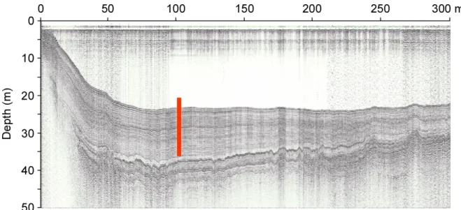
survey looking for continuous sedimentation deprived of slumping features (Fig. 2.1).
Figure 2.1: Transversal seismic profile from Chernyshov Bay showing the coring location
(N45°58’581”; E°59°14’461: Core CH1 and N45°58’528”; E°59°14’459: Core CH2) and
sediment structures.
It includes three sites offshore (Fig. 1.1): Tastubek Bay (N46°33’340”; E 60°42’298”;
TAS1), Tschebas Bay (N46°17’868”; E°59°40’040: TSC1 and N46°18’266”; E°59°38’912:
TSC2), Chernyshov Bay (N45°58’581”; E°59°14’461: CH1 and N45°58’528”; E°59°14’459:
CH2). Two types of cores were retrieved from the drilling platform. The piston coring
(
http://www.uwitec.ut
) allowed for retrieving a composite core up to 11 m in length,
consisting in sediment cores of 3 m in length with overlapping sections of about 0.5 m. This
technique, however, hampers in getting the topmost sediments. To complete the sedimentary
sequence with surface sediments, we used a gravity corer covering for the uppermost 0.5 to
0.6 m with preserved sediment top features (Kelts, 1978).
Both piston and gravity cores were used for macro- and microsedimentology,
micropalaeontology, XRF screening and radiocarbon dating (
14
C). For the thesis, though
lithological description and physical parameters measurements were performed on all
sediment cores from the 3 coring locations, we only discuss palynological and
sedimentological data gathered from the cores at Chernyshov Bay (Fig. 1.1) (CH1 and CH2),
offering the longest sedimentary sequence by far available in the Aral Sea (see Chapters III,
IV and V).
II.2. Sediment preservation and lithology
Lithological description, photographs and measurements of physical properties
(Gamma-ray density, magnetic susceptibility) were performed directly after core opening on the surface
of split core halves. Coring quality is generally good though disturbed laminations due to
coring artefacts (e.g., sea roughness during drilling) may sometimes occur. Sediment lithology
was described in detail on cores offshore from Chernyshov Bay (CH1 and CH2) (Fig. 2.2),
Tschebas Bay (TSC1 and TSC2) and Tastubek Bay (TAS1). Sediment consists mostly of
greyey silty clays and dark organic muds, occasionally with intercalated evaporites (gypsum,
salt, sometimes mirabilite) revealed from observations on smear slides. Neither erosive
discontinuity, nor features of bottom traction or turbiditic sediments were observed in the
different coring sites. Moreover, no slumps, faults, or sediments loads have been recognized.
Chernyshov Bay is situated at the northern tip of the western basin of the Large Aral Sea.
Echo sounding revealed a shallow bay that is followed by a sharp descent of the sea bottom to
a 22 m-deep basin (Fig. 2.1). The most striking feature at this location is the occurrence of a
strong pycnocline and the presence of a huge anoxic water body below it (Friedrich and
Oberhänsli, 2004), preventing sedimentation from bioturbation. Accordingly, sediments from
Chernyshov Bay show mostly well-preserved laminations. Cores CH1 and CH2 were
collected 1m apart at about 1 km from the shoreline, at a water depth of 22 m. A detailed
lithological description of Core CH1 (Fig. 2.1a), consisting in cores 21, 22, 23 [0–6.1 m] and
27, 28, 29 [6.1–11.05 m], is given in Chapter V.2.4. Core CH2 (Fig. 2.1b) consists in cores
30, 31 and 32 [0–6.2 m]. Splicing of cores 30, 31, 32 (Core CH2) and cores 27, 28, 29 with
overlaps results in the composite section CH2/1, which was investigated for high-resolution
palynological analyses.
Figure 2.2a:
Lithology of
sediment piston Cores CH1 with
coordinates. Description of
sediment colour is based upon the
colour index of the Munsell® Soil
Colour Chart. Core CH1 consists
in the splicing of cores 21, 22, 23,