HAL Id: hal-00077118
https://hal-insu.archives-ouvertes.fr/hal-00077118
Submitted on 29 May 2006
HAL is a multi-disciplinary open access
archive for the deposit and dissemination of sci-entific research documents, whether they are pub-lished or not. The documents may come from teaching and research institutions in France or abroad, or from public or private research centers.
L’archive ouverte pluridisciplinaire HAL, est destinée au dépôt et à la diffusion de documents scientifiques de niveau recherche, publiés ou non, émanant des établissements d’enseignement et de recherche français ou étrangers, des laboratoires publics ou privés.
Potential of ASAR/ENVISAT for the characterization of
soil surface parameters over bare agricultural fields
Noha Holah, Nicolas Baghdadi, M. Zribi, Ary Bruand, Christine King
To cite this version:
Noha Holah, Nicolas Baghdadi, M. Zribi, Ary Bruand, Christine King. Potential of ASAR/ENVISAT for the characterization of soil surface parameters over bare agricultural fields. Remote Sensing of Environment, Elsevier, 2005, 96, pp.(1) 78-86. �10.1016/j.rse.2005.01.008�. �hal-00077118�
Potential of ASAR/ENVISAT for the characterization of
soil surface parameters over bare agricultural fields
N. Holaha, N. Baghdadia, M. Zribib, A. Bruandc and C. Kinga
aBureau de Recherches Géologiques et Minières (BRGM) Service Aménagement et Risques
Naturels 3 Avenue C. Guillemin, B.P. 6009, 45060 Orléans cedex 2, France
bCETP/CNRS, 10/12, avenue de l'Europe, 78140 Velizy, France
cInstitut des Sciences de la Terre d'Orléans (ISTO) Université d'Orléans, Géosciences B.P.
6759 45067 Orléans cedex 2, France
Keywords: Soil moisture; Soil surface roughness; ASAR images
Abstract
The objective of this investigation is to analyze the sensitivity of ASAR (Advanced Synthetic Aperture Radar) data to soil surface parameters (surface roughness and soil moisture) over bare fields, at various polarizations (HH, HV, and VV) and incidence angles (20°–43°). The relationships between backscattering coefficients and soil parameters were examined by means of 16 ASAR images and several field campaigns. We have found that HH and HV polarizations are more sensitive than VV polarization to surface roughness. The results also show that the radar signal is more sensitive to surface roughness at high incidence angle (43°). However, the dynamics of the radar signal as a function of soil roughness are weak for root mean square (rms) surface heights between 0.5 cm and 3.56 cm (only 3 dB for HH polarization and 43° incidence angle). The estimation of soil moisture is optimal at low and medium incidence angles (20°–37°). The backscattering coefficient is more sensitive to volumetric soil moisture in HH polarization than in HV polarization. In fact, the results show that the depolarization ratio σHH0/σHV0 is weakly dependent on the roughness condition,
whatever the radar incidence. On the other hand, we observe a linear relationship between the ratio σHH0/σHV0 and the soil moisture. The backscattering coefficient ratio between a low and a
high incidence angle decreases with the rms surface height, and minimizes the effect of the soil moisture.
1. Introduction
The use of Synthetic Aperture Radar (SAR) data to retrieve soil moisture and surface roughness parameters is of considerable importance in many domains, including agriculture, hydrology, and meteorology. SAR data based on a single configuration, such as ERS-1/2 (European Remote Sensing) with VV polarization and a 23° incidence angle, and RADARSAT-1 with HH polarization and incidence angles ranging from 20° to 50°, have been used for retrieving both soil moisture and surface roughness (e.g. Baghdadi et al., 2002a, Dobson & Ulaby, 1986, Dubois et al., 1995, Fung, 1994, Le Hégarat et al., 2002, Oh et al., 1992, Srivastava et al., 2003, Ulaby et al., 1986 and Zribi & Dechambre, 2002).
The radar signal, which depends on various radar parameters (incidence angle, frequency, and polarization), is also correlated, for bare soils, with soil surface roughness and moisture content. Monitoring the evolution of surface roughness is a way of estimating erosion risk, particularly in agricultural areas. Experimental results and studies using simulation models have shown that the radar signal is more sensitive to surface roughness at high incidence angles than at low incidence angles (e.g. Baghdadi et al., 2002b, Fung & Chan, 1992 and Ulaby et al., 1986). Geng et al. (1996) and Baghdadi et al. (2003) found that HH polarization is slightly more sensitive than VV polarization to soil surface roughness.
Surface soil moisture plays a crucial role in the continental water cycle, more specifically on the distribution of precipitation between surface runoff and infiltration. Bruckler et al. (1988), based on experimental measurements on a clay loam soil and a wave propagation model, found that in the case of C-band, HH polarization, and a 15° incidence angle, the penetration depth of the radar signal decreases from about 5 cm with a soil moisture content of 10%, to 1 cm with a soil moisture content of 30%. The potential of SAR for detecting changes in surface soil moisture conditions has been demonstrated in the past (e.g. Dobson & Ulaby, 1986, Dubois et al., 1995, Fung, 1994, Geng et al., 1996, Le Hégarat et al., 2002, Le Toan, 1982 and Ulaby et al., 1986). Beaudoin et al. (1990) and Geng et al. (1996) reported that for soil moistures lower than 30–35%, the backscattering sensitivity is slightly higher for VV polarization than for HH polarization. However, the estimation of soil moisture using C–band is optimal at low incidence angles (10°–20°), with a minimum influence of soil surface roughness (Ulaby et al., 1978).
This paper investigates the sensitivity of the ASAR (Advanced Synthetic Aperture Radar) signal to soil surface parameters (soil roughness and soil moisture) at various polarizations (HH, HV, VV) and incidence angles (20°–43°). ASAR operating in the C-band (5.33 GHz) allows the acquisition of images in dual-polarization mode (two simultaneous polarizations selected from the four polarizations HH, HV, VH, and VV). In this study we also analyze the sensitivity of the depolarization ratio σHH0/σHV0 and the radar signal ratio at low and high
2. Data set
2.1. Experimental sites and ASAR data
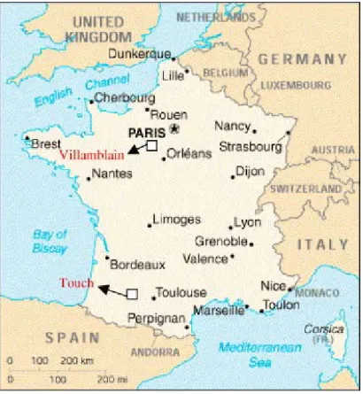
Fig. 1. Location map of the study sites.
Sixteen ASAR/ENVISAT images were acquired for several dates and different polarizations (HH, HV, and VV) with incidence angles between 20° and 43°, over two study sites (Fig. 1 and Table 1). The first study site is located at Villamblain in central France (latitude 48° 00´ N, longitude 01° 34´ E), the second is located in the Touch catchment basin in southern France, near Toulouse (latitude 43° 27.5´ N, longitude 01° 02´ E). These sites are characterized by large agricultural fields with homogenous soils composed of about 60% loam, 30% clay, and 10% sand for the first site (Macaire, 1971), and about 55% loam, 21% clay, and 24% sand for the second (CRAMP, 1995). The spatial resolution and the pixel spacing of ASAR images are about 30 × 30 m and 12.5 × 12.5 m, respectively. Absolute calibration of the ASAR images was carried out to transform the radar signal (a digital number) into a backscattering coefficient (σ0). All images were georeferenced using topographic maps with a root mean square error of the control points of about 20 m. The registration error of the ASAR images is taken into account by selecting areas of interest (AOI) within each training site and removing 2 pixels relative to the limits defined by the GPS control points. Most of the ASAR images were acquired in HH and HV polarizations; only three images were acquired in VV polarization.
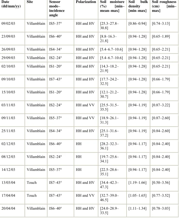
Date (dd/mm/yy) Site Sensor mode– incidence angle
Polarization Soil moisture (%) [min– mean–max] Soil bulk density [min–max] Soil roughness (cm) [min– max]
09/02/03 Villamblain IS5–37° HH and HV [25.3–27.8– 30.8]
[0.86–0.94] [0.74–3.13] 23/09/03 Villamblain IS6–40° HH and HV [8.8–16.3–
21.8] [0.94–1.28] [0.65–1.89] 26/09/03 Villamblain IS4–34° HH and HV [5.4–6.7–10.6] [0.94–1.28] [0.65–2.21] 29/09/03 Villamblain IS2–24° HH and HV [5.4–6.7–10.6] [0.94–1.28] [0.65–2.21] 02/10/03 Villamblain IS1–20° HH and HV [14.3–18.2–
21.9] [0.94–1.28] [0.65–2.21] 09/10/03 Villamblain IS7–43° HH and HV [17.7–24.2–
32.5] [0.94–1.28] [0.66–1.79] 15/10/03 Villamblain IS1–20° HH and HV [12.1–21.2–
30.7]
[0.94–1.28] [0.66–1.79] 03/11/03 Villamblain IS2–24° HH and VV [25.5–31.5–
35.5] [0.94–1.19] [0.87–3.22] 09/11/03 Villamblain IS5–37° HH and VV [18.9–26.1–
31.3] [0.94–1.19] [0.87–2.60] 25/11/03 Villamblain IS4–34° HH and HV [25.1–31.6–
37.2] [0.94–1.19] [0.84–2.60] 02/12/03 Villamblain IS6–40° HH [28.2–32.3– 36.1] [0.94–1.17] [0.84–2.40] 08/12/03 Villamblain IS2–24° HH [19.7–25.6– 34.1] [0.94–1.17] [0.84–2.40] 14/12/03 Villamblain IS5–37° HH [22.5–28.6– 35.1] [0.94–1.17] [0.84–2.40] 13/03/04 Touch IS7–43° HH and HV [34.4–42.3–
47.3] [1.19–1.66] [0.50–3.56] 17/04/04 Touch IS7–43° HH and VV [32.7–39.0–
46.5]
[1.05–1.65] [0.77–3.52] 20/04/04 Villamblain IS6–40° HH and HV [24.0–28.9–
33.5] [1.11–1.34] [0.78–3.03] Table 1. : Main characteristics of the data set used in this study: image characteristics, range of soil moisture, soil bulk density, and soil surface roughness
2.2. Experimental measurements
Simultaneously with the radar measurements, ground truth measurements of soil roughness, moisture content, and bulk density were carried out on several bare soil training sites. The number of training sites ranged from 17 to 23 for each campaign. Gravimetric soil moisture
samples were collected randomly: about 10 samples per field were taken at 0–5 cm depths. The gravimetric soil moisture content was calculated by drying the samples at 105°C for 24 h. The volumetric soil moisture (mv) was then obtained by multiplying the gravimetric soil
moisture by the bulk density. Three bulk density measurements were carried out for each training site using cylindrical samples of 500 cm3 volume and 9 cm depth. The volumetric soil moisture is obtained from:
where wwet and wdry are the wet and dry sample weights, respectively, and pb is the dry soil
bulk density. The soil moisture measurements used in this study were measured within ±2 h of the radar acquisition for most of the ASAR overpasses. The soil moisture contents range from 5.4% to 47.3% with a standard deviation of about 1.7%; the bulk densities range from 0.86 to 1.66 with a standard deviation of about 0.06. The lower values of bulk density correspond to recently tilled fields and the high values to untilled fields.
Soil roughness measurements were carried out using a pin-profiler (2 m long, 1 cm sampling interval). Ten roughness profiles were established for each training site, in two directions: parallel and perpendicular to the row direction (5 for each). It is usually assumed that the statistical properties of surface roughness conditions may be summarized using only two parameters: the root mean square (rms) surface height and the correlation length (L). The rms surface height represents the vertical variations of the surface roughness whereas the correlation length is defined as the displacement for which the autocorrelation function of the profile is equal to 1/e, Ulaby et al. (1982). After digitising the profile photographs, the rms surface height and correlation length were calculated for each training site using the mean of the ten autocorrelation functions. Soil surface roughness measurements were carried out for each date on which an ASAR image was acquired, except when no roughness change was observed. As the correlation length is the least accurate parameter and also the most difficult to measure, we decided not to use it in this study. Based on simulations, Oh and Kay (1998) showed that correlation length measurements are unreliable when conventional profilometers of 1 or 2 m long are used (error over 50%), whereas the accuracy associated with the rms is of the order of 15%.
The rms values, which depend on the type of agricultural activity, fluctuate in this study between 0.5 cm and 3.56 cm, with the lower values mainly corresponding to sown fields and the higher values to recently ploughed fields. The contours of training sites were determined using GPS points and SPOT images acquired in 2003. The mean backscattering coefficient (σ0) was then calculated for each training site using all the pixels within the training site.
3. Results and discussion
3.1. Relationship between backscattering coefficient and surface roughness
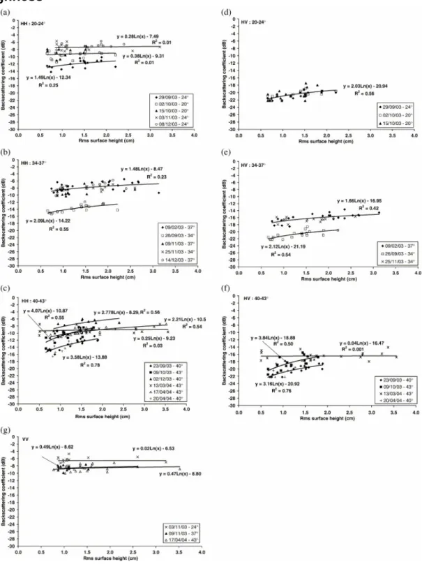
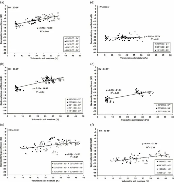
Fig. 2. Variations of the backscattering coefficient in HH and HV polarizations as a function of rms surface height for three ranges of incidence angle: (a) HH: 20°–24°, (b) HH: 34°–37°, (c) HH: 40°–43°, (d) HV: 20°– 24°, (e) HV: 34°–37°, and (f) HV: 40°–43°. The line represents the best fit of the experimental points.
In order to analyze the behavior of the ASAR signal as a function of the surface roughness, the backscattering coefficient (σ0) was plotted for all data, independent of soil moisture. We have classified the ASAR images into three groups of incidence angle: (1) low incidence angle: 20°–24°, (2) medium incidence angle: 34°–37°, and (3) high incidence angle: 40°–43°. For each group, Fig. 2 shows the relationship between the backscattering coefficient and the rms surface height for HH, HV, and VV polarizations.
The results show that the backscattering coefficient for HH and HV polarizations increases with the rms surface height. The radar signal is more sensitive to surface roughness at high incidence angles, as suggested by Baghdadi et al. (2002b). The dynamics of the radar signal, which are the same for HH and HV polarizations, are weak for rms between 0.5 and 3.56 cm: about 1 dB for incidence angles between 20° and 24°, 2 dB for incidence angles between 34° and 37°, and 3 dB for incidence angles between 40° and 43°.
In VV polarization, the backscattering coefficient is weakly dependent on the rms surface height whatever the incidence angle (24°, 37°, and 43°: Fig. 2g). The results show that the HH and HV polarizations are more sensitive than the VV polarization to surface roughness. Many studies have reported similar results (e.g. Baghdadi et al., 2003, Fung, 1994 and Geng et al., 1996). Under very wet conditions, at soil moistures greater than 35% (13 March and 17 April 2004), the backscattering coefficient becomes almost independent of the surface roughness for all polarizations (Fig. 2c, f and g).
With HV polarization and low incidence angles (20°–24°), the results show a weak correlation between radar signal and surface roughness (Fig. 2d). In practice, the backscattering coefficients for ASAR images acquired at different dates are similar in magnitude for all soil moisture levels.
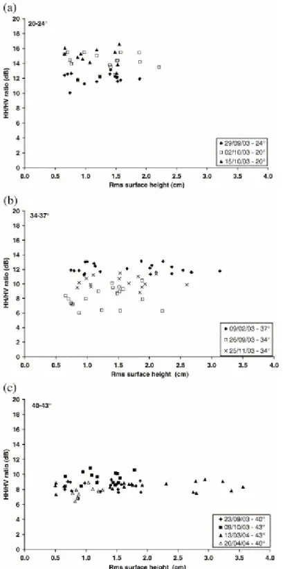
Fig. 3 presents the values of the depolarization ratio σHH0 / σHV0 in terms of the rms surface
height for the three groups of incidence angle. This ratio shows no significant dependence on the roughness condition, whatever the radar incidence. The ratio σHH0/σHV0 decreases with the
incidence angle.
3.2. Relationship between backscattering coefficient and soil moisture
The backscattering coefficient was plotted as a function of soil moisture for all data, whatever the rms surface height. For each group of incidence angles, Fig. 4 shows a linear relationship between the soil moisture and the backscattering coefficient in HH and HV polarizations. In VV polarization, owing to the lower range of moisture content (only 10%) for each group of incidence angles, no relationship could be established between the radar signal and the soil moisture.
Fig. 3. Relationships between the depolarization ratio HH/HV and the rms surface height (a): 20°–24°, (b): 34°– 37°, and (c): 40°–43°. The line represents the best fit of the experimental points.
Fig. 4. Relationships between the backscattering coefficient in HH and HV polarizations and the volumetric moisture content in the top 0–5 cm of soil depth for three ranges of incidence angle: (a) HH: 20°–24°, (b) HH: 34°–37°, (c) HH: 40°–43°, (d) HV: 20°–24°, (e) HV: 34°–37°, and (f) HV: 40°–43°. The line represents the best fit of the experimental points.
In fact, the backscattering coefficient increases with the volumetric soil moisture for values between 5% and 35%. For an incidence angle of 20°–24°, the sensitivity of the radar signal to soil moisture is higher in HH polarization than in HV polarization (0.18dB/% and 0.02dB/%, respectively). The results show that in HH polarization, sensitivity increases slightly when the incidence angle rises from 20°–24° to 34°–37° (from 0.18 to 0.22), and decreases to 0.12 for incidence angles of 40°–43°. In HV polarization, sensitivity increases significantly from 20°– 24° to 34°–37° (0.02dB/% and 0.17dB/%). For an incidence angle of 40°–43°, the difference in sensitivity between HH and HV polarizations is minor (of the order of 10%).
Geng et al. (1996) reported that the slope of the regression between the radar signal, in C-band and for an incidence angle of 55°, and the soil moisture is higher for HH polarization than for HV polarization. Other studies found that the sensitivity of the radar signal to soil moisture is lower in HH polarization than in HV polarization for an incidence angle between 20° and 30° (e.g. Hirosawa et al., 1978, Hirosawa et al., 1980, Kobayashi & Hirosawa, 1984, Le Toan, 1982 and Ulaby et al., 1978).
For very wet soils (soil moisture greater than 35%), the radar signal does not seem to increase linearly with the soil moisture (Fig. 4b, c, e and f). In fact, the backscattering coefficient remains constant with increasing volumetric soil moistures. This result has been observed in many studies (e.g. Bruckler et al., 1988, Chanzy, 1993 and Dobson & Ulaby, 1981).
We observe a higher dispersion of measurement points for the ASAR data at high incidence angles (40°–43°): this dispersion is due to the strong influence of the surface roughness parameter (Fig. 4c and f). We conclude that the estimation of volumetric soil moisture is better at low and medium incidence angles, with a minimum influence of soil surface roughness, than at high incidence angles.
Fig. 5 presents the ratio σHH0/σHV0 in terms of the volumetric soil moisture for the three
groups of incidence angles. We observe a linear relationship between the radar signal and the volumetric soil moisture. The sensitivity of the signal decreases with the incidence angle, while at high incidence angles (40°–43°) the ratio becomes almost independent of the volumetric soil moisture (Fig. 5c).
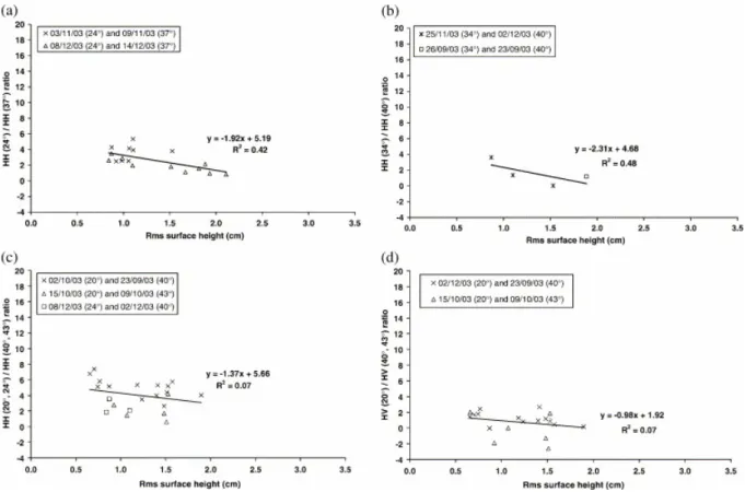
3.3. Behavior of the signal ratio at two incidence angles
The comparison of ASAR images acquired at two different incidence angles (low and high) and with the same polarization has been studied to analyze the dependence of the backscattering coefficient ratios (in dB) on soil moisture and rms surface height. However, with the ASAR sensor, it is not possible to obtain images with two incidence angles simultaneously. Therefore the only images used were those acquired on closely spaced dates (less than 10 days apart) and exhibiting the same roughness conditions and soil moistures. No corrections were applied to the backscattering coefficients to take into account the small variations in soil moisture and surface roughness that occurred between the two dates of acquisition. Only training sites having a soil moisture variation of less than 5% between the two dates of acquisition were used. Fig. 6 and Fig. 7 present the backscattering coefficient ratios HHlow-incidence/HHhigh-incidence and HVlow-incidence/HVhigh-incidence for rms surface height and
volumetric soil moisture, respectively. The results show that the backscattering coefficient ratio HHlow-incidence/HHhigh-incidence decreases with the rms surface height. Similarly, the
backscattering coefficient ratio HVlow-incidence/HVhigh-incidence seems to decrease with the rms
surface height. We note that the sensitivity of the ratio HVlow-incidence/HVhigh-incidence for rms
surface height is lower than that of the ratio HHlow-incidence/HHhigh-incidence. On the other hand,
the ratios HHlow-incidence/HHhigh-incidence and HVlow-incidence/HVhigh-incidence are independent of the
soil moisture. These conclusions are in accordance with the work of Autret et al. (1989), Oh et al. (1992), Srivastava et al. (2003), and Zribi and Dechambre (2002).
Fig. 5. Relationships between the depolarization ratio HH/HV and the volumetric soil moisture (a): 20°–24°, (b): 34°–37°, and (c): 40°–43°. The line represents the best fit of the experimental points.
Fig. 6. Relationships between the ratio HHlow-incidence/HHhigh-incidence and HVlow-incidence/HV high-incidence as a function of rms surface height.
Fig. 7. Relationships between the ratio HHlow-incidence/HHhigh-incidence and HVlow-incidence/HV high-incidence as a function of soil moisture.
4. Conclusions and further work
The objective of this study was to analyze the behavior of ASAR signal as a function of surface roughness and soil moisture over bare fields. For HH and HV polarizations, the sensitivity of the backscattering coefficient to surface roughness increases with the incidence angle but the difference between the backscattering coefficient for low and high surface heights is minor. For VV polarization, the backscattering coefficient is weakly dependent on the rms surface height. The results show that HH and HV polarizations are more sensitive than VV polarization to surface roughness. The high-incidence angle (40°–43°) ASAR images are the most suitable for discriminating between the various roughness conditions, with a minimum influence of soil moisture. The sensitivity of the ASAR signal to surface roughness in an agricultural setting would enable the mapping of bare soils according to two or three roughness classes (smooth, moderate and rough surfaces). When the soil becomes very wet (soil moisture greater than 35%) the backscattering coefficient becomes independent of the surface roughness for both HH and HV polarizations.
We note that the backscattering coefficient with HH polarization is more sensitive to soil moisture than with HV polarization. The mapping of soil moisture using the ASAR data will be optimal at low and medium incidence angles (20°–24° and 34°–37°), with a minimum influence of roughness parameters, in contrast with high incidence angles (40°–43°). For very wet soil, the radar signal remains constant with increasing volumetric soil moisture for HH and HV polarizations.
The results indicate that the depolarization ratio σHH0/σHV0 is weakly dependent on the
roughness condition, whatever the radar incidence. On the other hand, we observe a linear relationship between the ratio σHH0/σHV0 and the volumetric soil moisture. The slope of this
relationship decreases with the incidence angle. However, at high incidence angles (40°–43°), the ratio becomes independent of the soil moisture. Furthermore, the ratios HH low-incidence/HHhigh-incidence and HVlow-incidence/HVhigh-incidence decrease with rms surface height and are
independent of soil moisture. The combined use of HH and HV polarizations instead of one alone would not help in acquiring surface parameters, although SAR data at low and high incidence angles would be useful for estimating soil parameters. Unfortunately, it is not possible to acquire ASAR images with both low and high incidence angles simultaneously. Other ASAR images at different incidence angles and in VV polarization are required to better analyze the behavior of the backscattering coefficient as a function of surface roughness and soil moisture.
Acknowledgements
This work was jointly financed by the BRGM (French Geological Survey), the PNTS (French Remote Sensing Program), and the PNRH (French Hydrological Program, RIDES project). The authors would like to thank the European Space Agency (ESA) for providing the ASAR images free of charge through ENVISAT/ASAR project No. 351. The SPOT images were acquired through the CNES (Centre National d’Etudes Spatiales) ISIS program . The authors would also like to thank Steven Hosford, Odile Duval, Olivier Cerdan, Monique Dechambre, Catherine Ottlé, and Christine Guérin for their logistic support during the field campaigns.
References
Autret et al., 1989 M. Autret, R. Bernard and D. Vidal-Madjar, Theoretical study of the sensitivity of the microwave backscattering to the soil surface parameters, International
Journal of Remote Sensing 10 (1989) (1), pp. 171–179.
Baghdadi et al., 2002a N. Baghdadi, S. Gaultier and C. King, Retrieving surface roughness and soil moisture from synthetic aperture radar (SAR) data using neural networks, Canadian
Journal of Remote Sensing 28 (2002) (5), pp. 701–711
Baghdadi et al., 2002b N. Baghdadi, C. King, A. Bourguignon and A. Remond, Potential of ERS and Radarsat data for surface roughness monitoring over bare agricultural fields: Application to catchments in Northern France, International Journal of Remote Sensing 23 (2002) (17), pp. 3427–3442
Baghdadi et al., 2003 N. Baghdadi, L. Bonnifait, C. King and A. Bourguignon, Utilisation des images SAR pour la calibration empirique du modèle IEM dans un contexte de sols nus en zones agricoles, Revue de Télédétection 3 (2003) (1), pp. 1–16.
Beaudoin et al., 1990 A. Beaudoin, Q.H.J. Gwyn and T. Le Toan, SAR observation and modelling of the C-band backscatter variability due to multi-scale geometry and soil moisture,
IEEE Transactions on Geoscience and Remote Sensing 28 (1990) (5), pp. 886–894.
Bruckler et al., 1988 L. Bruckler, H. Wittono and P. Stengel, Near surface moisture estimation from microwave measurements, Remote Sensing of Environment 26 (1988), pp. 101–121. Chanzy, 1993 A. Chanzy, Basic soil surface characteristics derived from active microwave remote sensing, Remote Sensing Reviews 7 (1993), pp. 303–319.
CRAMP, 1995 CRAMP (Chambre Régionale d’Agriculture de Midi-Pyrénées), Les grandes
ensembles morpho-pédologiques de la région Midi-Pyrénées (1995).
Dobson & Ulaby, 1981 M.C. Dobson and F.T. Ulaby, Microwave backscatter dependence on surface roughness, soil moisture and soil texture: Part III—Soil tension, IEEE Transactions
on Geoscience and Remote Sensing 19 (1981), pp. 51–61.
Dobson & Ulaby, 1986 M.C. Dobson and F.T. Ulaby, Active microwave soil moisture research, IEEE Transactions on Geoscience and Remote Sensing 24 (1986) (1), pp. 23–36. Dubois et al., 1995 P. Dubois, J.J. Van Zyl and T. Engman, Measuring of soil moisture with imaging radars, IEEE Transactions on Geoscience and Remote Sensing 33 (1995), pp. 915– 926.
Fung & Chan, 1992 A.K. Fung and K.S. Chan, Dependence of the surface backscattering coefficients on roughness, frequency and polarization states, International Journal of Remote
Sensing 13 (1992), pp. 1663–1680.
Fung, 1994 A.K. Fung, Microwave scattering and emission models and their applications, Artech House, Inc., Boston, London (1994) 573 pages.
Geng et al., 1996 H. Geng, Q.H.J. Gwyn, B. Brisco, J. Boivert and R.J. Brown, Mapping of soil moisture from C-band radar images, Canadian Journal of Remote Sensing 22 (1996) (1), pp. 117–126.
Hirosawa et al., 1978 H. Hirosawa, S. Komiyama and Y. Matsuzaka, Cross-polarized radar backscatter from moist soil, Remote Sensing of Environment 7 (1978), pp. 211–217.
Hirosawa et al., 1980 H. Hirosawa, S. Komiyama and Y. Matsuzaka, Active microwave remote sensing by using circular polarization, Proc. 31st Congress Int. Astronautical
Federation, IAF-80-B-97, Tokyo, 21–28 September, Pergamon Press (1980).
Kobayashi & Hirosawa, 1984 T. Kobayashi and H. Hirosawa, Measurements of radar backscatter from rough soil surface by using linear and circular polarization, Int. Symp.
Microwave Signatures in Remote Sensing, URSI Commission F, Toulouse, France, 16–20 January (1984).
Le Hégarat et al., 2002 S. Le Hégarat, M. Zribi, F. Alem, A. Weisse and C. Loumagne, Soil moisture estimation from ERS/SAR data: Toward an operational methodology, IEEE
Transactions on Geoscience and Remote Sensing 40 (2002) (12), pp. 2647–2658.
Le Toan, 1982 T. Le Toan, Active microwave signatures of soil and crops. Significant results of three years of experiments, Proceeding of the International Geoscience and Remote
Sensing Symposium, IGARSS 82, held in Munich, F.R. Germany, on 1–4 June 1982, IEEE,
New York (1982), pp. 25–32.
Macaire, 1971 Macaire, J.M.(1971). Etude sédimentologique des formations superficielles sue le tracé de l’autoroute A10 entre Artenay et Meung/Loire. Thèse 3e cycle Université d’Orléans, 104 pp.
Oh et al., 1992 Y. Oh, K. Sarabandi and F.T. Ulaby, An empirical model and an inversion technique for radar scattering from bare soil surfaces, IEEE Transactions on Geoscience and
Remote Sensing 30 (1992), pp. 370–381.
Oh & Kay, 1998 Y. Oh and Y. Kay, Condition for precise measurements of soil surface roughness, IEEE Transactions on Geoscience and Remote Sensing 36 (1998) (2), pp. 691– 695.
Srivastava et al., 2003 H.S. Srivastava, P. Patel, M.L. Manchanda and S. Adiga, Use of multiincidence angle of radarsat-1 SAR data to incorporate the effect of surface roughness in soil moisture estimation, IEEE Transactions on Geoscience and Remote Sensing 41 (2003) (7), pp. 1638–1640.
Ulaby et al., 1978 F.T. Ulaby, P.B. Baltivala and M.C. Dobson, Microwave backscatter dependence on surface roughness, soil moisture and soil texture: Part 1—Bare soil, IEEE
Transactions on Geoscience and Remote Sensing GE-16 (1978) (4), pp. 286–295.
Ulaby et al., 1982 F.T. Ulaby, R.K. Moore and A.K. Fung, Microwave remote sensing, active and passive, Radar Remote Sensing and Surface Scattering and Emission Theory vol. 2, Addison–Wesley, New York (1982), pp. 822–825.
Ulaby et al., 1986 F.T. Ulaby, R.K. Moore and A.K. Fung, Microwave remote sensing, active and passive, Volume Scattering and Emission Theory—Advanced Systems and Applications
vol. 3, Artech House, Inc., Dedham, Massachusetts (1986) 1098 pages.
Zribi & Dechambre, 2002 M. Zribi and D. Dechambre, A new empirical model to retrieve soil moisture and roughness from C-band radar data, Remote Sensing of Environment 84 (2002), pp. 42–52.