HAL Id: hal-01805164
https://hal.archives-ouvertes.fr/hal-01805164
Submitted on 2 Feb 2021
HAL is a multi-disciplinary open access
archive for the deposit and dissemination of
sci-entific research documents, whether they are
pub-lished or not. The documents may come from
teaching and research institutions in France or
abroad, or from public or private research centers.
L’archive ouverte pluridisciplinaire HAL, est
destinée au dépôt et à la diffusion de documents
scientifiques de niveau recherche, publiés ou non,
émanant des établissements d’enseignement et de
recherche français ou étrangers, des laboratoires
publics ou privés.
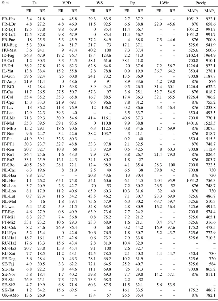
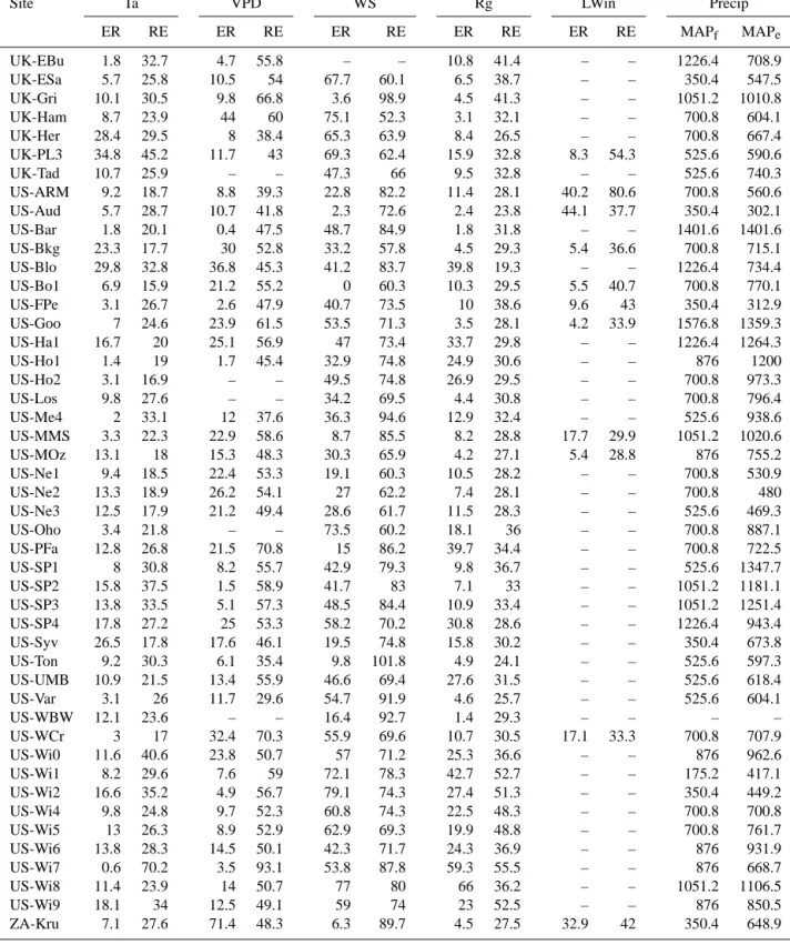
Filling the gaps in meteorological continuous data
measured at FLUXNET sites with ERA-Interim
reanalysis
N. Vuichard, D. Papale
To cite this version:
N. Vuichard, D. Papale. Filling the gaps in meteorological continuous data measured at FLUXNET
sites with ERA-Interim reanalysis. Earth System Science Data, Copernicus Publications, 2015, 7 (2),
pp.157 - 171. �10.5194/essd-7-157-2015�. �hal-01805164�
Earth Syst. Sci. Data, 7, 157–171, 2015
www.earth-syst-sci-data.net/7/157/2015/
doi:10.5194/essd-7-157-2015
© Author(s) 2015. CC Attribution 3.0 License.
Filling the gaps in meteorological continuous data
measured at FLUXNET sites with ERA-Interim reanalysis
N. Vuichard
1and D. Papale
2,31
Laboratoire des Sciences du Climat et de l’Environnement, LSCE/IPSL – UMR CEA/CNRS/UVSQ 8212
CEA Saclay, Orme des Merisiers, Bât 712, 91191 Gif-sur-Yvette, France
2
Department for Innovation in Biological, Agro-food and Forest systems (DIBAF), University of Tuscia,
Viterbo, Italy
3
Euro-Mediterranean Center on Climate Change (CMCC), Via Augusto Imperatore 16, 73100 Lecce, Italy
Correspondence to: N. Vuichard (vuichard@lsce.ipsl.fr)
Received: 28 November 2014 – Published in Earth Syst. Sci. Data Discuss.: 20 January 2015 Revised: 22 June 2015 – Accepted: 23 June 2015 – Published: 13 July 2015