DEVELOPMENT OF A PLANNING PROCESS MODEL FOR IMPLEMENTATION OF NEOTRADITIONAL TOWN PLANNING PRINCIPLES IN EXISTING COMMUNITIES
by Stacy M. Heen B.S. Art and Design
Massachusetts Institute of Technology, 1995
SUBMITTED TO THE DEPARTMENT OF URBAN STUDIES AND PLANNING IN PARTIAL FULFILLMENT OF THE REQUIREMENTS FOR THE DEGREE OF
MASTER OF CITY PLANNING AT THE
MASSACHUSETTS INSTITUTE OF TECHNOLOGY June 1996
@1996 Stacy Heen. All rights reserved.
The author hereby grants to MIT permission to reproduce and to distribute publicly paper and electronic copies of this thesis document
in whole or in part.
,---) 'a 1 /
Signature of A uthor:... - . . ... Department of Urban S dies and Planning
May 16, 1996 C ertified b y :.../ ... ... Terry Szold Lecturer Thesis Supervisor AA A ccep ted b y :. ... ...
J.
Mark SchusterAA UE TS NS uChairman, Master of City Planning Committee
OF TECHNOLOGY
JUL 0
21996
gote LIBRARIESDEVELOPMENT OF A PLANNING PROCESS MODEL FOR IMPLEMENTATION OF NEOTRADITIONAL TOWN PLANNING PRINCIPLES IN EXISTING COMMUNITIES
by Stacy M. Heen
Submitted to the Department of Urban Studies and Planning
on May 16, 1996 in Partial Fulfillment of the Requirements for the Degree of Master of City Planning
ABSTRACT
Developers from Florida to California are building Traditional Neighborhood Developments (TND's) based on the ideals embedded in the New Urbanism. Andres Duany, an architect who helped introduce the concept, has even claimed that it will become the next model for the American suburb.
This claim, however, highlights one of the major limitations of the neotraditional model: to date, most TND projects have been located in suburban and exurban areas. And critics assert that "unless its planning ideals are implemented more widely, they could become little more than a collection of architectural cliches, rather than a working set of principles for reshaping metropolitan areas and guiding future growth."1
Recent experimentation with TND principles in already urbanized areas shows that it can indeed be implemented more widely. However, such projects are few and far between and are considered anomalies. To facilitate the broader use of neotraditional principles in urban areas, this thesis analyzes the experience of four cities that have already incorporated TND principles. The analysis includes consideration of the 1) key players and their roles, 2) planning and design processes, and 3) implementation tools
and strategies each community employed.
From this analysis, this thesis develops a TND Planning Process Model. Ultimately, the Model is not necessarily unique to the New Urbanism. But the lessons learned from the case studies and the extraction of specific tools and strategies from each city's experience are intended to offer guidance for other communities considering the incorporation of neotraditional design principles.
Thesis Supervisor: Terry Szold Title: Lecturer
1 Lloyd Bookout, "Neotraditional Town Planning: Toward a Blending of Design Approaches," Urban Land, August 1992, p. 18.
TABLE OF CONTENTS
A BSTRA CT ... 3
LIST O F FIG U R ES A N D TA BLES ... 7
A CK N O W LED G M EN TS... 9
CH A PTER 1: IN TR O D U CTIO N ... 11
The Popularity of Neotraditional Town Planning...11
M odern D evelopm ent Patterns ... 12
The N eotraditional M odel... 15
Criticism s of N eotraditional Tow n Planning ... 18
A ddressing the Criticism s... 21
The Research Process ... 23
O rganization of Thesis... 26
CH A PTER 2: TH E CA SE STU D IES... 27
A Planning Process Fram ew ork ... 27
M ercer Island, W ashington ... 29
Providence, Rhode Island ... 32
San Jose, C alifornia... 37
Suisun C ity, C alifornia... 40
Sum m ary...43
CH A PTER 3: A N A LYSIS ... 44
K ey Players and Their Roles ... 45
D iscussion...53
Planning and D esign A ctivities... 56
D iscussion...59
Im plem entation Tools... 60
D iscussion...63
Sum m ary...65
CHAPTER 4: THE TND PLANNING PROCESS MODEL ... 69
N ecessary Players and Roles ... 69
Suggested Planning and D esign A ctivities... 72
A n Im plem entation Toolbox... 74
CH A PTER 5: C O N C LU SIO N S... 77
BIBLIO G RA PH Y ... 83
LIST OF FIGURES AND TABLES
Figure 1: Plan of Seaside... 16
Figure 2: Mercer Island Illustrative TND Plan... 32
Figure 3: Providence TND Regulating Plan... 36
Figure 4: Jackson-Taylor Illustrative TND Plan...39
Figure 5: Suisun City Illustrative TND Plan... 41
Figure 6: Linear Representation of Planning Activities... 57
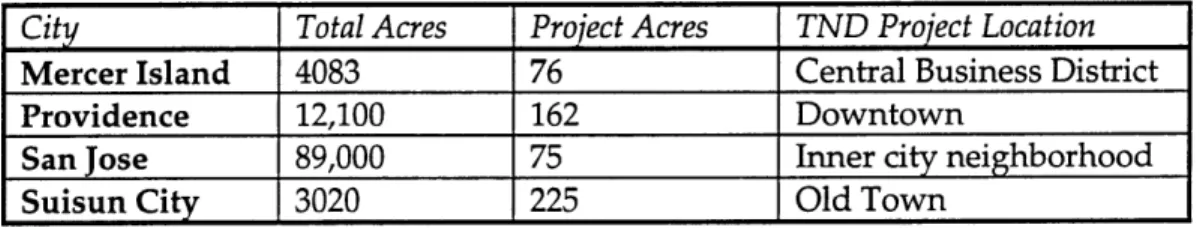
Table 1: Size and Location of TND projects... 29
ACKNOWLEDGMENTS
I would like to thank my advisor, Terry Szold, for her invaluable advice during the conceptualization and writing stages of this thesis. Her focused and strategic suggestions greatly improved the quality of my work.
I am also grateful to my willing interviewees. Despite my abrupt (and rather last-minute) requests for their time, all of them cheerfully provided me with information and insights into their community's planning process. Any factual mistakes or misinterpretations of their experiences are mine alone.
I am thankful to my family and friends for providing moral support during the past several months. I owe a substantial debt to Kaye Yoshino, who willingly took the time out of her journal reading and Legal Research work to read (and reread) my drafts. Her encouragement and perspective were especially needed. And I really appreciate Sheila's willingness to do final proof-reading with such little notice. Her comments tightened my writing a great deal.
Ultimately, I am thankful to God for giving me the strength and perseverance to finish this thesis. I must say, having the right perspective on my work (and life) has done amazing things for my stress level and overall sanity. I highly recommend it.
CHAPTER
1:
INTRODUCTION
This chapter addresses several aspects of Neotraditional Town Planning. The first two sections discuss the growing popularity of the New Urbanism and trace its evolution from a dissatisfaction with postwar development patterns. The following three sections explain the vision of the Traditional Neighborhood Development (TND) model, its criticisms, and its potential. The fifth section traces the evolution of this research project and discusses the need for a systematic planning process model for the TND concept.
THE POPULARITY OF NEOTRADITIONAL TOWN PLANNING
Neotraditional Town Planning, introduced in 1981 with the unveiling of the resort town of Seaside, Florida, has become an increasingly popular development strategy during the past fifteen years. The ever-growing bibliography of relevant literature belies a tremendous interest in the so-called New Urbanism -- one which spans several professions. The concept has been the subject of discussion among architects, planners, social commentators, practitioners, economists, theorists, students and teachers alike. It has been the focus of planning conferences and the subject of articles in the popular media and urban journals. It has also motivated several theses.
Seaside has proven to be a powerful hallmark of the neotraditional vision. Developers, seeing the economic potential of the idea embodied in Seaside, have launched dozens of neotraditional projects from Florida to California. Kentlands, Maryland, and Peter Calthorpe's Laguna West, California are among
the most widely recognized TND communities.2 Haymount, an
"environmentally responsible" development underway in Virginia, has also received much press attention.3
2 Calthorpe's approach is slightly different from the Duany/Plater-Zyberk model in that it is oriented around public-transit and is termed a "pedestrian pocket."
3 See, for example: Vernon Mays, "Haymount, a Brave Old World," Inform, 1995, No. 2.; Philip
Proponents believe that the TND model represents a new development paradigm. Andres Duany, architect and designer of Seaside, contends: "Seaside has no enemies. Developers like it: It's profitable. Residents love it. I think it's going to be the next model for the American suburb. Within ten years, it will be the next model. All developers will want to copy it. I don't think it will be too ambitious to say that."4 Certainly the amount of attention that the New
Urbanism has received gives Duany's assertion a certain amount of credibility. At the same time, such a bold statement necessitates closer examination of the merits and critiques of the neotraditional concept. What is the New Urbanism and what are its goals?
MODERN DEVELOPMENT PATTERNS
Proponents of the TND model base their arguments largely on the negative impacts of modem development patterns. This pattern of sprawl is most commonly associated with postwar suburban development.
The widespread decentralization of people, goods, and services began when the federal government encouraged GIs returning from World War II to buy homes in new communities at the fringes of metropolitan areas. Armed with subsidized mortgages, veterans and their families streamed into mass produced subdivisions like Levittown, New York. Such communities thrived, at least in part, because they were economically efficient and provided the opportunity for home ownership.
Journal, December 9, 1994; "Planning News," Planning, February 1995; Michael Leccese, "Suburbs with Soul," USA Weekend, September 16, 1994; John A. Clark and Daniel K. Slone, "Haymount and the Developer's Lament," National Wetlands Newsletter, March-April 1995; and James A. Bacon, "The Road to Haymount," Virginia Business, April 1991.
4 John Dorschner, "Back to the Future," Tropic: The Miami Herald Sunday Magazine, Feb. 21,
The "American dream" of owning a single-family home accelerated the construction of thousands of outlying residential communities like Levittown. Easy credit for automobiles and generous federal government mortgage policies facilitated this trend;5 this post-war exodus from central cities continued for four decades. As of the late 1980's it was estimated that 45% of Americans were suburbanites.6
In the early stages of this decentralization, suburbanites depended on central cities for employment, retail, and cultural needs. But the burgeoning population of suburban communities demanded closer, more convenient services. Retailers and other commercial outfits responded by relocating to the suburban areas. Then, in the 1980's, employers began to move to the outer reaches of metropolitan regions. Today, another iteration of decentralization is underway as residents have begun to leave these "edge cities" to live even farther out in the countryside. This pattern is evidenced by discussion among urbanists of exurbs, the "suburb's suburb."7
Neotraditional supporters have a negative view of suburban sprawl. Developer John Clark asserts, in fact, that "the post-war North American suburb is a model of social and economic segregation."8 Indeed, the economic and racial homogeneity of most suburban communities is not representative of the diversity of the American population. But perhaps more central to the argument of neotraditionalists is their assertion that suburbs have caused "a wholesale transformation of American metropolitan life, in which traditional concepts of
5 "Planning Portfolio," in Frank S. So and Judith Getzels, Eds., The Practice of Local Government Planning, p. 451.
6 "Population Profile of the United States 1984/85," Bureau of the Census, Washington D.C.:
April 1989. Special Studies, Series P-23, No. 150, p. 14.
7 John V. Moeser, "Alternative Perspectives on Edge City," APA Journal, Summer 1992, 391.
8 John A. Clark, Architecture, Ethics & the Environment: An Exploration of Nature & the Human
community, civic place, and neighborhood have been either overrun or severely threatened."9
The "traditional" notion of community is a place-dependent idea that social connections are made through the people closest to you and in the places you frequent. At least, this seems to have been the historical pattern in most parts of the world. Today, however, with the mobility afforded by advances in transportation and information technology, Americans' social connections are often made through other channels such as school, work, or hobbies. High turnover rates and a general suspiciousness of strangers hinder suburbanites' ability and desire to get to know their neighbors.
On one hand, it could be argued that the built environment of the suburbs merely reflects the reduced role that "place" plays in the social lives of its residents. But neotraditionalists believe that the built environment discourages
--actually, disallows -- meaningful social interaction. Their argument is based on
two specific aspects of suburban sprawl: the postwar change in street layout and increasingly strict zoning laws.
After World War II, planners and transportation engineers began to employ a hierarchical system of arterials, collectors, and local streets reminiscent of the Radburn, New Jersey layout. This hierarchical pattern had several benefits. For engineers, limited access roadways were more efficient because they accommodated higher volumes of high speed traffic. Collector streets channeled through traffic away from neighborhoods, which reduced the risk of pedestrian-automobile collisions. From the developer's point of view, a systematic grid layout required more concrete than curvilinear streets and cul-de-sacs; as a result, cul-de-sacs were less costly to build. Given these economic and safety concerns, the curvilinear pattern eventually replaced the typical grid layout that had characterized the streetcar suburbs of the early 1900's. In today's suburbs,
collector streets as wide as 75 feet are common. Aside from safety concerns, pedestrian activity and inhabitation of the public realm are often discouraged by the sheer physical scale of the street.
Increasingly strict Euclidian zoning laws are the second major reason the suburbs lack a lively social environment. Enacted during the Industrial Age because of the health and safety threats that factories posed for nearby residents, these zoning laws mandated the separation of residential, commercial, and industrial uses. Euclidian zoning ordinances mandating the separation of uses and low densities continued to get stricter even after industry declined in this country. They remained for several reasons. For example, Americans seem to prefer separating their public and private lives. Higher stress levels in the workplace and the perception of rising crime in both cities and suburbs have contributed to the desire to "get away" from it all and retreat to the safety and sanctity of the home at the end of the day. Suburban residential neighborhoods are often spatially segregated from services and employment centers in a deliberate effort to isolate the private realm. Second, as Clark noted, "the increasing specialization required by a technologically based society has had the effect of fragmenting our civilization."10 In other words, the economics of specialization has led to a pattern of locating similar business activities in similar areas. High tech industries, for example, tend to be spatially segregated employment centers, usually far removed from residential and civic activities.
THE NEOTRADITIONAL MODEL
The spatial segregation of activities in the suburbs and the perceived social isolation of such places spurred neotraditionalists to propose a different way of building suburbs. Neotraditionalists assert that many of the ills of modern suburbs can be eliminated by returning to the kinds of places where people know one another and walk to the center of town to buy a gallon of milk at the corner store: small towns.
Figure 1: Plan of Seaside
Early 20th century American towns became a prototype for the neotraditional town planning model as places that appeared to foster an active social and civic climate. The physical characteristics of Savannah, Charleston, Annapolis, and Nantucket were fundamental to the vision of the New Urbanism. Duany combined specific physical elements present in these older, model, communities into a template for the design of neotraditional communities. Documented by a brief, illustrative set of urban design and architecture codes, these elements include a mix of land uses, building density, regularized street patterns, pedestrian circulation, open spaces, architectural character, and a sense of
community.u
"Bookout, "Neotraditional Town Planning: A New Vision for the Suburbs?" Urban Land, January 1992, pp. 23-25.
Figure 1 shows a plan of the "hallmark" of Duany's and Plater-Zyberk's (DPZ) vision, the resort town of Seaside. The town incorporated most of the important elements DPZ distilled from their study of Southern towns.
Straddling County Road 30A in Florida's panhandle, Seaside is a greenbelt-surrounded community of 80 acres. Its streets fall into a regular grid pattern radiating from the town center. Due to its non-hierarchical nature, the grid system allows for multiple routes through town. People are often found walking on the streets; pedestrian movement is enhanced by a complex network of pedestrian walkways throughout the town. Seaside's streets are relatively short and narrow, with public structures such as a water tower, gazebo, bathhouse, and pool terminating the vistas provided by the streets.
The proportion of building height to street width is an important element of the TND model: the streets in Seaside were carefully sculpted with fences and front porches because, as Duany explained, "[here], it's like a long room, a roofless room. This sense of space....is a very delicate balance."12 Fences are required on every residence in Seaside, to provide definition to the public and private realms as well as to lend spatial definition to the outdoor "room." Front porches are also mandatory, usually within 15 feet of the sidewalk to facilitate talking with passersby.
The front porch and fence requirements were documented in Seaside's Urban Code. This code created an interdependency between road width, landscaping, lot size, and housing type.13 It carefully regulated the spatial modeling of the street, such as requiring picket fences on homes with larger front yards. The Code was considered revolutionary by virtue of its brevity. The entire document, including yard, porch, balcony, out-building, parking, and height guidelines for eight types of buildings in Seaside, was one page long. Its
12 Joseph Giovannini, "Blueprint for the Future," Esquire, December 1986, pp. 111-113.
13 Keller Easterling, "Public Enterprise," in David Mohney and Keller Easterling, Eds., Seaside:
descriptions were largely pictorial, with a few specifications written in the margin. An accompanying Architectural Code established the basic guidelines for the buildings in Seaside.
CRITICISMS OF NEOTRADITIONAL TOWN PLANNING
To date, the most successful neotraditional experiments have occurred where private developers have had the most latitude to incorporate these design principles -- at the fringes of metropolitan areas. Laguna West, Seaside, and Haymount, for example, are all geographically isolated communities. However, there are significant criticisms associated with the use of neotraditional principles in such isolated contexts. The following is a discussion of some of the more salient concerns.
One critique of the TND model is that the use of the 19th century American town as a design template for new towns "invents" the physical and social elements of community. Because neotraditional town planning is generally conceived as a unified development strategy, a "gestalt incorporating certain physical, social, and cultural ideals,"14 it is tempting to market it as such. The developer of a neotraditional town in New Jersey, for instance, invented a fictional history for the town, complete with buildings designed to look like historic buildings converted to new uses.15
Although an extreme example, the New Jersey project points out a serious drawback of the New Urbanism when used in an isolated context. Real towns evolve over time, but the success of isolated neotraditional towns depends on the ability to sell a vision of small town life -- and small town life on a blueprint is less convincing than a completed town center and community green. Developers feel pressure to invest a large amount of money and time at the front
14 Bookout, "Toward a Blending...,"
p. 15.
15 Ruth Eckdish Knack, "Repent, Ye Sinners, Repent: Neotraditional Town Planning in the Suburbs," Planning, Vol. 55, No. 8, August 1989, p. 10.
end of a TND project so that the essential elements of the town are already in place when the marketing of the community begins. As a result, not only are neotraditional projects difficult and expensive to build in phases, but their developers may need to produce an "instant" town to ensure the financial success of the project.16
Another criticism of isolated neotraditional towns is the amount of faith that their planners and developers seem to have in the ability of physical form to influence residents' behavior. The mix of housing types, the presence of community common spaces, and the variety of uses within walking distance, are thought to restore many of the family and social values destroyed by postwar suburbanization. But whether people want to sit on their front porch and walk to the corner store is debatable. Even if the front porch is an "urban ornament" and not necessarily intended for use, the pastoral ideal embodied by the Southern small town is far removed from the reality of modern day life in America. After all, many members of today's society turn to television, movies, music, and the Internet as preferred leisure-time activities. Thus it is a leap of faith to believe that Americans are eager to sip lemonade on their front porches and converse with neighbors with whom they may have little in common.
The lack of socio-economic diversity in outlying neotraditional towns is another criticism. The separation of income levels in most postwar suburbs fostered an underclass isolated from role models, jobs, and the economic fabric of America.17 Although the mix of housing types in a neotraditional community attempts to rectify that separation, the real estate values in isolated neotraditional towns have proven to be prohibitively high for many segments of the American population. In fact, some critics have argued that, far from solving race and class issues, the New Urbanism actually perpetuates social, economic, and racial divisions. Geographer Neil Smith has argued that Seaside exemplifies "a
16 Bookout, "Toward a Blending...," p. 18.
physical expulsion along lines of class, race, and gender that makes it quite [im]possible to indulge in the fantasy of resolving urban problems in this urbanized myth."18
Perhaps the most paradoxical criticism of neotraditionalism is whether new TND towns mitigate suburban sprawl at all. There is considerable doubt as to whether isolated neotraditional towns can support the retail services its residents demand. To be sure, the mom-and-pop grocery store may find its niche in a neotraditional town. However, critics assert that the American predilection for consumerism and efficiency will be difficult to satisfy in Neotraditional Town USA. Marketing specialists are not certain that integrating retail activities into mixed use developments is feasible, and predict that large discount retailers and wholesalers are unlikely to locate in such isolated areas.19 As a result, residents may get in their cars and drive to the nearest Walmart, rather than spend more money and have fewer choices at the corner store.
Employment opportunities in isolated neotraditional towns face the same criticism. The phenomenon of edge cities illustrates the tendency of employers in similar employment sectors to congregate in one location, which makes the ability of isolated neotraditional towns to attract a local job base for its residents questionable. If successful, neotraditional towns may become high tech spin-offs of the company towns of the 1800's -- a dependence which is neither healthy nor desirable. At the other end of the spectrum, the town could fail to attract a sufficiently large employment base for its residents. Neotraditional towns would then function as suburbs, since residents would have to commute to other communities to work. And by Duany's own admission, "the threshold is when you get in the car. Once you get in the car, it doesn't matter whether you drive
1 Thomas Fisher, "Do the Suburbs Have a Future?" Progressive Architecture, December 1993, p.
37.
three miles or ten miles. When you need the car, you cease to be in a town or a community."20 And suburban sprawl continues.
ADDRESSING THE CRITICISMS
As of 1992 most neotraditional projects were still on the drawing boards or in the very early stages of development, a fact which might lead one to conclude that the attention surrounding neotraditional towns has been little more than rhetorical hype. Given the lack of projects and the concerns discussed above, the future of the New Urbanism as a viable development strategy is uncertain -- and Duany's claim that it represents a new paradigm in contemporary residential development is particularly questionable. In fact, Lloyd Bookout observed that "neotraditional planning may be little more than a marketing gimmick or passing fad, predicated on harried suburbanites' nostalgia for a fading and
simpler time."21
If it is merely a fad, the TND model is likely to degenerate into a set of architectural cliches, remembered as just one of many passing development schemes. Or worse: the New Urbanism could produce something even worse than the sprawl it attempts to fix. Ebenezer Howard's city-country magnet, after all, was the progenitor of the modem suburb; Le Corbusier's block towers spawned some of Manhattan's most dilapidated and crime-ridden housing projects.
But given the "sound and thoughtful planning principles that are inherent in the neotraditional vision,"22 the TND model does not have to be a fad. In fact, as Calthorpe wrote: "the problems of growth....must be resolved by thinking the nature and quality of growth itself, in every context."23 And "every context"
20 Dorschner, "Back to the Future," p. 10.
21 Bookout, "Neotraditional Town Planning: The Test of the Marketplace," Urban Land, June
1992, p. 12.
means more than the open fields on which private developers have built their neotraditional visions. It includes already urbanized areas -- that is, the areas that neotraditional planners have, for the most part, bypassed.
Whether or not the use of TND planning principles meets the utopian social goals its proponents have advanced, the principles underlying neotraditional town planning can be a valuable urban design and development tool for already developed communities. The design strategies of careful streetscape design, mixing land uses, requiring a minimum density of buildings, and having a pedestrian orientation could help meet larger community goals such as economic development, redevelopment, or revitalization. Its use could restore a sense of identity and place to a community, which might in turn provide residents with a greater sense of pride in their neighborhood. It could boost the local economy, spurring businesses to relocate in previously disinvested neighborhoods. This would also mitigate some of the criticisms leveled against the isolated neotraditional towns.
For example, building within the existing urban and historical context of a city or town would eliminate the question of "inventing" the physical and social elements of community. In addition, the fact that many urban areas have a socio-economic mix that is more representative of the population would mitigate the concern over how to attract a diverse population to a neotraditional community. Moreover, since a retail and employment base exist to some extent in a city or town, the issue of how to attract a sufficient amount of employers and retailers is less significant. And finally, use of the neotraditional model in urban contexts would serve one very important goal of the new urbanism: mitigating sprawl. If cities and towns focused their energy on infilling and densifying what already exists, there might be less need to build new residential or commercial developments on the fringes. Accommodating greater housing and job opportunities through neotraditional development could thus lessen the
2 Peter Calthorpe, "The Region," in Peter Katz, The New Urbanism: Toward an Architecture of
outward expansion of human settlement that has so frustrated neotraditional proponents.
The proposed use of neotraditional principles in urbanized areas is not a revolutionary idea. Despite their focus on shaping new development according to TND principles, neotraditional planners have not ignored its potential use in existing cities and towns. In 1989, Alex Krieger wrote that Duany and Plater-Zyberk "[had] been operating at the edge of the expanding city, persuading those with a few hundred acres of as yet undeveloped land to develop it more thoughtfully, more environmentally soundly, more urbanely. This was the logical first point of intervention....[h]owever, even when inspired by notions of traditional patterns of settlement, such continual expansion, so uniquely American, harms all existing towns....now we must learn to value, to maintain, and to refine those thousands of towns -- not to mention suburbs in search of 'townness' -- already built but languishing."24
Krieger's attitude and the recent efforts of DPZ and other planners have inspired a handful of neotraditional infill and redevelopment projects around the country. Articles in Urban Land, Historic Preservation, and other journals have documented the experiences of a few such cities. Peter Katz's The New Urbanism catalogs 14 projects in urbanized communities in Canada, California, Massachusetts, Texas, Rhode Island, New York, Arizona, and Florida.
THE RESEARCH PROCESS
Although my initial enthusiasm for the TND model has been tempered by the thoughtful criticisms just discussed, I have been convinced of the benefits of the New Urbanism for some time. The recent trend of already-developed communities experimenting with neotraditional principles piqued my interest, and, consequently, a desire to explore ways to use the New Urbanism in existing communities to reshape and guide future growth. Thus far the TND model has
been used infrequently in such contexts even though it seems to offer a promising solution for cities and towns facing disinvestment or other social, physical, and economic effects of decentralization.
My inquiry into a handful of cities that have incorporated neotraditional principles initially led toward a discussion of the hurdles to implementation and three criteria for overcoming those hurdles. The criteria were: 1) consistency with the city's General Plan; 2) public participation in the planning process; and 3) flexibility of the neotraditional model. Yet those criteria were broad generalizations that could apply to the implementation of any development scheme and did not seem to offer any guidance for incorporating neotraditional town planning per se.
Upon further thought and study, it became apparent that the planning processes which facilitated the incorporation of TND principles in each of the cities I had examined could hold the key to more extensive use of the New Urbanism. After all, the substantive aspects of the TND concept have been fairly well documented and are generally understood by the planning community. Urbanists such as Duany, Plater-Zyberk, Alex Krieger, Peter Calthorpe, Peter Katz, and others have gone to great lengths to publicize the ideas behind the vision and explain the basic elements of a neotraditional community. As a result, most planners are by now familiar with the density requirements, mixed uses, and pedestrian-oriented scale of a neotraditional project, and seem to be persuaded of its benefits.
What is missing from the TND "package" is a methodological procedure for incorporating it. The planning and implementation of urban TND projects has, so far, occurred on an ad-hoc basis -- one community at a time. And given the long list of constraints for such infill or redevelopment projects, including racial tension, gentrification, economic stagnation, bureaucracy, deteriorating schools, red-line appraisals, NIMBY attitudes, slow-growth and no-growth neighborhood
groups,25 a more systematic approach to the planning process would be beneficial. It could help answer questions like: What participatory methods would help the community rally around a TND plan? Who should take responsibility for making decisions about the TND plan components? What public bodies and citizen groups should be involved, and in what capacity? What regulatory mechanisms should be adopted? What administrative bodies should oversee the project? How should it be funded?
The cities and towns that have already incorporated principles of the New Urbanism demonstrate that it is implementable, and an examination of their planning processes could provide guidance for other communities wishing to incorporate the principles of New Urbanism. To that end, this thesis will examine the planning processes of four case study communities, and, drawing upon their similarities, differences, and lessons learned from their experiences, will develop a TND Planning Process Model.
The case studies to be analyzed include: Mercer Island, Washington; Providence, Rhode Island; San Jose, California; and Suisun City, California. These cities were chosen largely because they have been publicized in the media and in urban design literature as "successful" attempts to integrate TND principles. They are a geographically and demographically diverse group of communities, although not necessarily representative of all the possible types of TND projects in an urbanized context. That is to say, none of the cases is from a suburban community and none of them is an infill project. They are, actually, all attempts to revitalize or redevelop core areas of their communities. This analysis of the communities' planning processes will address three major areas: the players and their roles, the planning and design activities, and implementation tools. The extraction of specific tools and strategies from the planning processes of these four communities is intended to give the neotraditional planning model a
25 Calthorpe, in Katz, The New Urbanism, p.
better chance of being fully evaluated, and used more widely in cities and towns across the country.
ORGANIZATION OF THESIS
The remainder of this thesis contains four chapters. Chapter Two establishes a framework for discussing the planning processes of the case studies, and it describes the general circumstances of each community. Chapter Three analyzes the cases' processes, considering in turn: 1) the players and their roles, 2) the planning and design activities, and 3) the implementation tools. Chapter Four synthesizes the lessons and commonalities of the four cases, and incorporates them into the TND Planning Process Model. Finally, Chapter Five concludes with some thoughts on the challenges of using this model and suggestions for future research.
CHAPTER 2: THE CASE STUDIES
This chapter establishes a framework for discussing the planning processes of each case and provides background information about the case study communities.
A PLANNING PROCESS FRAMEWORK
Within the planning profession, there wages a debate as to whether planning is a process or a product. Alan Altshuler, for example, argues that a planner's job is to "propose courses of action, not to execute them."26 As a result, the "typical" planning process is a circular, never-ending cycle,27 and the constant "updating and recycling" of ideas and courses of action usually results in shelved plans that are never actually realized. On the flip side of this argument is the idea that "planners are responsible for harvesting the fruits of their labor."2 8 As a result,
the planning process is strategic and specific, usually resulting in a plan that can be implemented.
Proponents of the New Urbanism have not been content to suggest the TND model as merely one of several development options. They have consistently sought to realize the neotraditional towns they envision. Thus, the Neotraditional Town Planning movement follows in the second tradition rather than the first: ideally, a TND planning process is strategic, and results in an implementable plan.
A study conducted by the MIT Urban Systems Laboratory identified synthetic and structural approaches to planning: "The synthetic approach attempts to gather pieces or issues and then fit them into a coherent whole....The structural
26 Alan Altshuler, The City Planning Process (Cornell University Press, Ithaca, NY: 1965), p.
377.
27 Bruce McClendon, Mastering Change: Winning Strategies for Effective City Planning, p. 31.
approach begins at the other end with a general description of the whole and then, by careful research and analysis, tries to specify the detailed issues and themes that fit within the whole."29 TND planning is structural since the
"whole" is achieved through a series of "parts." However, its planning typically follows a synthetic planning process, during which a community analyzes its physical environment and its economic, social, and political climate.
It is worth noting that it is only when a synthetic analysis is complete that a community may deem the New Urbanism an appropriate strategy to remedy its problems in a particular area. As Boris Dramov, principal at ROMA Design Group, noted, "Suisun City did not initially intend to be a laboratory for New Urbanism's planning principles. People came to favor New Urbanism values, not to be part of a movement, but to use the most effective means to the desired
end."30
This thesis does not presume to suggest under what circumstances the New Urbanism is an appropriate development strategy. Instead, this analysis and the accompanying TND Planning Process Model begin from the point at which communities have already decided to consider or incorporate TND principles into specific areas of their communities.
The following discussion provides background information about each of the four case study communities. It covers the circumstances leading to the adoption of neotraditional principles and a includes a brief description of the planning processes each city used to incorporate the TND principles. For reference purposes, Table 1 shows the acreage of the TND project areas of each case study community in relation to the total city acreage.
29 New Community Planning: A Systematic Approach to the New Community Planning Process.
Urban Systems Laboratory, Massachusetts Institute of Technology, Summer 1969, p. 23. 30 Charles Lockwood, "Suisun City, California," Urban Land, May 1995, p. 22.
Table 1: Size and Location of TND projects
City Total Acres Project Acres TND Project Location
Mercer Island 4083 76 Central Business District
Providence 12,100 162 Downtown
San Jose 89,000 75 Inner city neighborhood
Suisun City 3020 225 Old Town
MERCER ISLAND, WASHINGTON
Incorporated in 1960, Mercer Island is a predominantly upper middle class city in the Seattle metropolitan region. Its population of 21,416 is heavily dependent on the larger metropolitan region for employment and shopping; only about 10% of the Island's commuters work in Mercer Island itself.31 Single family residential land uses comprise 90% of the city's 4083 acres and multi-family units comprise 86 acres. Mercer Island contains a 76-acre Central Business District (CBD) at the northern end of the island and two small commercial zones to the east and south, which serve the needs of the local population.32
The CBD has been a topic of concern for Mercer Islanders for several years. The 1994 Mercer Island Comprehensive Plan discussed several reasons for this concern:
1. The land designated for commercial retail, service and office uses is much larger than the local population can support. This has contributed to an historical pattern of relatively low private investment in downtown properties. Consequently, the business district consists of principally one story strip centers, surrounded by vast parking lots (FAR .23); a typical suburban sprawl-like
development.
2. Few business developments interact with one another. Retail and office buildings are free-standing, often isolated, without a coherent, concentrated core area conducive to walking
and browsing.
' Ibid., 8.
3. There are very few amenities for the shoppers and for social interactions. The B-zone land use designation (1993 Zoning Code), does not encourage activities which would make the business district a cultural, social and commercial heart of the community.
4. The B-zone does not provide for development flexibility, diversity and creativity. It mandates two-story high, block-like buildings surrounded by surface parking lots.
5. The CBD is poorly identified. The major entrance points to the downtown are not treated in any special way that invites people into the business district.33
Given these concerns, the 1994 Comprehensive Plan stated that "ongoing attention to urban design principles, pedestrian needs, traffic considerations and green spaces [was] essential."34 In 1993 the City sponsored a visioning event, which
produced a document entitled "Your Mercer Island Citizen-Designed Downtown." This document set forth the community's challenge and the expectations for the CBD.33
As an outgrowth of this event, the City hired the neotraditional consulting team of Lennertz and Coyle in 1994 and, in November, sponsored a Town Center design workshop. The main goal of this 5-day event was to "arrive at a shared, feasible vision, plan, and code for the town center."36 Participants included
citizens, the Mayor, a City Council member, city planning staff, Planning and Design Commission representatives, Metro and Regional Transit Authority representatives, engineers, landowners, developers, planners, and architects. Led by the consultants, this group "tested detailed alternatives" for the CBD.37
33 City of Mercer Island, Mercer Island Comprehensive Plan, pp. Introduction-5,6.
3 Ibid, p. Introduction-5.
3 Ibid., p. Land Use-1.
36 Lennertz and Coyle, Town Center Plan for the City of Mercer Island, p. 1.
37
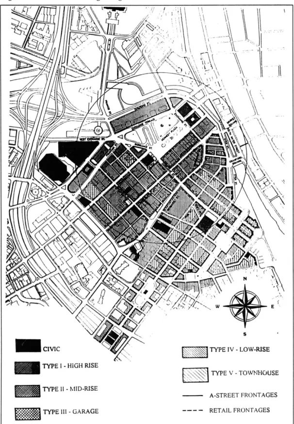
The outcome of this process was the Mercer Island Town Center Plan. This report contained four components: 1) an illustrative plan (Figure 2) and an accompanying set of design codes, which were intended to show how the area could be built over time; 2) a series of "demonstration projects," which were feasible designs based on the illustrative plan and its codes; 3) a market and economic analysis; and 4) recommendations for the "next steps." These recommendations included creating a private "custodian" of the vision in the form of a nonprofit corporation, establishing a public/private fundraising partnership, setting up a visible headquarters, and conducting community outreach to "sell" the TND vision to Mercer Island's residents and business people.
During the next year, the planning staff developed a set of development and design guidelines for the CBD based on the Town Center Plan. These guidelines were explicitly intended to "implement the policies of the Comprehensive plan and design concepts outlined in the Town Center Plan."3 8 After a series of public
meetings, open houses, and hearings, the Town Center District Development and Design Requirements was approved by the City Council in December 1995. As the regulatory mechanism for implementation of the TND plan, the document included not only building, street, parking lot, and auxiliary design requirements, but also administrative procedures for design review and conditional use permitting. Currently, the City Council is considering ways to create a "custodian" of the vision, as well as how to partner with a private developer interested in building in the CBD.
Figure 2: Mercer Island Illustrative TND Plan
PROVIDENCE, RHODE ISLAND
Downtown Providence did not develop until more than a century after the town's colonization in the late seventeenth century. Shipping and manufacturing activities catalyzed downtown development in the early 1800's, and downtown Providence prospered until the mid 1940's. The city reached its
peak population of 253,504 in 1940. However, the suburbanization process after World War II depleted the central city of much of its industrial, commercial and retail activities. By 1980 the population had bottomed out at 156,804 people, a loss attributed to the growth in suburban areas surrounding Providence.39 This decline inevitably affected downtown Providence by draining both businesses and consumers from the central city.
To address these problems, a Zoning Commission was formed in the early 1980's. The Commission conducted a study that concluded that the downtown was "changing" and that the dense commercial C3 zoning, which allowed few other activities in the CBD, was a liability. The Commission created a D1 zoning district which allowed for more diverse uses in the downtown. At the same time, the Providence Foundation, a downtown business organization, initiated the Capital Center project which ultimately redeveloped 60 acres of land consisting of former Amtrak switching tracks on the downtown's edge.
Yet these efforts were only a partial solution to downtown's derelict condition. The Providence 2000 Plan identified insufficient parking, the lack of activity in the downtown retail core, and the lack of alternate modes of transportation as a few of "Downcity's" continuing problems. The psychological effect of the decline of the 1980's was a loss of "confidence in Downcity's economic, cultural and civic value to Providence and to Rhode Island at large."40
The eminent opening of a new convention center downtown was one of the main catalysts for looking afresh at the area. As the 1994 Downcity Providence Plan stated, the Convention Center would not succeed "unless downtown is alive, inviting, and full of things to see and do," and that "new investment in downtown [was] particularly needed in the current economic climate, and an
39 City Plan Commission, Providence 2000: The Comprehensive Plan, p. 24.
4 Downcity Task Force and the Department of Planning and Development, Downcity Providence: An Implementation Plan, p. 1.
increased tax base in downtown [would] benefit city programs throughout Providence's neighborhoods."41
The City's interests in economic revitalization and a renewed confidence in downtown Providence were matched by the business community. In fact, it was the Providence Foundation, led by businessman Arnold Chace, who initially asked Andres Duany to conduct a design charrette for the downtown area.42
When approached by the Foundation about the idea, the Mayor responded enthusiastically and promised partial financial support for the event.
Duany and his design, marketing, and economic consulting team came to Providence in 1992. The Planning and Development Department organized the event, offering meeting space in the downtown Fleet Center, bringing together members of the City Plan Commission, and providing names of potential interviewees. The consultants led the 5-day charrette.
The end product, Downcity Providence: Master Plan for a Special Time, included a regulating plan (Figure 3) and proposed "small, affordable, achievable increments by both the private and public sectors" as the best means to realize the plan. It recommended a "one-stop permitting process" as well as a series of "special projects" that could "make a great difference and reverse the negative attitude many people have about the downtown."43
The energy created through the charrette process motivated the City to appoint a Downcity Task Force to recommend code and management improvements and to stimulate investment in the old retail core. The Task Force, in turn, established eleven different subcommittees. After 16 months of work, the group
41 Ibid., p. 1.
42 Interview with Samuel Shamoon, April 1, 1996.
43 Andres Duany and Elizabeth Plater-Zyberk, Downcity Providence: Master Planfor a Special
produced a document called Downcity Providence: An Implementation Plan. Within this document were several recommendations, including:
1. Creation of the Downcity Commission -- to facilitate and monitor the implementation plan and to act as the downtown neighborhood advocate;
2. Establishment of a fund to carry out the public physical improvements recommended in the plan;
3. Adoption of the Downcity Plan as part of the city's Comprehensive Plan;
4. Immediate actions which could be accomplished quickly, to help support the long-term implementation of the plan.44
The City followed the third recommendation, adopting the Downcity TND plan as part of the Comprehensive Plan. In addition, the City Council approved the Downcity Overlay District on October 24, 1991. Including land use, architecture, and design standards for the downtown, the explicit purpose of the overlay district was "to encourage and direct development in the downtown to ensure that: new development is compatible with the existing historic building fabric... development encourages day and night time activities that relate to the pedestrian.. .the goals of the Comprehensive plan are achieved."45
44 Downcity Task Force et. al., Downcity Providence: An Implementation Plan, p. 6.
To date, the second recommendation of the Downcity Task Force, a "fund to carry out the physical improvements," has not been established. However, the City has tapped a few sources to pay for some physical improvements in Downcity. The Redevelopment Agency, for example, funded the construction of a vest-pocket park at the corner of Westminster and Mathewson Streets and is currently building a number of liner buildings around it. The Planning and Development Department has also used ISTEA funds to improve the lighting, sidewalks, and trees along Mathewson Street, and UDAG money to finance a downtown lighting program.
SAN JOSE, CALIFORNIA
Jackson-Taylor is an ethnically diverse neighborhood one mile north of downtown San Jose. With approximately 4600 residents, the Jackson-Taylor neighborhood was historically an industrial area with strong ties to the food industry. Over the years, the community suffered disinvestment due to rapid urbanization and the relocation of the region's orchards and farms to the San Joaquin and Central Valleys. When the last industrial employer, Glorietta Foods, closed down in 1985, a "vacuum" was created.46 Concerns about filling that void with new land uses, and the prospect of light rail service from San Francisco coming through the neighborhood, prompted the City to target Jackson-Taylor for revitalization in its San Jose 2000 Plan.
The 1987 Jackson-Taylor Revitalization Plan laid the groundwork for the neotraditional planning effort which began in 1992. The earlier revitalization plan included recommendations for converting the industrial neighborhood into a primarily residential area with supporting commercial uses. The Planning Department engaged Calthorpe Associates and appointed a Citizen Task Force to prepare a long-term neotraditional plan for the neighborhood. Chaired by the Planning Commissioner, the 16-member Task Force included neighborhood association representatives, Jackson-Taylor residents, business people, and
housing specialists. A technical advisory committee comprised of city staff from other departments was assembled to assist in the planning effort.
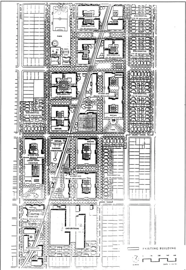
The working group met monthly for nine months. The Planning Department set the agenda for these meetings and provided materials. After a short hiatus during the preparation of the state-mandated Environmental Impact Report, the Planning Department held public meetings to discuss the plan. After incorporating the community concerns raised during the public meetings, the end product was a document called the Jackson-Taylor Residential Strategy. It included an illustrative plan (Figure 4) and a set of design and policy recommendations for guiding future development in the neighborhood. The recommended actions for implementing the neotraditional plan included:
1. A City-initiated General Plan amendment to create the Jackson-Taylor Planned Residential Community.
2. City Council-initiated rezonings, consistent with the amended General Plan designations within the study area, should be processed as and when such rezonings might preserve or improve the potential for development consistent with the strategy. Rezonings should incorporate the design guidelines set forth in the strategy.
3. The city should come to a decision on the phasing and funding for proposed parks as soon as possible.47
The City Council approved the Jackson-Taylor Residential Strategy plan as an independent document and its major provisions were incorporated into the General Plan in 1992. The San Jose 2020 General Plan designated the Jackson-Taylor neighborhood as a Planned Residential Community (PRC), a designation which is generally intended to provide the private development sector with "a greater degree of flexibility in developing innovative projects while also incorporating special development and design objectives."48
47
bid., p.47.
Figure 4: Jackson-Taylor Illustrative TND Plan
- j
RS'IDSNT9AL M01314d USB8 .L d -. r ( REAIENEET
__._as - Cs+ /N 1 11:111D,5s T T o ... 1.,ld'.m...4i--- ~~ ----INDUSTRIAL C-RE DENTIAL Ct DMCME29E160 NTIAL MIE usA 12-4...,.. In---1fom .1-PARK. A ESTA c JWAM -- A XISTING BUILDING DATk I 4.
Source: City of San Jose. Jackson-Taylor Residential Strategy, p. 21.
BIDENTIAL
BI NIAL
As of April 1996, one property has been rezoned for mixed use in accordance with the PRC provisions since its adoption. The City has not invested in any substantial public improvements in the Jackson-Taylor neighborhood, although the Redevelopment Agency is attempting to garner redevelopment money to help develop the property that has been rezoned.49
SUISUN CITY, CALIFORNIA
Suisun City, population 26,000, is 44 miles northeast of San Francisco. Connected to San Francisco Bay by the Suisun Channel, the city flourished during the Gold Rush as a port. It remained a hub of agricultural Solano County through World War II, but when Interstate 80 opened in 1963, commercial development along the interstate corridor began to drain the downtown of its businesses.
By the early 1980's, most of the storefronts along Main Street were empty and the warehouses along the waterfront abandoned. Downtown felt the effects of the "overcrowded and crime-ridden" Crescent neighborhood nearby and the "ugly" oil-storage tanks at the head of the channel's estuary that polluted the harbor.50 The City also had fiscal concerns. During the 1980's the city had relied
on residential development fees to meet its budget and fund capital improvements, but it was rapidly approaching buildout and could not rely on the fees much longer.
49 Interview with Laurel Prevetti, April 3, 1996.
Figure 5: Suisun City Illustrative TND Plan -:~7 -151M In - -8 13 11
1. Existing neighbor'hoods 6. Whispering Bay 10. Old town
2. Town Plaza 7. Wetlands 11. Crescent Grammar School
3. Civic Center 8. New residential 12. Crystal Elementary School
4. Yacht Club neighborhoods 13. Suisun Channel
5. Pierce Island 9. Intermnodai station
With these concerns in mind, the City began to consider redevelopment of the Old Town area. In 1983, the City adopted the Downtown Specific Plan for the Historic Downtown and Waterfront sections in an effort to revitalize the area. Seven years later, although the construction of a new City Hall had been completed and the designation of a Redevelopment Project Area had been made, most of the recommendations of the 1983 Specific Plan had not been implemented.
A last place ranking in a 1988 San Francisco Chronicle survey of the quality of life in 98 bay area cities catalyzed community interest in revitalization.1 The City decided it needed to make "comprehensive revisions" to the 1983 Specific Plan, "particularly in the areas of land uses, public facilities, and circulation."5 2 At this
point the neotraditional planning process began. The Suisun City Redevelopment Agency hired the ROMA Design Group and Halcyon Limited in July 1990 to prepare a Concept Plan and Development Guidelines for specific Downtown project sites. The Redevelopment Agency appointed an eleven member Community Advisory Committee, which worked with the design consultants over a 13 month period to revise the initial concept plan (see Figure 5). The 16-person staff of the Redevelopment Agency was extensively involved in the plan development; general public input occurred throughout the process.53
The regulatory mechanism for implementing the neotraditional plan and its codes was the adoption of the design and policy recommendations as Amendments to the 1983 Downtown Specific Plan and then the adoption of the Amended Downtown Specific Plan as an amendment to the Suisun City General Plan. These provisions essentially established the Downtown and Waterfront area as an overlay district whose purpose was to "implement the General Plan
5 Arnold Berke, "Turnaround Town," Historic Preservation, p. 71.
52 City of Suisun City, Suisun City Amended Downtown Specific Plan, p. 1.
through land use designation on a map, listing or referencing permitted specific uses, standards for development and appropriate special conditions."54
The Redevelopment Agency acted as the master developer for several of the specific projects within the TND project area, bringing in developers to handle individual projects. The O'Brien group, for example, was the housing developer for the Victorian Harbor neighborhood. As of May 1995, several substantial projects had been completed. They include: demolition of the Crescent neighborhood and construction of the Victorian Harbor neighborhood, demolition of warehouses, dredging and widening of the Suisun Channel, construction of a Town Plaza, creation of a waterfront promenade, restoration of the historic Lawler House, construction of landscaped parking lots, and the installation of new water pipes and storm sewers to serve Main Street.55
SUMMARY
The descriptions just given provide a general overview of the TND planning experiences of the case studies. To be sure, these descriptions have simplified the complex political, economic, and social issues that contributed to, and influenced, each community's experience. At the same time, however, the benefit of this bird's-eye view is that a number of observations and comparisons between their processes can be easily made. These observations will be addressed in the analysis contained in Chapter 3.
5 City of Suisun City, Amended Downtown Specific Plan.
CHAPTER
3:
ANALYSIS
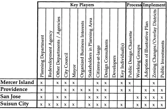
Chapter 2 established a basic story line of the planning processes in each of the four case study communities. As was generally evident from those descriptions, the players, planning activities, and implementation strategies each city utilized were similar in a number of ways. It was equally evident that they approached the planning process differently in some respects. This chapter examines specific elements of their experiences in greater detail. The comparative analysis is organized into three major areas of inquiry: the key players and their roles, the planning and design activities, and implementation tools.
The key players and their roles. To date, developers and neotraditional planning consultants have played central roles in the planning of isolated neotraditional communities. The integration of TND principles into urbanized areas, however, requires additional players because the playing field, so to speak, is so much more complex. As the descriptions of the case studies' experiences in Chapter 2 showed, identifying the myriad needs and concerns of a community and garnering the resources to satisfy those needs in a TND plan required considerable involvement of the local government, design consultants, citizens, stakeholders, developers, and regional agencies.
Arguably, much of the challenge in establishing an effective planning process is involving these players at the appropriate time, and in appropriate roles. As a precursor to the examination of the cases' actual planning processes, this portion of the analysis will consider who was involved in the case studies' TND planning efforts and what roles they were playing. The roles to be addressed include Initiator, Organizer, Contributor, Technical Advisor, Designer, Motivator, Decision Maker, and Promoter.56
56 Martha Lampkin discusses a different classification of roles in relation to the "city building
network:" schemer, promoter, coordinator, regulator, packager, designer, and builder. See Lampkin, Intervention in the City Building Network: An Evaluation of the AIA's R/UDAT Program, Master's Thesis, Massachusetts Institute of Technology, 1981, p. 13.