HAL Id: hal-02390908
https://hal.archives-ouvertes.fr/hal-02390908
Submitted on 3 Dec 2019
HAL is a multi-disciplinary open access
archive for the deposit and dissemination of
sci-entific research documents, whether they are
pub-lished or not. The documents may come from
teaching and research institutions in France or
abroad, or from public or private research centers.
L’archive ouverte pluridisciplinaire HAL, est
destinée au dépôt et à la diffusion de documents
scientifiques de niveau recherche, publiés ou non,
émanant des établissements d’enseignement et de
recherche français ou étrangers, des laboratoires
publics ou privés.
Coastal surfaces managed for salt production and
conservation issues for abandoned sites
Rutger de Wit, Alice Vincent, Ludovic Foulc, Mario Klesczewski, Olivier
Scher, Claudine Loste, Marc Thibault, Brigitte Poulin, Lisa Ernoul, Olivier
Boutron
To cite this version:
Rutger de Wit, Alice Vincent, Ludovic Foulc, Mario Klesczewski, Olivier Scher, et al..
Seventy-year chronology of Salinas in southern France:
Coastal surfaces managed for salt production
and conservation issues for abandoned sites.
Journal for Nature Conservation, Elsevier, 2019,
Contents lists available atScienceDirect
Journal for Nature Conservation
journal homepage:www.elsevier.com/locate/jnc
Seventy-year chronology of Salinas in southern France: Coastal surfaces
managed for salt production and conservation issues for abandoned sites
Rutger De Wit
a,⁎, Alice Vincent
a, Ludovic Foulc
b, Mario Klesczewski
b, Olivier Scher
b,
Claudine Loste
c, Marc Thibault
d, Brigitte Poulin
d, Lisa Ernoul
d, Olivier Boutron
daMARBEC, Université de Montpellier, CNRS, Ifremer, IRD, 34095 Montpellier, France
bConservatoire d'espaces naturels du Languedoc-Roussillon, 34000 Montpellier, France
cConservatoire du Littoral, Délégation de rivages Languedoc-Roussillon, 34000 Montpellier, France
dTour du Valat Research Institute, Le Sambuc, 13200 Arles, France
A R T I C L E I N F O Keywords:
Corine land cover 4.2.2 Microbial mats Waterfowl Halophytes Coastal lagoon Delta A B S T R A C T
After World War II, twenty-nine coastal Salinas (122 km2), located in the vicinity of coastal lagoons and in deltas,
were exploited along the Mediterranean coastlines in South France. Today, only five of these are still actively producing salt, currently representing 175 km2. Concomitant with the abandonment of many of the smaller
Salinas, the larger Salinas in the Rhône delta (Camargue) strongly increased their surfaces at the expense of natural ecosystems, of which a part has also been abandoned after 2009. This paper documents these changes in landscape use by chronological GIS mapping and describes the fate of the 91 km2of abandoned Salina surfaces.
The majority of this area (88 km2) is included in the Natura 2000 network, among which most (74 km2) has been
acquired by the French coastal protection agency (Conservatoire du Littoral) to be designated as Protected Areas. Only a very minor part (< 1%) has been lost for industry and harbour development. Managing abandoned Salinas as Protected Areas is a challenge, because of the different landscape, biodiversity conservation, natural and cultural heritages issues at stake. In two cases, abandoned Salinas have been brought back again into ex-ploitation by private initiative thus allowing for the protection of original hypersaline biodiversity. In other cases, the shaping of the landscape by natural processes has been privileged. This has facilitated the spontaneous recreation of temporal Mediterranean wetlands with unique aquatic vegetation, and offered opportunities for managed coastal re-alignment and the restoration of hydrobiological exchanges between land and sea. In other areas, former salt ponds continue to be filled artificially by pumping favouring opportunities for waterfowl. This has often been combined with the creation of artificial islets to provide nesting ground for bird colonies pro-tected from terrestrial predators.
1. Introduction
The Mediterranean climate in southern France, and particularly the hot dry summer periods and windy conditions, are favourable to salt extraction from sea water in Salinas, which are man-built structures also referred to as solar salt works or salterns. For example, in the
Camargue area (Rhône delta) the evaporation is about 1500 mm.year−1
which largely exceeds a precipitation of about 600 mm year-1(Boutron
et al., 2015). Salt extraction activities are mainly concentrated during late summer when the evaporation levels are the highest. Salinas have been documented in southern France since Antiquity, although the most important creations occurred during the 19th and the 20th centuries,
which can be considered as the boom period for solar extraction of salt in the French Mediterranean region.
The creation of Salinas has exerted a profound impact on the phy-siognomy of the coastal landscape while claiming large surfaces from the original pristine ecosystems. Crystallizer ponds are man-made fea-tures, rectangular in shape, where the salt is precipitated as highly enriched NaCl. These crystallizer ponds are fed with concentrated seawater at a salinity of about 290. Therefore, the seawater needs to circulate in a series of pre-concentrating ponds, thereby reducing its
volume to one tenth by evaporation and losing the minerals CaCO3
(calcium carbonate) and CaSO4(gypsum), by successive precipitation.
Hence, the sea water changes its chemistry during the trajectory in the
https://doi.org/10.1016/j.jnc.2019.03.003
Received 21 December 2018; Received in revised form 14 February 2019; Accepted 19 March 2019
⁎Corresponding author at: Centre for Marine Biodiversity, Exploitation and Conservation (MARBEC), (Université de Montpellier, CNRS, IRD, Ifremer), bâtiment 24,
Place Eugène Bataillon, Université de Montpellier, F-34095 Montpellier Cedex 5, France. E-mail address:rutger.de-wit@umontpellier.fr(R. De Wit).
1617-1381/ © 2019 The Authors. Published by Elsevier GmbH. This is an open access article under the CC BY-NC-ND license (http://creativecommons.org/licenses/BY-NC-ND/4.0/).
preconcentration ponds (Usiglio, 1849), which allows to obtain a highly purified halite (NaCl) in the crystallizer ponds. The NaCl thus obtained
contains traces of MgSO4, MgCl2 and CaSO4. A strong brine rich in
potassium (K+) and bromide (Br−) is also obtained in the crystallizer
ponds, which is often discarded (De Wit & Grimalt, 1992;Oren, 2009).
The pre-concentration ponds are surrounded by dikes and inter-connected with sluices. Hence, in addition to the surfaces occupied by the crystallizer ponds, large areas of natural ecosystems including salt marshes, Mediterranean wetlands and some coastal lagoons have been converted into pre-concentration ponds for the creation of the Salinas. The first pre-concentration ponds are often very irregularly shaped while more regular patterns can be found at higher salinities. Most of the Salinas along the Mediterranean coast are located above mean sea level and the mean tidal amplitude in the North-western Mediterranean (≈20 cm) is insufficient to fill these ponds. Hence, pumping stations have been used to pump seawater into the first pre-concentration ponds (e.g. Salins de Giraud and Salin Saint Lucie), while the water transport along well managed trajectories from pond to pond is either entirely gravity driven or involves a combination of pumping and gravitational water movements. In other cases, pre-concentration ponds were created within coastal lagoons (e.g. Salin des Pesquiers) that were directly filled from the sea by gravity and pumping was used to fill the crystallizer ponds located above mean sea level.
Although the irregular shape of many pre-concentration ponds suggests a high degree of naturalness, modifications of the landscape and active water management imply important changes in ecological conditions with respect to the initial state. Pre-concentration ponds are actively maintained submerged during the summer and based on the specific requirements of the company can be either dry or maintained submerged during winter. In contrast, the natural Mediterranean wet-lands tend to have an opposite seasonal pattern by filling from rain and run-off during the autumn and drying out during the summer seasons (Sadoul, Walmsley, & Charpentier, 1998). The creation of Salinas has increased the surfaces and water volumes with hypersaline conditions along the coast, resulting in the destruction of coastal habitats, dis-turbance of marine fish migration and filtering of the local biodiversity
towards salinity tolerant animal and plant communities (Britton &
Johnson, 1987;Tour du Valat, 2012). Salinas constructed next to the sea and requiring coastline defence also generate severe artificialness of the coastline characterized by the loss of beach ecosystems. Never-theless, the highly saline ponds also contribute to maintain very ori-ginal and specialized, although species-poor planktonic and benthic communities. The planktonic communities include the brine shrimp Artemia spp., the red-orange coloured Chlorophyte Dunaliella salina, and communities of red-coloured extremely Halophilic prokaryotes, in-cluding Archaea and the bacterium Salinibacter ruber. The changes of the planktonic prokaryotic communities along the salinity gradient in Spanish Mediterranean Salinas have been described using molecular
approaches (Benlloch et al., 2002;Ventosa, De la Haba, Sánchez-Porro,
& Papke, 2015). The Artemia spp. represent a rich, albeit rather sea-sonal, source of food for birds, particularly Greater Flamingos (Phoe-nicopterus ruber Linnaeus, 1758); the pink-reddish coloration of these birds is based on trophic transfer of the beta-carotene of Dunaliella salina and other microalgae via Artemia that is finally converted to
as-taxanthin (Fox, 1955). In general, Salinas represent a very important
environment for sedentary and migrating bird species. The first pre-concentration ponds are visited by many bird species, while at higher salinities mainly Greater Flamingo, Common Shelduck (Tadorna ta-dorna Linnaeus, 1758) and a range of small Charadriiforms (Charadrius spp., Calidris spp., Larus spp.) occur frequently. The Salina may also provide some small islands surrounded by hypersaline water surfaces that are used as breeding grounds by several colonial species (e.g. terns, gulls, avocets, stilts), protected from terrestrial predators such as foxes (Sadoul et al., 1998). The benthic communities along the salinity gra-dient are characterized by conspicuous microbial mats, including cya-nobacteria Coleofasciculus chthonoplastes with Chloroflexus-like bacteria
at salinities of 50–110 and Halothece/Phormidium and purple sulfur
bacteria at salinities of 120–290 (Caumette, Matheron, Raymond, &
Relexans, 1994; De Wit & Grimalt, 1992; Oren, 2009; Villanueva, Grimalt, De Wit, Keely, & Maxwell, 1994). In addition, invertebrates are quite abundant in the benthos and epi-benthos of pre-concentration
ponds, but species richness decreases strongly with salinity (Britton &
Johnson, 1987). Finally, most Salinas have been separated from their continental watersheds by a freshwater or oligohaline circumferential canal. The role of this canal is to intercept any freshwater input from small tributaries and runoff that would dilute the hypersaline water in the pre-concentration ponds and crystallizers. The construction of these canals has inevitably destroyed the shallow but rich ecoclines and ecotones at the freshwater seawater interface by creating abrupt
boundaries (De Wit, 2011).
The development of Salinas over the last two centuries has altered the physiognomy of the landscape. Existing habitats and ecotones were destroyed where the Salinas were created, thereby locally causing a decrease in diversity of plant, birds and invertebrate species. However, Salinas provide habitats for natural communities, which are adapted to higher salinities and play a pivotal role in maintaining local populations of flamingos, seabirds and shorebirds. Hence, adding Salinas along the coast can result in increasing the biodiversity of the coastal landscapes when large areas of natural ecosystems remain that have not been ad-versely degraded by human intervention. On the other hand, Salinas have also been abandoned, particularly since the 1960’s. During a period of intense mechanisation, many of the smaller Salinas were closed. During the first decade of the 21st century only three Salinas were producing salt in the South of France, among which two extracted the salt from seawater. Moreover, the main company, the Salins du Midi or Groupe Salins, was threatening to close its major facility in Salin de Giraud and de-localise the salt production to countries with lower wages. Particularly based on these events, it has been invoked that globalisation of the economy may interfere with nature conservation issues, jeopardizing in this case the breeding success and survival of the
Greater Flamingos (Béchet et al., 2012). The Salinas have also had an
important impact on the local socio-cultural landscape. Their creation in southern France has stimulated the local economy and ensured
steady employment (Roché & Aubry, 2009). This has been particularly
important in the Camargue where the socio-ecological system, domi-nated by extensive pastoralism and agriculture, had only provided a
low number of jobs (Picon, 1988). In addition to the economic values,
the local population also attributes important socio-cultural values linked to the visual aesthetics, recreation, hunting, and biodiversity
within and at the periphery of the Salinas (Ernoul et al., 2018).
The abandonment of Salinas in coastal areas thus represents a major challenge for nature conservation, including major aspects of landscape physiognomy, biodiversity conservation and the natural and cultural heritage. The general aim of the present study is to document the dy-namics of changes in the lagoonal and deltaic environments in southern France over the last seven decades and to discuss their implications from the conservation perspective. We firstly document the chronology of the spatial coverage of Salinas over the last seventy years by pre-senting the historical context and chronologically mapping the surfaces of the Salinas since World War II. Secondly, we describe the fate of the abandoned Salinas, their novel spatial uses, and the management op-tions for the conservation of biodiversity that have been considered in some cases and are currently attempted in different locations.
2. Historical context
Salt extraction ponds have been documented in southern France since Antiquity. During the Middle Ages, small Salinas were owned by noblemen, the clergy and some private owners from the third estate,
including independent farmers and Jews (Dupont, 1958). Many were
located along the shorelines of the coastal lagoons in
plain in the Rhône delta (Hérault, 2010;Leenhardt, 1939) and close to
the industrial areas in Marseille (Daumalin, 2003). During the ancient
regime, salt extraction and commerce were strongly controlled and heavily taxed by the Royal power, with a notorious tax named “Ga-belle”. For example, the creation of Salinas on the lido of the Etang de Thau was authorized by Louis XVI just before the French Revolution (Boudet, 1998). The Gabelle was abolished during the French Revolu-tion and this has been considered by some authors as a strong incentive for creating new Salinas. Nevertheless, the tax on salt was actually
re-introduced by Napoleon in 1806 (Leenhardt, 1939; Sands & Higby,
1949), albeit in a way that was much more favourable to private
in-itiatives. This tax was finally abandoned in 1946. This resulted in the creation of three novel Salinas early in the 19th century in the Aude
department (Leenhardt, 1939) and close to Berre lagoon, but not in the
Camargue where an increase of salt production was not very profitable
due to low prices (Picon, 1988). The demographic and economic
de-velopments and particularly the growing demands for industrial salt were the most important incentives for the creation of novel Salinas since the mid 19th and the 20th century. This period can be considered as the boom period for solar extraction of salt in the French Medi-terranean area. The salt extraction was also rationalized and moder-nized during the 19th century by adopting a continuous flow process with frequent salinity monitoring, which allowed for the production of purer NaCl. New scientific knowledge about the chemical composition
of seawater and precipitation processes during evaporation (Usiglio,
1849), along with the use of a densimeter, expressing salinities in
de-grees Baumé, or “aéromètre” in French, further improved the quality of the production. As a result of these technological developments, salt extraction activity changed from traditional/artisanal production into an industrial enterprise based on the concept that technological
pro-gress would allow humans to dominate nature (Hérault, 2010).
Major actors during the studied period were the company the Salins du Midi and since 1975 the Conservatoire du Littoral. The commercial company the Salins du Midi was founded in 1856 when it owned al-ready 40,000 ha of surface including Salinas, coastal wetlands and dunes in southern France among which 11,000 ha in Aigues-Mortes (Hérault, 2010). The Salina in Aigues-Mortes was the major Salina from the beginning of this period and is still the company’s masterpiece. During the rest of the 19th and the 20th century, the company acquired many of the Salinas and surrounding wetlands from smaller companies and thus became the predominant salt producer in southern France. Progressively, the Salins du Midi was transformed into a multinational industry, the Groupe Salins, which nowadays owns solar salt extraction works in France, Spain, Tunisia and Senegal with a total production of 4
million tons of salt annually (Groupe Salins, 2019). The Conservatoire
du Littoral (French coastal protection agency) is a public body linked to the Ministry in charge of the environment created by law in 1975. The Conservatoire du Littoral has a clear mission to acquire land along the coastlines, the littoral zones of lakes and wetlands, in order to guar-antee their conservation as protected areas. In 2018, this encompassed 700 sites in France and its overseas territories representing 200,605 ha. The governance is based on a council made up of a diversity of stake-holders, which is further supported by a scientific advisory board (Conservatoire du Littoral, 2019). After acquisition, in most cases, the council takes a decision to declare the surfaces as “Public domain of the Conservatoire du Littoral”, meaning that these properties are im-prescriptible and inalienable, i.e. meaning that neither the designation as a protected area nor the property rights cannot be changed in the future. In compliance with the law of 1975, the Conservatoire du Lit-toral does not perform the practical management of the sites itself, but rather establishes partnerships with local organisations that actually manage the sites. Together with these local partners, the Conservatoire du Littoral develops the master plans for the management that need approval by its council to become effective and be implemented by these local partners.
3. Study site and methods
3.1. Site
The study site comprised the littoral zone of the Mediterranean Sea
in southern France (seeFig. 1) including the Gulf of Lion, the Côte
d’Azur and the Thyrrhenean Sea in Corsica. Salinas are located i) di-rectly on the coastline, ii) bordering the littoral zone of coastal lagoons or iii) in deltaic settings (e.g. the Camargue).
3.2. Chronological cartography of Salinas
As a first approach, we used Corine land-cover (CLC) from 2012, and extracted CLC-class 4.2.2 Salinas, which were defined as salt-pans, active or in the process of abandonment. While this was a good starting point to create a first version of the data base, this layer presented the following two problems. First, it did not differentiate between Salinas with active salt extraction and abandoned Salinas, which was a major objective of this study. Second, the areas of actively exploited Salinas were clearly underestimated as many of the pre-concentration ponds were neglected and generally identified either as 4.2.1 salt marshes or 5.2.1 coastal lagoons. This is due to the limitations of the visual in-terpretation of satellite images used for CLC, where crystallization ponds and rectangular pre-concentration ponds were clearly
distin-guishable by their parcellation and embankment systems (Bossard,
Feranec, & Otahel, 2000), in contrast to the irregularly-shaped pre-concentration ponds that were often confounded with natural systems. A series of digitalised topographic maps from 1950 at a 1:25,000 scale, i.e., “Scan 25 historique” was obtained from the National
Geographic Institute (IGN) web portal (Géoportail, 2019a) and used to
screen for existing Salinas shortly after World War II. These Salinas were itemized including their pre-concentration ponds based on his-torical information. They were included in the database with their geographic names and polygons were created manually for these items, and compared with the CLC 2012 -class 4.2.2. Eight Salinas observed in 1950 were not represented by the CLC 2012 -class 4.2.2., corresponding to six abandoned Salinas and two Salinas merged in a larger neigh-bouring Salina. One item bordering Etang Pissevache was listed on the CLC 2012 -class 4.2.2 (N° 10), but not present on the 1950 ordnance survey map. Ground truthing showed that this very small item was incorrectly identified as a Salina as it was used for wastewater treat-ment in open ponds. Therefore, it has been excluded from our data base. In addition, Salin d’Estarac and Salin de Pérols (CLC 2012 -class 4.2.2., N° 26 and N° 3, respectively) were excluded from the data base
because these were closed before 1940 (Leenhardt, 1939).
For the years 1975, 2000, 2006, 2012, and 2018, topographical maps and aerial photographs were obtained the IGN web portals (Géoportail; Géoportail, section “remonter le temps”). Literature data and knowledge of the localisation of pumping stations and functioning of exploited Salinas obtained from expert interviews were used to re-itemise the functional pre-concentration ponds not included in CLC-class 4.2.2, as belonging to the Salinas. Polygons were created manually for these items and constituted an added class 4.2.2.A to distinguish these added surfaces from those recognised by Corine land-cover as 4.2.1 or 5.2.1. For 2012 and 2018, both the CLC-class 4.2.2 and the added class 4.2.2.A are represented. Merged polygons were also created for 2012 and 2018 to depict the entire surfaces of the Salinas. For the years 1975, 2000, and 2006, both classes were systematically merged into a single shapefile for each Salina and the polygons obtained were checked against topographic maps and aerial photographs to verify if these represented the real coverage of the Salina and corrected if needed.
Literature data (Balzano, 1993; Boudet, 1998, 2013; Boudou,
Andreu-Bousset, & Dautis, 2013; Gourret, 1897; Leenhardt, 1939; Maughan, 2015) and expert information were used to determine the dates when Salinas were created and when the salt extraction was
abandoned between 1950 and 2018, either permanently or temporarily. For the latter, new start-up dates were also reported. Likewise, we used
literature data (Sadoul et al., 1998;Tamisier, 1990) and interpretation
of aerial photographs (IGN portal “remonter le temps”) to describe the extension of the exploited surfaces for the existing Salinas.
Web portalsConservatoire du Littoral, 2019; Cerema, The French
national observatory of the sea and the littoral, 2019), were used to-gether with aerial photography (Géoportail, section “remonter le
temps”,2019b)and used for defining the current spatial planning and
conservation designations of abandoned Salinas.
All cartography was prepared with Q-GIS, Quantum GIS, Las Palmas version 2.18.19. Open Street map were used as a plug-in used in Q-GIS, https://umap.openstreetmap.fr/fr/.
4. Results
4.1. Cartography and statistics of surfaces
We identified that shortly after World War II, 28 different coastal Salinas were actively exploited for salt extraction in continental France
and 1 on the Island of Corsica (seeTable 1andFig. 1). These Salinas
used salt from Mediterranean seawater with the exception of the Salin de l’Etang de Berre which has used salt brine from a salt mine as a source. Sizes ranged from 17 ha (Salin de Ferrand and Salin de Jai) to 3941 ha (Salin d’Aigues Mortes).
This represented a total of 12,225 ha (122.3 km2) in 1950. In 2018,
only 5 Salinas are still operational in continental southern France and
none in Corsica, representing a surface area of 17,517 ha (175.2 km2).
No new Salinas were created since 1950.
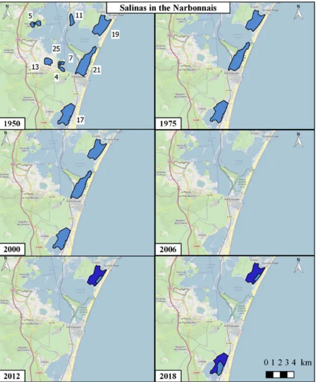
Figs. 2 and 3represent two series of maps depicting the extension of surfaces that were exploited for salt extraction in 1950, 1975, 2000, 2006, 2012 and 2018 for the Salinas in the Narbonnais and the Salin de Giraud in south-eastern Camargue, respectively. Maps of the other areas are included in the on-line supplementary material together with *.kml files corresponding to the ensembles of the exploited Salinas in these 6 years
(“Salinas_Mediterranean_France_xxxx.kml”, with xxxx as the year).
The area in the Narbonnais (Fig. 2) is illustrative of what happened to
the small (< 100 ha) and medium-sized (around 300 ha) Salinas in southern France: all the small Salinas in the Narbonnais that were still operational shortly after WWII, were abandoned between 1962 (Salin de Grimaud and Salin de Tallavignes) and 1968 (Grand Salin de Si-gean). The three medium-sized Salinas were closed around 2005 by the multinational salt company Groupe Salins (formerly Les Salins du Midi). Nevertheless, two of these, i.e. Salin Ile San Martin (Gruissan) and Salin de la Palme were brought back into exploitation in 2012 and 2013, respectively. These areas are located on public land, which is owned by the State and administered as “Domaine Public Maritime” (DPM) and by the municipality, are currently exploited by a newly created private company called the Salins de l’Aude. Thus, a local pri-vate initiative was the driver for re-launching salt production.
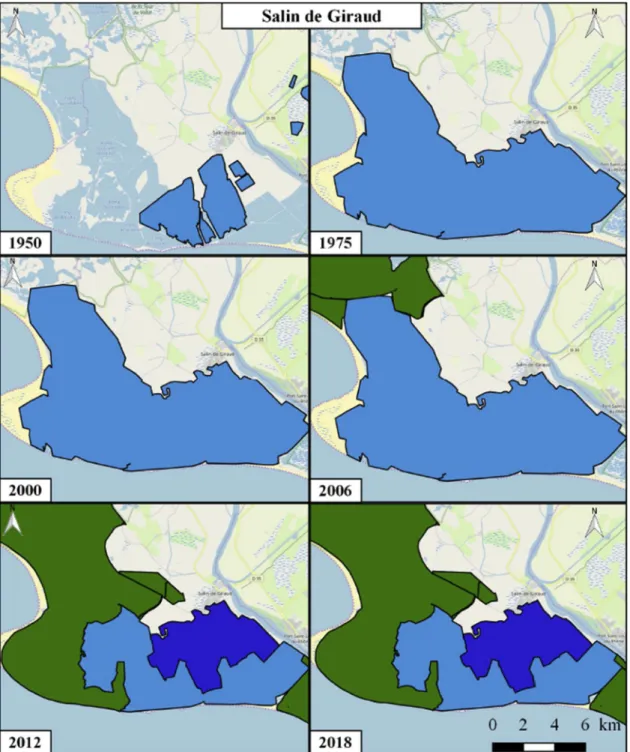
In contrast, the Salin de Giraud increased its size fourfold between 1950 and 1975 (from 2630 ha to 12,154 ha), which included the in-corporation of the smaller Salinas Mas du Crottes and Esquineau. Its Fig. 1. Salinas exploited along the Mediterranean coast in continental southern France and Corsica shortly after World War II according to the IGN topographic map (Geoportail, scan historique) of 1950 (cf. Table 1 for the names of the Salinas and supplementary material for the shapefile, “Salinas_Mediterranean_-France_1950.kml”).
Table 1 List of Salinas along the Mediterranean Sea in continental southern France and Corsica, listed from the SW (Spanish border Gulf of Lions) to the East (Côte d’Azur) and Corsica (Tyrrhenean Sea). See map in Fig. 1 for localisation using the unique reference number for each Salina. The numbers up to 27 have been attributed following Corine Land Cover (4.2.2 of 2012), while higher numbers (in italics) were attributed by the authors and correspond to Salinas not listed by CLC that were still exploited in 1950. Number 1) Name of the salina salt extraction current status creation date closure date re-opening date Owner spatial planning designation exploited surface 1950 (ha) exploited surface 2018 (ha) Narbonnais (Gulf of Lion) 17 SALIN DE LA PALME ACTIVITY 1884 2005 2013 DPM Salt extraction 412 412 4 SALIN DE TALLAVIGNES CLOSED 1803 1962 CONSERVATOIRE PA-CdL / N2000 -2) 37 13 GRAND SALIN DE SIGEAN CLOSED 1300 1968 CONSERVATOIRE PA-CdL / N2000 96 25 SALIN DE FERRAND CLOSED 1800 1962 CONSERVATOIRE PA-CdL / N2000 17 7 SALIN DE GRIMAUD CLOSED 1795 1962 CONSERVATOIRE PA-CdL / N2000 19 21 SALIN SAINT-LUCIE CLOSED 1831 3) 2005 CONSERVATOIRE PA-CdL / Regional NR/ N2000 -70 ha for Harbour 441 5 SALIN DE PEYRAC CLOSED 1300 1967 CONSERVATOIRE PA-CdL / N2000 80 11 SALIN DE CAMPIGNOL CLOSED 1880 1963 DPM Natura 2000 75 19 SALIN D'ILE SAINT MARTIN ACTIVITY 1910 2006 2012 DPM, Municipality of Gruissan Salt extraction 392 392 Coastal lagoons of Thau and Palavas (Gulf of Lion) 9 SALIN DE BAGNAS CLOSED 1789 1975 CONSERVATOIRE PA-CdL / National NR /N2000 285 14 SALIN DE CASTELLAS CLOSED 1779 1967 CONSERVATOIRE PA-CdL / N2000 173 15 SALIN DE VILLEROY CLOSED 1779 1968 CONSERVATOIRE PA-CdL / N2000 186 16 SALIN DE FRONTIGNAN CLOSED 1338 1968 CONSERVATOIRE PA-CdL / N2000 218 12 SALIN DE VILLENEUVE CLOSED 1100 1969 CONSERVATOIRE PA-CdL / N2000 100 Camargue and Berre Lagoon 24 SALIN AIGUES MORTES ACTIVITY 13th century 4) – SALINS Salt extraction 3940 9092 27 SALIN DE GIRAUD ACTIVITY, but reduced since 2009 1856 – CONSERVATOIRE, SALINS Salt extraction (5000 ha as PA-CdL /N2000) 2891 7195 35 SALIN DU MAS DES CROTTES incorporated into 27 unknown 1951 incorporated into 27 SALINS 69 33 SALINS DE ESQUINEAU incorporated into 27 unknown 1951 incorporated into 27 SALINS 75 29 SALIN DU CABAN CLOSED 1882 1970 Port of Marseille Fos N2000 567 30 SALIN DU RELAI CLOSED unknown 1970 Port of Marseille Fos N2000 485 32 SALIN DE GARROUYAS CLOSED 1882 1950 5) Port of Marseille Fos Industry -Harbour 137 28 SALINS FOS SUR MER / la marronède CLOSED 1833-1836 1985 Municipality of Fos sur mer N2000 205 31 SALIN DE RASSUEN CLOSED 1808 1953 Municipality of Istres N2000-ENS 6) 36 22 SALIN DE BERRE ACTIVITY 1100 – SALINS Salt extraction 7) 428 428 37 SALIN DE JAI CLOSED 1923 1955 Communauté des communes ENS 6) 17 8 SALIN DU LION CLOSED (822)-1802 1955 Communauté des communes ENS 6) 61 Hyères (Côte d'Azur) 20 SALIN DES PESQUIERS CLOSED 1848 1995 CONSERVATOIRE PA-CdL / N2000 424 18 VIEUX SALINS DE HYERES CLOSED 1200 1995 8) CONSERVATOIRE PA-CdL / N2000 331 Corsica 2 SALIN DE PORTO VECCHIO CLOSED 1795 2001 shortlisted for PA 29 1) Numbers up to 27 attributed by Corine Land Cover, others attributed by the authors. 2) PA-CdL = Protected Area, public domain of the Conservatoire du Littoral, integrated in Natura 2000. 3) Salin de Saint-Lucie was strongly enlarged in surface between 1928 and 1937. 4) Formerly called Salin du Peccais. 5) Salt extraction was interrupted in Salin de Garrouyas from 1936 to 1940, and completely abandoned in 1950. 6) ENS = “Espace Naturel Sensible” a designation based on the Urbanistic code and implemented locally by Departments. 7) Salin de Berre uses brine from in inland salt-mine close to Manosque as the primary material for extracting the salt. 8) Salt extraction was interrupted in Vieux Salins d’Hyères from 1970 to 1980, and completely abandoned in 1995 (in 1980 the production was only 1500 tonnes to achieve a maximum of 17,000 tonnes in 1989).
productivity peaked at 1 million tons of salt per year in the 1980′s From the 1990’s Groupe Salins faced the loss of several clients from the chemical industry, resulting in the reduction of salt production (now ca. 300,000 tons per year). As a result, from 2008 onwards, a large part of the Salinas and surrounding areas (dunes and marshes) were sold to the Conservatoire du Littoral. This resulted in a reduction of the Salina surface area by approximately 5000 ha.
Fig. 4 depicts the time course of the number of Salinas and the surfaces used for salt extraction along the Mediterranean coast in southern France between 1950 and 2018. The period of 1960–1970 is characterized by the abandonment of 12 Salinas, mostly smaller ones, concomitantly with a strong increase of their total surface area. This
corresponds to a period of mechanisation and rationalisation of the productivity. Thus, between 1950 and 1975, 2480 ha of Salina were abandoned while over 14,336 ha were taken into exploitation mainly
by the conversion of natural areas in the Camargue delta (cfFigs. 3 and
4) and smaller extensions elsewhere, resulting in a net increase of
11,856 ha.
Between 1975 and 1995 the situation remained stable. At the turn of the century, a second period of abandonment started and by the end of 2006, only 3 Salinas were still exploited, the two Salinas in the Camargue and the Salin de l’étang de Berre. Local private initiatives succeeded in re-opening two Salinas in the Narbonnais region (see above). As a result, in 2018 five Salinas, with a total surface of Fig. 2. Chronological maps depicting the Salinas (blue) in the Narbonnais region (Mediterranean coastline close to Narbonne, southern France, cf.Fig. 1). Refer to the 1950 map for the names of the Salinas. The dark blue corresponds to the surfaces identified by the Corine Land Cover 2012, layer 4.2.2 which underestimates the surface due to neglecting many of the pre-concentrating ponds (see Methods). Name of Salinas (1950 map): 4, Salin de Tallavignes; 5, Salin de Peyrac; 7, Salin de Grimaud; 11, Salin de Campignol; 13, Grand Salin de Sigean; 17, Salin de la Palme; 19, Salin d’Ile Saint Martin; 21, Salin de Saint-Lucie.
17,517 ha were exploited for salt extraction, among which four used Mediterranean seawater as the resource.
Fig. 5gives the land use and spatial planning designations for the areas in the Narbonnais, where salt production has occurred at any time between 1950–2018. Maps for the other areas are provided in the supplementary material. This shows that the two medium-size Salinas have been re-opened since 2012. All of the smaller Salinas with the exception of the Salin de Campignol have been acquired by the Con-servatoire du Littoral and integrated into the Natura 2000 network. Salin de Campignol is owned by the state (DPM, i.e. maritime state-administered property), but it was also integrated in the Natura 2000 network. For the Salin de Sainte-Lucie, a small part in the SE has been
converted into industrial area for the harbour of Port-la-Nouvelle, while the rest was acquired by the Conservatoire du Littoral, integrated in Natura 2000 and designated as a Regional Nature Reserve. The entire area is included in a Natural Regional Park (IUCN-type 5 designation), i.e. the PNR la Narbonnaise en Méditerranée.
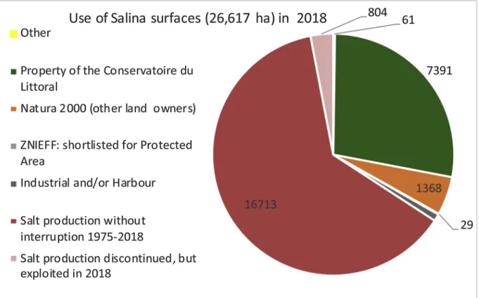
The total surface where salt extraction occurred any time between 1950 and 2018 is 26,617 ha. In 2018, 66% of this surface is still being
exploited in 5 Salinas (Fig. 6). A minor part (252 ha, < 1%) has been
converted into industrial or harbour areas. The rest of the abandoned Salinas sites were designated as a Protected Areas acquired by the Conservatoire du Littoral (28%), the site in Corsica has been short-listed for denomination as a Protected Area and 1368 ha (5%) is included in Fig. 3. Chronological maps depicting the Salin de Giraud region (S.E. part of the Camargue, Mediterranean coastline, southern France, cf.Fig. 1). The dark blue corresponds to the surfaces identified by the Corine Land Cover 2012, layer 4.2.2 which underestimates the surface due to neglecting many of the pre-concentrating ponds (see Methods). Note that the smaller Salinas Mas de Crottes and Esquineau have been integrated in Salin de Giraud since 1951. Acquisitions by the Con-servatoire du Littoral are marked in dark green.
Natura 2000, but has now another land owner. Hence, nature con-servation is the predominant vocation of sites previously used for salt production.
4.2. Conservation issues and possible uses for abandoned Salinas Given the important cultural heritage associated with coastal Salinas, nature conservation and environmental protection manage-ment bodies must consider not only the biodiversity of these unique landscapes, but also take into account the socio-cultural and economic
values associated with them (Ernoul et al., 2018). Hence, in S. France,
four primary options have been proposed for the abandoned Salinas: 1 To conserve their infrastructure (pumping stations, dikes and ponds)
and re-start salt production activities.
2 To conserve their infrastructure (pumping stations, dikes and ponds) as it was, or use a simplified infrastructure in order to maintain water in ponds throughout the year, albeit without producing salt. The simplifications may imply to abandon a certain number of dikes in order to create larger-sized ponds. In addition, it is no longer necessary to pre-concentrate the water for salt precipitation in the crystallizers. Therefore, the fine-tuned management of water flows along successive pre-concentration ponds is often abandoned. As a result, the very stable salinity gradients across ponds are no longer maintained and salinities within ponds may be subject to large fluctuations.
3 Abandon the maintenance of the infrastructure, allowing for the erosion and breaching of the dikes. Re-establish the natural pro-cesses, including reconnection with surrounding wetlands, the de-velopment of dunes and temporal Mediterranean coastal wetlands. 4 A mixed solution, whereby water is actively managed to maintain submerged conditions on a part of the surface based on using a simplified infrastructure, while the re-establishment of natural processes is favoured elsewhere.
The first option, i.e. re-opening for salt production has been im-plemented successfully for two Salinas in the Narbonnais region, i.e.,
the Salins d’Ile Saint Martin and Salins de la Palme, in 2012 and 2013, respectively. The salt production in these Salinas was managed by a newly created local company “the Salins de l’Aude” which developed a diversified economic model based on producing salt for human con-sumption including high quality salt (“fleur de sel”), lower quality in-dustrial salt for snow removal in the region, and the development of ecotourism activities combined with some additional shellfish farming activities.
The advantages of this option are that it allows for the conservation of the specific biodiversity associated with the Salinas, particularly birds and halophilic microorganisms. This includes the conservation of communities along the artificially maintained but rather stable salinity gradients from seawater up to halite saturation. It also presents an at-tractive option for the local populations and the tourists because it combines the protection of the cultural heritage with water-filled ponds landscape during the summer season and provides, at the same time, educational and cultural benefits. This option has facilitated some local economic activities; however, due to the absence of tides in the Mediterranean, maintaining or restoring the pumping stations and the electricity network to feed them is costly. Furthermore, maintaining infrastructures against sea surges may require continuous and high investment especially along coastlines affected by coastal erosion. In addition, long-term sea level rise induced by climate change might further jeopardize salt production activity in the most exposed sites in the future by totally erasing the current geomorphology and water circulation in these areas. Another difficulty with this option is that a non-competitive clause (known as non-salendi clause) has systematically been included by the Groupe Salins in its sales agreements, preventing the new owner of the Salinas to produce salt in order to reduce com-mercial competition. Most of the abandoned Salinas were indeed owned by the Salins du Midi (former name of Groupe Salins), while in the Narbonnais, however, the surface of the Salinas de la Palme and Ile Saint Martin are maritime state-administered property of the French state (DPM) and a part is owned by townships (e.g., Gruissan). In the latter cases, the salt extractions were based on concessions, i.e., the company Groupe Salins was allowed by the government to use these land surfaces for salt-production. However, in 2005 and 2006, this company abandoned the salt production in Salinas de la Palme and Ile Saint Martin, respectively, without renouncing their concessions. Actually, the Groupe Salins sub-rented its concessions to a local com-pany with the condition of prohibiting salt production. The practice of sub-renting a concession was questioned and brought to Court by the township of Gruissan. In 2013, the Cour de Cassation terminated the concession to Groupe Salins by considering that it is illegal for the company to sub-rent the DPM maritime state-administered property (Cour de cassation, 2013), thereby creating a jurisprudence. Hence, re-starting of the salt extraction in the Narbonnais was freed-up after this juridical battle and the company Salins de l’Aude was granted a new concession to use the surface for salt production.
The second option has been implemented in the case of the Salinas in Hyères and has been considered as an option for the Salin de Saint-Lucie, although it was finally not retained. In the Salinas of Hyères, the pre-concentration ponds are filled by gravity from the sea and pumping is used both to feed the crystallizer ponds and evacuate excess water to the sea. Hence, an electricity network is needed to fuel the pumping stations. As the objective is no longer to produce salt, it is not necessary to maintain the full salinity gradient. The maximum salinity can be limited to 150, allowing for the divergence of the highly saline water to the sea. Moreover, the trajectory of the water can be simplified and does not need to be so fine-tuned as is the case for Salinas in production. Hence, it is not necessary to repair all the dikes as larger ponds can be created. Nevertheless, the costs of maintenance and management (i.e. water pumping) associated to this management can still be very high taking into account that no income is generated from salt production. The main advantage of this option is the conservation of specific parts of biodiversity, i.e. waterbirds and halophilic microorganisms. Another Fig. 4. Time course of the total number of exploited Salinas (black line, left
scale) and surfaces used in hectares (closed circles, right scale) for salt extrac-tion along the Mediterranean coast in southern France between 1950 and 2018.
advantage is its aesthetic value linked to water-filled ponds (Ernoul et al., 2018). In addition, the heritage values can be enhanced to in-clude more strongly the cultural aspects with the conservation of the industrial vestiges (existing hydraulic infrastructure, offices, deposits, workers houses). Finally, this management can be combined with creative projects such as the building of islets within the ponds to fa-vour breeding bird colonies or developing a mosaic of ponds with dif-ferent depths favouring difdif-ferent bird species.
The third option has been attempted in the territory in Salin de Giraud (SE Camargue), which was acquired by the Conservatoire du
Littoral in 2009 (cf.Fig. 3) and in most of the smaller Salinas that have
been abandoned in the 1960′s. This implied stopping the pumping of water permanently, and abandoning the maintenance of dikes. Without pumping, water flow and salinity dynamics are the result of the balance between freshwater and seawater inflows, rain, evaporation, and
wind-driven forces (Boutron et al., 2015).Fig. 7shows the salinity variations
from March to September, for the years 2016–2018, in a series of ponds acquired by the Conservatoire du Littoral in Salin de Giraud, 7 years after abandoning the exploitation for salt extraction. All ponds showed large variations of salinities that were often very different from the salinity targets set during the previous salt production period, showing both salinities above and below these targets for ponds 2, 8, and for
pond 5, respectively (cf.Fig. 7). Largest variations were observed in
2016. Periods of higher salinities corresponded to lower water heights and drying out of the shallower parts in the ponds that appeared as playas.
In addition, after stopping the artificial flooding during the summer period, most pre-concentration ponds located on the upper parts of the former Salinas initially appeared as dry surfaces devoid of vegetation, and the surface became colonised progressively by halophilic vegeta-tion (e.g., Salicornia spp. and Limonium spp.). These areas represent a specific interest for breeding birds during spring and summer (i.e. Fig. 5. Current land use and spatial planning designation in 2018 of the Salinas in the Narbonnais region. Note that the majority of the small Salinas have been acquired by the Conservatoire du Littoral and are integrated in the Natura 2000 network. Salin de Campignol has another owner (French state, i.e. maritime state-administered property, DPM), but is also integrated in Natura 2000. For the Salin de Sainte-Lucie, a small part in the SE has been converted into industrial area of the harbour of Port-la-Nouvelle, while the rest was acquired by the Conservatoire du Littoral, in-tegrated in Natura 2000 and designated as a Regional Nature Reserve. The Salins de la Palme and Ile Saint Martin were exploited as Salinas for salt production in 2018. Name of Salinas: 4, Salin de Tallavignes; 5, Salin de Peyrac; 7, Salin de Grimaud; 11, Salin de Campignol; 13, Grand Salin de Sigean; 17, Salin de la Palme; 19, Salin d’Ile Saint Martin; 21, Salin de Saint-Lucie.
Kentish Plover Charadrius alexandrinus, Spectacled Warbler Sylvia con-spicillata, Tawny Pipit Anthus campestris, Western Yellow Wagtail Motacilla flava). As a result, migrant waterbirds diversity (i.e. dabbling ducks and Charadriiforms) is more important in submerged natural saltmarshes and Salicornia scrubs than in active saltworks. Hence, in the abandoned parts of Salin-de-Giraud, migratory birds responded posi-tively to the re-establishment of natural functioning with its diversity of
newly created habitats. Furthermore, coastal processes such as the formation of small dunes and tidal creeks have been favoured.
The situation is less dynamic in the more sheltered sites such as those of the smaller sized former Salinas, located on the interior shore of coastal lagoons. These Salinas, although many abandoned in the 1960’s, still show extensive remnants of dikes that delimit different pond systems. In most cases these have turned into Mediterranean type Fig. 6. Current land use and spatial planning designation in 2018 of the area along the Mediterranean coastline in France, where salt extraction has occurred at any time between 1950–2018.
Fig. 7. Salinity variations, from March to September, in several locations of the different ponds in the part of Salin de Giraud acquired by the Conservatoire du Littoral in 2009 (7–9 years after abandoning the exploitation for salt extraction). The box and whisker plots (total range and 50% quartile) describe the salinity variations during the water-filled period, and the red square the corresponding average salinities from March to September, for the years 2016, 2017, and 2018. The green lines indicate the targeted salinities for these ponds for the periods March to September set by the Groupe Salins before 2009 (no data on the variation of salinities have been communicated but are assumed to be low). Salinity data courtesy of Emilie Luna-Laurent (Tour du Valat Research institute), and Patrick Rigaud (Natural Regional Park of Camargue).
temporary coastal wetlands, being filled with water after the autumn rains and drying out during the summer season, eventually favouring rare and highly threatened communities associated with ephemeral coastal lagoons. These communities comprise charophyte species (Lambert, Desmots, Le Bail, Mouronval, & Felzines, 2013;Mouronval et al., 2015) and other endemic Mediterranean flora (French natural heritage inventory INPN, 2018; several reports listed in supplementary on-line material). The temporal Mediterranean lagoons and the ponds in the smaller abandoned Salinas, have been studied intensively by
botanists during the last decade (Collectif, 2007; Klesczewski, 2012;
Lepareur, Bertrand, Papuga, & Richeux, 2013). The angiosperm Al-thenia filiformis Petit (Potamogetonacea) and the Characeae Lam-prothamnium papulosum Groves and Tolypella salina Corillon represent a particular interest for conservation. The latter charophyte, which is extremely rare and has only been discovered in 2009 in the Medi-terranean region, now benefits from a national protection status. In these smaller abandoned Salinas creative management has also been used, particularly the creation of islands within ponds for colonial bird nesting. As a result, a positive impact was observed for charadriiforms (i.e. terns and gulls) the populations of which increased strongly fol-lowing these management actions. In contrast to Salin de Giraud, mi-gratory waterfowl diversity was not enhanced in most of the abandoned smaller Salinas as freshwater habitats in the surroundings were still preferred by these birds. The Estagnol reserve represented such fresh-water habitats for the Salinas in Villeneuve and Frontignan.
The medium and larger-sized Salinas on the seafront built in coastal plains directly adjacent to the sea suffer more strongly from erosion after abandonment than the above-mentioned smaller Salinas on the interior shore of coastal lagoons. Hence in the abandoned parts of Salin
de Giraud acquired by the Conservatoire (seeFig. 3), sea surges lead to
breaches in the sea-front dike and inner dikes because they were not built to resist sea-level rise and increased wave force and increased water levels in the lagoons. Such a process favours a more rapid return to the original natural conditions occurring before the implementation or extension of the Salinas. Another advantage is that this management offers new opportunities for managed coastal re-alignment. This is a major issue in the Camargue delta, where most of the abandoned saltpans are now being turned into a buffer zone to adapt to sea level rise induced by climate change.
Where the former saltpans have been reconnected to surrounding watersheds, natural developments might lead to the creation or the ecological restoration of brackish or even freshwater ecosystems, re-sulting in increased species richness and more diversified landscapes. Moreover, it might enable the restoration of marine fish and other aquatic fauna migration between the sea and freshwater environments via the lagoonal type of environments. A major issue is how to change the hydraulic regime from pumped water and controlled flows along ponds into more naturally gravity-driven exchanges that are the less hampered by artificial structures. However, this appears difficult to achieve fully for the sites in Salin de Giraud of the Conservatoire, be-cause the Groupe Salins did not sell all the key areas that are essential for an optimal water management by gravity. Thus, the currently exploited Salina still represents an obstacle for exchanges of the la-goonal environments and the salt marshes with the sea and the fresh-water fresh-watersheds in the hinterland. Hydrodynamic modelling is an interesting tool to understand these complex dynamics and to solve these kind of problems by defining the best strategy to change the hy-draulic regime while balancing the various issues at stake in these areas.
In addition, the managerial implementation of the third option is often not well understood by the local populations who might reject the “desert”-like dried-out surfaces during summertime and regret the loss of the cultural industrial heritage. Despite the advantages to the bio-diversity and wetland functioning, this management scheme must in-volve a strong awareness raising aspect for the local communities as they can be resistant to landscape changes and the impacts that this
could have on their socio-cultural activities (Ernoul & Wardell-Johnson,
2016). Another issue at stake is that managers want to maintain control
over the water circulation in some parts of these areas, particularly
related with the conditions for emblematic species (Ernoul et al., 2018).
For example, the Greater Flamingo in the Salin de Giraud has used an artificial islet in the Fangassier lagoon in order to breed successfully. Despite the fact that the Fangassier lagoon is no longer used as a pre-concentration pond in the salt extraction process, managers aim at continuing the protection of the breeding flamingo colony from ter-restrial predators. Therefore, the islet needs to be surrounded with a water level sufficient to prevent access by these terrestrial predators. Hence, a lack of dike maintenance could thus lead to possible breaches and associated losses of water resulting in breeding failure. Dikes are also maintained in some areas to manage extreme climatic situations (e.g. sea submersion, flash floods from rivers). This is the case for the protection by the sea dike in the center of the former Salina in Salin de Giraud. This sea dike is managed by the French state, which has a legal obligation to maintain the structure to ensure the protection of property and the safety of persons located further inland.
The fourth option has been advised for the Regional Nature Reserve of Salin de Saint-Lucie by a joint advice of the scientific advisory boards of the Regional Natural Park and the Conservatoire du Littoral of 12 September 2013. It has been characterized as “scenario C; towards natural salt marsh vegetation in the North and Salinas in the South (vers des paysages de sansouires au nord and salins au sud)”. In the North part of former Salinas, infrastructures will not be repaired (sea-front dike, inner dykes, water pumping station) while the natural wetlands of the beach, dunes and former Salinas will be reconnected. The creation of new opportunities for halophilic vegetation is particularly important in the Narbonnais region where this halophilic vegetation comprises
many endemic species (Klesczewski, 2013). This sector can be seen as a
testing ground for migration and adaptation of vegetation and animals during the next decades facing sea level rise. In the South, existing infrastructures will be simplified, including re-building where neces-sary, to restore around 100 ha of the Salinas environments. The aim is not to produce salt but rather to provide better nesting conditions for Mediterranean coastal birds (construction of islets). The main target is to enhance the network of breeding sites along the Mediterranean coast in southern France, for the long-term protection of colonial charadrii-forms. This scenario would restore temporary Mediterranean coastal wetlands and salt marshes, in conjunction with the conservation of the cultural and industrial heritage and its associated specific biodiversity. This scenario was also chosen because the local population appreciates the water-filled ponds in the landscape during summer. Therefore, it was difficult to re-naturalize the entire site of this Salina.
5. Discussion
The solar salt works or Salinas are an important heritage in Mediterranean France both for their socio-cultural aspects and their ecological assets (particularly for birds, halophilic animals and micro-organisms). The cultural heritage is related to an industrial tradition for
salt extraction and production since the 19thcentury. Moreover, the
presence of the Salinas has prevented massive urbanisation of the coastline. On the other hand, the mechanisation with the enlargement of approximately 17,000 ha of the larger Salinas since 1950 has resulted in the destruction of natural salt-marshes and coastal plains. Despite the fact that the shape many of the pre-concentration ponds much look like that of natural ponds, their creation and use in the Salinas has caused important changes in ecological structures and functioning.
Salinas are reported by the EU initiative Corine Landcover (class or layer 4.2.2, Salines) and 21 of the 29 Salinas identified in this study were indeed present in the Corine land cover data base. For these 21 Salinas identified by the CLC 4.2.2 layer only 5 were still in use in 2018 and 16 completely abandoned. The CLC 4.2.2 layer gives a surface of approximately 10,000 ha of Salinas, which is a strong underestimation
both compared to 26,761 ha used at any time as Salinas between 1950 and 2018, as well as with respect to the 17,517 ha currently in use. This clearly illustrates the major problems of the CLC 4.2.2 layer, i.e., it does not differentiate between active and abandoned Salinas and neglects many of the pre-concentration ponds (see Methods). Therefore, we warn against uncritical use of CLC 4.2.2 layer in GIS-based studies. To determine the real surface area used as Salinas during different periods, we combined Corine landcover with literature review (recent history), knowledge of the functioning of Salinas, mobilisation of expert knowledge and GIS work based on topographic maps and aerial pho-tographs.
Since 1950, the number of coastal Salinas exploited for salt ex-traction along the Mediterranean coastline in France has decreased dramatically, first from 29 in 1950 to only 3 in 2006; then after, there was a slight increase to 5 active Salinas. Despite, this strong reduction, the exploited surface area is actually 43% higher than in 1950. This pattern is in agreement with a general homogenization of the landscape since 1960, losing mosaic patterns and natural areas. The loss of many small-scale salt extractions is regrettable from the cultural point of view, and people in the coastal regions nowadays have to travel on average larger distances to visit an active Salina. Exploited Salinas have been completely abandoned in Corsica and on the Côte d’Azur and were absent in the Narbonnais region from 2006–2012. While, the biodi-versity in the Salinas is lower than in the natural coastal systems upon which these were built, a mosaic landscape both comprising the natural coastal systems and Salinas may have a higher biodiversity than the original natural landscape because the Salinas contribute an original biodiversity, particularly for water birds, halophilic animals and micro-organisms. The mosaic of wetland habitats provides nesting opportu-nities for colonial bird species and complementary foraging habitats. Thus, the re-opening of salt production in Salinas, as in Salin de Saint Martin and La Palme can be welcomed from the biodiversity and cul-tural heritage points of view. These medium-sized Salinas have shown that by diversifying the business model, such exploitations can be economically profitable and comply with the tenets of sustainable de-velopment. Given the obvious advantages both for the environment and the socio-economic conditions, it is regrettable that the non-salendi clause has been systematically included in sales contracts for the abandoned Salinas. This clause jeopardizes the re-opening of salt ex-traction and requires increased public funding for the management of the abandoned sites that cannot count on income generated from salt production.
Thirty-four percent of the 26,761 ha along the French Mediterranean coastline, used for salt production at any time between 1950 and today, have been abandoned by the salt extraction compa-nies. Only a minor part (< 1%) was converted into industrial areas or harbour facilities. Nevertheless, several of the smaller Salinas close to Marseille were converted into industrial areas between WWI and WWII, as for example the Salinas that disappeared after the creation of the
Caronte canal close to Port de Bouc and Martigues (Bertran de Balanda,
2014). The vast majority of the abandoned sites (9244 ha) was set apart
for nature conservation purposes, and most of this surface has been acquired by the Conservatoire du Littoral (7391 ha). These properties are imprescriptible and inalienable as the “Public domain of the Con-servatoire du Littoral” and by law of 1975 should be managed as pro-tected areas. This paper described the different management options that have been envisaged and are currently being implemented.
Abandoned Salinas offer unique opportunities for the ecological restoration of natural systems including Mediterranean wetlands, salt marshes and naturally-functioning coastal lagoons in addition to man-agement opportunities for coastal re-alignment. This is clearly an ob-jective for the abandoned Salinas located at Salin de Giraud and partly in Salin de Saint-Lucie. Hence, allowing breaching of dikes can facilitate a return to more natural conditions with in fine the restoration of hy-drobiological exchanges between the land and the sea. The latter is the main objective together with creating opportunities for managed
coastal re-alignment. However, this type of management often implies some accompanying measures of ecological restoration to achieve the full potential.
The smaller inland Salinas are often located in more sheltered areas and not prone to strong erosion of dikes that remain as remnants in the landscape for decades. These systems have been used preferentially for re-creating temporal Mediterranean coastal wetlands with interesting aquatic flora including the association of the angiosperm Althenia fili-formis the charophyte Lamprothamnium papulosum. While ephemeral Mediterranean wetlands have been rather neglected by botanists in the past, it has now been realized that these environments represent very interesting associations of species and that the ponds in abandoned Salinas represent good surrogates for restoring these interesting en-vironments. Former Salinas can also provide a regulation service as protection against marine submersion propagating from lagoons by stocking the volumes from sea surges and flash floods. Natural re-connection with surrounding wetlands is also to be considered in inland Salinas in order to restore their functionality.
Altogether, the situation for the Salinas in southern France appears now in 2018 much more positive than during the crisis around 2007. Nowadays, 5 coastal Salinas are active and appear to have good per-spectives for the next years. In addition, the vast majority of the abandoned sites have been acquired by the Conservatoire du Littoral and are managed as protected areas.
However, Salinas may be strongly impacted by climate change and particularly by sea level rise during the 21st century.
Funding
This study received funding from the European Union’s Horizon 2020 research and innovation programme under grant agreement n° 641762 (Ecopotential).
Acknowledgements
Rutger De Wit thanks Samuel Robert and Marie-Laure Apers-Trémélo for introducing him in GIS cartography. Special thanks are due to Mr. Patrice Gabanou (Director Salins de l’Aude), Mr. Alain Gauthier (Corsica), Mr. Marc Del Corso (Metropole of Aix-Marseille-Provence), Ms. Maud Blasco (Ville de Martigues), Céline Felices (Ville de Port de Bouc) for sharing with us their expert knowledge on the history of the salt production in S. France. Emilie Luna-Laurent and Patrick Rigaud provided the salinity measurement data for the ponds in the Camargue and Emmanuelle Romet and Murielle Ribot are thanked for facilitating a deliberative approach for determining the future of the abandoned Saint-Lucie Salinas.
Appendix A. Supplementary data
Supplementary material related to this article can be found, in the
online version, at doi:https://doi.org/10.1016/j.jnc.2019.03.003.
References
Balzano, R. (1993). Rassuen ou la mémoire du sel des étangsMarseille: Imprimerie A. Robert (Second part).
Béchet, A., Rendon-Martos, M., Rendon, M. A., Amat, J. A., Johnson, A. R., & Gauthier-Clerc, M. (2012). Global economy interacts with climate change to jeopardize species conservation: The case of the greater flamingo in the Mediterranean and West Africa.
Environmental Conservation, 39, 1–3.
Benlloch, S., Lopez-Lopez, A., Casamayor, E. O., Ovreas, L., Goddard, V., Daae, F. L., et al. (2002). Prokaryotic genetic diversity throughout the salinity gradient of a coastal solar saltern. Environmental Microbiology, 4, 349–360.
Bertran de Balanda, S. (2014). Paysage industriel et imaginaire à Martigues. Rives
méditerranéennes, 4, 31–41.https://doi.org/10.4000/rives.4578http://journals.
openedition.org/rives/4578.
Bossard, M., Feranec, J., & Otahel, J. (2000). Technical report No 38. The revised and supplemented Corine land cover nomenclatureCopenhagen: Copenhagen: European Environment Agency.
Boudet, G. (1998). Les salins de Sète ou l’esprit d’entreprise au XVIIIe siècle. Études
Héraultaises 1997–1998. n° 28–2911.http://www.etudesheraultaises.fr/wp-content/
uploads/1997-1998-16-les-salins-de-sete-ou-l-esprit-d-entreprise-au-xviiie-siecle.pdf.
Boudet, G. (2013). Les salins du Garrouyas. In J. Blondel, G. Barruol, & R. Vianet (Eds.).
L’encyclopedie de la Camargue (pp. 129). Paris: Libella.
Boudou, N., Andreu-Bousset, V., & Dautis, F. (2013). Les salins entre terre et mer. Les carnets
du Parc N° 13. Narbonne: Parc Naturel Régional de la Narbonnaise en Méditerranée.
Boutron, O., Bertrand, O., Fiandrino, A., Höhener, P., Sandoz, A., Chérain, Y., et al. (2015). An Unstructuredunstructured numerical model to study wind-driven circu-lation patterns in a managed coastal mediterranean wetland: The vaccarès lagoon system. Water, 7, 5986–6016.https://doi.org/10.3390/w7115986.
Britton, R. H., & Johnson, A. R. (1987). An ecological account of a Mediterranean Salina: the Salin de Giraud, Camargue (S. France). Biological Conservation, 42, 185–230. Caumette, P., Matheron, R., Raymond, N., & Relexans, J.-C. (1994). Microbial mats in the
hypersaline ponds of Mediterranean salterns (Salins-de-Giraud, France). FEMS
Microbiology Ecology, 13, 273–286.https://doi.org/10.1111/j.1574-6941.1994.
tb00074.x.
Cerema (2019). The French national observatory of the sea and the littoral. (Accessed 19 December 2018)http://cerema.maps.arcgis.com/apps/MapSeries/index.html? appid=354ccc3737fe4df78ed82e184713ee0c.
Collectif (2007). Catalogue régional des mesures de gestion des habitats et des espèces d’intérêt
communautaire – type lagunes littorals. DIREN L-R, Biotope, CEN L-R, Tour du Valat,
Pôle relais lagunes méditerranéennes274. http://www.occitanie.developpement-durable.gouv.fr/IMG/pdf/2007-09-18_Referentiel_gestion_lagunes_DIREN_LR5_ cle5ef197.pdf.
Conservatoire du Littoral.http://www.conservatoire-du-littoral.fr/, 2019, (Accessed 25 July 2018).
Cour de cassation (2013). Chambre civile 3, 2 juillet 2013. 12-15.579 . (Accessed 19 December 2018)https://www.legifrance.gouv.fr/affichJuriJudi.do?idTexte= JURITEXT000027673611.
Daumalin, X. (2003). Du sel au pétrole. L’industrie chimique de Marseille-Berre au XIXe siècle. Marseille: Editions Paul Tacussel.
De Wit, R. (2011). Biodiversity of coastal lagoon ecosystems and their vulnerability to global change. In O. Grillo (Ed.). Ecosystems biodiversityRijeka: InTech Open Access Publisher. (Chapter 2) https://www.intechopen.com/books/ecosystems- biodiversity/biodiversity-of-coastal-lagoon-ecosystems-and-their-vulnerability-to-global-change.
De Wit, R., & Grimalt, J. O. (1992). Microbial ecosystems in Spanish coastal salinas; An ecological and geochemical study of biomarkers. Limnetica, 8, 205–212.http://www. limnetica.net/documentos/limnetica/limnetica-8-1-p-205.pdf.
Dupont, A. (1958). L’exploitation du sel sur les étangs de Languedoc (IXe-XIIIe siècle).
Annales du Midi: revue archéologique, historique et philologique de la France méridionale,
70(41), 7–25.https://doi.org/10.3406/anami.1958.6196.
Ernoul, L., & Wardell-Johnson, A. (2016). Representing the Greater Flamingo in Southern France: A semantic analysis of newspaper articles showing change over time. Ocean &
Coastal Management, 133, 105–113.https://doi.org/10.1016/j.ocecoaman.2016.09.
015.
Ernoul, L., Wardell-Johnson, A., Willm, L., Béchet, A., Boutron, O., Mathevet, R., et al. (2018). Participatory mapping: Exploring landscape values associated with an iconic species. Applied Geography, 95, 71–78.https://doi.org/10.1016/j.apgeog.2018.04. 013.
Fox, D. L. (1955). Astaxanthin in the American Flamingo. Nature, 175, 942–943.https:// doi.org/10.1038/175942a0.
French natural heritage inventory, INPN (2018). III.1.1.f. - Association à Althenia filiformis
et Lamprothamnium papulosum. (Accessed 20 December 2018)https://inpn.mnhn.fr/
habitat/cd_hab/3763/tab/description?lg=en.
Géoportail (2019a). The portail of topographic maps of the National Geographic Institute in
France (IGN). (Accessed: 25 July 2018)https://www.geoportail.gouv.fr/.
Géoportail (2019b). section “remonter le temps”. (Accessed 25 July 2018)http://
remonterletemps.ign.fr/.
Gourret, P. (1897). Les étangs du Midi de la France et leurs pêcheries. Annales du Musée d’histoire naturelle de Marseille. Zoologie 1897, Tome V, Memoire N°1.
Groupe Salinshttp://www.salins.com/salins-group-2/introduction-and-implantations/? lang=en(Accessed 25 July 2018).
Hérault, L. (2010). La construction du salin moderne; La transformation des salins du Midi de
la France XVIIIe-XIXe siècles. Aix-en-Provence: Presses universitaires de Provence.
Klesczewski, M. (2012). Suivi mésologique de la flore aquatique. CEN L-R & EE. Montpellier: CEN L-R, Écologistes de l’Euzière, Communauté d’Agglomération Bassin de Thau74. (2012). Suivis scientifiques sur les espaces naturels de Thau Agglomération. Année 2012. – Communauté d’Agglomération du Bassin de Thau. – Rapporthttp://www. cenlr.org/divers/refs/Klesczewski_2012_Suivis_herbiers.pdf.
Klesczewski, M. (2013). Réserve naturelle régionale de Sainte-Lucie - Hiérarchisation des
enjeux de biodiversité sur les anciens salins et la plage – Approche prospective de leurs évolutions selon différents scénarios de gestion hydraulique. Rapport CEN L-R, CdL,
Région L-R, PNRNM, Montpellier, 53 p. + annexeshttp://www.cenlr.org/divers/ refs/Klesczewski_2013_Sainte-Lucie_prospective.pdf.
Lambert, E., Desmots, D., Le Bail, J., Mouronval, J.-B., & Felzines, J.-C. (2013). Tolypella salina R Cor. on the French Atlantic coast: Biology and ecology. Acta Botanica Gallica:
Botany Letters, 160, 107–119.
Leenhardt, A. (1939). Les Salins du Languedoc. Bellegarde: Imprimerie Sadag. Lepareur, F., Bertrand, S., Papuga, G., & Richeux, M. (2013). État de conservation de
l’habitat 1150 « Lagunes côtières », Méthode d’évaluation à l’échelle du site. Guide d’ap-plication. Muséum National d’Histoire Naturelle/Service du Patrimoine naturel,
Pôle‐relais lagunes méditerranéennes/CEN L-R107. Version 1, Avril 2013. – Rapport SPN 2013‐14https://inpn.mnhn.fr/telechargement/documentation/natura2000/ evaluation.
Maughan, N. (2015). Dynamiques spatio-temporelles et évolution des modes de gestion des milieux humides de l’est de l’étang de Berre (sud-est de la France, XVIIIe‑XXIe siècle). Méditerranée, 125, 113–132.https://doi.org/10.4000/mediterranee. 8062http://journals.openedition.org/mediterranee/8062.
Mouronval, J.-B., Baudouin, S., Borel, N., Soulié-Märsche, I., Klesczewski, M., & Grillas, P. (2015). Guide des Characées de France méditerranéenne. Paris: Office National de la Chasse et de la Faune sauvage214.
Oren, A. (2009). Saltern evaporation ponds as model systems for the study of primary production processes under hypersaline conditions. Aquatic Microbial Ecology, 56, 193–204.
Picon, B. (1988). L’espace et le temps en Camargue. Arles: Actes Sud.
Roché, J., & Aubry, C. (2009). Salins de Camargue: Territoires convoités. Arles: Actes Sud. Sadoul, N., Walmsley, J., & Charpentier, B. (1998). Salinas and nature conservation.
Conservation of Mediterranean Wetlands 9. Arlès (France): Station Biologique de la Tour
du Valathttps://medwet.org/wp-content/uploads/2016/06/N9_Salinas_and_nature_
conservation.pdf.
Sands, T., & Higby, C. H. (1949). France and the salt tax. The Historian, 11, 145–165.
https://doi.org/10.1111/j.1540-6563.1949.tb01119.x.
Tamisier, A. (1990). Camargue, milieu et paysages. Evolution de 1942 à 1984. Carte en
couleur au 1/80000. Arles: Association Arcane ISBN: 2-907362-02-X.
Tour du Valat (2012). Etat écologique initial des étangs et marais des salins de Camargue – Secteur des salins et anciens salins. Rapport pour le Parc Naturel Régional de Camargue et
le Conservatoire du Littoral211 annexes.
Usiglio, J. (1849). Etudes sur la composition de I’eau de la Méditerranée et sur I’exploitation des sels qu’elle contient. Annales de chimie et de physique, 27, 172–191 3° série T.
Ventosa, A., De la Haba, R. R., Sánchez-Porro, C., & Papke, R. T. (2015). Microbial di-versity of hypersaline environments: A metagenomic approach. Current Opinion in
Microbiology, 25, 80–87.https://doi.org/10.1016/j.mib.2015.05.002.
Villanueva, J., Grimalt, J. O., De Wit, R., Keely, B. J., & Maxwell, J. M. (1994). Chlorophyll and carotenoid pigments in solar saltern microbial mats. Geochimica