CONSTRAINT IDENTIFICATION IN ON-DEMAND MOBILITY
FOR AVIATION THROUGH AN EXPLORATORY CASE STUDY
OF LOS ANGELES
Parker D. Vascik and R. John Hansman
This report presents research originally published under the same title at the 17
thAIAA Aviation
Technology, Integration, and Operations Conference in Denver, CO. Citations should be made
to the original work with DOI: 10.2514/6.2017-3083.
.
Report No. ICAT-2017-09
June 2017
MIT International Center for Air Transportation (ICAT)
Department of Aeronautics & Astronautics
Massachusetts Institute of Technology
Cambridge, MA 02139 USA
1 Ph.D. Candidate, ICAT, MIT, 77 Massachusetts Avenue, 33-115, Student Member, AIAA. 2 Professor of Aeronautics and Astronautics, MIT, 77 Massachusetts Avenue, 33-303, AIAA Fellow.
1
American Institute of Aeronautics and Astronautics
Constraint Identification in On-Demand Mobility for
Aviation through an Exploratory Case Study of Los Angeles
Parker D. Vascik1 and R. John Hansman2
Massachusetts Institute of Technology, Cambridge, Massachusetts, 02139
On-Demand Mobility (ODM) for Aviation is an emerging concept that proposes to provide aircraft-based, point-to-point transportation to consumers within a metropolitan area. This paper explicitly identified key operational constraints facing ODM Aviation networks and assessed how new vehicles and technologies could mitigate or reduce the severity of these constraints. An exploratory case study was developed to evaluate hypothetical ODM Aviation services in Los Angeles and the greater Southern California region. Promising early adopter markets were identified based upon current commuting and wealth patterns. A concept of operations (ConOps) was proposed for twelve reference missions that serviced a representative subset of these markets. Review of the reference missions provided a holistic impression of the potential implementation challenges facing an ODM Aviation network in a United States metropolitan region. Five key operational constraints were identified that may inhibit the near or far-term implementation of ODM Aviation operations. The constraints identified include: aircraft noise and community acceptance, the availability of ground infrastructure, aircraft interaction with air traffic control, community access to takeoff and landing areas, and the flight density achievable in uncontrolled airspace. Furthermore, three issues were identified including electric aircraft operating standards and certifications, all-weather operational capabilities, and ODM aircraft interaction with unmanned aircraft systems.
I. Introduction
N-Demand Mobility (ODM) for Aviation is an emerging concept that leverages increased connectivity through smartphones to enable the real-time matching of consumers and service providers for multimodal, point-to-point transportation via networks of novel vertical takeoff and landing (VTOL) aircraft. Transportation network companies such as Lyft, Grab, and Didi Chuxing have set the example for ground-based ODM services and provided a proof of concept for the industry. The largest of these companies, Uber, now operates in over 580 cities worldwide and conducts as many as 60 million trips globally each month having achieved dramatic growth since its founding in 2009.
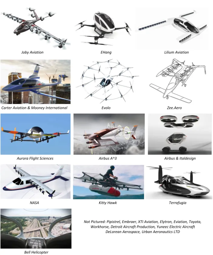
Numerous entrepreneurs and large companies now aim to repeat this business model in large metropolitan areas utilizing networks of small VTOL aircraft. Proponents of ODM Aviation (as the concept is referred to short-hand in this paper) propose that recent advancements in electric propulsion, energy storage and automation will make all-electric, VTOL aircraft available and economically viable by 2020 [1], [2]. Figure 1 presents numerous potential ODM aircraft and developers displaying the wide variety of configurations these vehicles may adopt.
The idea of intra-city, aircraft-based transportation is not new, and in fact was seriously pursued and researched in the United States throughout the 1960’s and 1970’s. The first helicopter air transportation companies carried commercial passengers in 1953, and within a decade scheduled helicopter carriers were in operation in Los Angeles, San Francisco, New York, and Chicago [3]. These companies primarily provided connecting services between major airports, or between an airport and the downtown Central Business District (CBD). Operations grew dramatically during the 1960’s from under 400,000 annual helicopter passengers in 1962 to over 1.2 million passengers in 1967.
O
2
American Institute of Aeronautics and Astronautics
Joby Aviation EHang Lilium Aviation
Carter Aviation & Mooney International Evolo Zee.Aero
Aurora Flight Sciences Airbus A^3 Airbus & Italdesign
NASA Kitty Hawk Terrafugia
Not Pictured: Pipistrel, Embraer, XTI Aviation, Elytron, Eviation, Toyota, Workhorse, Detroit Aircraft Production, Yuneec Electric Aircraft
DeLorean Aerospace, Urban Aeronautics LTD
Bell Helicopter
Figure 1. Selection of companies exploring aircraft for use in ODM Aviation. Potential vehicles range in
configuration from traditional helicopters to distributed electric propulsion, blown-wing concepts, to scaled-up multi-rotor UAS concepts. Vehicles may be powered conventionally or through some percentage of electric power.
3
American Institute of Aeronautics and Astronautics
In addition to these four scheduled helicopter air carriers, over 100 helicopter-based air taxi operators were in business in 1976 providing pre-booked, intra-city charter transportation [4, p. 38]. Perhaps the most well-developed of these operators, a helicopter line named “Air General” set up a network of over 70 heliports in Boston (many in motel parking lots or private greenspaces) and offered a commuter service from 1962 to 1969 carrying over an estimated 100,000 passengers in this period. Air General did not fly scheduled flights, but rather operated with a reservation system that allowed customers to request flights in as few as 30 minutes prior to a desired pickup time [3]. Air General therefore represents the first ODM Aviation company. It operated for nearly a decade, over 50 years before the current generation of aspiring companies anticipate re-entering the market.
Despite initial successes, these early operators were ultimately forced to significantly reduce or terminate operations (effectively ending public, urban air transportation for a half century) due in large part to community acceptance issues, fatal accidents and financial challenges [5]. Simultaneously, numerous studies by the Department of Transportation, NASA, and local authorities [3], [4], [6] found that while VTOL aircraft presented a compelling case to constitute a new form of transportation, reduce congestion, and overcome the geographic constraints of ground mobility modes, their success was hindered by a number of operational challenges including:
Availability of geographically distributed ground infrastructure co-located with areas of customer demand Integration of urban air transportation operations with Air Traffic Control (ATC) and the potential need for
a new, automated ATC system to manage airspace below 3000 ft Murky legal and regulatory jurisdictions for low altitude airspace Acquiring widespread community acceptance of vehicle noise
Lack of a computerized customer booking and demand scheduling system
Despite numerous efforts over the past four decades, intra-city aviation networks continue to be absent at a large scale in the United States. The non-existence of these services suggests that the challenges outlined above, or perhaps other constraints not listened, currently prohibit or discourage sustainable intra-city aviation ventures. While some authors propose that the identified barriers related to community acceptance, noise and demand scheduling may now be lessened or completely overcome through the emergence of distributed electric propulsion aircraft configurations and advanced automation [1], [7], [8], the research presented in this paper investigates if operational constraints persist that may influence the implementation of large-scale ODM Aviation networks in the United States.
While the operational constraints introduced in this paper are not a complete review of all challenges ODM Aviation may encounter, these constraints represent the most significant systems-level challenges for ODM Aviation networks. A companion paper to this publication, Ref. [9], introduces a more detailed review of each prioritized constraint and discusses a set of proposed mitigation approaches. Finally, Ref. [5] documents the full development of the Los Angeles exploratory case study presented in this paper and the subsequent constraint identification process.
II. Methodology
Numerous studies have previously been conducted to review various system-level aspects of ODM Aviation. High fidelity market models were developed to forecast promising demand areas and applications for the new ODM vehicles [7], [10]. Proposed ConOps for ODM Aviation missions were also reviewed to identify various vehicle, noise and infrastructure constraints [8], [11]. Finally, numerous authors explored regulatory and legal factors that may influence the operation of unmanned aircraft systems (UAS) and ODM aircraft at low altitudes [12]–[14].
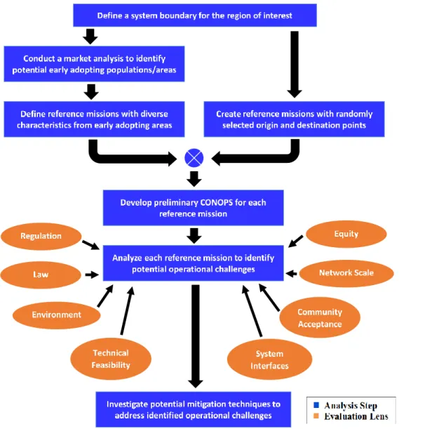
The exploratory case study conducted in this research to assess the operational potential for ODM networks differs from these previous approaches. While each of the above studies conducted an in-depth assessment of ODM Aviation in a single domain (business, operations, or regulations), this research assessed operational potential by holistically reviewing each of these fields in relation to one another, as well as considering social, environmental and system integration factors. Figure 2 presents a flow block diagram of the exploratory approach used in this paper to assess the operational potential of ODM Aviation services in Los Angeles and Southern California.
First, potential early adopting markets of ODM Aviation services were identified in the Los Angeles area using commuting, income, household valuation and current helicopter charter service information. Nine “reference missions” were defined that characterized a diverse set of ODM Aviation requirements in terms of mission range, passenger demand, ground population density, infrastructure availability and airspace interaction, among others. Three additional reference missions were also created with randomly generated origin and destination points to address possible selection bias in the reference mission definition. Any number of reference missions could have been defined
4
American Institute of Aeronautics and Astronautics
or randomly generated, however twelve was deemed a sufficient number to capture the variability of possible ODM mission attributes for the initial case study.
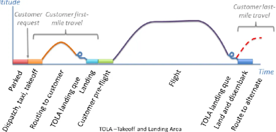
Next, a concept of operations (ConOps) was drafted for each reference mission. The ConOps defined the activities completed by the customer and ODM aircraft from the moment the customer ordered the service to the moment the customer reached their destination. The ConOps therefore included customer ground transportation, aircraft staging and ferrying, customer boarding, flight path planning, air traffic control interaction and aircraft charging, among others visually depicted in Figure 3. The ConOps defined operations from a vehicle agnostic standpoint assuming basic requirements, such as VTOL capabilities, rather than baselining performance on a specific vehicle.
Having defined ConOps for the 12 reference missions, the next analysis step in Figure 2 analyzed each mission through multiple domain “lenses”. Researchers conducting enterprise architecting on large sociotechnical systems found that adopting multiple design perspectives (lenses) effectively reduced complexity and increased the likelihood of uncovering novel factors [15, p. 14]. Adapting this approach for the design of novel ODM technologies and networks, each reference mission’s ConOps was first assessed through the traditional engineering lenses of technical feasibility and regulatory compliance. Next, the ODM Aviation networks were evaluated with respect to numerous
Figure 2. Flow block diagram of the exploratory case study analysis approach. This approach was applied in
5
American Institute of Aeronautics and Astronautics other domains including
community acceptance of operations, environmental impact, and interfaces with related systems including air traffic control, ground infrastructure and ground-based transportation. While this step of the case study provided a holistic view of the potential operational challenges ODM Aviation networks may face, it did not review any individual challenge in significant detail.
Therefore, the final step of the case study approach presented in Figure 2 prioritized the identified
challenges, investigated the key constraints in greater depth, and then evaluated potential mitigation techniques to address binding constraints. Potential mitigation techniques were devised through a variety of approaches. First, proposed mitigation techniques were collected from the literature where available. Secondly, the challenges identified in this research were presented to stakeholders in the ODM Aviation industry who proffered mitigation options based upon their expertise. Finally, inspired by the “backcasting” methodology developed by authors of environmental regulation and technology policy research [16, p. 1051], [17, p. 172], this analysis approach projected the ideal future scenario for ODM Aviation networks as proposed by the industry, and then sought to backcast what mitigation approaches were necessary to achieve that future.
Since the primary purpose of this paper is simply to identify and prioritize the set of operational constraints impacting potential ODM Aviation operations, only a brief evaluation of mitigation techniques reviewed in this final step of the analysis process are introduced below. The companion paper, Ref. [9], contains further details on potential mitigation technologies and opportunities.
III. Los Angeles Case Study
Each step of the exploratory case study approach displayed in Figure 2 is presented in brief below. For a more complete documentation of the Los Angeles case study, please refer to Ref. [5].
A. System Boundary for an ODM Aviation Network in Los Angeles
Los Angeles was selected for the initial ODM Aviation case study due to the expectation that the metropolitan area and surrounding region was uniquely suited as an early adopter market because of its large consumer base, severe roadway congestion, existing helipad infrastructure and mild weather. In order to define explicit boundaries for the case study, four factors were investigated to indicate where (geographically) near-term ODM Aviation services are likely to be provided. The four factors considered were:
1. Commuter transportation flows into the Los Angeles metropolitan area 2. Current helicopter charter services to and from Los Angeles for 12 operators 3. Population density of communities in Southern California
4. Anticipated ODM mission characteristics and aircraft range capabilities
Considering insights from the investigation of these four factors, two distinct mobility patterns were recognized that correspond to different geographic coverage patterns for potential ODM Aviation operations. First, the services of 12 existing helicopter charter outfits and “journey to work” commuter data from the 2006 to 2010 American Community Survey (ACS) revealed the existence of numerous well-defined transportation corridors between major CBDs, outlying residential communities and recreational areas in Southern California [18]. These identified corridors, which represent potential early-adopting inter-urban ODM Aviation opportunities, span between specific population centers and are characterized by a relatively large number of commuters completing geographically similar routes.
Figure 3. Notional aircraft ConOps with indicated passenger interaction phases developed to simulate each reference mission.
6
American Institute of Aeronautics and Astronautics
The second mobility pattern identified is characterized by trips between the Los Angeles CBD, its surrounding residential areas, and major points of interest such as the Los Angeles International Airport, sports venues, or major tourist attractions. These intra-urban ODM Aviation opportunities are typically of shorter geographic distance and represent a more diverse set of potential origin and destination points compared to the relatively well defined corridors of the inter-urban missions.
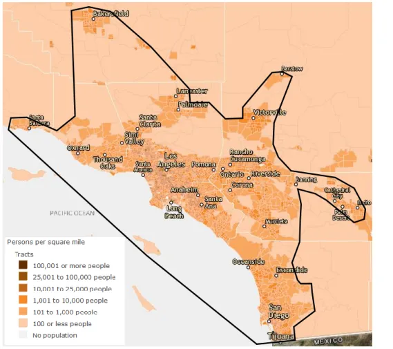
The system boundaries for inter-urban and intra-urban operations in Southern California are jointly presented in Figure 4 overtop a population density map of the region. The irregularly shaped black system boundary contains a majority of the CBDs and densely populated communities of the Southern California megaregion. This boundary also encompasses major existing helicopter charter markets within a roughly 125 mile radius of the Los Angeles CBD.
B. Consumer Demand Estimation and Geographic Locating
In order to define reference missions and their associated ConOps within the Los Angeles region, a general understanding of the potential consumer demand for air-taxi operations was developed. The Los Angeles case study sought to characterize the relative demand for the following mission categories:
1. Daily Commute: an aircraft is utilized during business days to transport individuals between a location near their place of residence to a location near their place of work and vice-versa.
2. Non-Commute Point to Point: an aircraft is utilized to transport individuals on a non-commuter trip between two locations. Such missions may be business trips between two companies, recreation trips to and from the city, or perhaps trips to sporting events, for example. This mission may also involve moving goods rather than individuals (courier service).
Figure 4. System boundary delineating anticipated ODM Aviation network geographic boundaries in Southern California. USA_Population_Density map © 2013 Esri, retrieved from www.arcgis.com.
7
American Institute of Aeronautics and Astronautics
While ODM Aviation services for the non-transportation sector (law enforcement, news gathering, package delivery, etc.) may represent a significant early-adopter market, missions of this type were not considered in this initial analysis.
A consumer’s selection of ODM Aviation as a mobility mode (versus other options available to them) depends upon their unique set of preferences. Oftentimes these preferences are dynamic and vary with the context, or setting, in which the individual is making their decision. By identifying contexts and specific consumer groups in which individuals were more likely to value higher speed transportation despite higher relative service costs, this research identified specific early adopter markets and missions for ODM Aviation. Furthermore, this market identification approach identified specific geographic regions ODM Aviation may initially serve in the Los Angeles region.
For example, individuals traveling long distances or through heavy congestion are likely to express a higher willingness to pay for the increased speed of ODM Aviation. Similarly, it is also probable that individuals traveling to events or popular areas (such as a baseball game or shopping center) expect to encounter significant congestion and may be more likely to desire the capabilities of ODM aircraft. Consumers with high wealth may also be assumed to have a greater willingness to pay for ODM Aviation services. Finally, it was anticipated that consumers with tight timelines or significant consequences for travel delays, such as individuals traveling to airports or hospitals, may express a higher preference for ODM Aviation.
This research sought to corroborate and confirm the potential demand patterns developed from intuition above by examining three main sources of data:
1. Current helicopter charter services were reviewed to identify market demand in the form of existing metropolitan air transportation missions. Furthermore, the current far or charter price supported by the market for these services was evaluated.
2. Census data was examined to identify commuters that experience exceptionally long distance or long duration daily commutes. It was anticipated these individuals may place a higher value on the speed of the transportation mode.
3. Consumer wealth data, gathered through the proxy of home valuation and average household income, was examined to identify wealthy communities that may have a greater willingness to pay for the enhanced value provided by the service.
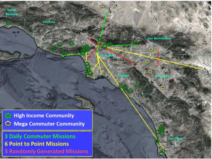
Based upon an in-depth review of these three data sources, 35 high income communities and nine “mega commuting” regions were identified as potential early adopting markets for ODM Aviation services. High income communities were characterized as contiguous census block groups with household income of at least $200,000 [19], or neighborhoods with average home valuations of greater than one million dollars. Communities meeting either of these criteria were considered as potential high income commuter areas.
The mega commuting regions included over 110,000 individuals who travel at least 50 miles over a time period of at least 90 minutes, one-way, each day into Los Angeles or San Diego [20]. The high income communities represent a more sizable potential market and are located in a ring around Los Angeles and in a cluster to the north of San Diego. Together, the high income and mega-commuting communities may be considered as sources and sinks for potential ODM Aviation missions. Figure 5 displays the locations of these areas of these demand centers.
8
American Institute of Aeronautics and Astronautics
C. Reference Mission Definition
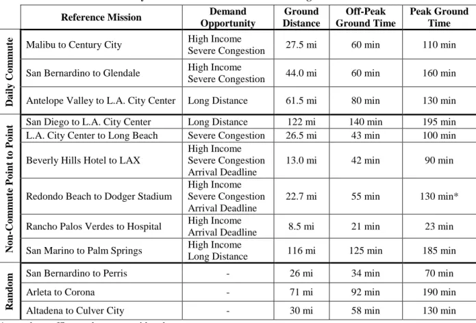
Having completed the first two steps of the exploratory, systems approach presented in Figure 2, the next phase of the case study was to define ODM Aviation reference missions within the system boundary. Considering the high income and mega commuter communities identified in Figure 5 as sources and sinks, as well as considering existing helicopter charter routes, nine reference missions were developed to capture a wide diversity of potential ODM Aviation missions the Los Angeles. These missions represent multiple types of markets, flights of diverse range, duration, demand and airspace congestion, access to varying levels of ground infrastructure, and distinct requirements for flight profiles.
While the first nine of the reference missions were specifically selected to represent anticipated early adopting markets, three additional reference missions were derived from randomly selected origin and destination points. The purpose of these three randomly selected reference missions was to reveal unidentified challenges or opportunities for the operation of ODM Aviation networks that may not have appeared in the reference missions defined solely based on the perceived initially promising markets. The 12 reference missions are pictured in Figure 5 and summarized in Table I.
In addition to simply defining the origin and destination points of the reference missions, a transportation analysis was conducted to ascertain a variety of key features that characterize each reference mission and qualify the market opportunity for ODM aircraft services. A brief summary of the transportation analysis techniques, tools and assumptions is provided in the following sub-sections.
Figure 5. Straight line flight trajectories for the 12 ODM Aviation reference missions considered in the Los
Angeles case study displaying high income commuter and mega commuter communities in seven counties.
9
American Institute of Aeronautics and Astronautics 1. Reference Mission Definition Approach
The first step of defining the reference missions was to choose origin and destination points for the potential ODM aircraft services based upon the likely early adopter markets introduced in sub-section B. A representative address was selected within the chosen origin region (such as in a neighborhood), and the address of the destination was also likewise determined.
The exploratory case study approach sought to evaluate a tractable number of missions that characterized the diversity of operational requirements ODM Aviation networks may face, as opposed to Monte Carlo operations research techniques that may systematically sample thousands of potential reference missions. By strategically selecting a small set of missions that exhibited the range of possible characteristics, then the set of ODM Aviation constraints could theoretically be found with far fewer samples. This research approach therefore devoted energy to deriving a representative set of reference missions on the front end, rather than spending many more resources on the back end of the analysis to evaluate far more samples.
The potential consumer demand for each of the daily commuter reference missions was confirmed through the use of the U.S. Census Bureau Longitudinal Employer-Household Dynamics Origin-Destination Employment Statistics (LODES) 2014 data sets. The LODES data was used to develop a “laborshed” mapping for the reference mission origin area. A laborshed is typically a heat map that displays where workers in a specified employment reference area commute from to get to work. However, for the case of this study the inverse laborshed is of interest to reveal where individuals that reside in a specified area of residence commute to work. It should be noted that the LODES data does not capture the current commuting pattern of every individual living in an area, and therefore the laborshed mappings developed should not be considered as precise market estimations.
The LODES data quantified the magnitude of the potential demand for the reference missions. Furthermore, the inverse laborshed mapping in some cases revealed other “hot spots” where a large number of individuals from the community of interest commuted to for work. These hot spots may represent other high value missions for ODM
Table I. Summary and characteristics of the 12 Los Angeles reference missions.
Reference Mission Demand
Opportunity Ground Distance Off-Peak Ground Time Peak Ground Time Da ily Co mm
ute Malibu to Century City
High Income
Severe Congestion 27.5 mi 60 min 110 min San Bernardino to Glendale High Income
Severe Congestion 44.0 mi 60 min 160 min Antelope Valley to L.A. City Center Long Distance 61.5 mi 80 min 130 min
No n -Co mm ute P o int to P o int
San Diego to L.A. City Center Long Distance 122 mi 140 min 195 min L.A. City Center to Long Beach Severe Congestion 26.5 mi 43 min 100 min
Beverly Hills Hotel to LAX
High Income Severe Congestion Arrival Deadline
13.0 mi 42 min 90 min
Redondo Beach to Dodger Stadium
High Income Severe Congestion Arrival Deadline
22.7 mi 55 min 130 min*
Rancho Palos Verdes to Hospital High Income
Arrival Deadline 8.5 mi 21 min 23 min San Marino to Palm Springs High Income
Long Distance 116 mi 125 min 185 min
Ra
nd
o
m San Bernardino to Perris - 26 mi 34 min 70 min
Arleta to Corona - 71 mi 92 min 190 min
Altadena to Culver City - 30 mi 58 min 130 min
10
American Institute of Aeronautics and Astronautics
Aviation services. These studies were only conducted for the daily commuter missions as the LODES data provided no information on non-commute point-to-point travel.
Next, a ground transportation study was conducted for each reference mission. This study determined the travel time profile for a reference mission assuming it was completed through the use of an automobile (private or commercial). In order to develop this travel profile, Google Maps™ mapping service travel predictions were queried for a single route over the course of a representative day. The results from these queries created an impression of the severity of ground congestion along the reference routes and provided insight into the time dependency of ODM Aviation demand patterns.
The Google Maps™ mapping service has access to a wealth of commuter and point-to-point travel information through GPS tracking. The maps use sophisticated travel prediction algorithms that draw upon official speed limits, recommended speeds, likely speeds based on road type, historical average speed data (dynamically adjusted for time and day), actual travel time from users, and real-time traffic information [21]. Therefore, this tool was assumed to be adequate to develop travel time profiles of sufficient accuracy for this case study. Future studies may seek to develop more accurate travel time profiles and route mappings through the use of aggregated cell phone tracking data, such as shown by Ref. [22] and Ref. [23].
As an additional note, the Google Maps™ mapping service presented only aggregate data. While this was ideal to estimate daily commuter references missions (albeit neglecting variance in congestion due to road conditions such as major accidents or construction), it did not accurately represent the traffic that an individual may expect to encounter for point-to-point travel to non-recurring events such as sporting events. Therefore the travel time profiles presented for the point-to-point reference missions that involve non-recurring events should be viewed as lower bound estimates of travel time as there was likely to be significant additional event congestion.
The final step of the reference mission definition was to identify existing potential takeoff and landing locations for the ODM aircraft. For this analysis, viable current day takeoff and landing locations were considered to have the following traits:
Must be designated as either helicopter landing facilities or airports. Must not be reserved for medical use, such as hospital landing facilities.
May be an emergency helicopter landing facility. Note that these facilities are not approved for commercial operations at this time. It was assumed they could be viable facilities in the near future.
May be a public service helipad, such as a police or firefighter facility, so long as it is not contained within a secure, access controlled facility such as a prison or police station.
May be a private facility, even a facility located in a private compound or rooftop. 2. Example Daily Commute Reference Mission Definition
The Malibu to Century City reference mission captures a potential wealthy commuter market with a ground transportation “choke point.” Malibu is an affluent coastal town west of Los Angeles. Century City is a significant business and cultural satellite city west of Los Angeles and roughly 27 miles east of Malibu. Shown as a purple line in Figure 6, the primary route from Malibu to Century City is to drive the highway 1 on the coast. The primary alternative route nearly doubles the trip distance by passing through the Santa Monica Mountains to highway 101. As a result, highway 1, which has only two lanes in each direction, acts as a choke point that becomes significantly congested during peak traffic periods. Although the reference mission is only 27.5 miles and 40 minutes during low traffic periods, it may take as long as 110 minutes during peak weekday commuting periods; this represents a 175% congestion penalty. The route is therefore considered an “extreme commute” during peak congestion periods.
Table II displays the specifications for the Malibu to Century City reference mission. The mission origin point was chosen within one of the highest value neighborhoods along the coast. The nearest existing helipad is a police, surface-level facility located on the beach 1.3 miles from the mission origin point. The police helipad is not located in a secured facility and therefore was assumed in this analysis as accessible for ODM aircraft operations. The mission destination point is an office building in Century City with an onsite helipad.
11
American Institute of Aeronautics and Astronautics
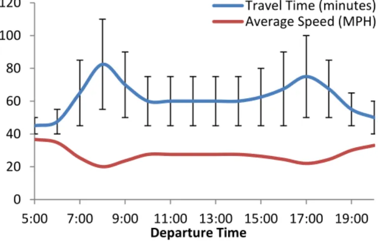
Figure 7 presents the ground transportation study for the Malibu to Century City reference mission. Ground transportation commuting times as predicted by the Google Maps™ mapping service were collected from 5:00 AM until 12:00 PM inbound from Malibu to Century
City, and from 1:00 PM until 8:00 PM outbound from Century City to Malibu. The low and high travel time bound estimates were recorded and an average travel time was estimated. Finally, the average speed of travel for the entire ground transportation mission was estimated by dividing the primary ground route distance by the average trip duration. The diagram is bimodal displaying the morning and evening “rush hour” periods arising from peak congestion on highway 1. Furthermore, the travel time estimation error bounds are quite large (+/- ~50% time) for a majority of the day indicating frequent and severe daily fluctuations in congestion.
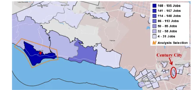
Finally, Figure 8 displays the inverse laborshed developed for Malibu utilizing the
Figure 6. Malibu to Century City reference mission.
© 2016 Google, Map Data: SIO, NOAA, U.S. Navy, NGA, GEBCO, USGS.
Figure 7. Malibu to Century City reference mission travel time and average speed distribution.
0 20 40 60 80 100 120 5:00 7:00 9:00 11:00 13:00 15:00 17:00 19:00 Departure Time
Travel Time (minutes) Average Speed (MPH)
Table II. Malibu to Century City reference mission specifications. Type: Wealthy Commuter, Extreme Commute, Choke Point Origin: 7006 Birdview Ave, Malibu, CA 90265
2016 Origin Helipad: L.A. Police Helipad: 5 Zuma Beach Access Rd, Malibu, CA 90265 Destination: Century City: 1901 Avenue of the Stars, Los Angeles, CA 90067 Destination Helipad: on-site rooftop helipad
Driving Distance: 27.5x mi primary ground 42.5 mi secondary ground
12
American Institute of Aeronautics and Astronautics
U.S. Census Bureau LODES data. Darker blue regions on the map represent census tracts where more workers from within Malibu the residential area (highlighted in an orange polygon) travel to work to each day. As can be seen in Figure 8, the largest number of workers remain in Malibu. The census tracts adjacent to Malibu also appear to have a significant number of workers who commute to them each day. Expanding outwards, there are a variety of census tracts above the Santa Monica Mountains and within Santa Monica that have between four and 31 jobs. However, Century City stands out as a darker shaded census tract indicating it is one of the more common worker destinations for Malibu residents who travel beyond their own community. Upon investigation, it was found that 43 individuals conducted a daily commute from Malibu to Century City.
D. Reference Mission ConOps Definition
Two separate, interacting ConOps were considered in this research to describe the actions of both the aircraft and the customers in an ODM network. Figure 3 displayed a diagram of the notional aircraft ConOps for a generic ODM Aviation mission and the associated customer actions. Table III presents a simplified seven step mission ConOps that describes the phases of a generic ODM Aviation mission. While any single reference mission may not require an aircraft or customer to conduct all of the steps outlined in Figure 3 or Table III, these ConOps capture the possible set of nominal operations that may be required for such a mission.
“TOLA” in Table III stands for “Takeoff and Landing Area,” referring to any location an ODM aircraft may depart from or arrive at. Depending upon the VTOL capabilities of future aircraft, the generic term TOLA may represent a wide variety of infrastructure ranging from an airport to a heliport or even perhaps a parking lot or empty road. Numerous terms for novel takeoff and landing infrastructure for ODM aircraft have been proposed in the literature; this research documented
vertiport, vertipad, pocket airport, skypark, sky node and sky port. While each of these terms could potentially be used to describe ODM ground infrastructure, this research sought to remain as general as possible and recognize that unimproved areas such as greenspace or roadways could
Figure 8. Malibu inverse laborshed with the Century City census tract indicated in red. Image developed
with the U.S. Census Bureau OnTheMap application. http://onthemap.ces.census.gov/.
Century City.
Figure 1. Malibu inverse laborshed with the Century City census tract indicated in red. Image developed with the U.S. Census Bureau OnTheMap application. http://onthemap.ces.census.gov/.
San Bernardino to Glendale City Ce
Table III. Notional mission ConOps for ODM Aviation.
ConOps Step Description
initiation Customer submits a travel request 1 Aircraft routed to nearest TOLA
2 Customer takes ground transportation from origin to TOLA 3 Customer arrives at TOLA and is prepared for takeoff 4 Flight segment
5 Aircraft arrives at destination and customer disembarks 6 Customer takes ground transportation to final destination 7 Aircraft recharges batteries
13
American Institute of Aeronautics and Astronautics
potentially serve as an operations area for ODM aircraft. Therefore, the term takeoff and landing area was chosen to describe any such area.
E. Reference Mission Operational Challenges Identification
The aircraft and mission ConOps outlined above were applied to each of the twelve reference missions to develop hypothetical mission timelines and identify potential operational challenges that may arise in the near-term implementation of ODM networks. Potential challenges included any situation that could influence the feasible operation of an ODM Aviation network. While some challenges were perhaps trivial in light of emerging technologies and proposed mitigation approaches, this research sought to be thorough in identifying the factors that could influence the operational potential of ODM Aviation networks. The ConOps evaluation for the Malibu to Century City reference mission is presented in brief below as an example of the operational challenges identification process.
1. ConOps Step 1: Aircraft Routed to the Nearest TOLA
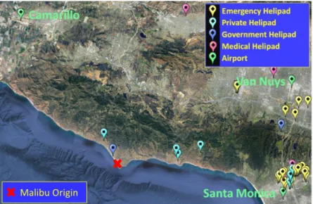
Once the customer travel request is received by the ODM service provider, an available TOLA near the customer must be selected as the pickup point. If an aircraft is not on-site at that specific pickup TOLA, then one must be routed to the location from a nearby staging area or operation. As an example of the current availability of ground infrastructure to support ODM aircraft operations, Figure 9 displays the existing TOLA infrastructure surrounding the Malibu origin point. While future ODM aircraft and operators may be certified to land and takeoff from unimproved locations (such as a greenspace or parking lot), this initial review of the ConOps restricted potential TOLAs to those that meet current-day operating regulations; this was done to identify the near-term challenges related to infrastructure.
The closest TOLA to the origin point is a L.A. police helipad (indicated with a dark blue pin in Figure 9) located 1.3 miles from the origin point. The TOLA is on the beach and has a low protective fence surrounding it. There is a public access road with available street parking. There are three other private-use heliports within ten miles of the origin.
While the government helipad was selected as the primary TOLA for this reference mission, the availability of the facility for ODM operations is not guaranteed as emergency operations have priority access to the facility. Furthermore, the next three nearest helipads to the origin point are privately owned suggesting that ODM operators may have to negotiate with each owner for use of these facilities. Finally, all four helipads in the Malibu area have
only one touch-down and liftoff area (TLOF) with no additional aircraft parking capacity beyond a single vehicle on the TLOF. This means that if an aircraft is conducting an operation at a TOLA or is parked on-site, then that TOLA is not available for use by any other vehicle in the network.
The lack of currently available TOLAs in the Malibu area prompted the identification of the first ODM Aviation operational challenge concerning how to resolve TOLA congestion and priority use. This operational challenge considers how priority will be assigned among operators (as well as police and EMS services), how airspace congestion in the immediate TOLA surroundings shall be managed, and who is responsible for these services. The Malibu to Century City reference mission represents a wealthy commuter community where demand is likely to be concentrated within an hour or two hour period during the morning and evening commutes. There is only one convenient TOLA in the immediate surroundings of the origin point and it has the capacity for only a single aircraft.
Figure 9. Current TOLA infrastructure near Malibu with
multi-vehicle capacity airports labeled in green.
© 2016 Google. Map Data: CSUMB SFML, CA OPC, USGS.
14
American Institute of Aeronautics and Astronautics
It is therefore likely there may be congestion at the TOLA as numerous ODM aircraft attempt to pick up customers during the morning rush hour or drop them off in the evening.
A second potential ODM Aviation challenge that arose concerned where ODM aircraft are staged. A key aspect of providing effective ODM services is having the network assets (vehicles) geographically distributed near areas of potential demand. While automobile ODM networks often have vacant vehicles driving on the roads in the network at all times due to the relatively low cost of operation of automobiles, it is unlikely this approach will be feasible for ODM Aviation networks as the operating costs of flight are significantly higher. Therefore, ODM aircraft must be staged, or parked, at TOLAs relatively near the anticipated areas of demand.
In the case of the Malibu to Century City reference mission, the first staging option would be to stage an aircraft on the police TOLA. This approach would only allow one aircraft to be on station at a time, and it would make the TOLA unavailable for the rest of the network. Beyond reducing the capacity of the network, it is unlikely that a vehicle would be allowed to loiter on the helipad for extended periods as the facility must be available for emergency police and medical services.
A second potential vehicle staging approach would be to position multiple vehicles at the private heliports surrounding Malibu. There are four private heliports within 12 miles of the police facility. ODM aircraft could more easily be stationed at these facilities as they are not reserved for emergency operations. However, the proximity of these four helipads was not considered to fully mitigate the aircraft staging challenge as it is possible the private helipad owners may not tolerate an ODM aircraft loitering for indefinite periods of time on their property.
A third approach to vehicle staging for the Malibu to Century City mission is to stage numerous vehicles at an off-site location. Figure 9 labeled in green writing the nearest existing facilities with capacity for multiple vehicles; these facilities are exiting airports located roughly 20 nautical miles (nmi) away. If new infrastructure development were considered, then a multi-vehicle staging facility could likely be developed in vacant space much closer to Malibu. Similarly, special use locations such as parking lots or fields could also be potentially used as near-term aircraft staging areas.
2. ConOps Step 2: Customer Takes Ground Transportation from Origin to TOLA
Two potential challenges were identified during the review of this step of the ConOps. First, the TOLA proximity to the customer origin point was recognize as a challenge for a majority of the reference missions. As seen in Figure 9 and discussed above, the lack of existing, geographically well-distributed TOLAs in Malibu may not only create aircraft staging issues, but may also reduce the demand for ODM Aviation services due to cumbersome or long first mile/last mile ground transportation requirements.
Secondly, if customers chose to drive a personal vehicle to the TOLA, then private vehicle parking at these facilities may be a challenge. Traditional multi-modal operations such as subway and bus systems provide extensive parking options at perimeter stations, however these operations are beginning to adopt ride sharing services.
3. ConOps Step 3: Customer Arrives at the TOLA and is Prepared for Takeoff
Once a customer arrives at the TOLA a variety of potential activities may be necessary in order to prepare them for the flight. These activities may include:
Customer identity certification
Security scan (not currently required for aircraft under 12,500 lbs) Customer access to the TOLA touch-down and liftoff area Customer and luggage loading into the aircraft
FAA pre-flight safety review Aircraft startup and takeoff
Completing some or all of these tasks for the Malibu mission may require a non-trivial amount of time, especially if there is no on-site personnel and the pilot is required to exit the vehicle (presumably shutting it down) to conduct the preflight activities. On-site personnel may dramatically speed up the preflight process, however loading the aircraft and takeoff will still require some aircraft time on the pad. As a result, a potential operational challenge for ODM Aviation is the duration of the aircraft turn-time on the TOLA. The aircraft turn-time is interconnected with the availability of the TOLA and influences potential ODM network congestion in the region.
15
American Institute of Aeronautics and Astronautics
While physically accessing the TOLA was not anticipated to be a challenge for the Malibu mission due to the surface level nature of the police helipad, it was identified that customer access to the TOLA was a challenge for many other reference missions. Much of the existing helipad infrastructure is located on the rooftops of private buildings, inside private business compounds or in areas otherwise inaccessible to customers without an escort or access to private or secured areas.
Finally, a third potential operational constraint that is closely related to the customer access to the TOLA is the safety and security of the TOLA. Aircraft operations involve large machinery that frequently has exposed propellers and other hazards. Not only must customers be protected while accessing the TOLA for and operation, but bystanders must also be prevented from entering the area and being exposed to hazards. There may also be the concern of ensuring security from individuals who may seek to interfere with ODM Aviation operations at the TOLAs.
4. ConOps Step 4: Flight Segment
In order to identify potential operational challenges arising from the flight segment of an ODM mission, three potential fight trajectories from Malibu to Century City that interacted with different airspace, aircraft traffic and ground populations were examined.Based upon these three flight profiles, three potential challenges for ODM aviation were identified and are discussed below.
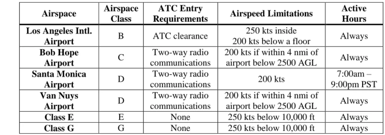
The first challenge concerned how ODM aircraft interact with ATC and access controlled airspace. Flight near, under or through the various classifications of controlled, uncontrolled and special purpose airspace may place requirements on ODM operators such as ATC clearance, equipage or procedural requirements as summarized in Table IV.
In the case of the Malibu to Century City reference mission, between 7:00am and 9:00pm PST all three considered flight profiles required ATC permission to enter the Santa Monica Class D airspace as shown in Figure 10. Since Century City is located within this surface-level airspace, there is no possible flight profile that could complete the mission without ATC contact. ATC interaction was perceived as a potential challenge because as ODM Aviation networks increase in scale, their need for low altitude ATC services may substantially increase compared to the volume of flights handled today by air traffic controllers. As a result, the workload may exceed the current system’s capacity to support. If this were to occur, an air traffic controller may not permit some ODM operations to enter controlled airspace such as the Santa Monica Class D airspace. Furthermore, if ODM aircraft become autonomously flown, there are currently no standards or approaches for an autonomous pilot to request airspace access.
The second ODM Aviation challenge from the flight phase of the mission concerned how ODM aircraft will fly safely with increased densities of vehicles in an airspace. Currently, flight densities in most areas are relatively low. In convergence points where aircraft operations come together, either ATC is responsible for providing separation or special operating procedures and communications frequencies have been established to support self-separation. However, ODM Aviation networks may introduce hundreds to thousands of new flights into some metropolitan airspace thereby significantly increasing flight density.
Beyond interactions with other ODM aircraft, GA aircraft, and commercial aircraft, ODM Aviation will also operate at low altitudes in areas where commercial and private UAS are likely to be prevalent. UAS represent an emerging challenge for the safe operation of aircraft. The FAA recorded 1200 incidents of UAS close calls with
Table IV. Characteristics of airspace near the Malibu to Century City reference mission.
Airspace Airspace
Class
ATC Entry
Requirements Airspeed Limitations
Active Hours Los Angeles Intl.
Airport B ATC clearance
250 kts inside
200 kts below a floor Always
Bob Hope
Airport C
Two-way radio communications
200 kts if within 4 nmi of
airport below 2500 AGL Always
Santa Monica Airport D Two-way radio communications 200 kts 7:00am – 9:00pm PST Van Nuys Airport D Two-way radio communications 200 kts if within 4 nmi of
airport below 2500 AGL Always
Class E E None 250 kts below 10,000 ft Always
16
American Institute of Aeronautics and Astronautics commercial aircraft in 2015,
and a majority of these incidents occurred in controlled airspace near airports where UAS are not permitted to fly without ATC approval. While the FAA’s LAANC program may simplify UAS approval for flight in controlled airspace and increase UAS operator participation, it does not explicitly consider UAS interactions with increased low altitude ODM air traffic.
The final ODM Aviation challenge from the flight phase of the mission concerns addressing noise annoyance
to bystanders created by ODM aircraft operations. ODM aircraft are proposed to conduct frequent operations within communities or to business locations rather than at airports. Helicopter and aircraft noise has been a significant challenge for L.A. airports and helicopter companies having previously attracted U.S. congressional-level action [24]. New ODM operations are therefore likely to face significant resistance if bystander noise exposure is not addressed. 5. ConOps Steps 5 & 6: Aircraft Arrival at TOLA and Customer Ground Transport to Destination
The arrival of the aircraft at the destination TOLA illuminated many of the challenges already identified through ConOps steps 2 and 3. However, one additional challenged was identified concerning how full-electric propulsion reserve range requirements will be defined with respect to alternative safe landing locations. Although an impending re-write to Part 23 of the Federal Aviation Regulations may provide a pathway for the certification of commercial hybrid-electric and electric small (<19 passenger) aircraft, significant research may be necessary to reliably report battery charge depletion and set appropriate safety standards for energy reserve requirements.
No additional challenges were identified from the last mile ground transportation mission phase. 6. ConOps Step 7: Aircraft Recharges Batteries
ODM aviation is proposed to be enabled by quieter, more efficient electric propulsion technologies. However, due to the low specific energy density of batteries compared to chemical fuels, aircraft charging must occur more frequently and presents a new challenge for network operations. Ref. [5] displayed that with current battery technologies and advanced vehicles the maximum range of full-electric aircraft may be as much as 175 miles (with takeoff weights comparable to conventional vehicles). If a 20% range penalty is assumed account for the hovering, takeoff, climb and landing segments of the short range Malibu mission, then a full-electric ODM aircraft could fly roughly 140 miles between recharge. This range estimate enabled roughly two round trip missions between Malibu and Century City, or about an hour of continuous operation, before charging would be necessary. Although not perceived as a challenge for hybrid-electric or conventionally powered ODM aircraft, aircraft charging was identified as a potential challenge for ODM Aviation relying upon full-electric aircraft.
The time necessary for electric aircraft charging is subject to great uncertainty with current technologies. If aircraft are equipped with swappable batteries, charging could take only a few minutes. However, if the batteries cannot be swapped then charging could take much longer. Considering electric cars as a proxy, the state of the art Tesla Model S has roughly a 300 mile range and can fully recharge from a standard wall outlet in about 5.5 hours, or from a special “super charging” station in a little over an hour [25]. Removing aircraft from the network for an hour of recharge per roughly every hour of flight would significantly increase the number of aircraft necessary to provide reliable ODM aviation services. It should be noted that emerging charging capabilities show promise to reduce charge time below 20 minutes.
Figure 10. Controlled airspace in proximity to the Malibu to Century City reference mission (airspace altitude boundaries indicted in MSL).
17
American Institute of Aeronautics and Astronautics
F. Potential Challenges Resulting from Network Interaction of ConOps
Beyond the ConOps for a single mission, some of the greatest challenges ODM Aviation faces became apparent when the operations of the whole ODM network were considered. This section introduces two of these challenges with relation to the Malibu to Century City mission.
The Malibu to Century City reference mission represents a “daily commuter” mission. This means that while point-to-point demand to and from Malibu may exist at all times of the day, there is likely to be a peak period of demand in the morning corresponding to the commute to work rush hour. A peak period of demand may place strain on an ODM aviation network as it requires numerous aircraft be available in the same geographic location at roughly the same time.
In addition to high TOLA congestion during peak demand periods, commuter travel is also likely to be directional where all individuals are moving from Malibu to Century City, and not vice-versa. These two attributes of the daily commuter demand patterns present geographic balancing of ODM network assets as another challenge for ODM Aviation. The aircraft in the ODM network may become imbalanced with demand as aircraft complete missions in Century City and do not have customers returning to Malibu. To balance the network these vehicles must take non-revenue, or “deadhead” flights to return to the customers in Malibu. Deadhead flights increase operational costs raising fairs and reducing the serviceable addressable market.
A second network challenge for ODM Aviation is the route capacity, which was identified to be dependent upon the available ground infrastructure, aircraft turn-time during loading (embarkation) and unloading (disembarkation), vehicle load factor, and vehicle capacity. Table V displays the time estimation for each mission leg and the total duration of the Malibu to Century City mission. This estimation assumed the ground transportation and aircraft assets were available and initially positioned onsite to instantly meet a customer request. Therefore this estimation was considered a lower-bound time estimate as in actual operation the ground transportation assets (automobiles) would require time to travel to the origin to pick up the client, and the ODM aircraft would likely have to transit to the Malibu helipad causing further delays.
The average one-way mission duration for an ODM aircraft from Malibu to Century City was assumed to be 15.5 minutes (embarkation, flight and disembarkation) as shown in Table V. The return trip was assumed to carry no passengers and therefore estimated to require 7.5 minutes. Under these assumptions, the round trip time
for a single ODM aircraft carrying passengers from Malibu to Century City was roughly 23 minutes. The morning rush hour was shown in Figure 7 to last from roughly 7:00am until 9:00am. Therefore, in two hours a single ODM aircraft could complete five round trip missions from Malibu to Century City if no battery recharge time was necessary and the aircraft did not return to Malibu on the final trip.
Neglecting aircraft passenger capacity and load factor, the maximum capacity of the Malibu to Century City route is therefore dependent upon the availability of ground infrastructure in Malibu and the turn-time of the aircraft. The analysis in Table V assumed that each aircraft had a turn-time of five minutes on the ground during embarkation and a turn-time of three minutes on the ground during disembarkation. Furthermore, it was assumed that an additional 60 seconds was required for transition to allow for the departing aircraft to lift off and clear the airspace in proximity to the TOLA and for the next to enter the airspace and prepare for landing.
With these turn-time assumptions, a single aircraft mission therefore occupies the Malibu police helipad for roughly six minutes. This implies that the maximum possible throughput for the helipad (and therefore the reference mission) is roughly ten flights per hour.
Figure 11 displays a notional network ConOps for the reference mission during the first forty-five minutes of the two hour peak period. The utilization of the two helipads (one in Malibu and the other in Century City) is shown under the assumption that there was sufficient demand to operate the Malibu facility at maximum capacity for the whole period. For this analysis it was assumed the flight leg of the mission was an even eight minutes. While one aircraft
Table V. Malibu to Century City mission segment details. Mission Segment Distance (mi) Time (min) % of Avg. Total Time
Ground Transport 1.3 6 27.9% Embarkation 0 5* 23.3% Flight 23.7 – 28.8 7.22 – 7.77 34.9% Disembarkation 0 3 14.0% Ground Transport 0 0 0% Total: 25 – 30.1 21.22 – 21.77 -
18
American Institute of Aeronautics and Astronautics
was assumed to be pre-positioned at the Malibu helipad, the other three aircraft considered were assumed to be staged at Santa Monica Airport which is roughly a seven minute flight from the Malibu TOLA.
With these assumptions, the ODM aviation network could achieve a maximum capacity of approximately 20 flights to Century City in the two hour peak period utilizing four aircraft. If aircraft charging were considered, then eight aircraft would be required to achieve this maximum throughput. The total passenger throughput during this period depends upon the load factor and capacity of the aircraft. A potential benefit of peak congestion periods is that customers could be “pooled” to share a single vehicle thereby splitting costs and increasing load factor. To increase route capacity further, additional ground infrastructure must be developed in Malibu.
The maximum aircraft throughput for a single-pad TOLA (such as a helipad) directly depends upon the aircraft turn-time. For this preliminary analysis, a relatively conservative total turn-time of five minutes was assumed for takeoff operations to facilitate the activities outlined in ConOps step 3 above. However, with support from ground personnel or automation that conducts these customer activities before the aircraft arrives, the turn-time may be significantly reduced. During operations in the 1970’s, New
York Airways allocated three minutes for the turnaround of a 30 passenger Sikorsky S-61 helicopter [26]. Furthermore, helicopter tour operators have displayed turn-times as little as one minute.
Considering the wide variability of potential ODM aircraft turn-time and the notion that it may depend upon factors such as weather conditions, ground staff and passenger capabilities, the aircraft throughput for a single-pad TOLA was studied as a function of turn-time. Figure 12 displays the aircraft throughput capacity for a single-pad TOLA for turn-times of 30 seconds up to 10 minutes. An additional 60 seconds was added to each turn-time to account for the transition of the vehicles and time for rotor vortex dissipation. Figure 12 indicates that large network throughput gains may be possible by reducing the turn-time of aircraft on the TOLAs. This is especially pronounced if turn-time is reduced below two minutes.
IV. Discussion of Potential Challenges for ODM Aviation
The walk-through review of the Malibu to Century City reference mission in sub-section E identified 15 potential operational challenges for ODM Aviation. Furthermore, a consideration of ODM Aviation network factors in sub-section F identified an additional two challenges concerning network load balancing and route capacity.
The approach presented for the Malibu to Century City reference mission was applied to the other 11 reference missions in an effort to identify additional challenges. It was hypothesized that the variability between the reference
Figure 11. ODM Aviation ConOps diagram for the Malibu to Century City network assuming maximum route capacity and no aircraft charging.
Time Step (minutes): 0 1 2 3 4 5 6 7 8 9 10 11 12 13 14 15 16 17 18 19 20 21 22 23 24 25 26 27 28 29 30 31 32 33 34 35 36 37 38 39 40 41 42 43 44 45 46 47 48 49 50 51 52 53 54 55 56 57 58 59 60 61 Malibu Helipad:
Century City Helipad: Aircraft 1: Aircraft 2: Aircraft 3: Aircraft 4: Vacant Disembarkation Hovering Parked
HELIPAD OPS VEHICLE OPS
Occupied TOLA Embarkation
Occupied Airspace Flying
Figure 12. Dependence of single-pad TOLA throughput on aircraft turn-time.
0 5 10 15 20 25 30 35 40 45 0 2 4 6 8 10 Aircraf t Th ro u gh p u t Per H o u r
19
American Institute of Aeronautics and Astronautics
missions in terms of range, passenger demand, airspace interaction, ground infrastructure access and flight profile requirements, among other factors, may reveal additional potential challenges. It was also anticipated that some challenges would appear in a higher percentage of the reference missions, and that these should be considered more thoroughly as pervasive constraints for ODM Aviation operations.
The review of the 11 additional reference missions identified two further challenges that were not present for the Malibu to Century City mission. These included how a customer physically gains access to a TOLA (which was perceived to be especially difficult for rooftop facilities), and how physically close a TOLA was to the customer’s destination. Interestingly, the randomly defined reference missions did not reveal any new challenges that were not already identified in the other nine reference missions. This indicated to the author that the diversity of missions defined from the promising markets were not necessarily biased towards operations that would be easier to implement than any other arbitrary mission.
Finally, the projected degree of severity of the identified challenges varied widely between the different reference missions depending upon their characteristics. In particular, one of the most influential factors was the type and location of the nearest available TOLAs. This factor directly or indirectly influenced 12 of the identified challenges. Secondly, it was found that nearly all the missions experienced all three of the challenges from the flight phase of the mission; these challenges were ATC integration, the safety of flight in proximity to other aircraft, and aircraft generated noise. Finally, all the reference missions faced the fundamental technology challenge of aircraft charging.
Taken as a whole, the 12 reference missions of the Los Angeles ODM Aviation case study revealed a total of 20 potential operational challenges. These challenges are presented as questions in Table VI and associated with the mission ConOps step from which they were derived.
Table VI. Potential ODM Aviation operational challenges.
Mission ConOps Step Potential Operational Challenge
0 Customer submits a travel request None
1 Aircraft routed to nearest TOLA 1. Where are ODM aircraft staged?
2. How is TOLA congestion and priority handled? 2 Customer takes ground transport
from origin to TOLA
3. Where are private automobiles parked?
4. How close is a TOLA to the customer origin location?
3 Customer arrives at TOLA and is prepared for takeoff
5. How does a customer access the TOLA?
6. What is the turn-time for the aircraft at the TOLA? 7. How is TOLA safety and security provided?
4 Flight segment
8. How do ODM aircraft interact with ATC to access controlled airspace?
9. How do ODM aircraft fly safety with increased densities of vehicles in the airspace, particularly UAS?
10. How do ODM Aviation address noise annoyance to bystanders?
5 Aircraft arrives at destination and customer disembarks
11. How is TOLA congestion and priority handled?
12. Is an alternative safe landing location available and what are the energy reserve requirements?
13. How does a customer egress from the TOLA? 14. What is the turn-time for the aircraft at the TOLA? 15. How is TOLA safety and security provided? 6 Customer takes ground transport
to final destination 16. How close is a TOLA to the customer destination? 7 Aircraft recharges batteries 17. What is the required time for aircraft charging?
~ ODM network-wide operations
18. How is the geographic balancing of ODM aircraft handled to meet demand?
19. How is route capacity managed to meet demand?
~ Externality impacts
20. Will local governments restrict ODM Aviation operations or markets due to socio-economic segregation and reduced transportation revenues?