HAL Id: tel-01748772
https://hal.univ-lorraine.fr/tel-01748772
Submitted on 29 Mar 2018HAL is a multi-disciplinary open access archive for the deposit and dissemination of sci-entific research documents, whether they are pub-lished or not. The documents may come from teaching and research institutions in France or abroad, or from public or private research centers.
L’archive ouverte pluridisciplinaire HAL, est destinée au dépôt et à la diffusion de documents scientifiques de niveau recherche, publiés ou non, émanant des établissements d’enseignement et de recherche français ou étrangers, des laboratoires publics ou privés.
Orogenic type gold distribution along major archean
fault zones : numerical modelling in the Abitibi Belt
Olivier Rabeau
To cite this version:
Olivier Rabeau. Orogenic type gold distribution along major archean fault zones : numerical modelling in the Abitibi Belt. Other. Institut National Polytechnique de Lorraine, 2009. English. �NNT : 2009INPL073N�. �tel-01748772�
AVERTISSEMENT
Ce document est le fruit d'un long travail approuvé par le jury de
soutenance et mis à disposition de l'ensemble de la
communauté universitaire élargie.
Il est soumis à la propriété intellectuelle de l'auteur. Ceci
implique une obligation de citation et de référencement lors de
l’utilisation de ce document.
D'autre part, toute contrefaçon, plagiat, reproduction illicite
encourt une poursuite pénale.
Contact : [email protected]
LIENS
Code de la Propriété Intellectuelle. articles L 122. 4
Code de la Propriété Intellectuelle. articles L 335.2- L 335.10
http://www.cfcopies.com/V2/leg/leg_droi.php
DISTRIBUTION DE L’OR DE TYPE OROGÉNIQUE LE
LONG DE GRANDS COULOIRS DE DÉFORMATION
ARCHÉENS : MODÉLISATION NUMÉRIQUE SUR
L’EXEMPLE DE LA CEINTURE DE L’ABITIBI
THÈSE
présentée et soutenue publiquement le 9 novembre 2009 pour l'obtention du
Doctorat de l'Institut National Polytechnique de Lorraine - Spécialité Géosciences
Doctorat en Ressources Minérales de l’Université du Québec à Montréal
Par
Olivier RABEAU
Composition du Jury :Rapporteurs : Alain TREMBLAY, UQAM
Christian MARIGNAC, CRPG
Examinateurs : Jacynthe POULIOT, U. Laval
Helmut SCHAEBEN, U. Freiberg
Directeurs : Michel JÉBRAK, UQAM
Alain CHEILLETZ, CRPG
Invité : Jean Jacques ROYER, CRPG Institut National Polytechnique de Lorraine
École Nationale Supérieure de Géologie École doctorale RP2E
Université du Québec à Montréal Département des Sciences de la Terre et de l’Atmosphère
Remerciements
Je tiens avant tout à remercier Alain Cheilletz et Michel Jébrak qui ont dirigé mes travaux et m’ont fourni de précieux commentaires tout au long de cette thèse. Je remercie aussi grandement Jean-Jacques Royer pour ses conseils, et Marc-Olivier Titeux qui m’a beaucoup aidé lors de mes travaux de modélisation géomécanique. Merci aussi à Marc Legault qui m’a permis de démystifier la géologie du Sud de l’Abitibi et la métallogénie aurifère, à Guillaume Caumon qui m’a conseillé sur mes travaux de modélisation et à Anne-Laure Tertois de chez Paradigm qui m’a aidé à générer mon Solid Model
Cette thèse a été possible grâce à Denis Bois, directeur de l’URSTM-UQAT, qui a cru en moi et qui a tout mis en œuvre pour que je puisse entreprendre et mener à terme ce travail. Je tiens à le remercier pour sa confiance, son soutien et la liberté d’action qu’il m’a donnée. Je tiens aussi à remercier l’UQAT, le réseau DIVEX et le Ministère des ressources naturelles et de la Faune secteur mines qui m’ont donné le support technique et financier pour entreprendre ce travail.
Une reconnaissance particulière va à Robert Marquis qui a cru en mes capacités et qui m’a convaincu qu’il était possible de faire une thèse tout en ayant des enfants (tu avais tout de même embelli l’affaire !). Merci à l’équipe de l’UQAT et particulièrement à Francine (PB), ma coéquipière, qui m’a démarré en modélisation géologique et qui a été pour moi une vraie défricheuse. Merci aussi à Jean Goutier avec qui j’ai discuté de nombreuse fois de géologie abitibienne et de sombréro. Je
tiens aussi à remercier les autres gens du secteur Mines du MRNF (passé et présent) avec qui je travaille quotidiennement : Pat, Gabriel, Charles, Sylvain, Ali, Émilie, Claude, Johanne, Daniel, Serge, Pierre R, Hannafi, Prof. Marc, Jean, Mélanie, Lucie, Fabien, Ginette, les 2 Pierre de Montréal et François.
L’accueil chaleureux que j’ai reçu en France ne peut passer sous silence. Chacun de mes séjours de travail a été marqué par une ambiance remarquable. J’y ai côtoyé des personnes que je ne suis pas près d’oublier. Mille fois merci à Alain et Chantal avec qui j’ai passé de merveilleux moments d’un côté de l’Atlantique comme de l’autre. Leur gentillesse, leur générosité et leurs attentions ont permis à notre famille de se sentir chez soi de l’autre côté de l’océan. Ils nous ont reçus dans leur demeure et initiés à la réalité française ainsi qu’aux subtilités de la cuisine gauloise. Je n’ai connaissance d’aucun autre directeur de recherche ayant passé sa soirée de Noël à jouer de l’accordéon à une petite fille de 18 mois afin permettre à son étudiant daller assister sa femme à son accouchement. Je me considère chanceux et privilégié que nos chemins se soient croisés, je leur suis très reconnaissant pour tout ce qu’ils ont fait pour moi. Pierre et Marc-O, merci pour les quelques discussions sérieuses qu’on a pu avoir, mais surtout pour m’avoir fait rire et passer des moments inoubliables chez vous. J’espère avoir la chance de vous faire apprécier mon pays comme vous m’avez fait apprécier le vôtre et je vous souhaite beaucoup de bonheur dans l’avenir. Merci aussi aux gens de l’équipe Gocad avec qui j’ai aussi passé de bons moments : Guillaume, Sarah, Anlor, Tobias, Manu, Luc, Christian, Pauline et tous les autres que j’ai moins bien connus faute de temps. Merci aussi aux dévouées Fatima et Mme
Cugurno qui ont été très patientes avec moi et qui m’ont aidé à démêler la bureaucratie universitaire française.
Merci aussi aux compagnies minières qui ont participé au projet en me permettant d’avoir accès à leurs données et à Paradigm et Mira Géoscience qui m’ont donné accès aux licences des logiciels.
Ce travail n’aurait jamais été possible sans le support de ma famille. Clément et Éliane sont arrivés dans ce monde alors que leur père était déjà inscrit en thèse, leur joie de vivre et leur amour se sont avérés être une contribution essentielle à son achèvement. Merci à mes parents pour leur appui. Finalement, un énorme merci à ma blonde, Marie-Odile, qui a accepté de m’épauler et de me suivre dans cette aventure avec les sacrifices qui y étaient rattachés. Son soutien, son amour et sa présence à mes côtés ont été inestimables et irremplaçables.
TABLE DES MATIÈRES
REMERCIEMENTS... III
LISTE DES FIGURES ... X
LISTE DES TABLEAUX ... XV
CONTRIBUTION DES AUTEURS ...XVI
INTRODUCTION... 1
Époque de mise en place de l’or de type orogénique... 4
Références... 6
CHAPITRE 1: SPATIAL DISTRIBUTION OF OROGENIC GOLD
DEPOSITS ALONG MAJOR ARCHEAN FAULTS ... 10
1.1 Introduction générale ... 10
1.2 Abstract... 14
1.3 Introduction... 15
1.4 Geological setting ... 17
1.6 Available Data and Methodology ... 20
1.6.1 Validation of the spatial distribution ... 27
1.7 Discussion ... 29
1.7.1 Regional potential mapping using structural failure location... 31
1.8 Conclusions... 34
1.9 Acknowledgements ... 34
1.10 References... 35
1.11 Annexe 1... 41
CHAPITRE 2: GOLD POTENTIAL OF A HIDDEN ARCHEAN
FAULT ZONE: THE CASE OF THE CADILLAC-LARDER LAKE
FAULT ... 43
2.1 Introduction générale ... 43 2.2 Abstract... 46 2.3 Introduction... 47 2.4 Geological Setting ... 49 2.5 Geological Modeling ... 542.5.1 Modeling the Archean-Proterozoic Unconformity and the Hidden Archean Units ... 58
2.5.2 Geophysical Inversion ... 63
2.6 Spatial Analysis of Mineralized Occurrences ... 65
2.6.1 Lithologies ... 70
2.6.2 Faults and Fault Intersections ... 73
2.6.3 Distance to Intrusive Rocks ... 75
2.7 3D Mineral Potential Mapping under the Proterozoic Cover ... 76
2.7.1 Cross-Validation of the 3D potential map ... 80
2.8 Conclusion ... 82
2.9 Acknowledgements ... 83
2.10 References... 84
CHAPITRE 3: 3D STRAIN MODELING DRIVEN BY FIELD
DATA IN THE VICINITY OF THE CADILLAC LARDER LAKE
FAULT ZONE: INSIGHTS ON ARCHEAN OROGENIC GOLD
DISTRIBUTION ... 92
3.1 Introduction générale ... 92
3.2 Abstract... 95
3.3 Introduction... 96
3.5 Tectonic evolution and timing of gold mineralizations ... 101
3.6 Geomechanical modeling ... 103
3.7 3D Geological Model and Strain Modeling applied to the CLLF ... 108
3.7.1 Modeling parameters ... 111
3.7.2 Boundary conditions ... 114
3.8 Results ... 117
3.8.1 Spatial association between mineralized sites and dilatant zones ... 120
3.9 Discussion ... 124 3.9.1 Limitations:... 125 3.10 Conclusion ... 126 3.11 Acknowledgements ... 127 3.12 References... 128
CONCLUSIONS ...138
Références... 141Liste des figures
Figure 1-1: Simplified geology surrounding the Cadillac-Larder Lake Fault Zone (red) with localization of gold mines (yellow dots) and copper and zinc mines ( red squares) ... 16 Figure 1-2: A) Distribution of orogenic gold deposits used in the study (yellow dots)
and Cadillac-Larder-Lake fault zone (red line) with 1000m buffer zone (yellow line). B) Projected known gold deposits... 21 Figure 1-3: Distance of deposits to the Cadillac-Larder-Lake Fault ... 22 Figure 1-4: Cumulative distribution of the inter curvilinear distance between
orogenic Au deposit along the eastern segment of the CLLF... 26 Figure 1-5: Cumulative distribution of the inter-curvilinear distance between
orogenic Au deposit along the eastern segment of the PDF (data blue dots and the fitted log uniform law in red) presented with the results for the CLLF... 28 Figure 1-6: a) Curvilinear inter distance between known orogenic gold
mineralizations mapped on the trace (1 km buffer) of the Cadillac Larder Lake Fault trace. b) Derived probability maps of potentially unrecognized orogenic Au mineralization occurrences for various confident levels varying from 0 to 1.33 Figure 2-1: Simplified geological map along the Cadillac-Larder Lake Fault (CLLF)
showing the location of past and present gold, copper and zinc mines. ... 48 Figure 2-2: Geological map of the study area with location of mines and mineral
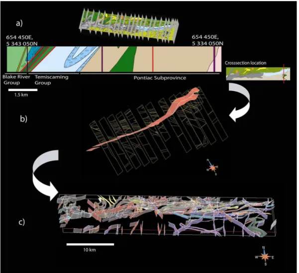
Figure 2-3: Illustration of the advantages of having a 3D representation versus a 2D map. A 3D approach allows a better visualizing capacity of spatial relationships as shown by the connection between the intersection of faults 1 and 2 and the mineralized occurrence. A 3D representation also avoids distortion due to projections to surface and data stacking (as seen with the drill hole
representation on both images) and offers the possibility of calculating true distances between geological features. ... 55 Figure 2-4: a. Location and example of the interpreted cross sections; b. Surface
representation of the CLLF being constructed by joining the dip interpretations in each cross section; c. Surface model of the study area (without the
Proterozoic sedimentary cover and Archean units underneath). ... 57 Figure 2-5: Data used to model the 3D geometry of the Archean-Proterozoic
unconformity consisted of bedding measurements at the borders of the Cobalt Group (map view) (a) and drill holes within the Cobalt sediments (b). The intersections of the Archean-Proterozoic unconformity are shown in red whereas drill holes that did not intersect Archean basement are shown in grey (oblique view). c. Model of the thickness of the Proterozoic cover. ... 59 Figure 2-6: a. Geological model of the units lying underneath the Cobalt Group. b.
Calculated distance to drill hole data and observed contacts near the edge of the Proterozoic sedimentary cover, the two main constraints for the interpretation the underlying 3D geological map. The distance to these control points can be considered as an indication of the degree of uncertainty in the model... 61
Figure 2-7: a. Map of the residual gravimetric anomaly. b. Section of the
unconstrained inversion of the gravimetric data showing the general attitude of the CLLF under the Cobalt Group sediments... 62 Figure 2-8: Longitudinal section of the unconstrained inversion of the magnetic data
which allows interpretation of the dip of the Milky Creek, Beauchastel, Horne Creek and Davidson Creek Faults at depth... 64 Figure 2-9: a. Location of all gold assays and of major deposits: Francoeur 1, 2 and
3 (F1, F2, F3); Arntfield 1, 2, and 3 (A1, A2, A3); Fortune Lake (LF); Augmitto (Au); Bazooka (BA), Astoria (AS); Granada (GR); Stadacona (ST); Forbex (FO); McWatters (MC); New Rouyn-Merger (NR) and O’Neail-Thompson (OT). b. Upscaled assays with a grid of 250 x 250 x 250 m showing mineralized (> 950 ppb) and unmineralized occurrences... 66 Figure 2-10: Calculated distance of mineralized occurrences to E-W faults (a) and to
fault intersections (b). Histograms show the cumulative frequency of mineralized occurrences versus to the distance to both fault groups, and
calculated weights with confidence intervals. ... 74 Figure 2-11: Calculated distance to intrusions with accompanying histogram showing
the cumulative frequency of mineralized occurrences versus to the distance to the nearest intrusion, with calculated weights and confidence intervals ... 75 Figure 2-12: a. Mineral potential map for orogenic gold mineralization under the
Proterozoic sedimentary cover. Index values vary from -0.3 to 1. b. Location in 3D of zones with highest index value painted accordingly to their depth with respect to the unconformity contact and CLLF. ... 78
Figure 3-1: Simplified geological map along the Cadillac-Larder Lake Fault Zone (CLLFZ) showing the location of past and present gold mines. ... 98 Figure 3-2: Geological map of the study area ( modified from Rabeau et al., 2009 and
Legault and Rabeau, 2007) ... 100 Figure 3-3: Timing of rock formations, tectonic events and gold mineralizations
within the study area... 103 Figure 3-4: (A) Surfaces defining the structural boundaries within the geomechanical
model. (B) Surfaces defining the lithological contacts shown with the Wasa and Cadillac Larder Lake Faults... 109 Figure3-5: Solid Model divided in 3 regions by the 2 structural discontinuities ... 111 Figure 3-6: Boundary conditions applied to model the strain along the Wasa Fault
and the CLLF simultaneously... 114 Figure 3-7: A) Boundary conditions given to model the strain in 3D for the
compressive phase, B) : Boundary conditions given to model the strain in 3D for the transpressive phase... 116 Figure 3-8: Results from the strain modelling. Each deformation phases are
presented with dilation painted on the deformed solid model and by a point set representing zones where the initial volume of the surrounding tetras increased of more than 1%. A) Strain modelling for the combination of two
displacements, compression on the Wasa Fault and dextral slip on the CLLF. These movements represent the transition between the compressive and transpressive regimes (D2 and D3). B) Compression on both structural
Figure 3-9: Correspondence between the important orogenic gold mineralizations located within the study area (red sphere) and the dilatant sites o each
deformation phase modeled. ... 122 Figure 3-10: Distribution of IPAF (Piché and Jébrak, 2007) values of more than 50
(black diamonds) with zones of more than 1% volume change when performing strain modeling of the transition phase (cubes). ... 123
Liste des tableaux
Table 1-1: Deposits located in a 1000m buffer zone of the Cadillac-Larder Lake Fault Zone that where used in the study (ESTN and NORD given in UTM Nad 83) ... 25 Table 2-1: Data used to construct the geological model... 56 Table 2-2: Spatial associations with mineralization (* = favorable features)... 71 Table 2-3: Combination index for each geological feature used for mineral potential
mapping ... 77 Table 3-1: Comparison between geomechanical modelling approaches used to
identify zones of enhanced permeability in the study of epigenetic
mineralizations... 104 Table 3-2: Mechanical properties of the different rock types present in the model. ρ
= density, E = Young modulus, σ = Poisson coefficient, λ = Lamé’s constant, µ = Shear modulus, K = Bulk modulus... 112 Table 3-3: Orientation of the displacement vector for each fault considered in the
study. 1 Daigneault (1994), 2 Daigneault et al. (2002), 3 Legault and Rabeau (2009)... 113
Contribution des auteurs
Cette thèse est présentée sous forme d’articles scientifiques. J’ai effectué la plus grande partie des travaux en tant que premier auteur de ces articles. Je me dois par contre de souligner la participation des autres auteurs qui ont apporté une contribution dans l’interprétation des données ainsi que dans la relecture critique du texte de cette thèse. Les noms des gens ayant contribués sont énumérés au début de chaque article en tant que co-auteurs. Cette section vise à mettre en valeur la contribution spécifique de chacun des participants au travail accompli.
Dans la première partie de la thèse traitant de la distribution des gisements le long de la Faille Cadillac-Larder Lake, Jean Jacques Royer (ENSG-CRPG) a contribué à l’analyse spatiale des données et m’a aidé dans la réflexion permettant de dégager la loi mathématique expliquant la distribution spatiale des gisements. Alain Cheilletz (ENSG-CRPG) et Michel Jébrak (UQÀM) ont contribué en effectuant des lectures critiques sur le manuscrit.
Le second chapitre est le fruit du traitement d’une importante base de données et comprend la participation d’un bon nombre de personne. Marc Legault, à l’époque à l’emploi du Ministère des Ressources naturelles et de la Faune, a contribué en révisant la cartographie de surface ainsi que la caractérisation des minéralisations aurifères dans le cadre de ses fonctions. Li Zhen Cheng (UQAT) a contribué à l’interprétation géophysique en profondeur et a effectué les inversions
gravimétriques et magnétiques. Jean-Jacques Royer, Michel Jébrak et Alain Cheilletz ont effectué une lecture critique du manuscrit.
Finalement, le dernier chapitre de cette thèse qui renferme des travaux basés sur la modélisation géomécanique a été fait avec la collaboration de Marc-Olivier Titeux (ENSG-CRPG) qui m’a conseillé lors des étapes de modélisation et de paramétrisation. Michel Jébrak, Jean-Jacques Royer, Guillaume Caumon (ENSG-CRPG) et Alain Cheilletz ont effectué des lectures critiques du manuscrit.
Introduction
Les gisements d’or de type orogéniques comptent pour plus de 30% de la production mondiale en Au (Frimmel, 2007). Ces gisements épigénétiques sont retrouvés partout sur la planète dans des lithologies très variées tant en âge qu’en composition (Goldfarb et al. 2001). Une association particulière est par contre observée avec les ceintures de roches vertes archéennes où la majorité de ces gisements sont retrouvés. Au sein des ceintures de roches vertes archéennes, les gisements de type orogéniques présentent une association spatiale importante avec les failles majeures (Goldfarb et al., 2005 ; Goldfarb et al., 2001 ; Groves et al., 1998 ; Groves et al., 2003 ; Weinberg et al., 2004). On observe d’ailleurs plusieurs dépôts d’or de type orogénique qui s’alignent le long de ces failles ainsi que de leur extension verticale dans les terrains archéens à petite échelle. Ces failles majeures agissent souvent comme zones de sutures entre des terrains d’affinité différente. Ces structures qui sont souvent d’importance crustale sont dites de premier ordre et possèdent une expression en surface de plusieurs dizaines de kilomètres et une épaisseur pouvant atteindre quelques centaines de mètres (Goldfarb et al., 2005). Elles sont généralement subverticales, parallèles à subparallèles à la stratigraphie locale et deviennent listriques à très grandes profondeurs (Wyman and Kerrich, 1988). Elles représentent, pour la plus part, l’expression de plusieurs structures segmentées possédant une évolution complexe et multiphasée sur plusieurs millions d’années (Goldfarb et al., 2001). Ces failles comportent un intérêt économique majeur puisqu’il est reconnu qu’elles agissent comme conduits principaux pour la circulation de fluides
hydrothermaux possédant une source profonde (Beaudoin et al., 2006 ; Goldfarb et al., 2001 ; Goldfarb et al., 1991 ; Groves et al., 2000 ; Groves et al., 2003 ; Kerrich et al., 2000). Ces structures majeures agissent, en fait, comme système de type « pompe et valve » auprès des fluides minéralisateurs aurifères (Cox et al., 2001 ; Sibson et al., 1988).
Les failles de premier ordre dans les ceintures de roches vertes archéennes s’intègrent dans un réseau de failles et de fractures important comprenant aussi des failles de moins grande portée de deuxième et de troisième ordre. Ces dernières sont décrites comme étant respectivement parallèles et obliques au grain structural (Robert and Poulsen, 2001). Malgré leur rôle essentiel dans le transport des fluides aurifères, les failles majeures (de premier ordre) ne sont pas hôtes de la majorité des dépôts connus d’or de type orogénique. En fait, il est supposé que les failles de premier ordre amènent les fluides de source profonde jusqu’aux failles de 2e et 3e ordre de la croûte supérieur où les métaux précipitent (Eisenlohr et al., 1989; Kerrich and Feng, 1992). Les structures de dilatation servant à la précipitation des substances économiques à partir des fluides hydrothermaux sont variées et comprennent aussi les charnières de plis anticlinaux, les fractures associées aux contrastes de compétence entre les unités et les intersections de failles.
Malgré un contrôle d’ordre structural très important et l’évidence du rôle prédominant des failles de premier ordre, la distribution des dépôts d’or de type orogénique est en fait très irrégulière. L’activité des zones de déformation en tant que conduits pour les fluides minéralisateurs est hétérogène dans le temps et dans
l’espace. On retrouve, en effet, des zones très riches en minéralisations et des secteurs qui en sont exempts. Typiquement, à une échelle régionale, les gisements aurifères très riches se concentrent en amas, les camps miniers, d’environ 100 à 1000 km2 (Hodgson, 1993). Au sein de ces camps miniers, la distribution est dépendante de certains facteurs précis favorisant la circulation et la précipitation des métaux. Ces facteurs peuvent être très différents d’un terrain à l’autre malgré certains principes structuraux et géométriques qui restent similaires (Groves et al., 2000). Cette irrégularité dans la distribution des minéralisations est principalement due aux variations locales de perméabilité permettant la circulation de fluides et les dépôts de minéralisations.
Ce travail vise à effectuer l’étude de la distribution des gisements d’or de type orogénique le long de grands couloirs de déformation archéens par une approche numérique. En premier lieu, ce travail présente une étude da la distribution spatiale à grande échelle des gisements aurifères connus le long d’un couloir de déformation archéen majeur. Cette approche vise à établir s’il existe une relation mathématique caractérisant la distribution spatiale des gisements d’or orogénique le long de grand couloir de déformation archéen ou si la localisation d’un gisement est indépendante de la position spatiale des autres. Ce type d’approche, basée sur une distribution géographique systématique, permet d’apporter des éléments de réponse en ce qui concerne le mode de formation des gisements aurifères de type orogénique et peut être exploité comme un outil d’exploration utile à l’échelle régionale. La deuxième partie de cette thèse aborde l’évaluation de potentiel par le biais de la modélisation régionale en 3D d’un segment d’une faille archéenne de premier ordre identifiée
comme possédant un fort potentiel pour la présence de gisements non découverts à cause d’une couverture sédimentaire protérozoïque qui complique l’exploration. Ce chapitre vise à dresser le lien entre la présence de minéralisation le long de zones de suture archéennes ainsi que de leurs failles subsidiaires et la présence de certains éléments géologiques précis. L’association spatiale entre ces facteurs et les minéralisations aurifères a par la suite été pondérée et utilisée dans la génération de cartes de potentiel minéral en 3D spécifique à l’emplacement étudié. Finalement, un segment choisi d’un couloir de déformation archéen sera utilisé afin d’effectuer une modélisation géomécanique. Ce chapitre se base sur la notion que les pressions tectoniques et lithostatiques infligées à un volume rocheux entraînent des migrations de fluides des zones à hautes pressions vers les zones à basses pressions. Considérant que l’or s’est mis en place dans les ceintures de roches vertes suite à la majorité de la déformation tectonique, il est raisonnable de croire qu’en déformant une représentation 3D de la géologie présente aujourd’hui en utilisant les indicateurs cinématiques observables sur le terrain, il sera possible de développer un outil permettant la prévision de l’emplacement des zones de circulation hydrothermale lors de la mise en place de l’or.
Époque de mise en place de l’or de type orogénique
Cette thèse utilise une approche numérique afin d’effectuer l’étude de la distribution des gisements aurifères de type orogénique le long de grands couloirs de déformation archéens. Ce type d’étude implique une très bonne connaissance de la géologie de la
ceinture de roches vertes hôte. Cette géologie est étudiée en fonction de la géométrie des entités observables présentement. L’utilisation d’observations et de données provenant de la ceinture de roche verte afin d’interpréter des modèles géologiques 2D ou 3D et de les mettre en relation avec les minéralisations aurifères implique que la géométrie observable aujourd’hui doit être similaire à celle présente lors de la mise en place. L’époque de mise en place de l’or de type orogénique par rapport à l’évolution tectonique de la ceinture est donc un élément crucial.
Cette thèse se concentre sur la distribution des gisements d’or orogénique au sein de la Sous-province archéenne de L’Abitibi. L’apparition tardive des minéralisations aurifères de type orogénique dans l’évolution tectonique des ceintures de roches vertes archéennes comme celle de l’Abitibi a été établie par plusieurs auteurs en se fiant principalement à des observations de terrain et à l’âge relatif des minéralisations par rapport aux unités datées les recoupant (Groves et al, 2000, Goldfarb et al., 2005, Dubé et Gosselin, 2007). Il a été statué que l’événement minéralisateur principal se serait produit à la fin de l’événement compressif Nord-Sud qui est responsable de l’orientation est-ouest des unités de la ceinture (Robert et al., 2005). Ceci implique donc une mise en place tardive par rapport à la déformation. Même si certaines minéralisations semblent plus précoces (Couture et al. 1994) ou montrent des évidences de déformation ainsi que de remobilisation importante, cette étude fait la supposition que l’événement hydrothermal principal ayant engendrée la formation de la très grande majorité des gisements orogénique s’est produit tardivement dans l’évolution tectonique.
Ayant établi que la géométrie structurale observable est très similaire à celle présente lors de la circulation des fluides minéralisateurs et la mise en place des gisements d’or de type orogénique (Groves et al., 2000). Il est donc scientifiquement possible d’utiliser des cartes géologiques, des sections ou des modèles géologiques 3D représentant la géométrie actuelle afin d’effectuer la simulation des conditions physiques présentes lors de la mise en place des minéralisations (Groves et al., 2000 ; Weinberg et al., 2004).
Références
Beaudoin, G., Therrien, R., and Savard, C., 2006, 3D numerical modeling of fluid flow in the Val-d'Or orogenic gold district: major crustal shear zones drain fluids from overpressured vein fields: Mineralum Deposita, v. 41, p. 82-98.
Cox, S. F., Knackstedt, M. A., and Braun, J., 2001, Principles of structural control on permeability and fluid flow in hydrothermal systems., in Richards, J. P., and Tosdal, R. M., eds., Structural controls on ore genesis, volume 14. Reviews in Economic geology., Society of Economic Geologists.
Couture, J.-F., Pilote, P., Machado, N., Desrochers, J.-P. 1994, Timing of gold mineralization in the Val-d'Or District, southern Abitibi Belt; evidence for two distinct mineralizing events, Economic Geology; v. 89; no. 7; p. 1542-1551
Dubé, B. et Gosselin, P., 2007, Greenstone-hosted quartz-carbonate vein deposits, in Goodfellow, W.D., ed., Mineral Deposits of Canada: A Synthesis of Major Deposit-Types, District Metallogeny, the Evolution of Geological Provinces, and Exploration Methods: Geological Association of Canada, Mineral Deposits Division, Special Publication No. 5, p. 49-73.
Eisenlohr, B. N., Groves, D. I., and Partington, G. A., 1989, Crustal-scale shear zones and their significance to Archaean gold mineralization in Western Australia: Mineralium Deposita, v. 24, p. 1-8.
Frimmel, 2007, Earth's continental crustal gold endowment, Earth and Planetary Science Letters 267, 1-2, 1, p. 45-55
Goldfarb, R. J., Baker, T., Dubé, B., Groves, D. I., Hart, C. R. J., and Gosselin, P., 2005, Distribution, Character, and Genesis of Gold Deposits in Metamorphic Terranes, p. 407-450.
Goldfarb, R. J., Groves, D. I., and Gardoll, S., 2001, Orogenic gold and geological time: a global synthesis: Ore Geology Reviews, v. 18, p. 1-75.
Goldfarb, R. J., Snee, L. W., Miller, L. D., and Newberry, R. J., 1991, Rapid dewatering of the crust deduced from ages of mesothermal gold deposits: Nature, v. 354, p. 296-298.
Groves, D. I., Goldfarb, R. J., Gebre-Mariam, M., Hageman, S. G., and Robert, F., 1998, Orogenic gold deposits: A proposed classification in the context of the crustal distribution and relationship to other deposit types: Ore Geology Reviews, v. 13, p. 7-27.
Groves, D. I., Goldfarb, R. J., Knox-Robinson, C. M., Ojala, J., Gardoll, S., Yun, G. Y., and Holyland, P., 2000, Late-kinematic timing of orogenic gold deposits and significance for computer-based exploration techniques with emphasis on the Yilgarn Block, Western Australia: Ore Geology Reviews, v. 17, p. 1-38.
Groves, D. I., Goldfarb, R. J., Robert, F., Hart, C. R. J., and, 2003, Gold deposits in metamorphic belts: overview of current understanding, outstanding problems, future reaserch, and exploration significance.: Economic Geology, v. 98, p. 1-29.
Hodgson, C. J., 1993, Mesothermal Lode-gold Deposits, in Kirkham, R. V., Sinclair, W. D., Thorpe, R. I., and Duke, J. M., eds., Mineral Deposit Modeling, Special Paper 40, Geological Association of Canada, p. 635-678.
Kerrich, R., and Feng, R., 1992, Archean geodynamics and the Abitibi-Pontiac collision: implications for advection of fluids at transpressive collisional boundaries and the origin of giant quartz vein systems: Earth-Sci. Rev., v. 32, p. 33-60.
Kerrich, R., Goldfarb, R. J., Groves, D. I., and Garwin, S., 2000, The Geodynamics of World-Class Gold Deposits: Characteristics, Space-Time Distribution, and
Origins., in Hageman, S. G., and Brown, P. E., eds., Gold in 2000, 13, Reviews in Economic geology, p. 500-551.
Sibson, R. H., Robert, F., and Poulsen, K. H., 1988, High-angle reverse faults, fluid-pressure cycling, and mesothermal gold-quartz deposits: Geology, v. 16, p. 551-555.
Weinberg, R. F., Hodkiewicz, P. F., and Groves, D. I., 2004, What controls gold distribution in Archean terranes? Geology, v. 32, p. 545-548.
Wyman, D., and Kerrich, R., 1988, Alkaline Magmatism, Major Structures, and Gold Deposits: Implications for Greenstone Belt Gold Metallogeny: Economic Geology, v. 83, p. 454-461.
Chapitre 1: Spatial Distribution of Orogenic Gold
Deposits along Major Archean Faults
1.1 Introduction générale
Ce chapitre est consacré à l’étude de la distribution statistique des minéralisations aurifères de type orogénique le long de grands corridors de déformation archéens. L’objectif principal de ce travail est de déterminer s’il existe une relation mathématique décrivant la distribution spatiale des gisements d’or de type orogénique le long de couloirs de déformation archéens majeurs ou si la position de chacun des gisements est indépendante de celle des autres.
Les travaux présentés se concentrent sur les failles Cadillac Larder Lake et Porcupine-Destor dans la ceinture de roches vertes de l’Abitibi dans la Province du Supérieur au Canada. Ces failles représentent des structures majeures visibles sur plusieurs dizaines de kilomètres et ayant contrôlé l’évolution hydrothermale d’une importante portion de croûte à l’Archéen. De plus, une importante base de données est déjà existante le long de ces couloirs de déformation qui permet ce type d’étude. Afin de prendre en compte la zone de dommage des failles, une zone tampon de 1 km a été créée le long des deux failles et tous les gisements inclus dans cette zone ont été considérés dans l’étude. Un total de soixante-douze et vingt gisements connus le long des failles Cadillac-Larder Lake et Porcupine-Destor ont respectivement été
utilisés afin de vérifier si leur distribution spatiale pouvait être considérée comme aléatoire ou si elle respectait une logique cohérente.
Une distribution de type log-uniforme a été trouvée entre la fréquence cumulative d’occurrence et l’inter-distance curvilinéaire entre les gisements.de type orogénique pour des inter-distances variant entre 315 et 5600 m le long de la Faille Cadillac-Larder Lake. Puisque les gisements sont moins nombreux le long de la Faille Porcupine-Destor, l’étude de cette dernière a servi à valider les résultats obtenus pour la Faille Cadillac-Larder Lake.
Les résultats le long de ces failles ont été interprétés comme suggérant une influence structurale très importante sur la mise en place des minéralisations aurifères de type orogénique. En fait, les auteurs suggèrent que les emplacements minéralisés pourraient représenter des zones de relâchement de pression hydrostatique et que la distribution représenterait des ruptures structurales le long de la faille Cadillac-Larder Lake. Ces ruptures dues à des surpressions de fluides hydrothermaux créeraient des zones de perméabilité structurale importante et permettraient la circulation des fluides et le dépôt des minéralisations par relâchement de pression. Les résultats suggèrent que les zones d’influence de ces relâchements décroissent de façon logarithmique.
Finalement, une probabilité a été dérivée de la loi log-uniforme afin de générer une carte de potentiel en minéralisations aurifères de type orogénique régionale. Cette carte est basée sur la localisation des dépôts connus et permet une approche
prédictive régionale qui peut s’avérer utile puisqu’elle permet de travailler avec une grande variété d’environnements géologiques et de cibler des territoires à plus fort potentiel en minéralisations sur une grande étendue.
Spatial Distribution of Orogenic Gold
Deposits along Major Archean Faults
Olivier Rabeau
Université du Québec en Abitibi-Témiscamingue, Unité de recherche et de services en technologie minérale, 445 boul. de l'Université, Rouyn-Noranda, QC,
Canada, J9X 5E4, Tel: (819) 354 4514 #248, Fax : (819) 354 4508 -
Jean-Jacques Royer
CRPG, Centre de Recherche Pétrographique et Géochimique, Nancy Université, BP 20, 54501 Vandœuvre-lès-Nancy Cedex, France - [email protected]
Michel Jébrak
UQAM, Université du Québec à Montréal, Département de Sciences de la Terre et de l’Atmosphère, 201, avenue du Président-Kennedy, PK-615, Montréal, QC, Canada,
H2X 3Y7 - [email protected]
Alain Cheilletz
CRPG, Centre de Recherche Pétrographique et Géochimique, Nancy Université, BP 20, 54501 Vandœuvre-lès-Nancy Cedex, France - [email protected]
Keywords: orogenic gold, spatial distribution, Cadillac Larder Lake Fault, hydrothermal flow, Archean
1.2 Abstract
The Cadillac-Larder Lake Fault zone located in the Abitibi Greenstone Belt in Canada was selected to determine if a mathematical relation can characterize the spatial distribution of orogenic gold deposits along a crustal scale fault zone within an Archean greenstone belt or if the localization of a deposit is independent of the position of each other. The Cadillac-Larder Lake Fault is a typical example of a large crustal scale fault zone which controlled the hydrothermal evolution of a large part of an important greenstone Belt. The extensive database of gold deposits compiled along this major structure makes it suitable for a study on the spatial distribution of ore deposits.
A buffer zone of 1 km was calculated around the fault trace and all deposits located within this zone were projected on the fault trace. A total of seventy two gold deposits were used to determine the spatial relationship. A uniform law was fitted between the frequency and the curvilinear inter-distance between successive orogenic gold occurrences along the CLLF for distances ranging from 315 to 5600 m. These results suggest that the spatial distribution of gold deposits may be attributed to structural failure and that the influence of lithological variation at a regional scale has a very low impact on the localization of gold mineralization along a crustal scale fault zone. The structural failure allowing fluid circulation during compression may be induced by hydrostatic overpressure along a major Archean within the fault zone. The logarithmic distribution of inter-distances between
deposits may explain that pressure release decreases following logarithmic law. Finally, probability was derived from the log uniform distribution to create a regional probability map along the Cadillac Larder Lake Fault Zone that is based on the location of known deposits.
1.3 Introduction
At mining camp scale, exploration geologists can rely on certain recurring features to evaluate the emplacement of orogenic gold mineralizations within Archean Greenstone belts. Many works on mineral potential mapping (Groves et al., 2000) or concerning controls on hydrothermal fluid flow (Cox et al, 2001; Sibson, 2001; Micklethwaite and Cox, 2004) have refined these exploration guidelines. The efficiency of predictive approaches relying on geological features is highly dependent on the location and dimension of the area being prospected. Similar approaches applied to a regional present a higher degree of difficulty because of the variety of geological environments.
Major crustal scale fractures such as the Boulder-LeFroy in the Yilgarn Craton or the Cadillac Larder Lake and the Destor-Porcupine faults in the Superior Craton represent, in a regional perspective, the main metallotect for orogenic gold deposits in Archean greenstone belts. These structures spatially control the distribution of gold deposits acting as conduits that channel deep seated hydrothermal fluids (Goldfarb et al., 2001; Groves et al., 2003; Kerrich et al et al., 2000). Even tough,
the association between these important structures and their vertical extension with orogenic gold mineralizations is clear, the distribution of deposits along the major structures still remains heterogonous and presents an apparently irregular pattern. Only a few studies have addressed the problem of regional distribution of orogenic gold deposits along major fault zones (Groves et al., 1998; Weinberg et al. 2004) within prolific Archean Greenstone Belts.
Figure 1-1: Simplified geology surrounding the Cadillac-Larder Lake Fault Zone (red) with localization of gold mines (yellow dots) and copper and zinc mines (red squares)
The main objective of this work is to determine if a mathematical relation can characterize the spatial distribution of orogenic gold deposits along a crustal scale fault zones or if the localization of a deposit is independent of the position others. The study will focus on the main fault zone in the Abitibi Subprovince in terms of gold production, the Cadillac–Larder Lake Fault (CLLF) (fig, 1-1). This structure is
a typical example of a large crustal scale fault within an Archean greenstone Belt and the extensive database of gold deposits compiled along this major structure makes it suitable for a study on the spatial distribution of ore deposits.
1.4 Geological setting
The Archean Abitibi and Pontiac Subprovinces (Figure 1-1) are located in the southern part of the Superior Craton. The Abitibi Subprovince is renowned as one of the richest gold and base metal producing region of the world. This plutonic and supracrustal belt is mainly composed of volcanic rocks ranging from komatiites to rhyolite, sediments intruded by many plutonic bodies with ages varying in a range of 2670 to 2759 Ma (Goutier and Melançon, 2007 and references therein). The Abitibi Subprovince has been defined as a collage of two arcs, the older Northern and younger Southern volcanic zones (Chown et al., 1992). However, recent studies indicate that the Abitibi Subprovince could be much more complex than a simple collage of younger volcanic episodes onto old ones (Thurston, 2008). In many cases, geochronological data show a dismembering of older volcanic episodes with rifting during extrusion of younger volcanics (Goutier et al., 2008). Two main faults cross cut the Abitibi Green stone belt, Cadillac Larder Lake Fault (CLLF) and the Porcupine Destor Fault (PDF). The Pontiac Subprovince is (2,685 Ma to 2,672 Ma; Davis, 2002) located South of the Abitibi Subprovince is mainly composed of highly
folded and deformed turbiditic sediments with rare horizons of mafic to ultramafic volcanics. .
In the Province of Quebec, the limit between these two Subprovinces is marked by one of the most important crustal scale fault zones in the area, the Cadillac Larder Lake Fault (Fig. 1-1). This major structure has been interpreted as a suture zone separating these terrains of different affinity (Daigneault & Mueller, 2004, Kerrich & Feng, 1992). The CLLF has a lateral extent of more than 200 km and can be identified from the city of Matachewan in Ontario to the city of Val-d’Or in Quebec. More than 2000 Mt of gold have been extracted from its vicinity from many world class mining camps ( >100 Mt) such as Val-d’Or, Malartic, Cadillac, Larder Lake and Kirkland Lake (Poulsen et al., 2000)
Recent studies (Benn and Plesher 2005) based on analogue modeling, gravity models, seismic data and recent field work have interpreted the western segment of the CLLF and Porcupine Destor Fault located 200 km North as shallowly rooted fold-related structures. A consensus has been established on the fact that the eastern part of the CLLF actually represents a transcrustal structure marking the Boundary between the Pontiac Abitibi and the Pontiac Subprovinces (Dimroth et al., 1982) which lie respectively north and south of the CLLF.
1.5 Distribution of orogenic gold deposits along the CLLF
Spatial distribution of mineral deposits has been of great interest for the exploration and the research community even considering that mine or deposit distribution can only give an evaluation of the true metallic distribution of an area considering undiscovered deposits and economic factors. A systematic geographical distribution
of mineralizations can be exploited as a valuable regional exploration tool and analogues to evaluate natural resource potentiality in under explored regions presenting similar geological context (McCammon, 1993). The mathematical function that determines the spatial distribution of orogenic gold mineralization can be used to determine fault segment which are the most favorable for undiscovered deposits along important Archean structures. Furthermore, the distribution of mineral deposits can provide insights on the formation of gold deposits.
A fractal approach was considered to explain the spatial distribution of precious metals within the Sierra Nevada (Carlson, 1991) and gold deposits in the Zimbabwe craton (Blenkinsop and Sanderson, 1999). The distribution of Archean orogenic gold deposits in the vicinity of crustal scale fault zone has also been tested along the Boulder-Lefroy Fault zone in Australia by Weinberg et al (2004) which noted a link with the presence of a gold mine and geological complexity. The approach proposed in this study is focussed on the distance separating each deposit from its neighbors and the possible relation with the distribution of mineralizing fluids pathways in structural dilation sites
1.6 Available Data and Methodology
The spatial analysis of the distribution orogenic gold deposits along the CLLF was undertaken using information contained in the public database of the Ministry of Natural Ressources and Fauna of Quebec. The study focuses on the segment where the CLLF marks the boundary between the Abitibi and Pontiac. The length of this segment of the CLLF represents about 160 km and almost 80% of its total length.
The CLLF is often represented as a line on the 2D map even though the associated damage zone of this major structure represents a much larger area, corresponding to many hundred meters. To account for the thickness of the deformation zone and the multiple splays directly associated to the CLLF, a one kilometer buffer zone was established around the map trace of the CLLF in the sector of interest. All deposits located within this zone were used to conduct the spatial analysis. Mineralized occurrences defined by a single sample or a drill hole interception were not taken into account. The final deposit database is presented in table 1.
The deposit database was filtered to conduct the analysis only on deposits belonging to the orogenic gold type, and avoid incorporating other mineralization types with distinct characteristics, source, timing, and formation mechanism. Other types of gold mineralizations encountered in the study area are mainly volcanic massive sulfides or porphyry type deposits. Individual studies of deposits were used to determine the type of mineralization (Couture, 1996, Legault & Rabeau, 2006; Pilote et al., 2000; Lafrance et al., 2003; , Poulsen et al., 2000; Robert et al. 2005; Dubé and
Gosselin, 2007). Certain known characteristics of orogenic gold deposits were also used to discriminate orogenic gold deposits from other types of gold mineralization. The metal content was the main discriminating factor on the basis that f the mineralizing fluids involved in the formation of orogenic gold have very low salinity deposits implying low base metal content (Groves et al., 2003).
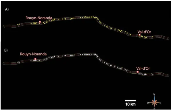
Figure 1-2: A) Distribution of orogenic gold deposits used in the study (yellow dots) and Cadillac-Larder-Lake fault zone (red line) with 1000 m buffer zone (yellow line). B) Projected known gold deposits
Figure 1-3: Distance of deposits to the Cadillac-Larder-Lake Fault
A total of 72 orogenic gold deposits identified along the investigated distance on the CLLF were used to conduct the spatial analysis. At regional scale all of these deposits can be represented as points on a 2D map. A map presenting the location of these deposits is presented in figure 1-2a. Most gold deposits are located less than 440 m from the CLLF with a mean distance of 290 m (Fig. 1-3). These orogenic gold deposits were then projected on the line representing the CLLF (figure 1-2B) and the curvilinear distance between each of the deposits was calculated following the fault trace (table 1). The methodology does not use the Euclidian distance, but the curvilinear distance calculated along the fault. A mean distance of 1950m was calculated between deposits. The cumulative frequency distribution Fd was
calculated and plotted against the log of the measured curvilinear inter distance d between successive Au deposits along the CLLF (figure 1-4). A theoretical
distribution model defined for curvilinear distances d ranging from 315 m to 5615 m, was fitted using a mean squares method on the observed frequency distribution according to the following linear model (R2 = 0.993, N = 65). This theoretical distribution model
F
D[d]
is based on a Log-uniform distribution. The details of thistype of distribution are presented in annexe 1. The following equation defines the theoretical distribution model:
(
)
026 . 0 008 . 0 10 D966
.
1
b
793
.
0
a
]
m
5615
,
m
315
[
d
b
)
d
(
Log
a
d
D
P
)
d
(
F
± ±=
=
∈
−
=
≤
=
(eq. 1) MineralizedBody Deposit Type
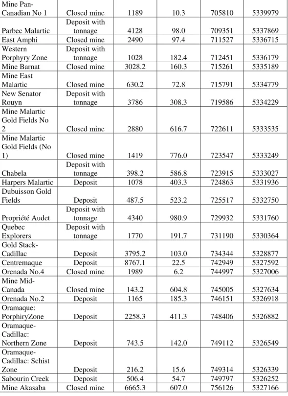
Curvilinea r Distance (m) Distance to CLLF (m) ESTN NORD
Lac Sanies Zone
Est Deposit 0 1001 625066 5338534
Lac Fortune Deposit with tonnage 1708 939.3 626711 5338979 Rivière Adeline Deposit 11135 146.6 637976 5339618
Bazooka Deposit with tonnage 2738 206.7 640711 5339829 Mc Donough Deposit 66.5 679.0 640761 5340304
Augmitto Deposit with tonnage 702 76.0 641487 5339710 Durbar
Deposit with
tonnage 423.4 359.5 641906 5339999 Cinderella Deposit 546.1 62.0 642461 5339584 Goldbar Deposit 448 517.0 642911 5340169 Astoria Closed mine 3508.9 34.5 645961 5339735 Lac Bouzan Deposit 3925.4 130.9 649811 5340330
Dransfield zone Deposit 950.5 796.9 650931 5339620
Pepmont Deposit 2146 652.8 653191 5340525 Dovercliff
Deposit with
tonnage 889.8 321.2 653366 5341735 MineMcWatters Closed mine 2205.1 245.0 655531 5342080 Mine New
Mine
O'Neill-Thompson Closed mine 1200 130.9 659011 5342930 East O'Neill
Deposit with
tonnage 521.1 204.9 659521 5342795 Davidson Fault Deposit 1154 444.4 660436 5343820
Davidson Creek Deposit 377.9 178.0 660911 5343280 Mine Heva Closed mine 4014.6 162.7 664901 5343535 Mine Hosco Closed mine 3467 133.4 668361 5343880
Bouzan-Or Deposit 2698 16.0 671030 5344271 Maracambeau Deposit 548.3 449.1 671611 5343845 Paquin Deposit with tonnage 4633.9 854.4 676261 5343730 Calder Bousquet ( 1) Deposit 840.7 250.9 677061 5344380 Calder Bousquet (2 and5) Deposit 1295 148.7 678356 5344595 Calder Bousquet ( 4) Deposit with tonnage 547.3 40.8 678886 5344770 Cavanagh Deposit 1761 252.0 680661 5344780 Lac Norman Deposit with tonnage 5459 106.0 686071 5345140 Brown-Bousquet Deposit 1988 91.6 688056 5345132 Bouscadillac Deposit with tonnage 2139 55.6 690196 5345284 Brown-Cadillac Deposit 344.8 649.9 690486 5346010 Mine Thompson
Cadillac Closed mine 1586 62.7 692111 5345539 Mine O'Brien Closed mine 694.6 52.1 692801 5345579
Zone 36 Est Deposit with tonnage 1376 58.6 694189 5345538 Mine Kewagama Closed mine 690.7 46.0 694870 5345674
Mine Central
Cadillac Closed mine 1791 27.0 696656 5345756 Mine Gallant Closed mine 352.8 28.9 697018 5345729
Mine Pandora No 3 Closed mine 1364 24.5 698361 5345899 Mine Pandora No 4 Closed mine 1222 683.6 699311 5345075 Pandora No 1 Deposit 670.5 402.3 700011 5345129 Mine Pandora No 2 Closed mine 590.9 68.5 700761 5345334 Tonawanda Deposit 925.9 281.0 701715 5345144 MineLapaCadill ac Closed mine 741.3 719.7 702773 5344429 Maritime Cadillac Deposit 986.9 462.8 702991 5343574 Mine
Pan-Canadian-No Closed mine 3162.1 184.5 704666 5341186 MinePaCanadia
Mine
Pan-Canadian No 1 Closed mine 1189 10.3 705810 5339979 Parbec Malartic
Deposit with
tonnage 4128 98.0 709351 5337869 East Amphi Closed mine 2490 97.4 711527 5336715
Western Porphyry Zone
Deposit with
tonnage 1028 182.4 712451 5336179 Mine Barnat Closed mine 3028.2 160.3 715261 5335189
Mine East
Malartic Closed mine 630.2 72.8 715791 5334779 New Senator Rouyn Deposit with tonnage 3786 308.3 719586 5334229 Mine Malartic Gold Fields No 2 Closed mine 2880 616.7 722611 5333535 Mine Malartic Gold Fields (No
1) Closed mine 1419 776.0 723547 5333249 Chabela
Deposit with
tonnage 398.2 586.8 723915 5333027 Harpers Malartic Deposit 1078 403.3 724863 5331936
Dubuisson Gold Fields Deposit 487.5 523.2 725517 5332750 Propriété Audet Deposit with tonnage 4340 980.9 729932 5331760 Quebec Explorers Deposit with tonnage 1770 191.7 731190 5330364 Gold Stack-Cadillac Deposit 3795.2 103.0 734344 5328877 Centremaque Deposit 8767.1 22.5 742949 5327592 Orenada No.4 Closed mine 1989 6.2 744997 5327006
Mine
Mid-Canada Closed mine 143.2 604.8 745005 5327634 Orenada No.2 Deposit 1165 185.3 746151 5326918 Oramaque:
PorphiryZone Deposit 2258.3 411.3 748406 5326882
Oramaque-Cadillac:
Northern Zone Deposit 743.5 142.0 749112 5326549
Oramaque-Cadillac: Schist
Zone Deposit 216.2 15.6 749314 5326339 Sabourin Creek Deposit 506.4 54.7 749797 5326252 Mine Akasaba Closed mine 6665.3 607.0 756126 5327166
Table 1-1: Deposits located in a 1000m buffer zone of the Cadillac-Larder Lake Fault Zone that where used in the study (ESTN and NORD given in UTM Nad 83)
Au Ore Inter Distance Distribution
0 0.25 0.5 0.75 1 100 1000 10000 100000Log Inter Distance (in m) of Orogenic Au deposits along the CLLF
C
um
ul
a
ti
v
e
Fr
e
que
nc
y
(
in %
)
Clustered
Deposits
Potentially
Underrecognized
Deposits
Curvilinear Distance (d) F(d) = a Log (d) - b a = 0.793 ± 0.008 b = 1.966 ± 0.026 Deposits N = 72Figure 1-4: Cumulative distribution of the inter curvilinear distance between orogenic Au deposit along the eastern segment of the CLLF.
Limiting the fit to the inter distance in the interval [315, 5615m] disqualified 7 deposits form the statistics. These deposits do not fit the theoretical distribution. As seen on figure 1-4, a group of three deposits (Lac Sanies, Mc Donough, and Mid-Canada Mine), on the lower left side of the cumulative frequency curve, represents deposits whose projected inter curvilinear distance along the CLLF is too small (less than 150m). Since the methodology presented in this paper involves the projection of deposits on the fault trace, deposits which are aligned orthogonally to the fault may appear to be very close to each other. Further more, deposits which are very
close to one and other may represent the same mineralized body. The second group, situated on the upper right side of the cumulative frequency curve, corresponds to four deposits (Lac Norman, Mine Akasaba, Centremaque, and Rivière Adeline) whose projected inter curvilinear distance is greater (over 5,400m) than expected by the theoretical model
F
D[d].
This could be interpreted by the presence ofpotentially undiscovered deposits located between these deposits.
1.6.1
Validation of the spatial distribution
To test the theoretical Log-uniform distribution model
F
D[d]
for orogenic golddeposits along the CLLF, the same methodology was applied on the Porcupine Destor Fault. This fault zone located north of the CLLF and is considered as the second major fault zone in the Abitibi Greenstone Belt and also host many important mining camps.
In order to preserve a homogeneous database, only the eastern segment of the PDF located within the Quebec Province was used to conduct the validation. A total of 29 deposits of the orogenic gold type and were within the 1 km buffer zone. From this total, 9 were not considered since their curvilinear inter-distance to their neighbor was less than 50 m. From the remaining deposits a Log-uniform law could be plotted between the cumulative frequency and the curvilinear distance (eq. 2) for the interval of 256 to 7895 m. The figure 1-5 presents the graph for the gold deposits of the PDF with the ones of the CLLF.
(eq. 2)
Au Ore Inter Distance Distribution - Porcupine Destor Fault
0 0.25 0.5 0.75 1 10 100 1000 10000 100000
Log Inter Distance (m) of orogenic Au Deposits along the PDF
C u mmu la ti v e F re q u e n c y ( in %) F(d) = a Log (d) - b a = 0.778 b = 1.983 a = 0.793 b = 1.966
Figure 1-5: Cumulative distribution of the inter-curvilinear distance between orogenic Au deposit along the eastern segment of the PDF (data blue dots and the fitted log uniform law in red) presented with the results for the CLLF.
983
.
1
b
778
.
0
a
]
m
7895
,
m
256
[
d
b
)
d
(
Log
a
)
d
(
F
D 10=
=
∈
−
=
Since the log uniform distribution of the FDP is only based on 20 deposits, it has to be considered with caution since it implies an important uncertainty on the results. It is only presented for validation purposes of the log uniform distribution of orogenic gold deposits along major fault zones.
1.7 Discussion
Orogenic gold deposits mainly form within compressional / transpressionnal tectonic regimes (Goldfarb et al., 2001). This type of epigenetic gold deposits result from the circulation of large quantity of hydrothermal fluids. These hydrothermal fluids are interpreted to originate from prograde metamorphic chemical reactions involving dehydration in reaction to the compressionnal tectonic regime. In order to form economical concentrations of metals, the fluid flow, fundamentally controlled by permeability variations (Cox et al., 2001), has to be focused in restrained zones. In areas composed of lithologies with low primary permeability, the pathways used by the fluid flow are controlled by fault zones (Weinberg et al., 2004). Mineralizing fluids are channeled in first order fault zones and mineralizations are usually deposited in dilation sites located in second to third order fault although some important mineralizations (such as the Ker-Adisson Mine in Ontario or the Lapa Mine in Quebec) are located within first order faults.
These deep seated fluids are channeled through crustal scale fractures by a system of fault-valve action (Sibson et al., 1988). In a context of important fluid release, Sibson and Scott (1998) have proposed that fault strength attains a maximum between the middle and the base of the frictional seismogenic zone, and diminishes to very low values when fluid pressure is close to lithostatic values. In this tectonic context, near lithostatic fluid pressure can bring existing fluid channeling structures to yield and create drainage paths by which pressure is released. The fluid flow may then cause an instant drop in fluid pressure and result in hydrothermal precipitation (Cox, 2001).
The results presented in this study show a uniform log(d) law relation of the curvilinear inter-distance of successive orogenic gold occurrences along a first order fault zone for distances ranging from 315 to 5600 m. The cumulative frequency distribution calculated of the inter-Euclidian distance exhibits a more complex shape similar to a log-normal distribution. The fit obtained with the curvilinear distance emphasizes the major role of the fault in the formation of orogenic gold deposits and the circulation of deep seated hydrothermal fluids. Considering that the distances were measures along a crustal scale fault zone that controlled the hydrothermal evolution of a large portion of Archean continental crust, this mathematical distribution can be expected to give insights on fluid circulation within similar structures.
The results presented in this study suggest that structural failure is the main factor controlling the distribution of orogenic gold deposits along crustal scale fault
Archean fault zone. In fact, the influence of lithological variation at a regional scale seems to have a very low impact on the localization of orogenic gold mineralizations. Important variations of lithological units occur along the CLLF and the distribution seems to be uniform along the full length of the fault. The uniform log (d) distribution emphasizes the role of structural failure in distribution of gold.
Furthermore, the results can give insight on the zone of influence of a fault failure in response to near lithostatic fluid pressure. Figure 1-4 suggests that structural failure induced by hydrostatic overpressure along a major Archean fault zone follows a logarithmic distribution of inter-distances. If we consider that the location of mineralization corresponds to the mark of pressure valve release mechanism, the results of this study suggest that the relaxation in the stress induced by the pressure release decreases following a log-uniform law.
1.7.1 Regional potential mapping using structural failure location
The location of known deposit should correspond to the localization of a structural failure du to near lithostatic fluid pressure. The cumulative frequency distribution
F
D[d]
of the curvilinear distances D between two neighbor deposits is theproportion of occurrences which were found within a distance d of a known deposit. By considering the number of deposits in the study, this relation can be interpreted as the conditional probability of finding a mineralized occurrence at a distance less than d from a known mineralized occurrence along a fault zone. The theoretical fitted
distribution
F
D[d]
was used to evaluate the probability of potentially unrecognizedmineralized occurrences within the close vicinity of the CLLF. Deposits presenting inter-distance greater than predicted by the theoretical model (Fig. 1-4) were interpreted as indicating potential zones with possible unrecognized mineralized occurrences. To determine the probability distribution, the trace of the CLLF was regularly sampled every 10m in order to calculate the curvilinear distance to the nearest known projected deposit. This curvilinear distance was interpolated laterally on a regular grid band of 2km in extension and centered on the CLLF, giving the distance d to the nearest known deposit of any locations situated in this zone (Fig. 1-6A). The log(d) uniform distribution model was then used to derive a probability map along the full length of the Eastern segment of the CLLF. Figure 1-6b presents those results for various levels of confidence.
The results presented in Figure 1-6 have to be interpreted with caution. Since the methodology used inter distance calculation between deposits, the distance measured for deposits located on the extremities of the faults are biased. Consequently, the part of the CLLF located near the Grenville front presents a higher occurrences inter distance compared to the rest of the fault, and therefore a highest derived probability, because no deposits are present passed the Grenville Front. The Eastern part of the studied portion of the CLLF presents the same bias but it is important to note that the Kerr Addison deposits is located only a few kilometers from the Ontarian border and that there is truly a lack of deposits in this area since the CLLF is covered by the Proterozoic sediments of the Gowganda Formation (Rabeau et al., 2009) which renders classical exploration techniques difficult.
Figure 1-6: a) Curvilinear inter distance between known orogenic gold mineralizations mapped on the trace (1 km buffer) of the Cadillac Larder Lake Fault trace. b) Derived probability maps of potentially unrecognized orogenic Au mineralization occurrences for various confident levels varying from 0 to 1.
1.8 Conclusions
The study helped to highlight the relationship between structural failure and the location of mineralized occurrences. These zones of failure have the potential to focus large volumes of hydrothermal fluids which are essential in the formation of orogenic gold deposits. The influence on regional stress of a structural failure du to fluid overpressure along a crustal scale fault zone appears to decrease following a log-uniform law. These results imply that the nature of the lithological units along the fault zone have little influence on the location of mineralized occurrences.
Considering a uniform formation mechanism, the methodology presented in this study can be used as a guideline to delineate zones of high potentiality for orogenic gold mineralizations near Archean fault zones. The use of this methodology implies a well detailed database of known deposits. Further test should be undertaken to verify if the same uniform-log law can be observed on second and third order fault zones.
1.9 Acknowledgements
This work was supported by the University of Quebec in Abitibi-Témiscamingue, the DIVEX consortium and the Ministère des Ressources naturelles et de la Faune du Québec.
1.10 References
Carlson, C., 1991 Are gold deposits in the crust fractals? A study of gold mines in the Zimbabwe craton, Geological Society, London, Special Publications, January 1, 1999; 155(1): 141 – 151
Benn, K, Plesher, A. P., 2005, A detachment fold model for fault zones in the Late Archean Abitibi greenstone belt, Tectonophysics, Volume 400, Issues 1-4, p. 85-104
Blenkinsop, T. G. and Sanderson, D. J., 1999; Are gold deposits in the crust fractals? A study of gold mines in the Zimbabwe craton Geological Society, London, Special Publications, 155(1): 141 – 151
Carlson, C. A., 1991, Spatial distribution of ore deposits, Geology; v. 19; no. 2; p. 111-114
Chown, E. H., Daigneault, R., Mueller, W. & Mortensen, J. K. 1992. Tectonic evolution of the Northern Volcanic Zone, Abitibi Belt, Quebec. Canadian Journal of Earth Sciences 29, 2211-2225.
Couture, J.-F. 1996. Gisements metalliques du district de Rouyn-Noranda. In: Métalogénie et évolution de la région de Rouyn-Noranda (edited by Couture, J.-F. & Goutier, J.) MB 96-06. Ministère des Ressources naturelles du Québec, 11-18.