HAL Id: tel-00433264
https://tel.archives-ouvertes.fr/tel-00433264
Submitted on 18 Nov 2009HAL is a multi-disciplinary open access archive for the deposit and dissemination of sci-entific research documents, whether they are pub-lished or not. The documents may come from teaching and research institutions in France or abroad, or from public or private research centers.
L’archive ouverte pluridisciplinaire HAL, est destinée au dépôt et à la diffusion de documents scientifiques de niveau recherche, publiés ou non, émanant des établissements d’enseignement et de recherche français ou étrangers, des laboratoires publics ou privés.
the Kopeh Dagh and Binalud mountains to the
accommodation of the Arabia-Eurasia convergence
Esmaeil Shabanian
To cite this version:
Esmaeil Shabanian. Active tectonic study in northeast Iran: contribution of the Kopeh Dagh and Binalud mountains to the accommodation of the Arabia-Eurasia convergence. Tectonics. Université Paul Cézanne - Aix-Marseille III, 2009. English. �tel-00433264�
N° attribué par la bibliothèque: 2009AIX30027
Active tectonic study in northeast Iran: contribution of the Kopeh Dagh and Binalud mountains to the accommodation of the Arabia-Eurasia convergence
Tectonique active du Nord-est de l’Iran et accommodation de la convergence entre l’Arabie et l’Eurasie: contribution des chaînes du Kopeh Dagh et du Binalud
T H E S E
Pour obtenir le grade de
DOCTEUR DE L'UNIVERSITE Paul CEZANNE
Faculté des Sciences et TechniquesDiscipline: Géosciences de l’Environnement
Présentée et soutenue publiquement par
Esmaeil SHABANIAN
Le 15 Juillet 2009 au CEREGE
Les Directeurs de thèse
Olivier BELLIER et Mohammad R. ABBASSI
Ecole Doctorale : Sciences de l’Environnement
J U R Y
Pr. Bertrand MEYER, Université Pierre et Marie Curie - Paris VI Rapporteur
Dr. Jean-François RITZ, Université de Montpellier II Rapporteur
Pr. Olivier BELLIER, CEREGE/Université Paul Cézanne Directeur
Dr. Mohammad R. ABBASSI, IIEES, Iran Codirecteur
Dr. Lionel L. SIAME, CEREGE/Université Paul Cézanne Codirecteur
Pr. Jacques ANGELIER, Observatoire de Villefranche-sur-Mer Examinateur
Dr. Khaled HESSAMI AZAR, IIEES, Iran Examinateur
Dr. Denis HATZFELD, LGIT, Grenoble Membre invité
Dr. Abdollah SAÏDI, RIES/Service Géologique de l'Iran Membre invité
V Ce travail de thèse a été effectué afin de comprendre les processus de déformation active dans le NE de l’Iran, constitué des chaines de montagnes du Kopeh Dagh et du Binalud. Cet objectif a été poursuivi en combinant plusieurs approches : géologie structurale et tectonique, morpho-tectonique, géomorphologie quantitative et plusieurs méthodes de datation (datation radiométrique par 40Ar/39Ar et nucléides cosmogéniques produits in situ). Ce travail porte sur trois secteurs clefs du NE de l’Iran : le Kopeh Dagh, le Binalud et la Zone de Transfert de Meshkan. Cette étude a permis d’établir les premières estimations de vitesse sur l’ensemble du système de failles dans le Kopeh Dagh. La vitesse de déplacement horizontal dextre sur l’ensemble du système est de 9±2 mm/an. Cette vitesse peut être décomposée en deux vecteurs de déplacement du Kopeh Dagh Occidental par rapport à l’Eurasie stable, de l’ordre de 8 mm/an et 4 mm/an, vers le Nord et l’Ouest, respectivement. De l’ordre de 25% de la déformation décrochante du Kopeh Dagh est transférée vers le Sud, vers le Binalud, grâce à une série de structures tectoniques définissant un domaine de déformation complexe: la Zone de Transfert de Meshkan.
Sur les deux versants du Massif du Binalud, nous avons déterminé des vitesses de déplacements horizontaux de 3.6±1.2 mm/an et 1.6±0.1 mm/an, le long de zones de failles affectant les versants méridionaux et septentrionaux du Massif, respectivement. Ces vitesses permettent de calculer un taux de déplacement dextre long-terme et total d’environ 5 mm/an. Il correspond à un mouvement vers le Nord d’environ 4.5 mm/an et un mouvement vers l’Ouest de l’ordre de 2 mm/an, de l’Iran Central, à l’Ouest, par rapport au Kopeh Dagh Oriental, à l’Est. Les analyses cinématiques réalisées pendant ce travail indiquent que la convergence est accommodée par des décrochements et des chevauchements le long de structures d’orientations différentes. Cet assemblage structural est impliqué dans un champ de contraintes actuel mécaniquement compatible et homogène. L’homogénéité des états de contraintes déterminés n’est pas en faveur d’un partitionnement complet entre les failles décrochantes / inverses. Les différents types de mouvements observés sur les failles ne résultent que de l’orientation des failles par rapport au champ de contraintes à l’échelle régionale. L’ensemble de ces observations permettent de proposer un modèle tectonique cohérant qui explique la cinématique et la déformation active du NE de l’Iran.
Mots clés: Morpho-tectonique; états de contraintes; déformation crustale; nucléides
VI
Active tectonic study in northeast Iran: contribution of the Kopeh Dagh and Binalud mountains to the accommodation of the Arabia-Eurasia convergence
Abstract
This study focuses on the Plio-Quaternary faulting in northeast Iran including the Kopeh Dagh and Allah Dagh-Binalud mountains. A combined approach of detailed geological mapping, morphotectonic and fault kinematic analyses, as well as radiometric (40Ar/39Ar) and in situ-produced exposure dating (36Cl and 10Be) allowed us to characterize the active tectonic configuration of the northeastern Arabia-Eurasia collision zone. Along the Kopeh Dagh fault systems, a total strike-slip rate of 9±2 mm/yr is estimated. This is resolved to northward and westward slip rates of ~8 and ~4 mm/yr, respectively, for the western Kopeh Dagh relative to Eurasia. This strike-slip deformation is partly (~25 per cent) transferred southward through the “new-defined” Meshkan transfer zone. At the southwestern and northeastern sides of the Binalud, slip rates of 3.6±1.2 and 1.6±0.1 mm/yr are estimated, respectively. Our geologically determined long-term slip rates for both strike-slip (~4 mm/yr) and reverse (~2.4 mm/yr) components of faulting account for about 5 mm/yr of total slip rate at both sides of the range. This is resolved to a northward motion rate of ~4.5 mm/yr, and a rate of ~2 mm/yr for the westward motion of Central Iran relative to the eastern Kopeh Dagh. Quaternary stress analyses indicates that the different fault motions, from pure dip-slip to pure strike-slip, are only due to the fault orientations with respect to the far-field stress pattern, not due to partitioning. Altogether, these new data allow proposing a new tectonic configuration in which central Iran and the western Kopeh Dagh are translated northwestward relative to Eurasia due to intracontinental strike-slip faulting localized on distinct fault systems with unlike slip rates.
Discipline: Géosciences de l’Environnement
Keywords: Morphotectonics; stress state; continental deformation; in situ-produced exposure dating.
Centre Européen de Recherche et d’Enseignement en Géosciences de l’Environnement
VII sur le risque sismique en Iran, excellemment dirigé par Denis Hatzfeld (LGIT- CNRS UJF) et Mohsen Ashtiani (IIEES). Cette étude a eu le soutien du Ministère des Affaires Etrangères, du INSU–CNRS (PNRN et Diety), du Ministère de la Recherche (ACI-FNS), du côté français et de l’IIEES, du côté iranien. Les images SPOT ont été acquises grâce au soutien du programme ISIS (CNES).
J’ai bénéficié d’une année de bourse (BGF, MAE), par l’intermédiaire du SCAC (Ambassade de France en Iran), ainsi que d’une subvention du MAE (ACI « Cotutelle »). Je remercie pour leurs soutiens Mrs Blanchy, Duhamel et Grimaud, ainsi que Mme Mirbaha pour son aide (SCAC, Ambassade de France en Iran).
Remerciements
Quant j’étais petit j’ai toujours pensé être un berger pour rester a coté des montagnes! Un jour, j’avais dix ans, en regardant la télé, j’ai vu des gens qui examinaient les roches, en jouant avec les appareils bizarres et de grandes cartes dans leurs mains, pour découvrir ce qui était caché a l’intérieur de la terre !!! Ça a changé ma manière de regarder les montagnes. Aujourd’hui, je suis ravie de comprendre partiellement l’alphabet des montagnes. Et bien, ça vient d’une longue histoire!
Je veux ici remercier chaleureusement Olivier Bellier, mon directeur de thèse, qui hormis notre amitiés qui dure depuis 10 ans déjà, il a joué de nombreux autres rôles au cours de ces cinq années de thèse. Tout d’abord, j'ai été toujours étonné de sa confiance en moi! Il m’a appris à rester patient dans les débats scientifiques, ce qui n’a pas toujours été facile pour lui… notamment pour corriger mon caractère brutal! A coté de son rôle inestimable du point de vue scientifique, il a fait tout ce qu’il a pu pour que je reste au calme et que je travaille sereinement. En plus, il a partagé avec nous la joie d’être dans sa famille et d’être accueillis par Cathy, Mathieu et petite Amélie; ce ci restera d’inoubliables souvenirs pour nous!
Mohammad Reza Abbassi (qu’on appelle « Docteur »), le co-directeur de ma thèse, il a changé m’a philosophie de la vie. Dès notre connaissance depuis 1995 il m’a soutenu comme un grand frère, un professeur voire même un ange gardien. Je lui voue une reconnaissance éternelle.
Lionel et Fai, ont toujours été à nos côtés pour ne pas nous sentir amers et seuls. Lionel Siame a également codirigé ma thèse. Il a su m’écouter et guider au cours de cette thèse. Il m’a accompagné pas à pas dès les premiers mots anglais que j’ai écrit; Je n’oublie pas le premier manuscrit qu’il m’a corrigé. Il m’a appris comment se « débrouiller » dans les moments difficiles et même à s’amuser des moments agréables du monde scientifique.
Je remercie Bertrand Meyer et Jean-François Ritz qui ont accepté de rapporter sur ma thèse, ainsi que Jacques Angelier qui a Présidé le Jury. Merci aussi aux autres membres du Jury: Khaled Hessami Azar, Denis Hatzfeld et Abdollah Saïdi, qui ont accepté de juger mon travail.
Merci a Lucilla Benedetti, un peu pour son apprentissage concernant le 36Cl, et
beaucoup pour avoir écouté mes idées, pour m’avoir encouragé, pour sa sympathie, etc. Merci à Jean-Jacques Cochemé, qui a généreusement passé du temps avec moi et m’a appris « des choses » sur les dômes volcaniques. Merci à Régis Braucher et
VIII
Didier Bourles, pour qui j’ai beaucoup d’estimes, ils m’ont aidé et donné de précieux conseils sur les datations 10Be, et ils m’ont encouragé dans mon travail jusqu’à la fin
de cette thèse. Merci à Laëtitia Leanni, pour sa patience et son sourire « caché » ! Sans elle j’étais handicape face aux bouteilles HF et HCl du labo 10Be, aux moments de la
préparation chimique des échantillons. Daniel Borschneck est remercié pour m’expliquer les principes de la diffraction des rayons X (DRX), et pour analyser généreusement mes échantillons volcaniques.
Quotidiennement au CEREGE, j’ai eu un grand plaisir à bénéficier de l’aide d’autres personnes: Cyril Blanpain, mon magicien d’informatique qui m’a fait confiance et qui a toujours utilisé tous les moyens pour m’aider efficacement. Brigitte Crubezy, pour qui j’ai beaucoup d’estime et de respect. Elle m’a aidé à chaque moment « du coin de » sa bibliothèque; Isabelle Hammad; Myrthysse Joanides, Michèle Decobert, Philippe Dussouillez et Jule Fleury, leurs aides et leurs amitiés m’ont été inestimables. Patricia Brissaud qui a suivi les démarches administratives de ma dernière mission pendant un an et demi; ses efforts ont enfin aboutis!
J’ai eu le plaisir de partager le bureau 259 avec la petite Christine, Julie, Grégoire et même « les passagers de l’été » qui sont venu s’installer à coté de moi pour analyser les échantillons aux labos 10Be ou 36Cl. Irène Schimmelpfennig, ma sœur
allemande, chaque jour en face de moi, avec son sourire et sa gentillesse appréciables. Elle a été une véritable conseillère scientifique et culturelle. Si elle parcourt le chemin entre l’aéroport de Marignane et le CEREGE les yeux fermés, c’est grâce à moi!!! Fabienne, la nouvelle princesse de notre bureau, avec sa gentillesse et son regard sympathique qui toujours t’encourage.
Yassaman, Morteza, Leila, plus que mes amis, ma famille. Avec Yassaman j’ai partagé les moments agréables comme difficiles de la recherche, à l’IIEES ainsi qu’au CEREGE. Morteza, sans qui j’aurais été déprimé dans les conditions extrêmement difficiles de ma fin de thèse, ainsi que Leila qui a investi tout ce qu’elle a pu pour nous, pensant toujours à notre avenir. Au cours des deux dernières années de la thèse, ces trois méchants amis ont partagé notre vie quotidienne, et nous ont soutenus pour qu’on reste en France et pour que je puisse finir ma thèse en toute tranquillité.
Jacques-louis de Beaulieu, il nous regarde toujours comme un père avec une sagesse et une gentillesse infinies. Avec Françoise, ils nous ont accueillis dans un coin chaleureux de leur maison. Mes amis Majid, Stefan, Bita et tous les autres amis dont je ne me rappelle pas les noms sont remerciés.
Mohsen, qui n’est pas seulement le meilleur chauffeur de mon pays, c’est également un excellent compagnon de terrain en voiture comme à pied!
Azam, depuis notre mariage m’a accompagnée dans les moments parfois insupportables, et forts heureusement le plus souvent agréables de la vie. Elle a sacrifié sa réussite pour que je puisse réaliser mon rêve d’enfance et devenir « Géologue ». Merci d’avoir supporté mes discussions scientifiques, mes fatigues après le travail intensif, et surtout merci pour Soheil, le soleil de notre vie.
En fin à toute ma famille, je veux exprimer ma profonde affection, et surtout à nos parents qui ont toujours cru en nous et qui ont su nous aider dans les moments difficiles. Je voudrais dédier ce manuscrit à mon père qui a quitté la vie en souhaitant mon succès scientifique.
Contents
___________________________________________________________________________
INTRODUCTION 1
C
HAPTER IQuaternary slip rates along the northeastern boundary of the Arabia-Eurasia collision zone (Kopeh Dagh Mountains, Northeast Iran) 11
Abstract 13
1. Introduction 14
2. Geological setting and structural framework 16
3. Active faulting along the Bakharden-Quchan Fault System (BQFS) 17 3.1. Instrumental and historical seismicity in the Kopeh Dagh Mountains 19 3.2. Distribution of cumulative geological offsets in the Kopeh Dagh Mountains 20
3.3. The Kurkulab–Quchan Fault zone 22
3.4. The Quchan Fault 23
3.5. The Baghan Fault 25
4. Morpho-tectonic investigations 25
4.1. Methodologies 25
4.1.1. Geomorphic mapping and site selection 25
4.1.2. Sampling and estimating surface exposure ages 26
4.2. Morpho-tectonic investigations along the Quchan Fault 28
4.2.1. Cumulative offset recorded by the Namanlu fan 30
4.3. Morpho-tectonic investigations along the Baghan Fault 33
4.3.1. Offset of the Zakranlu alluvial fan 34
4.3.2. Consistency of contemporaneity of Q3 fan surface offsets 35
4.4. Dating of the studied offset alluvial fans 37
4.5. Long-term slip rates along the BQFS 39
5. Discussion and conclusion 40
5.1. Initiation of the strike-slip motions in the Kopeh Dagh 42 5.2. Integrating our data-derived results within preexisting models 43
X
Acknowledgments 46
References 47
C
HAPTER IINew tectonic configuration in NE Iran: active strike-slip faulting between the Kopeh Dagh and Binalud mountains 55
Abstract 57
1. Introduction 58
2. Tectonic setting and structural framework 60
3. Cenozoic faulting in the Meshkan Transfer Zone 64
3.1. The Chakaneh Fault system 65
3.2. The Farhadan Fault system 68
3.3. The Sar’akhor Fault 68
4. Morphotectonic investigations along the Chakaneh Fault system 74
4.1. Cumulative offset recorded by the volcanic dome 75
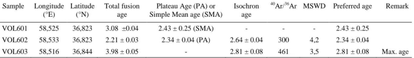
5. 40Ar/39Ar dating 78
5.1. Sampling and analytical procedure 78
5.2. Dating result 78
6. Modern stress state in the MTZ deduced from fault kinematics analyses 80
7. Summary and discussion 82
7.1. Reassessment of the historical seismicity pattern in NE Iran 84
7.2. Long-term strike-slip rates in the MTZ 85
7.3. Strike-slip faulting between the Binalud and Kopeh Dagh mountains 86
7.4. Kinematics of continental deformation in NE Iran 88
7.5. Changes in original boundaries of deforming zones 92
8. Conclusion 94
Acknowledgments 95
References 96
Appendix A: 40Ar/39Ar analytical procedure and data 102
C
HAPTER IIIXI
Abstract 107
1. Introduction 108
2. Active tectonic setting 110
3. Methodology 112
3.1. Geomorphic mapping and site selection 112
3.2. Sampling and estimating surface exposure ages 112
4. Morphotectonic investigations along the Neyshabur Fault System 114
4.1. The Binalud Fault zone 115
4.2. The Barfriz Fault 115
4.3. Cumulative fault offsets along the Barfriz Fault 118
4.4. The Buzhan Fault zone 121
4.5. Quantification of the Late quaternary fault offsets along the Buzhan Fault 123 5. Morphotectonic investigations along the Mashhad Fault System 130 5.1. Quantification of the cumulative fault offsets along the Mashhad Fault zone 134
6. Dating of the studied offset features 136
6.1. Neyshabur Fault System 136
6.2. Mashhad Fault System 139
7. Late Quaternary fault slip rates on both sides of the Binalud Mountains 139
7.1. Neyshabur Fault System 140
7.2. Mashhad Fault System 142
8. Summary and discussion 142
8.1. Deformation pattern of the Binalud Mountains 142
8.2. Examining active deformation pattern through geomorphic analysis 145
9. Conclusion 150
References 154
C
HAPTER IVPlio-Quaternary stress states in NE Iran: Kopeh Dagh and Allah Dagh-Binalud
mountain ranges 159
Abstract 161
1. Introduction 162
2. Tectonic setting 163
XII
3.1. Inversion of fault-slip data 165
3.2. Inversion of earthquake focal mechanism data 166
3.3. Data separation 166
3.4. Evaluation of stress tensor qualities 169
3.5. R values analysis 170
4. Fault kinematics and stress regimes 171
4.1. Modern state of stress 171
4.2. Intermediate state of stress 174
4.3. Paleostress state 176
5. Evidence for slip event chronologies from the fault zone observations 176 5.1. Structural evidence for the changes in the Plio-Quaternary states of stress 182
5.1.1. Central Kopeh Dagh 182
5.1.2. Western Kopeh Dagh 183
5.1.3. Binalud Mountains 185
5.2. Geomorphic evidence for stress changes from paleostress to modern stress
states 187
6. The present-day state of stress deduced from inversion of focal mechanisms 190
7. Summary and discussion 192
7.1. Temporal changes in the Plio-Quaternary stress states in NE Iran 193
7.2. Regional tectonic regimes 194
7.3. Consistency of the inversion results with previous studies 196
7.4. Tectonic implications 197
7.5. Dynamics of the stress changes in NE Iran 200
8. Conclusion 201
Acknowledgements 201
References 202
CONCLUSION 207
SYNTHESE FRANÇAISE:
Tectonique active du Nord-est de l’Iran et accommodation de la convergence entre l’Arabie et l’Eurasie: contribution des chaînes du Kopeh Dagh et du
Binalud 217
1. Introduction 217
XIII
3. Tectonique active dans la zone de transfert de Meshkan 222
4. Tectonique active le long des versants Nord et Sud du Massif du Binalud 223 5. Etats de contraintes pendant le Plio-Quaternaire dans le Nord-est Iranien 224
6. Discussion 225
Références bibliographiques issues du travail doctoral 229
Autres références bibliographiques 229
REFERENCES 233
APPENDIXES
Comment to “Extrusion tectonics and subduction in the eastern South Caspian
region since 10 Ma“ 245
Abstract 245
Introduction
This dissertation focuses on active tectonics in northeast Iran comprised of the Kopeh Dagh and Allah Dagh-Binalud mountain ranges (Fig. 1). The Iranian plateau is deformed between the converging Arabian and Eurasian plates. Their convergence is principally taken up by the active Makran subduction zone to the South, in addition to shortening and strike-slip faulting accommodated by crustal structures, which are non-uniformly distributed in several continental deformation domains such as the Zagros, Alborz and Kopeh Dagh mountain ranges (Fig 1). The present-day tectonic features are the result of a long and complicated story since the closure of the paleo-Tethysian basins (Stöcklin, 1968).
The Arabia-Eurasia convergence is accommodated differently in western and eastern Iran. The present-day GPS-derived rate of the northward motion of Arabia with respect to Eurasia is estimated to be on the order of 22±2 mm/yr at Bahrain longitude, south of the Persian Gulf (Sella et al., 2002; McClusky et al., 2003; Vernant et al., 2004; Reilinger et al., 2006). At the southern boundary of the Iranian plateau, the active Makran subduction zone is accommodating a significant portion of the convergence at a rate of 13-19 mm/yr (Vernant et al., 2004). The western and southwestern sides of the Iranian plateau are marked by the Zagros Mountains, which are accommodating the total shortening between central Iran and Arabia at a present-day rate of 5 to 9 mm/yr (Hessami et al., 2006) by involving active folding and thrust faulting parallel to the belt accompanied by strike-slip faulting parallel or oblique
2
Figure 1. Shaded relief image of the Iranian plateau (GTOPO30 digital topographic data) showing its general morphology together with the main tectono-structural divisions. The white rectangle marks the area of study. The inset on the upper right shows the location in the Arabia-Eurasia collision framework. Gray arrows represent Arabia-Eurasia plate motions after Reilinger et al. (2006).
to the belt. Along the eastern side of the Iranian plateau, the northward motion between Iran and Eurasia is taken up by intracontinental right-lateral shear on N-trending strike-slip faults (Tirrul et al., 1983; Meyer and Le Dortz, 2007), at a rate of 7±2 mm/yr (Vernant et al., 2004; Tavakoli, 2007). Farther north, the Main Kopeh Dagh Fault system (MKDF) marks part of the northeast boundary of the Arabia-Eurasia collision. This 350 km-long fault corresponds to the intraplate boundary between Iran and Turan platform accommodating their relative motion at
3 a rate of 3 to 8 mm/yr (Trifonov, 1978; Reilinger et al., 2006). As a consequence, deformation domains to the North (Alborz, Kopeh Dagh, and Binalud ranges) should take up the residual deformation none absorbed by the southern deformation zones. In this context, the northeast Iran plays a key role in accommodating or transferring the deforming between central Iranian blocks and the Turan platform.
During the last decade, several studies carried out in the Zagros (e.g., Authemayou et al. 2006, 2009; Bayer et al. 2006; Regard et al. 2004, 2005; Talebian and Jackson 2004; Walpersdorf et al. 2006; Yamini-Fard et al. 2007; Navabpour, 2009), Alborz (e.g., Axen et al. 2001; Jackson et al. 2002; Masson et al. 2006; Ritz et al. 2006), and central Iran (e.g., Meyer and Le Dortz, 2007) have produced a better understanding of active deformation in these zones. Conversely, such detailed studies are less common in northeast Iran, where tectono-stratigraphic evolution of the Kopeh Dagh and Binalud mountains has been investigated by Afshar Harb (1979) and Alavi (1992), respectively. Late Cenozoic faulting as well as the accommodation mode of deformations was discussed by Tchalenko (1975), Lyberis and Manby (1999), Jackson et al. (2002), Hollingsworth et al. (2006, 2008).
At the scale of plate tectonics, the deformation of continental lithosphere seems to be distributed over zones up to a few hundred kilometers wide with the relatively aseismic blocks on both sides. This general character of actively deforming continental domains has led geo-scientists to propose two idealized end-member kinematic models. On one hand, it has been suggested that actively deforming regions are comprised of blocks or microplates. Most of the deformation occurs along major block bounding faults, with minor faulting but little internal deformation of the blocks themselves (Avouac and Tapponnier, 1993; Peltzer and Saucier, 1996; Replumaz and Tapponnier, 2003; Ryerson et al., 2006, Thatcher, 2007, and references therein). On the other hand, deformation is uniformly distributed and continents can be treated as a continuously deforming viscous medium, governed by the fluid-like solid-state flow of a viscous material (England and McKenzie, 1982; Vilotte et al., 1982; McKenzie and Jackson, 1983; England and Molnar, 1997; Flesch et al., 2001). In this scheme, faults play a minor role and slip in the brittle upper crust occurs on many faults with comparable slip rates. The strengths and limitations of each model have been widely discussed in review papers (Molnar, 1988; England and Jackson, 1989; Gordon and Stein, 1992; Thatcher, 1995; Thatcher, 2003, and references therein). However, there are perhaps a general agreement that the major unresolved issue is not which of the two extreme models is unconditionally correct, but how the observed deformation can be most usefully and simply
4
described and which intermediate case is most appropriate (e.g., Molnar, 1988; Thatcher, 1995).
Interestingly, NE Iran and specially the Kopeh Dagh (Fig. 1) were always referred as a key region to demonstrate the geological reliability of the continuous deformation model (McKenzie and Jackson, 1983, 1986; Jackson and McKenzie, 1984). On the basis of existing data provided by short-term instrumental seismicity and regional geological maps, active deformation in northeast Iran has always been described by predominant active thrust faulting parallel to the strike of isolated deforming zones (i.e., the Kopeh Dagh and Allah Dagh-Binalud mountains) without significant strike-slip faulting (e.g., Berberian and Yeats, 1999; Hollingsworth et al., 2008; Jackson and McKenzie, 1984). According to this model, unstable geometry of strike-slip faults combined with the thrusting, oblique to the boundaries of the deforming zone will require faults to rotate about a vertical axis until they become parallel to the zone boundary (McKenzie and Jackson, 1983, 1986; Jackson and McKenzie, 1984; Jackson et al., 2002). In this interpretation, kilometric strike-slip cumulative offsets along the NNW-trending faults within the Kopeh Dagh (Tchalenko, 1975; Afshar Harb, 1979) is described by continuum deformation processes, in which strike-slip faulting results from systematic block rotations around vertical axes (e.g., Hollingsworth et al., 2006, 2008). However, in the absence of detailed Quaternary fault maps and sufficiently well-constrained data about active faulting, it was difficult to demonstrate the ability of any kinematics model to describe active deformation in NE Iran. In any case, the absence of precise quantitative measures of regional continental deformation has been the chief obstacle in determining which model is able to describe the kinematics of deformation in actively deforming zones (Thatcher, 1995). Quantitative data, particularly offset amounts and slip rates on major faults hold the key to constrain these models. In this context, the study of the Quaternary faulting yields the most precise average velocities of slip on faults (e.g., Molnar, 1988; Thatcher, 1995; Replumaz and Tapponnier, 2003; Nyst and Thatcher, 2004).
Indeed, despite all the efforts made by previous workers to shed light on active tectonics in northeast Iran, this region still suffers from a lack of detailed structural and kinematics data and should be considered as a concealed segment in the geodynamic puzzle of the Arabia-Eurasia collision. This matter is made worse by the facts that northeast Iran is the second populated region and one of the most seismically active deformation domains in the country that has experienced at least nine large earthquakes (M ≥ 7) during the last six centuries (Tchalenko, 1975; Ambraseys and Melville, 1982; Berberian and Yeats, 1999, 2001).
5 Within this general context, one simple but fundamental question still needs an answer: how is taken up the deformation in northeast Iran? To deal with this question, the following main objectives need to be achieved:
(1) To provide a detailed structural pattern of active faults for which a precise 2-D fault geometry, structural relationships and possible interactions between major faults can be described.
(2) To estimate rate of active deformation by determining geologic and geomorphic Quaternary slip rates along the recognized major faults.
(3) To characterize the states of stress responsible for Plio-Quaternary deformations in order to better understand the active faulting kinematics.
(4) To analyze the distribution pattern of deformation allowing describing the kinematics of active deformation.
Those main objectives have been pursued thanks to a combination of multidisciplinary approaches (structural geology, tectonic geomorphology, and dating methods) based on the following rationale. In this study, identification and characterization of active faults rely first on the analysis of remote sensing data such as satellite imagery (Landsat ETM+ and SPOT5) and digital elevation models (Space Radar Topographic Mission), complemented with fieldwork surveys, in order to map the fault systems from the fault zone (~100 km) to the fault segment (~10 km) scales, as well as to localize the sites of interest that deserve detailed investigations. From this morpho-structural analysis, fault traces were determined and their activity was highlighted by the displaced Quaternary geomorphic markers (volcanic domes, fluvial terraces, alluvial fans, and river networks). Once identified, fault zones were replaced in their seismotectonic contexts by comparing for example their segmentation with the seismicity distribution (both instrumental and historical) or the fault kinematics (determined by the analysis of either fault slip vectors or offsets cumulated by geomorphic markers), and with the focal solution mechanisms. On several sites of interest, the detail analysis of geological features (fold axes, geological strata) and geomorphic markers affected by the fault activity allowed determining the displacements cumulated over time scales ranging from 5 millions of years to several thousands of years. When needed, the vertical and horizontal components of displacement were measured thanks to a high-resolution topography produced by differential kinematic GPS technique. The fault slip rates, integrated over the Holocene and the Pleistocene, were determined by the combination of the displacement measurements with the dating of the offset geomorphic markers. The dating methods depended on the nature
6
of the material constituting the offset markers and on the envisaged time scales (radiometric Ar/Ar dating and surface exposure dating using cosmogenic 10Be and 36Cl).
This manuscript is organized around four chapters that examine the active tectonics and fault kinematics in northeast Iran. Chapter 1 is dealing with Quaternary slip rates along the northeastern boundary of the Arabia-Eurasia collision zone (Kopeh Dagh Mountains, Northeast Iran). Chapter 2 aims at discussing a new tectonic configuration in NE Iran based on active strike-slip faulting between the Kopeh Dagh and Binalud Mountains. Chapter 3 presents and discusses the Late Quaternary fault slip rates on both sides of the Binalud Mountains. Chapter 4 investigates the Plio-Quaternary states of stress in the Kopeh Dagh and Allah Dagh-Binalud mountain ranges Altogether, the data and interpretations presented in those different chapters allows proposing a new geodynamic model that significantly clarifies the active tectonics of this complicated region.
Chapter 1 – Quaternary slip rates along the northeastern boundary of the Arabia-Eurasia collision zone (Kopeh Dagh Mountains, Northeast Iran).
Chapter 2 – New tectonic configuration in NE Iran: active strike-slip faulting between the Kopeh Dagh and Binalud Mountains.
Chapter 3 – Late Quaternary fault slip rates on both sides of the Binalud Mountains (NE Iran).
Chapter 4 – Plio-Quaternary stress states in NE Iran: Kopeh Dagh and Allah Dagh-Binalud mountain ranges.
This work was funded by the INSU-CNRS (France) and the International Institute of Earthquake Engineering and Seismology (IIEES, Iran), and permanently carried out at CEREGE – University of Aix – Marseille III. Funding was provided by the Dyeti and PNRN programs (INSU-CNRS), and ACI FNS program (French Ministry of Research), within the above mentioned co-operative agreement. SPOT images were provided thanks to the ISIS program (©CNES 2004 to 2007, distribution SPOT images S.A.).
7 References
Afshar Harb, A. (1979), The stratigraphy, tectonics and petroleum geology of the Kopet Dagh region, northeastern Iran, Ph.D. thesis, Petroleum Geology Section, Royal School of Mines, Imperial College of Science and Technology, London.
Alavi, M. (1992), Thrust tectonics of the Binalood region, NE Iran, Tectonics, 11(2), 360-370. Ambraseys, N., and C. Melville (1982), A History of Persian Earthquakes, Cambridge
University Press, Cambridge, UK.
Authemayou, C., Chardon, D., Bellier, O., Malekzade, Z., Shabanian, E., and Abbassi, M. (2006), Late Cenozoic partitioning of oblique plate convergence in the Zagros fold-and-thrust belt (Iran), Tectonics, 25, TC3002, doi:10.1029/2005TCOO1860.
Authemayou, C., Bellier, O., Chardon, D., Benedetti, L., Malekzade, Z., Claude, C., Angeletti, B., Shabanian, E., and Abbassi, M. R. (2009), Quaternary slip-rates of the Kazerun and the Main Recent Faults: active strike-slip partitioning in the Zagros fold-and-thrust belt, Geophys. J. Int., 178, 524-540, doi: 10.1111/j.1365-246X.2009.04191.x. Avouac, J.-P., and P. Tapponnier (1993), Kinematic model of active deformation in central
Asia, Geophys. Res. Lett., 20, 895-898.
Axen, G. J., Lam, P. S., Grove, M., Stockli, D. F., and Hassanzadeh J. (2001), Exhumation of the west-central Alborz Mountains, Iran, Caspian subsidence, and collision-related tectonics, Geology, 29(6), 559–562.
Bayer, R., Chéry, J., Tatar, M., Vernant, Ph., Abbassi, M., Masson, F., Nilforoushan, F., Doerflinger, E., Regard, V., and Bellier, O. (2006), Active deformation in Zagros-Makran transition zone inferred from GPS measurements, Geophys. J. Int., 165(1), 373–381. doi:10.1111/j.1365-246X.2006.02879.x.
Berberian, M., and Yeats, R. (1999), Patterns of historical earthquake rupture in the Iranian Plateau, Bull. Seism. Soc. Am., 89, 120–139.
Berberian, M., and Yeats, R. (2001), Contribution of archaeological data to studies of earthquake history in the Iranian Plateau, J. Structural Geology, 23, 563-584.
England, P. C., and J. A. Jackson (1989), Active deformation of the continents, Annu. Rev. Earth Planet. Sci., 17, 197-226
England, P., and D. McKenzie (1982), A thin viscous sheet for continental deformation, Geophys. J.R. Astron. Soc., 70, 295-321.
England, P., and P. Molnar (1997), Active deformation of Asia: From kinematics to dynamics, Science, 278, 647-650.
8
Flesch, L. M., A. J. Haines, and W. E. Holt (2001), Dynamics of the India-Eurasia collision zone, J. Geophys. Res., 106, 16,435-16,460.
Gordon, R. G., and S. Stein (1992), Global tectonics and space geodesy, Science, 256, 333-342.
Hessami, K., Nilforoushan, F., and Talbot, C. (2006), Active deformation within the Zagros Mountains deduced from GPS measurements, J. Geol. Soc. Lond., 163, 143–148.
Hollingsworth, J., Jackson, J., Walker, R., Gheitanchi, M. R., and Bolourchi, M. J. (2006), Strike-slip faulting, rotation and along-strike elongation in the Kopeh Dagh Mountains, NE Iran, Geophys. J. Int., 166, 1161-1177, doi:10.1111/j.1365-246X.2006.02983.x. Hollingsworth, J., Jackson, J., Walker, R., and Nazari, H. (2008), Extrusion tectonics and
subduction in the eastern South Caspian region since 10 Ma, Geology, 36(10), 763–766, doi:10.1130/G25008A.1.
Jackson, J. A., Haines, A. J., and Holt, W. E. (1995), The accommodation of Arabia–Eurasia plate convergence in Iran, J. geophys. Res., 100, 15,205-15,219.
Jackson, J., and McKenzie, D. (1984), Active tectonics of the Alpine-Himalayan Belt between western Turkey and Pakistan, Geophys. J. R. astr. Soc., 77(1), 185-264.
Jackson, J., Priestley, K., Allen, M., and Berberian, M. (2002), Active tectonics of the South Caspian Basin, Geophys. J. Int., 148, 214–245.
Lyberis, N., and Manby, G. (1999), Oblique to orthogonal convergence across the Turan block in the post-Miocene, Am. Assoc. Petrol. Geol. Bull., 83(7), 1135-1160.
Masson, F., Djamour, Y., Vangorp, S., Chéry, J., Tavakoli, F., Tatar M., and Nankali, H., (2006), Extension in NW Iran inferred from GPS enlightens the behavior of the south Caspian basin, Earth Planet. Sci. Lett., 252, 180–188.
McClusky, S., Reilinger, R., Mahmoud, S., Ben Sari, D,. and Tealeb, A. (2003), GPS constraints on Africa (Nubia) and Arabia plate motions, Geophys. J. Int., 155(1), 126– 138, doi:10.1046/j.1365-246X.2003.02023.x.
McKenzie, D., and Jackson, J. (1983), The relationship between strain rates, crustal thickening, paleomagnetism, finite strain, and fault movements within a deforming zone, Earth planet. Sci. Lett., 65, 182-202.
McKenzie, D., and Jackson, J. (1986), A block model of distributed deformation by faulting, J. Geol. Soc. London, 143, 349-353.
Meyer, B., and Le Dortz, K. (2007), Strike-slip kinematics in Central and Eastern Iran: Estimating fault slip-rates averaged over the Holocene, Tectonics, 26, TC5009, doi:10.1029/2006TC002073.
9 Molnar, P. (1988), Continental tectonics in the aftermath of plate tectonics, Nature, 335,
131-137.
Navabpour, P. (2009), Brittle tectonics and palaeostress reconstructions in the Zagros: passive palaeo-margin and continental collision, Ph.D. thesis, University of Nice – Sophia Antipolis, France.
Nyst, M., and W. Thatcher (2004), New constraints on the active tectonic deformation of the Aegean, J. Geophys. Res., 109, B11406, doi:10.1029/2003JB002830.
Peltzer, G., and F. Saucier (1996), Present-day kinematics of Asia derived from geologic fault rates, J. Geophys. Res., 101, 27,943-27,956.
Regard, V., Bellier, O., Thomas, J.-C., Abbassi, M. R., Mercier, J., Shabanian, E., Feghhi, K., and Soleymani, S. (2004), The accommodation of Arabia-Eurasia convergence in the Zagros-Makran transfer zone, SE Iran: a transition between collision and subduction through a young deforming system, Tectonics, 23, TC4007, doi:10.1029/2003TC001599. Regard, V., Bellier, O., Thomas, J.-C., Bourlès, D., Bonnet, S., Abbassi, M. R., Braucher, R.,
Mercier, J., Shabanian, E., Soleymani, S., and Feghhi, K. (2005), Cumulative right-lateral fault slip rate across the Zagros–Makran transfer zone: role of the Minab–Zendan fault system in accommodating Arabia–Eurasia convergence in southeast Iran, Geophys. J. Int., 162, 177–203, doi:10.1111/j.1365-246X.2005.02558.x.
Reilinger, R., et al. (2006), GPS constraints on continental deformation in the Africa-Arabia-Eurasia continental collision zone and implications for the dynamics of plate interactions, J. Geophys. Res., 111, B05411, doi:10.1029/2005JB004051.
Replumaz, A., and P. Tapponnier (2003), Reconstruction of the deformed collision zone between India and Asia by backward motion of lithospheric blocks, J. Geophys. Res., 108(B6), 2285, doi:10.1029/2001JB000661.
Ritz, J.-F., Nazari, H., Ghassemi, A., Salamati, R., Shafei, A., Solaymani, S. and Vernant, P., (2006), Active transtension inside central Alborz: A new insight into northern Iran– southern Caspian geodynamics, Geology, 34(6), 477–480. doi:10.1130/G22319.1.
Sella, G. F., Dixon, T. H., and Mao, A. (2002), REVEL: A model for recent plate velocities from space Geodesy, J. Geophys. Res., 107(B4), 2081, doi:10.1029/2000JB000033. Stöcklin, J., 1968. Structural history and tectonics of Iran: A review, Am. Assoc. Petr. Geol.
Bull., 52(7), 1229–1258.
Talebian, M. and Jackson, J. (2004), A reappraisal of earthquake focal mechanisms and active shortening in the Zagros mountains of Iran, Geophys. J. Int., 156(3), 506–526.
10
Tavakoli, F. (2007), Present-day kinematics of the Zagros and east of Iran faults, Ph.D. thesis, University of Joseph Fourier, France, Grenoble.
Tchalenko, J. S. (1975), Seismicity and structure of the Kopet Dagh (Iran, USSR), Phil. Trans. R. Soc. Lond., Series A, 278 (1275), 1–28.
Tirrul, R., Bell, I. R., Griffis, R. J., and Camp, V. E. (1983), The Sistan suture zone of eastern Iran, Geol. Soc. Am. Bull., 94, 134 – 150.
Trifonov, V., (1978), Late Quaternary tectonic movements of western and central Asia, Geol. Soc. Am. Bull., 89, 1059-1072.
Vernant, P., et al. (2004), Present-day crustal deformation and plate kinematics in the Middle East constrained by GPS measurements in Iran and northern Oman, Geophys. J. Int., 157(1), 381–398, doi:10.1111/j.1365-246X.2004.02222.x.
Walpersdorf, A., Hatzfeld, D., Nankali, H., Tavakoli, F., Nilforoushan, F., Tatar, M., Vernant, P., Chéry, J. and Masson, F. (2006), Difference in the GPS deformation pattern of North and Central Zagros (Iran), Geophys. J. Int., 167(3), 1077-1088. doi:10.1111/j.1365-246X.2006.03147.x.
Yamini-Fard, F., Hatzfeld, D., Farahbod, A.M., Paul, A. and Mokhtari, M. (2007), The diffuse transition between the Zagros continental collision and the Makran oceanic subduction (Iran): microearthquake seismicity and crustal structure, Geophys. J. Int., 170(1), 182–194.
Chapter I
This chapter is focused on active tectonics in the Kopeh Dagh Mountains, which corresponds to the main deformation domain in northeast Iran. The Kopeh Dagh range is bounded by the Main Kopeh Dagh Fault system accommodating the relative motion between Iran and Turan platform. This intraplate strike-slip deformation is principally transferred southeastward to the post-Miocene Bakharden-Quchan Fault System dissecting the Central Kopeh Dagh. Nevertheless, geological knowledge of the rate and kinematics of this deformation is largely insufficient. Our morphotectonic investigations are conducted along the Bakharden-Quchan Fault System to constrain the long-term slip rates, to fill the huge gap of time between geological and geodetic data sets. After a review of the geological setting and structural framework of the Kopeh Dagh Mountains, we present the active faulting evidence along the fault system. Then, we analyzed post-folding brittle deformation and the obtained fault slip rates together, in order to characterize active deformation pattern. Finally we estimate inception of the strike-slip faulting in the range.
13 Quaternary slip rates along the northeastern boundary of the Arabia-Eurasia
collision zone (Kopeh Dagh Mountains, Northeast Iran)*
Esmaeil Shabaniana, Lionel Siamea, Olivier Belliera, Lucilla Benedettia, Mohammad R. Abbassib
a
CEREGE - UMR CNRS, Université Aix-Marseille, IRD, Collège de France, Europôle de l'Arbois, BP 80, 13545 Aix-en-Provence Cedex 4, France
b
International Institute of Earthquake Engineering and Seismology, BP 19395-3913 Tehran, Iran
Abstract
The Kopeh Dagh is accommodating a large portion of the northward motion of Central Iran with respect to Eurasia, involving a major right-lateral strike-slip fault system (Bakharden-Quchan). This fault system corresponds to the north-eastern boundary of the Arabia-Eurasia collision, and can be considered as a lithospheric-scale tectonic feature. We present a well-constrained estimation of late Quaternary slip rates along two major strike-slip faults (the Baghan and Quchan faults) in this fault system, using in situ-produced 36Cl nuclide to date two offset alluvial fan surfaces. Combining detailed satellite image and digital topographic data analyses complemented with geomorphic field work allows quantifying the cumulative offset values of 940±100 and 360±50 m of the fan surfaces along the Baghan and Quchan faults, respectively. A total of 12 carbonate boulders from the fan surfaces were collected and dated. This yields minimum age of two episodes of fan abandonment at 280±16 (Baghan fault) and 83±4 ka (Quchan fault). Age estimates and measured offsets of the fans are consistent with respective maximum long-term fault slip rates of 2.8±1.0 and 4.3±0.6 mm/yr for the Baghan and Quchan faults over the Middle-Late Pleistocene. Applying the slip rates to cumulative post-folding offsets along the Baghan and Quchan faults indicates that strike-slip motion within the Kopeh Dagh may have started ~4 Ma. This constrains the timing of a major tectonic reorganization in the Kopeh Dagh, previously recorded through Arabia-Eurasia collision between 3 and 7 Ma. At the regional scale, the sum of total cumulative strike-slip offsets is about 35-40 km which implies a total maximum slip rate of about 9±2 mm/yr in the Central-Eastern Kopeh Dagh. This is resolved to average northward and westward slip rates of ~8 and ~4 mm/yr, respectively, for the Western Kopeh Dagh with respect to Eurasia. Our results also suggests that the localized strike-slip faulting in the Central Kopeh Dagh can be considered as an intercontinental movement between north-east Iran and Eurasia, accommodating about 80% of northward motion of Central Iran with respect to Eurasia.
Keywords: Seismicity and tectonics; Continental neotectonics; Continental tectonics: strike-slip and transform; Tectonics and landscape evolution.
14
1. Introduction
Tectonic deformations in Iran result from the Arabia-Eurasia convergence. This convergence took place by crustal shortening and strike-slip faulting in different intracontinental deformation zones, such as the Zagros, Alborz and Kopeh Dagh mountain ranges, and the active subduction zone of the Makran. The Kopeh Dagh range (Fig. 1) corresponds to the main deformation zone at the north-eastern boundary of the Arabia-Eurasia collision. During the last decade, several studies carried out in the Zagros (e.g., Authemayou et al., 2005; Authemayou et al., 2006; Bayer et al., 2006; Regard et al., 2004; Regard et al., 2005; Talebian and Jackson 2004; Walpersdorf et al., 2006; Yamini-Fard et al., 2007) and Alborz (e.g., Axen et al., 2001; Jackson et al., 2002; Masson et al., 2006; Ritz et al., 2006), have produced a better understanding of active deformation in these zones; such detailed studies are less common in the Kopeh Dagh (e.g., Hollingsworth et al., 2006; Masson et al., 2007; Tavakoli, 2007).
The northward motion of Arabia with respect to Eurasia is accommodated at a rate of 22±2 mm/yr at the longitude of Bahrain (McClusky et al., 2003; Reilinger et al., 2006; Sella et al., 2002; Vernant et al., 2004). According to the available geodetic data, this northward motion should be accommodated in north-eastern Iran (mainly in the Kopeh Dagh Mountains) at a rate ranging from 4 to 10 mm/yr (Masson et al., 2007; Reilinger et al., 2006; Tavakoli, 2007; Vernant et al., 2004), given angular relationships between block motions and major structures (Fig. 1).
The Kopeh Dagh Mountains form a NW-SE active belt separating Central Iran from Eurasia (Turan platform) (Fig. 1). This mountain range accommodates a significant part of the Arabia-Eurasia convergence not absorbed by the Makran subduction (Vernant et al., 2004), involving thrust faulting, left-lateral strike-slip (on minor faults) in the Western, and right-lateral strike-slip in the Central-Eastern Kopeh Dagh (Afshar Harb, 1979; Jackson and McKenzie, 1984) mainly accommodated along a large intracontinental fault system.
In the Kopeh Dagh, the fault slip rates have been estimated using approaches spanning very different time scales: the short-term (a few years) from geodetic analysis (Masson et al., 2007; Tavakoli, 2007; Vernant et al., 2004), and the long-term (~5 Myr), using geological data (Afshar Harb, 1979; Lyberis et al., 1998; Lyberis and Manby, 1999). Geodetic measurements give access to short-term, almost instantaneous rates that include both inter- and post-seismic deformation (Tapponnier et al., 2001). Such short-term rates are integrated over the last several years, and long-term geological slip rates do not necessarily need to be
15 identical, especially if strain build-up varies through the seismic cycle and on larger time scales (e.g., Dixon et al., 2003; Friedrich et al., 2003). Despite the geodynamical constraints brought by the previous studies, those may integrate different tectonic regimes and consequently variations of the slip rates. Detailed geomorphic data on fault activity is thus essential to better constrain the slip rates over the last several tens- to hundreds-of-thousands of years along the Arabia-Eurasia collision boundary in north-eastern Iran, to fill the huge gap of time between geological and geodetic data sets.
Figure 1. GTOPO30 image of northeastern Iran showing divisions of the Kopeh Dagh Mountains, the location of Bakharden – Quchan Fault System (BQFS) as well as other mountain ranges and structural units mentioned in the text. Right-lateral shear between Central Iran and Eurasia is taken up on the Main Kopeh Dagh Fault (MKDF), accommodated through the Kopeh Dagh on the BQFS (black-half arrows). White arrows and associated numbers are GPS horizontal velocities in a Eurasia-fixed reference frame in millimeters per year (Tavakoli, 2007). The inset with the box on the upper right shows the location in the Arabia-Eurasia collision. Gray arrows and associated numbers represent Arabia-Eurasia plate velocities. Rates are in millimeters per year (Reilinger et al., 2006).
16
This paper presents the first well-constrained estimation of Late Quaternary slip rates in the Kopeh Dagh Mountains, combining in situ-produced 36Cl exposure dating, detailed satellite image (Landsat and SPOT) analyses, and geomorphic field surveys. After a review of the geological setting and structural framework of the Kopeh Dagh Mountains, we present the active faulting evidence along the main fault system (Bakharden-Quchan Fault) within this mountain belt. Then, we describe the morpho-tectonic investigations conducted along two major strike-slip fault segments (Baghan and Quchan faults), allowing us determining individual Quaternary fault slip rates on the order of several millimeters per year. Our results imply that the Kopeh Dagh region has accommodated the deformation due to the collision between Arabia and Eurasia at a rate of roughly 9±2 mm/yr, suggesting that the Bakharden-Quchan Fault System can be considered as an intercontinental boundary between Iranian micro-plate and Eurasia, accommodating about 80% of northward motion of Central Iran with respect to Eurasia. Moreover, analyzing post-folding brittle deformation combined with the obtained fault slip rates leads to our estimate that the strike-slip faulting within the Kopeh Dagh Mountains began roughly 4 Ma ago.
2. Geological setting and structural framework
The Kopeh Dagh range forms a 600 km-long and up to 200 km-wide mountain belt between the Eurasian plate (Turan platform) to the North and the Iranian block to the South (Fig. 1). It includes 10-17 km-thick, Mesozoic and Tertiary sediments, which were folded during the Oligo-Miocene orogenic movements (Afshar Harb, 1979; Lyberis and Manby, 1999; Stöcklin, 1968). The emergence of the Kopeh Dagh has been diachronous, getting younger from the eastern toward the western part of the mountain range (Afshar Harb, 1979; Lyberis and Manby, 1999). Folding of the Mesozoic-Tertiary sedimentary rocks after the Miocene period indicates the closure of the Kopeh Dagh basin, and emplacement of the Kopeh Dagh Mountains as a consequence of the northward motion of the Arabian shield towards Eurasia (Afshar Harb, 1979; Lyberis et al., 1998; Lyberis and Manby, 1999). Kopeh Dagh deformation accommodates part of the convergence between the Turan platform to the North and the Lut-Central Iran blocks to the South.
In the North-West, the Kopeh Dagh range is bounded by the Main Kopeh Dagh Fault zone (MKDF) which has been named either the Main Fault Zone (Tchalenko, 1975), the main Kopeh-Dagh fault (Trifonov, 1978), or the Ashgabat fault (Lyberis and Manby, 1999). This 350 km-long fault corresponds to a fundamental, inherited basement structure (Amurskiy,
17 1971; Maggi et al., 2000) forming the NE margin of the Kopeh Dagh as the boundary between Iran and Turan platform, and is considered as a seismically active structure (Trifonov, 1978). The width of the MKDF ranges from ~6 km, northeast of Kizyl-Arvat, to ~20 km southwest of Bakharden, where it is intersected by the post-Miocene Bakharden-Quchan Fault System (BQFS) (Figs 1 and 2). This particular region has been suggested as the south-eastern limit of the clear surface expression of the MKDF (Hollingsworth et al., 2006).
The BQFS is constituted by active NNW-trending, right-lateral strike-slip fault segments dissecting the Central-Eastern part of the Kopeh Dagh range (Fig. 1). This fault system extends between the MKDF to the North, and the Binalud range, which can be regarded as the northern margin of Central Iran to the South. The BQFS is the surface expression of basement faults with a considerable cumulative lateral displacement at the surface (Afshar Harb, 1979; Amurskiy, 1971; Tchalenko, 1975). The lack of basement steps (gravity survey - Amurskiy, 1971) along these faults suggests also a predominance of lateral movements at depth. Combining the results of recent geodetic and geodynamic studies (Masson et al., 2007; Reilinger et al., 2006; Tavakoli, 2007; Vernant et al., 2004) as well as seismicity distribution, with large cumulative geomorphic (this study) and geologic feature offsets (e.g., Afshar Harb, 1979; Afshar Harb et al., 1987) observed along the BQFS, strongly implies that the BQFS can be interpreted as a continuation of the eastern Iran boundary, allowing Central Iran to move northward with respect to Afghanistan, as a part of Eurasia (Jackson and McKenzie, 1984; Vernant et al., 2004).
3. Active faulting along the Bakharden-Quchan Fault System (BQFS)
The BQFS is composed of 10 major, roughly parallel, NNW-trending faults or fault zones with individual segment lengths ranging from 40 to 140 km, corresponding to a 45 km-wide band of transpressive deformation (Figs 1 and 2). . Most of the fault segments were mapped on regional scale geological maps (Afshar Harb, 1982; Afshar Harb et al., 1980; Afshar Harb et al., 1987; Huber, 1977). Both on digital topography and satellite imagery, their parallel and straight surface traces indicate an array of nearly vertical faults (Fig. 2).
In the northwest, the BQFS bends into the MKDF without clear evidence of crosscutting relationships, which indicates the merging of the both fault systems (Fig. 2). Along the southern limit of the BQFS, the fault zone expression is not conspicuous but it may terminate in the Kashafrud-Atrak Valley between the Kopeh Dagh and Binalud mountain ranges (Hollingsworth et al., 2006).
19
In this study, analyses of satellite images combined with digital topographic SRTM data and direct field observations allowed us to investigate active faulting along the BQFS. Two different resolutions of satellite images (Landsat ETM+ and SPOT5 with pixel size of 14 and 5 m, respectively) were used for regional mapping. The entire fault system is mapped in detail with special attention to the relay zones and intersection points between different fault segments. This allows distinguishing, on a geometric and geomorphic basis, fault segments representative of the dominant structural pattern. Fig. 2 presents all the recognized Quaternary fault segments with a length longer than 10 km. Among the 10 individual main Quaternary faults and fault zones in the BQFS, the Baghan Fault and the Kurkulab-Quchan Fault zone (KQF) are considered as the two principal structures. The next two sections provide a set of short-term (~102 yr) and long-term (~106 yr) evidence to consider the KQF and the Baghan Fault as the major active structures in the Kopeh Dagh Mountains.
3.1. Instrumental and historical seismicity in the Kopeh Dagh Mountains
A long and detailed historical record of earthquakes in north-east Iran spans over the last nine hundred years (Ambraseys and Melville, 1982; Berberian and Yeats, 1999; Berberian and Yeats, 2001; Tchalenko, 1975). Along the BQFS, the relationship between seismicity and fault segments has already been discussed by Tchalenko (1975) and Ambraseys and Melville (1982), and recently re-evaluated by Hollingsworth et al. (2006) for modern large earthquakes in the western part of the region. Since the 19th century, the Kopeh Dagh region has experienced at least 12 large earthquakes with magnitudes ranging from 6.5 to 7.5, and almost all of those seismic events occurred in the vicinity of the BQFS (Fig. 2). In this context, the Baghan and Quchan faults are responsible for at least 6 of these large earthquakes
Figure 2. (a) Detailed Quaternary fault map of the Central-Eastern Kopeh Dagh and the Main
Kopeh Dagh Fault system, including recognized Quaternary faults with a length longer than 10 km (prepared in this study). Two rectangles marked by b and c are the region of Figs 2b and c. Abbreviations are as follows: MKDF, Main Kopeh Dagh Fault; KF, Kurkulab Fault; QF, Quchan Fault; BF, Baghan Fault; DF, Dorbadam Fault. (b) Historical and instrumental seismicity of the Kopeh Dagh. Focal mechanisms are mainly taken from the Harvard catalogue (http://www.globalcmt.org/CMTsearch.html) and McKenzie (1972). Epicenters are from the NEIC catalogue (http://neic.usgs.gov/neis/epic/epic_global.html). The regions of maximum destruction are mainly based on Tchalenko (1975) and Ambraseys & Melville (1982), with one of the 4th February 1997 Garmkhan earthquake from Hollingsworth et al. (2007). Thick-black lines are surface ruptures associated with the 1929 Baghan (Tchalenko, 1975) and 1997 Garmkhan (Hollingsworth et al., 2007) earthquakes. (c) LANDSAT image of the Kurkulab-Quchan relay fault zone; the Quaternary trace of the Quchan segment terminates as it splits into a horse-tail structure.
20
(Baghan earthquake: 1929; Quchan earthquakes: 1851(?), 1871-72, 1893, 1895 – Ambraseys and Melville, 1982; Tchalenko, 1975). When considering the macroseismic regions associated to these historical earthquakes, the band of maximum destruction appears to follow the trends of the Quchan and Baghan faults. There is no evidence for such seismicity along the other structures in this zone. This supports the major role of the Quchan and Baghan faults within seismogenic behavior of the Central-Eastern Kopeh Dagh.
3.2. Distribution of cumulative geological offsets in the Kopeh Dagh Mountains
To understand and quantify the contribution of the BQFS to the accommodation of the Quaternary deformation at a regional scale, distribution of post-folding brittle deformation in the Kopeh Dagh was carefully examined using satellite imagery, SRTM data and field observations (Fig. 3). This analyzes allowed us investigating detailed morphologies, total offset measurements, as well as the structural linkage between the different fault segments. At the regional scale, there is no geomorphic or geological evidence for a significant vertical component along the major strike-slip faults over the whole BQFS. This is in agreement with a predominance of lateral movements at depth (Amurskiy, 1971), as well as focal mechanism data (Fig. 2). In addition, according to our field observations, a fault rake (slip-vector on fault plane) ranging from 0 to 10 degrees (Fig. 4) can be considered as a characteristic value for strike-slip motions in the Kopeh Dagh. Taking this characteristic fault rake into account, a maximum vertical displacement on each fault segment might not exceed by 11% the associated lateral displacement. According to these observations, cumulative post-folding horizontal displacements can be measured directly on satellite images, thanks to parallel fold axes and well-stratified geological formations offset by strike-slip faults. The cumulative displacements measured along the BQFS segments range from 100 m to 18 km. Those measurements are presented as displacement isolines at a regional scale (Fig. 3), allowing us distinguishing the structural importance of each individual fault segment in the region. The North-eastern part of the region is occupied by the Turan platform where there is no deformation (Fig. 3). The largest portions of strike-slip movements are localized on the MKDF and the BQFS. Among the investigated faults, the KQF and the Baghan Fault are the most important ones, exhibiting maximum cumulative displacements of ~15 and ~10 km, respectively (Afshar Harb, 1979; Afshar Harb et al., 1987; Hollingsworth et al., 2006). As a result, the combined observations of large post-folding offsets and occurrence of major destructive earthquakes during the last three centuries, suggest that the KQF and the Baghan
22
Figure 4. Fault plane data indicating a characteristic rake value ranging from 1 to 10° for strike-slip faults within the Kopeh Dagh Mountains. (a) Fault rake angle versus fault azimuth. (b) Stereographic projection of the fault data including fault striations.
Fault can be considered as the major strike-slip faults and consequently the main seismogenic sources in the Kopeh Dagh Mountains.
3.3. The Kurkulab–Quchan Fault zone
The longest fault zone in the BQFS system is constituted by two major fault segments which connect the MKDF to the northern limit of the Binalud fault system (Fig. 2). This fault zone was previously considered to be the Quchan Fault (Hollingsworth et al., 2006). However, even if the Quchan Fault connects to the MKDF, there is no direct Quaternary structural linkage between these two fault zones. On the basis of our observations, we propose the name of Kurkulab-Quchan fault zone (KQF) for this complex structure.
The Quchan Fault is the longest segment of the KQF, which is the largest strike-slip fault zone in the BQFS. The Quchan Fault extends from the city of Quchan in the southeast to 24 km north of Germab village in the northwest (Fig. 2). As characteristic features, displaced geomorphic markers such as alluvial fans, beheaded drainages and offset active stream beds, indicate Quaternary activity along much of its length. More to the north, the Quaternary trace
Figure 3. (a) Regional distribution of cumulative strike-slip offsets (filled contours) and their
equivalent long-term slip rates (numbered contours) in the Kopeh Dagh Mountains. Slip rates are expressed in millimeters per year. GF, Gholaman Fault zone; SF, Shirvan Fault; other abbreviations as the caption of Figure 2. (b) Profiles along which distribution pattern of the cumulative geological offsets is presented through the Kopeh Dagh Mountains. Location of profiles is marked on Fig. 3a. It should be noted that the cumulative offset on the DF (<10 km) is undifferentiated sum of right-lateral displacement (the probable dotted line: ~6 km) and apparent offset due to oblique thrust faulting with respect to fold axes. (c) Total slip rates for paths A-A’, B-B’, and C-C’ shown in Fig. 3a. (d) And (e) SPOT5 image of the southern part of the GF and SF, respectively, two examples for cumulative geological offsets analyzed in this study.