HAL Id: hal-02738087
https://hal.inrae.fr/hal-02738087
Submitted on 2 Jun 2020HAL is a multi-disciplinary open access archive for the deposit and dissemination of sci-entific research documents, whether they are pub-lished or not. The documents may come from teaching and research institutions in France or abroad, or from public or private research centers.
L’archive ouverte pluridisciplinaire HAL, est destinée au dépôt et à la diffusion de documents scientifiques de niveau recherche, publiés ou non, émanant des établissements d’enseignement et de recherche français ou étrangers, des laboratoires publics ou privés.
Distributed under a Creative Commons Attribution - NonCommercial - ShareAlike| 4.0 International License
Evaluating the “Soil stabilisation and control of erosion”
ecosystem service provided by agricultural ecosystems
over the French territory
Joël Daroussin, Isabelle Cousin, Anaïs Tibi, Yves Le Bissonnais, Annette
Girardin, Anne Meillet, Philippe Choler, Olivier Therond
To cite this version:
Joël Daroussin, Isabelle Cousin, Anaïs Tibi, Yves Le Bissonnais, Annette Girardin, et al.. Evaluating the “Soil stabilisation and control of erosion” ecosystem service provided by agricultural ecosystems over the French territory. Global Symposium on Soil Erosion, May 2019, Rome, Italy. �hal-02738087�
GLOBAL SYMPOSIUM ON SOIL EROSION
15–17 MAY 2019 | FAO headquarters, Rome, Italy
PROCEEDINGS
GLOBAL SYMPOSIUM
ON SOIL EROSION
(GSER19)
Co-organized by
FAO Food and Agriculture Organization of the United Nations
GSP/ITPS Global Soil Partnership / Intergovernmental Technical Panel on Soils
SPI/UNCCD Science-Policy Interface of the United Nations Convention to Combat Desertification
Joint
FAO/IAEA Programme of Nuclear Techniques in Food and Agriculture
15–17 May 2019
FAO headquarters, Rome, Italy
©
Matteo Sala Food and Agriculture Organization of the United Nations
Required citation:
FAO. 2019. Proceedings of the Global Symposium on Soil Erosion 2019. Rome.
The designations employed and the presentation of material in this information product do not imply the expression of any opinion whatsoever on the part of the Food and Agriculture Organization of the United Nations (FAO) concerning the legal or development status of any country, territory, city or area or of its authorities, or concerning the delimitation of its frontiers or boundaries. The mention of specific companies or products of manufacturers, whether or not these have been patented, does not imply that these have been endorsed or recommended by FAO in preference to others of a similar nature that are not mentioned. The views expressed in this information product are those of the author(s) and do not necessarily reflect the views or policies of FAO.
ISBN 978-92-5-131684-9 © FAO, 2019
Some rights reserved. This work is made available under the Creative Commons Attribution-NonCommercial-ShareAlike 3.0 IGO licence (CCBY-NC-SA3.0IGO; https://creativecommons.org/licenses/by-nc-sa/3.0/igo).
Under the terms of this licence, this work may be copied, redistributed and adapted for non-commercial purposes, provided that the work is appropriately cited. In any use of this work, there should be no suggestion that FAO endorses any specific organization, products or services. The use of the FAO logo is not permitted. If the work is adapted, then it must be licensed under the same or equivalent Creative Commons license. If a translation of this work is created, it must include the following disclaimer along with the required citation: “This translation was not created by the Food and Agriculture Organization of the United Nations (FAO). FAO is not responsible forthe content or accuracy of this translation. The original [Language] edition shall be the authoritative edition.
Any mediation relating to disputes arising under the licence shall be conducted in accordance with the Arbitration Rules of the United Nations Commission on International Trade Law (UNCITRAL) as at present in force.
Third-party materials. Users wishing to reuse material from this work that is attributed to a third party, such as tables, Figures or images, are responsible for determining whether permission is needed for that reuse and for obtaining permission from the copyright holder. The risk of claims resulting from infringement of any third-party-owned component in the work rests solely with the user.
Sales, rights and licensing. FAO information products are available on the FAO website (www.fao.org/publications) and can be purchased through publications-sales@fao.org. Requests for commercial use should be submitted via: www.fao.org/contact-us/licence-request. Queries regarding rights and licensing should be submitted to: copyright@fao.org.
i
Contents
KEY NOTE SPEECHES ... 1
Soil erosion in the Anthropocene: do we still need more research ?... 1
Decision supporting framework for foil erosion control and ecosystem services enhancement ... 3
Accelerated Soil Erosion by Water as a Source of Gaseous Emissions ... 7
Modelling post-fire soil erosion in recently burned areas ... 11
THEME 1: SOIL EROSION ASSESSMENT TOOLS AND DATA; CREATION,
CONSOLIDATION AND HARMONIZATION ... 17
Badland and gully erosion assessment using remotely sensed data, non-invasive field techniques and stochastic modelling approaches ... 17
Resilience of red ferralitic soils in the karst regions of Mayabeque, Cuba ... 25
Recalibration of a modified version of the WaTEM/SEDEM model for the assessment of soil erosion, sediment transport and the impact of soil erosion measures in Flanders ... 30
Soil erosion modelling using RUSLE1 in Shida Kartli Region, Georgia ... 35
Interpretation of Land use and Soil Conservation Measures in the Pan-Third Pole area using Google Earth High Resolution Remotely Sensed Images ... 39
Soil erosion modelling tools for the use in Earth system models ... 43
Measuring gullies and evaluating soil properties in a mountainous region of Rio de Janeiro State, Brazil ... 48
Comparing erosion rates and processes after land use conversion from rainfed to irrigated crops in fragile areas with water scarcity ... 54
Using PAP/RAC model and GIS tools for mapping and study of water erosion processes in the Mediterranean environment: Case of the Asfalou watershed (Oriental Rif, Morocco) ... 59
Calibration and validation of an USLE model to map soil erosion by water in the Sicilian Region (Italy) ... 69
Possibilities and precision of volumetric analyses of ephemeral gullies via UAV monitoring ... 75
Protocol to identify and assess soil degradation by erosion in Colombia ... 79
Soil erosion assessment using RUSLE and Projection Augmented Landscape Model (PALM) as a participatory tool in a Mexican peasant community ... 83
ii
Evaluating the “Soil stabilisation and control of erosion” ecosystem service provided by agricultural
ecosystems over the French territory ... 93
Integrated Approach to Conduct Global Soil Erosion Survey and Assessment under FAO Leadership ... 98
Introduction of three nuclear techniques integrated in order to strengthen in the Latin American and Caribbean region, the strategies and programs of surveillance/monitoring of the sedimentation phenomenon in water reservoir superficial ...102
Is an expert-based model able to map erosion in agricultural catchment ? ...109
Assessment of soil erosion by R/USLE – A case study of the applications of R/USLE in the mining industry ...116
Soil water available capacity affected by erosion in olive groves under semi-arid climatic conditions ...122
Preliminary progress on global soil erosion assessment ...129
Soil erosion in Russia: state, dynamics, and forecast ...134
A Survey of Soil Erosion in China of 2011 ...139
National Assessment of Soil Erosion in Canada from 1971 to 2016 ...144
National study of soil degradation by erosion in Colombia ...149
Assessment methods or tools in soil erosion control in the Pacific Island Countries and Territories ...155
Assessment of water and wind erosion risk over the Eastern Africa region ...159
Spatio-temporal monitoring of soil erosion events ...164
A large-scaled analysis on the spatial variability of soil parameters and its relation to soil erodibility and landscape characteristics in Southern Italy (Molise Region) ...170
Water erosion and the ENSO phenomenon over Penisetum chilense steppe of Puna region ...175
Erosion model testing – are doing enough? ...180
Long-term monitoring of sediment yield in typical agricultural watersheds of Navarre, Spain ...185
Merging remote and in-situ land degradation indicators in soil erosion control system ...190
Factors controlling the spatial distribution of sediment yield and area-specific sediment yield on large scale: example of Morocco ...196
Using fingerprint methods to implement effective strategies for management, sustainable use and conservation of the Brazilian Atlantic Forest ecosystems ...202
iii
Estimation of Soil Erosion Deforestation-induced Using Nuclear Techniques (Case study: Golestan
Province, Iran)...212
Dynamic Erosion Model and Monitoring System (DEMIS) at the National Scale in Turkey ...217
Simulation and evaluation of global sediment runoff and soil organic carbon removal by erosion in maize fields under varying field management ...224
Downscale LS derived from 1-arc SRTM in Global Soil Erosion Assessment ...230
Soil erosion intensity and SOM dynamics: traditional cultivation vs. perennial cover crop ...236
An investigation of the relationship between flow characteristics and soil erosion indices ...241
Evaluation of soil erosion risk and identification of soil cover and management factor (C) for RUSLE in European vineyards with different soil management ...246
Models erosion as methodical basis combating its manifestations in Ukraine ...251
Soil erosion as a source of sediment and phosphorus in Vltava River basin ...256
Soil Erosion Risk in the Rainy Mountainous Area of Eastern Mediterranean...260
A contribution to the analysis of urban erosion in Kinshasa, DRC. ...267
Comparison of RUSLE model and UAV-GIS methodology to assess the effectiveness of temporary ditches in reducing soil erosion ...273
(R)USLE factors obtained in standard plots: a critical analysis, opportunities and challenges related to the database in Brazil ...279
Application of the EUROSEM model in drainage basins in areas of the Valencian Community, Spain ...284
Use of geochemical fingerprints to trace sediment sources in an agriculture catchment of Argentina ...289
Rainfall Erosivity in China ...294
THEME 2: POLICIES AND PRACTICES TO ADDRESS SOIL EROSION ... 300
Zeolite effects on soil organic carbon and structure against erosion in vineyards ...300
Effects of biochar on soil properties and erosion potential in a degraded sandy soil ...305
Soil and water conservation technics as a mechanism to adapt to the impacts of climate change in the Maule River Basin Chile ...310
The Potential of Goji Berry Tree to Control Soil Erosion in Cameron Highlands, Malaysia ...316
A possible approach to control soil erosion: natural farming ...323
iv
How is soil erosion evaluated in the land capability systems used in Brazil? ...334
Effectiveness Analysis of Agricultural BMPs by SWAT Model for Appropriate Control of Sediment Yield on the Kalaya Catchment in the North of Morocco ...339
Role of biochar to counteract degradation in acid soils ...342
Assessing Soil Health Following the Adoption of Conservation Agriculture in East Africa ...347
Soil Degradation and Erosion Processes under New Extensive Agro-Industrial Developments: Causes and Consequences ...351
From Soil Erosion to Soil Accumulation: Recycling Urban Organic Waste to the Eroded Land in Sahel, West Africa ...357
Soil quality assessment by enzyme activities in an olive orchard subjected to living mulch to counteract soil erosion ...364
Influence of mosses on soil hydraulic conductivity, penetration resistance and water repellency six years after a post-fire salvage logging treatment...369
Use of perennial crop (Arundo Donax L.) in two degraded areas to control soil erosion and improve soil quality ...374
Long-term effectiveness of Sustainable Land Management practices to control runoff, soil erosion and nutrient loss in Mediterranean rainfed agroecosystems ...380
Soil loss impacts on food security: a case study on LSLA in Mozambique ...387
Soil protection from erosion on the local level in Kharkiv region, Ukraine ...390
Environmental assessment of land management interventions, Atlantic Morocco ...395
Termite footprints in restored versus degraded agrosystems in southwestern Niger...400
Soil carbon storage in Mediterranean forest stands: implications in the restoration of eroded soils ...405
Assessing the effectiveness of Sustainable Land Management for large-scale climate change adaptation ...410
Using ‘No-tillage’ farming technique as an assessment tool in soil erosion control study on highly acidic soils formed from the volcanic origin, common in Micronesia ...415
No-till effect on soil erosion in mid-slope cropping through soil aggregates stability and fallout radionuclides ...421
Novel biotechnological methods of soil erosion control to achieve sustainable development goals: economic growth, food self-sufficiency, and clean water ...426
Conservation and Traditional Agriculture Impacts on Soil in the Peruvian’s highlands ...431
Erosion-induced soil toxicity undermined maize-bean responses to sustainable land management practices on Mount Wanale in eastern Uganda ...436
v
Surface creep, saltation and suspension with large and medium aggregates: a wind tunnel experiment ...442
Increasing soil chemical properties through the application of rock fines in tropical soils in west Cameroon, Africa ...447
Building a solid foundation for erosion control: resilience-based stewardship in Burundi ...453
Reinforce Water and Climate Co-benefits in Actions to Control Soil Erosion ...458
Agricultural defense of Sao Paulo: Twelve years of soil preservation and rehabilitation at the Rio do Peixe watershed, promoting conservation agriculture ...461
Soil erosion policy in Switzerland ...468
The conceptual model for natural resources conservation in forest areas ...474
Challenges and Opportunities: Enabling Effective Soil Erosion Control through Land Degradation Neutrality ...480
Vulnerability assessment of soil erosion affected by climate change ...481
Soil conservation knowledge governance in Mexico ...485
Using the SedNetNZ model as a policy planning tool in the Hawke’s Bay region of New Zealand ...491
Reversing soil erosion trends at the river basin scale: A participatory model of intervention for building resilience in developing countries ...496
15 years of experience with the use of detailed erosion maps in soil erosion policy in Flanders, Belgium ...502
Supporting Regionally Integrated Agro-Forestry practices in Mountain Regions to Prevent Erosion, comparing China-EU Cases ...507
National Plan participatory construction against Soil Erosion in Brazil ...513
Integrating data and assessment evidence across disciplines to co-design soil erosion solutions in degraded pastoral land ...520
An integrated approach to tackle soil erosion – insights from Burundi ...525
Soil and water conservation policy evolution and its human-environment contexts in China since 1949 ...528
The evolution of soil conservation policies targeting land abandonment and soil erosion in Spain: A review ...534
The New Zealand Soil Erosion Control Experience 1919 to 2019: Lessons for Policy and Practice ...539
Education for soil science conservation research with children from the Alto del Naranjo village in the municipality of Manizales Caldas, Colombia ...542
vi
The impact of plans, policies, practices and technologies based on the principles of conservation
agriculture for controlling soil erosion in Brazil ...553
Socio-Economic and Policy Issues Associated with Increasing Erosion and Sedimentation in the River Basins and Coastal Zones of Kerala ...559
Policy framework on soil erosion and land degradation from the post conflict perspective of Bosnia and Herzegovina ...564
A Generic Policy and Implementation Model to Address Soil Erosion ...571
Western Balkan Countries vs. Mediterranean Region Policy on Soil Erosion...575
Promoting the Adoption of Soil Conservation Practices in Manitoba ...578
Collective action in the face of the water crisis and desertification in the Atacama Desert. ...582
THEME 3: THE ECONOMICS OF SOIL EROSION PREVENTION, MANAGEMENT
AND REMEDIATION ... 588
Sustainability and production: analysis of a successful soil conservation strategy in the province of Entre Ríos, Argentina...588
Farmers’ preferences for controlling soil erosion in Sicily ...595
Economic evaluation of water erosion and Sustainable Land Management ...600
Challenges and opportunities to scale up the application of sustainability guidelines and voluntary standards ...604
The economics of soil erosion and benefits of sustainable land management in Asia and Africa ...609
Economic Analysis of Soil Erosion Control in New Zealand: Robust Identification of Benefits, Costs and Investment Priorities at the National Level ...614
A synergy between the biophysical and the economic: the global market impacts of soil erosion ...617
Mapping soil loss by water erosion in Argentina and analysis of its economic impact ...622
Economics of soil erosion in Ukraine ...628
Assessment of the Cost of Soil Erosion to Crop Production in Canada ...633
Assessing land consumption impact on ecosystem services provision: an insight on biophysical and economic dimension of loss of erosion control in Italy ...638
20 years of lessons learned with the application of economic-environmental incentives in national programs of erosion control in degraded soils, Chile ...644
vii
SIDE EVENT: “SOIL EROSION ASSESSMENT: MAKING A DIFFERENCE WITH
ISOTOPIC TECHNIQUES”, ORGANIZED BY THE JOINT FAO/IAEA PROGRAMME
OF NUCLEAR TECHNIQUES IN FOOD AND AGRICULTURE ... 654
Stable and radiogenic isotope approaches to assess on-site and off-site soil erosion processes ...654 Use of fallout radionuclides to assess change in soil erosion and sedimentation rates in Northern
Morocco...656 Madagascar highland traditional terracing agriculture improves soil preservation, as evidenced by
fallout radionuclide techniques ...661 Use of 137Cs in evaluating conservation agriculture practices on soil erosion control in semi-arid areas
1
Key note speeches
Soil erosion in the Anthropocene: do we still need more research ?
Jean Poesen
Department of Earth and Environmental Sciences, KU Leuven, Leuven, Belgium
Abstract
Taking steps to preserve the quality and quantity of global soil resources should require no justification. Our future ability to feed ourselves and live in an unpolluted environment in the Anthropocene depends on our ability to reduce the rates at which our soils are currently eroding. The current and expected unprecedented environmental changes at a global scale make this task even more urgent.
Soil erosion is a geomorphological and, at the same time, a major land degradation process that may cause environmental and property damage, loss of livelihoods and services as well as social and economic disruption. Erosion not only lowers the quantity and quality of soils on-site, but causes also significant sediment-related problems off-site. Addressing the problem of soil erosion therefore requires a thorough understanding of the various erosion processes, their interactions, their controlling factors and their spatial extent. Given the large number of research papers on this topic, one might think that we know now almost everything about soil erosion and its control so that little new knowledge can be added.
This conclusion can be refuted by pointing to some major research gaps. These are: (1) improved understanding of both natural and anthropogenic soil erosion processes and their interactions, (2) scaling up soil erosion processes and rates in space and time, and (3) innovative techniques and strategies to prevent soil erosion or reduce erosion rates.
Many soil erosion assessments have focused on sheet and rill erosion, particularly in cropland, yet an increasing number of field observations also points to other significant water water-erosion related processes (both in cropland as well as in rangeland) such as gully erosion and piping erosion which are rarely incorporated in assessments of soil erosion rates by water. In the Anthropocene, soil losses by human activities (anthropogenic soil erosion) have also become very significant: e.g. tillage erosion, soil erosion by land leveling, soil quarrying, crop harvesting (mainly root and tuber crops), explosion cratering and trench digging. Most soil erosion studies focused on a single erosion process. However, in many environments several erosion processes operate at the same time and may interact with each other resulting in a reinforcement or compensation of soil loss rates. Some examples are wind and water erosion, piping and gully erosion, gully erosion and landsliding, ephemeral gully erosion and tillage erosion/deposition, soil erosion by animal trampling and water or wind erosion. These erosion process interactions call for integrated assessments of soil erosion rates at various spatial and temporal scales. Too often researchers have been biased towards a particular (natural) erosion process. There is however, an urgent need to quantify also anthropogenic soil erosion rates in such assessments.
Addressing these research gaps will (1) allow us to better understand processes and their interactions operating at a range of spatial and temporal scales, to better predict their rates as well as their on-site and off-site impacts, which is academically spoken rewarding, and (2) put us in a better position to select the
2 most appropriate and effective soil erosion control techniques and strategies which are crucial for a sustainable use of our soils in the Anthropocene.
Keywords: sheet and rill erosion, gully erosion, piping, tillage erosion, land leveling, crop harvesting, anthropogenic erosion, process combinations
The views expressed in this information product are those of the author(s) and do not necessarily reflect the views or policies of FAO.
References
Poesen, J. 2018. Soil erosion in the Anthropocene: Research needs. Earth Surface Processes and
3
Decision supporting framework for foil erosion control and ecosystem services
enhancement
Jae E. Yang*
Dept. of Biological Environment, Kangwon Nat’l Univ., Korea 24341
Kyoung Jae Lim
Dept. of Regional Infrastructure Eng., Kangwon Nat’l Univ., Korea 24341
Pasquale Borrelli
Environmental Geosciences, Univ. of Basel, CH-4056 Basel, Switzerland
Abstract
The objective of this work is to propose a decision supporting framework for the planning, assessment, and policy of soil and water conservation, by integrating both soil erosion and ecosystem services. The WEB GIS-based portal system was developed as a tool for soil management using various datasets such as those that give soil properties, topography, hydrology, climate, maps, and land use at the watershed level. Through the portal system, soil erosion and quality can be predicted, and soil ecosystem services can be assessed based on soil function indicators, such as biomass production, groundwater recharge, biodiversity, organic carbon storage, and pollution buffering. After both soil erosion and ecosystem services are categorized into five levels, the priority areas for soil conservation can be designated. Soil and water conservation planning can be formulated using the specific best management practices (BMP) at designated areas, followed by the assessment of BMP effects on soil erosion and ecosystem services. The system provides the framework to develop a strategy and policy for soil and water conservation to enhance soil ecosystem services and minimize soil erosion. Accordingly, the conservation policy can incorporate an incentive, such as a direct payment along with a farmer’s cross compliance, and this policy can be proposed to policymakers.
Key words: soil erosion, ecosystem services, Web-GIS soil management system, conservation policy
Introduction
Soil erosion is a primary cause of soil degradation. Soil erosion and degradation reduce food production, become threats to climate action and human health, and degrade air and water quality with particulates, sediment, and nutrient runoff. Thus, soil erosion is one of the major soil threats that can decrease the capacity of the soil ecosystem in providing diverse benefits (i.e., ecosystem services) to the environment and humans, which are closely related with the achievement of the UN Development Goals. Ultimately, the goals of sustainable soil management should increase soil ecosystem services and decrease soil threats. If soil erosion and other challenges, including population growth and food security, remain unconstrained from their current rates, humankind may lose the ability to feed itself (Ascough et al., 2018).
A number of soil erosion models, with varying degrees of complexity and spatio-temporal scales, have been developed to predict the amount of soil erosion (empirical models) and to describe the soil erosion process (process-based models). Karydas et al. (2012) classified 82 soil erosion models into 8 categories based on spatial scale, temporal scale, and spatial methodology. Process-based models are used to assess the impacts of agricultural practices on water and air quality for both on-site and off-site erosion problems under specific environmental conditions (Ascough et al., 2018). However, modelling output is, in many cases, confined to
4 the assessment of the amount of soil erosion and not further linked to policy for implementation of sustainable soil management.
Ecosystem services (ES) are holistic concepts, and they consist of supporting, provisioning, regulating, and cultural services (MEA, 2005). These services can be estimated by integrating soil functions and properties, and soil values can be assessed quantitatively at different levels based on the ES estimated. Humanity will demand more ES from soil and water resources in the future.
Without implementing policies for conservation practices to confront the challenges that humanity faces in the future, we will not be able to achieve sustainable levels of food production needed to feed the growing world population (Delgado et al., 2011; Sassenrath and Delgado, 2018). Policies for the implementation of sustainable soil management should consider both soil erosion and soil ES. The objective of this presentation is to propose a policy that supports the framework for the goal of sustainable soil management by considering both soil ecosystem services and soil erosion based on case studies in Korea and elsewhere. WEB-GIS based soil portal system for soil management
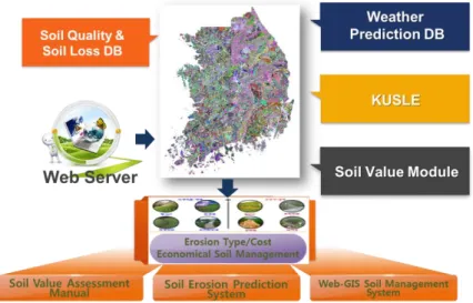
The soil portal system (Figure 1) is composed of a data base; soil quality and value estimation modules; a soil erosion prediction module; and information about land use, watershed hydrology, and the climate. Using big data sets that include soil properties and erosion indicators, amounts of soil erosion are predicted by the Korea Soil Loss Equation (KORSLE) (Lim et al., 2018; Rasal et al., 2018), which is a modified version of USLE and predicts monthly soil erosion employing Korean soil and rainfall data. At the same time, soil quality and values are quantitatively assessed based on the ES that a specific soil can provide. Both soil erosion and soil value are categorized into five levels. The portal system can evaluate the impact of the best management practices (BMP) on the changes of soil erosion and ecosystem services, and the results can be the basis for policy development for soil and water conservation.
Figure 1: Basic concept of the WEB-GIS soil portal system for soil management.
Framework for soil erosion control and ecosystem services enhancement
Figure 2 shows a schematic flowchart of the framework for the development of a conservation policy to control soil erosion and increase soil ES. Using the soil erosion and ES levels assessed in the portal system,
5 priority areas of soil conservation at the watershed level can be designated. Soil and water conservation planning, based on implementing a specific BMP and its impact assessment, is possible at the watershed level when considering changes of ES values. Accordingly, a conservation policy that incorporates an incentive, such as a direct payment along with a farmer’s or land owner’s cross compliance, can be proposed to policymakers.
This framework can be modified for different countries having different spatio-temporal scales, and it can depend on data availability. Further long-term validation is definitely needed to improve the credibility of the framework for use by farmers or land owners. However, the proposed framework provides a protocol useful for holistic planning of soil and water conservation and policy implementation.
Figure 2: A proposal of the decision supporting framework for soil erosion control and ecosystem services enhancement.
6 Acknowledgement
This work is supported in part by the Rural Development Administration Project (PJ14141), Korea Environmental Industry and Technology Institute GAIA Project (No: 2014000540003) and Ministry of Environment SS Projects (2019-002820004).
The views expressed in this information product are those of the author(s) and do not necessarily reflect the views or policies of FAO.
References
Ascough, J.C., Flanagan, D.C., Tatarko, J., Nearing, M.A. & Kipka, H. 2018. Soil erosion modeling and conservation planning. In: J.A. Delgado et al. (eds), Precision conservation: geospatial techniques for
agricultural and natural resources conservation. Agronomy Monograph, Soil Science Society of America,
Madison, WI, USA. p.1-25.
Delgado, J.A., Groffman, P.M., Nearing, M.A., Goddard, T., Reicosky, D., Lal, R., Kitchen, N.R., Rice, C.W., Towery, D. & Salon, P. 2011. Conservation practices to mitigate and adapt to climate change. J. Soil Water
Conserv., 66:118A-129A.
Karydas, C.G., Panagos, P. & Gitas, I.Z. 2014. A classification of water erosion models according to their geospatial characteristics. Int. J. Digital Earth, 7:229-250.
Lim, K.J., Park, Y.S., Kim, M.K., Jeong, J., Engel, B.A., Munoz-Carpena, R. & Kim, J. 2018. Design of vegetative filter strip using web-based system with groundwater table and pesticide degradation analysis modules.
Journal of Hydrological Engineering, 23(2). DOI: 10.1061/(ASCE)HE.1943-5584.0001611.
Millennium Ecosystem Assessment (MEA). 2005. Millennium Ecosystem Assessment Full Reports. Island Press. Washington, D.C. USA.
Rasal, A., Lim, K.J., Bhattarai, R., Yang, J.E., Noh, H., Pathak, R. & Kim, J. 2018. Development of web-based WERM-S module for estimating spatially distributed rainfall erosivity index (EI30) using RADAR rainfall data.
Catena, 161:37-49.
Sassenrath, G.F. & Delgado, J.A. 2018. Precision conservation and precision regulation. In: J.A. Delgado et
al. (eds), Precision conservation: geospatial techniques for agricultural and natural resources conservation.
7
Accelerated Soil Erosion by Water as a Source of Gaseous Emissions
Rattan Lal*
Carbon Management and Sequestration Center at the Ohio State University United Nation Convention to Combat Desertification (UNCCD), Bonn, Germany
Abstract
The urgency to limit the global warming to 1.5°C has enhanced interest in the identification of sources and sinks of greenhouse gasses (GHGs). Global land use and land use change (LULUC) are important source of GHGs both directly (i.e., farm operations, soil tillage, drainage of wetlands, grain drying) and indirectly (e.g., hidden carbon costs of inputs such as fertilizer, pesticides, food processing and transport). The atmosphere concentration of CO2 at 405.5 ± 1 ppm in 2017, 146 % more relative to that in 1750, is increasing at the rate of 2.24 ppm/yr or 0.55%/yr (WMO, 2018). For the decade of 2008 – 2017, total average annual emission of 10.9 Pg C/yr comprised of 9.4 ± 0.8 Pg C/yr from fossil fuel combustion and 1.5 ± 0.7 Pg C/yr from LULUC. Of this, 4.7 ± 0.02 Pg C/yr was absorbed by the atmosphere, 2.4 ± 0.5 Pg C/yr by the oceans, 3.2 ± 0.8 Pg C/yr by land, and the remainder imbalance of 0.5 Pg C/yr (Le Quéré et al., 2019). Thus land-based sinks absorbed about 29.4% of the total emissions. However, not all the sources of GHGs are identified in the global carbon budget presented above. Emission of GHGs from transport, redistribution and deposition of C-laden sediments by water and wind erosion at global scale are not being considered in the global carbon budget. Yet, erosion is a source of GHGs at all the four stages (i.e. detachment, transport, redistribution, and deposition) (Figure 1). Depending upon the soil moisture content and the degree of saturation, soil organic matter (SOM), being transported and deposited by erosional processes, is subject to both aerobic and anaerobic processes leading to emissions of CO2, CH4, and N2O (Worrall et al., 2016). Soil erosion processes by water transport as much as 60.6 Pg C/yr with reservoir trapping (Walling, 2008, 2009). Global soil erosion by water redistributes a large quantity of SOC prone to mineralization under aerobic and anaerobic conditions. Assuming delivery ratio of 10 %, SOC concentration of 2 % and mineralization rate of 20 %, the magnitude of C emitted by erosional processes may be as much as 2.4 Pg C/yr. Lal (2003) estimated the global erosion-induced emissions at 1.1 Pg C/yr. Further, the problem of soil erosion may be exacerbated by the current and projected climate change (Segura et al., 2014). These estimates neither account for the methanogenesis nor the nitrification/denitrification which cause emission of CH4 and N2O, respectively. Thus, soil erosion being a large and net source of GHGs (Worrall et al., 2016; Kirkles et al. 2014), must be appropriately considered while assessing the global C budget. Further land use and soil/crop management practices must be adopted that can control soil erosion within the permissible limits to minimize the off-site damage of gaseous emission and non-point source pollution. Implementation of negative emission technology, especially those that effectively control soil erosion (i.e., conservation agriculture, vegetative contour hedges) and restore degraded soils (cover cropping, afforestation, 4 per thousand initiative) are important to creating a positive soil/ecosystem carbon budget and removing CO2 from the atmosphere. Reducing gaseous emissions caused by erosion and restoring degraded and desertified soils are in accord with the goal of achieving land degradation neutrality.
8 Introduction, scope and main objectives
Achieving land degradation neutrality is an important goal of UNCCD and is also integral to the Agenda 2030. Therefore, reducing risks of soil erosion and restoring degraded soils is critical to sustainable land use. The objective of this article is to describe the impact of erosional processes on the fate of soil organic carbon being transported and redistributed over the landscape, and deliberate innovative soil management options to reduce risks of erosion-induced emission of GHGs. The article is global in geographical scope, but is limited to the emission of CO2. Erosion-induced emissions of N2O and CH4, despite being significant in amount and characterized by high global warming potential, are not specifically discussed in this article.
Methodology
The data presented are based on collation and synthesis of articles published in peer reviewed journals. Information on gaseous emission and the fate of carbon transported at four different stages (Figure 1) was discussed and critically reviewed in this article.
Figure 1: Gaseous emissions at different stages of accelerated soil erosion by water.
Results
Global estimates CO2 – C emissions by water erosion range from 1.1 Pg C/yr to as much as 2.4 Pg C/yr. However, long-term data on watershed scale are needed to provide credible information on emissions of GHGs from diverse land use systems (e.g., croplands, grazing lands, forest lands, urban lands, mine lands) on major soil groups and eco-regional biomes.
Discussion
There is a strong need to strengthen scientific knowledge on processes, factors, and causes affecting the magnitude of emission of GHGs through soil erosion by water, wind, gravity, and other agents of erosion. Predictive models must be developed and validated against experimental data obtained from long-term field studies conducted on watershed basis.
Accelerated Soil Erosion
Detachment Transport Redistribution Deposition
CO2 CO2 CO2, CH4, N2O CO2, CH4, N2O
Positive Feedback to Climate Change
Accelerated Soil Erosion Increased Frequency of Extreme Events
M in er al iz ati on M in era liz at ion M etha no ge ne sis M in er al iz ati on N itri ficat ion D en itri ficat ion M et han oge ne si s M in er al izat ion N itri ficat io n D en itri ficat ion
9 Conclusions
Accelerated soil erosion is an important source of GHGs. Thus, site-specific conservation-effective management options must be identified and promoted to minimize the C-footprint of agroecosystems, to reduce the off-site impacts, and advance Sustainable Development Goals of the United Nation.
Acknowledgements
Funding support for participation in the symposium was provided by the UNCCD – SPI, Bonn Germany.
The views expressed in this information product are those of the author(s) and do not necessarily reflect the views or policies of FAO.
References
Chaplot, V. 2015. Soil erosion contributes significantly to global carbon emissions. Earth Surface Processes
and Landforms.
Chestney, N. 2012. Soil erosion increasing global warming threat: UNEP. Reuters, London, Environment. Favis-Mortlock, D.T. & Guerra, A. J. T. 2000. The influence of global greenhouse – gas emissions on future rates of soil erosion: a case study from Brazil using WEPP-CO2. Schmidt J. (eds) Soil Erosion. Springer, Berlin, Heidelberg, pp. 3-31.
Kirkels, F.M.S.A., Cammeraat, L.H. & Kuhn, N.J. 2014. The fate of soil organic carbon upon erosion, transport and deposition in agricultural landscapes — A review of different concepts. Geomorphology, 226: 94-105.
Lal. R. 2003. Soil Erosion and the global carbon budget. Environ Int, 29(4): 437-50.
Le Quéré, C., Andrew, R.M., Friedlingstein, P., Sitch, S., Hauck, J., Pongratz, J., Pickers, P.A., Korsbakken, J.I., Peters, G.P., Canadell, J.G., Arneth, A., Arora, V.K., Barbero, L., Bastos, A., Bopp, L., Chevallier, F., Chini, L.P., Ciais, P., Doney, S.C., Gkritzalis, T., Goll, D.S., Harris, I., Haverd, V., Hoffman, F.M., Hoppema, M., Houghton, R.A., Hurtt, G., Ilyina, T., Jain, A.K., Johannessen, T., Jones, C.D., Kato, E., Keeling, R.F., Goldewijk, K.K., Landschützer, P., Lefèvre, N., Lienert, S., Liu, Z., Lombardozzi, D., Metzl, N., Munro, D.R., Nabel, J.E.M.S., Nakaoka, S., Neill, C., Olsen, A., Ono, T., Patra, P., Peregon, A., Peters, W., Peylin, P., Pfeil, B., Pierrot, D., Poulter, B., Rehder, G., Resplandy, L., Robertson, E., Rocher, M., Rödenbeck, C., Schuster, U., Schwinger, J., Séférian, R., Skjelvan, I., Steinhoff, T., Sutton, A., Tans, P.P., Tian, H., Tilbrook, B., Tubiello, F.N., van der Laan-Luijkx, I.T., van der Werf, G.R., Viovy, N., Walker, A.P., Wiltshire, A.J., Wright, R., Zaehle, S. & Zheng, B. 2018. Global Carbon Budget 2018. Earth System Science Data, 10(4): 2141–2194. https://doi.org/10.5194/essd-10-2141-2018.
Liang, Y., Lal, R., Guo, S., Liu, R. & Hu, Y. 2018. Impacts of simulated erosion and soil amendments on greenhouse gas fluxes and maize yield in Miamian soil of central Ohio. Scientific Reports, 8:520.
Segura, C., Sun, G., McNulty, S. & Zhang, Y. 2014. Potential impacts of climate change on soil erosion vulnerability across the conterminous United States. Journal of Soil and Water Conservation, 69(2):171-181.
10 Walling, D.E. 2008. The changing sediment loads of the world’s rivers. Sediment Dynamics in Changing
Environments (Proceedings of a symposium held in Christchurch, New Zealand, December 2008). IAHS Publ.
325.
Walling, D.E. 2009. The Impact of Global Change on Erosion and Sediment Transport by Rivers: Current Progress and Future Challenges. UNESCO Soil Water Assessment Programme, Paris France. ISBN 978-92-3-104135-8.
WMO. 2018, WMO Greenhouse Gas Bulletin: The State of Greenhouse Gases in the Atmosphere Based on Global Observations through 2017. Available at: https://public.wmo.int/en/resources/library/wmo-greenhouse-gas-bulletin.
Worrall, F., Burt, T.P. & Howden, N.J.K. 2016. The Fluvial flux of particulate organic matter from the UK: Quantifying in-stream losses and carbon sinks. Earth Surface Processes and Landforms, 41(1): 61-71.
11
Modelling post-fire soil erosion in recently burned areas
Diana Vieira*, Ana Lopes, Sofia Corticeiro, Dalila Serpa, Jacob Keizer
CESAM, Centre for Environmental and Marine Studies, Department of Environment and Planning, University of Aveiro, 3810-193 Aveiro, Portugal
Marta Basso, Tiago Ramos
MARETEC, Instituto Superior Técnico, Universidade de Lisboa, Av. Rovisco Pais, 1049-001 Lisboa, Portugal
Cristina Fernández
CIF, Centro de Investigación Forestal-Lourizán, Pontevedra, Spain
Abstract
Wildfires have become a recurrent threat for many Mediterranean forest ecosystems. The particularities of the Mediterranean climate make this region prone to wildfire occurrence as well as post-fire soil erosion. The wide recognition of wildfires as a driver for runoff and erosion in forest areas has created a strong demand for model-based tools that can predict the post-fire hydrological and erosion responses as well as the impacts of post-fire land management (e.g. logging and erosion control measures) on these responses. In this work, we wanted to analyse how well hydrological and erosion modelling results can be transferred between hillslopes, burnt areas and post-fire land management operations. To this end, we performed a series of model calibration and validation exercises using a compilation of data sets from several field experiments in recently burnt areas in north Portugal and north-west Spain. The selected models were the Revised Universal Soil Loss Equation and the revised Morgan-Morgan-Finney model. The prior studies with the individual data sets found the performance of both models to be satisfactory, both without and with erosion mitigation measures. The preliminary results obtained here, however, suggested that a standardised model parameterization across the study region might have a limited model performance, especially at sites with elevated soil burn severity.
Keywords: wildfire, post-fire impacts, runoff, soil erosion, RUSLE, MMF, calibration-validation
Introduction, scope and main objectives
Wildfires have been a recurrent threat in the Mediterranean since the Holocene (Burjachs and Expósito, 2014). This especially applied to the Iberian Peninsula, where some 100 000 hectares of woodlands burn every year (San-Miguel-Ayanz et al., 2017). The Mediterranean’s wildfire regime is expected to further intensify because of climate and socio-ecological changes (Turco et al., 2016; Nunes et al., 2018).
Fire-induced changes in forest hydrology and geomorphology can deteriorate forest ecosystem services, including provisioning of raw materials, (drinking) water delivery, erosion and flood control, and biodiversity maintenance (Carvalho-Santos et al., 2016; Nunes et al., 2018). One of the best-studied fire impacts is that on soil erosion. Fire typically enhances soil erosion, due to removal of vegetation and litter combined with heating-induced changes in topsoil properties (Shakesby, 2011; Moody et al., 2013; Shakesby et al., 2016). The erosion response of burnt areas tends to be highly complex, depending on the interplay of several factors such as burn severity, rainfall regime, slope angle and length, soil infiltration capacity and protective
12 ground cover (Moody et al., 2013). Erosion models are viewed as valuable tools for guiding post-fire land management decisions, for example on the need to apply erosion mitigation or ecosystem restoration measures (Fernández et al., 2010; Robichaud and Ashmu, 2012; Fernández and Vega, 2016). The main challenge, however, is that these models need to be validated and, typically, calibrated using field data to achieve acceptable uncertainties in their predictions (Larsen and MacDonald, 2007; Fernández et al., 2010; 2016).
In the Mediterranean region, post-fire erosion modelling studies have focused on the plot-to-field scale but have typically been hampered by rather limited field data sets for a robust model assessment (Vieira et al., 2018). To address this research gap, the present study has compiled the data from a large number of field experiments that have been carried out in the western part of the Iberian Peninsula over the past decade. This extensive data set is used here for a comprehensive comparison of the performance of two contrasting erosion models, to predict the post-fire erosion response both without and with selected land management measures. The empirical (RUSLE) and semi-empirical (MMF) models were selected for their reduced data input requirements, as our ultimate goal is to extend this work to the entire SUDOE region.
Methodology
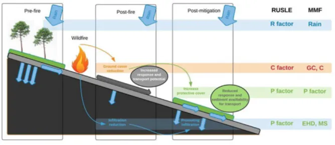
This study focuses on post-fire land management by mulching-based erosion mitigation measures, as their effectiveness in burnt areas is now well established to the point that they are now being applied on a routine basis in operational post-fire land management in the USA as well as Galicia. The compiled data set covered a range of different mulch materials (eucalypt forest residues, hydromulch, pine needles, pine chips, straw). As shown in Figure1, parameterization of both models (RUSLE, Renard et al., 1997; MMF, Morgan, 2001) explicitly addressed ground cover removal by fire and its reestablishment by mulching, post-fire reduction in infiltration as a result of (enhanced) soil water repellence (Keizer et al., 2008; Shakesby, 2011) was also explicitly addressed in both models but only for the seasonal predictions.
Figure 1: Post-fire runoff-erosion processes and their parameterization in the RUSLE and MMF models (adapted from Vieira et al., 2018).
13 Results
Table 1 gives an overview of the modeling results obtained by the previous studies on NW Spain and N Portugal. Overall, the calibration of RUSLE by Fernández et al. (2010) and Vieira et al. (2018) provided satisfactory modeling results, as both the NSE and R2 were above 0.5. Even so, Vieira et al. (2018) noted a tendency for annual sediment losses to be underestimated for the untreated plots and to be overestimated for the mulched plots. MMF appeared to perform similarly well as RUSLE in Fernandez et al. (2010) but somewhat better than RUSLE in Vieira et al. (2018). In Vieira et al., (2018), MMF allowed a clear distinction between untreated and mulched plots, independent of the type of mulch used, and its calibration (Calibration 6) was accurately validated at higher scale (Validation 6a), as well in other locations (Validation 6b).
Modelling efforts with the compiled data set are still ongoing but the preliminary results suggested that model performance is reduced by using a standardised model parameterization across the study region. This reduction is most noticeable for sites with high soil losses, for example in case of elevated soil burnt severity.
Table 1: Model efficiency obtained in prior studies for predicting post-fire soil erosion for different land uses. Nash-Sutcliffe efficiency coefficient - NSE, coefficient of determination - R2, Root mean square error – RMSE, percent of bias – PBIAS.
Land use Models time-step Calibration or Validation Location Size (m2) NSE R 2 PBIAS RMS E Publication Pine and Shrub-land
RUSLE annual Calibration 1
Verín and Soutelo, Spain 500 0.87 - - 6.3 Fernández et al., 2010 MMF annual Calibration 2 Verín and Soutelo, Spain 500 0.74 - - 9 Pine and Euca-lypt MMF annual Calibration 3 Pessegueiro do Vouga, Portugal 16 0.55 - - Vieira et al., 2014 MMF seasonal Calibration 4 Pessegueiro do Vouga, Portugal 16 0.89 - - 0.9
MMF annual Validation 4 Caramulo,
Portugal 16 0.93 - - 0.12
Pine RUSLE annual Calibration 5 Colmeal,
Portugal 0.5 0.63 0.75 -11.7 1.06
Vieira et
14 RUSLE annual Validation 5 Colmeal,
Portugal 10 0.70 0.89 -20.1 1.62
MMF annual Calibration 6 Colmeal,
Portugal 0.5 0.97 0.98 5.2 0.3
MMF annual Validation 6a Colmeal,
Portugal 10 0.77 0.79 1.9 1.43 MMF 3 months Validation 6b Loriga, Portugal 16 0.70 0.80 5.5 1.2 Un-published Discussion
Although RUSLE and MMF differ in underlying concepts, both models seem reasonably suitable to estimate soil losses following wildfire as well as mulch-based erosion mitigation measures. In support of operational post-fire land management, RUSLE would seem most suited for a “quick&dirty” identification of burnt areas with elevated erosion risk that are upstream of relevant values-at-risk. In a second phase, MMF could be applied to these priority areas, to assess the connectivity between hillslopes and the streams with the relevant downstream values-at-risk. In a third phase, MMF could be then used to elaborate and test plans for post-fire interventions.
Conclusions
Comparison of existing studies using RUSLE and MMF to model post-fire erosion in the western Iberian Peninsula as well as initial RUSLE and MMF results for a comprehensive, multi-site field data set across this same region indicated as main conclusions that:
1. both models can give satisfactory predictions of soil losses for recently burnt areas, including following mulching in order to reduce erosion risk;
2. both models can be calibrated using field data from small erosion plots (<1 m2) to obtain satisfactory predictions for substantially larger plots (10 m2);
3. a comprehensive assessment of both models for burnt areas still require substantial additional efforts, including through field monitoring of emergency stabilization measures applied in operational settings;
4. assessing soil burn severity and predicting post-fire vegetation recovery are two key challenges for accurately predicting post-fire erosion with both models.
Acknowledgements
This work was developed in the framework of the Interreg Sudoe Program (SOE2/P5/E0811) and FEMME project (PCIF/MPG/0019/2017) within the SR&TD Forest Fire Prevention and Fighting program.
Thanks are due for the financial support from FCT – Fundação para a Ciência e a Tecnologia, I.P. to CESAM (UID /AMB/50017 - POCI-01-0145-FEDER-007638), and MARETEC (UID/EEA/50009/2019), to FCT/MCTES
15 through national funds (PIDDAC), and the co-funding by the FEDER, within the PT2020 Partnership Agreement and Compete 2020.
We also acknowledge the funding of Vieira D. and Serpa D. by national funds (OE), through FCT – Fundação para a Ciência e a Tecnologia, I.P., in the scope of the framework contract foreseen in the numbers 4, 5 and 6 of the article 23, of the Decree-Law 57/2016, of August 29, changed by Law 57/2017, of July 19. The funding of Lopes A. was provided by the WAFLE project (POCI-01-0145-FEDER-031573). T. B. Ramos was supported by the FCT grant SFRH/BPD/110655/2015. Keizer J. also acknowledge his IF-FCT research grant (IF/01465/2015).
The views expressed in this information product are those of the author(s) and do not necessarily reflect the views or policies of FAO.
References
Burjachs, F. & Expósito, I. 2015. Charcoal and pollen analysis: Examples of Holocene fire dynamics in Mediterranean Iberian Peninsula. Catena, 135: 340-349.
Carvalho-Santos, C., Nunes, J.P., Monteiro, A.T., Hein, L. & Honrado, J.P. 2016. Assessing the effects of land cover and future climate conditions on the provision of hydrological services in a medium-sized watershed of Portugal. Hydrol. Process., 30: 720–738.
Fernández, C. & Vega, J.A. 2016. Evaluation of RUSLE and PESERA models for predicting soil erosion losses in the first year after wildfire in NW Spain. Geoderma, 273: 64-72. https://doi.org/10.1016/j.geoderma.2016.03.016.
Fernández, C., Veja, J.A. & Vieira, D.C.S. 2010. Assessing soil erosion after fire and rehabilitation treatments in NW Spain: performance of RUSLE and revised Morgan–Morgan–Finney models." Land Degrad. Develop., 21(1): 58-67.
Keizer, J.J., Doerr, S.H., Malvar, M.C., Prats, S.A., Ferreira, R.S.V., Oñate, M.G., Coelho, C.O.A. & Ferreira, A.J.D. 2008. Temporal variation in topsoil water repellency in two recently burnt eucalypt stands in north-central Portugal. Catena, 74: 192-204.
Larsen, I.J. & MacDonald, L.H. 2007. Predicting postfire sediment yields at the hillslope scale: Testing RUSLE and Disturbed WEPP. Water Resources Research, 43(11).
Moody, J.A., Shakesby, R.A., Robichaud, P.R., Cannon, S.H. & Martin, D.A. 2013. Current research issues related to post-wildfire runoff and erosion processes. Earth-Science Reviews, 122: 10–37.
Morgan, R.P.C. 2001. A simple approach to soil loss prediction: A revised Morgan–Morgan–Finney model.
Catena, 44: 305–322.
Nunes, J.P., Naranjo Quintanilla, P., Santos, J.M., Serpa, D., Carvalho-Santos, C., Rocha, J., Keizer, J.J. & Keesstra, S.D. 2018. Afforestation, Subsequent Forest Fires and Provision of Hydrological Services: A Model-Based Analysis for a Mediterranean Mountainous Catchment. Land Degrad. Develop., 29: 776 -788.
16 Renard, K.G., Foster, G.R., Weesies, G.A., McCool, D.K. & Yoder, D.C. (co-ordinators). 1997. Predicting soil erosion by water: A guide to conservation planning with the revised universal soil loss equation (RUSLE). Agriculture Handbook n- 703. USDA, Natural Resources Conservation Service: Washington, DC.
Robichaud, P.R. & Ashmun, L.E. 2012. Tools to aid post-wildfire assessment and erosion-mitigation treatment decisions. International Journal of Wildland Fire, 22: 95–105.
San-Miguel-Ayanz, J., Durrant, T., Boca, R., Libertà, G., Branco, A., de Rigo, D., Ferrari, D., Maianti, P., Vivancos, T.A., Schulte, E. & Loffler, P. 2017. Forest Fires in Europe, Middle East and North Africa 2016. EUR 28707 EN, Publications Office, Luxembourg, 2017, ISBN 978-92-79-71292-0.
Shakesby, R.A. 2011. Post-wildfire soil erosion in the Mediterranean: Review and future research directions.
Earth-Science Reviews, 105: 71–100.
Shakesby, R.A., Moody, J.A., Martin, D.A. & Robichaud, P.R. 2016. Synthesising empirical results to improve predictions of post-wildfire runoff and erosion response. International Journal of Wildland Fire, 25: 257– 261.
Turco, M., Bedia, J., Di Liberto, F., Fiorucci, P., von Hardenberg, J., Koutsias, N., Llasat, M., Xystrakis, F. & Provenzale, A. 2016. Decreasing Fires in Mediterranean Europe. PLoS ONE, 11(3): e0150663.
Vieira, D.C.S., Prats, S.A., Nunes, J.P., Shakesby, R.A., Coelho, C.O.A. & Keizer, J.J. 2014. Modelling runoff and erosion, and their mitigation, in burned Portuguese forest using the revised Morgan-Morgan-Finney model. Forest Ecology and Management, 314:150-165.
Vieira, D.C.S., Serpa, D., Nunes, J.P.C., Prats, S.A., Neves, R. & Keizer, J.J. 2018. Predicting the effectiveness of different mulching techniques in reducing post-fire runoff and erosion at plot scale with the RUSLE, MMF and PESERA models. Environmental Research, 165: 365-378.
17
Theme 1: Soil erosion assessment tools and data; creation, consolidation
and harmonization
Badland and gully erosion assessment using remotely sensed data, non-invasive field
techniques and stochastic modelling approaches
Michael Maerker*, Alberto Bosino, Alice Bernini
Department of Earth and Environmental Sciences, University of Pavia, Italy
Annika Cüppers
Department of Geography, University of Tübingen, Germany
Ulrike Hardenbicker
Department of Geography & environmental studies, University of Regina, Canada
Abstract
Badlands and gullies are a typical erosional landform occurring prevailingly in semiarid to sub-humid areas. Badland and gully formation processes are driven by i) natural settings, like highly erodible soils and substrates, intensive precipitation and/or scarce vegetation cover and by ii) human activity such as climate change or land use change. In this study we present an assessment of different badland and gully erosion areas in Italy, Canada and Southern Africa. Therefore, we applied innovative detection methods based on aerial photo interpretation and satellite remote sensing applications to derive detailed inventories. Moreover, we show how driving factors can be assessed using stochastic modelling approaches, multispectral satellite data and high-resolution global DEM information. The information about driving factors and environmental settings finally allows a spatial assessment of badland and gully erosion susceptibilities.
Keywords: Badlands, gully erosion, stochastic modelling, multispectral data, Terrain Analysis
Introduction, scope and main objectives
Semiarid to sub-humid climates such as the Mediterranean regions, are more and more affected by the interacting pressures of climatic and anthropogenic environmental changes, driving the environmental systems towards almost irreversible modifications (Scheffer et al., 2001; Märker et al., 2011). Several studies analysed the wide-ranging consequences of these changes in terms of land degradation and erosion processes and the issues they raise for land management (Wainwright and Thornes, 2003). Moreover, the socio-economic context is rapidly changing. In this context Badlands and gully areas are highly-erosive landscapes that are characterized by severe degradation processes. Badlands as well as gullies are considered as areas endangering agricultural activities though they have important ecological functions and are often hotspots of biodiversity.
There is a long history in studying i) the factors influencing the soil erosion processes and the resulting forms, ii) the dynamics of soil erosion processes, and iii) the spatial and temporal scales covered by these processes (e.g. Alexander, 1980; Clarke and Rendell, 2000; Capolongo et al., 2008). However, studies are often
18 conducted at the plot scale and only little work has been done on sub-catchment or catchment scale. Especially for the assessment of soil erosion processes and related sediment transport it is essential to know at which locations in the catchment what kind of process is active or might become active. Thus, methods were proposed that use relevant environmental and socioeconomic information to determine the disposition to specific erosion processes (e.g. Märker et al., 2011).
In this study we present an integrated approach that applies innovative detection methods based on aerial photo interpretation and satellite remote sensing to derive detailed badland and gully erosion inventories. Moreover, we show how driving factors can be assessed using stochastic modelling approaches, multispectral satellite data and high-resolution global DEM information. The information about driving factors and environmental settings finally allows a spatial assessment of badland and gully erosion susceptibilities.
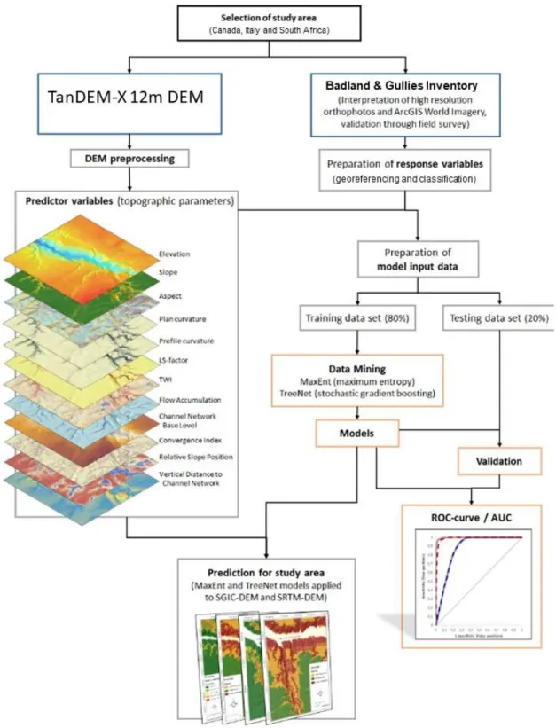
Methodology
The characterisation of badlands and gully systems in the three study areas followed a common systematic approach that consists in different steps illustrated by the flow chart (Figure 1) and described below.
Identification of forms and features
Badlands and gully systems were identified and mapped through field observations as well as Orthophotos, Google Earth and UAV based image interpretation (Zakerinejad & Märker 2014; Flügel & Märker 2002). Subsequently, a morphological classification of badland areas and gully systems’ forms and features was performed based on the remotely sensed information and their interpretation, following specific classifications like the ones developed by Moretti and Rodolfi (2000) or Van Zuidam (1989). Finally, an inventory map of the study area or of a smaller characteristic sub catchment can be generated and used as dependent or target variable in the stochastic modelling approach.
Derivation of environmental predictors
The morphometric factors (Slope, Aspect and General Curvature etc.) were automatically derived from a digital elevation model (DEM). In this study we used TerraSAR-X with 30m resolution, TanDEM-X DEM with 12.5 m cell size and a local Canadian model (SGIC) with 15 m resolution. The DTMs were hydrologically corrected to eliminate sinks. The DEM derivatives as well as additional information such as landuse maps or lithology/geology maps, soil maps were used as environmental predictor or independent variable.
Stochastic modelling approaches
In order to get information on the triggering factors and the spatio-temporal distribution of the badland forms and gully systems data mining techniques can be applied (e.g. Vorpahl et al., 2012). Common practices involve the use of stochastic and/or data mining methods relying on presence/absence techniques (e.g. Lombardo et al., 2014) for calibrating the predictive model. If classified target variables are used classification methods such as Boosted regression trees (e.g. Treenet) can be applied. If instead the target variable is consisting of only one class or one feature, presence-only approaches can be applied such as the Maximum Entropy (MaxEnt) (e.g. Phillips and Dudik, 2008; Park, 2014).
Model validation techniques
Normally, the dataset is split in a test and a train dataset for validation purposes (e.g. 75 % train data and 25 % test data). The model performance can be investigated by the the area under the receiver operating
19 characteristics curve (AUC), which represents true occurrence predictions as a function of false occurrence predictions (Swets, 1988). The area under this curve (AUC) theoretically ranges from 0 to 1. A random model would result in an AUC value of 0.5, while a perfect model discrimination leads to an AUC value of 1.
Figure 1: Flow chart of Methodological approach used in the three study areas in Canada, Italy and South Africa
20 Results
In the following we show preliminary results of analysis we conducted in Canada (Lake Diefenbaker), South Africa (Kwa Zulu Natal/ Mkomaazi basin) and Italy (Oltrepo Pavese).
In Figure 2 the distribution of badland areas in the Oltrepo Pavese is shown. The badlands have been classified according to Moretti and Rodolfi (2002) in two classes. This information is used then in the modelling phase as dependent or target variable. In the next step the independent variables or predictor variables were prepared. In the modeling procedure we use DEM derivatives such as illustrated in Figure 3a and b (Lake Diefenbaker, Canada), as well as additional information on landuse and substrates (soils, geology, lithology).
Figure 2: Badland (Calanchi) inventory of the Oltrepo Pavese (b) Example of Calanchi type A; (c) Example of Calanchi type B. (from Bosino et al. in press)
21 Figure 3a and b: Examples for predictor variables: a) LS-Factor b) Topographic Wetness Index
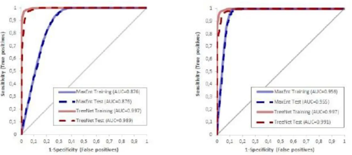
We conducted a detailed terrain analysis based on different DEMs with 12.5 m; 15 m and 30 m resolution. We separated the dataset in test and train data for model validation. In Figure 4 we illustrate some AUC plots of the Lake Diefenbaker area in Canada. Normally different methods are tested to assess model performance and robustness. Here, MaxEnt and a Treenet (Boosted Regression Trees) model are illustrated in Figure 4 with train and test data. As shown Boosted regression trees perform generally better. However, the models show a good robustness since all AUC values are above 0.8 (excellent performance) for both, test and train data sets. Moreover, also the variable importance can be assessed by the models.
22 Figure 4: AUC curves for badland areas in the Lake Diefenbaker, Canada. Different modelling approaches are reported for two different DEM resolutions. Left 15 m; Right 30 m resolution
Figure 5: Variable importance for 15m (left) and 30m DEM resolution (right) for MaxEnt (blue) and Treenet (red).
The variable importance reported in Figure 5 shows that the approach is consistent concerning the different models. However, some differences can be noted for the two DEM resolutions.
Discussion
The presented integrated method allows an assessment of badlands and gully forms and features. Aerial Photo Interpretation and/or Remote Sensing/UAV data interpretation together with fieldwork yield forms and processes inventories. Using environmental information on Landuse/Landcover, Geology, Lithology and Soil available through maps and digital data as well as DEMs, and DEM derivatives form terrain analysis we have valuable information to assess the processes driving forces. Therefore, we can apply stochastic modelling approaches that must be evaluated using train and test data in order to guarantee a proper model performance and robustness of the modelling results. As shown, one should test different spatial resolutions that are fitted to the respective process investigated. If the models are validated and calibrated successfully,
23 they yield also information about the potential spatial distribution (susceptibility) of the process’s forms and features.
Conclusions
The integrated method presented in this study was applied successful in three different semiarid to sub-humid environments. We were able to define and discriminate the forms and features related to badlands and gully erosion. Thus, we derived inventory data, that together with additional environmental information was stochastically assessed. The stochastic model applications yield valuable information about the process drivers as well as on the spatial distribution of process potentials, the so-called susceptibility. This is a major step forward in river catchment scale assessment of soil erosion processes. Once we know where processes might occur, we can apply coping and mitigating strategies to prevent soil loss.
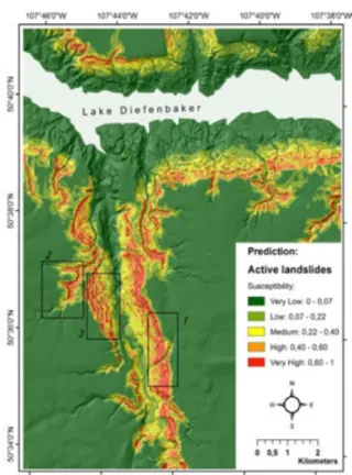
Figure 6: Spatial distribution of susceptibility of badlands and gullies showing active landslides using MaxEnt and the 15, SGIC DEM. Susceptibilities in %.
Acknowledgements
We would like to thank for financial support from Pavia University, Regina University and Tübingen University as well as DLR for providing the TanDEM-X DEM.
The views expressed in this information product are those of the author(s) and do not necessarily reflect the views or policies of FAO.