HAL Id: hal-02958327
https://hal.uca.fr/hal-02958327
Submitted on 10 Nov 2020
HAL is a multi-disciplinary open access archive for the deposit and dissemination of sci-entific research documents, whether they are pub-lished or not. The documents may come from teaching and research institutions in France or abroad, or from public or private research centers.
L’archive ouverte pluridisciplinaire HAL, est destinée au dépôt et à la diffusion de documents scientifiques de niveau recherche, publiés ou non, émanant des établissements d’enseignement et de recherche français ou étrangers, des laboratoires publics ou privés.
Real world–based immersive Virtual Reality for
research, teaching and communication in volcanology
A. Tibaldi, F. Bonali, F. Vitello, E. Delage, P. Nomikou, V. Antoniou, U.
Becciani, Benjamin van Wyk de Vries, M. Krokos, M. Whitworth
To cite this version:
A. Tibaldi, F. Bonali, F. Vitello, E. Delage, P. Nomikou, et al.. Real world–based immersive Virtual Reality for research, teaching and communication in volcanology. Bulletin of Volcanology, Springer Verlag, 2020, 82 (5), �10.1007/s00445-020-01376-6�. �hal-02958327�
Bulletin of Volcanology
Real world-based immersive Virtual Reality for research, teaching and communication
in volcanology
--Manuscript
Draft--Manuscript Number: BUVO-D-19-00117R2
Full Title: Real world-based immersive Virtual Reality for research, teaching and communication in volcanology
Article Type: Short Scientific Communication Corresponding Author: Alessandro Tibaldi, Ph.D., Msc
University of Milan Bicocca Milan, ITALY
Corresponding Author Secondary Information:
Order of Authors: Alessandro Tibaldi, Ph.D., Msc F.L. Bonali Fabio Vitello Emanuel Delage Pareskevi Nomikou Varvara Antoniou Ugo Becciani
Benjamin Van Wyk de Vries Mel Krokos
Malcolm Whitworth
Funding Information: Erasmus+ Not applicable
Ministero dell’Istruzione, dell’Università e
della Ricerca Prof. Alessandro Tibaldi
Abstract: Direct outcrop observation and field data collection are key techniques in research, teaching and outreach activities in volcanic areas. However, very often outcrops are of difficult or inaccessible access, such as in areas with active volcanoes or steep cliffs. Classical remote-sensing surveys by satellites or airplanes are expensive, rarely reach sufficient resolution to allow high quality 3D visualisation of volcanic features, and do not facilitate mapping of vertical cliffs. We describe a novel approach that uses the immersive Virtual Reality (VR) based on real world 3D Digital Outcrop Models (DOMs) from images surveyed by unmanned aerial vehicles (UAV). 3D DOMs are built up using the Structure from Motion (SfM) photogrammetry technique, and a Virtual Reality scene is created using game engine technologies. Immersive real-time exploration of the environment is possible through a head mounted display, e.g. Oculus Rift. Tools embedded in the VR environment allow the user to map polygons, lines, point features, measure orientation, dip, inclination, azimuth, area, thickness and even take virtual photographs. Using three examples of volcanic areas with different geological features, we demonstrate the potential of our approach to allow users to be able to virtually map and measure remotely, and to collect data for research and teaching. Our approach is of paramount importance also for outreach, as it allows non-specialist audiences (e.g. common citizens) to experience and appreciate highly complex volcanic features through customised, hands-on immersive VR tools.
Response to Reviewers: I have corrected the paper and figures as suggested by the Editor Taddeucci. Author Comments: As suggested by the Editor Taddeucci, I added three videos related to the paper as
Supplementary material, and a pdf containing the video captions (a very brief description).
1
Real world-based immersive Virtual Reality for research, teaching
1
and communication in volcanology
2 3
Tibaldi A.1, Bonali F.L.1, Vitello F.2, Delage E.3, Nomikou P.4, Antoniou V.4, Becciani U.2, VanWyk de
4
Vries B.3, Krokos M.5, Whitworth M.6
5 6
1 Department of Earth and Environmental Sciences, University of Milan Bicocca, Italy
7
2 National Institute of Astrophysics, Catania, Italy
8
3 Observatoire du Physique du Globe de Clermont, University Clermont Auvergne, Clermont- Ferrand,
9
France
10
4 Faculty of Geology and Geoenvironment, National and Kapodistrian University of Athens, Greece
11
5 School of Creative Technologies, University of Portsmouth, UK
12
6 School of the Environment, Geography and Geosciences, University of Portsmouth, UK
13 14 15
Abstract
16
Direct outcrop observation and field data collection are key techniques in research, teaching and outreach
17
activities in volcanic areas. However, very often outcrops are of difficult or impossible access, such as in areas
18
with active volcanoes or steep cliffs. Classical remote-sensing surveys by satellites or airplanes are expensive,
19
rarely reach sufficient resolution to allow high quality 3D visualisation of volcanic features, and do not
20
facilitate mapping of vertical cliffs. We describe a novel approach that uses immersive Virtual Reality (VR)
21
based on real world 3D Digital Outcrop Models (DOMs) from images surveyed by “unoccupied aerial system"
22
(UAS). 3D DOMs are built up using the Structure-from-Motion (SfM) photogrammetry technique, and a VR
23
scene is created using game engine technologies. Immersive real-time exploration of the environment is
24
possible through a head-mounted display, e.g. Oculus Rift. Tools embedded in the VR environment allow the
25
user to map polygons, lines and point features. Tools also allow to measure orientation, dip, inclination,
26
azimuth, area, thickness and even take virtual photographs. Using three examples of volcanic areas with
27
different geological features, we demonstrate the potential of our approach to allow users to be able to virtually
28
map and measure remotely, and to collect data for research and teaching. Our approach is of paramount
29
importance also for outreach, as it allows non-specialist audiences (e.g. common citizens) to experience and
30
appreciate highly complex volcanic features through customised, hands-on immersive VR tools.
31 32
Key words: Volcanology, Teaching & Scientific Communication, Immersive Virtual Reality,
Head-33 Mounted Displays 34 35 Introduction 36
Research activity, teaching and learning in volcanological sciences need the collection and observation of data
37
in the field, which typically constitute the backbone of any applied study in petrography, geochemistry,
38
geohazard, and many other areas. Outcrops can often be difficult to access for logistical reasons, or even
39
impossible to inspect, e.g. in the case of steep or vertical cliffs. Data collection can also be dangerous, as in
40
active volcanic areas with explosions, gas, hot fumes, etc., or other areas prone to geological hazards. Also,
41
teaching and learning is classically based on 2D images, although geological objects are 3D; to overcome this
42
Man scrip Click here to access/do nload;Man script;IJAEOG_25 3 2020
no track changes.doc Click here to ie linked References
problem, university geoscience courses typically include extensive fieldwork programmes, but these involve
43
expensive and time-consuming trips.
44
In the case of extra-university communication addressing audiences within the society at large, including
45
administrators, politicians, media and individual citizens, immersive Virtual Reality (VR) can allow different
46
target groups to experience volcanic features in inclusive and novel (or otherwise impossible) ways. The term
47
immersive VR refers to the perception of being physically present in a non-physical world. The perception is
48
obtained by surrounding the user with images, sound or other stimuli, providing the feeling of being immersed
49
in the environment. In Earth Sciences, this is essentially achieved by surrounding images (Granshaw and
50
Duggan-Haas, 2012; Trexler et al., 2018; Zhao et al., 2019). As immersive VR can be fun, and different, it
51
also engages people and allows them to express their thoughts and feeling about natural sites. This results in
52
outreach and embracing communication, a two-way process that can help scientists understand the needs and
53
opinions of society. Moreover, game engines have reached a high level of technological maturity offering rich
54
toolsets of mechanisms for implementing 2D/3D visualisation and exploration workflows in immersive VR
55
environments realised on dedicated game consoles, personal computers or mobile platforms (Andrade, 2015;
56
Lawson, 2016; Christopoulou and Xinogalos, 2017).
57
Remote or dangerous volcanic areas have been classically studied by aerial or satellite remotely-sensed images,
58
which have several limitations: 1) high-resolution data are very expensive to cover large-scale geological
59
objects and the resolution can be poor for some targets, 2) it can be challenging to plan a specific survey by an
60
airplane, due to high costs or remoteness of the site, 3) it is impossible to map steep to vertical slopes by images
61
acquired in vertical nadir, and 4) images are mostly 2D. Recently, unoccupied aerial systems (UASs), due to
62
their high imaging capabilities, have been used to study volcanic eruption sites (Müller et al., 2017), dykes
63
(Dering et al., 2019), volcano-tectonic relations (Walter et al., 2018; Bonali et al., 2019) and active faults in
64
volcanic areas (Rust and Whitworth, 2019), as well as faults and landslides in non-volcanic environment
65
(Rathje and Franke, 2016; Gao et al., 2017). UASs are also known as drones, aerial photography systems and
66
unmanned aerial vehicles. Recently, some studies have used the Structure from Motion (SfM) technique to
67
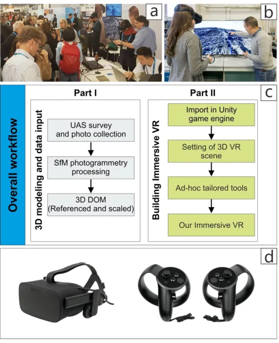
create 3D Digital Outcrop Models (DOMs) of UAS-mapped areas (Benassi et al., 2017; Burns and Delparte,
68
2017; Cook, 2017; Pavlis and Mason, 2017), but none of these approaches has fully exploited the 3D nature
69
of the modelled structures to allow the user to interact with the full 3D geometry of the model for measurement
70
and mapping purposes. An attempt in this sense has been done by Gonzaga et al. (2017), although their
71
approach is just focused on single, limited outcrops.
72
Here we present an approach that allows a more complete understanding of volcanic features for teaching,
73
learning and research, using immersive VR based on real world 3D DOMs scenario. Our approach, in fact,
74
establishes a framework that provides a unique blend of tools allowing: i) the study of geological or
75
volcanological sites at a wide range of scales, from small outcrops to large areas, ii) wide range of
76
measurements, and iii) wide range of exploration scenarios. Using three examples of volcanic areas with
77
different features, we demonstrate the potential of this type of approach to optimize the users’ geological
78
experience by allowing them to move around outcrops and take quantitative measurements. Furthermore, this
3
allows far more embracing contact and exchange with a wider audience; we started to present our immersive
80
VR at schools, national and international exhibitions (e.g. Fig. 1a) open days, and with the public in all sorts
81
of situations, provoking very positive feedbacks and popularizing volcanological sciences and geological
82
features of volcanic areas. We also used the feedback from students and colleagues to improve our software
83
and tools.
84 85
3D modelling and data input (Part I)
86
Our approach consists of creating immersive VR that provides scientists and students with virtual ways to
87
study rock outcrops and collect measurements (e.g. Fig. 1b), replicating classical field activity. The first step
88
consists of creating a high-resolution 3D DOM, which is based off a real world scene, with UAS surveys
89
planned at a scale suitable for the research purposes and using the SfM workflow (e.g. James and Robson,
90
2014; James et al., 2017; Bonali et al., 2019). We would like to remark that 3D DOM can be also referred as
91
“Virtual Outcrops (VO)” (Xu et al., 1999; Tavani et al., 2014) that, with our approach, can be studied in first
92
person. A Wavefront Object File (OBJ) - in the form of a Tiled model - was selected to store the 3D geometry
93
and texture, based on the UAS-collected high-resolution images, as it can be easily imported and managed in
94
the Unity game engine (Unity is a cross-platform game engine developed by Unity Technologies, and a game
95
engine is a software-development environment designed for people to build video games) (Krokos et al., 2019).
96
The resolution and accuracy of the resulting model depends on the UAS camera resolution, UAS distance to
97
target during photo acquisition, number of established ground control points and level of quality during SfM
98
processing (details in Westboy et al., 2012; Bonali et al., 2019). For example, when flying about 25 m above
99
the target, we achieve a resolution of 8 mm/pixel, as shown in our example of the Greek Metaxa mine that will
100
be described below. All surveys in the present work have been done using a quadcopter equipped with a 20
101
MPX camera, including EXIF (Exchangeable Image file Format) information and GPS coordinates, provided
102
by the integrated Satellite Positioning Systems GPS/GLONASS (referred to the WGS84 datum). Thanks to a
103
built-in high precision 3-axis gimbal, flights are smooth, and the image collection is steady. The model we
104
used provides constantly stable flights thanks to the integrated GPS system, including position holding, altitude
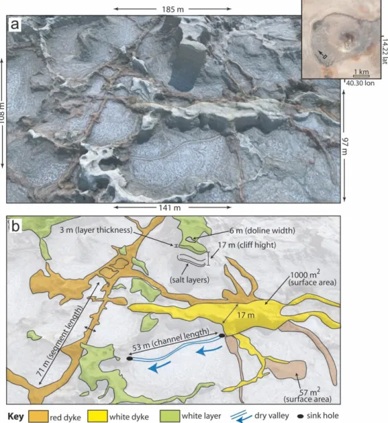
105
lock and stable hovering. Hereunder we summarise the overall steps to produce a high-resolution 3D DOM
106
(Part I of the overall workflow shown in Figure 1c).
107
The first step is to define the area to be surveyed, the UAS flight missions, including paths orientations and
108
flight height, that can be planned and managed using dedicated software, particularly for pictures acquired in
109
nadir orientation. The UAS has been manually driven to collect pictures with oblique orientation of the camera
110
and to detail vertical cliffs. Photo overlap has also to be defined, as suggested by Gerloni et al. (2018), Bonali
111
et al. (2019), Krokos et al. (2019) and Antoniou et al. (2019). In fact, it is recommended that UAS-captured
112
photos should have an overlap of 90% along the path and 80% in lateral direction, in order to obtain a greater
113
alignment of images and to reduce the distortions on the resulting texture. The photos have been captured every
114
2 seconds (equal time interval mode), with a constant velocity of 3 m/s (low speed) and in optimal light
115
conditions suitable for the camera ISO range (100-1600) (Bonali et al., 2019).
In order to allow for the co-registration of datasets and the calibration of models resulting from SfM processing
117
(e.g. Orthomosaics and DSMs), World Geodetic System (WGS84) coordinates of, at least, four artificial
118
Ground Control Points (GCPs) must be established near each corner within each surveyed area and one in the
119
central part (e.g. James and Robson, 2012; Turner et al., 2012; Westoby et al., 2012; James et al., 2017) for
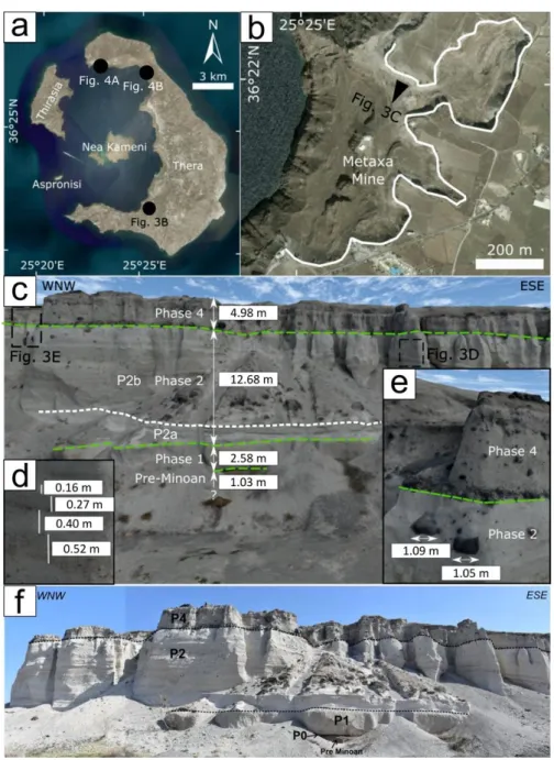
120
reducing the ‘doming’ effect resulting from SfM processing. Wherever possible, GCPs were surveyed with the
121
Emlid Reach RS©, low-cost single frequency receivers (Rover and Base) in RTK configuration (with
122
centimetre-level accuracy), finally correcting the z (altitude above the sea level ) values of the GCPs using the
123
regional geoid model to obtain the orthometric height for the models.
124
Focusing on data processing aimed at 3D DOM production, photos have been processed with the use of Agisoft
125
Metashape (http://www.agisoft.com/). This is a SfM software becoming increasingly widely used in the
126
geological community for both UAS and field based SfM studies for its user-friendly interface, intuitive
127
workflow and high quality of points clouds (Benassi et al., 2017; Burns et al., 2017; Cook, 2017). The SfM
128
technique allowed to identify matching features in different photos, collected along a defined flight path (Fig.
129
5b), and combined them to create a sparse and dense cloud, and the Wavefront OBJ Tiled model (further
130
details in Stal et al., 2012; Westoby et al., 2012). The first step was to obtain an initial low-quality photo
131
alignment, only considering measured camera locations (Reference preselection mode). After that, photos with
132
quality value 0.5, or out of focus, were excluded from further photogrammetric processing, following the
133
software user manual (Agisoft LLC, 2018). The focal length and photo dimensions were automatically detected
134
by the software, after the import of digital images and then used for the subsequent calibration of the intrinsic
135
parameters of the camera (principal point coordinates, distortion coefficients). After this first quality check,
136
we added Ground Control Points (GCPs) in all photos, where available, in order to: i) scale and georeference
137
the point cloud (and thus the resulting model); ii) optimize extrinsic parameters, such as estimated camera
138
locations and orientations; iii) improve the accuracy of the final model. We then realigned the photos using
139
high accuracy settings: as a result of this step, camera location and orientation were better established, and the
140
sparse point cloud was computed by the software. The next step consisted in reconstructing the dense point
141
cloud, calculated from the sparse point cloud, using a Mild depth filtering and medium/high quality settings.
142
The 3D tiled model was then reconstructed using the dense cloud as source data for a Medium number of Face
143
count and exported in the format OBJ tiled model. The information provided with the OBJ Tiled Model must
144
be imported in the Unity game engine in order to replicate a real-world reference system.
145 146 147 148
5 149 150
Figure 1. a) International outreach event using immersive VR in the framework of the the EGU General
151
Assembly 2019; b) Example of teacher and student activity using immersive VR.; c) Processing workflow
152
overview; d) VR headset on the left and sticks used to interact with the scene, on the right.
153 154 155
Building Immersive VR (Part II)
156
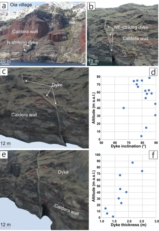
The target of our approach is to comprehensively simulate field experiences and observational behaviours of
157
geoscientists using high-resolution datasets and models. Our approach provides interaction experiences
158
realising navigation/exploration workflows that may not even be possible in the actual field, thus giving unique
159
spatial awareness insights in comprehending complex volcanological processes. An example can be the
160
monitoring of a steep slope on an active volcano, where uprising magma, intrusions, or earthquake shaking
161
can destabilise the slope with the possibility of slope failure. These multiple hazards create a complex scenario
162
that requires field inspection and collection of reliable field measures, but this can be impossible for the
163
impending threats.
We developed a software that provides end users with a holistic view of an area of interest, by allowing
165
exploration of specific features from several points of view and at a range of different scales (see supplemental
166
videos 1, 2 and 3), starting from technologies commonly used in entertainment applications (such as video
167
games). Those include modern game engines (Unity, https://unity.com) combined with Virtual Reality devices
168
(Oculus Rift, https://www.oculus.com/). Unity supports modularity and extensibility to build modular assets
169
that are easily expanded and sustained long term. Furthermore, Unity supports several file formats as used in
170
industry-leading 3D applications (e.g. 3DS Max, Blender). Unity is also well documented as it is supported by
171
large numbers of communities of software developers. Although the development of our software framework
172
is based on the Unity game engine and Oculus, we have deployed generic functionalities of game engines and
173
head mounted displays abstracting as much as possible from specific realisations.
174
Our system supports a high-performance visualisation layer underpinning a comprehensive set of navigation,
175
interaction and accurate measurement tools to allow geoscientists full appreciation of on-shore settings. Unlike
176
other software for handling digital outcrops (VRGS, www.vrgeoscience.com, or MOSIS of Gonzaga et al.,
177
2017), our focus has been on developing a fully integrated software suite for seamless VR navigation of wide
178
areas. Moreover, our software enables, via appropriate controls, rich user interactions and on-the-fly
179
visualisation adjustments. The uniqueness of our framework lies on the modularity of its underlying
180
architecture enabling support for multiple mechanisms to select and deploy navigation approaches. It enables
181
incorporation of several import and export mechanisms to ensure the creation of data products with long-term
182
sustainability. The 3D DOM/Tiled model approach is built upon UAS-based SfM techniques and is thus able
183
to provide centimetric pixel size resolution for textures. The use of Wavefront OBJ Tiled model was
184
successfully designed and tested by Krokos et al. (2019) who applied it to areas of different extents and
185
resolutions, respectively ranging 50-1000 m (along the longest) and 0.8-4 cm, also considering the present
186
work. The use of 3D DOM allows improved representations of geometrical features especially around regions
187
that are vertical to the terrain.
188
Starting from the processed datasets (see Part I), the user must perform few preliminary operations in order to
189
make the scene navigable: an invisible object called “collider” must be assigned to each mesh for the purposes
190
of physical collisions, and the scene has to be properly referenced and scaled by employing information derived
191
from SfM processing. Thus, the scene dimension (in meters) and the corresponding geographic coordinates
192
must be defined, as well as the altitude referred to the 3D reconstructed model. All informations are included
193
in the Tiled Model folder, in Wavefront OBJ format, provided by SfM software we used. Finally, to optimize
194
the rendering performance of the scene, we also suggest the use of Unity Levels of Detail (LODs) methodology
195
to reduce the number of details shown when the model is far away from the camera. For this case, in the Tiled
196
Model folder different level of details for the model that can be set up in Unity engine are already provided.
197
First of all, the user will see the scenario in first person and walk on a “solid ground surface” to allow them to
198
move around within the virtual scene, or the user can fly over the area, allowing him to have a different view
199
of the outcrop that may open perspectives that are not possible to experience during real fieldwork (see
200
supplemental video 1).
7
Our software also includes a series of tools embedded in the VR environment, represented by symbols that
202
appear on the screen by pressing a button of the joystick (Fig. 1d) (see supplemental video 2). Such tools have
203
been developed by our research team that comprises also software developers and required some months of
204
work in strict collaboration with geologists. The tools were in fact customized on the classical needs of
205
geologists and volcanologists in the field, which are of paramount importance to quantitatively describe the
206
features of a given area. Directly on the screen you can choose the tool you need. The tools have been
207
developed with the idea of allowing the user to take measurements like being in the field, but with the
208
advantage that the user can change the angle of view in order to better select the proper perspective to take
209
measures. Once you have selected the tool, you point with the joystick the object to be analysed. A tool allows
210
to assess geographic location by coordinates. Another tool allows to select a point feature. By other tools it is
211
possible to map polygons and lines, and measure areas. In these cases, it is necessary to click with the joystick
212
in different points on the virtual ground. Other tools allow the measurement of dip, inclination, and azimuth
213
of an object. By clicking on two points with another tool, it is possible to measure thickness of volcanological
214
objects such as bedding, dykes, etc, and with another tool it is possible to reconstruct the topographic profile.
215
Finally, the system allows to take virtual photographs and notes.
216 217
Case studies
218
The Dallol Volcano, Ethiopia
219
The active Dallol Volcano was one of the most inaccessible places on Earth, but recently has opened up due
220
to a new road, and there is rapid increase of tourists visiting the incredible geothermal manifestations. This has
221
led to increased risk from multiple geohazards and from the extreme climate. Assessing hazards requires
222
detailed topographic and geologic information, but the area is dangerous and hard to access. Thus, the area
223
was surveyed by UAS and data was processed following our approach (Fig. 2a). Particularly, the 3D DOM is
224
based on 229 pictures acquired with nadir camera orientation, at a flight height of 113 m, obtaining a texture
225
resolution of 2.87 cm/pixel over an area of 0.176 km². Photo alignment has been processed with high quality
226
setting and using Generic and Reference preselection. The dense cloud has also been built up using high
227
quality, whereas GCPs have been not collected in the field due to hard logistic condition. In the VR
228
environment, we have been able to access areas impossible in the field, making measurements and observing
229
features. We have detected different types of dykes and found erupted products (Fig. 2b). We have also
230
characterized and quantified salt karst structures, to start integrating measurements into a hydrogeological–
231
volcanological model. Tower morphologies are topped by a 3-m thick white eruption deposit. A tower of salt
232
layers has a vertical sided doline (sink hole) which is 6 m across, and at least 5 m deep, set on a flat area above
233
a 17-m high cliff. Dykes of red clay, possibly filled karst pathways, from Dallol’s central hydrothermal area,
234
are mapped and selected measurements shown. A white dyke, made of salt and magma is up to 17 m wide
235
outcropping over 1000 m2. A small dry river channel between source and sink holes is 53 m long.
236
This Dallol reconstruction has already been shown in Ethiopia and internationally, and has been used to get
237
opinions of stakeholders on the nature of the geological object, its use in geotourism and possibilities of
protection. Users who know the area, mostly geologists so far, have expressed amazement at the ability to see
239
the geological features that they have missed in the field. Prospective visitors (non geologists) have also
240
expressed amazement and wonder at being able to fly around such a landscape.
241 242
243 244
Figure 2. a) 3D representation of an area of the Dallol volcano (Ethiopia) captured using camera tool in
245
Immersive VR. (distances show the measured length of the edges of the perspective). Inset shows full view of
246
Dallol volcano and locates the area described, with arrow for view direction. b) Interpretation with some
247
examples of quantitative measurements taken in Immersive VR environment. Selected features mapped in this
248
area include red dykes related to infilling of the karst system, a white dyke magmatic–hydrothermal intrusion,
249
white eruptive layers, and sink holes.
250 251
The Metaxa mine, Greece
252
The Metaxa Mine is a unique geotope of Santorini volcano (Greece) where the pumice layers of the famous
253
Late Bronze Age (LBA) (well-known also as Minoan) eruption are exposed (see supplemental video 3). It is
254
nowadays abandoned and it is located in the central part of Santorini island, overlooking the famous Santorini
255
caldera (Figs. 3a, b). The latter was created after the catastrophic Minoan eruption (Friedrich et al., 2006;
256
Druitt, 2014), which has influenced the decline of the Minoan civilization on Crete, making it an iconic event
9
in both volcanology and archaeology disciplines. The mine contains the so-called “Famous section” which
258
shows the pumice layers of the eruption along a length of 150 m (see the pictures collected from our immersive
259
VR in Fig. 3c) and classical field activity (Fig. 3d). From the area which is located on the east side of the
260
Famous section, about 1.3 million m3 were excavated in the early years of mining. A total of 4.5 million m3 is
261
estimated to have been extracted from the Metaxa mine, according to 3D digital model of the terrain (Antoniou
262
et al., 2019). Our approach provides an excellent way to access the vertical and overhanging cliffs in immersive
263
VR and to analyse it in detail in a way that was not possible before. The resulting 3D DOM has a pixel
264
resolution of 8 mm and allows the recognition and measurement of the thickness not only of the main different
265
pyroclastic layers, but also of the single eruptive pulse events (Fig. 3d), and even the diameter (down to 1-2
266
cm) of the lithic clasts embedded in the vertical exposure (Fig. 3e). Pictures have been taken in two main
267
different missions: the first was devoted to capture a set of photos in nadir camera view (n=1121) to cover the
268
whole selected area; in the second we collected photos (n=992) of the vertical outcrops with the camera
269
oriented orthogonal to the vertical cliff, in order to add as much details as possible to the resulting model.
270
Photo alignment has been processed with high quality setting and both using Generic and Reference
271
preselection, the dense cloud has also been built up using medium quality, considering the extent and resolution
272
of the final model, and a set of 20 uniformly distributed Ground Control Points have been included in order to
273
co-register the 3D model to the World Geodetic System (WGS84) (Smith et al., 2016; Esposito et al., 2017).
274
The resulting 3D DOM is as large as 349 x 383 m.
275
In Figure 3c, we can distinguish: a) The 103-cm-thick Pre-Minoan base, b) a reverse-graded pumice fall deposit
276
of 258 cm thickness from the first main Plinian eruption (Phase 1, P1), c) the 731-cm-thick pyroclastic surge
277
deposits with multiple bedsets, dune-like bedforms with wavelengths of several meters or more and bomb sag
278
horizons (Phase 2, P2) (Bond and Sparks 1976; Heiken and McCoy, 1984; McClelland and Thomas,1990),
279
and d) within eruptive Phase 2, it is easy to distinguish the lowest fine-grained bedset (P2a) from the overlying
280
coarse grained sequence of multiple bedsets (P2b) and the 498-cm-thick fine-grained, nonwelded ignimbrite
281
(P4). The precursory explosion phase (P0) is characterized by a thin lapilli fallout layer of 10 cm in thickness,
282
shown in the field-panoramic view of the Famous section (Fig. 3f). These measures have been obtained by our
283
VR approach and similar detailed values did not exist for the site. At general, Phase 1 corresponds to a Plinian
284
eruption, whereas Phase 2 was characterized by syn-plinian pyroclastic surges. In Phase 3, eruption of ‘cold’
285
phreatomagmatic pyroclastic flows constructed a large tuff cone that filled the old caldera, cutting it off from
286
the sea. In Phase 4, eruption of hot pyroclastic flows took place from multiple subaerial vents, associated with
287
caldera collapse that enlarged and deepened the ancient caldera (Nomikou et al., 2016).
288
For science popularization and communication, the VR reconstruction of Metaxa mine is being used in a
289
UNESCO Geosciences Programme project (IGCP project 692 “Geoheritage for Geohazard Resilience”) to
290
raise awareness in the geological community and in the more general public about the value of this site, which
291
is in urgent need of protection and development as a unique heritage demonstration of the powerful volcanic
292
eruptions of Santorini. Moreover, this site has great value in regards to the relations between volcanic activity
293
and humans: this mine is part of Santorini history, especially in relation to the economic development of local
populations, who in difficult times were able to find income opportunities thanks to the extraction of pumice
295
materials. The Metaxa mine is not only a site of international scientific relevance, but also an industrial heritage
296
site that, as every monument, deserves special attention. The VR model has also been presented at Santorini
297
administrations in order to explain in a more effective way the features present in the field. Finally, in regards
298
to teaching, our VR model has been used to train Msc and PhD students of different European countries during
299
a series of International Summer Schools organized in the framework of the 2018-2020 project Erasmus+ KA2
300
“3DTeLC: Bringing the 3D-world into the classroom: a new approach to Teaching, Learning and
301
Communicating the science of geohazards in terrestrial and marine environments”.
302 303
304
Figure 3. Metaxa mine example: a) Location in Santorini island. b) Location of the reconstructed outcrop used
305
in this example. c) 3D view of the “Famous section” showing the main strata of the various Minoan eruptive
306
phases and measured thickness in immersive VR. d) and e) Examples of measurement of lithic clasts at vertical
307
outcrops by VR. f) Field-panoramic view of the “Famous section” (modified after Antoniou et al., 2019).
308 309 310
11 311
Outstanding dykes along the Santorini s caldera wall, Greece
312
Santorini is a unique place where it is possible to study outstanding feeder and non-feeder dykes (e.g. Figs.
4a-313
b), cropping out along the northern part of the caldera wall. Their study is of paramount importance for better
314
understanding processes related to the propagation paths of fractures/dykes through layers with dissimilar
315
mechanical properties, since they are emplaced in a highly heterogeneous and anisotropic host rock. Their
316
mapping could provide valuable insights on the topic. In fact, Browning et al. (2015) started this work
317
collecting detailed measurements of dykes at the sea level in some accessible sites. The problem is that most
318
dykes crop out along inaccessible vertical cliffs (up to 300 m high) or dangerous areas with hard logistic
319
conditions (continuous rockfalls), and thus their characterisation can only be done very locally, at the sea level,
320
and cannot be measured along their whole outcropping range. We give here an example to illustrate how it is
321
possible to overcome such difficulties. We also emphasize that this is just an example, but a full study of the
322
whole cliff is underway by VR and will be published in another paper. This represents measurements at a site
323
that was previously inaccessible. We reconstructed a text-book case of a dyke (Figs. 4c-e) using UAS-collected
324
pictures and SfM processing, obtaining a model with a texture resolution of 4 cm/pixel. Pictures have been
325
collected with oblique orientation of the camera using a quadcopter equipped with a 20 MPX camera. It has
326
been manually driven, at a constant velocity of 3 m/s and capturing pictures every 2 seconds (equal time
327
interval mode), flying between the sea level and a maximum height of 130 m. Regarding the processing, photo
328
alignment has been processed with high quality setting and both using Generic and Reference preselection.
329
The dense cloud has been built up using medium quality, and a set of 5 GCPs have been included in order to
330
co-register the 3D model to the World Geodetic System (WGS84) (Smith et al., 2016; Esposito et al., 2017).
331
The resulting 3D DOM is as large as about 1000 x 340 m.
332
Different from the two examples described before, in this case quantitative data have been collected flying in
333
front and around the dyke, instead of walking within the 3D DOM. Using the measurement tools, we collected
334
dyke inclination and thickness from the sea level up to an altitude of 100 m, providing unique and new data
335
(Figs. d-e). The selected dyke is characterised by a dip angle of about 80° at the sea level, with a NW dip,
336
becoming vertical between 30-50 m a.s.l. Between 50-90 m a.s.l., its inclination decreases to 70-80°. The
337
thickness is between 1.0-1.5 m from sea level to an altitude of 20 m, and increases up to 2-2.5 m at 80-90 m
338
a.s.l. These results demonstrate that the immersive VR we developed has a great potential to fully study the
339
dyke swarm emplaced in the Santorini volcano, as well as any other magma plumbing system exposed at
340
vertical cliffs. Even though field studies are vital for mapping and understanding the geological processes on
341
Earth, in several cases, like the one here shown, classical surveys are impossible, whereas our approach
342
represents a solution.
343 344
345
Figure 4. a) Boat-collected picture of a vertical dyke outcropping along the NW part of the caldera wall, in
346
correspondence of the Oia village; houses for scale, the location is provided in Figure 3a. b) UAS-collected
347
picture of a mostly vertical NE-striking dyke, outcropping in the NE part of the caldera wall, location is marked
348
in Figure 4a (picture courtesy of Luca Fallati). c) and e) show the same dyke of Figure 4b but the pictures have
349
been collected in immersive VR, as well as all measurements regarding dyke inclination and thickness
350
presented in figures d) and f).
351 352
Discussion
353
Volcanic areas are of high interest for scientific and economic reasons, such as minerals, soil fertility and
354
tourism. In the case of active volcanoes, they can pose significant threats to large populations and
355
infrastructures, and the latter can be temporarily or permanently interrupted with significant repercussions for
356
economic and social stability. Volcanic areas can also have spectacular features that attract the attention of the
13
wider public, who is keen to experience and know more about them, but that is also a risk if people go close
358
to hazardous sites. Therefore, the reconnaissance, mapping, quantification and understanding of volcanic areas
359
is increasingly important, together with the communication of volcanic hazards.
360
To date, the study of volcanic areas has relied largely upon standard field data collection techniques, but these
361
can be affected by logistic and time constraints or difficulties in accessing dangerous sites. For example, an
362
impending eruption requires immediate data collection or observations of the crater zone, which can be
363
inaccessible or extremely dangerous to approach. Similarly, very rugged terrains and steep slopes represent
364
hard logistic conditions. The approach described here links together geoscience, remote sensing and game
365
engine technologies with an innovative, integrated software solution to create opportunities to collect data in
366
remote areas or dangerous zones, using a fully immersive VR environment.
367
The three case sites presented, show how important and useful our approach can be. We have focused here on
368
onshore examples, but we stress that our approach can also be applied to offshore environments. The Dallol
369
Volcano shows a case where several complex characteristics can be detected and measured in an extremely
370
inhospitable environment. The magma and karst paths of the volcano are now 3D objects that stand out from
371
a highly dissected landscape. The approach here allows careful measurement of dyke thickness, length, strike,
372
and dip angle, allowing a complete reconstruction of the karst and volcanic plumbing system. It is also possible
373
to immediately calculate the area of exposures from these various outcrops, and to inspect inaccessible cliffs
374
and deep hollows, allowing other 3D objects, such as sink holes to be explored and measured. The Dallol
375
example also shows how visually attractive such an experience can be for engaging with the greater public.
376
This is particularly true in the case of spectacular natural features that otherwise would be impossible to visit.
377
The Metaxa mine provides exposure of the Minoan eruption and illustrates how detailed measurements can be
378
obtained along inaccessible vertical cliff sections. It has been possible to measure bed thickness and
379
dimensions of single cm-size lithic clasts hosted in the volcanic strata. Furthermore, this example shows that
380
our approach can be used to demonstrate the value of the site and the need for its protection and future
381
development. VR acts as a motor for a wider appreciation of this site, and can be used in political and
382
administrative meetings to effectively communicate with decision makers.
383
The Santorini dyke we presented (Fig. 4) is part of a large dyke swarm affecting the northern part of the caldera
384
where it is mostly impossible to collect quantitative measures to characterize dyke geometry and thickness,
385
except for near the sea level. This is due to the continuous rock falling and the absence of safe paths to reach
386
the dykes along the 300-m-high caldera wall. Using the immersive VR, we provided, for the first time,
387
measurements characterizing dyke thickness and geometry with continuity from the sea level upwards. We
388
demonstrated that this approach is fundamental to fully study the dyke swarm and to provide new outcomes
389
related to diking process in highly heterogeneous and anisotropic host rock, a topic of paramount importance
390
for volcanic hazard assessment (Gudmundsson, 2006).
391
The three cases of 3D rendering in immersive VR are also examples of how this approach can be used for
392
outreach purposes; for example, a Santorini committee is currently using the model as part of its proposal to
393
classify the mine as a unique example of the Minoan eruption, serving as an open-air museum. This 3D model
records important scientific and cultural heritage and will virtually preserve the integrity of the site. This
395
permanent record of the site will allow future scientists to interact with the original outcrops, and inform a
396
non-academic audience about the historical and volcanological aspects of this site that provides a unique
397
window of the Minoan eruption (Antoniou et al., 2019). Equally, the Dallol example is being used to
398
communicate the unknown and un-valued nature of the site to both locals, authorities and tourists, in order to
399
protect this natural heritage (Vereb et al., 2019). Santorini dyke swarm is a unique example to popularize the
400
concept of magmatic intrusions, feeder and non-feeder dyke and volcanic eruptions. This showcases how a
401
volcano interior is.
402
In general, our approach enables anyone to create models based on real world images with unprecedented
403
detail, georeferenced, and fully explorable. This allows the operator to take measurements in an immersive VR
404
3D environment. Moreover, since outcrops can also change over time, our approach allows to make a quick
405
and direct comparison of the area development. For example, it is possible to quantitatively compare pre- and
406
post-eruption craters. This approach allows collection of quantitative data similar to standard field data
407
collection. This represents a scenario where the experience of the geologist/volcanologist, which is critical in
408
carrying out the interpretation, can be fully exploited, and fully communicated to all end users. Of course, VR
409
cannot substitute field survey where this is feasible (but it can contribute to collect more geometric data), and
410
cannot replace field trips for students where they can also take samples and see finer rock textures and minerals.
411 412
Conclusions
413
Collecting in-situ data from field localities is essential in geological and volcanological sciences for teaching
414
and research. We proposed an approach that ensures that studies can be as effective as possible even where
415
areas are difficult or impossible to access (e.g. active volcanic areas or vertical slopes). We combine existing
416
technologies of remote sensing, UAS, SfM, game engines and gaming headsets (e.g. Oculus Rift) with new
417
software that allows real-time navigation in real world-based immersive VR and quantitative measurements
418
using specially designed tools for typical geological mapping. This method has been showcased using three
419
sites with different volcanological and volcanotectonic features to illustrate how relevant quantitative field
420
data can be collected in inaccessible areas using VR. The results indicate significant potential for recording
421
sites for virtual research and also for educational purposes and exploration by future generations. There is a
422
high potential for improving communication between scientists and the public about the shared experience of
423
natural objects; “bringing” the field in a room through immersive VR means that non-scientists can have a real
424
perception of natural phenomena. This is scientific awareness and understanding of the ongoing volcanological
425
processes in a way that previously was not possible, an essential step for making informed choices and
426 behaviours. 427 428 Acknowledgements 429
We greatly appreciated the useful comments on an early version of the manuscript of the Editor, Jacopo
430
Taddeucci, and two anonymous reviewers. The UAS survey of the Dallol volcano was made in collaboration
431
with Olivier Grunewald (https://www.oliviergrunewald.com/). Funded by project ACPR15T4_00098
15
“Agreement between the University of Milan Bicocca and the Cometa Consortium for the experimentation of
433
cutting-edge interactive technologies for the improvement of science teaching and dissemination” of Italian
434
Ministry of Education, University and Research (coordinated by A. Tibaldi), and project Erasmus+ Key Action
435
2 2017-1-UK01-KA203-036719 "3DTeLC - Bringing the 3D-world into the classroom: a new approach to
436
Teaching, Learning and Communicating the science of geohazards in terrestrial and marine environments"
437
(coordinated by M. Whitworth). The examples are integrated into the UNESCO International Geosciences
438
Program project 692 “Geoheritage for Geohazard Resilience” (coordinated by B. van Wyk de Vries). This
439
article is also an outcome of Project MIUR – Dipartimenti di Eccellenza 2018–2022 and ILP Task Force II.
440
Agisoft Metashape is acknowledge for photogrammetric data processing.
441 442
References
443
Andrade, A., 2015. Game Engines: A Survey, EAI Endorsed Transactions on Serious Games, 2 (6),150615,
444
DOI: 10.4108/eai.5-11-2015.150615.
445
Antoniou, V., Nomikou, P., Bardouli, P., Sorotou, P., Bonali, F., Ragia, L. and Metaxas, A., 2019. The story
446
map for Metaxa Mine (Santorini, Greece): A unique site where history and volcanology meet each other.
447
In: Proceedings of the 5th International Conference on Geographical Information Systems Theory,
448
Applications and Management, 1, 212-219. DOI: 10.5220/0007715602120219
449
Benassi, F., Dall'Asta, E., Diotri, F., Forlani, G., Cella, U.M. di, Roncella, R., Santise, M., 2017. Testing
450
accuracy and repeatability of UAV blocks oriented with gnss-supported aerial triangulation. Rem. Sens., 9
451
(2), 172.
452
Bonali, F.L., Tibaldi, A., Marchese, F., Fallati, L., Russo, E., Corselli, C., Savini, A., 2019. UAV-based
453
surveying in volcano-tectonics: An example from the Iceland rift. Journal of Structural Geology, 121,
46-454
64.
455
Bond, A. & Sparks, R.S.J. (1976). The Minoan eruption of Santorini, Greece, Journal of the Geological
456
Society, London, 132, 1–16.
457
Burns, J.H.R., Delparte, D., 2017. Comparison of commercial structure-from-motion photogrammety software
458
used for underwater three-dimensional modeling of coral reef environments. In: International Archives of
459
the Photogrammetry, Remote Sensing and Spatial Information Sciences - ISPRS Archives, 42. 127–131.
460
Browning, J., Drymoni, K., Gudmundsson, A., 2015. Forecasting magma-chamber rupture at Santorini
461
volcano, Greece. Scientific reports, 5, 15785.
462
Christopoulou, E., and Xinogalos, S., 2017. Overview and Comparative Analysis of Game Engines for
463
Desktop and Mobile Devices. International Journal of Serious Games, 4(4), DOI:
464
https://doi.org/10.17083/ijsg.v4i4.194.
465
Cook, K.L., 2017. An evaluation of the effectiveness of low-cost UAVs and structure from motion for
466
geomorphic change detection. Geomorphology 278, 195–208.
467
Dering, G.M., Micklethwaite, S., Thiele, S.T., Vollgger, S.A., Cruden, A.R., 2019. Review of drones,
468
photogrammetry and emerging sensor technology for the study of dykes: Best practises and future potential.
469
Journal of Volcanology and Geothermal Research, 373, 148-166.
470
Druitt, T.H., 2014. New insights into the initiation and venting of the Bronze-Age eruption of Santorini
471
(Greece), from component analysis. B. Volcanol, 76 (2), 794.
472
Druitt, T. H., Edwards, L., Mellors, R., 1999. Santorini volcano. Geol. Soc. Lond. Mem. 19, 1–165.
473
Esposito, G., Mastrorocco, G., Salvini, R., Oliveti, M. and Starita, P. (2017). Application of UAV
474
photogrammetry for the multi-temporal estimation of surface extent and volumetric excavation in the Sa
475
Pigada Bianca open-pit mine, Sardinia, Italy. Environmental Earth Sciences, 76(3), p.103.
476
Friedrich, W. L., Kromer, B., Friedrich, M., Heinemeier, J., Pfeiffer, T. and Talamo, S., 2006. Santorini
477
eruption radiocarbon dated to 1627-1600 BC. Science, 312(5773), 548-548.
478
Gao, M., Xu, X., Klinger, Y., van der Woerd, J., Tapponnier, P., 2017. High-resolution mapping based on an
479
Unmanned Aerial Vehicle (UAV) to capture paleoseismic offsets along the Altyn-Tagh fault, China. Sci.
480
Rep., 7 (1), 8281.
481
Gerloni I.G., V. Carchiolo, F.R. Vitello, E. Sciacca, U. Becciani, A. Costa, S. Riggi, F.L. Bonali, E. Russo, L.
482
Fallati, F. Marchese, A. Tibaldi, 2018. Immersive Virtual Reality for Earth Sciences. Proceedings of the
483
Federated Conference on Computer Science and Information Systems, 15, 527–534, DOI:
484
10.15439/2018F139.
485
Gonzaga, L., Veronez, M.R., Alves, D.N., Bordin, F., Kannenberg, G.L., Marson, F.P., Tognoli F.M.W.,
486
Inocencio, L.C., 2017. MOSIS - Multi-outcrop sharing & interpretation system. In 2017 IEEE International
Geoscience and Remote Sensing Symposium (IGARSS), 5209-5212), DOI:
488
10.1109/IGARSS.2017.8128175.
489
Granshaw, F. D., & Duggan-Haas, D. (2012). Virtual fieldwork in geoscience teacher education: Issues,
490
techniques, and models. Geological Society of America Special Papers, 492, 285-303.
491
Gudmundsson, A. (2006). How local stresses control magma-chamber ruptures, dyke injections, and eruptions
492
in composite volcanoes. Earth-Science Reviews, 79(1-2), 1-31.
493
Heiken, G., McCoy, F., 1990. Precursory activity to the Minoan eruption, Thera, Greece. In: Hardy D.A. (ed.)
494
Thera and the Aegean World III, vol 2. Thera Foundation, London, 13–18.
495
James, M.R., Robson, S., 2014. Mitigating systematic error in topographic models derived from UAV and
496
ground-based image networks. Earth Surf. Process. Landforms 39 (10), 1413–1420.
497
James, M.R., Robson, S., d'Oleire-Oltmanns, S., Niethammer, U., 2017. Optimising UAV topographic surveys
498
processed with structure-from-motion: ground control quality, quantity and bundle adjustment.
499
Geomorphology, 280, 51–66.
500
Krokos, M., Bonali, F.L., Vitello, F., Antoniou, V., Becciani, U., Russo, E., Marchese, F., Fallati, L., Nomikou,
501
P., Kearl, M., Sciacca, E., Whitworth, M., 2019. Workflows for virtual reality visualisation and navigation
502
scenarios in earth sciences. 5th International Conference on Geographical Information Systems Theory,
503
Applications and Management: GISTAM 2019, SciTePress.
504
Lawson, E., 2015. Game Engine Analysis (www. gamesparks. com/blog/gameengine-analysis/).
505
McClelland, E., Thomas, R., 1990. A palaeomagnetic study of Minoan age tephra from Thera. In: Hardy, D.A.
506
(ed.) Thera and the Aegean World III, Vol. 2 Earth Sciences, Thera Foundation, London, 129–138.
507
Müller D., Walter T.R., Schöpa A., Witt T., Steinke B., Gudmundsson M.T., Dürig T., 2017. High-resolution
508
digital elevation modeling from TLS and UAV campaign reveals structural complexity at the 2014/2015
509
Holuhraun eruption site, Iceland. Front. Earth Sci., 5:59, doi: 10.3389/feart.2017.00059.
510
Nomikou, P., Druitt, T. H., Hübscher, C., Mather, T.A, Paulatto, M., Kalnins, L.M., Kelfoun, K., Papanikolaou,
511
D., Bejelou, K., Lampridou, D., Pyle, D.M., Carey, S., Watts A.B , Weiß, B. & Parks, M.M., 2016.
Post-512
eruptive flooding of Santorini caldera and implications for tsunami generation, Nature Communication.
513
Pavlis, T.L., Mason, K.A., 2017. The new world of 3D geologic mapping. GSA Today, 27 (9), 4-10.
514
Rathje, E.M., Franke, K., 2016. Remote sensing for geotechnical earthquake reconnaissance. Soil Dynamics
515
and Earthquake Engineering, 91, 304-316.
516
Rust, D. and Whitworth, M., 2019. A unique 12 ka subaerial record of rift-transform triple-junction tectonics,
517
N.E. Iceland. Scientific Reports, 9:9669. https://doi.org/10.1038/s41598-019-45903-8
518
Smith, M., Carrivick, J. and Quincey, D. (2016). Structure from motion photogrammetry in physical
519
geography. Progress in Physical Geography: Earth and Environment, 40(2), pp.247-275.
520
Tavani, S., Granado, P., Corradetti, A., Girundo, M., Iannace, A., Arbués, P., Muñozb J.A., Mazzoli, S., 2014.
521
Building a virtual outcrop, extracting geological information from it, and sharing the results in Google Earth
522
via OpenPlot and Photoscan: An example from the Khaviz Anticline (Iran). Computers & Geosciences, 63,
523
44-53.
524
Trexler, C. C., Morelan, A. E., Oskin, M. E., & Kreylos, O. (2018). Surface slip from the 2014 South Napa
525
earthquake measured with Structure from Motion and 3‐D Virtual Reality. Geophysical Research Letters,
526
45(12), 5985-5991.
527
Vereb V., van Wyk de Vries, B., Hagos, M., 2019. Remote sensing monitoring and geosite assessment of
528
Dallol, Ethiopia. Putting an isolated and deserted area on map with geoheritage and resilience Geophysical
529
Research Abstracts, 21, EGU2019-5640.
530
VGRS, 2017, (http://www.vrgeoscience.com).
531
Walter, T.R., Jousset, P., Allahbakhshi, M., Witt, T., Gudmundsson, M.T., Hersir, G.P., 2018. Underwater and
532
drone based photogrammetry reveals structural control at Geysir geothermal field in Iceland. J. Volcanol.
533
Geother. Res., doi.org/10.1016/j.jvolgeores.2018.01.010.
534
Westoby, M.J., Brasington, J., Glasser, N.F., Hambrey, M.J., Reynolds, J.M., 2012. ‘Structure-from-Motion’
535
photogrammetry: A low-cost, effective tool for geoscience applications. Geomorphology, 179, 300-314.
536
Xu, X., Aiken, C. L., & Nielsen, K. C., 1999. Real time and the virtual outcrop improve geological field
537
mapping. Eos, Transactions American Geophysical Union, 80(29), 317-324.
538
Zhao, J., Wallgrün, J. O., LaFemina, P. C., Normandeau, J., & Klippel, A. (2019). Harnessing the power of
539
immersive virtual reality-visualization and analysis of 3D Earth science data sets. Geo-spatial Information
540
Science, 1-14.
541 542