ARLINGTON'S
Design
MILL
& Process
by
PAUL LOWNIE BATTAGLIA
B.S.A.D., Massachusetts Institute of Technology 1973
SUBMITTED IN PARTIAL FULFILLMENT OF THE REQUIREMENTS FOR THE DEGREE OF
MASTER OF ARCHITECTURE at the MASSACHUSETTS INSTITUTE OF TECHNOLOGY June, 1975 Signature of Author. . . . . Certified by. Accepted by...
Paul I~fwnie Battaglia
Department f Architecture May 9, 1975
Tunney Lee Thesis Supervisor
Alan Balfour
Chairman, Departmental Committee
Rotch
on Graduate StudentsJUN 3 1975
1EIRARIESBROOK:
Abstract
ARLINGTON'S MILL BROOK: Design & Process
by Paul Lownie Battaglia
submitted to the Department of Architecture
on May 9, 1975, in partial fulfillment of the
requirements for the degree Master of Architecture.
Arlington, Massachusetts, developed quickly between the
1920's and 1950's leaving little open land for expansion of housing, services, and recreation. The Mill Brook
Valley, which contains the main transportation and
com-mercial centers of town, and is the proposed corridor for
the extension of rail rapid transit, presents opportunities for linear park and high density development.
The underlying goal of this thesis is to design a piece of the Mill Brook Valley as a physical test of different pro-grams drawn from planning criteria and town-scale priorities. The final proposal is to take full advantage of the oppor-tunity to construct a linear park along the Mill Brook through the town of Arlington. The Theodore Schwamb site, an underutilized industrial site, is used to present an
example of the possibilities of the linear park concept. The thesis concludes with a proposed site organization, a set of alternative prototypes for commercial development, a program of activity for the site, and a design for a
cluster of retail shops at a place along the Mill Brook.
Tunney Lee
Associate Professor of Architecture and Urban
Design-Thesis Supervisor Lawrence Susskind
Associate Professor of Urban Studies and Planning Thesis Advisor
Purpose
"But my purpose is not really to leap the gap (which can be abysmally deep, however narrow), only to shorten it. So, the task is endless; I've never fooled myself about
that. But the fact that it's endless doesn't mean that
I can't work on other things, other aspects of the grand project, even though the COMPLETION of those aspects
depends ultimately on the leaping of the gap in my Inquiry. It doesn't follow that because a goal is unattainable, one
shouldn't work towards its attainment. Besides, as I have
observed elsewhere, processes continued for long enough
tend to become ends in themselves, and if for no other reason, I should continue my researches simply in order
to occupy pleasantly the two hours after dinner."
- John Barth
"The Floating Opera"
"This they tell, and whether it happened so or not I do not know; but if you think about it, you can see that
it is true."
- John Neihardt
"Black Elk Speaks"
It is probably true of every thesis that the original
purposes change as problems are addressed. The perceived
purpose at any time in the research process can be very different from another time.
The original purpose of this thesis was to design a
piece of Arlington's Mill Brook Valley as a physical test of different programs drawn from planning criteria and
town-scale priorities. It was hoped that a study of the
written, verbalized, and subliminal sets of attitudes and
priorities in the town would offer a logical approach to a design for a piece of the Valley. To a certain extent,
involved is truly endless, and inconclusive. Too many
of the assumptions made along the way must be accepted on faith for this thesis to be presented as the final word on the design of the Mill Brook Valley.
A second purpose emerged as it became evident to
me that the way a Town, or any organizational body, decides to act on any given recommendation is not by
rationally approaching the merits of the proposed action.
This "rationality" had been the major assumption of my original purpose. The process of decision-making,
origin-ally excluded from the scope of this thesis, became one of the major inputs to my understanding of problems in
Arlington as I continued to explore the development of
the Citizen's Involvement Committee. I knew I could not
deal exclusively with a discussion of planning as the method of making decisions since the Committee's work is
as yet in an embryonic state. Furthermore, because my
understanding of physical "interventions" had changed, I knew that my contribution, my purpose for this thesis,
could only be an exercise.
I have proposed a route to take through the jungle
of issues, but it has been my route alone. It is by now perhaps completely overgrown as the issues change rapidly.
However, in addition to this proposal, the thesis has worked to help me elucidate my values to myself. This in itself has been a major accomplishment, and I see it now as the major purpose of the thesis process.
Acknowledgements
I would like to acknowledge my supervisor Professor Tunney Lee for keeping me aware of what I was doing at
those times I had become uncertain; Professor Lawrence Susskind for exceptional support, guidance, and insightful proofreading of the text; Bob Slattery for jolting design criticisms when I needed them; and also Alan McClennan,
Director of Planning in Arlington, Ed Tsoi of the Arlington Redevelopment Board, and Bill Grannan of the Citizen's
Involvement Committee for their continued interest in what has turned out to be a more selfish product than first envisoned.
I would also like to thank the Arlington Citizen's
Involvement Committee, Stanford Anderson, Gaston Bachelard-, Jonathan Barnett, John Barth, Carl Battaglia, Ann Beha,
Tom Bender, Judith Ceremsak, Serge Chermayeff, James Czajka, John Dos Passos, Bob Dylan, Charles Eames, Harry Ellenzweig, Black Elk, Paul Goodman, Gary Hack, Michael Harris, Herman Hertzberger, Charles Ives, John Lanterman, John Lederer, Henri Lefebvre, John Lennon, Kevin Lynch, Norman Mailer, Karl Marx, Daniel McGill, John Myer, John Neihardt, Amos Rappoport, Bernard Rudofsky, R M Schindler, Vincent Scully, Jose Luis Sert, Nathan Sivins, Maurice Smith, John Sumberg, Alex Tzonis, Jan Wampler, Bill Warner, and Frank Lloyd Wright for sharing their attitudes and insights along the way.
Contents
Abstract 2 Purpose 3 Acknowledgements 5 Contents 6 INTRODUCTION 7 LOCAL CRITERIA 16 Linear Park 18 Commercial 21 Housing 23 Industry 25 Community Development 26 Auto City 28Open Space & Recreation 30
Historic Preservation 31
Mill Brook Valley Study 32
Priorities 34 Summary 38 SITE CRITERIA 40 Development Options 43 Financial Considerations 48 Town Priorities 50 Physical Context 52
PROGRAM & DESIGN 57
Place 58 Alternative Commercial Diagrams 62 Design 71 Conclusions 80 APPENDIX 84
Site Value Method 84
Land Bank Article 90
Arlington, Massachusetts, located five miles northwest of downtown Boston between Cambridge and Lexington, is part
of the inner group of suburbs of the Boston metropolitan area.
It is situated on the ring of hills at the fault line that defines the urban center. These hills maintained nineteenth-century Arlington's character as a small rural town until the advent of the streetcar prompted suburbanization.
A brief look at the population figures indicates how
rapid migration into Arlington was in the early part of this
century. The total population of the town doubled in only
fifteen years from 1910 to 1925 (11,187 to 24,943 people),
and increased by the same amount in the next five years (to 36,089 in 1930). It took thirty years however to equal that
increase once again (49,953 in 1960). During the last fifteen
years there has been little net change as the population
stabilized between 50,000 and 55,000 citizens. The town can
best be described as a "mature suburb." The town is no longer
M~ ~ 9
40
Arlington
Environs To
expanding and there is no space left for substantial new development. The term "mature suburb" also implies that
however "urban" the problems of the town may be, it is still a suburb in terms of density and character.
The expansion of population in the 1920s involved the construction primarily of two-family homes in the flat area adjacent to Cambridge known as East Arlington. New develop-ment also followed the streetcar route past Arlington Center
along the south side of the Mill Brook Valley to Arlington Heights where the valley narrowed at the Foot of the Rocks before openning onto the Great Meadows in Lexington. In
1926, in the face of this tremendous onrush of building
activity, Arlington initiated one of the first comprehensive planning efforts in the country, prepared by Charles W.
Eliot 2nd.2 By that time, the automobile had arrived and
much of the plan was concerned with highway improvements based in part on projections derived from data on accidents.
Time proved too late to implement many of the elements of the 1926 Town Plan since the town was already more than
half of its present population and most of the land had
been built upon. Its shape had already been determined by
topography and early development patterns along earlier
transportation routes. The 1930s Depression and the World War which followed caused postponement of most of the actions. Water works and parkways were completed at the edge of town,
but little change actually occured within the town. Post-war building, aided by FHA financing and an extensive dependence upon automobiles for all transportation needs, filled up the remaining sites in town, mainly in the hilly Morningside area near Winchester, with single-family homes but few neighborhood
services. In subsequent years, as builders moved further into
the suburbs, the population level in Arlington stabilized and building activity entered an apartment-construction phase.
The Town revised its Master Plan in 1962, but the effort
was ineffective, as were most such plans of the time, because
planners "were content to look at the city as something to be
measured, classified or categorized. The goal was to provide simple statistics and to extrapolate these findings for future plans in hopelessly over-simplified sets of separate components. ,3
2) Arlington Planning Board, Report on a Town Plan for Arlington, Massachusetts, 1926. 3) Serge Chermayeff and Alex Tzonis, Shape of Community, 1971; p. 14.
11
The plan failed because it did not provide realistic
methods for making the necessary decisions. The building decisions remained in private control, which followed no
"master plan." The failure of the 1962 plan was instrumental
in the decision of the Town to hire a professional staff of
planners. This action caused a change in attitude and policy as can be seen in the following excerpt from a 1974 Redevel-opment Board report:
For many decades communities, like Arlington, devoted a great deal of time and attention to the formation of a Comprehensive Plan. The so-called Master Plan, after completion, would then be given a final resting place somewhere in the community's archives. Dutifully, copies would be distributed to libraries and certain municipal offices where they would occasionally be perused by a graduate planning student from a local university.
In order to overcome this useless exercise, the
Arlington Redevelopment Board views the Comprehensive
Plan as a process resulting in the preparation of
timely andr red planning studies. Since the
overall purpose of a Comprehensive Plan is to formulate
land use policy for the entire Town based upon a firm
understanding of realistic alternatives, the Board
has devoted time and staff to the preparation of 4
necessary updates of comprehensive plan elements. One of the recent elements of the Town's process, the
one the planners have termed "possibly the single most impor-tant activity of the Board, ,5 is the development of the
Mill Brook Valley. They recognize early in their study that this area, being the core of transportation, commercial and
civic activity, "possesses different characteristics and potential from the rest of town."
4) Arlington Redevelopment Board, Report to Annual Town Reeting, march 1974; p. A-1.
12
The Valley has always been a unique area of Arlington.
As early as 1637, Captain Cooke established a corn mill on the Mill Brook just north of what became the village center.
The Conservation Commission has recently acquired the site,
named Cooke's Hollow, and developed a prototypical stretch of park along the banks. In 1775, the valley provided the easiest route up the rim of hills to Concord. Although arriving by three different roads, Paul Revere, William Dawes, and Colonel Smith all eventually made their way
through the valley to Lexington. The retreating British
and the rebels saw the bloodiest fighting of the first day of revolution in this valley. During the nineteenth century,
the valley continued to serve as the prominent route west from Boston. Other mills were built in the valley to take advantage of the water power derived from the brook, and in
1848 the Lexington Railroad was constructed through the valley fixing its industrial character.
The 1962 Comprehensive Plan continued to stress the development of industry in the Valley, citing a need for
expansion of industry to bolster the Town's tax base. However, by the sixties, industry no longer depended upon the railroad,
and recent highway building, especially Rte. 2 and Rte. 128, allowed industries to move to larger sites outside of the
inner suburbs which had become convenient to truck travel.
Industrial since its earliest colonial times, the Mill Brook
The Boston and Maine railway through Arlington's Mill Brook Valley is now being considered by the Massachusetts Bay Transportation Authority as a future alignment for the mass transit Red Line Extension from Harvard Square. The
development of transit in the Valley will accelerate the
conversion of underutilized industrial tracts to residential use, a change in land use that began in the late 1960s as developers responded to an increased demand for housing in the inner suburban area. Reacting to the inappropriate design of many of these newer undistinguished structures,
the Townspeople voted a Moratorium on all non-public
con-struction in the Valley from September 1973 to August 1975.
It was hoped that the pause would give the town a chance to effectively zone for an orderly and quality rebuilding of the
14
The process of planning since the Moratorium has been to set the stage for a decision about a new Zoning By-law for the Town and especially for the Valley. Every report on any topic in the Comprehensive Plan seemed concerned with the construction of apartments and the potential of
certain elements of the Valley. These reports were written
by officials and citizen volunteer committees, and involved many different points of view. This intensive study by many people in town has served in developing the issues,
but many conflicts exist in these reports, sometimes in the
same section. For example, a Statement of Goals and Objec-tives written in 1972 included the following goal:
Encourage the construction of apartments in suitable areas as determined by town-wide and
neighborhood needs. (6)
of course, this is a "goal" and little is done to explain
what is a "suitable area" or how one would "determine needs." Such things are for the planning process to decide. Two
pages later, in the same report, the following statement is included recognizing the problems ahead:
APARTMENT BUILDINGS. Much rethinking is being done in this area. While apartments are potentially a great asset to the town, their location in many instances in the past has been unfortunate. The Board feels it wisest at this time to encourage only developments of the highest quality and to slow down much of the building by small developers
for a period of time, until development policies
for specified areas can be better delineated. (7)
6) Arlington Redevelopnent Board, Comprehensive Plan: Goals and Objectives, July 1972; p. 4.
15
** IN THIS THESIS, I have tried to relate all the
proposals and different points of view expressed in the various Comprehensive Plan reports, and have applied my own interpretation to an approach of a design for a
par-ticular site. This exercise has been coincident with
several other studies in the town, none of which has been
concluded in time to compare with the conclusions of this
8 thesis.
The body of this thesis begins with a presentation of the key issues in Arlington affecting land use and redevelopment policy decisions. These "local criteria" are followed by a study of one site in the Mill Brook Valley, after which more carefully delineated "site
cri-teria" are drawn. The purpose is to use these criteria to program activity for the site and to design a part of this activity.
8) These reports are: The Mifl Brook Valley Study Report, by Charles G. Hilgenhurst and Associates and the Arlington Department of Planning and Community Developnentl Results of the Survey of Citizen Attitudes and Priorities (or the Arlington Fact Book), conducted by the Arlington Citizen's Involvement Committee; and the Arlington Zoning By-law, from the Arlington Department
LOCAL
CRITERIA
The opportunity for redevelopment of the town which would accompany the extension of the Red Line through
Arlington has provided the main thrust of current planning activity. The town has officially taken the position that Arlington can not serve as the terminus of the transit
extension, but that the route should either stop at Alewife on the Cambridge border or continue on to Lexington and
Rte. 128, with stops in Arlington Center and Arlington Heights. Since the most extreme changes and opportunities concerning land use, property tax, and redevelopment would result from extension of the line through the town, planning studies have
been based on projections anticipating that event.
The Mill Brook Valley -- the location of the proposed
transit route and even at present vulnerable to change
--would be the part of town most affected by the MBTA extension. The Redevelopment Board has been studying several available
sites in the valley hoping to derive from the study the
Two sites near Arlington Center were studied at open meetings with the owners, developers and.architects of the proposed
developments present to test several of these criteria. 9
The results of the existing zoning law on the type of apartment development generated in the Valley is also being studied to find out how developers reacted to the
law. The results of these studies are being used to draft
the new Zoning By-law, which will come to Town Meeting for
approval in September 1975.
Linear Park
The redevelopment of the Mill Brook Valley will be
primarily the result of private actions regulated by the
Town agencies. To assure the provision of adequate open
cqNeAT
A VF 44fE fk CX4
Mill Brook Linear Park
9) These meetings were held in January, 1975. Also, a design class at Harvard Graduate School of
Design and students from the Harvard Business School completed a study of one of these sites in the Fall of 1974.
19
space opportunity will require direct public action. In
recognition of this fact, the Town has committed itself to the concept of a linear park through the Valley. The
authors of the Open Space report comment:
The course of the Mill Brook is intimately
related to the history, the topography, the organization, and, hopefully, the future of Arlington... Along this spine are located the Town's central urban features. This all
adds up to a powerful case for developing Mill Brook into the amenity it is capable
of becoming...
Few towns in New England have an opportunity
for more dramatic or useful urban design. (10).
The Town currently owns considerable amounts of pro-perty along the brook in parks, the cemetery, and schools. Much of the other land adjacent to Mill Brook is industrial
and will probably be redeveloped in the future, providing an opportunity to build the park through the extension of public easements on redeveloped sites. However, acquiring the necessary rights-of-way or easements through the Valley has not proved to be very easy because of the many small parcels that need to be assembled, and the practice of covering the culvert for roads and building sites in
pre-vious decades.
Several methods for developing the linear park have been suggested, and most will probably be used depending upon special problems with each parcel. The first method is acquisition of the properties along the Mill Brook. Second, public easements can be purchased especially where
20 a small part of a property is involved, or where such a park would not interfere with the current use of the property. Third, zoning can be written to encourage the development and linkage of open space along the brook when redevelopment occurs. Fourth, the mass transit extension along the
existing rail line can be constructed as a subway in a cut-and-cover process through the town; the concrete top of the right-of-way can be used as a bikeway and the edqes
landscaped.
. This fourth method of constructing the linear park
over the subway line has proved the most politically expe-dient in guaranteeing the provision of a linear park in
the near future. However, the linear park concept is now tied to the mass transit decision. This method is highly recommended by the Town as a short-range solution, and along with it the Town promises a continued long-range effort to develo.p the brook edge through combinations of acquisition,
easements, and control of current rights-of-way.
** BESIDES THE THREE MAIN THEMES -- the Red Line
Extension, the new Zoning By-law, and the Mill Brook Linear
Park -- the Comprehensive Plan reports deal with many other
issues which affect future land use decisions, and therefore comprise criteria and context for the design of the Mill
Brook Valley. These reports are concerned not only with
21
Commercial
The first of these issues is the current condition of commercial activity in the town. Commercial property currently accounts for just under 5% of the total assessed real property valuation in Arlington. A market survey conducted by the Town found that the capture rate of stores in Arlington Center is currently less than 40%.
This means that the potential for retail sales in Arlington is not being met, or in other words, Arlington's shoppers are shopping elsewhere, such as Belmont Center. The Economy Summary Report stressed that commercial activity on Massa-chusetts Avenue lacks a strong focus; they added that "the
business zones should be better delineated," and "strip
zoning for business should be done away with"12 since business actvity had become strung-out on the Avenue.
Retail and wholesale trade in Arlington has been
de-clining in recent years, but Services as a group has increased. The Economy Report suggests: "One, or perhaps more,
profes-sional office buildings should undoubtedly be a welcome
addition to the town from the point of view both of the professionals who would use the space and the people they
serve. ',13
Two major suggestions have been made over the years as to how Arlington can capture its retail potential, and
both remain to be issues in the town. The first is the
11) Arlington Redevelopment Board, Comprehensive Plan: Economy Summary Report, November 1972; p. 5.
12) Ibid.
redevelopment of Arlington Center, which the Economy Summary Report recommends "should be studied in detail as an overall
plan which will take into account not only the Center, but
the entire Mill Brook Valley, with a view to studying the
potential created by increased parking, greater integration of shopping facilities, office space, and public
transporta-tion." 14 The second suggested remedy is the development of
a shopping center in Arlington. The Economy Report suggests: The fact that much Arlington shopping must be
automobile-oriented would indicate the possibility of some automobile-served commercial development away from Massachusetts Avenue as being desirable. Such areas as the Reed's Brook property on Summer Street and the Mugar land on Rte. 2 appear to be
possible locations for such development. (15)
The Conservation Commission offered its views on commercial activity and the redevelopment of the Center:
We suggest the removal of most of the undistinguished commercial structures on the northern side of the Avenue between Franklin Street and Willow Court (this
is more than -mile), and rebuilding this area in a combination of pedestrian walks, landscaped parking areas, and tasteful shops, some in an arcade of the type now being constructed in Lexington and others in converted old houses, which could be moved to new sites in the cleared area. Provisions would have to be made for business and professional offices. (16) This is a strange request for a group supposedly interested in conservation, but it points out that at issue is not only the amount of commercial activity, but the type of place it generates.
The Economic and Market Analysis Study suggested that the town can capture a higher percentage of the spendable
14) ibid., p. 5.
15) Ibid.
16) Arlington Conservation Association, "Reccmmendations," in the Appendix to Report of the Facilities Committee to the Town Manager, February, 1973; p. F-5.
income of Arlington's families by providing "quality
facil-ities." The report further listed the following categories
of retail which are currently below their potential markets: 1 7
- Delicatessans and Super markets
- Drug Stores
- Discount Stores
- Small General Merchandize Stores
- Clothing Shops
- Quality Restaurants
They also listed those commercial activities currently operating above their highest expected potential:
- Variety Stores
- Shoe Repair
- Paint Stores
- Hobbies and Toys
- Gas Stations
- Auto Sales
Housing
In order to assess policy alternatives on housing, the Redevelopment Board conducted a Housing Survey and compiled a report that included discussions of local needs, town responsibility for subsidized housing, and the apartment market.
The survey utilized census data to help assess the
housing needs of the poor in Arlington. They found that
17) Peat, Marwick, Mitchell & Co., Economic and Market Analysis of the Potential for a Consolidated
there were no concentrations of "substandard" or "structurally
deficient" buildings and that on the whole the housing stock
of the town is "sound." Furthermore, poor families are not
concentrated in any quarter of town, but are dispersed and quite anonymous. The report concluded:
The facts that poor families are dispersed, rather than concentrated, and are families in the productive age groups, rather than elderly, lend strong support to a contention made in a study by the Massachusetts Department of Community Affairs... that the greatest
need for public housing in Arlington and in the Commonwealth is for programmatic assistance, such
as rent or mortgage susidization, rather than for new construction. (18)
Because of the extensive census data calculations
necessary, Arlington relies upon the Metropolitan Area
Planning Council (MAPC) and the Department of Community
Affairs (DCA) for assessments of housing needs in Arlington.
These studies were reported:
Over the last several months, both the MAPC and DCA have made a concerted effort to identify housing
need for regions and individual municipalities. Both organizations have published reports in which an
estimate of need is made. They agree that the need for moderate-income housing has very nearly been satisfied and that nearly all of the quantifiable
housing need oustanding is for low-income housing.
According to DCA the total need for housing to be provided by or through public action in Arlington is 4,193 units. These represent 2,068 units for
elderly households and 2,125 for families. But it should not be construed that these figures represent
new construction. Quite the contrary.' Both studies agree with a conclusion reached earlier in this
report that most poverty level persons are residing in adequate housing, but are paying an inordinately large proportion of their incomes for that housing.
The estimate provided by the DCA is that an additional 371 units should be constructed or rehabilitated from existing stock. The remaining 3,822 units should be
provided by rent or mortgage supplements.(9)
18) Arlington Redevelopnent Board, Comprehensive Plan: Initial Housing Survey, August 19731 p. 3.
The only other issue which may affect the construction
or provision of subsidized units in town is the responsibility
that the Commonwealth feels Arlington has in providing
subsidized housing. The formula. for this criteria is
different from the DCA and MAPC formulae:
Chapter 774 of the Acts of 1969 allows a State appeals board to override local zoning in certain
specific cases in order to provide low- or
moderate-income housing... Using these criteria for gu'idance,
the town could be required to build up to 1,792
(ten percent of 17,921) units or up to fifty acres (one and one-half percent of 3339.5) in low- and moderate-income housing. Based on (this), the town can be seen to be deficient by at least 1203 units. While this is less than half of the need as presented
by the DCA, it can be said to represent the "minimum
target" the town should establish for itself for housing to be provided or subsidized by the public sector. (20)
As for the apartment market for private development, the report concludes: "It is highly probable that Arlington can plan for any number of apartments it chooses without fear of exhausting the market and establishing a high vacancy rate. And that, in turn, means that future development densities can be determined by a plan based on choice, rather than on chance. ,21
Industry
The 1962 plan recommended that industry should be
provided with more adequate sites and utilities as well as room for expansion. Today, industry comprises less than 1%
of the total assessed valuation of Arlington. Thus, the Economy Summary Report concluded:
20) Ibid., p. 19.
The lack of industrial land adequately served by modern transportation, especially if the town
pursues its stated goal of rapid transit along
the B & M tracks, does not bode well for
manu-facturing in the town. It is probable that this
portion of the tax base (and employment base) in
the town will have to be off set with new devel-opment in a very few years. (22)
Community Development
Arlington, as an aging suburb, has many old and outdated community facilities. Since it is fully developed, the town has consistently been confronted with the problem of finding adequate space for new facilities. Studies by the Department of Planning and Community Development and other municipal
agencies have shown that there are only two undeveloped
parcels of land in the entire town that are larger than
one acre in size. There are also other smaller sites within Arlington that are vacant or underutilized. Many of them are adjacent to existing municipal facilities and are privately owned. Thus, the Department of Planning and Community
Development concluded:
It seems that in order to alleviate a future problem of land needed for community facilities, including land for housing, the Town of Arlington... should engage in a carefully planned land assembly program. Land should be acquired and held by the community
for future needs. (23)
The need for community development furthermore led to the establishment of the following goal for Mill Brook
Valley: "The Mill Brook Valley should provide a focal point
for the community -- an area in which the people of the
community can utilize personally and in which they can find
a sense of community pride. "2 4
Land can be acquired by a town for municipal purposes such as schools, libraries, roads and community facilities; or for transfer to another governmental body, such as the
Housing Authority, the Conservation Commission, the MHFA, MDC, etc; or for open space, for which there is 50% federal and 25% state financial support. Formerly, the town could
not assemble land for development purposes unless that land was considered "blighted," whereupon it is purchased for urban renewal. Currently, new opportunities are being developed.
23) Arlington Department of Planning and Community Development, Draft comunity Developuent Plan, October 29, 1974; p. 6.
In a study by Citizens For Rockport, conducted with the consultant support of Lawrence Susskind and students of the MIT School of Architecture and Planning, the idea of a land banking effort was suggested.25 It would establish a public development corporation in the town to actively encourage
the type of development the Town feels is needed. Presently,
the town depends only upon restrictive zoning which prohi-bits inappropriate uses, but does not offer a direct devel-opment approach. A land bank in Arlington would certainly
contribute to a solution of land assembly problems in the
future, thus affecting community development, redevelopment, conservation, housing, historic preservation, and open space
issues. For this reason, the proposed Rockport warrant to petition the General Court for the establishment of a land
bank is included in full in the Appendix to this thesis.
Auto City
One source of relatively "underutilized" land in
Arlington is the land used for auto sales. It is also
significant that most of the car lots are located on
valuable sites. One is in the middle of Arlington Center. This condition led to the suggestion that, if a suitable
site could be found, all the car sales activity could be
enticed to move into an "Auto City." Their current locations could then be purchased for municipal or community facilities, or land-banked for future development.
No site has yet been decided for an Auto City. Also,
the Economic and Market Analysis study reported:
The automobile sales and the gasoline station
categories in Arlington greatly exceed the
ultimate sales potential for the town's trading
area. Significant sales must consequently be made to residents from the surrounding
commun-ities of Lexington, Winchester, Medford, Somerville,
Cambridge, and Belmont. (26)
This would suggest that most of the auto dealers could move out of Arlington, with the same effect of freeing their sites plus the site they would have moved onto for redevelopment. Another market survey, specifically related to the auto sales market area and the relative benefits of concentrating or dispersing auto sales activity should be done before an Auto
City is seriously considered. 2 7
26) Peat, Marwick, Mitchell and Co., Econmic And Market Analysis of the Potential for a Consolidated
Business District, prepared for the Town of Arlingtoi, June 19731 p. 11.
27) This issue is complicated by the fact that the owner of the car dealership in Arlington Center also owns the Theodore Schwamb site, the eventual subject of this thesis.
30
Open Space & Recreation
The Town of Arlington consulted Dober and Associates on the issue of open space. Their report concluded that the Town should have at least 135 acres of additional space, and
made concise and sensible recommendations for accomplishing
that goal. 28 Most of their suggestions dealt with improving
access and existing facilities. They cautioned:
Since Arlington can not solve some of its open space
problems by simply acquiring additional land
--finite limits being what they are -- the Town must
find a detente through the management of its resources. In terms of American culture and experience, this is likely to be a pioneering experience. (29)
The report also pointed out that "the Town has yet to build a contemporary children's playground, ,30 and that "the open
space needs of the elderly are not being met in the sense
of their being within close walking distances of attractive and comfortable places to see other people at play, and to
participate in some form of outdoor activity themselves., 3 1 The Town was also provided with a 110-page report and inventory of recreational facilities in Arlington. The report cited problems of poor information on facilities, poor
access and parking, little space designed for the elderly, and a lack of quality tennis facilities in town, and recog-nized that the options for more recreational space have been
slimmed because of the lack of developable land.
28) The linear park concept was highly recommended. It would provide the major portion of the
additional open space acreage desired.
29) Dober and Associates, Arlington Open Space Study, November 19721 p. 6. 30) Ibid., p. 5.
31) Ibid., p. 4.
31
Historic Preservation
During the course of this thesis study, the First Parish Unitarian Universalist Church, the old church whose
steeple was the prominent landmark of Arlington Center, burned to the ground in a tragic accident. That same weekend, the Arlington Five Cents Savings Bank, seeking parking space, razed a house of historic value amid protest
and promises of its removal to a safer site. It was buildings
such as these that signalled to the traveller on Massachusetts Avenue that he had finally left the city and was entering a
New England town.
The historic importance of Arlington, especially the Mill Brook Valley, has to a large extent been ignored in
past decades by the Town. Private citizens have recently
sought to save older structures. Some have succeeded, notably
the Old Schwamb Mill at the Foot of the Rocks, and several houses on the National Register. The success of these private endeavors has led to the establishment of a Historic Commis-sion in the town, and to the incorporation of goals such as the following:
The Valley should encourage a sense of Arlington's
historical past as well as projecting its future.
Where possible, the old should be integrated with the new in order to complement the development of a Valley with the character of its own unless the buildings to be preserved have definite historic value. (33)
32
Mill Brook Valley Study
During the moratorium on building in the Mill Brook Valley, the Redevelopment Board conducted studies and digested all the current local criteria presented in the Comprehensive Plan reports, and published its report to
the Town Meeting of Mlarch 1974. This report included a
long list of goals and objectives. Besides those already quoted on housing, commercial development, historical
preservation and community development were the following:34 The Valley should strengthen Arlington's already
firm position as a desirable residential community
by encouraging its renewal with an urban character,
with a compatible mix of quality shopping, recreation,
parks, work locations, and a proper balance or mix
of residences for all ages and economic groups.
The Valley should provide for an orderly development program that will be interspersed with open space
and a reduction in ground coverage that will give the occupants of the area and the Town a sense of
pride in the Valley. This would include accessibility and use by both the pedestrian and the motorist,
with a separation of the two as they serve the people of the community and the business sphere.
Maximize the linear park concept by enhancing
pedestrian activities generated by Town, residents, and leisure time uses. In this connection, the brook should be openned and public access to the brook provided wherever possible.
Encourage major vehicle traffic circulation on
peripheral streets while maximizing pedestrian
activities within the Valley and paralleling
Mill Brook.
-Provide bonusses for malls and pedestrian pathways through the Valley and along the brook.
Encourage off-street parking and off-street loading wherever possible to further encourage pedestrian movement.
There should be a significant broadening of the range and quality of retail, offices, service, and housing to be provided in the Valley.
New development should contribute to the broadening of the tax base of the community, but this goal must be balanced against overriding need to provide quality development at a human scale.
**These goals provide a certain end-in-sight which can be referred to during the planning and design processes for evaluating activity to date. Some of these goals have been mentioned so far in this thesis to support or condemn certain proposed actions by comparing the evident end result of these actions with the stated goals.
However, the goals as such do not specify the priority actions which need to be taken. Specific recommendations and means of implementing these specific actions are
currently being planned by the Arlington Department of Planning and Community Development with the assistance of Charles G. Hilgenhurst and Associates. The goal of
this study is the following:
The Board must be ready to prepare and release
detailed developers' kits which include land use plans, permitted uses, foundation studies,
circulation studies, market studies, statement of objectives, space use allocations, regional location and related development. The Board must continue to finalize other prerequisite
actions necessary for development of the Valley including zoning, renewal applications, open space grants and historic preservation. Work
will have to be done with present property owners,
developers will have to be "introduced" to the
Town, and standard rehabilitation design will have to be established, as appropriate. (35)
Priorities
Although there has been an expansion and profes-sionalization of Arlington's planning and development
activities over the past few years, "serious problems still arise when it comes to setting priorities for community development and actually fashioning development policies
that can achieve widespread popular support. ,36 Most of
the key policy decisions must be approved by a body of
Town Meeting members, 252 citizens representing 21 districts. Any planning for the redevelopment of the Mill Brook Valley must not only be concerned with statements of goals and recommendations for specific actions, but perhaps first of
all with a means of surfacing priorities. Such a view of the planning process is described by Melvin Webber:
I understand planning to be a METHOD FOR REACHING DECISIONS, not a body of substantive goals. Applied within a fairly stable and widely shared general value framework, planning is a rather special way of deciding which specific goals are to be pursued and which specific actions are to be taken. Seen in this way, it is directly antithetical to the more popular view among some practitioners, who are also called planners, in which planning is a social movement aimed at accomplishing certain predetermined specific goals shared by members of the professional group or by other groups.
Having said this, it should also be apparent that the method is largely independent of the phenomena to be planned. (37)
36) Arlington Department of Planning and Community Development in conjunction with the Citizen's Involvement Committee and the Massachusetts Institute of Technology, Enhancing Public Srvice Productivity: New Approaches to Citizen Involvement in the Formation of Community Development
Policy and the Evaluation of Public Services, March 1975; p. 3.
37) Melvin M. Webber, "Planning as a Problem-Solving Method," in The Urban Condition, ed. Leonard J. Duhl, 1963; ch. 25.
35
The "method for reaching decisions" in Arlington has
become quite visibly strained in recent years as special
interest groups bicker among themselves. A good example of the degeneration of the decision-making process has been the recent struggle over the construction of an
addition to the Town's High School.
Proponents for the high school addition point out that the existing facilities have long been outmoded, crowded, and had not been maintained properly because of
"promises" to carry out major repairs, renovation, or new
construction in recent years. Most significantly, the point has now been reached where making the necessary repairs to
the existing facility is just as costly as construction of
a new high school. In addition, the initial financing of
the high school by a bond issue would only cost the average property taxpayer an additional $35 per year for an
excep-tionally good school building. Furthermore, debt servicing could be planned such that the new facility would be
amor-tized in greater amounts as current debts were paid off, thus keeping a constant debt servicing cost comparable to current
levels carried by the property tax.
Opponents to the school addition complained that taxes are already much too high. To continue to pay such taxes for
longer than necessary is absurd. Lowering taxes is the highest priority, especially for the elderly residents of
population is decreasing in Arlington, and they complained that the package plan offered for consideration, which in-cluded a skating rink, was an unnecessarily extravagant
expenditure.
In addition to these arguments, current state support for new school construction will soon drop from 65% to 50% of cost, an announcement that came at the openning of the
Town Meeting on the school issue.38 Bolsterred by this and
the beliefs that the new school would not drastically increase the amount of the annual tax burden, and that necessary repairs would most likely cost as much as a new school, the issue overwhelmingly passed in Town Meeting. However, opponents quickly organized for a referendum where-upon the voters reversed the decision of the Town Meeting.
The town was virtually torn apart by this struggle. New warrant articles are now being debated (April 28)
which deal with separate components of the proposal. In
applying to the United States Department of Housing and Urban Development for a discretionary grant to fund a citizen-based planning effort, the Town described its
situation as follows:
With property taxes rising rapidly just to keep pace with the operating costs of town government and the state government trying to cut back the
level of local support (especially for school construction) Arlington is in a bind. First and
foremost on the taxpayer's mind is the desire to
hold down or reduce the tax rate. Yet unless the
37
town takes steps in the near future to expand the tax base, to encourage further development
and additional private investment and to bolster sagging public confidence in the overall
perfor-mance of key public services, the tax burden on
private home owners is likely to worsen. Arlington, like many other communities, is caught in a trap. There is likely to be strong opposition to any
effort to raise additional local revenue to pay
for redevelopment efforts. Yet, this same unwill-ingness to spend is itself part of the problem of an eroding tax base. The problem seems obvious,
but the solution is not. Moreover, elected officials
are in a double bind. If they fail to respond to
current pressures to hold down public spending,
they will not be re-elected. Yet, if they opt for
the most politically acceptable strategy in the short run, the town will surely suffer in the
future. One way out of this bind is to find areas of public spending in which most citizens would go along with cuts, reallocations or efforts to enhance
efficiency. These trade-offs require a fairly
sophisticated understanding of the local budgetary 39
process and some means of surfacing citizen priorities.
** Citizen-based planning proposes that the "method for reaching decisions" be as democratic as possible by
calling on direct citizen involvement in establishing town priorities. The Arlington Citizen's Involvement Committee, with the consultant service of the MIT School of Architecture and Planning, has designed a Survey of Citizen Attitudes
and Priorities. An entire section of the survey is devoted to Land Use and Redevelopment issues. It is hoped that the results of this survey can be used to give Town Meeting representatives the information and understanding they need to decide upon priority criteria for the redevelopment of
the Mill Brook Valley and other issues in town.4 0
39) Arlington Department of Planning and Comnunity Development, et al, Enhancing Public Service
Productivity, March 1975; p. 3.
40) If the Citizen's Involvement Committee activities had been developed to the point of receiving feedback from the Survey of Citizen Attitudes and Priorities in time for consideration, this thesis may have taken a different direction. It would be a good idea to compare the assumptions
made about local criteria for design of the Mill'Brook Valley derived in this thesis with the results of the survey when they become available.
Summary
Neither the Hilgenhurst study nor the results of the
Survey of Citizen Attitudes and Priorities are available for the consideration of this thesis. If they were, the collection of local criteria to be used in designing the Mill Brook Valley may or may not be quite different from the goals stated in the Comprehensive Plan Reports. In
any case, I've assumed that these goals would suffice for
designing. To briefly summarize these criteria:
1) Commercial activity must be increased and "focussed"
along Massachusetts Avenue. This can be done by encouraging those retail activities currently operating below their
market potential to locate at determined nodal points along the Avenue.
2) The Town has the responsibility to provide at least 1200, and perhaps as much as 4200, additional units of subsidized housing. This does not mean that these units represent new construction since most of the need is for subsidy in the form of rent or mortgage supplements, or
property tax abatements, and some units can be rehabilitated from existing stock. The housing market for private con-struction is seemingly inexhaustible, and there is a constant waiting list for elderly housing indicating a high demand. The Town feels these conditions allow for a determination of densities based on choice rather than on chance.
3) Industry in the town is declining in volume and
rail service. This loss must be offset by new
devel-opment in the near future.
4) The Town should endeavor to assemble land in town
for land banking at every opportunity, and hold for the
community's future needs.
5) Auto dealerships and gasoline stations are
redun-dant, operating at more than two times their current Arlington market potential. Therefore, they must depend upon significant sales from outside their primary market area.
6) By conservative standards the Town needs at least 135 additional acres of open space. The Mill Brook Linear
Park concept provides an exceptional opportunity not only in terms of acreage but in terms of a variety of recrea-tional experience and increased access to parks by a
greater number of Arlington's citizens.
7) Goals for the development of the Mill Brook Valley
have been written and endorsed which encourage historic preservation, a strengthening of the residential quality
of the town, and development of an urban character with a mix of different uses.
** The next section of th'is thesis will look at one
underutilized site, the Theodore Schwamb site, and draw
more delineated Site Criteria for the design of this section of the Valley. It is hoped that this exercise will give further insight into the potential and possibilities for
SITE
CRITERIA
The Theodore Schwamb site, located near Massachusetts Avenue and Forest Street by the Foot of the Rocks, is currently considered an "underutilized" site by the Town
planners. The 16-acre unassembled site which I studied
consists of several old mill buildings along the brook,
yards for a car dealer, New England Telephone cable reels, and Park Department paraphenalia. The site is bounded by the Boston and Maine rail line and Summer Street playground to the northeast; Massachusetts Avenue to the southwest.; and it extends between Ryder St. and Hobbs Ct. (neither of
them major cross streets) along the valley floor. The Mill Brook runs to the southeast in an open culvert. It's course is parallel to Mass Ave about 250' behind the Avenue
and about 15' below the elevation of the front lots along the Avenue.
Except for the two groups of houses at each Mass Ave
corner, which will be zoned for Old House/Office use under
the new Zoning By-law, the site has remained industrially
zoned to allow for all options in its future development.
No decision has yet been made regarding the future of the site.
eu'~~'M4A RXIL. L.IkyCoON
The total sixteen acres of the site is unassembled, but this fact has not entered into the design process in any determining fashion. The largest parcels on the site are owned or controlled by the same person who has worked with the Town on the development studies of two of his other properties in Arlington, both in the Center. The owner has
stated his desire to do "what is best for Arlington," thus leaving almost all options open. The Town owns the northern corner, and the Mass Ave frontage is fairly finely divided
among several owners.
Development Options
1) Mass Transit Station. The Arlington Heights station,
or an additional stop, could be located along the transit extension at the Theodore Schwamb site. Since the railroad
is proximate but not adjacent to either Massachusetts
Avenue nor Summer Street here, large parking areas are possible more than anywhere else in Arlington. However,
even if such a switch were politically possible with the Massachusetts Bay Transportation Authority, such a plan
would separate pedestrian access to the station, isolate other development at the Mass Ave edge, jeopardize the sensibility of a linear park at the brook edge, dictate a
high density development, drain development from the Center,
2) Condominiums. The part of the site which is
cur-rently in single ownership (between the brook and the railroad) could be privately developed as condominiums, utilizing the brook edge and park edge as open space
amenities. The mill buildings could be reused as housing,
indoor tennis, or as a community center. The market seems to exist for such development, and density and minimum open space controls in the new Zoning By-law will help to
increase the quality, if not the cost, of such a "highly probable" development.
3) MHFA Housing. The Massachusetts Housing Finance
Agency has expressed interest in financing a housing development in Arlington.41 Since mortgage money at any
rate is difficult to find, MHFA low-interest money and its
committment to quality construction is very enticing. Furthermore, the same amenities and possibilities for the
site exist for MHFA development as with private condominiums.
Developing this option would put Arlington beyond its
sub-sidized housing goals, would provide the opportunity to
develop a community with social purpose, and would allow
development at a lower density than privately financed
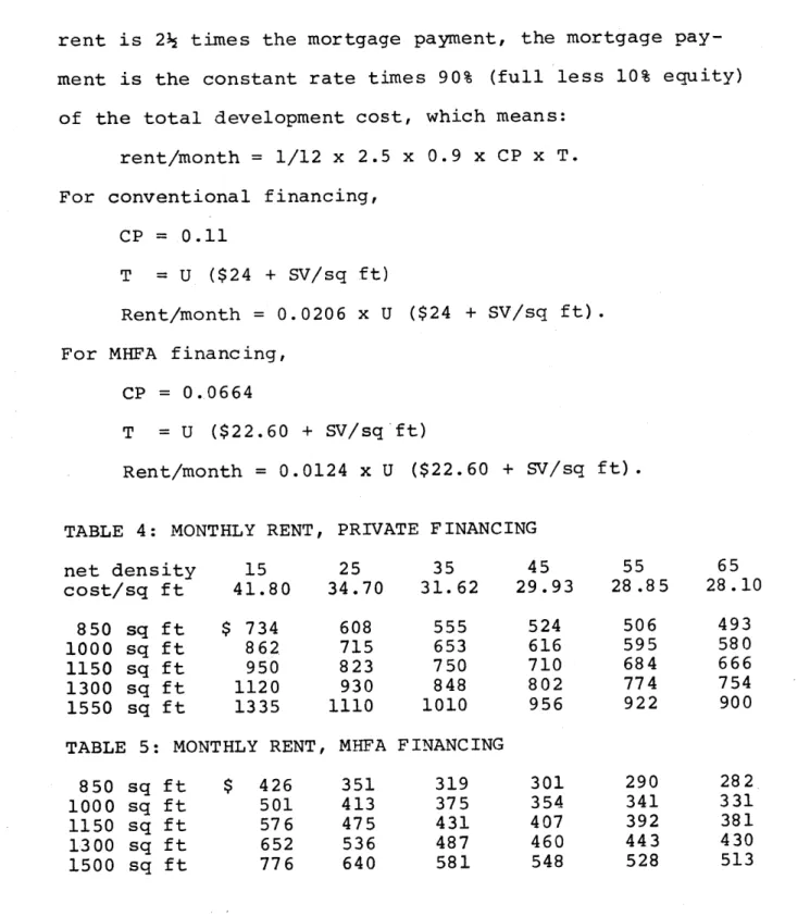
construction. One caution: market rents in Arlington -- one of the measures used to determine rent levels in MHFA
housing -- are quite low due to the fact that most apartments are located in two-family homes, which traditionally command
41) No MHFA housing has as yet been constructed in Arlington. Interest in such a development has
45
lower rents than apartment buildings. The rent determination
should therefore be based on a comparison with rents at
similar apartment developments in Arlington.
4) Auto City. The Theodore Schwamb site can be devel-oped as an auto city, which is currently a major use of the site. Not only is this option questionnable from a market
point of view (as has previously been pointed out) , but such
a development jeopardized the linear park sensibility, the view of the Valley from the Summer Street area, and poses
problems as to the adaptive use of the mill buildings. 4 2 It violates explicitly the goal of providing a "focal point
for the community -- an area in which the people of the
community can utilize personally and in which they can find
a sense of community pride."43
5) Park. The Recreation Facilities Committee and the
Dober Report both suggested a connection between Summer St. playground and the Mill Brook Linear Park. Since the back
side of this site is currently assembled and the Town has
a good working relationship with the owner, the land
assem-bly program suggested by the Department of Planning and Community Development could take the step by acquiring
this land as a park,44 or the land could be "banked" for cummunity needs of the future, or the land could be traded
42) Harry Ellenzweig of the Cambridge architects firm Wallace-Floyd-Ellenzweig has suggested that the large mill building be transformed into an auto museum such as the one at Larz Anderson
Park in Brookline.
43) Arlington Redevelopment Board, Report to Annual Town 'eeting, March 1974; p. A-6.
44) The Arlington Conservation Association has suggested: "(The site's) proximity to Town-owned property suggests the assembly of a really substantial parcel for public-oriented purposes."
46
for development incentives at one of the owners other pro-perties, if appropriate. Acquisition is a good short-term solution, but the ultimate development of the site as an active area must still be studied, and these is always the
issue of the tax base and local politics in acquisition
decions.
6) Shopping Center. The Theodore Schwamb site is flat,
easily accessible, and near the center of the Arlington trading area. An automobile-oriented shopping center on this site seems to be the ideal response to requests and
suggestions for a shopping center in Town. However, the
Economy Summary Report recommended that if such a center
were to be built, it should be located away from
Massachu-setts Avenue because of the volume of traffic generated. Furthermore, the Market Analysis Report recommended develop-ment of Arlington Center as the primary core of shops, and neighborhood centers in East Arlington and Arlington Heights.
7) "Magnet" School. During the continuing school
controversy, a magnet school was somewhat facetiously suggested by a member of the Town's school committee as
one option the Town should consider. This was made in response to a growing regional perspective on metropolitan
busing of school children to achieve racial balance.4 5
Since Arlington's school-age population is declining and
45) This study has been coincidental with rising controversy over "forced bussing" in South Boston. Arlington is more than 99% white with high proportions of people of Irish and Italian descent.
neighboring Cambridge is planning to design a new school
near its border with Arlington, a magnet school could be
built in Arlington thus negating the need for Cambridge to construct a new building. It would change the stagnant though volatile school issue for Arlington, and offer
1200 places to students from Boston. If such a concept
were developed, the Theodore Schwamb site should certainly be considered for such a magnet school. The idea is at
present half-baked and serious discussion of the issue would be very difficult to resolve at this time.
** These options are only ideas for the site. In
proceeding from these concepts to a proposed design for the Theodore Schwamb site, the designer must ask several
questions. The first such question I felt I had was
whether there was anything in particular about this site that would determine how I should proceed in stating the design problem. Such things have to do with site develop-ment costs, the Town's priority criteria, and analyzing the physical context and constraints. To all of these
criteria is added my own intention of presenting a design
for the site as an example or prototype for the development of the Mill Brook Valley, both in its design and this process of design. As a result, many of the aspects of the work
presented here can be translated to other sites in the Valley.