HAL Id: halshs-02610627
https://halshs.archives-ouvertes.fr/halshs-02610627
Submitted on 9 Dec 2020HAL is a multi-disciplinary open access archive for the deposit and dissemination of sci-entific research documents, whether they are pub-lished or not. The documents may come from teaching and research institutions in France or abroad, or from public or private research centers.
L’archive ouverte pluridisciplinaire HAL, est destinée au dépôt et à la diffusion de documents scientifiques de niveau recherche, publiés ou non, émanant des établissements d’enseignement et de recherche français ou étrangers, des laboratoires publics ou privés.
Transport networks
César Ducruet
To cite this version:
César Ducruet. Transport networks. International Encyclopedia of Geography: People, the Earth, Environment and Technology, John Wiley & Sons, Ltd, 2016, �10.1002/9781118786352.wbieg0024�. �halshs-02610627�
Transport networks
Dr. César Ducruet
Centre National de la Recherche Scientifique (CNRS) [email protected]
Pre-final version of the entry published in Richardson D. et al. (Eds.) (2017) The International Encyclopedia of Geography, Wiley-Blackwell & Association of American Geographers,
https://doi.org/10.1002/9781118786352.wbieg0024
Abstract
A transport network is basically defined as a set of connected nodes and links allowing the circulation of goods and/or individuals. Traditionally studied for itself and in rather abstract ways through graph-theoretical and economic lenses, the transport network has increasingly been defined as one component only, albeit crucial, of wider logistical, territorial, and societal realities.
Transport networks may be defined as sets of connected nodes and links allowing for
the circulation of individuals and/or commodities. Traditionally, transport networks
corresponded to physical infrastructure such as roads, railways, canals and rivers, streets and
subway lines, while the concept also includes airline and maritime networks in which nodes are
(sea)ports and airports, as well as telecommunications networks transmitting information and
knowledge flows, such as telephone lines, the Internet, and parent technologies (e.g. telegraph,
mobile phones). In fact, the definition of transport networks can be extended to any support of
circulation, as natural scientists analyze, for instance, termite mounds and fungal networks just
like geographers and engineers study road networks. Tero et al. (2010) have particularly
demonstrated that biological networks such as those built by slime molds are "with comparable
efficiency, fault tolerance, and cost to those of real-world infrastructure networks—in this case,
the Tokyo rail system". While the nature of nodes may vary from one network to the other, those
are often crossings, stations, terminals, cities or countries etc., while links can be of totally
networks belong to the category of "spatial networks" that comprises many other networks such
as so-called technical networks (e.g. power grids) and any network being physically (and often
geographically) grounded into space (see Barthelemy, 2010). Like any other network and
according to the language used by graph theory, a branch of mathematics describing the
topological properties of networks, a transport network may be planar or non-planar (i.e. without
or with crossings between links or "edges"), directed or undirected, weighted or not (i.e. where
links carry a certain quantity e.g. of traffic, distance, or time). A multimodal transport network
may be understood as a "multigraph" where two given nodes are connected via at least two links
of different nature. However, the concept of transport network does not entirely belong to graph
theory; it includes other approaches, such as transport history, spatial analysis, economics, or
engineering, where nodes, links and flows are considered by means of other methods, such as
discourses, policies, actors, governance, planning, and dedicated Geographical Information
Systems for Transport (GIS-T).
Traditionally in geography, transport networks have been the focus of scholars willing
to apply quantitative methods to geographical research. Transport networks and flows received
foremost attention in the 1960s by US geographers. They particularly developed the idea of
ideal-typical sequences of transport network development and applied several graph-theoretical
methods to road and railway networks (Taaffe and Gauthier, 1973). The most renowned model
describes six successive phases inspired from the evolution of transport networks in West Africa
(see Rodrigue, 2014 for a useful online illustration). In a first phase (Scattered ports), a set of
ports along a coastline is characterized by homogeneity in traffic volumes and connection levels
based on local resources. The second phase (Penetration lines and port concentration) witnesses
lines such as rail or canal. The subsequent phases reinforce a path-dependent process by which
initially favored ports continue to grow proportionally to the importance of their inland
accessibility as the corridor emerges gradually through economies of scale. Although this model
has been updated to take into account overseas linkages among ports and more recent trends of
de-concentration, many critiques have been addressed given the linear dimension of the
successive phases which ultimately always lead to concentration in the core and decline in the
periphery. Similar criticism emerged from (trans)port specialists about early urban models, such
as the central place theory, due to its inability incorporating deviations caused by specific
transport configurations (sea-land, intermodal), as in the works of British geographer James Bird.
In the early days however, limited computational power largely explained the reliance upon
small, planar networks easily extracted from city and country maps, while detailed - and often
more voluminous - data about transport flows remained hardly accessible.
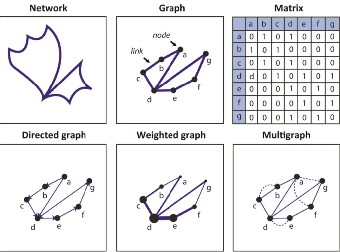
Two central and recurrent themes until nowadays are the topology of transport networks
and the accessibility and centrality of their nodes. The topology may refer to the differences
between the actual layout of a given transport network and its simplified representation as a
graph, i.e. straight lines (or edges) between nodes (or vertices). The graph itself is often
understood as a matrix, sometimes called origin-destination (O-D) matrix, where links exist or
not between nodes ordered in lines and columns (Figure 1). Several measures express a variety
of topological features based on such a graph or matrix (Kansky, 1963), such as the size of the
network (number of nodes and links), its density (number of links per node), completeness
(proportion of existing links in the maximum possible number of links), cliquishness (number of
cycles, transitivity as measured by the average proportion of connected adjacent neighbors in the
network indices makes it possible to apply any graph-theoretical measure such as those found in
Social Network Analysis (SNA) and complex systems, despite fundamental differences in the
nature of the studied networks. Some measures may not be interpreted the same depending on if
people, firms, terminals, or neurons are concerned. Nevertheless, transport networks are common
objects of an emerging "science of networks" notably since physics and computer science started
to analyze such networks with renewed tools and concepts since the late 1990s (Newman, 2010).
Other aspects of transport networks have thus been explored, such as their scale-free and/or
small-world dimensions, the probability for nodes to connect other nodes of comparable size
(assortativity), the average shortest path length, the "rich-club" coefficient, etc. While the degree
distribution follows a power-law function in scale-free networks, small-world networks are
characterized by the existence of dense communities (or subgroups of nodes). The rich-club
dimension refers to networks in which nodes with many links connect primarily with each other.
Great care must be inferred, however, in comparing different networks via such methods because
network indices are often biased by network size. Such measures better apply to the evolution of
a single network over time, or to the comparison between actual and optimal configurations. For
instance, a given (planar) transport network, if weighted by cost or other metric, is best
understood when confronted to its two possible extreme situations, i.e. when all possible links
are built (cf. greedy triangulation) or when only the optimal links are retained (cf. minimum cost
spanning tree). Novel evidence could have been proposed based on such methods when
comparing cities of the world through the configuration of their streets, in terms of planning
models, urban architecture, and overall circulation efficiency (see Barthélemy and Flammini,
Figure 1: Representations of a transport network
At the node level, measures are similar and may look at the immediate environment of
nodes by the number of adjacent neighbors (degree centrality), which correspond to the number
of connected airports for instance. In a road or railway network, cities or stations can be
compared according to their farness (or eccentricity) to other nodes, their occurrence on shortest
paths, etc. In a weighted network, it is also interesting to look at the proportion of traffic
depending on the biggest link; in the case of maritime transport, it revealed the extent to which
certain ports heavily depended on a close competitor despite their high traffic volume (e.g.
Shenzhen vs. Hong Kong). Are larger nodes more central in the transport network? What are the
interesting functions of some nodes, as in an air transport network, some nodes despite having a
few links can still be highly accessible, due to their bridge role between large regions, while
larger and more connected nodes often connect across farther topological and kilometric
distances. In turn, the existence of such "regions" in a transport network is revealed by means of
various techniques of clustering nodes based on certain attributes of connectivity. Are best
connected airports or seaports geographically close? How can commuting flows help delineating
functional urban areas and/or urban regions? Clustering algorithms applied to transport networks,
such as modularity, have, among other results, verified the underlying regional patterns of global
airline and maritime flows. Single linkage analysis, for instance, was applied to
telecommunication flows as early as in the 1960s by US geographers in order to delineate
so-called "nodal regions" in a given urban system.
Complementary methods of network coupling based on the concept of multigraph have
explored how different transport networks share similarities but also vulnerabilities. This is
where the network analysis of transport meets more practical problems of disruptions, rerouting
and congestion, but also optimization. Where should a new node or link be placed in order to
make the transport network(s) more robust to all kinds of failures and targeted attacks? How
should two or more transport networks connected so as to limit such shocks? Such questions are
particularly relevant in the case of networks being largely dependent upon a few large, critical
nodes (e.g. Suez and Panama canals for sea transport). Other aspects to be explored via coupled
networks include the study of potential intermodal shifts, the co-evolution of transport networks,
the multimodal accessibility of cities, among others. Geographers have been particularly keen in
analyzing transport network dynamics under various contexts, such as the impact of deregulation
is a good example of a study combining a dynamical and a multimodal approach when looking at
the evolution of canals, roads, and ports during the English Industrial Revolution. This work
notably demonstrated the positive effect of road development on canal development, but a less
significant role of ports probably due to their earlier existence. It also suggested that investing in
a canal would be less profitable when nearby road improvements were initiated due to higher
uncertainties about potential profits from canal tolls.
Overall, graph-theoretical approaches to transport networks attracted a lot criticism
from more applied research due to its inability including more complex aspects of transport, such
as cost, time, strategies, and scenarios, but also graphical aspects. Indeed, a recurrent problem of
transport networks is their visualization and cartography. Recent advances in graph visualization
algorithms have provided certain solutions to represent, for instance, airline networks as planar
networks using so-called edge-bundling tools, in order to limit the fuzziness of mappings caused
by the intermingling of numerous, space-constrained links and nodes in a large transport network
(Lambert et al., 2013). In turn, exploring the multifaceted dimension of transport networks, such
as their territorial embedding, had mobilized other methodologies than sole graph theory. One
good example is the raster-based analysis of global urban accessibility taking into account no
less than ten different layers in a GIS understood as "friction surface components" (Nelson,
2008). Despite its fundamental graph-theoretical essence, a work on the road accessibility of
European seaports integrated several qualitative aspects such as national regulations in terms of
speed limits and resting times for truckers, the presence and cost of highway tolls, the types and
capacities of main road arteries, and the loading/unloading potential delays at intermodal
junctions (Chapelon, 2006). In the case of urban streets, more qualitative aspects were introduced
boulevards from a cognitive point of view instead of being alignments of arbitrarily separated
segments (Hillier and Hanson, 1984). Such an approach could, by transforming lines into nodes
and nodes into lines, reveal hidden dimensions of the network, the hierarchy of streets, which
was not visible via the more traditional, planar perspective. Many measures did not provide
extraordinary new results, since in general, the traffic volume of transport nodes, which is known
from classic sources, is highly equivalent to any centrality measure: large seaports or seaports
have many links and vice-versa. Rare studies, however, have truly investigated the spatial
determinants of the centrality of transport nodes. These include statistical evidence about the role
of urban and regional socio-economic characteristics mostly in the realm of airline networks,
where cities are nodes and aircraft trips are links. Main results point at noticeable
interdependencies between centrality and the well-being of localities. At least could have been
made evident certain linkages between urban indicators and network indicators for cities such as
in Europe based on airline data, often concluding to a circular causation between urban and
transport development. The spatial dimension was also included, perhaps more by physicists than
by geographers, so as to demonstrate rather trivial, albeit fundamental, properties of transport
networks whereby larger nodes connect more distant nodes on average. Such works shared some
affinities with the regional science perspective on transport hubs where cost and time are central
parameters.
Given such limitations and despite the improvements brought by GIS-T and natural
sciences, geography and other social sciences have increasingly defined transport networks as
elements of wider structures. The shift from quantitative/structural to more behavioral
approaches is one main explanation (Waters, 2006), but also the fact that network analysis
abstract spaces. New concepts that emerged in the late 1990s, such as global production
networks, value and commodity chains, have in common a disregard of pure physical flows,
more concerned by the "flesh" than the "bones" when dealing with actors, mobility, governance,
and territorial issues at various scales. A transport network can thus be approached via more
complex and parent configurations, planned or not planned, such as corridors and gateways,
although the two latter concepts are often subcomponents of the transport network itself.
Another way to place transport networks into a wider analytical perspective has been
proposed by urban geographers, in implicit or explicit ways. Early urban models, such as the
central place theory and up to the New Economic Geography (NEG), approached transport
networks in a rather abstract fashion while conferring them vital importance in the emergence of
cities and hubs within and between regions. Nevertheless, most NEG studies keep considering
cities and regions as equally spaced, thus somewhat excluding the friction exerted by transport
networks on mobility. Studies of urban systems and systems of cities were more keen on
analyzing urban development through the more concrete configuration of transport networks,
such as railway networks. In such a perspective, the transport network is used as a proxy for -
and a material illustration of - wider inter-urban interactions and dynamics in terms of spatial
expansion, functional diversification, hierarchical transformations, and innovation cycles.
Simulation methods are used to extract meaningful properties about both transport and urban
dynamics and to confront estimates with real population data across many decades or centuries.
Yet, there are very rare attempts to integrate urban or regional attributes into transport network
analysis and/or modeling, such as the one of Schintler et al. (2007) analyzing the vulnerability of
More efforts are thus need to push further this integration in order to better meet current
challenges in transport and society.
SEE ALSO: GIS-T; Graph Theory; Maritime Transport; Network Analysis; New Economic
Geography; Rail Transport (Freight); Rail Transport (Passengers); Road Transport; Routing and Navigation; Transport Geography; Transport and Transportation Systems; Visualization
References and Further Readings (9 max.)
Barthelemy, M. (2011). Spatial networks. Physics Reports, 499, 1-101.
Barthélemy, M. & Flammini, A. (2009). Co-evolution of density and topology in a simple model of city formation. Networks and Spatial Economics, 9(3), 401-425.
Bogart, D. (2009). Inter-modal network externalities and transport development: Evidence from roads, canals, and ports during the English Industrial Revolution. Networks and Spatial
Economics, 9(3), 309-338.
Ducruet, C. & Lugo I. (2013). Structure and dynamics of transport networks: Models, methods, and applications. In J. P. Rodrigue, T. E. Notteboom and J. Shaw (Eds.), The SAGE handbook of transport studies (pp. 347-364). London: SAGE Publications Ltd.
Hillier, B. & Hanson, J. (1984). The social logic of space. Cambridge: Cambridge University Press.
Kansky, K. J. (1963). The structure of transportation networks: Relationships between network geography and regional characteristics (Research Paper No. 84). Chicago: University of Chicago.
Lambert, A., Bourqui, R. & Auber, D. (2013). Graph visualization for geography. In C. Rozenblat and G. Melançon (Eds.), Methods for multilevel analysis and visualisation of geographical networks (pp. 81-102). Springer.
Nelson, A. (2008). Estimated travel time to the nearest city of 50,000 or more people in year 2000. Global Environment Monitoring Unit - Joint Research Centre of the European
Commission, Ispra Italy.
Newman, M. E. J. (2010). Networks: an introduction. New York: Oxford University Press.
Rodrigue, J. P. (2014) Conceptual corridor development. The Geography of Transport Systems, https://people.hofstra.edu/geotrans/eng/ch2en/conc2en/corridordev.html
Schintler, L. A., Kulkarni, R., Gorman, S. & Stough, R. (2007). Using raster-based GIS and graph theory to analyze complex networks. Networks and Spatial Economics, 7(4), 301-313.
Taaffe, E. J. & Gauthier, H. L. (1973). Geography of transportation. Englewood Cliffs, NJ, USA: Prentice-Hall.
Tero, A., Takagi, S., Saigusa, T., Ito, K., Bebber, D. P., Fricker, M. D., Yumiki, K., Kobayashi, R. & T. Nakagaki (2010). Rules for biologically inspired adaptive network design. Science, 327(5964), 439-442.
Waters, N. (2006). Network and nodal indices. Measures of complexity and redundancy: A review. In A. Reggiani and P. Nijkamp (Eds.), Spatial dynamics, networks and modelling (pp. 13-33). Northampton: Edward Elgar Publishing.
Xie, F. & Levinson, D. (2009). Modeling the growth of transportation networks: A comprehensive review. Networks and Spatial Economics, 9(3), 291-307.
Key Words