HAL Id: hal-01825207
https://hal.archives-ouvertes.fr/hal-01825207
Submitted on 28 Jun 2018
HAL is a multi-disciplinary open access
archive for the deposit and dissemination of sci-entific research documents, whether they are pub-lished or not. The documents may come from teaching and research institutions in France or abroad, or from public or private research centers.
L’archive ouverte pluridisciplinaire HAL, est destinée au dépôt et à la diffusion de documents scientifiques de niveau recherche, publiés ou non, émanant des établissements d’enseignement et de recherche français ou étrangers, des laboratoires publics ou privés.
RINGMesh: An open source platform for Shared Earth
Modeling.
François Bonneau, Arnaud Botella, Antoine Mazuyer, Pierre Anquez,
Benjamin Chauvin, Guillaume Caumon
To cite this version:
François Bonneau, Arnaud Botella, Antoine Mazuyer, Pierre Anquez, Benjamin Chauvin, et al.. RINGMesh: An open source platform for Shared Earth Modeling.. 80th EAGE Conference and Exhibition 2018, Jun 2018, Copenhague, Denmark. �hal-01825207�
RINGMesh: An open source platform for Shared Earth Modeling.
author: Francois Bonneau, Arnaud Botella, Antoine Mazuyer, Pierre Anquez, Benjamin Chauvin, Guil-laume Caumon
RINGMesh is an open-source platform proposing a data model to support Shared Earth Modeling with unstructured meshes. This initiative is complementary to ontologic-based syntax and standard file for-mats. We provide features not only to share data and interpretation but also a concrete implementation framework to convert and manipulate models with the requirements needed by geomodelers, solvers and simulators. We advocate that this opens new perspectives for more efficient subsurface modeling workflows that harness uncertainties by confronting data, models and interpretations.
Introduction
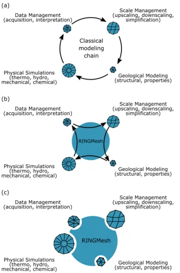
A geological model aims at describing, representing and characterizing subsurface heterogeneities. It gathers raw data and their analysis in the light of the knowledge hold by an expert who has built the model. There are as many structural interpretations as people looking at the data (Bond et al., 2007; Bond, 2015). Shared Earth Modeling (SEM) aims at sharing data, interpretations and uncertainties collected during the modeling chain (Ringrose and Bentley, 2015). It has to provide to any modeler/user (geophysicists, geologists, reservoir engineers and business experts) the level of knowledge they need to support decisions. As each subdiscipline tends to use its own tools, most initiatives since the 90’s have aimed at developing standards both conceptually (ontology-based (Perrin, 1998; Mastella et al., 2007)) and in standard file formats (RESCUE and then RESQML1 (Morandini et al., 2011, 2017)). Indeed, standards are a key component to enable communication between the various communities that build and use subsurface models (see Perrin and Rainaud (2013) for a review). These initiatives significantly facilitate linear workflows whereby each step provides inputs for the next one (Fig. 1 (a)). We suggest that more is needed to further foster innovation in subsurface modeling.
Fundamentally, modeling should support coupled physical processes in complex geological settings at the scale of interest. Both in bottom-up and top-down approaches, the feedback coming from physical simulations (reservoir production data, subsidence, acoustic sensors, etc.) must be re-injected spatially to better characterize geological features and reduce uncertainties (e.g., Irakarama et al. (2017)). This is a highly challenging problem, which calls for a common geological data model that is able to represent knowledge at multiple scales and transfer information gained from various sources. We suggest that implementing such a data model and associated functionality in a common, extensible and open-source software library can significantly help academic and industry researchers to embrace these challenges. When several applications are involved, it can ensure the validity and the retro-compatibility of models when migrating from one software to another, which is a mandatory for editing interpretation performed at any stages of the modeling chain.
In this work, we present RINGMesh2, which is a software platform supporting the alternative integrated subsurface modeling workflows described in Fig. 1 (b-c)). More precisely, RINGMesh propose an open-source geomodel data structure that can be used to implement operations on subsurface models. It allows for connecting several applications by converting the geomodels into various file formats. Finally, it enables the direct use of third-party mesh data structures which clear the path for a tight coupling of physical and geological modeling.
An open-source data model to deal with the geometry and the topology of geological objects RINGMesh implements a representation of subsurface organization and geometry using a set of geologi-cal and geometrigeologi-cal entities (Fig.2). The GeoModel data structure combines geometrigeologi-cal and topologigeologi-cal information with geological knowledge and interpretations in an abstract and flexible design (see sec-tion ). Each geometrical entity is associated with a mesh data structure that hold the entity discretizasec-tion.
1http://www.energistics.org 2http://ringmesh.org
Data Management (acquisition, interpretation) Scale Management (upscaling, downscaling, simplification) Geological Modeling (structural, properties) Physical Simulations (thermo, hydro, mechanical, chemical) Classical modeling chain (a) (c) Data Management (acquisition, interpretation) Scale Management (upscaling, downscaling, simplification) Geological Modeling (structural, properties) Physical Simulations (thermo, hydro, mechanical, chemical) RINGMesh (b) Data Management (acquisition, interpretation) Scale Management (upscaling, downscaling, simplification) Geological Modeling (structural, properties) Physical Simulations (thermo, hydro, mechanical, chemical) RINGMesh
Figure 1 (a) Shared Earth Modeling is often based on the classical modeling chain (Ringrose and Bentley, 2015). This involves transfer of relevant information between distinct software applications, for which model validity on both ends is difficult to ensure. (b) RINGMesh provides features to check and fix some of these validity issues through a common and open data model implementation. (c) RINGMesh’s abstract data structure gives the opportunity develop new methods or wrap existing implementations to address integrative modeling challenges.
The default mesh data structure is implemented in the geometric algorithm library “Geogram”3. For in-stance, regions can be meshed with tetrahedra, hexaedra, prisms and pyramids; surfaces can be meshed with triangles or any other polygons; lines can be meshed with segments; and corners are isolated mesh nodes.
The “GeoModel” geometrical description is similar to the Gmsh4 (Geuzaine and Remacle, 2009) and MSTK5 (Garimella, 2004) representations. It is made of geometrical entities of various dimensions. Each region is bounded by surfaces, each surface is bounded by lines and each line is ended by two corners. A geometrical entity stores a list of upward and downwards entity adjacencies. The topology of the GeoModel can be investigated through “boundary/incident” relationships of geometrical entities. A geological entity is a set of geometrical entities that shares the same geological feature (e.g., a horizon, a fault or a layer). For instance, a horizon is a set of surfaces. A “parent/child” relationship drives the access from the parent geological entity to its constitutive geometrical entities (children). Additionally, the conceptual data and knowledge collected during the modeling chain (such as the stratigraphic
col-3http://alice.loria.fr/software/geogram 4http://gmsh.info
umn) are associated to geological entities. The current implementation needs to be improved to integrate an exhaustive description of the ontological based geological model (Perrin and Rainaud, 2013). Together with the data model, RINGMesh provides an extensible set of test functions which check the geometrical and geological consistency of a particular GeoModel instance.
Layer Interface Contact Region Surface Line Corner (a) Geological Model
(c) Geometrical Entities
(b) Geological Entities
Figure 2 RINGMesh implements the “GeoModel” to hold the geometry and the topology of geological models. The GeoModel (a) is made of geological entities (b). The organization, the geometry and the connectivity of geological objects can be accessed through the “parent/child” relationship defined between geological entities and geometrical entities (c). The connectivity of geometrical entities is explicitly defined by “boundary/incident” relationships.
A smart converter of geological model file format
RINGMesh gathers an array of features to load, export, repair and visualize “GeoModels”. These con-verters are essential, as the main current use of RINGMesh is to communicate with external geomodeler, mesher and simulation software (Fig. 1 (b)). Classically, exchanging data between applications can be time-consuming, and errors are often detected quite late in the process. RINGMesh helps the early detection of transfer problems by performing validity checks, and helps their automatic resolution by proposing classical fixes for geometrical issues.
Ongoing development efforts aim at further supporting classical databases and standard file formats, brings the opportunity not only to transfer but to convert the information between software. These features are essential in a SEM project.
An abstract mesh data structure to bind software and libraries
Since the first implementation of the GeoModel (Pellerin et al., 2017), an abstraction level has been added to manipulate purely topological GeoModel. This gives the opportunity to consider various topo-logical representations without relying on a particular mesh data structure. This is achieved by an ab-stract mesh object supporting the RINGMesh features. The default mesh data structure implementation is provided by Geogram, but alternative data structures can be used (e.g., a discretized mesh or a math-ematical parameterization (spline, NURBS)). This enlarges the representation capability of RINGMesh and may provide a direct wrapper to physical simulators, meshers and geomodelers (Fig. 1 (c)). We are currently working on a proof of concept with MFEM6by specifying the RINGMesh abstract mesh with the MFEM data structure. Finite Element simulations can then be directly performed on RINGMesh entities. This clears the path for direct physical feedback on the geological model.
Conclusion
RINGMesh is an open-source platform to support R & D projects for integrative numerical geology. This initiative aims at providing some of the missing pieces needed for a true Shared Earth Model implementation.
(1) It enhances the communication between meshers, solvers and geomodelers to reduce subsurface uncertainties.
(2) It adapts input files to GeoModel requirements by performing validity tests. This smart converter needs to be enhanced both to diversify input and output file formats and to integrate more validity check and repairing functionalities.
(3) The GeoModel features use a generic mesh data structure. Specifying it allows to encapsulate various technologies in the heart of the data model. The idea is to enable flow and mechanical simulation by wrapping software directly in the RINGMesh platform. We see this as an essential component to perform joint inversion on realistic geological models.
(4) RINGMesh proposes an extensive and mutable design. We encourage the community to develop their own applications and workflows (Botella, 2016; Anquez et al., 2017; Chauvin et al., 2017; Mazuyer et al., 2018) and to feed the project with generic tools and features.
(5) It is developed in C++11 and continuously tested using integration tools to ensure stability. Non regression and unit tests are run before and after any contribution to the main repository on github (https://github.com/ringmesh/RINGMesh).
(6) As the project evolves quickly, an up-to-date list of features and tutorials are available on the website of the project (http://ringmesh.org).
Acknowledgements
This research was performed in the frame of the RING project at the Université de Lorraine. We would like to thank for their support the industrial and academic sponsors of the RING-GOCAD Consortium managed by ASGA. We particularly thank Total S.A. for their active participation in RINGMesh devel-opment. We also acknowledge Inria for the Geogram library used in RINGMesh.
References
Anquez, P., Caumon, G., Pellerin, J. and Levy, B. [2017] Automatic sealing and simplification of 3D geological surface models using topology recovery. In: 79th EAGE Conference Exhibition. EAGE. Bond, C.E. [2015] Uncertainty in structural interpretation: Lessons to be learnt. Journal of Structural
Geology, 74, 185–200.
Bond, C.E., Gibbs, A., Shipton, Z. and Jones, S. [2007] What do you think this is ? "Conceptual uncertainty” in geoscience interpretation. GSA today, 17(11), 4.
Botella, A. [2016] Génération de maillages non structurés volumiques de modèles géologiques pour la simulation de phénomènes physiques. Phd, Université de Lorraine.
Chauvin, B., Lovely, P., Stockmeyer, J., Plesch, A., Caumon, G. and Shaw, J. [2017] Validating novel boundary conditions for 3D mechanics-based restoration: an extensional sandbox model example. AAPG Bulletin.
Garimella, R. [2004] MSTK-A Flexible Infrastructure Library for Developing Mesh Based Applications. In: 13th International Meshing Roundtable. Williamsburg, 213–220.
Geuzaine, C. and Remacle, J.F. [2009] Gmsh: A 3-D finite element mesh generator with built-in pre-and post-processing facilities. International Journal for Numerical Methods in Engineering, 79(11), 1309–1331.
Irakarama, M., Cupillard, P., Caumon, G. and Sava, P. [2017] Appraising structural models using seismic data: problem and challenges. In: 87th SEG Annual Meeting. SEG.
Mastella, L., Perrin, M., Abel, M., Rainaud, J.F. and Touari, W. [2007] Knowledge Management for Shared Earth Modelling. EUROPEC/EAGE Conference and Exhibition, (June 2007).
Mazuyer, A., Giot, R., Cupillard, P., Thore, P., Conin, M. and Leroy, Y. [2018] Stress estimation in reservoirs using an integrated inverse method. Computers & Geosciences.
for Shared Earth Model Data Exchanges between Commercial Modelling Applications and In-House Developments, Demonstrated on Actual Subsurface Data. SPE Digital Energy Conference and Exhi-bition.
Morandini, F., Rainaud, J.F., Poudret, M., Perrin, M., Verney, P., Basier, F., Ursem, R., Hollingsworth, J. and Marcotte, D. [2017] RESQML Version 2.0.1 Makes it Easier To Update a Reservoir Model. In: SPE Europec featured at 79th EAGE Conference and Exhibition. Society of Petroleum Engineers. Pellerin, J., Botella, A., Bonneau, F., Mazuyer, A., Chauvin, B., Levy, B. and Caumon, G. [2017]
RINGMesh: A programming library for developing mesh based geomodeling applications. Comput-ers & Geosciences, 104, 93–100.
Perrin, M. [1998] Geological consistency : an opportunity for safe surface assembly and quick model exploration. In: 3D Modeling of Natural Objects, A Challenge for the 2000’s. Nancy, France, 4–5. Perrin, M. and Rainaud, J.F. [2013] Shared Earth Modeling: knowledge driven solutions for building
and managing subsurface 3D geological models.