PAGE 1 OF 95
Application of Selected New Urbanist Principles
to Residential Infill Developments
in Mature Suburbs of Greater Boston
byAndrew Port
B.S.L.A., Landscape Architecture University of Massachusetts, Amherst, 1999
Submitted to the Department of Urban Studies & Planning In Partial Fulfillment of the Requirements for the Degree of
Master in City Planning
at the
Massachusetts Institute of Technology
June 2004
©2004 Andrew R. Port. All rights reserved.
The author hereby grants to MIT permission to reproduce and to distribute publicly paper and electronic copies of this thesis document in whole or in part.
Signature of Author
Department of Urban Studies & Planning May, 2004 Certified by
Terry Szold Adjunct Associate Professor of Land Use Planning Thesis Advisor Accepted by
Dennis Frenchman Professor of the Practice of Urban Design Chair, Master in City Planning Program
PAGE 2 OF 95
Application of Selected New Urbanist Principles
to Residential Infill Developments
in Mature Suburbs of Greater Boston
byAndrew Port
Submitted to the Department of Urban Studies & Planning In Partial Fulfillment of the Requirements for the Degree of
Master in City Planning Abstract
The New Urbanist movement has grown considerably in the past decade in response to the impacts of sprawl in the United States. The crisis of sprawl has been caused in large part by poorly crafted land use regulations, many of which mandate sprawl. While an abundance of contemporary land use and planning literature focuses on the concepts of New Urbanism, little attention has been given to their regulatory implementation. And while developers and architects have responded to the problems of sprawl with plans for the development of new communities, few have looked at the opportunity to retrofit existing suburbs. This research adds to the field by illustrating how selected New Urbanist principles can be viably applied to residential infill developments in mature suburbs (specifically Greater Boston) if alternative regulations are adopted. Such development will not only preserve natural resources at the urban edge, but will ensure the efficiency and vitality of our mature core communities.
Four developments in communities’ representative of the Greater Boston region illustrate the contemporary (conventional) form of residential infill and two are given a post-mortem design alternative (New Urbanist). These alternative developments illustrate the viability of applying New Urbanist principles to residential infill in mature suburbs of Greater Boston. A model hamlet development regulation, used as a guide in developing the alternative designs, illustrates that:
1. The application of New Urbanist principles to residential infill is a viable alternative to conventional sprawl development at the fringe of our mature communities; and
2. No drastic paradigm shift is necessary to implement the principles of New Urbanism in infill residential development. Even small changes to local land use regulations can afford significant improvements to the sustainability of our local land use regulations.
The framework and results of this research are transferable to cities and towns across the Commonwealth and our nation. It is my hope that the principles and recommendations herein will be applied accordingly. Thesis Supervisor: Terry Szold
Title: Adjunct Associate Professor of Land Use Planning Thesis Reader: Eran Ben-Joseph
PAGE 3 OF 95
Biographical Note
Andrew R. Port
Andrew Port is a candidate for a Master of City Planning degree in the Department of Urban Studies and Planning at the Massachusetts Institute of Technology. His academic focus combines community planning, land use regulation, and urban design. His primary interests lie in master-planning, specific plans, land use regulation, community outreach & community building, and GIS. Andrew was born and raised in Newton, Massachusetts and has lived in Massachusetts for the past twenty-seven years. He attended the Department of Landscape Architecture and Regional Planning (LARP) at the University of Massachusetts, Amherst from 1995 to 1999 and graduated with a Bachelor of Science in Landscape Architecture (BSLA) Degree in 1999.
At that time, Andrew took a job working as City Planner for the City of Peabody, Massachusetts. Since that time he has worked as a municipal planner, addressing a broad range of issues facing communities across the Commonwealth. He is currently coordinating a Comprehensive Rezoning Project for the City of Peabody, including revisions to the Zoning Ordinances, Site Plan Review and Subdivision Regulations, as well as a new provision for Architectural Design Review.
Andrew is a member of the American Planning Association (APA) and is applying for membership to the American Institute of Certified Planners (AICP) this May.
PAGE 4 OF 95
Dedication
This work, a small contribution of my life’s work as a planner, is dedicated to the memory of my father Solomon W. Sidman whose strength has walked with me through grad school, and lives on through my efforts. “If a man does good because of you, his deeds will be as though they were your own.”
Acknowledgments
First and foremost I would like to thank my thesis advisor Terry Szold for inspiration and encouragement during my graduate studies at MIT. Terry helped me to streamline and refine my work while retaining all of the enthusiasm, and passion I demand of myself. I am also grateful to Eran Ben-Joseph for his feedback and advice in the development of this thesis.
I wish to thank my mother Carol, my sister Laura, and my new niece Rebecca for being patient and forgiving of me during the past two years of preoccupation with my Masters. Never forget the pride of serving as retainer for past generations and pillar for those to come.
My thanks to all of the wonderful people in the City of Peabody, where I have practiced as a municipal planner for the past five years. I have learned ten times more through my professional work and your common sense than I could possible have gained in two years of academia. I am particularly thankful for my early fostering by former Community Development and Planning Director Judith Otto. Your words of wisdom and praise are very much appreciated.
Thank you Anna for taking the time to read and proofread this anvil of text … twice. Thank you Ali Corwin for dragging me all over the state on study breaks throughout this time, for listening to my inner battles, and for helping to lift me forward and reach my personal goals. Thanks to my housemates Anna and Ashish for reassuring me in times of stress and to good friends Neal, Vera, Joe, Allison, and yes even Anna … for their camaraderie. J
Special thanks to all my professors at MIT and UMass Amherst who trained me in the broad range of skills necessary for municipal planning. You have illuminated the meaning of quality land use planning, urban design, community development, social justice, and capacity building (among others). Lastly, I am grateful to my classmates from DUSP for broadening my understanding of the profession and your willingness to share personal struggles and teamwork. Together we will lift the world forward.
Special Thanks
Appreciation is given to the planning and other town staff from each of the communities discussed in this research for giving their time, information, and insights:
• Christopher Reilly, Town Planner, Town of Reading • Diane Beecham, Town Planner, Town of Westwood • Alicia Alteiri, Town Planner, Town of Boxborough • Laura Harbottle, Town Planner, Town of Scituate
PAGE 5 OF 95
Table of Contents
Title Page 1
Abstract 2
Biographical Note 3
Dedication & Acknowledgements 4
Table of Contents 5-6
Chapter 1 Executive Summary 7
Chapter 2 Introduction 8-20
Chapter 3 Background on New Urbanism 21-30
Chapter 4 Background on Land Use Planning in Massachusetts 31-35
Chapter 5 Community Selection Process 36-46
Chapter 6 Conventional Residential Developments 47-50
A. Boxborough – Green Acres Subdivision B. Reading – Carriage Estates & Cory Lane C. Scituate – Cornerstone Estates
D. Westwood – Conifer Lane
Chapter 7 Post-Mortem/New Urbanist Alternatives 51-55
A. Boxborough – Green Acres Subdivision • The Conventional Subdivision Development • The Alternative Development
• Comparison: Key Findings & Obstacles to the New Urbanism B. Reading – Carriage Estates & Cory Lane
• The Conventional Subdivision Development • The Alternative Development
PAGE 6 OF 95
Table of Contents, cont.
Chapter 8 Obstacles to Implementing New Urbanism 56-63
Chapter 9 Conclusion: Findings & Recommendations 64-68
Appendices Appendix A: Charter of New Urbanism 69-72
Appendix B: Model Hamlet Development Bylaw 73-90
PAGE 7 OF 95
Chapter 1:
Executive Summary
“Development patterns should not blur or eradicate the edges of the metropolis. Infill development within existing urban areas conserves environmental resources, economic investment, and social fabric, while reclaiming marginal and abandoned areas. Metropolitan regions should develop strategies to encourage such infill development over peripheral expansion.”
~Charter of the New Urbanism
This thesis is a proposition for changes to local land use regulations in the Commonwealth of Massachusetts. The New Urbanist movement has grown considerably in the past decade in response to the impacts of sprawl in the United States. The crisis of sprawl has been caused in large part by poorly crafted land use regulations, many of which mandate sprawl. While an abundance of contemporary land use and planning literature focuses on the concepts of New Urbanism, little attention has been given to their regulatory implementation. And while developers and architects have responded to the problems of sprawl with plans for the development of new communities, few have looked at the opportunity to retrofit existing suburbs. This research adds to the field by illustrating how selected New Urbanist principles can be viably applied to residential infill developments in mature suburbs (specifically Greater Boston) if alternative regulations are adopted. The intent is to provide a much needed link between theory and practice. Such development will not only preserve natural resources at the urban edge, but will ensure the efficiency and vitality of our mature core communities.
Four developments in communities’ representative of the Greater Boston region illustrate the contemporary (conventional) form of residential infill and two are given a post-mortem design alternative (New Urbanist). These alternative developments illustrate the viability of applying New Urbanist principles to residential infill in mature suburbs of Greater Boston. A model hamlet development regulation, used as a guide in developing the alternative designs, illustrates that:
1. The application of New Urbanist principles to residential infill is a viable alternative to conventional sprawl development at the fringe of our mature communities; and
2. No drastic paradigm shift is necessary to implement the principles of New Urbanism in infill residential development. Even small changes to local land use regulations can afford significant improvements to the sustainability of our local land use regulations.
The framework and results of this research are transferable to cities and towns across the Commonwealth and our nation. It is my hope that the principles and recommendations herein will be applied accordingly.
PAGE 8 OF 95
Chapter 2:
Introduction
Purpose of ThesisNew Urbanism has been hailed as the most significant movement in urban planning and architecture in this century. (Song, 1) “In brief, the principles of New Urbanism include high density, mixed-use neighborhoods; convenient public transit, bicycle paths and pedestrian-friendly street networks; strategically placed open spaces; and architecture designed to foster social interaction” (emphasis added).1 Critics argue that the design of isolated New Urbanist communities on greenfield 2 sites
fails to address the complex issue of splicing New Urbanism into existing communities. As a municipal planner in Massachusetts for five years now I have seen the consequences of crude and narrowly constructed land use regulations, many of which encourage or mandate sprawl. With a background in Landscape Architecture, it is clear to me that the majority of land use regulations across our Commonwealth fail to address the art of urban design, place-making, and the making of
community. The purpose of this thesis is to assess the viability of incorporating key New Urbanist3
design principles into residential infill4 developments in mature suburbs5 of Greater Boston.6
Curbing Sprawl
The wasteful form of today’s sprawling (outward) urban growth continues to cost our Commonwealth a loss of natural resources, lack of civic proximity, and attendant increase in infrastructure and transportation costs. NIMBY7 opposition to compact residential development
remains in part because of our failure as planners to engage and educate the general public, and to provide viable examples of such New Urbanist developments, which may (in turn) allow the public an educated comparison.
1New Urbanism (NU), Creating livable neighborhoods, Available on the web at http://www.newurbanism.org, 2002. 2 Greenfield Development: Development of previously undeveloped lands such as fields or forests in communities
currently below 50% “Buildout” (of total developed land area) according to a recent Buildout analysis conducted by the State of Massachusetts.
3 New Urbanist Development: Development adhering to established key principles of New Urbanism (For the purposes
of this research, compact development with sufficient provision for preserved greenways and common spaces).
4 Infill: The use of vacant land and property within a built-up area for further construction or development rather than
on new undeveloped land outside the city or town. Residential Infill: Development of residential neighborhoods in mature suburbs and distinct from greenfield development outside the urban core established by these communities.
5 Mature Suburbs: Largely developed communities with high build-out ratios (communities currently above 50%
“Buildout” (of total developed land area) according to a recent Buildout Analysis conducted by the State of Massachusetts., Executive Office of Environmental Affairs (EOEA).
6 Greater Boston: Municipalities in the Metropolitan Area Planning Council (MAPC) region.
7 “Not In My Back Yard” (NIMBY), a term used by planners to express community and resident opposition to
PAGE 9 OF 95
The negative results of our recent development patterns are both irresponsible and unnecessary. If we assume that the call of “New Urbanists” is a noble one (i.e. the creation of more compact and livable communities), then the important question of implementation remains. Can the New Urbanism be viably introduced into local land use regulations in Massachusetts? What would it mean to insert New Urbanism into mature cities and towns? The benefits of infill over outward sprawl include the preservation of open space and the creation of “places worth caring about.”8
The Common in Commonwealth
Figure 2.1. A plan of land parcels in the Town of Sudbury Massachusetts in 1640. “Early settlers were granted individual landholdings arranged in relation to common pasture land and a central meeting house.” (Conzen, 212) The compact village form is oriented toward the common open space, and the surrounding landscape is preserved in its natural form and for agricultural uses.
The image above depicts the traditional New England form of settlement; a compact cluster of dwellings and other uses oriented around a common area in the center. As this figure shows, it is
8
PAGE 10 OF 95
the compact urban form, sharp contrast between developed and undeveloped areas, and shared common spaces that defines traditional New England development patterns. This neo-traditional form of development illustrates several key principles of New Urbanism. This form of residential development ensures:
1. Compact and Efficient Urban Form (both in individual lot size and clustering of the whole) 2. Emphasis on and Definition of Common Space (the public realm)
“In the early 1900’s, much of the residential housing was concentrated around traditional town and village commons within walking distance of commercial and retail activity as well as churches and other cultural institutions. This scale of living allowed people to gather and interact closely with one another on a daily basis, providing a secure network of relationships… Some say "smart growth" or "new urbanism" is the way to mitigate the impacts of growth by relieving development pressure on “greenfield" sites. Ironically, today’s "new urbanism" movement touts the very land use patterns for which Massachusetts is historically famous. In this way, Community Preservation is about bringing the good ideas of the past into the future.” (EOEA, 3)
This cozy form of development is rarely found now in contemporary residential development across Massachusetts, whether infill or greenfield. The reason for this is simple. Land use regulations developed over the past century have reduced our traditional forms of settlement to legal and engineering principles such as use restrictions, and nonsensical dimensional requirements. Local land use regulations in Massachusetts are similar to those adopted across much of our nation, emphasizing (in place of the above principles) the following:
1. Arbitrary Separation of Uses and Structures & Complete Dependence on the Automobile 2. Inadequate Provision for Human-Scaled Civic Spaces
In a year 2000 report entitled, “The State of Our Environment,” prepared by the Massachusetts Executive Office of Environmental Affairs (EOEA), the state defines the threat of sprawl as “low density, single-use development on the urban fringe that is almost totally dependent on private automobiles for transportation.” The report provides a detailed explanation for the numerous societal costs of sprawl, from loss of open space, to pollution and infrastructure costs, to loss of “our sense of place.”
The EOEA report indicates that “Since 1950, the population density of developed land in Massachusetts has decreased by more than 50%, from 11.9 persons/acre to 4.97 persons/acre. Each of us now consumes more than twice as much developed land as we did in 1950. Sprawl is not a function of population growth. Between 1950 and 1990, the population of Massachusetts increased by only 28%. In that same period, the amount of developed land increased by 188%. We have used up more land in the half-century since 1950 than was developed in the three previous centuries.”
PAGE 11 OF 95 On the New Urbanism, the report has this to say:
“In other parts of the country, there is a strong push to design and build new towns that have main streets with shops and offices and apartments all mixed together, and residential neighborhoods within walking distance. This concept is called the “New Urbanism.” But in Massachusetts, the New Urbanism is really the old urbanism … Massachusetts already possesses three-centuries-worth of cities and towns that are attractive, livable, and environmentally sound.”
With regard to contemporary sprawl, the report says “There aren’t any town greens or town squares. Often there aren’t even any sidewalks.” (EOEA) A comprehensive Buildout Analysis conducted for each city and town in the Commonwealth lead the state to this conclusion about local land use regulations:
“The Buildout analyses have shown consistently that most current zoning codes allow far more development than the community could possibly want or absorb and that growth would often occur in inappropriate places.”
The report also notes that existing zoning makes it impossible to reproduce the “livable, pedestrian-friendly” neo-traditional forms of development, such as mixed-use downtowns, and compact (cluster) residential developments. The report recommends that local governments “reform local zoning to encourage appropriate development patterns.” However, this report stops short of making the connection between the percentage of local communities zoned solely for single-family residential development, and their corresponding high Buildout values. As discussed in Chapter 4, the vast majority of our Commonwealth is zoned for subdivision as single-family dwelling lots. Our poor urban form is in large part a cause of social decay and the loss of community pride across this state and our nation. Could a gentle paradigm shift from the influence of private property rights and euclidean zoning toward New Urbanist principles viably further the reinvention of public space and the preservation of greenways for generations to come? 9
9 “Towards the Reinvention of Public Space: Implications of the Recent work of Andres Duany and Elizabeth
PAGE 12 OF 95
Figure 2.2.: A simple graphic showing population density illustrates the growth pressures radiating from the Greater Boston region. It is not hard to envision this map decades from now, covered in red, orange, and yellow, with only traces of green. Charles Elliot once said, “The time is coming when it will be hard to find within a day’s journey of our largest cities a single spot capable of stirring the soul of man to speak in poetry.”
In a report entitled, “Conserving our Commonwealth: A Vision for the Massachusetts Landscape,” the Trustees of Reservations note that “unplanned development and sprawl are outrunning the opportunities for protecting valuable open space and for linking protected lands into a coherent open space network.” Among other recommendations, this report argues that we must:
• Create stronger incentives to encourage (or to mandate) cluster development; and • Locate new development in established urban areas and village centers.
PAGE 13 OF 95
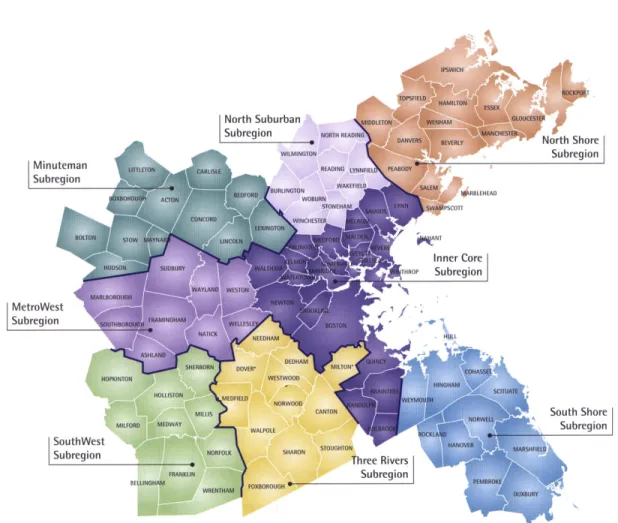
Figure 2.3: The MAPC Region (Greater Boston, for the purposes of this research).
In a report entitled, “A Decade of Change: Growth Trends in the Greater Boston Area – 1990 to 2000,” the Metropolitan Area Planning Council (MAPC) emphasizes the desperate need for regional planning due to current growth pressures and the attendant growth management issues. The two primary “growth trend” changes noted in the report are “the rapid escalation of housing prices and rapid consumption of previously undeveloped land.” Both of these can be attributed in large part to a blanket of excessive large-lot single-family zoning, which not only increases home prices and related development costs, but consumes an inordinate amount of our greenfields.
MAPC estimates that 22,290 acres of land were developed in the Greater Boston region between 1990 and 2000, “an average of 7.6 acres lost per day, the vast majority of which were developed for single-family homes.” (MAPC) The following chart summarizes this relationship for the Greater Boston region:10
10 Simplified version of table shown on page 100 of report entitled, “A Decade of Change: Growth Trends in the
PAGE 14 OF 95
Undeveloped Single-Family
Year Total Acres % of Land Total Acres % of Land
1991 547,003 59.6 % 281,640 30.5 %
1999 524,713 57.1 % 300,879 32.7 %
Difference -22,290 -2.5 % 19,239 2.2 %
Table 2.1. The relationship between total land consumption from new development and total land area of our communities zoned solely for by-right large-lot single-family dwellings.
Among the four iconic mature suburban communities selected in Chapter 5, the Buildout ratios and percentages of land zoned “single-family” were as follows:
% of Total Land Area Built-Out % of Total Land Area Zoned “Single-Family”
Boxborough 63.0 % 68.9 %
Reading 88.0 % 93.9 %
Scituate 82.0 % 93.9 %
Westwood 89.0 % 79.9 %
Table 2.2. The relationship between percent community buildout (of total land area) as compared with the percentage of land area zoned solely for by-right large-lot single-family dwellings, in communities selected for this analysis.
PAGE 15 OF 95 Wisdom of the Ages
“Everything that can ever be said has already been said, but since no one was listening it has to be said all over again.”
~Unknown
Figure 2.4. An old village plan from England, depicting dwellings oriented around a common green. Notice the sharp transition between the urban area and beyond. “The village is the local climax.” (Brown)
Compact form and the definition of common space are central themes in the New Urbanism, a movement arguing for the return to traditional urban development patterns, proven over centuries of human settlement. The basic human need for social interaction is completely neglected in today’s large-lot single-family subdivisions, where no consideration is given to proximity or civic spaces.
In the book “The Not So Big House,” author Sarah Susanka illustrates the unfortunate American “starter castle complex” – the notion that houses should be “designed to impress rather than to nurture.” It is this same model, and the simplification of residential development to a mere subdivision of land, which characterizes today’s “cookie-cutter” form of residential development in New England. And just as “more rooms, bigger spaces, and vaulted ceilings do not necessarily give
PAGE 16 OF 95
us what we need in a home,” lack of consideration for the whole in our new neighborhoods, results in a wasteland of individual homes that fail to provide a sense of place or larger meaning. (Susanka, 3) Concern for the public realm and a relationship to larger society may be the most central tenants of New Urbanism, and of traditional New England development patterns.
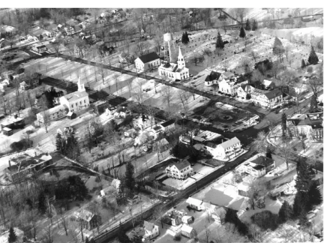
Figure 2.5. A photograph of the Town Common in Petersham, Massachusetts captures the traditional New England settlement.
PAGE 17 OF 95
Figure 2.6. An aerial photograph of the Common in Belchertown, Massachusetts reminds us that there are still centuries-old civic spaces and compact urban forms left to inform today’s residential development.
The following chapters illustrate the application of New Urbanist principles to the development of residential infill in mature suburbs of Greater Boston. This analysis is intended to demonstrate the viability and benefits of New Urbanism as a framework for residential infill as an alternative to wasteful sprawl at the fringes of our existing suburbs.11 It is time to rethink our “by-right”
development patterns, and to sculpt them into expressions of efficiency and timeless human needs.
Hypothesis & Argument
My hypotheses for this research were three-fold:
1. Residential infill development in mature suburbs of Greater Boston has been largely uninfluenced (and unimproved) by the New Urbanism.
11 Infill as defined by the State is “Developing on empty lots of land within an urban area rather than on new undeveloped land outside the
PAGE 18 OF 95
2. A major obstacle to implementing New Urbanist development in mature suburbs of Greater Boston is the web of narrowly defined land use regulations imposed on infill development. 3. New Urbanism is a viable alternative to the planning and design of residential infill in mature
suburbs of Greater Boston.
Research Questions
As noted above there has been a significant amount of literature on the general benefits of New Urbanism. My research questions explore a segment which is not yet understood: the implications of New Urbanism for residential infill in Massachusetts. The questions addressed are as follows:
• To what extent have recent residential infill developments in mature suburbs of Massachusetts responded to the call of New Urbanism?
• What are the obstacles to implementing New Urbanist forms of residential infill development?
• What is the viability of applying New Urbanist principles to remaining infill parcels that would otherwise be developed only for large-lot single-family homes?
• What would such infill development look like?
• What changes need to be made to municipal land use regulations to encourage compact residential infill development (New Urbanism) as an alternative to outward sprawl (conventional development)?
Framework & Methodology
Unlike MIT theses which analyze and describe a relationship between two variables to support an argument, this thesis prescribes the application of one model to a narrow range of case studies in order to assess its viability. In this case, selected New Urbanist principles are applied to the development of residential infill in mature suburbs of Greater Boston.
PAGE 19 OF 95
Figure 2.7. A Venn Diagram illustrates making a connection between the theory of New Urbanism and its implementation.
With the broader goal of bridging the gap between theory and implementation, this Thesis will focus on the application of New Urbanist principles through regulation. In the effort to avoid regurgitation of theories and concepts well-documented, and to provide for a manageable and focused analysis, this research focuses on the application of two key principles of new urbanism:
1. Compact and Efficient Urban Form (both in individual lot size and clustering of the whole) 2. Emphasis on and Definition of Common Space (the public realm)
The research begins with background information on the New Urbanism and on the structure of land use regulations in Massachusetts (Chapters 3 and 4, respectively). A connection is then made between the theory of new urbanism and the reality of local land use regulations by applying these principles of New Urbanism to selected residential infill developments used as case-studies. The process of community selection is illustrated in Chapter 5, and the base-line “by-right” developments are discussed in Chapter 6. Analysis of four case-study developments (plan and regulation) is followed by a post-mortem design alternative for two selected developments (Chapter 7). A Model Hamlet Development Bylaw (Appendix B) was developed and used as guidance in the creation of the alternative development plans, within the framework of Massachusetts land use regulations. Key findings, obstacles to the implementation of New Urbanism, and recommendations for future work, are provided in Chapters 8 and 9.
PAGE 20 OF 95
PAGE 21 OF 95
Chapter 3:
Background on New Urbanism
“What it is, is bringing all the separated land uses back together into an integrated form of development … A sensibly laid out town or city would, in fact, have all of the necessities and pleasures of daily existence within walking distance of one's residence. You might have to use mechanical transportation to go to the opera, but you should not need to use a car to get a quart of milk, nor should you have to be a chauffeur for your children.”
~ Andy Kunz, on the New Urbanism “At New Year's, everyone would go out on their porches and bang pots and pans at midnight to ring in the New Year -- you'd hear a cacophony of joyous racket throughout the community as neighbors greeted one another. When a neighbor needed help, everyone pitched in. My mother's friendships forged during all her years growing up in the Grove remain some of her strongest. And everyone spoke to one another, looked after one another, and knew each other's children and family. You felt that overwhelmingly warm, cocooning feeling like you were "home."
~ Robert Davis, on his hometown Washington Grove, and the “feeling” Seaside, Florida was intended to recreate.
Sprawl, New Urbanism & the Popularity of Neo-Traditional Town Planning
The problems of sprawl are caused in large part by rudimentary land use regulations which address only a small range of urban development issues. Originally designed to address issues of nuisance, minimum design standards, and the separation of incompatible uses, zoning and subdivision regulations are fairly interchangeable across Massachusetts.
New Urbanism is an increasingly popular movement in urban planning, architecture, and community design. New Urbanism is also given the name “traditional neighborhood development” (TND), because in many respects, it calls upon the lessons of urban form over a century ago - before the advent of the automobile - where people bought their groceries at small "mom and pop" stores, their meat at the local butcher, their pastries at the local baker. Everyone knew everyone else because there was a sense of community – at a scale that could be lived and appreciated. The beauty of this “sense of place” is what New Urbanists strive to revive. Borrowing from urban design concepts throughout history, the New Urbanism seeks to recreate the compact close-knit communities of our past.
The New Urbanism offers an alternative paradigm for urban development intended to create destinations truly designed for people. While model New Urbanist regulations and guidelines
PAGE 22 OF 95
cannot be universally applied across the Commonwealth, the principles driving them are of benefit to all communities. The failure of our conventional land use regulations to create “places worth caring about” is not a failure of regulation itself, but rather the result of poorly crafted regulations too narrowly defined.
“New Urbanism isn’t really new … It’s how we have built towns for more than 4,000 years, places built on a human scale with a sense of place and community. After World War II, planners discarded recorded history. They decided to build places for the automobile instead of the person, and the result has been more than 50 years of suburban sprawl.” (Burchell)
Traditional patterns of growth are proven to reduce land consumption and save infrastructure costs. Sprawl developments on the other hand, “continue prior trends of agricultural and other frail land consumption, significant road/pavement construction, and high amounts of water and sewer infrastructure provision. This type of development has been reported to have contributed to both higher housing costs for new households and predominantly negative fiscal impacts to host public service jurisdictions.” (Burchell, 2)
“Associated with this movement outward are both (1) the requirement for more land and public infrastructure to service the radiating growth, and (2) the increasing underutilization of core land and infrastructure. The dual costs of (1) providing new infrastructure for those who are moving outward, and (2) maintaining the old infrastructure for the population and economic entities that are left behind, cause taxes and development costs to rise throughout the metropolitan area, thus causing a regional rise in the costs either to do business or to reside in the area.” (Burchell, 3)
The Transect: Compact Development & the Preservation of Open Space
Figure 3.1: This plan illustrates how the Transect classifies the elements of human settlements from rural to urban, in a left-to-right sequence. The Transect has six zones, moving from rural to urban. It begins with two that are entirely rural in character: Rural preserve (protected areas in perpetuity); and Rural reserve (areas of
PAGE 23 OF 95
high environmental or scenic quality that are not currently preserved, but perhaps should be). The transition zone between countryside and town is called the Edge, which encompasses the most rural part of the neighborhood, and the countryside just beyond. The Edge is primarily single family homes. Although Edge is the most purely residential zone, it can have some mixed-use, such as civic buildings (schools are particularly appropriate for the Edge). Next is General, the largest zone in most neighborhoods. General is primarily residential, but more urban in character (somewhat higher density with a mix of housing types and a slightly greater mix of uses allowed). At the urban end of the spectrum are two zones which are primarily mixed use: Center (this can be a small neighborhood center or a larger town center, the latter serving more than one neighborhood); and Core (serving the region — typically a central business district). Core is the most urban zone.12 The suburb offends our sensibilities, because it is, in the words of Andre Dauny, “neither urban or
rural …. it is a transect violation.”13
The conditions of urban sprawl are not unique to any community or region in the United States. Inefficient land use and layout of public infrastructure, from roads to utilities, is the result of an outdated model of urban design. In this model the excessive separation of uses and complete reliance the on automobile as a form of transportation has meat the loss of great urban cores, such as downtowns and village centers. The loss of a hierarchy or transect in urban density and development, from the most urban to the most rural, has meant the loss of community orientation. Greenways and urban growth boundaries must become something meaningful in our way of
community development, not merely the preservation of open space. A civilized society must
provide for civic spaces as well as the preservation of open space.
Coherence and Cohesiveness: Civic Space & Good Urban Form
Figure 3.2: Ebenezer Howard’s Garden City Diagram illustrates the concept of coherent urban form. By creating compact clusters of urban development, the New Urbanism (like the Garden City) provides hierarchy and orientation to our overall urban development.
12 Image and summary adapted from article “Transect Applied to Regional Plans” in the September 2000 issue of New
Urban News (www.newurbannews.com).
PAGE 24 OF 95
There are many benefits of adhering to the development principles of New Urbanism. Conceptually, the New Urbanism offers the benefit of coherent urban form, planned with forethought and consideration of spatial orientation and hierarchy. The town of Seaside Florida, designed by Architects from Duany Platter-Zyberk (DPZ) provides a clear orientation toward civic spaces and a sharp contrast between urban development, and preserved open space beyond.
Figure 3.3: The planned community of Seaside, Florida (primarily residential) closely follows the Garden City form of development in both concept and implementation.
Under contemporary land use regulations, the development of each private property for residential neighborhoods is allowed without consideration for common spaces or the preservation of open space. Residents of contemporary Massachusetts neighborhoods enjoy proximity to other members of the community primarily in the public right-of-way (roads). This is to say that the public realm for adults (and sadly for our nation’s children) is generally that of the roads that get us from point A to point B within those little isolating bubbles we call the automobile. While the separation of
incompatible land uses (such as residential and industrial) is a justifiable public interest, the arbitrary and excessive separation of dwelling units and housing types into cookie-cutter subdivision tracts is not.
Just as a poor (or sprawling) urban form can decrease the sense of community, good urban design can increase the sense of community through a hierarchical orientation of the physical realm and a more orderly network of public roads, greenways, parks, plazas, and so forth.
PAGE 25 OF 95
Figure 3.4: Ancient civilizations were developed around public spaces and civic institutions. Alex Krier’s diagram of public and private spaces illustrates this concept. (Brown)
The physical environment (our urban environs) influences the social vitality of society (for better or worse). Traditional urban settlements (across New England, and through the centuries) were oriented toward civic spaces and public institutions. This simple orientation, in addition to compact form, can enlighten the current pattern of residential infill in Greater Boston suburbs by emphasizing the public good as the focus of our neighborhoods and communities.
PAGE 26 OF 95
Figure 3.5: The above diagrams for the plan of Seaside illustrate the timeless orientation of urban settlements toward common civic spaces. Note the sharp similarity to the previous figure.
PAGE 27 OF 95
Figure 3.6: Civic spaces are the focus of New Urbanist developments whether residential or mixed-use.
“Seaside is the kind of place that is all about reconnecting -- reconnecting with your family, your sense of time, your ability to relax, your sense of community, your enjoyment of the simple things, and your sense of self. It is about taking the time to watch a sunset, to stare up at a night sky full of shimmering stars, to speak to your neighbors, to take long walks and to talk with those you love.”
PAGE 28 OF 95
The form of the urban environs can be designed to create a sense of place and promote the feeling of community, by increasing the frequency of person-to-person interaction. Broad porches, mandated in the Seaside architectural code, promote neighborliness, as does the proximity of the houses, and the pedestrian-only walk-ways linking the cottages.
Figure 3.7: Residents of Seaside can stop to talk with their neighbors. Porches are mandatory to create a greater connection between the private home and the public realm. (Note that the existence of porches would do little to encourage socialization behind the excessive setbacks required under local zoning codes in Massachusetts.) Older New England houses often have front porches that connect them to the street and the community beyond. These transitional spaces provide a place of shaded respite during the summer months and increased social interaction with neighbors passing by.
In America, there are two primary types of settlement today: the traditional neighborhood, which was the model in America from the first settlements until World War II, and suburban sprawl, which has been the model since then. New Urbanism is rooted in the design of neighborhoods. Andres Duany and Elizabeth Plater-Zyberk (DPZ), architects and urban designers, utilized twelve guiding principles in development of the Seaside neighborhood, culled from centuries of tradition, that distinguish America’s best neighborhoods and small towns. According to DPZ and the Congress
PAGE 29 OF 95
for New Urbanism (CNU) authentic neo-traditional (New Urbanist) neighborhoods contain the following key attributes: 14
• The neighborhood has a discernible center, public square or green.
• The neighborhood has visually discernible edges where the neighborhood ends, formed by transportation corridors or by natural and agricultural landscapes.
• Dispersed throughout the neighborhood are a range of parks, from tot-lots and village greens to ballfields and greenbelts.
• The neighborhood has streets laid out in a network, so that there are alternate routes to most destinations. This permits most streets to be smaller with slower traffic, and to have parking, trees and sidewalks. Such streets are equitable for both vehicles and pedestrians, encourage walking, and reduce the number and length of automobile trips.
• The neighborhood places its buildings close to the street, so that streets and squares are spatially defined as ‘outdoor rooms’. This creates a strong sense of the neighborhood's centers and streets as places, and of the neighborhood itself as a place.
Characteristics of New Urbanism in Residential Development
The principles of New Urbanism provide an alternative to our wasteful contemporary development pattern. While there are numerous characteristics of New Urbanism providing a desirable alternative to conventional development patterns, only two of these are the focus of this inquiry. The following table15 summarizes the salient points of these two features, which will serve as
evaluation criteria in the review of residential infill developments (the designs and regulations) in Chapters 6, 7, and 8.
Evaluation Criteria Conventional Development New Urbanism Compact Development &
Preserved Greenways •• Loss of open space Separation of land uses and
structures (low-density sprawl blanketing entire landscape)
• Waste of land & infrastructure
• Large lot sizes and setbacks
• Encouragement of sprawl
• Permanent preservation of open space and environmental resources (integration of greenways into urban form)
• Compact (higher density) neighborhoods (concentrated in areas of least environmental impact).
• Economy of land & infrastructure
14 Adapted from key New Urbanist principles identified by the Congress for the New Urbanism (www.cnu.org) for the
design and development of residential neighborhoods.
15 Developed in review of the Charter for New Urbanism & Ahwahnee Principles, available on the Congress for New
PAGE 30 OF 95 Common (Civic) Spaces • Absence of public and common
spaces (aside from roadways designed for the automobile)
• Clearly defined town and neighborhood centers (including an ample supply of public squares, parks, commons, greens, tot-lots)
• Physical definition of streets and public spaces as places of shared use.
• Human-scale, Pedestrian and transit-oriented development (pedestrian-oriented networks)
Table 3.1: Key principles and defining characteristics of New Urbanism used in this analysis.
The above characteristics are summary, and provide general evaluation criteria for the selected case study developments. These criteria apply to residential neighborhood development only, and do not address other principles of New Urbanism which may also improve the conventional model of development (sprawl).
PAGE 31 OF 95
Chapter 4:
Background on Land Use Planning in Massachusetts
The Massachusetts ContextZoning and subdivision regulations in Massachusetts Cities and Towns may be seen as a sample of land use regulations across the nation, many of which follow the model of New York City’s first zoning regulations in 1920.
Home Rule Authority
For better or worse the 351 cities and towns of the Commonwealth each determine the appropriate use of land and form of neighborhood development within their municipal boundaries. Each community is empowered to enact local zoning, subdivision, and other regulations to promote the general welfare under several specific statutes.
Municipal zoning powers do not principally derive from the Zoning Act but from the “Home Rule Amendment,” and cities and towns are free to indulge any legislative preference for their unique and local conceptions of good planning, save only that what they do not conflict with state law. Under the Home Rule Amendment to the Massachusetts Constitution (Article II § 1) each municipality of the Commonwealth is granted the authority to enact such laws as are deemed necessary for protection of the public good and the regulation of land therein. The article states:
“It is the intention of this article to reaffirm the customary and traditional liberties of the people with respect to the conduct of their local government, and to grant and confirm to the people of every city and town the right of self-government in local matters, subject to the provisions of this article and to such standards and requirements as the general court may establish by law in accordance with the provisions of this article.”
Zoning Regulations
Under the old Zoning Enabling Act (Massachusetts General Laws, Chapter 40A - 1954) each municipality of the Commonwealth was granted the authority to enact land use regulations throughout the community, bounded only by the state constitution, applicable federal laws, and consistency with related state statutes. In 1975, the new Zoning Act (Massachusetts General Laws, Chapter 40A) replaced the previous statute in order “to facilitate, encourage, and foster the adoption and modernization of zoning ordinances and bylaws by municipal governments; and to establish standardized procedures for the administration and promulgation of municipal zoning bylaws.” (DHCD, annotated version) The statute grants broad flexibility in land use regulations, in accordance with the Home Rule Amendment to the Massachusetts Constitution.
PAGE 32 OF 95
A typical Zoning Ordinance or Bylaw begins with a Purpose section indicating the objectives of the regulations. This section is essential, as it establishes the sufficient governmental objective for the regulation of private land within the community. While such a list of purposes and objectives is no longer contained within M.G.L. Chapter 40A, they can be found in Section 2A of Chapter 808 of the Acts of 1975. The following passage is excerpted from the City of Peabody Zoning Ordinance, and includes objectives representative of such zoning regulations across the Commonwealth:
“Purpose: The purposes of this ordinance include, but are not limited to, the following: to lessen congestion in the streets; to conserve health; to secure safety from fire, flood, panic and other dangers; to provide adequate light and air; to prevent overcrowding of land; to avoid undue concentration of population; to encourage housing for persons of all income levels; to facilitate the adequate provision of transportation, water, water supply, drainage, sewerage, schools, parks, open space and other public requirements; to conserve the value of land and buildings, including the conservation of natural resources and the prevention of blight and pollution of the environment; to encourage the most appropriate use of land throughout the city, including consideration of the recommendations of the comprehensive plan, if any, adopted by the planning board and the comprehensive plan, if any, of the Metropolitan Area Planning Council; and to preserve and increase amenities in the City of Peabody.
Regulations adopted pursuant to these purposes may include, but are not limited to, restricting, prohibiting, permitting or regulating the use, alteration, height, area and location of buildings and structures and the use of premises in the City of Peabody.”
Subdivision Control
The Subdivision Control Law (Massachusetts General Laws, Chapter 41 § 81K-GG) was enacted in substantially its present form in 1953. M.G.L. Chapter 41 § 81M states:
“The subdivision control law has been enacted for the purpose of protecting the safety, convenience and welfare of the inhabitants of the cities and towns in which it is, or may hereafter be, put in effect by regulating the laying out and construction of ways in subdivisions providing access to the several lots therein, but which have not become public ways, and ensuring sanitary conditions in subdivisions and in proper cases parks and open areas.
The powers of a planning board and of a board of appeal under the subdivision control law shall be exercised with due regard for the provision of adequate access to all of the lots in a subdivision by ways that will be safe and convenient for travel; for lessening congestion in such ways and in the adjacent public ways; for reducing danger to life and limb in the operation of motor vehicles; for securing safety in the case of fire, flood, panic and other emergencies; for insuring compliance with the
PAGE 33 OF 95
applicable zoning ordinances or by-laws; for securing adequate provision for water, sewerage, drainage, underground utility services, fire, police, and other similar municipal equipment, and street lighting and other requirements where necessary in a subdivision; and for coordinating the ways in a subdivision with each other and with the public ways in the city or town in which it is located and with the ways in neighboring subdivisions. Such powers may also be exercised with due regard for the policy of the commonwealth to encourage the use of solar energy and protect the access to direct sunlight of solar energy systems. It is the intent of the subdivision control law that any subdivision plan filed with the planning board shall receive the approval of such board if said plan conforms to the recommendation of the board of health and to the reasonable rules and regulations of the planning board pertaining to subdivisions of land; provided, however, that such board may, when appropriate, waive, as provided for in section eighty-one R, such portions of the rules and regulations as is deemed advisable.”
The Subdivision Control Law grants authority to local Planning Boards to “adopt … reasonable rules and regulations relative to subdivision control not inconsistent with the Subdivision Control Law or with any other provisions of a statute or of any valid ordinance or by-law of the city or town.” (Massachusetts General Laws, Chapter 41 § 81Q) Case law has clarified that any rules adopted by planning boards pursuant to M.G.L. Chapter 81Q must remain within the substitutive boundaries of M.G.L. Chapter 81M (above).
M.G.L. Chapter 41 § 81O states:
“No person shall make a subdivision of any land in any city or town in which the subdivision control law is in effect unless he has first submitted to the planning board of such city or town for its approval a plan of such proposed subdivision, showing the lots into which such land is to be divided and the ways already existing or which are to be provided by him for furnishing access to such lots, and the planning board has approved such plan in the manner hereinafter provided.”
The Relationship between Zoning & Subdivision Control: Lotting to Oblivion
Zoning regulations primarily restrict the use and dimensions associated with land development, while subdivision control primarily regulates the creation of adequate public ways and utilities within new developments. The two major regulatory impediments to implementing New Urbanism in residential developments across Massachusetts are the parcelization of all land in new subdivisions (conventional subdivision control) and the excessive separation of dwelling units on large lots (arbitrary minimum dimensional requirements in zoning). The result of this configuration is the privatization of all land in new neighborhoods, and the complete absence of both greenways and common spaces providing for the environmental and social sustainability of new neighborhoods.
PAGE 34 OF 95
The Threat of Large-Lot Single-Family Zoning: “The Geography of Nowhere”
The larger portion of Massachusetts cities and towns are zoned single-family residential. If we look at the resulting Buildout across the state, the consequences are devastating. The consumption of land for single-family residential sprawl is the largest threat to greenfields preservation by total land area. Recent focus has been placed on mixed-use transit-oriented development. Significantly less attention has been given to the wasteful form of residential developments surrounding these centers, which cover the larger part of developed cities and towns, and comprises the larger part of zoning districts in less developed communities.
Conventional residential development in Massachusetts is thus characterized in great part by large-lot single-family tract subdivisions. The cumulative impact of such development will eventually lead to the wasteful (and unnecessary) “buildout” of the Commonwealth. We continue to lot all land into parcels of arbitrary size, orientation, and use, with the confused and irrational single-family “frontier” mentality, each of us hoping to get a piece of land apart from our fellow citizens. The inevitable result of this piecemeal approach will mean not only the loss of irreplaceable greenfields, but the creation of neighborhoods, which are, as James Howard Kunstler says, “nowhere in particular.” These developments are cookie-cutter sprawl, rather than communities which are part of a coherent whole. The design alternatives in Chapter 7 demonstrate the possibilities of implementing of New Urbanist regulations.
Sustainability: Land Use Regulations as a Tool of Government Action
Land use regulation is the key tool empowering a municipality to establish and regulate an urban design policy. In essence Zoning is the DNA for the physical development of our communities and should be respected and cautiously considered as such. Zoning and other land use regulations can have not only desirable, but un-intended or even undesirable affects on urban design within the community. One of the key responsibilities of local land use planners is to support “good urban design” policies.
With few exceptions of piecemeal experiments, additions and modifications (usually allowed only by Special Permit), Zoning Ordinances across the Commonwealth are devoid of innovation toward the development of compact communities which provide sufficient public space and preserve open space. Many have not undergone comprehensive revisions in several decades. If land use regulations are the DNA of our physical surroundings, then we must devote ourselves to ensuring that our codes produce the kind of neighborhoods worth living in. “Primary in the move to sufficiency is the growing recognition that we cannot continue to squander the earth’s resources at the current rate.” (Susanka, 184) We must re-write our land use codes to require a responsible and cohesive urban form which provides economic efficiency, environmental protection, and social justice.
PAGE 35 OF 95
Figure 4.1. The Three E’s of Sustainability essential to New Urbanism and Smart Growth; Economy, Environment and Equity.
Splicing the New Urbanism into Local Codes
The implementation of traditional euclidean zoning regulations across the Commonwealth has had a tremendous impact on the form of our communities. Conventional zoning regulations, implemented similarly across the nation, were once intended to improve the physical form of the city for the benefit of all. In recent decades, however a growing collective consciousness (many of whom are New Urbanists) has begun to question the rationale guiding the specific requirements of the regulations. While some provisions have improved the quality of life in our communities, others have had drastic negative impacts on the environment, development costs, and our quality of life. Conventional zoning and subdivision regulations clearly do not produce the desirable urban forms and traditional neighborhoods that the New Urbanism does. What would New Urbanist residential infill development look like for Massachusetts, and how can we splice it into our local zoning codes? The remaining chapters illuminate this inquiry.
PAGE 36 OF 95
Chapter 5:
Community Selection Process
In order to demonstrate the viability of applying New Urbanist principles to residential infill, it was necessary to select a small and manageable set of communities and ultimately to identify two development projects for design analysis. Community selection was made according to the following criteria:
• All selected communities are within Greater Boston, as defined by the MAPC region.
• All communities are suburbs as defined by the state. (The Department of Revenue (DOR) utilizes the term “Kind of Community” to identify such status.)
• All selected communities have a municipal GIS to allow for a more detailed contextual analysis.
• All selected communities have a complete and up-to-date version of their Zoning Ordinance and Subdivision Regulations accessible (via the internet) to allow for an accurate and detailed review of regulatory issues involved in the analysis.
• All selected communities have a population of less than 26,415, representing the majority of MAPC (Greater Boston) communities.
• All selected communities have a total land area of less than 18 square miles, representing the majority of MAPC (Greater Boston) communities.
• All communities are currently above 50% “Buildout” (of total developed land area) according to a recent Buildout analysis conducted by the State of Massachusetts.
• All communities illustrate the clear (pure) defect of excessive land area zoned for by-right large-lot single-family residential development.
A request was made to the Planning Department of each of the remaining communities (Boxborough, Reading, Scituate, and Westwood) for subdivision plans, roughly five acres in size16 or
larger, emblematic of approval under zoning and subdivision regulations currently in effect. All selected development projects are emblematic of the remaining “by-right” single-family residential infill developments in mature suburbs of Greater Boston.
Each community was generous enough to provide the requested plans and background information, but only two communities (Boxborough and Reading) were selected for the analysis17 – application
of the selected New Urbanist principles to post-mortem development alternatives (Chapter 7). While the above selection process allowed for a more detailed review of the selected projects, it is noted that these are important limitations on the scope of this thesis. Caveats accompany any
16 This was requested to allow for a manageable size developments to be illustrated in this analysis.
17 Due to time restrictions, available information on the approved developments, and the design flexibility afforded by
PAGE 37 OF 95
research project, regardless of their breadth or depth, and it is this researchers informed opinion that these source limitations do not alter the transferability of recommendations herein.
The following maps graphically illustrate the community selection process described above and used in this analysis:
Figure 5.1. A GIS map of Massachusetts is overlaid with the Metropolitan Area Planning Council (MAPC) region, to limit selection of communities to those within the Greater Boston region.
PAGE 38 OF 95
Figure 5.2. The 101 communities within MAPC are identified by “Kind of Community” (KOC) as determined by the Massachusetts Department of Revenue (DOR).
PAGE 39 OF 95
Figure 5.3. Seventy-three percent (73%) of MAPC Cities and Towns are identified as a “Residential Suburb” or “Economically Developed Suburb” by the Department of Revenue (KOCs) (suburb for the purposes of this research). To ensure that the case-study communities were representative of communities in the Greater Boston area those identified as a “Residential Suburb” or “Economically Developed Suburb” were therefore selected as a subset from the MAPC region.
PAGE 40 OF 95
Figure 5.4. Communities with a parcel-based GIS system were then selected to allow for ease of community and development level analysis.
PAGE 41 OF 95
Figure 5.5. Communities with online land-use regulations (zoning and subdivision codes) were then selected as a subset which would allow for ease of regulatory analysis.
PAGE 42 OF 95
Figure 5.6. Seventy-five percent (75%) of MAPC’s suburban communities have a population below 26,415 persons. To ensure that the case-study communities were representative of communities in the Greater Boston area, those with a population less than 26,415 were selected as a subset.
PAGE 43 OF 95
Figure 5.7. Seventy-five percent (75%) of MAPC’s suburban communities have a total land area of less than 18 square miles. To ensure that the case-study communities were representative of communities in the Greater Boston area, those with a total land area less than 18 square miles were selected as a subset.
Summary Buildout Analysis for Selected Communities Community Buildout Summary – Boxborough, MA
Total Land Area (Sq. Miles) 10.36 Total Population 4,937 Undeveloped Land Area (Sq. Ft.) 102,015,766 ÷ Total Land Area (Sq. Ft.) 279,269,258 = Percent Land Area Undeveloped 37 % (100% - Above =) Percent Land Area Built-Out 63 %
Zone AR (Agricultural / Residential) 68.9%
PAGE 44 OF 95 Community Buildout Summary – Reading, MA
Total Land Area (Sq. Miles) 9.93 Total Population 23,680 Undeveloped Land Area (Sq. Ft.) 31,661,693 ÷ Total Land Area (Sq. Ft.) 277,670,679 = Percent Land Area Undeveloped 12 % (100% - Above =) Percent Land Area Built-Out 88 %
Zone S-20 (Residence Single Family) 41.0 % + Zone S-15 (Residence Single Family) 33.3 % + Zone S-40 (Residence Single Family) 19.6 %
Percent Land Area Zoned for Low-Density By-Right Single Family Residential (Sprawl) 93.9 %
Community Buildout Summary – Scituate, MA
Total Land Area (Sq. Miles) 17.18 Total Population 18,152 Undeveloped Land Area (Sq. Ft.) 88,829,792 ÷ Total Land Area (Sq. Ft.) 483,040,324 = Percent Land Area Undeveloped 18 % (100% - Above =) Percent Land Area Built-Out 82 %
Zone A-1 (Residence) 36.95 % + Zone A-2 (Residence) 31.96 % + Zone A-3 (Residence) 12.81 %
Percent Land Area Zoned for Low-Density By-Right Single Family Residential (Sprawl) 93.9 %
Community Buildout Summary – Westwood, MA
Total Land Area (Sq. Miles) 10.97 Total Population 14,181 Undeveloped Land Area (Sq. Ft.) 67,870,876 ÷ Total Land Area (Sq. Ft.) 621,906,120 = Percent Land Area Undeveloped 11 % (100% - Above =) Percent Land Area Built-Out 89 %
Zone Single Residence A (Single Residence) 3.3 % + Zone Single Residence B (Single Residence) 3.7 % + Zone Single Residence C (Single Residence) 48.7 % + Zone Single Residence D (Single Residence) 1.0 % + Zone Single Residence E (Single Residence) 23.2 %
Percent Land Area Zoned for Low-Density By-Right Single Family Residential (Sprawl) 79.9 %
Table 5.1. The MAPC Buildout Analysis for the remaining communities were then reviewed for two important criteria, percent of land area built-out, and percent of land area zoned for single family residential development. All ten communities exceeded the minimum required build-out threshold (50% of total land
PAGE 45 OF 95
area). However, after a detailed review of zoning codes for the above communities, only four provided a “pure” example for the high percentage of by-right large-lot single-family zoning. Those communities removed from the subset provided potential alternative uses (multifamily and mixed use) and development approaches (such as Planned Unit Developments) throughout the community. It should be noted that while such regulatory provisions provide an exception to the rule of mandated single-family sprawl, such provisions are sorely underutilized, and are not emblematic of the majority of contemporary residential development in the suburbs of Greater Boston. However, in the interest of a focused inquiry, these communities were removed from the subset regardless. Note that there appears to be a correlation between the percentages of land area zoned solely for by-right single-family residential development and the high build-out ratios.
Figure 5.8. The four remaining communities (Boxborough, Reading, Scituate, and Westwood) were chosen using the above sequence of selection criteria. Each of these communities are within the Greater Boston region, are classified as “residential” by the state, have a population and land area similar to other communities in the region, and have an accessible GIS system and Zoning Code used during this analysis. 78% of MAPC Communities are classified as Towns. It is therefore appropriate that all the case studies used in this analysis are classified as Towns.
While the concepts of this research may be applied to many communities and developments within the Greater Boston region (and indeed the nation), the above selection criteria were utilized in order
PAGE 46 OF 95
to ensure that the developments and regulations used during this analysis are representative of contemporary land use regulations and infill developments within the Greater Boston region. This is important in order to guarantee that the selected communities and developments are representative of the MAPC suburbs, and that the findings and recommendations of this analysis are transferable thereto.