HAL Id: hal-00296801
https://hal.archives-ouvertes.fr/hal-00296801
Submitted on 23 Jan 2006
HAL is a multi-disciplinary open access
archive for the deposit and dissemination of
sci-entific research documents, whether they are
pub-lished or not. The documents may come from
teaching and research institutions in France or
abroad, or from public or private research centers.
L’archive ouverte pluridisciplinaire HAL, est
destinée au dépôt et à la diffusion de documents
scientifiques de niveau recherche, publiés ou non,
émanant des établissements d’enseignement et de
recherche français ou étrangers, des laboratoires
publics ou privés.
Advances in the WRF model for convection-resolving
forecasting
J. B. Klemp
To cite this version:
J. B. Klemp. Advances in the WRF model for convection-resolving forecasting. Advances in
Geo-sciences, European Geosciences Union, 2006, 7, pp.25-29. �hal-00296801�
J. B. Klemp
National Center for Atmospheric Research, P.O. Box 3000, Boulder, Colorado, USA
Received: 24 October 2005 – Revised: 15 December 2005 – Accepted: 19 December 2005 – Published: 23 January 2006
Abstract. The Weather Research and Forecasting (WRF)
Model has been designed to be an efficient and flexible simu-lation system for use across a broad range of weather-forecast and idealized-research applications. Of particular interest is the use of WRF in nonhydrostatic applications in which moist-convective processes are treated explicitly, thereby avoiding the ambiguities of cumulus parameterization. To evaluate the capabilities of WRF for convection-resolving applications, real-time forecasting experiments have been conducted with 4 km horizontal mesh spacing for both con-vective systems in the central U.S. and for hurricanes ap-proaching landfall in the southeastern U.S. These forecasts demonstrate a good potential for improving the forecast ac-curacy of the timing and location of these systems, as well as providing more detailed information on their structure and evolution that is not available in current coarser resolution operational forecast models.
1 Introduction
The WRF modeling project is a multi-agency effort intended to develop a next-generation mesoscale forecast model and data-assimilation system that will advance both the under-standing and prediction of mesoscale weather, and acceler-ate the transfer of research advances into operations. The model is being developed as a collaborative effort among NCAR’s Mesoscale and Microscale Meteorology (MMM) Division, NOAA’s National Centers for Environmental Pre-diction (NCEP) and Forecast System Laboratory (FSL), the Department of Defense’s Air Force Weather Agency (AFWA) and Naval Research Laboratory (NRL), the Cen-ter for the Analysis and Prediction of Storms (CAPS) at the University of Oklahoma, and the Federal Aviation Admin-istration (FAA), along with the participation of a number of university scientists. The model is designed to improve
fore-Correspondence to: J. B. Klemp
cast accuracy across scales ranging from cloud to synoptic, with priority emphasis on horizontal grid resolutions of 1– 10 km.
The WRF model is well suited for a wide range of appli-cations, from idealized research simulations to operational forecasting, and has the flexibility to accommodate future enhancements. A research version of WRF is maintained and supported for broad community use, and as of September 2005 over 3200 users have registered to download the model code. Over half of these users are distributed across some 67 foreign countries. Annual WRF users workshops and bi-annual tutorials are offered to assist a rapidly growing user base. Numerous real-time forecasting experiments are being conducted by both WRF partners and community users to evaluate WRF performance in a variety of forecast applica-tions (see http://wrf-model.org/plots/wrfrealtime.php).
The WRF model is also transitioning into use in a number of operational forecast centers. NCEP is currently running versions of WRF in their High Resolution Window Domains, and as members of their Short-Range Ensemble Forecasts. NCEP is adapting WRF to become the basis for their North American Meso Model, Rapid Refresh Model, and Hurri-cane Forecast Model over the next year or two. AFWA and the US Navy are also transitioning to WRF for forecasting in their worldwide theatres in the near future. In addition to applications in the US, operational centers in South Ko-rea, India, Israel, Taiwan, and Greece are implementing new forecast systems based on WRF.
2 Model characteristics
The WRF software has a modular, hierarchical design that provides good portability and efficiency across a range of foreseeable parallel computer architectures. The infrastruc-ture supports multiple dynamic cores and physics options, model coupling, two-way interacting moving nested grids, and interoperability with other common modeling infras-tructures such as the Earth System Modeling Framework
26 J. B. Klemp: Advances in the WRF model for convection-resolving forecasting
Fig. 1. WRF ARW performance tests on major supercomputer
sys-tems.
(ESMF) (Michalakes et al., 2005). Performance benchmarks on major supercomputers are conducted on an ongoing ba-sis and periodically updated on the web at http://www.mmm. ucar.edu/wrf/bench. Figure 1 illustrates the recent bench-mark performance for a 48 h 12 km resolution case over the continental US domain, depicting good scaling over as many as 1024 processors (Michalakes, personal communication).
The WRF modeling system presently supports two differ-ent dynamic solvers, the Nonhydrostatic Mesoscale Model (NMM) core developed by NCEP as a nonhydrostatic en-hancement of the operational Eta Model, and the Advanced Research WRF (ARW) core developed by NCAR. In evalu-ating WRF for convection-resolving applications, we have utilized the ARW core for the forecasts discussed in this study. The ARW integrates the nonhydrostatic, compress-ible equations with an Arakawa C-grid staggering using a terrain-following hydrostatic pressure vertical coordinate. It conserves mass, momentum, dry entropy, and scalars using the flux form for all prognostic equations. The numerics em-ploy 3rd order Runge-Kutta split-explicit time differencing together with higher order advection (typically 5th order up-wind or 6th order centered differencing, and an option for monotonic advection). The ARW supports two-way interact-ing movinteract-ing nested grids and offers numerous physics pack-ages adapted from the MM5 and Eta models and contributed by the research community. Technical details of the ARW system are presented in Skamarock et al. (2005). To verify the integrity of the ARW solver over a wide range of ap-plications, idealized simulations have been conducted over a wide range of grid resolutions and demonstrated good agree-ment with known solutions or previous research results (see Fig. 2).
3 Convection-resolving MCS forecasting
Because cumulus parameterization becomes increasingly problematic as the numerical resolution in NWP models con-tinues to advance, we are placing increased emphasis on convection-resolving forecast applications. Moving toward
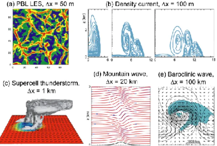
Fig. 2. Idealized simulations conducted with the ARW version of
WRF. (a) Horizontal cross-section of temperature fluctuations in a 3-D LES simulation of the PBL with a 50 m grid. (b) Potential tem-perature contours in a 2-D simulation of a density current with a 100 m grid at 5, 10, and 15 min. (c) Cloud field and surface tem-perature at one hour in a 3-D simulation of a splitting supercell in a horizontally homogeneous environment with a 1 km grid. (d) Potential temperature contours in a 2-D mountain-wave simulation with a 20 km grid without rotation. (e) Horizontal cross-section of surface temperature, winds, and condensed water (shaded) in a 3-D simlation of a baroclinic wave in a channel at 6 days with a 100 km grid.
convection-resolving model grids provides the opportunity to bypass the dilemma of cumulus parameterization, but raises numerous other issues that need to be addressed. These is-sues include: requirements for small-scale observations and data assimilation, refinements in model physics, and new ap-proaches for model verification. Recent investigations of convective-scale numerical forecasting have demonstrated the potential for improved forecasting of convective events, but also deficiencies related to the issues mentioned above (cf. Bernadet et al., 2000; Ducrocq et al., 2002; and Kotroni and Lagouvardos, 2004). We have begun testing the capabil-ities and limitations of WRF in forecasting convective events with horizontal grids of 4 km and below, relying on the ex-plicit treatment of convection, without cumulus parameteri-zation.
As part of this testing, we have conducted real-time fore-casts during the spring and early summer months in the cen-tral U.S. for the past three years. These forecasts were con-ducted with a 4 km horizontal grid over domains ranging from 2000×2000 km in 2003 to 3900×3000 km in 2005, centered over the central plains of the U.S. These fore-casts were conducted using explicit microphysics, with no cumulus parameterization. Although a 4 km grid is too coarse to resolve detailed aspects of convection, studies have shown the 4 km should be capable of resolving the major features of convective systems (cf. Weisman et al., 1997). Forecasts were initialized from 40 km Eta model analyses at 00:00 UTC each day and run out to 36 h. ARW fore-casts for these three spring/summer forecast experiments are
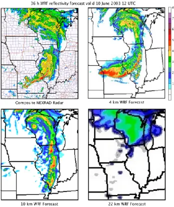
Fig. 3. 36 h WRF reflectivity forecast valid 10 June 2003 12:00 UTC. The 4 km forecast has no cumulus parameterization, while the 10 km and 22 km forecasts utilize the Kain-Fritsch cumu-lus parameterization. The composite NEXRAD radar reflectivity is included for comparison.
archived at: http://www.joss.ucar.edu/bamex/catalog (2003); http://www.joss.ucar.edu/wrf-2004/catalog (2004); and http: //www.joss.ucar.edu/wrf-2005/catalog (2005). Further de-tails of the model configuration are discussed by Done et al. (2004) and Weisman et al. (2004).
An illustration of the capabilities of the convection-resolving forecasts is displayed in Fig. 3, depicting the 36-hour 4 km WRF forecast for radar reflectivity valid on 10 June 2003 at 12:00 UTC. While there was little convective activity early in the forecast, a strong baroclinic system de-veloped during the forecast period, producing a concentrated line of convection extending across Illinois and Missouri at 36 h. At this resolution the cellular structure of the squall line is quite apparent. For comparison, forecasts are also included in Fig. 3 for 10 km and 22 km grids, both using a Kain-Fritsch cumulus parameterization. At 10 km, the structure and loca-tion of the squall line is noticeably degraded, while at 22 km, the line is not present in the resolved microphysics (although precipitation occurs in that area through the cumulus param-eterization).
During the 2003 forecast experiment, there was signifi-cant variation of the number of mesoscale convective sys-tems (MCSs) from day to day, as indicated in Fig. 4. The 4 km WRF forecasts captured this variability quite well, with a somewhat lower correlation in the 10 km forecasts. The superior behavior of the 4 km forecasts is reflected in the
Fig. 4. Time series for the number of MCSs forecast and observed
each day during the 2003 forecast experiment. The black line rep-resents the number observed MCSs, while the red and green lines represent the number of MCSs forecast with the 4 km and 10 km WRF, respectively (from Done et al., 2004).
Fig. 5. 24 h forecast for an intense squall line forming across Kansas
and Oklahoma at 00:00 UTC on 5 June 2005. Forecast reflectivity fields displayed for the 4 km WRF ARW (upper left), 2 km WRF ARW (lower left), and 4 km WRF NMM (upper right), together with the composite radar observations (posted at http://www.spc. noaa.gov/exper/Spring 2005/archive/20050429/).
anomaly correlation for each forecast time series with the ob-served series; the 4 km forecasts have a correlation of 0.57, while correlation for the 10 km forecasts is 0.35 (Done et al., 2004).
An example of a convective forecast from the 2005 pro-gram is shown in Fig. 5 for the case of an intense squall line that formed over Kansas and Oklahoma on 5 June 2005. The 4 km WRF ARW forecast accurately captures the timing, structure, and location of the line, as shown in the 24 h fore-cast. The University of Oklahoma was also conducting real-time forecasts during this experiment using a 2 km horizontal grid. These forecasts tended to be quite similar to the 4 km
28 J. B. Klemp: Advances in the WRF model for convection-resolving forecasting
Fig. 6. Track forecasts for Hurricane Katrina from a number of
models initialized at 00:00 UTC on 26 August 2005 (86 h prior to landfall – left panel) and at 00:00 UTC on 27 August 2005 (62 h prior to landfall – right panel). The location of landfall near the Louisiana-Mississippi border is indicated by the red triangle.
forecasts, but provided more details of the cellular convective structure (see Fig. 5). For comparison, the corresponding 24 h forecast from the WRF NMM is also displayed in Fig. 5; at this time the squall line is not yet well established as it developed slightly later in the NMM forecast.
Overall, these real-time experiments revealed surprising ability to forecast convective systems out to 36 h. In com-parison with coarser-grid forecasts, the 4 km WRF forecasts provided a much better indication of the likely mode of con-vection (bow echoes, mesoscale convective vortices, super-cell lines) as well as the timing and location of convective initiation. Beginning with coarse resolution (40 km) ini-tial data, we found that realistic convective scale structure spins up quickly over the first 6 h of the forecasts, consis-tent with the rapid development of kinetic energy at these scales documented by Skamarock (2004). The higher reso-lution forecasts also produced more accurate representation of gust fronts and system propagation, although there was occasional development of some spurious isolated convec-tion. There are some systematic biases in the forecasts in that they tend to overpredict precipitation and convective systems tend to decay more slowly than observed. However, the im-proved realism of the forecasts has provided significant value to forecasters, even for forecasts that do not exhibit improved quantitative accuracy in the timing and location of convec-tion. The convection resolving forecasts are quite sensitive to the microphysical parameterization used in the model, sug-gesting that this is an important area for further research in advancing storm-scale NWP.
4 Convection-resolving hurricane forecasting
High-resolution hurricane forecasts offer the opportunity to better resolve the eyewall structure and convective rainbands, and thereby improve the prediction of hurricane track and in-tensity. To assess the potential benefits of higher resolution, we have also conducted real-time forecasts with a 4 km grid
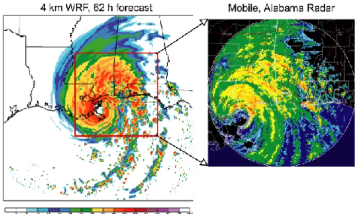
Fig. 7. Maximum radar reflectivity forecast in 4 km nested
mov-ing grid forecast at landfall 62 h after initialization at 00:00 UTC on 27 August 2005. The corresponding reflectivity from the Mobile, Alabama radar is displayed for the area indicated by the red box.
for hurricanes approaching landfall in the southeastern U.S. during the hurricane seasons in 2003–2005. For the 2005 season, we implemented a nested moving mesh in which a 4 km grid is nested within a larger outer 12 km grid and moves automatically to remain centered on the hurricane as determined by an a vortex tracking algorithm (Michalakes, et al., 2005). The moving nest provides a significant increase in computational efficiency by permitting a smaller nested domain needed to contain the hurricane during the forecast period.
Forecasts have been conducted for all of the major land-falling hurricanes during this period (Isabel in 2003; Charlie, Florence, Ivan in 2004; and Katrina, Rita, Wilma in 2005). These forecasts demonstrate highly realistic hurricane struc-tures, even for the major rainbands. The intensity and track forecasts are quite accurate, and the heavy precipitation is well represented, despite the simple microphysics.
Hurricane Katrina provides a good illustration of the per-formance of the high-resolution WRF hurricane forecasts. Katrina moved northward across the Gulf of Mexico as a category five hurricane, and came ashore near New Orleans on 29 August 2005 as a strong category three storm. The hurricane caused 1181 deaths and over $200 billion in dam-age, making Katrina the most expense natural disaster in U.S. history. The WRF forecasts were initialized from the 1/6 degree (approximately 18 km) GFDL analyses, and run with a 12 km grid until the hurricane was within three days of landfall, after which forecasts were initialized and run with the 4 km moving nest. Figure 6 displays track forecasts for WRF along with a number of operational models. The 12 km WRF forecast initialized on 26 August 00:00 UTC (86 h prior to landfall) predicted landfall near Mobile, Al-abama, about 150 km east of the actual location near the Louisiana-Mississippi border. At this time, however, other operational models were tracking significantly farther to the east, and the official forecast was estimating landfall in the middle portion of the Florida panhandle. By 00:00 UTC on 27 August (62 h prior to landfall), all of the model tracks had
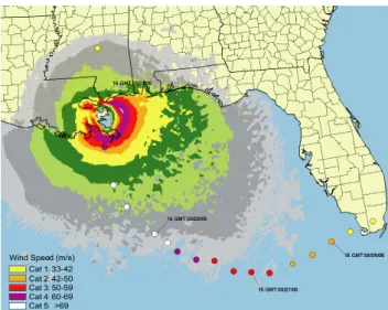
Fig. 8. Surface winds in the 4 km nested moving grid forecast at
landfall 62 h after initialization at 00:00 UTC on 27 August 2005. Colored circles represent the actual strength and location of the hur-ricane during the forecast period.
shifted significantly to the west; the 4 km WRF forecast, as well as most of the operational models, were in good agree-ment with the actual track.
Figure 7 displays the maximum reflectivity in the model forecast initialized on 27 August 00:00 UTC at the time of landfall at 62 h into the forecast. The overall distribution of precipitation agrees well with the observed reflectivity recorded by the radar at Mobile, Alabama at this time, with the heavy precipitation wrapping around the northern flank of the hurricane, and rainbands spiraling away from the hur-ricane to the southeast. This behavior is typical of other 4 km WRF hurricane forecasts, in which there is often remarkable correspondence between forecast and observed rainbands.
Hurricane Katrina reached category five strength crossing the central Gulf of Mexico (Fig. 8) and then decreased in strength, transitioning to category three as it came onshore. The WRF forecast hurricane intensified more slowly, reach-ing category 5 strength approachreach-ing landfall and rapidly de-creasing to category 3 as observed as Katrina came onshore. The eyewall diameter was somewhat larger than observed, a tendency also seen in other hurricane forecasts that requires further evaluation.
5 Summary
The convection-resolving WRF forecasts for hurricanes and mesoscale convective systems display realistic convective-scale features that provide a more accurate depiction of the structure and evolution of these systems. While these experimental forecasts demonstrate the potential for improved forecasts, significant challenges remain in seeking to fully realize that potential. Smaller scale features become increasingly important in high-resolution forecasts and little of this information is contained in convectional
verification techniques to evaluate model performance are required that properly assess the new kinds of information provided by these forecasts.
Edited by: V. Kotroni and K. Lagouvardos Reviewed by: anonymous referee
References
Bernardet, L. R., Grasso, L. D., Nachamkin, J. E., Finley, C. A., and Cotton, W. R.: Simulating convective events using a high-resolution mesoscale model, J. Geophys. Res., 105 , 14 963– 14 982, 2000.
Ducrocq, V., Ricard D., Lafore, J.-P., and Orain. F.: Storm-Scale Numerical Rainfall Prediction for Five Precipitating Events over France: On the Importance of the Initial Humidity Field, Wea. Forecasting, 17, 1236–1256, 2002.
Done, J., Davis, C., and Weisman, M. L.: The next generation of NWP: explicit forecasts of convection using the Weather Re-search and Forecasting (WRF) Model, Atmos. Sci. Lett., 5, 110– 117, 2004.
Kotroni, V. and Lagouvardos. K.: Evaluation of MM5 High-Resolution Real-Time Forecasts over the Urban Area of Athens, Greece, J. Appl. Meteor., 43, 1666–1678, 2004.
Michalakes, J., Dudhia, J., Gill, D., Henderson, T., Klemp, J., Ska-marock, W., and Wang, W.: The Weather Research and Fore-cast Model: Software Architecture and Performance, in: Pro-ceedings of the Eleventh ECMWRF Workshop on the Use of High Performance Computing in Meteorology, 25–29 October 2004, Reading, U.K., World Scientific, 156–168, available on-line: http://wrf-model.org/wrfadmin/publications.php, 2005. Skamarock, W. C.: Evaluating mesoscale NWP models using
ki-netic energy spectra, Mon. Wea. Rev., 132, 3019–3032, 2004. Skamarock, W. C., Klemp, J. B., Dudhia, J., Gill, D. O., Barker,
D. M., Wang, W., and Powers, J. G.,: A description of the Advanced Research WRF Version 2, NCAR Tech. Note TN-468+STR, 88 pp., available online: http://wrf-model.org/ wrfadmin/publications.php, 2005.
Weisman, M. L., Skamarock, W. C., and Klemp, J. B.: The Res-olution Dependence of Explicitly Modeled Convective Systems, Mon. Wea. Rev., 125, 527–548, 1997.
Weisman, M. L., Davis, C., and Done, J.: The promise and challenge of explicit convective forecasting with the WRF Model, Preprints, 22nd AMS Conference on Severe Local Storms, 4–8 October 2004, Hyannis, MA, 11 pp., available online: http://ams.confex.com/ams/11aram22sls/techprogram/ paper 81383.htm, 2004.