HAL Id: hal-00304265
https://hal.archives-ouvertes.fr/hal-00304265
Submitted on 13 Jun 2008HAL is a multi-disciplinary open access
archive for the deposit and dissemination of sci-entific research documents, whether they are pub-lished or not. The documents may come from teaching and research institutions in France or abroad, or from public or private research centers.
L’archive ouverte pluridisciplinaire HAL, est destinée au dépôt et à la diffusion de documents scientifiques de niveau recherche, publiés ou non, émanant des établissements d’enseignement et de recherche français ou étrangers, des laboratoires publics ou privés.
Limb scatter ozone retrieval from 10 to 60 km using a
Multiplicative Algebraic Reconstruction Technique
D. A. Degenstein, A. E. Bourassa, C. Z. Roth, E. J. Llewellyn
To cite this version:
D. A. Degenstein, A. E. Bourassa, C. Z. Roth, E. J. Llewellyn. Limb scatter ozone retrieval from 10 to 60 km using a Multiplicative Algebraic Reconstruction Technique. Atmospheric Chemistry and Physics Discussions, European Geosciences Union, 2008, 8 (3), pp.11853-11877. �hal-00304265�
ACPD
8, 11853–11877, 2008MART Limb Scatter Ozone Retrieval D. A. Degenstein et al. Title Page Abstract Introduction Conclusions References Tables Figures ◭ ◮ ◭ ◮ Back Close
Full Screen / Esc
Printer-friendly Version Interactive Discussion
Atmos. Chem. Phys. Discuss., 8, 11853–11877, 2008 www.atmos-chem-phys-discuss.net/8/11853/2008/ © Author(s) 2008. This work is distributed under the Creative Commons Attribution 3.0 License.
Atmospheric Chemistry and Physics Discussions
Limb scatter ozone retrieval from 10 to
60 km using a Multiplicative Algebraic
Reconstruction Technique
D. A. Degenstein1, A. E. Bourassa2, C. Z. Roth1, and E. J. Llewellyn1
1
Institute of Space and Atmospheric Studies, Saskatchewan, Canada
2
Science Systems and Applications, Inc., Hampton, VA, USA
Received: 12 March 2008 – Accepted: 4 May 2008 – Published: 13 June 2008 Correspondence to: D. A. Degenstein ([email protected])
ACPD
8, 11853–11877, 2008MART Limb Scatter Ozone Retrieval D. A. Degenstein et al. Title Page Abstract Introduction Conclusions References Tables Figures ◭ ◮ ◭ ◮ Back Close
Full Screen / Esc
Printer-friendly Version Interactive Discussion Abstract
The OSIRIS instrument onboard the Odin spacecraft routinely measures vertical pro-files of spectrally dispersed, limb scattered sunlight from the upper troposphere into the lower mesosphere. These measurements are used to retrieve the ozone number density vertical profile over the altitude range from 10 to 60 km using the SaskMART
5
Multiplicative Algebraic Reconstruction Technique, which is a one dimensional modifi-cation of an existing two-dimensional tomographic retrieval algorithm. This technique allows for the consistent merging of the absorption information from radiance measure-ments at wavelengths in the Chappuis and the Hartley-Huggins bands at each iteration of the inversion. The effectiveness of the retrieval is demonstrated using a set of
coin-10
cident SAGE II occultation measurements that show a mean bias of less than 2% from 18 to 53 km.
1 Introduction
In recent years multiple satellite instruments have been developed that measure the spectrum of limb scattered sunlight at ultraviolet, visible and near-infrared wavelengths.
15
The limb scatter data set allows for the retrieval of trace gas and aerosol profiles at a vertical resolution comparable to that of occultation measurements, but with signifi-cantly better global coverage. The first retrievals of ozone from satellite limb radiance measurements were made in the upper atmosphere by the Ultraviolet Spectrometer (UVS) on the Solar Mesospheric Explorer (SME) (Rusch et al.,1984). The
demonstra-20
tion flight instruments Shuttle Ozone Limb Sounding Experiment/Limb Ozone Retrieval Experiment (SOLSE/LORE) measured the limb radiance at several wavelengths in the Hartley-Huggins and Chappuis bands (McPeters et al.,2000). The vertical profile of the ozone density was retrieved from these measurements using normalized pair and triplet combinations of the radiances. The first routinely retrieved limb-scatter ozone
25
Sys-ACPD
8, 11853–11877, 2008MART Limb Scatter Ozone Retrieval D. A. Degenstein et al. Title Page Abstract Introduction Conclusions References Tables Figures ◭ ◮ ◭ ◮ Back Close
Full Screen / Esc
Printer-friendly Version Interactive Discussion
tem (OSIRIS) using a triplet combination of Chappuis band wavelengths to retrieve ozone densities from the troposphere up to 35 km (von Savigny et al.,2003). The Scan-ning Imaging Absorption Spectrometer for Atmospheric Cartography (SCIAMACHY) on Envisat (Bovensmann et al.,1999) is currently operational and routinely retrieves stratospheric/mesospheric ozone from limb radiance spectra in a similar fashion. The
5
Stratospheric Aerosol and Gas Experiment (SAGE) III primarily retrieves trace gas pro-files by solar occultation, but has the ability to measure the limb scatter radiances for retrieval of ozone and other species (Rault,2005). The limb scatter technique is to be used in an operational sense with the upcoming launch of Ozone Mapping and Profiler Suite (OMPS) on the NPOESS Preparatory Project (Flynn et al.,2004).
10
In this work we present a new technique for the retrieval of ozone vertical profiles from 10 to 60 km using limb scatter radiances measured by the OSIRIS instrument. A key feature of this algorithm is that it allows for the simultaneous merging of the informa-tion contained within the visible and ultraviolet ozone absorpinforma-tion bands in a consistent manner. This is done using a set of weighting factors that specify the importance of
15
each line of sight and each spectral measurement to the retrieval at each altitude of the profile. As part of this work, we introduce a methodology, based on the physics of the measurement, for the choosing of these weighting factors.
We demonstrate the success of this technique as applied to the OSIRIS measure-ments through comparison of these retrievals with near coincident SAGE II occultation
20
measurements.
2 The Measurements
The Canadian built OSIRIS instrument is onboard the Odin satellite and has been fully operational since shortly after launch on 21 February 2001. The spectrograph module measures the limb scattered sunlight dispersed over a wavelength range from
25
280 to 800 nm at 1 nm resolution. In normal operational mode, OSIRIS scans the limb from 7 to 70 km tangent altitude at approximately 0.75 km/s. The Odin orbit is
ACPD
8, 11853–11877, 2008MART Limb Scatter Ozone Retrieval D. A. Degenstein et al. Title Page Abstract Introduction Conclusions References Tables Figures ◭ ◮ ◭ ◮ Back Close
Full Screen / Esc
Printer-friendly Version Interactive Discussion
circular and sun-synchronous at an altitude near 600 km with a period of 96 min. The orbital inclination of 98 degrees from the equator provides near-global coverage as the corresponding sampled latitude range for nominal on-track instrument pointing is from 82 degrees S to 82 degrees N. The local time of the ascending node, i.e. the northward equatorial crossing, is 18:00 h. For more information on the Odin satellite and the
5
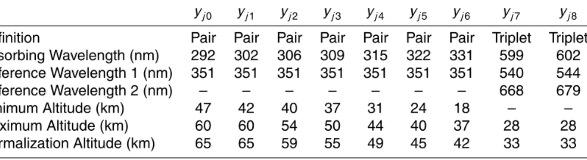
OSIRIS instrument seeMurtagh et al.(2002) andLlewellyn et al.(2004) respectively. This work presents a method for the retrieval of vertical ozone number density pro-files from OSIRIS limb radiance propro-files. Examples of the OSIRIS measurements from a typical limb scan are shown in Fig. 1 where the radiance is plotted as a function of tangent altitude. The left panel of the figure shows radiance profiles at selected
10
wavelengths within the Hartley-Huggins absorption band. The right panel shows three profiles from the Chappuis band absorption feature. The tangent altitude below which the limb radiance profile becomes roughly constant is known as the knee. This is the minimum altitude probed at that wavelength as it is the point where the optical depth becomes large. It is clear from Fig. 1 that the UV measurements sample lower
alti-15
tudes at longer wavelengths due to the decreasing ozone cross section, and that at the Chappuis wavelengths, it is still optically thin down to below 10 km.
The radiance profiles shown in Fig.1are combined to form the measurement vector. In a fashion similar to the technique employed byFlittner et al. (2000), measurement vector elements are formed using radiance profiles that are normalized at a reference
20
tangent altitude. In the Hartley-Huggins region, radiances are used in pairs defined as the difference between the logarithm of a normalized measurement at an absorbing wavelength, ˜I(j, λabs), and a similarly normalized measurement at a reference wave-length where the ozone absorption is very weak, ˜I(j, λref). Thus, the measurement
vector element is,
25
yj k = ln ˜I(j, λref) ˜I(j, λabs)
!
. (1)
ACPD
8, 11853–11877, 2008MART Limb Scatter Ozone Retrieval D. A. Degenstein et al. Title Page Abstract Introduction Conclusions References Tables Figures ◭ ◮ ◭ ◮ Back Close
Full Screen / Esc
Printer-friendly Version Interactive Discussion
tangent altitude, i.e. a line of sight. The measurement vector elements are indexed by two subscripts, j and k. Again, j represents a tangent altitude, and k is a number that represents a pair/triplet combination. For example, in this work we use seven pairs and two triplets such that k ranges from 0 to 8.
At Chappuis band wavelengths, triplets are formed as the difference between the
5
mean of the natural logarithm of two weakly absorbed normalized radiance profiles and the natural logarithm of the normalized radiance profile measured at a wavelength near the peak of the Chappuis cross section,
yj k = ln q ˜I(j, λref 1) ˜I(j, λref2) ˜I(j, λabs) . (2)
The two reference wavelengths are taken on either side of the peak absorption. A
10
summary of the measurement vector elements used in this work is provided in Table 1.
3 The SaskMART technique
The SaskMART technique is a type of Multiplicative Algebraic Reconstruction Tech-nique (MART) that iteratively updates the atmospheric state parameter using the ratio of observed and modelled measurement vector elements. In a fashion similar to a
non-15
linear relaxation technique (Chahine,1972), the sensitivity of the measurement vector to the state parameter must be positive; thus the pair and triplet definitions given above are the inverse of those used in previous work (e.g.Flittner et al.,2000;von Savigny
et al.,2003).
An important feature of the SaskMART algorithm is that more than one measurement
20
vector element can be used to retrieve the state parameter at any altitude. At each iteration, the multiplicative factor used to update the current atmospheric state at each altitude is a weighted average of all the ratios of observed and modelled measurement vector elements that are significant to the retrieved value.
ACPD
8, 11853–11877, 2008MART Limb Scatter Ozone Retrieval D. A. Degenstein et al. Title Page Abstract Introduction Conclusions References Tables Figures ◭ ◮ ◭ ◮ Back Close
Full Screen / Esc
Printer-friendly Version Interactive Discussion
3.1 Development
The SaskMART equation,
xi(n+1)= xi(n)X k X j ykjobs ykjmod Wkj i , (3)
has been presented in various forms in previous works (Degenstein et al., 2003;
De-genstein et al., 2004; Bourassa et al., 2007; Roth et al., 2007) associated with the
5
retrieval of geophysical quantities from OSIRIS radiance measurements. In this ap-plication, x(n)i is the ozone number density at an altitude denoted by i after the nth iteration. The observed and modelled measurement vectors are denoted by yj k, where j correponds to a tangent altitude element of the kth pair/triplet combination. The Wkj i terms in Eq. (3) are weighting factors that determine the importance of the kth
10
pair/triplet combination and the jthline of sight to the ozone density at the altitude i . At each altitude the sum over k and j of the weighting factors, Wkj i, is unity.
The line of sight and pair/triplet weighting factors terms can be considered indepen-dently such that Eq. (3) can also be written as,
xi(n+1)= xi(n)X k Wki X j ykjobs ykjmod Wj i , (4) 15
where the Wki term indicates the importance of the particular pair/triplet combination, k, to the retrieval at altitude i . The Wj i term allows more than one line of sight to contribute directly to the retrieved value at that altitude. Similarly, the summation of Wki over k and Wj i over j are both unity. This follows Roth et al. (2007), where the SaskMART equation is discussed in two distinct parts. The first part, corresponding to
ACPD
8, 11853–11877, 2008MART Limb Scatter Ozone Retrieval D. A. Degenstein et al. Title Page Abstract Introduction Conclusions References Tables Figures ◭ ◮ ◭ ◮ Back Close
Full Screen / Esc
Printer-friendly Version Interactive Discussion
the inner sum in Eq. (4),
αi k =X j ykjobs ykjmod Wj i , (5)
is defined for a single pair/triplet profile, i.e. a given k, and determines the ratio
αi k = x
(n+1)
i k
xi k(n)
. (6)
This ratio, αi k, is a multiplicative adjustment for iteratively updating xi based on
infor-5
mation from the kth pair/triplet only. The notation xi k is used to indicate this partial solution, which is for a given k, from the full solution that uses all pair/triplet combina-tions.
The second part of the SaskMART equation, the outer sum of Eq. (4), can then be written in terms of αi k as,
10
αi =X
k
(Wkiαi k) , (7)
where each multiplicative factor αi k is weighted by the importance of the k
th
pair/triplet for the retrieval at altitude i . Thus, αi is the final multiplicative value,
αi = x
(n+1)
i
xi(n)
, (8)
that is used to update the state parameter at each iteration.
15
3.2 Combining multiple lines of sight
In previous work by Roth et al. (2007), where only Chappuis band information was used, the authors found it sufficient to allow three lines of sight, corresponding to suc-cessively lower tangent altitudes, to influence the retrieval at any given altitude. We
ACPD
8, 11853–11877, 2008MART Limb Scatter Ozone Retrieval D. A. Degenstein et al. Title Page Abstract Introduction Conclusions References Tables Figures ◭ ◮ ◭ ◮ Back Close
Full Screen / Esc
Printer-friendly Version Interactive Discussion
also follow this approach in this work such that elements Wi j in Eq. (4) are non-zero only if j represents the line of sight tangent through altitude i or the next two succes-sively lower tangent altitudes. Likewise, we have followed the convention ofRoth et al.
(2007) and assigned Wi ,i a weight of 0.6, Wi ,i −1a weight of 0.3 and Wi ,i −2a weight of 0.1 as these roughly correspond to normalized values from the path length matrix.
5
3.3 Combining multiple pairs and triplets
As discussed in Sect.2, in the limb geometrydifferent wavelengths probe different al-titude ranges based on the optical depth along the line of sight. At absorbing wave-lengths, this is primarily a function of the strength of the ozone cross section. In com-bining multiple pairs and triplets for the retrieval, it is important that each measurement
10
contributes only over the altitude range where lines of sight have a relatively large sen-sitivity to ozone. Based on this, we have developed a straight forward methodology for determining the altitude range over which each pair/triplet has non-zero weighting in the inversion.
The minimum altitude for each Hartley-Huggins band pair is determined by the
lo-15
cation of the knee in the radiance profile of the absorbing wavelength (it is assumed that the knee in the reference wavelengths is below this altitude). The knee altitude is a somewhat weak function of the ozone profile; however, it is sufficient to choose an altitude corresponding to an average profile. Because there is no knee in the ra-diance profiles in the Chappuis band from 10 to 60 km, the minimum altitude of the
20
two triplets we use in this work is set to 10 km, i.e. the lower retrieval boundary. The minimum altitude of the pairs formed from Hartley-Huggins band radiances decreases with wavelength from 47 km at 292 nm to 18 km at 331 nm. All values are summarized in Table 1. The normalization tangent altitude of the Chappuis band triplets is set at 33 km. At this altitude the ozone absorption is becoming significantly weak. As well,
25
there is some potential for contamination from low signal to noise and stray light at these wavelengths above this altitude. The Hartley-Huggins band pairs are normal-ized at successively higher tangent altitudes such that the maximum value of the pair,
ACPD
8, 11853–11877, 2008MART Limb Scatter Ozone Retrieval D. A. Degenstein et al. Title Page Abstract Introduction Conclusions References Tables Figures ◭ ◮ ◭ ◮ Back Close
Full Screen / Esc
Printer-friendly Version Interactive Discussion
which occurs at the minimum altitude, is approximately 1.0. In an approximate sense, this represents a distance of one optical depth from the normalization altitude to the minimum altitude. The important effect of this scaling is that systematic errors in the for-ward model are minimized by using a normalization tangent altitude near the retrieval points. Again, see Table 1 for a full list of the normalization altitudes.
5
Finally, the maximum altitude for which each pair/triplet has a non-zero weight is cho-sen as 5 km below the normalization tangent altitude. It is important that the pair/triplet is not used in close proximity to the normalization because, by definition, the pairs and triplets, and hence the sensitivity, approach zero at the normalization point. As well, because the MART iterations are based on the ratio of the observed and modelled
10
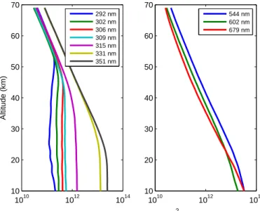
measurement vectors, it is wise to avoid the division of two small numbers in consid-eration of the noise that will be present in the observation. Fig.2 shows the pair and triplet values constructed from the OSIRIS radiances shown in Fig.1. The pairs using absorbing wavelengths at 292, 302, 306, 309, 315, and 322 nm profiles increase from zero at the normalization tangent altitude to a value near 1.0 at the minimum altitude.
15
Two Chappuis band triplets are used in the retrieval but they are almost indistinguish-able on this plot so only one is shown.
The pair constructed using the 331 nm radiance profile was chosen in a similar fash-ion; however as the ozone cross section is significantly weaker at this wavelength, the location of the knee is not as obvious. We have chosen 18 km as the minimum altitude
20
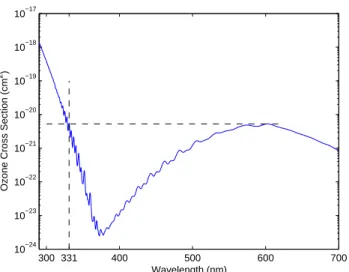
for this pair. This creates significant overlap between the region that the Chappuis and Huggins band information is being used and is of great benefit for the consistency of the inversion in the transition region between the visible and ultraviolet wavelengths. The sensitivity of the 331 nm radiance to ozone at these low altitude is still significant. In fact, as shown in Fig.3, the value of the Huggins band cross section at 331 nm is
25
very similar to the peak of the absorption in the Chappuis band. The similar nature of the ozone sensitivity at these two wavelengths is reflected in the comparable shapes of the profile of the 331 nm pair and the Chappuis triplet shown in Fig.2. Because the cross section at this wavelength is significantly less than for the other Hartley-Huggins
ACPD
8, 11853–11877, 2008MART Limb Scatter Ozone Retrieval D. A. Degenstein et al. Title Page Abstract Introduction Conclusions References Tables Figures ◭ ◮ ◭ ◮ Back Close
Full Screen / Esc
Printer-friendly Version Interactive Discussion
wavelengths that are used, the normalization altitude was chosen at 42 km to limit the contribution to an altitude range of approximately 20 km.
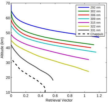
3.4 Setting the weighting factors
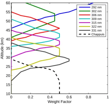
As explained in the previous section, the information from each pair and triplet shown in Fig.2is used for the retrieval over different, overlapping altitude ranges. The
weight-5
ing factors, Wi k, in the SaskMART algorithm specify the relative contribution of each pair/triplet, k, as a function of altitude, where at each altitude, i , the sum of the weight-ing factors over k must equal unity. As part of this work we have found that it is impor-tant that the contribution from each pair/triplet is increased and decreased slowly over an altitude range so that small systematic errors in the forward model that vary with
10
wavelength and altitude do not cause oscillatory structure in the retrieved profile. Thus the weighting factor for each pair/triplet is increased slowly from zero at the minimum altitude to the altitude where it has maximum significance for the retrieval and then slowly decreased to zero at the maximum altitude. For the highest altitude pair and the lowest altitude triplets the weighting factor is largest at the upper and lower retrieval
15
boundary respectively. Fig.4is a plot of the weighting factors assigned to each of the pair and triplets used in this work. To create these weighting factors, we have used a roughly linear trend over 5–8 km to increase and decrease the weighting factor in each case from the minimum and maximum altitudes, while maintaining a unity sum of the weighting factors at each altitude. A second consideration in the creation of these
20
weighting factors was to use information from at least three pairs or triplets at each altitude. Again the upper and lower boundaries are a special case. It is important to note that these factors do not have any direct mathematical relationship to either the averaging kernel or the Jacobian matrix.
We should also note that we have found, through significant testing, that it is possible
25
to use similar, yet different weighting factors with very minimal impact on the retrieved solution. Especially in the case of an instrument with lower signal to noise, the addition of more pairs and triplets is certainly a good idea and a new of set weighting factors
ACPD
8, 11853–11877, 2008MART Limb Scatter Ozone Retrieval D. A. Degenstein et al. Title Page Abstract Introduction Conclusions References Tables Figures ◭ ◮ ◭ ◮ Back Close
Full Screen / Esc
Printer-friendly Version Interactive Discussion
can be determined using the same methodology. The weighting factors presented in this work are a sample set that is sufficient for use with the OSIRIS measurements.
4 Implementation details
4.1 The radiative transfer model
The radiative transfer model used in this work for the forward simulation of the limb
5
radiances used to construct the measurement vector pair and triplet elements is the SASKTRAN model (Bourassa et al.,2008). SASKTRAN is a spherical shell, arbitrary order multiple scatter model that simulates the effects of absorbing gases and strato-spheric sulphate aerosols on the propagation of uv-visible radiation through the atmo-sphere. The SASKTRAN model has been demonstrated byBourassa et al.(2008) to
10
agree well with the other similar models compared byLoughman et al. (2004). The ozone cross section used in SASKTRAN for this work is from Burrows et al.(1999). For the results presented in this paper the order of the multiple scatter calculation is limited to three scattering events, which is more than sufficient for the altitudes and wavelengths that are considered.
15
4.2 The retrieval grid
The OSIRIS instrument scans the limb at a relatively constant rate; however, the auto-exposure algorithm of the spectrograph achieves high signal to noise at low tangent altitude with short exposure times such that the spacing of the measured spectra is closer in tangent altitude near the bottom of the scan. Typically the spacing ranges from
20
1.0 km at low tangent altitude to 2.5 km at upper tangent altitudes. In the SaskMART algorithm the altitudes at which the update factor αi is calculated correspond directly
to the tangent altitudes of the lines of sight, j , in the OSIRIS scan.
Therefore, after each iteration of the SaskMART equation the ozone profile in the SASKTRAN model is updated by interpolating αi as function of altitude to the
ACPD
8, 11853–11877, 2008MART Limb Scatter Ozone Retrieval D. A. Degenstein et al. Title Page Abstract Introduction Conclusions References Tables Figures ◭ ◮ ◭ ◮ Back Close
Full Screen / Esc
Printer-friendly Version Interactive Discussion
TRAN shell altitudes and multiplying the ozone profile at these shell altitudes by the interpolated value of αi. Furthermore, the multiplicative factor used for the highest re-trieved altitude is applied to the profile at all altitudes above this point. Similarly, the multiplicative factor used for the lowest retrieved altitude is applied for all points below this altitude. For this work, SASKTRAN vertical shell spacing is 1 km and the altitude
5
range extends from 0 to 100 km. 4.3 Other parameters
It has been shown in previous workthat the limb scatter ozone retrieval is dependent on knowledge of the stratospheric aerosol profile and the NO2 profile. The sulphate aerosol number density profiles used in the SASKTRAN model have been retrieved
10
using the OSIRIS data with the technique outlined inBourassa et al.(2007). The NO2
number density was also retrieved from the OSIRIS data using a method based on the SaskMART algorithm. Details of the NO2retrieval will be presented in a future work.
A basic cloud detection algorithm is implemented using a long wavelength channel. The presence of a cloud top above 10 km altitude defines the lower boundary of the
15
inversion. Also, a retrieval of the effective albedo is performed for each scan, see
Bourassa et al.(2007). For this implementation, the initial guess ozone profile is taken from a standard climatology (McPeters et al.,1997).
4.4 A note on the error analysis
There have been recent papers that have addressed the sensitivity analysis of limb
20
scattering ozone retrieval (e.g.Loughman et al.,2005) and those results, e.g. the ef-fects of albedo, aerosol, pointing, etc., are also valid for the SaskMART inversion tech-nique and need not be repeated here. More specifically, however, a methodology for performing a formal error analysis for the SaskMART technique has been presented in
Roth et al.(2007) andBourassa et al.(2007) using a numerical perturbation technique
25
tech-ACPD
8, 11853–11877, 2008MART Limb Scatter Ozone Retrieval D. A. Degenstein et al. Title Page Abstract Introduction Conclusions References Tables Figures ◭ ◮ ◭ ◮ Back Close
Full Screen / Esc
Printer-friendly Version Interactive Discussion
nique are very similar to those presented inRoth et al.(2007); however, the addition of the ultraviolet wavelength information keeps the uncertainty due to the measure-ment noise below approximately 5% up to 55 km altitude. The effect of the initial guess and the number of iterations are nearly identical to the results presented inRoth et al.
(2007).
5
5 Results: SAGE II comparisons
In order to evaluate this inversion technique as applied to the OSIRIS data, we have selected a set of coincidences between OSIRIS limb scans and Stratospheric Aerosol and Gas Experiment (SAGE) II occultation events. For a description of the SAGE II data set see, for example, Cunnold et al. (1989), Chu et al. (1989), andMcCormick
10
et al. (1989). The coincidence set spans the almost four year mission overlap, from 2001 to 2005, and includes 196 events that are within 200 km and 2 h. The locations of the measurements are relatively well distributed over both hemispheres, from 20 to 80◦latitude, and are limited to solar zenith angles at the OSIRIS tangent point that are
less than 88◦. Coincidences in the tropics do not occur with these tight criteria.
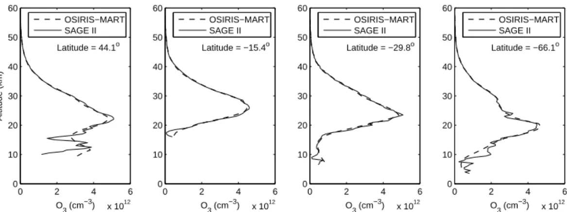
15
Figure5shows the SAGE II and OSIRIS SaskMART ozone profiles for a sample of four of these coincidences. These results are very typical and were chosen specifically at different latitudes to demonstrate the similarity in the structure of the retrieved profiles from the two instruments. It should also be noted that the OSIRIS retrievals appear to be very consistent through the 20 to 40 km altitude region where the information in the
20
inversion transitions from visible to ultraviolet wavelengths.
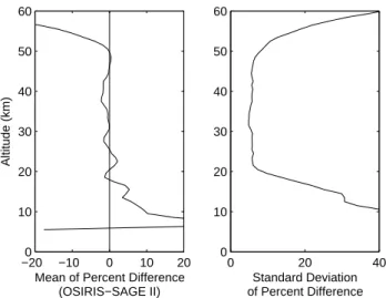
The statistics that were generated using all 196 profiles in the coincidence set are shown in Fig.6. For this comparison, the SAGE II profiles are convolved to 2 km resolu-tion to better match the OSIRIS vertical resoluresolu-tion and interpolated to the 1 km OSIRIS retrieval grid. The left panel in the figure shows the mean of the percent difference from
25
each coincidence and, between 18 and 53 km, it is less than 2%. Variability in time and space is likely the cause of the larger bias below 18 km. The standard deviation of the
ACPD
8, 11853–11877, 2008MART Limb Scatter Ozone Retrieval D. A. Degenstein et al. Title Page Abstract Introduction Conclusions References Tables Figures ◭ ◮ ◭ ◮ Back Close
Full Screen / Esc
Printer-friendly Version Interactive Discussion
percent difference from each coincidence is shown in the right panel of the figure and it is approximately a consistent 5% from 20 to 50 km. Again, it is important to note that the transitions between wavelengths in the inversion as a function of altitude do not appear in the mean bias or in the standard deviation in these comparisons with SAGE II.
5
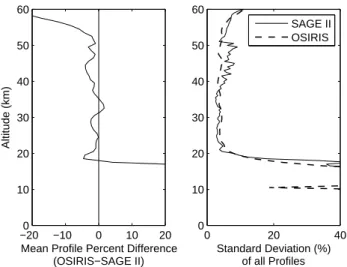
The retrievals at tropical latitudes were compared in a zonal average sense due to the rare time and space coincidence between the two instruments in this region. Over a 24 h period beginning on 10 October 2003, 15 SAGE II events and 26 OSIRIS scans fall in a latitude band between 16 and 21◦N. The left panel of Fig.7shows the percent
difference between the mean profile measured by each instrument. The right panel
10
shows the standard deviation of the profiles as an indication of the measured variabil-ity. The results are similar to the previous case with a mean bias of less than 5% from 20 to 50 km. It is likely that the agreement does not extend quite as low in this case due to the higher altitude of the tropical tropopause. This can certainly also been seen in the sharp increase in the variability of the profiles below 20 km. Overall, the
15
variability of the measured profiles is very similar between the two instrument from 20 to 50 km. However, the slight increase in the SAGE II results as altitude approaches 50 km does not appear in the OSIRIS measurements. Once more the transition be-tween the Chappuis and Hartley-Huggins band absorption information in the OSIRIS retrievals does not appear as a systematic bias or as an increase in the variability of
20
the measurements.
6 Conclusions
The SaskMART technique provides a method for the retrieval of vertical profiles of ozone from limb scattered sunlight spectra that allows for the consistent incorporation of information from the Chappuis and Hartley-Huggins band absorption features as a
25
function of altitude. A set of weighting factors is used to determine the importance of each line of sight and each element of the measurement vector for the retrieved
ACPD
8, 11853–11877, 2008MART Limb Scatter Ozone Retrieval D. A. Degenstein et al. Title Page Abstract Introduction Conclusions References Tables Figures ◭ ◮ ◭ ◮ Back Close
Full Screen / Esc
Printer-friendly Version Interactive Discussion
state at each altitude. The application of the technique to the measurements made by the OSIRIS instrument demonstrates agreement with coincident SAGE II occultation measurements to within 2% from 18 to 53 km altitude over a large range of geolocations and solar zenith angles.
This retrieval is regularly processed at the University of Saskatchewan for all OSIRIS
5
stratospheric limb scan measurements. Data from November, 2001, to the current date is available for download as an OSIRIS Level 2 Product in HDF-EOS5 format. OSIRIS remains fully operational and processing of this algorithm will be maintained into the foreseeable future.
Acknowledgements. This work was supported by the Natural Sciences and Engineering
Re-10
search Council (Canada) and the Canadian Space Agency. Odin is a Swedish-led satellite project funded jointly by Sweden (SNSB), Canada (CSA), France (CNES) and Finland (Tekes).
References
Bourassa, A. E., Degenstein, D. A., Gattinger, R. L., and Llewellyn, E. J.: Stratospheric aerosol retrieval with OSIRIS limb scatter measurements, J. Geophys. Res., 112, D10217, doi:10.
15
1029/2006JD008079, 2007.11858,11864
Bourassa, A. E., Degenstein, D. A., and Llewellyn, E. J.: SASKTRAN: A spherical geometry radiative transfer code for efficient estimation of limb scattered sunlight, J. Quant. Spectros.
Ra., 109, 52–73, 2008. 11863
Bovensmann, H., Burrows, J. P., Buchwitz, M., Frerick, J., No ¨el, S., Rozanov, V. V., Chance,
20
K. V., and Goede, A. P. H.: SCIAMACHY: Mission Objectives and Measurement Modes, J.
Atmos. Sci., 56, 127–150, 1999. 11855
Burrows, J. P., Richter, A., Dehn, A., Deters, B., Himmelmann, S., Voigt, S., and Orphal, J.: Atmospheric remote sensing reference data from GOME-2, Temperature dependent
absorp-tion cross secabsorp-tions of O3 in the 234–794 nm range, J. Quant. Spectrosc. Ra., 61, 509–519,
25
1999. 11863
Chahine, M. T.: A General Relaxation Method for Inverse Solution of the Full Radiative Transfer
ACPD
8, 11853–11877, 2008MART Limb Scatter Ozone Retrieval D. A. Degenstein et al. Title Page Abstract Introduction Conclusions References Tables Figures ◭ ◮ ◭ ◮ Back Close
Full Screen / Esc
Printer-friendly Version Interactive Discussion Chu, W. P., McCormick, M. P., Lenoble, J., Brogniez, C., and Pruvost, P.: SAGE II inversion
algorithm, J. Geophys. Res., 94, 8339–8351, 1989. 11865
Cunnold, D. M., Chu, W. P., McCormick, M. P., Veiga, R. E., and Barnes, R. A.: Validation of
SAGE II ozone measurements, J. Geophys. Res., 94, 8447–8460, 1989. 11865
Degenstein, D. A., Llewellyn, E. J., and Lloyd, N. D.: Volume emission rate tomography from a
5
satellite platform, Appl. Optics, 42, 1441–1450, 2003. 11858
Degenstein, D. A., Llewellyn, E. J., and Lloyd, N. D.: Tomographic retrieval of the oxygen infrared atmospheric band with the OSIRIS infrared imager, Can. J. Phys., 82, 501–515,
2004. 11858
Flittner, D. E., Bhartia, P. K., and Herman, B. M.: O3 profiles retrieved from limb scatter
10
measurements: Theory, Geophys. Res. Lett., 27, 2601–2604, doi:10.1029/1999GL011343,
2000. 11856,11857
Flynn, L. E., Homstein, J., and Hilsenrath, E.: The ozone mapping and profiler suite (OMPS). The next generation of US ozone monitoring instruments, in: Proceedings Quadrennial
Ozone Symposium, edited by: Zerefos, C., 538–539, 2004. 11855
15
Llewellyn, E. J., Lloyd, N. D., Degenstein, D. A., Gattinger, R. L., Petelina, S. V., Bourassa, A. E., Wiensz, J. T., Ivanov, E. V., McDade, I. C., Solheim, B. H., McConnell, J. C., Haley, C. S., von Savigny, C., Sioris, C. E., McLinden, C. A., Griffioen, E., Kaminski, J., Evans, W. F., Puckrin, E., Strong, K., Wehrle, V., Hum, R. H., Kendall, D. J. W., Matsushita, J., Murtagh, D. P., Brohede, S., Stegman, J., Witt, G., Barnes, G., Payne, W. F., Pich ´e, L., Smith, K., Warshaw,
20
G., Deslauniers, D.-L., Marchand, P., Richardson, E. H., King, R. A., Wevers, I., McCreath, W., Kyr ¨ol ¨a, E., Oikarinen, L., Leppelmeier, G. W., Auvinen, H., M ´egie, G., Hauchecorne, A., Lef `evre, F., de La N ¨oe, J., Ricaud, P., Frisk, U., Sjoberg, F., von Sch ´eele, F., and Nordh, L.:
The OSIRIS instrument on the Odin spacecraft, Can. J. Phys., 82, 411–422, 2004. 11856
Loughman, R. P., Griffioen, E., Oikarinen, L., Postylyakov, O. V., Rozanov, A., Flittner, D. E.,
25
and Rault, D. F.: Comparison of radiative transfer models for limb-viewing scattered sunlight
measurements, J. Geophys. Res., 109, doi:10.1029/2003JD003854, 2004. 11863
Loughman, R. P., Flittner, D. E., Herman, B. M., Bhartia, P. K., Hilsenrath, E., and McPeters, R. D.: Description and sensitivity analysis of a limb scattering ozone retrieval algorithm, J.
Geophys. Res., 110, D19301, doi:10.1029/2004JD005429, 2005.11864
30
McCormick, M. P., Zawodny, J. M., Veiga, R. E., Larsen, J. C., and Wang, P. H.: An overview of
sage I and II ozone measurements, Plan. Sp. Sci., 37, 1567–1586, 1989. 11865
ACPD
8, 11853–11877, 2008MART Limb Scatter Ozone Retrieval D. A. Degenstein et al. Title Page Abstract Introduction Conclusions References Tables Figures ◭ ◮ ◭ ◮ Back Close
Full Screen / Esc
Printer-friendly Version Interactive Discussion balloonsonde estimation of total column ozone, J. Geophys. Res., 102, 8875–8886, doi:
10.1029/96JD02977, 1997.11864
McPeters, R. D., Janz, S. J., Hilsenrath, E., Brown, T. L., Flittner, D. E., and Heath, D. F.: The
retrieval of O3profiles from limb scatter measurements: Results from the Shuttle Ozone Limb
Sounding Experiment, Geophys. Res. Lett., 27, 2597–2600, doi:10.1029/1999GL011342,
5
2000. 11854
Murtagh, D., Frisk, U., Merino, F., Ridal, M., Jonsson, A., Stegman, J., Witt, G., Eriksson, P., Jim ´enez, C., Megie, G., de La No ¨e, J., Ricaud, P., Baron, P., Pardo, J. R., Hauchcorne, A., Llewellyn, E. J., Degenstein, D. A., Gattinger, R. L., Lloyd, N. D., Evans, W. F. J., McDade, I. C., Haley, C. S., Sioris, C., von Savigny, C., Solheim, B. H., McConnell, J. C., Strong, K.,
10
Richardson, E. H., Leppelmeier, G. W., Kyr ¨ol ¨a, E., Auvinen, H., and Oikarinen, L.: Review:
An overview of the Odin atmospheric mission, Can. J. Phys., 80, 309–319, 2002. 11856
Rault, D. F.: Ozone profile retrieval from Stratospheric Aerosol and Gas Experiment (SAGE III) limb scatter measurements, J. Geophys. Res., 110, doi:10.1029/2004JD004970, 2005.
11855
15
Roth, C., Degenstein, D., Bourassa, A., and Llewellyn, E.: The retrieval of vertical profiles of the ozone number density using Chappuis band absorption information and a multiplicative
algebraic reconstruction technique, Can. J. Phys., 85, 1225–1243, 2007. 11858, 11859,
11860,11864,11865
Rusch, D. W., Mount, G. H., Barth, C. A., Thomas, R. J., and Callan, M. T.: Solar mesospheric
20
explorer ultraviolet spectrometer: Measurements of ozone in the 1.0–0.1 mbar region, J.
Geophys. Res., 89, 11 677–11 687, 1984. 11854
von Savigny, C., Haley, C. S., Sioris, C. E., McDade, I. C., Llewellyn, E. J., Degenstein, D., Evans, W. F. J., Gattinger, R. L., Griffioen, E., Kyr ¨ol ¨a, E., Lloyd, N. D., McConnell, J. C., McLinden, C. A., M ´egie, G., Murtagh, D. P., Solheim, B., and Strong, K.: Stratospheric ozone
25
profiles retrieved from limb scattered sunlight radiance spectra measured by the OSIRIS instrument on the Odin satellite, Geophys. Res. Lett., 30, doi:10.1029/2002GL016401, 2003.
ACPD
8, 11853–11877, 2008MART Limb Scatter Ozone Retrieval D. A. Degenstein et al. Title Page Abstract Introduction Conclusions References Tables Figures ◭ ◮ ◭ ◮ Back Close
Full Screen / Esc
Printer-friendly Version Interactive Discussion
Table 1. Definitions of the 9 pair/triplet combinations calculated from the measured limb
radi-ances shown in Fig.1that are used to construct the measurement vector, yj k.
yj0 yj1 yj2 yj3 yj4 yj5 yj6 yj7 yj8
Definition Pair Pair Pair Pair Pair Pair Pair Triplet Triplet
Absorbing Wavelength (nm) 292 302 306 309 315 322 331 599 602 Reference Wavelength 1 (nm) 351 351 351 351 351 351 351 540 544 Reference Wavelength 2 (nm) – – – – – – – 668 679 Minimum Altitude (km) 47 42 40 37 31 24 18 – – Maximum Altitude (km) 60 60 54 50 44 40 37 28 28 Normalization Altitude (km) 65 65 59 55 49 45 42 33 33
ACPD
8, 11853–11877, 2008MART Limb Scatter Ozone Retrieval D. A. Degenstein et al. Title Page Abstract Introduction Conclusions References Tables Figures ◭ ◮ ◭ ◮ Back Close
Full Screen / Esc
Printer-friendly Version Interactive Discussion 1010 1012 1014 10 20 30 40 50 60 70 Altitude (km)
Limb Radiance (photons/s/cm2/nm/sterad)
292 nm 302 nm 306 nm 309 nm 315 nm 331 nm 351 nm 1010 1012 1014 10 20 30 40 50 60 70 544 nm 602 nm 679 nm
Fig. 1. A sample set of OSIRIS limb radiance profiles used for the ozone retrieval.
Measure-ments within the Hartley-Huggins band and Chappuis band are shown in the left and right panels, respectively.
ACPD
8, 11853–11877, 2008MART Limb Scatter Ozone Retrieval D. A. Degenstein et al. Title Page Abstract Introduction Conclusions References Tables Figures ◭ ◮ ◭ ◮ Back Close
Full Screen / Esc
Printer-friendly Version Interactive Discussion 0 0.2 0.4 0.6 0.8 1 1.2 10 20 30 40 50 60 70 Retrieval Vector Altitude (km) 292 nm 302 nm 306 nm 309 nm 315 nm 322 nm 331 nm Chappuis
Fig. 2. A sample set of the 9 OSIRIS pair/triplet measurement vector elements used in the
ozone retrieval. See Table 1 for complete definitions. Values of the two Chappuis triplets are indistinguishable in this plot.
ACPD
8, 11853–11877, 2008MART Limb Scatter Ozone Retrieval D. A. Degenstein et al. Title Page Abstract Introduction Conclusions References Tables Figures ◭ ◮ ◭ ◮ Back Close
Full Screen / Esc
Printer-friendly Version Interactive Discussion 300 331 400 500 600 700 10−24 10−23 10−22 10−21 10−20 10−19 10−18 10−17
Ozone Cross Section (cm
2)
Wavelength (nm)
ACPD
8, 11853–11877, 2008MART Limb Scatter Ozone Retrieval D. A. Degenstein et al. Title Page Abstract Introduction Conclusions References Tables Figures ◭ ◮ ◭ ◮ Back Close
Full Screen / Esc
Printer-friendly Version Interactive Discussion 0 0.2 0.4 0.6 0.8 1 10 15 20 25 30 35 40 45 50 55 60 Weight Factor Altitude (km) 292 nm 302 nm 306 nm 309 nm 315 nm 322 nm 331 nm Chappuis
ACPD
8, 11853–11877, 2008MART Limb Scatter Ozone Retrieval D. A. Degenstein et al. Title Page Abstract Introduction Conclusions References Tables Figures ◭ ◮ ◭ ◮ Back Close
Full Screen / Esc
Printer-friendly Version Interactive Discussion 0 2 4 6 x 10¹² 0 10 20 30 40 50 60 O 3 (cm −3) Altitude (km) Latitude = 44.1o OSIRIS−MART SAGE II 0 2 4 6 x 10¹² 0 10 20 30 40 50 60 O 3 (cm −3) Latitude = −15.4o OSIRIS−MART SAGE II 0 2 4 6 x 10¹² 0 10 20 30 40 50 60 O 3 (cm −3) Latitude = −29.8o OSIRIS−MART SAGE II 0 2 4 6 x 10¹² 0 10 20 30 40 50 60 O 3 (cm −3) Latitude = −66.1o OSIRIS−MART SAGE II
Fig. 5. A selection of single profiles that meet the coincidence criteria. Profiles are shown at
ACPD
8, 11853–11877, 2008MART Limb Scatter Ozone Retrieval D. A. Degenstein et al. Title Page Abstract Introduction Conclusions References Tables Figures ◭ ◮ ◭ ◮ Back Close
Full Screen / Esc
Printer-friendly Version Interactive Discussion −200 −10 0 10 20 10 20 30 40 50 60
Mean of Percent Difference (OSIRIS−SAGE II) Altitude (km) 0 20 40 0 10 20 30 40 50 60 Standard Deviation of Percent Difference
Fig. 6. The mean and standard deviation of the percent differences between the retrieved
ACPD
8, 11853–11877, 2008MART Limb Scatter Ozone Retrieval D. A. Degenstein et al. Title Page Abstract Introduction Conclusions References Tables Figures ◭ ◮ ◭ ◮ Back Close
Full Screen / Esc
Printer-friendly Version Interactive Discussion −200 −10 0 10 20 10 20 30 40 50 60
Mean Profile Percent Difference (OSIRIS−SAGE II) Altitude (km) 0 20 40 0 10 20 30 40 50 60 Standard Deviation (%) of all Profiles SAGE II OSIRIS
Fig. 7. The percent difference of the zonal average profile measured by OSIRIS and SAGE II
over 24 h for a 5◦ tropical latitude band (15 SAGE II measurements and 26 OSIRIS