Coordinated Planning of Air and Space Assets: An
Optimization and Learning Based Approach
by
Eric John Robinson
B.S. Mathematics, United States Air Force Academy (2011)
Submitted to the Sloan School of Management
in partial fulfillment of the requirements for the degree of
Master of Science in Operations Research
at the
MASSACHUSETTS INSTITUTE OF TECHNOLOGY
June 2013
This material is a declared work of the U.S. Government and is not subject to
copyright protection in the United States.
Author . . . .
Sloan School of Management
May 17, 2013
Approved by . . . .
Mark Abramson
Member of the Technical Staff
The Charles Stark Draper Laboratory
Technical Supervisor
Certified by . . . .
Hamsa Balakrishnan
Associate Professor of Aeronautics and Astronautics
Thesis Supervisor
Accepted by . . . .
Professor Dimitris J. Bertsimas
Boeing Professor of Operations Research
Co-director, Operations Research Center
This thesis was prepared at The Charles Stark Draper Laboratory, Inc. under Grant Num-ber NNX12H81G sponsored by the National Aeronautics and Space Administration Earth Science Technology Office Advanced Information Systems Technology-11 program.
Publication of this thesis does not constitute approval by Draper or the sponsoring agency of the findings or conclusions contained herein. It is published for the exchange and stimulation of ideas.
The views expressed in this article are those of the author and do not reflect the official policy or position of the United States Air Force, Department of Defense, or the U.S. Government.
Coordinated Planning of Air and Space Assets: An Optimization
and Learning Based Approach
by
Eric John Robinson
Submitted to the Sloan School of Management on May 17, 2013, in partial fulfillment of the
requirements for the degree of Master of Science in Operations Research
Abstract
There are many organizations that use unmanned assets, such as satellites or drones, to collect information. This may include taking pictures of the ground, gathering infrared pho-tos, taking atmospheric pressure measurements, or any conceivable form of data collection. Often these separate organizations have overlapping collection interests or flight plans that are sending sensors into similar regions. However, they tend to be controlled by separate planning systems which operate on asynchronous scheduling cycles. We present a method for coordinating various collection tasks between the planning systems in order to vastly increase the utility that can be gained from these assets. This method focuses on allocation of collection requests to scheduling systems rather than complete centralized planning over the entire system so that the current planning infrastructure can be maintained without changing any aspects of the schedulers. We expand on previous work in this area by inclu-sion of a learning method to capture information about the uncertainty pertaining to the completion of collection tasks, and subsequently utilize this information in a mathematical programming method for resource allocation. An analysis of results and improvements as compared to current operations is presented at the end.
Technical Supervisor: Mark Abramson Title: Member of the Technical Staff The Charles Stark Draper Laboratory Thesis Supervisor: Hamsa Balakrishnan
Acknowledgments
All of the work completed here would not have been possible without the love and support that I received during my time at MIT. I want to thank Dr. Steve Kolitz and Mark Abramson at Draper Laboratory for giving me the opportunity to come work with them on such interesting research. The extra time, effort, and care that they put into giving me feedback on my work was a blessing throughout my time at MIT. The professional development that I gained by working with them will stay with me throughout my life.
My thesis advisor at MIT, Professor Hamsa Balakrishnan, has been equally as important in helping me to comprehend and solve an abstract research problem. Her insights during both years led me down many paths that I would not have even thought to explore, ultimately pushing me into a final working model. I am incredibly grateful that she took me in as an extra student when she already had a full schedule.
To all of my friends at the MIT Operations Research Center, thank you for a wonderful two years. John and Will, going rock climbing with both of you was a great time. Allison and Fernanda, thanks so much for taking care of my puppy when Kimber and I were out of town. I am going to miss all of my friends at the ORC, but am very grateful to have spent time with them.
To my friends from the Academy, thank you for all of the fun times over the past two years. Dylan, Kyle, Beth, Steph, and Evan, thank you for the good times at our Bible study—I learned a lot and had a great time. Chris and Monica—Kimber and I thoroughly enjoyed spending time with you both; I hope that you enjoy a wonderful life together! John and Dan, thank you for being great roommates in our first year. Ryan, it was great having you in my Draper office, especially on those days that creative ideas just were not flowing.
To Paul, Katie, and Amy—I had a great time coaching and spending time with all of you. Thanks for inviting me to go snowboarding, rock climbing, and all sorts of other activities over the past two years—you are all great friends.
To my puppy Hazel, I have enjoyed running around with you outside and watching you be entertained by the most arbitrary objects.
To my family at home, thank you for the love and support that you have shown to me. Through-out high school, the Academy, and MIT, you have always been there, putting up with my schedule and pushing me to do well. I am truly blessed to have a family that wants me to excel and take advantage of great opportunities.
To my beautiful wife Kimber, you are the love of my life and I want you to know that none of this would have been possible without you. This last year that we spent together has been the best year of my life, even when we both were at home doing work late on a Friday night. Thank you for reading through all of my work and giving me feedback, especially when I know that you were just as busy. When it comes to combining love with brilliance, nobody does it better than you.
Finally, I want to thank the Lord for His extreme generosity toward me. I pray that I will be able to use these gifts and opportunities in a manner pleasing to Him. “And whatever you do, whether in word or deed, do it all in the name of the Lord Jesus, giving thanks to God the Father through him.”
Eric J. Robinson, 2nd Lt, USAF May 17, 2013
Contents
1 Introduction 17
1.1 Background . . . 17
1.2 Contributions . . . 18
1.3 Thesis Outline . . . 20
2 Coordinated Planning Background 23 2.1 Previous Literature . . . 25
2.2 Uncertainty and Tradeoffs in Coordinated Planning . . . 29
2.3 Versatility . . . 30
2.3.1 Web Service Implementation . . . 30
2.3.2 Sensor Web Architecture . . . 31
2.3.3 Monetized Setting . . . 32
2.3.4 Obtaining Requests from Users . . . 32
2.3.5 Related Requests . . . 33
3 Modeling Assumptions and Problem Definition 35 3.1 Terminology . . . 35
3.1.1 Coordination System Interface and Requests . . . 36
3.1.2 Planners and Assets . . . 38
3.1.2.1 Planning Cycles . . . 39
3.1.2.3 Asset Specifications . . . 40
3.1.3 The Coordinated Planning Problem . . . 41
3.1.3.1 Opportunity Finder . . . 41
3.1.3.2 Coordination Requests . . . 42
3.1.3.3 Individual Planner Specifications . . . 42
3.1.3.4 Weather and Nature . . . 45
3.1.3.5 Other Modeling Assumptions . . . 45
3.2 Flow of Information . . . 46
3.2.1 Coordinated System . . . 46
3.2.2 Coordinated Planning Iteration . . . 47
3.2.2.1 Information Gathering Phase . . . 48
3.2.2.2 Coordinated Planning Phase . . . 49
3.2.3 Other System Designs . . . 51
3.2.3.1 Stovepiped Systems . . . 51
3.2.3.2 Synchronized Planning Systems . . . 51
3.2.3.3 Brief Comparison with Coordinated System . . . 52
4 Mathematical Model 55 4.1 Background . . . 55
4.1.1 Data, Metrics, Decisions . . . 55
4.1.2 Mathematical Modeling Approach . . . 56
4.2 Mathematical Programming Formulation . . . 57
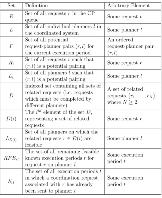
4.2.1 Notation and Definitions . . . 57
4.2.2 Example . . . 58
4.2.3 Integer Programming Formulation . . . 61
4.2.3.1 Request Values . . . 61
4.2.3.2 Non-linearity in the Objective Function . . . 62
4.2.3.4 Size of Solution Space . . . 68
4.2.3.5 Forward-Looking Component . . . 69
4.2.3.6 Heuristic Integer Programming Formulation . . . 69
5 Estimating Uncertainty 73 5.1 Notation . . . 74
5.2 Bayesian Coin Flip Model . . . 75
5.2.1 Motivation . . . 75
5.2.2 Selection of the Prior Distribution . . . 75
5.2.3 Application to Coordinated Planning . . . 77
5.3 Bayesian Logistic Regression Model . . . 79
5.3.1 Classical Logistic Regression . . . 79
5.3.2 Bayesian Logistic Regression Background . . . 80
5.3.3 Methodology . . . 81
5.3.3.1 Conditional Likelihood and Probability Model . . . 81
5.3.3.2 Prior parameter Distribution . . . 83
5.3.4 Application to Coordinated Planning . . . 90
5.3.5 Attributes for Bayesian Logistic Regression . . . 91
5.3.5.1 Probability of Request Being Sent by the Coordination Planner 91 5.3.5.2 Probability of Request Acceptance by Planner . . . 93
5.3.5.3 Probability of Request Completion by Planner . . . 97
5.4 Discussion . . . 98
5.4.1 Empirical Performance . . . 98
5.4.2 General Comparisons . . . 101
5.4.3 Implementation in the Coordinated Planning Problem . . . 103
6 Analysis and Results 105 6.1 Tractability Analysis . . . 106
6.1.1 Design . . . 106
6.1.2 Results . . . 108
6.2 Experimental Setup . . . 110
6.2.1 Coordination System Framework . . . 110
6.2.2 Comparison of Methods . . . 112 6.2.2.1 Scenario 1 . . . 112 6.2.2.2 Scenario 2 . . . 113 6.2.2.3 Scenario 3 . . . 113 6.2.2.4 Scenario 4 . . . 113 6.2.2.5 Design . . . 114 6.2.2.6 Results . . . 115 6.2.3 Sensitivity . . . 119 6.2.3.1 Design . . . 119
6.2.3.2 Results and Analysis . . . 123
6.3 Conclusions . . . 128
7 Further Research and Conclusions 129 7.1 Suggestions for Future Research . . . 129
7.1.1 Expansion of Problem Scope . . . 129
7.1.2 Mathematical Methods . . . 130
7.1.3 Suggestions for New Request Attributes . . . 132
7.1.3.1 Cloud Cover and Weather Data . . . 132
7.1.3.2 Planner-Specific Information . . . 133
7.2 Major Contributions . . . 134
7.3 Conclusions . . . 135
A UAV Specifications 137
C Parameters for Maximum Sensible Variance in a Beta Distribution 141 D Proof of LP Feasibility for Prior Calculations 143
List of Figures
3-1 Regional Targets (left) vs. Point Targets (right)—Figure courtesy of [1] . . . 36
3-2 Asynchronous Planning Cycles—Figure courtesy of [1] . . . 40
3-3 Information Flow in a Coordinated Planning System . . . 47
3-4 Phases Within a Coordinated Planning Iteration . . . 48
3-5 Single CP Iteration . . . 50
3-6 Information Flow in a System of Stovepiped Planners . . . 51
3-7 Synchronized Planning Cycles . . . 52
5-1 Performance Using Accurate Belief Statements . . . 99
5-2 Performance Using Inaccurate Belief Statements . . . 100
6-1 Tractability of Full and Heuristic Formulations . . . 109
6-2 Value of Formulations . . . 117
6-3 Value of Probability Estimation . . . 118
6-4 Myopic Benchmark Comparisons . . . 119
6-5 Effects of Various δ on [0, 1] . . . 122
6-6 Sensitivity of Formulations to ε . . . 124
List of Tables
3.1 List of Request Specifications . . . 37
3.2 Example Task Types . . . 38
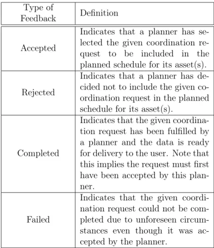
3.3 Potential Types of Status Feedback from Planners . . . 43
4.1 Set Definitions . . . 59
4.2 Important Quantities . . . 60
4.3 Requests in Example Queue . . . 60
4.4 Example Sets (Part I) . . . 60
4.5 Example Sets (Part II) . . . 61
4.6 Features Used to Determine Values of Request-Planner Pairings . . . 62
6.1 Sensitivity Parameter Values . . . 122
6.2 Mean and Standard Deviation Comparisons . . . 127
A.1 UAV Specifications . . . 137
B.1 Satellite Specifications (see [2] for details) . . . 139
E.1 Tractability Results for Full Formulation . . . 148
Chapter 1
Introduction
1.1
Background
Currently, there are many organizations in the United States that use unmanned assets, such as satellites or drones, to collect information. This may include taking pictures of the ground, gathering infrared photos, taking atmospheric pressure measurements, or any conceivable form of data collection. Often these separate organizations have overlapping collection interests or flight plans that are sending sensors into similar regions. Exploiting such common interests between the organizations could potentially free up asset sensing time to be used elsewhere. Unfortunately, different organizations often have command and control stations for their assets that are spread across the nation. Even within an organiza-tion, separate missions might control their assets from different locations. This separation can make exploitation of common collection interests a nontrivial task because it might be difficult to gather all of the representatives for a meeting or even a telephone conference. Each of these organizations also has different objectives—a problem that further isolates each organization/mission and complicates mutual correspondence. An automated, coordi-nated approach to assigning collection tasks among these segregated missions/organizations, or “stovepipes,” has the potential to significantly reduce the problem of isolation in order to
increase the realized utility of the collections made by all assets between the organizations. Organizations collect data for various purposes. The National Aeronautics and Space Administration (NASA) collects data for scientific research; The Department of Defense (DOD) collects data for intelligence, surveillance and reconnaissance. Often these organiza-tions utilize their own air and/or space assets in order to best manage the collection param-eters—time, location of targets, desired level of resolution, and type of data being obtained (infrared, visible light, atmospheric pressure, etc.) for their targets of interest. Even within organizations (e.g., branches of DOD or NASA) there may be separate, generally unshared, collection assets. The stovepiped nature of these planners prevents cross-communication among separate sensing assets, creating inefficiencies that could be avoided through coordi-nated planning. Such isolation between operations of separate planners means that requests may not be allocated to the most appropriate sensors based on their specific requirements. Additionally, some missions require multiple simultaneous sensor data collections at a single location (called dual collections) that can be very difficult to accomplish with the limited assets available in a stovepiped system. Using a coordinated approach, the likelihood of fulfilling such dual collection requests can increase because the number and type of available assets is much larger. Conceptually, the coordinated approach is instantiated in the coordi-nation planner (CP), which utilizes an algorithmic method for analyzing the parameters of various collection tasks within a set of planners (i.e., missions or organizations) in order to determine the best allocation of collection requests to planners. By performing this analysis and allocation, the CP effectively increases the ability of the assets on each of the stovepiped planners to complete all collection requests.
1.2
Contributions
We present a method for coordinating various collection tasks between the planning sys-tems in order to vastly increase the utility that can be gained from air and space assets.
This method focuses on allocation of collection requests to scheduling systems rather than complete centralized planning over the entire system so that the current planning infrastruc-ture can be maintained without changing any aspects of the schedulers. We expand on the previous work done in [1] by inclusion of a learning method to capture information about the uncertainty involved in data collection from such assets. We subsequently utilize this information in a mathematical programming method for resource allocation. With the in-formation that we gain using on-line learning, this mathematical programming formulation has the ability to model many tradeoffs pertaining to the assignment of collection tasks to planning systems.
We begin the design of the CP by addressing how to predict whether a certain coordina-tion request will be accepted or rejected, and subsequently completed or failed—a research topic that has not been previously considered. To do this, we combine prior intuition and knowledge about the individual planning systems with real-time data about which requests were accepted, rejected, completed, or failed using Bayesian analysis, which is then translated into probability estimates of being accepted and then completed. We also add a forward-looking component to estimate the probability that a request will be sent in the future to aid in the decision making process. Estimates are updated off-line between iterations in order to take all available observations into account.
We incorporate these probability estimates into an integer programming (IP) model which pairs the requests to planners. This IP is designed to model a variety of tradeoffs, such as duplicating requests to maximize completion probabilities vs. sending a wide variety of requests to maximize overall utility, or delaying requests until a later time if another request is more urgent. We apply this solution technique to a few potential scenarios, the results of which indicate that these models produce vastly improved utility in the sensing collection results obtained over the current stovepiped approach, whether “utility” is number of requests completed, average priority of the requests (in a system where certain requests are more important than others), or any other objective.
The results suggest that software implementations of the proposed CP could reap consid-erable benefits over current planning methods. This has practical significance as we intend on implementing a variation of this research in an ongoing collaboration with NASA to help utilize air and space sensing assets more effectively.
1.3
Thesis Outline
This thesis develops and analyzes a proposed method for coordinated planning through seven chapters. An overview of the thesis organization follows.
Chapter 2 develops the coordinated planning construct. This chapter begins by intro-ducing the operational concept through a review of previous work. This review is followed by a summary of other previous literature relevant to the coordinated planning problem. Various scenarios are presented in which a CP could be of use, including climate studies and intelligence/reconnaissance settings. A short discussion about uncertainty and tradeoffs inherent to the CP is presented. This is followed by a description of the versatility of the CP, including the possibility of implementing the CP within a web service, as part of sensor webs with different levels of data sharing between assets, or even within a monetized setting. The chapter concludes with a short overview of how requests can be obtained from customers, as well as how the CP can handle simultaneous or related requests.
Chapter 3 defines the context of the coordination planning problem considered in this thesis. All of the terminology relevant to the problem is defined at the beginning, including the coordination system interface and an explicit definition of what it means to send a request for data collection. The concepts of planners and assets are fully developed along with the idea of planning cycles used for modeling. The coordinated planning problem is then explicitly defined, which includes definitions of all the specifications, constraints, and other considerations for creating a CP. The chapter closes by showing the flow of information in a coordinated system as compared to other system types (such as stovepiped systems), which
includes a discussion of how to incorporate knowledge about uncertainty into the problem. Chapter 4 formalizes the problem into mathematical notation and produces an integer programming formulation to solve the problem of allocating requests to planners in a given iteration of coordinated planning. The data, metrics, and decisions are defined at the begin-ning, followed by a discussion of the modeling approach that is taken for this problem. A rigorous definition of the mathematical notation is presented, immediately followed by a de-velopment of how to value request-planner pairings as well as how to incorporate knowledge about uncertainty to create an expected value. The chapter closes by discussing practically sized problems and limitations in the modeling approach presented.
Chapter 5 shows how to estimate the probabilities introduced in Chapter 4 to incorpo-rate any information about the uncertainty inherent to the problem into the mathematical programming formulation. Two Bayesian methods are proposed—a simple “coin flip” model and a more complicated Bayesian logistic regression model. A novel linear programming based method is presented for constructing a prior parameter distribution in the Bayesian logistic regression model, which is designed to be able to incorporate prior beliefs (as well as confidence in those beliefs) into the construction of the prior. This linear programming based method is designed to work for any Bayesian logistic regression model and therefore has ap-plicability beyond the scope of this thesis. The chapter concludes with a brief discussion of the benefits and drawbacks to each Bayesian model.
Chapter 6 conducts an empirical analysis of the methods presented in this thesis. The first experiment performed is a direct analysis of the tractability of the formulation. This is important since integer programs are known to become inefficient for large problem sizes. The next experiment involves investigation of how well the methods of this thesis compare to a stovepiped system in a few different scenarios, including a discussion of the value gained by using information to estimate probabilities. The final experiment involves testing the sensi-tivity of the mathematical programming formulation to errors that might arise in probability estimation.
Chapter 7 provides a short description of differences between the research presented in this paper and that presented in previous research, as well as recommendations for further research relevant to the coordinated planning problem. This includes assumptions that could be relaxed, interesting modeling approaches that could be pursued, or other research that might be interesting.
Chapter 2
Coordinated Planning Background
Coordinated planning can be implemented within any situation that requires the use of ad-vanced sensor systems that exist in satellites, unmanned aerial vehicles (UAVs), underwater vehicles, or ground vehicles. Studies requiring these assets have become increasingly more prevalent in the past few years. One of the major recent uses of sensor systems involves em-ploying satellites or UAVs to study Earth’s climate. The Earth Observing System, designed by NASA, is one such example of a set of sensors being used for climatology [3]. Within this system, NASA has launched many satellites. The Suomi National Polar-orbiting Partner-ship (NPP) satellite is one of these, launched in October 2011. This satellite orbits Earth about 14 times per day, observing nearly the entire surface in this time period. The sensors on board NPP perform many different climate-related operations, such as creating global models of temperature and moisture profiles for use by meteorologists, monitoring the ozone levels near the poles, measuring atmospheric and oceanic properties, and examining both emitted and reflected radiation from Earth’s surface [3]. The Aqua satellite, also in the NASA Earth Observing System, collects information about “Earth’s water cycle, including evaporation from the oceans, water vapor in the atmosphere, clouds, precipitation, soil mois-ture, sea ice, land ice, and snow cover on the land and ice. Additional variables also being measured by Aqua include radiative energy fluxes, aerosols, vegetation cover on the land,
phytoplankton and dissolved organic matter in the oceans, and air, land, and water temper-atures” [4]. These are just two examples of the many satellites currently in orbit collecting climate-related information, all of which have some sort of overlapping interests and may even contain some of the same sensor models. As such, implementing a coordinated plan-ning scheme within satellite planners of the Earth Observing System, or any climate related satellites, could prevent redundant gathering of the same data, while spreading collection demands more evenly across the satellites for better sensor utilization.
Recent interest in examining natural disasters has also increased, furthering the need to efficiently coordinate between sensor planners. The Hurricane and Severe Storm Sentinel (HS3) , a NASA investigation designed to enhance “understanding of the processes that underlie hurricane intensity change in the Atlantic Ocean basin,” is one such example of a mission trying to learn more about natural disasters [5]. The United States Forest Service (USFS) has also recently been employing UAVs and satellites to help image active wildfires, reducing the risks of “smoke, excessive thermal wind drafts, and unfamiliar terrain” on the pilots that usually do the imaging in airplanes or helicopters [6]. The USFS also uses UAVs to collect data for invasive species professionals [7]. With all of these potential applications, coordinated planning could provide a massive benefit through the sharing of information between these organizations.
Science and forestry are not the only areas that could benefit from coordinated planning. The intelligence and reconnaissance communities utilize a tremendous amount of autonomous vehicles and sensing assets to complete missions. However, the United States intelligence and reconnaissance communities are divided into many separate organizations, including the National Security Agency, Central Intelligence Agency, National Reconnaissance Office, and individual intelligence agencies of the armed services. This division suggests that there is a large amount of overlapping desires for data collection which could be pooled in a manner that allows each individual organization to gain more utility from data collections. Indeed, the concept of coordination is already recognized as being important; according to the Joint
Doctrine for Targeting, which defines how targets for remote sensing should be created and collected, a “primary consideration” for developing targeting plans “is the joint force’s ability to coordinate, deconflict, prioritize, synchronize, integrate, and assess joint targeting operations” [8]. Clearly a coordinated planning framework is in line with this objective, and certainly could improve the overall utility of sensing data collected for the intelligence and reconnaissance communities.
2.1
Previous Literature
The initial groundwork for developing a CP was performed by Thomas Herold in [1]. Herold goes into depth describing the operational concept of the CP in a real-world context, which he uses to motivate a description of the coordinated planning problem. Herold provides a linear programming formulation to allocate requests across to the mission planners for the available sensors in a manner by optimizing a construct that he calls the value function. Herold’s value function uses a weighted combination of quantities relating to request priority, observation quality on a given sensor, distance for a UAV to fly from its home base, satellite viewing angle, length of the time window for request completion, and whether or not the request should be collected simultaneously with other requests. Herold then provides a study on how changing the weights for these attributes affects the performance of the CP using a controlled test scenario. Using these results, Herold proposes a method for choosing the weights by solving small optimization problems using data obtained by simulating the system. The results from Herold show that using a coordinated approach can provide a significant benefit in a sensor system.
Related analysis pertaining to centralized planning of multiple viewing assets (satellites, UAV, etc.) has been widely studied. In [9], Sakamoto considers the problem of efficiently planning missions for a collection of UAVs in a centralized manner. He proposes a robust mixed-integer programming formulation in order to create UAV mission plans that have a
high likelihood of being feasible in a stochastic environment. In [10], Blair Negron solves a very similar problem, planning missions for multiple UAVs given a set of tasks in three dimensions. Negron solves a very general problem, including time windows, observation duration, and location information for each task, as well as maximum altitude, minimum altitude, endurance, and travel time between locations as inputs for the UAV (this notion of a data collection task presented by Negron is the basis for the concept of a request presented in Chapter 3). By including such a large amount of generality in her model, the resulting mathematical programming formulation that Negron develops becomes inefficient for large applications. To fix this issue, Negron develops a meta-heuristic that creates mission plans very efficiently without sacrificing much value from optimality, thereby allowing quick solutions even for very large problems.
In [11], the authors approach control of unmanned assets for a wide array of tasks (search, target classification, attack, damage assessment, etc.). The solution approach utilizes a hierarchical division of the problem into multiple layers of control. The authors construct and simulate an auction-based formulation to determine how to best assign tasks to various groups of vehicles. A main insight is that allowing multiple assets to cooperate on a single task provides better global results. However, the hierarchical method employed for the control of UAV task assignment and completion in [11] still addresses a version of collection planning in which all of the agents work together toward the same overall objective—not for the objectives of stovepiped planners. Thus, this article still solves a more centralized problem than the the one considered in this thesis.
The authors of [12] solve a problem of completing a large set of tasks with a small number of UAVs by utilizing a mathematical program for centralized assignment of tasks to assets, and then creating a separate scheduling algorithm to decide the paths taken by the individual assets. The main two differences between this type of problem and the coordinated planning problem are (1) the coordinated planning problem assigns tasks to planners, not to individual assets, and (2) the coordinated planning problem allows planners to have their
own scheduling/control algorithms for their assets. While these articles provide insights about other potential solution approaches for the coordinated planning problem, they all focus on highly centralized planning that does not take into account the issue of planning for asynchronous, distributed systems (i.e., stovepipes).
Work has also been performed relating to efficient tasking of satellites. The authors of [13] develop a tool for the centralized planning of a vast collection of points of interest for which a large number of satellites are available. The authors split the decisions hierarchically— first assigning tasks to satellites, then separately planning the task start and end times for each satellite to maximize the total value of the targets obtained. Both sets of decisions are performed using integer programming approaches that optimize periodically over time. The resulting real-time models are capable of handling around 100 satellites and many different points of interest. The first stage of decisions presented in [13] that assigns tasks to satellites is very similar to the decisions faced in Chapter 4. The system analyzed in [13] has full, centralized control of the satellites, knowing that no other outside tasks will be assigned to those assets. In contrast, the problem developed in Chapters 3 and 4 do not actually task assets, but send requests for data collection to the mission planners for those assets, which has much more uncertainty do to the possibility of rejection and lack of knowledge about the currently planned schedules for each asset.
The authors of [14] address the uncertainty inherent in the planning of photographs taken by a single satellite, using a mathematical programming formulation that is motivated by a Markov Decision Process. Their model considers the probability that a photograph would actually be completed if it is incorporated into the schedule for the current day, as well as the probability that the photograph will be selected and subsequently completed for a future day under a given policy, to design a schedule that maximizes the total expected value of realized photographs subject to any feasibility constraints. The latter probability is calculated by looking at the number of remaining feasible opportunities each satellite would have to potentially schedule the photograph. The authors suggest that these probabilities
can be determined either by simulation or can be adaptively learned in an on-line manner through a machine learning based approach (although the actual method for learning these probabilities was left for future research). They recommend the learning approach as it allows the formulation to adapt to changes in the system over time. This approach is used as motivation for the inclusion of forward-looking probabilities in Chapter 4 involving the chance that a request will be sent by the CP and ultimately completed by some individual planner at a future time.
A more general problem of dynamically assigning an abstract resource to an abstract task over time is considered in [15]. The problem, coined by the authors as “The Dynamic Assignment Problem,” is solved using a combination of network optimization and approx-imate dynamic programming (ADP) Techniques. The basic framework assumes that each resource can serve only one task at any given moment, but allows the tasks to appear dy-namically over time. An exact dynamic programming formulation is developed that models this problem. However, the state and decision spaces are far too large to admit a solution of the exact problem, which motivates the use of ADP. The paper develops a method utilizing ADP that iteratively solves many network assignment problems to obtain a good, although suboptimal, solution. The results show that the algorithm can significantly outperform my-opic optimization methods, or those that do not include forward looking knowledge about the future when making decisions. One of the major difficulties in using the methods pre-sented by [15] is that the solution method is heavily dependent on the efficiency obtained by solving a network optimization problem to allocate resources to tasks. Unfortunately, if other outside constraints are included, if the resources can accept more than one task in any given assignment iteration, or if there are nonlinear elements in the objective, the mathematical programming formulation might lose the efficiency inherent in the structure of a network optimization problem. As a result, the aggregation-based ADP methods that the authors use become too inefficient to implement in practice. Since all of these issues exist in the coordinated planning problem, this thesis does not implement the methods of [15].
2.2
Uncertainty and Tradeoffs in Coordinated Planning
The CP developed by Herold addresses a deterministic problem. One of the main differences in the current work is to relax deterministic assumptions so that the CP can take uncertainty into account. Characterizing this uncertainty can be difficult, as the factors that contribute significantly to uncertainty may not be obvious. Successful completion of any given request can be dependent upon natural factors such as cloud cover, appropriate weather, physical condition of the sensing assets, and even systemic factors, such as the number of requests currently being serviced by a specific planner. This paper will discuss one method for the in-corporation of knowledge about uncertainty, under the assumption that certain probabilities can be accurately estimated.
A very important piece of incorporating uncertainty into the coordinated planning ap-proach involves the ability to accurately value various tradeoffs that must be considered when performing collection management. This is no trivial task as the number of potential tradeoffs that could be modeled is quite large. Examples of considerations for a CP include: 1. Sending a low priority request now that has few or no future opportunities for collec-tion vs. sending a high priority request now that has many future opportunities for collection
2. Sending a request now to a planner with low probability of completion vs. waiting for a time when the probability of completion is higher (such as a request that may be in view of a satellite very briefly over the next hour but might be in view for a very long time three hours from now)
3. Sending a request to the planner with the most desirable sensing asset even if it has a low probability of completion vs. sending a request to the planner for a less desirable asset that may have a much higher probability of completion
to complete the request vs. not sending the low priority request
5. Sending a high value request multiple times to maximize the chance that it will be completed vs. sending the high value request once to be able to send other less valuable requests
6. Evaluating how to send requests in a system of highly saturated, highly constrained assets
7. Evaluating how to send requests if there are budget constraints
The coordinated planning methods discussed in this thesis aim to create a method of allo-cation that addresses many of these concerns.
2.3
Versatility
With an appropriate design, a coordinated planning approach can be made to apply to a large variety of potential situations. The construct developed in this thesis is designed to be flexible, thereby allowing it to be implemented in many different scenarios.
2.3.1
Web Service Implementation
A web service, or “a software system designed to support interoperable machine-to-machine interaction over a network” [16], is a natural setting for implementing a coordinated planning approach. Users who wish to collect climate, intelligence, reconnaissance, or other data from sensing assets could easily upload requests for data to the web service using either an on-line form or a predefined XML schema. The CP would then consider all of the inputs, determine sensing assets that could feasibly complete these requests, and decide an appropriate allo-cation of requests to the mission planners for these assets so as to maximize overall value subject to various limitations, including budgetary constraints and capacity limits for the rate of requests being sent to the mission planners [17, 13]. The web service would then
be designed to interface with on-line request input services for the planners of various sens-ing assets, or directly with the internal networks of organizations ownsens-ing the systems if an agreement could be made with those organizations. This setup immediately overcomes the problem of stovepipes mentioned in Chapter 1 by using the internet to overcome geographi-cal separation, interfacing directly with the various planners, and intelligently deciding the best allocations of requests to the planners for sensing assets.
2.3.2
Sensor Web Architecture
The implementation of the CP as part of a web service could help to fulfill the concept of a sensor web, which “consists of intra-communicating, spatially-distributed sensor pods that are deployed to monitor and explore environments” so that “information gathered by one pod is shared and used by other pods” [18]. The sensor web architecture is a conceptual design in which various sensing assets have complete knowledge of the locations and data from all other sensors, so that planning for the collection of data can be coordinated across all the platforms.
In many practical cases it may be desirable (or required) to only have a partial sensor web architecture, in which some data is shared across the various sensing assets but not all of the data. A web-service based CP would be very useful in these situations as well because, by design, the CP leaves control of the assets to the missions and optimizes based on the request that it receives. This type of design could be useful in a situation where different organizations, such as the U.S. military, NASA, the National Oceanic and Atmospheric Administration (NOAA), and the United States Geological Survey (USGS), take advantage of the collective capabilities of all their assets while still maintaining full operational control over their respective sensors. This is an operation that makes sense in much of the current sensing systems, although research has not addressed a good way to plan within this infrastructure. As such, the work that we do in this paper will offer important insight into how to plan for partial sensor webs.
It is even possible to utilize the CP in an environment without any sensor web, but rather as an aid in planning for a single mission. For example, the mission planners for HS3 at NASA do a large amount of research observing the behavior of hurricanes using UAVs [5]. A version of the CP could be used prior to designing the mission plans for any given day to determine if satellites such as Earth-Observing 1 could potentially collect any specific pieces of data, using likelihoods and priorities of various proposed pieces of data to figure out the best way to assign requests, while considering budgetary or capacity constraints [19, 5]. In this case, the importance of controlling for uncertainty would be very high since a single user or group of users would be accepting all of the risk inherent in trusting completion of data requests to external assets.
2.3.3
Monetized Setting
A web-service or web-interface based implementation of the CP could also be used in a for-profit setting. In this situation, the coordination planning algorithm would be run by a single owner with some level of access to the resources of various assets. Requests for data would be input to the CP web interface along with the amount of money that the user would be willing to pay to have the request completed. The CP, knowing its own budget and any capacity constraints of the planners, as well as any costs associated with completing a request, would take these requests and assign them to planners in order to maximize the total expected profit over some planning horizon.
2.3.4
Obtaining Requests from Users
We have been assuming in our discussion that users know exactly what type of data they want to have collected. However, often users do not know the exact location, sensor type, or time that they want to collect data. In this case, a CP with probability estimates for the completion of requests could be of use as it would be able to present different options to the user along with probabilities of completion for each option. These options would be
generated by knowledge of where the sensors in the coordination system would be located over time. The user would then select one or more of the options to input as requests. However, design of this suggestion system is beyond the scope of this thesis.
2.3.5
Related Requests
Sometimes users may have requests which must be completed by different planners. For example, a user may desire simultaneous collections of information pertaining to a single target, such as a satellite image of a hurricane at the same time that an aerial vehicle obtains pressure or temperature readings. More generally, a user may have a set of requests for similar sets of data, referred to as related requests, which must be completed by different assets. These types of situations can be handled much more easily through the use of a CP than by using stovepiped planners as there are many more options available for servicing requests.
Chapter 3
Modeling Assumptions and Problem
Definition
As shown in the previous chapter, there are many potential uses and implementations for a coordinated planning system. Thus, it is important to clearly define the modeling assump-tions that will be used in order to identify the capabilities and limitaassump-tions of a CP.
3.1
Terminology
We begin by defining the main terminology used throughout this paper. Some of these terms have already been introduced (e.g., request and planner ) and will now be formally defined; others will be completely new. These terms have been constructed in a manner that should agree with common conventions that exist in sensor planning literature, although some terms are unique to the idea of coordinated planning. We also note that while many of the terms in this paper are consistent with those of the previous work done in [1], some have been slightly altered. Thus, it is important to follow the definitions listed here while reading this paper. Each important term will be introduced in boldface italics, with all subsequent references in plain text.
3.1.1
Coordination System Interface and Requests
At the highest level is the coordination system interface. This is the actual computer program, person, or other device which collects requests from people or machines who wish to use the CP Technology, known as users. These requests are the unique collection specifications for obtaining a piece of data as defined by a user. These specifications could potentially be defined in different ways. For example, requests must be associated with some location, known as a target , since we are attempting to collect data either on Earth’s surface or in its atmosphere. However, the manner in which a request is defined could vary. A user may wish to view an entire region of Earth and therefore define a regional target , or the user may desire an image or piece of data at a single point target defined by latitude, longitude, and altitude (see Figure 3-1 for comparison).
Figure 3-1: Regional Targets (left) vs. Point Targets (right)—Figure courtesy of [1]
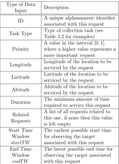
A summary of all specifications required for each point target request is given in Table 3.1. We assume that any regional target can be discretized into point targets. This discretization may be done by users or it may be done by the coordination system interface. We note that this is a realistic assumption because many planners require that requests external to their own desires should be given with point targets in order to reduce the burden of scheduling. A request will also define the specific task that must be completed, which is the actual piece of data to be collected. This could be a picture, infrared image, altitude measurement, barometric pressure reading, temperature reading, etc. A list of some example task types is given in Table 3.2.
Type of Data
Input Description
ID A unique alphanumeric identifier associated with this request Task Type Type of collection task (see
Table 3.2 for examples) Priority
A value in the interval [0, 1], where a higher value represents a more important request
Longitude Longitude of the location to be serviced by the request
Latitude Latitude of the location to be serviced by the request
Altitude Altitude of the location to be serviced by the request
Duration The minimum amount of time required to service this request Related
Requests
A list of all requests related to this one, if none then this value is left empty
Start Time Window startT W
The earliest possible start time for observing the target
associated with this request End Time
Window endT W
The latest possible end time for observing the target associated with this request
Task Type Description
Ground Image Image of a specific location on the ground
Cloud Image
Image of the cloud structure in a specific location, usually to analyze a specific weather event, such as a hurricane
Infrared Ground Image
Ground Image using an infrared sensor
Infrared Cloud Image
Cloud image using infrared sensor
Topological Survey
Topological or altitude reading at a specific location
Pressure Reading
Measurement of the atmospheric pressure at a certain location Table 3.2: Example Task Types
Sometimes users may have requests which must be completed by different planners. For example, a user may desire simultaneous collections of information pertaining to a single target, such as a satellite image of a hurricane at the same time that an aerial vehicle obtains pressure or temperature readings. In this example, the simultaneous collection would need to be completed by different assets, although this may not always be the case. More generally, any set of requests which must be completed by different sensors we refer to as related requests. We assume for simplicity that all requests within a set of related requests have the same set of feasible planners, modeling the realistic desire to have multiple simultaneous collections from some set of planners.
3.1.2
Planners and Assets
A planner is the entity that schedules requests for completion on various assets, which could be UAVs, airplanes, satellites, ground vehicles, or underwater vehicles, although the software and simulations developed in this paper will limit assets to being UAVs or satellites. Formally, the planner is a function that takes requests as inputs, and produces an ordered set of times in which an asset or set of assets will complete some or all of the requests that
are feasible (i.e., a mission plan) as outputs. For example, a planner could be a computer program that produces a UAV flight path to image a specific set of locations, or a human writing a flight path on paper.
3.1.2.1 Planning Cycles
Each planner has its own planning cycle which consists of planning , upload , and exe-cution phases, where the length of the exeexe-cution phase is equal to the combined lengths of the planning and upload phases. Requests can only be completed during an execution phase. We assume that for a given execution phase, each planner will only consider feasible requests submitted during the planning phase immediately prior to that execution phase. For example, examining Figure 3-2, we see that in order for a request to be completed by the UAV planner during execution phase 2, it must be submitted during planning phase 2 for that planner. We do not assume that planners have synchronized cycles, meaning that they can all have customized phase start and end times as shown in Figure 3-2 for an exam-ple with one UAV planner and three satellite planners. We note that while the entire time line is covered by planning, upload, and execution phases in this figure, this coverage may not always exist due to breaks in planning for maintenance purposes. However, handling extraordinary breaks in the cycle is beyond the scope of this thesis.
3.1.2.2 Assets and Sensors
Each planner schedules incoming requests using sensors on one or more assets. The sen-sor(s) carried on each asset will perform the actual tasks associated with the requests, such as capturing an image or recording a temperature. Assets are further differentiated as being taskable or non-taskable. A taskable asset is one that is willing to accept requests as input for developing a mission plan, while a non-taskable asset generates its mission plan without regard to external requests [1]. A UAV is non-taskable if its planner chooses a flight path based on its own internal collection needs before taking requests; a satellite is non-taskable
Figure 3-2: Asynchronous Planning Cycles—Figure courtesy of [1]
if the pointing angles of its sensors are known before taking requests. Generally, if a satellite is non-taskable, it is because the satellite is always “on,” i.e., it always points at the same angle toward Earth and continuously collects data. In contrast, taskable assets are those in which the associated planner will simultaneously analyze its own data collection needs as well as other external requests when deciding a flight path (UAV) or set of pointing angles (satellite).
3.1.2.3 Asset Specifications
Each asset has a set of specifications for a given execution phase. Those specifications relevant to a UAV are listed in Appendix A, while those relevant to a satellite are given in Appendix B. These specifications define the physical limits of the asset, as well as the general region to be viewed for that execution phase. We assume that all of the specifications for each asset on any given planner are known.
3.1.3
The Coordinated Planning Problem
The coordinated planning problem which we analyze in this paper involves coordinating collection requests between stovepiped missions to increase the overall utility of the system, without forcing the missions to significantly alter their planning systems. The coordina-tion planner (CP ) first takes user-defined requests and prior informacoordina-tion about colleccoordina-tion interests from the participating planners as inputs in order to determine efficient pairings of requests with planners. The CP then must send its own coordination requests to the planners that it considers in its system, separately asking each one to complete some subset of the user-defined requests as determined by the pairings. It is imperative that these re-quests be sent during the appropriate planning phases for each planner, so we assume that the CP is aware of the planning cycles for each planner.
The CP builds up a queue of requests over time which is the set of all user-defined requests which have not yet been completed. The CP reviews this queue periodically to create pairings and coordination requests, which we refer to as the CP iteration . The period of this review is referred to as the CP iteration length . In order to ensure that the CP always has at least one opportunity to send requests during each planning period of a given planner, the CP iteration length is assumed to be shorter than the lengths of the planning periods for all of the individual planners. This assumption could be relaxed in reality if needed, but the cost would be that the CP may not have the opportunity to send requests for some execution periods on individual planners.
3.1.3.1 Opportunity Finder
The first step in reviewing the CP queue involves employing an opportunity finder , which is a filter to determine feasible pairings of requests to planners. For example, the opportunity finder would filter out the possibility of pairing a request in Nevada with a planner for a non-taskable UAV that only flies over the Atlantic Ocean, or a satellite that does not pass over Nevada. We assume that this opportunity finder finds all pairings that have a positive
probability of being completed, and removes all other pairings. The opportunity finder utilizes the specifications of the assets to make these determinations. For the analysis that is presented in this thesis, the opportunity finder takes into account the time window of a request, whether the endurance of a UAV is long enough to travel the great-circle distance to the request location and back again [20, 21], and whether the predicted orbit of a satellite using secular J2 perturbation theory has a line-of-sight to the request location [2].
3.1.3.2 Coordination Requests
The next step involves choosing the best pairings and then sending the coordination requests to the planners. Each of these coordination requests can then be accepted , rejected , completed , or failed by the individual planners—we call this the status of the coordination requests (see Table 3.3 for explanation of these terms). We require all planners to inform the CP when coordination requests are completed or failed; however, we allow planners the option of informing the CP when requests are accepted or rejected. In order to differentiate these two options, we refer to planners as being informative if they inform the CP about accepted and rejected requests; otherwise the planners are non-informative. We assume that all planners land in exactly one of these two categories, i.e., we do not have any “partially informative” planners which give feedback for some requests but not for others. We also assume that a user request is completed if and only if at least one coordination request associated with that user request is completed; otherwise the user request is failed.
3.1.3.3 Individual Planner Specifications
We assume that each planner also has a set of specifications which defines the level of interaction that it has with the CP. The first of these, i.e. whether a planner is informative or non-informative, has already been explained. The remainder of the specifications are described here.
Type of
Feedback Definition
Accepted
Indicates that a planner has se-lected the given coordination re-quest to be included in the planned schedule for its asset(s).
Rejected
Indicates that a planner has de-cided not to include the given co-ordination request in the planned schedule for its asset(s).
Completed
Indicates that the given coordina-tion request has been fulfilled by a planner and the data is ready for delivery to the user. Note that this implies the request must first have been accepted by this plan-ner.
Failed
Indicates that the given coordi-nation request could not be com-pleted due to unforeseen circum-stances even though it was ac-cepted by the planner.
2. Management Authority: Each planner will have either an internal or external management authority. Conceptually, an internally managed planner is one for which the CP has full knowledge of an asset’s planning process, location, and schedule, while an externally managed asset is one for which this information is not known. We do not explicitly differentiate between these two types of planners in our analysis as long as all UAV planners provide the information given in Appendix A and all satellite planners provide the information given in Appendix B. We leave the determination of planner-specific important information to future research, which could be used to influence information that could be obtained from internally managed planners. 3. Assets: Each planner has assets associated with it which are known to the CP in
advance, along with the specifications of those assets.
4. Capacity: We assume that each planner has a maximum number of coordination requests that it can receive per unit of time for a given execution period, which is known as the planner’s capacity. For example, if the capacity of a planner is 10 coordination requests per hour, then an execution period of length two hours would allow a maximum of 20 coordination requests to be considered. Some of the time this capacity is explicitly defined by the operators of the planners, as is the case for sensor planning services following the specification in [17]. Other times, this constraint exists as a contractual guarantee by the CP to prevent over saturation of planners with coordination requests. In a situation where neither of these hold true, it may still be intelligent to impose the capacity constraints anyway based on the number of requests completed by various planners, although research into how to best choose such values is beyond the scope of this thesis. By imposing these capacity constraints, we can reasonably assume that, given the general location in which an asset will be collecting sensing data, the probability that a planner will complete a given request is negligibly influenced by the other coordination requests being sent to that planner. This allows
for the reasonable independence assumption that if requests r1, . . . , rk are all sent to
planner l, then the set of probabilistic events of the form “request ri is completed by
planner l” for all i ∈ {1, . . . , k} form an independent set of events, as do the events “request ri is accepted by planner l” for all i ∈ {1, . . . , k}.
5. Reservation Fee: A given planner l might impose a “reservation fee” in dollars of cl > 0 per coordination request that it considers. This is more common in planners for
commercial assets which must either recoup expenses or make a profit. These funds are assumed to be collected upon submission of the request, although they might be refundable at a later time if the planner does not complete the request. We assume that there is a set amount of funds available to the CP at each iteration for the intent of satisfying necessary reservation fees.
3.1.3.4 Weather and Nature
A final piece of information that must be dealt with in the coordinated planning problem is the issue of weather. There are many potential disturbances that could affect the performance of various assets, including cloud cover, wind speed, precipitation, and other natural factors. For the scope of this thesis, we assume that the manager of the CP has the option to input which natural factors he/she feels have the biggest impact on the probability that a request will be completed. We choose to leave the option open for including these features because different situations in which the CP is employed may require different factors to be considered. We leave the analysis of determining the best features for certain situations for future research. However, we note that it is possible to implement the methods described in this paper without rigorous feature selection research.
3.1.3.5 Other Modeling Assumptions
1. Budget: The manager of the CP will likely not have unlimited funds to offset the reservation fees of coordination requests, even if the money is refundable. We model
this idea by assuming that the coordinator has a maximum amount of money per unit of time that is available for reservation fees—or a budget. For example, if the CP iteration length is 2 hours and the budget gives $500 per hour for reservation fees, then we assume that at each iteration the total amount of reservation fees cannot exceed $1,000.
2. Request Sending Limits: We allow the CP to send multiple coordination requests to distinct individual planners in an effort to complete a single user request. However, we do not want to send too many coordination requests for any single user request, regardless of the value assigned to that request or its probability of completion, because one of the purposes of the CP is to use resources efficiently. We model this desire by implementing a strict limit on the number of coordination requests that can be generated for each user request per unit of time.
3.2
Flow of Information
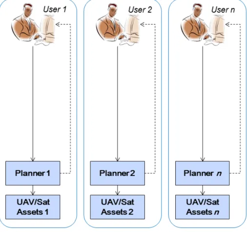
General purpose collection management requires a large flow of information between users and planners. This flow of information can be streamlined by the use of coordinated plan-ning as we will now show. For comparative purposes, we also explain the information flow used currently (“stovepiped systems”), as well as the ideal, yet usually impractical, situation (“synchronized planning systems”).
3.2.1
Coordinated System
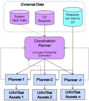
The coordinated system which we utilize maintains all of the same communication channels as the stovepiped system, but adds in two extra additional options for users. The first additional option allows the user to input requests to the coordination system interface rather than directly to the planners. The second option allows users to still input requests directly to the planners, after first querying the coordination system interface via a web service to
obtain information pertaining to the likelihood that their request(s) would be completed by various planners, including which planners would actually have the opportunity to complete that request. All of this information flow is depicted in Figure 3-3.
Figure 3-3: Information Flow in a Coordinated Planning System
We see that the CP does not actually perform any of the scheduling for the individual planners. It is important to note that when employing a coordinated system, we do not alter any of the current infrastructure—rather we add to what already exists. Thus, we allow for planners to exhibit asynchronous planning cycles as mentioned previously, which means that deadlines for submission of requests could be different for each planner.
3.2.2
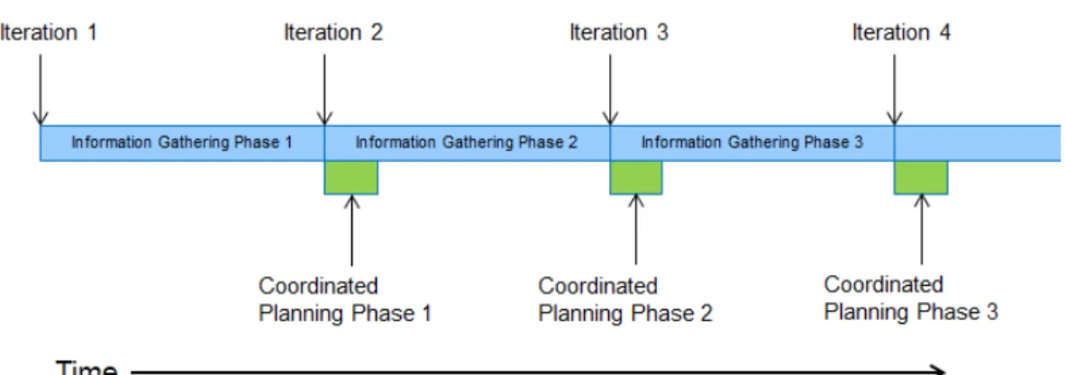
Coordinated Planning Iteration
The coordinated planning iteration consists of two phases: the information gathering phase and the coordinated planning phase. The information gathering phase begins at periodically spaced epochs in time, where the period between epochs is the aforementioned CP iteration
length. This phase continues until the next epoch, at which point a new coordinated planning phase and information gathering phase are initiated. This coordinated planning phase ends when all coordination requests for the current iteration have been sent to planners, and is in general much shorter than the information gathering phase. This process is illustrated in Figure 3-4. Note that information gathering and coordinated planning phases overlap such that the ith coordinated planning phase starts simultaneously with information gathering phase i + 1, although the coordinated planning phase is much shorter and therefore ends earlier.
Figure 3-4: Phases Within a Coordinated Planning Iteration
3.2.2.1 Information Gathering Phase
During the information gathering phase, users input their requests to the CP via the co-ordination system interface, which adds the requests to the queue. Also during this phase the CP receives feedback from the individual planners pertaining to the status of previ-ously assigned coordination requests. Any requests that are completed during this phase are removed from the queue, and the completed collection data is made available to the appro-priate users. All other notifications, i.e., accepted, rejected, and failed, are parsed into data which is stored for later use. We assume that all informative planners return information
about accepted/rejected coordination requests at some time after the coordination request has been sent but before the execution period begins for the appropriate request-planner pairing. We do not make any explicit assumptions within our mathematical model as to when planners inform the CP about completed/failed requests other than it has to be after the execution period has ended for the appropriate pairing. However, for analysis purposes, we will only consider scenarios in which the CP is informed of completions and failures im-mediately following the end of the appropriate execution periods. This models the idea that planners should desire to make this information available as quickly as possible.
3.2.2.2 Coordinated Planning Phase
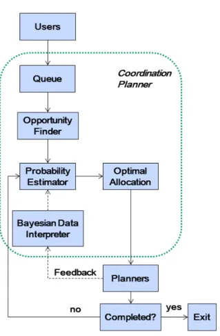
During the coordinated planning phase, all of the data collected from the information gath-ering phase is reviewed in order to convert user requests into coordination requests which can be assigned to the planners. This process begins by passing all requests in the queue through the opportunity finder to determine feasible pairings of requests to planners. Then, a probability estimator reviews all of the stored data pertaining to the results of prior coor-dination requests (i.e., the defining attributes of the coorcoor-dination requests, as well as whether they were accepted/rejected, completed/failed and by which planner) to create probability estimates for acceptance and completion of all feasible pairings of requests to planners. This information is sent to an optimization algorithm which determines efficient pairings relative to some predefined utility (e.g., number of requests completed), and then these pairings are sent to the appropriate planners as coordination requests. The coordinated planning iteration is depicted pictorially in Figure 3-5. In this flowchart, the steps associated with the coordination planning phase are located inside of the dotted line, and the information gathering steps are outside this line (more details on the mathematics behind these steps are given in the following chapters).
3.2.3
Other System Designs
3.2.3.1 Stovepiped Systems
Presently, planners tend to act in the stovepiped manner described in Section 1.1 where the operators of various assets do not communicate with operators of other assets. In this system, users input requests directly to the planners following the solid arrows in Figure 3-6, and planners return completed data requests to the users following the dotted arrows in the figure.
Figure 3-6: Information Flow in a System of Stovepiped Planners
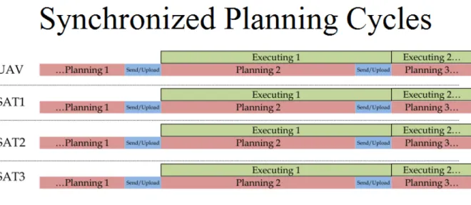
3.2.3.2 Synchronized Planning Systems
The synchronized planning system architecture is a theoretical concept that has been researched extensively [1, 13]. In this construct, some subset(s) of the planners are forced to
have the exact same planning cycle as shown in Figure 3-7 (hence the name “synchronized planning systems”), rather than exhibiting the asynchronous planning cycles shown in Figure 3-2 which are allowed in a coordinated planning system.
Figure 3-7: Synchronized Planning Cycles
3.2.3.3 Brief Comparison with Coordinated System
As has already been mentioned, stovepiped systems present a vast array of problems and inefficiencies in collection management. The lack of communication in these systems forces users to bear the burden of finding the best possible sensor(s) to use for their specific requests, which can lead to users trying to locally optimize their schedules without regard for other users that may want to employ some of the same assets. Users may also be unaware of the benefits of certain assets, or simply not have the personnel contacts to use other assets that would be well-suited for their tasks. Some other major disadvantages of stovepipes include their inability to efficiently find piggybacking opportunities (i.e. chances to add their requests onto the previously scheduled plans of a different asset which may be operating in a desirable location), or from pooling requests between various users to find a more efficient allocation of requests to sensors.
![Figure 3-1: Regional Targets (left) vs. Point Targets (right)—Figure courtesy of [1]](https://thumb-eu.123doks.com/thumbv2/123doknet/14491722.525971/36.918.256.666.527.694/figure-regional-targets-point-targets-right-figure-courtesy.webp)
![Figure 3-2: Asynchronous Planning Cycles—Figure courtesy of [1]](https://thumb-eu.123doks.com/thumbv2/123doknet/14491722.525971/40.918.142.798.212.419/figure-asynchronous-planning-cycles-figure-courtesy-of.webp)