HAL Id: hal-00297466
https://hal.archives-ouvertes.fr/hal-00297466
Submitted on 5 Jun 2008
HAL is a multi-disciplinary open access
archive for the deposit and dissemination of
sci-entific research documents, whether they are
pub-lished or not. The documents may come from
teaching and research institutions in France or
abroad, or from public or private research centers.
L’archive ouverte pluridisciplinaire HAL, est
destinée au dépôt et à la diffusion de documents
scientifiques de niveau recherche, publiés ou non,
émanant des établissements d’enseignement et de
recherche français ou étrangers, des laboratoires
publics ou privés.
An observational and numerical case study of a flash sea
storm over the Gulf of Genoa
A. Orlandi, F. Pasi, L. F. Onorato, S. Gallino
To cite this version:
A. Orlandi, F. Pasi, L. F. Onorato, S. Gallino. An observational and numerical case study of a flash
sea storm over the Gulf of Genoa. Advances in Science and Research, Copernicus Publications, 2008,
2, pp.107-112. �hal-00297466�
Adv. Sci. Res., 2, 107–112, 2008 www.adv-sci-res.net/2/107/2008/
©Author(s) 2008. This work is distributed under the Creative Commons Attribution 3.0 License.
Advances in
Science and
Research
EMS
Annual
Meeting
and
8th
Eur
opean
Confer
ence
on
Applications
of
Meteor
olo
gy
2007
An observational and numerical case study of a flash sea
storm over the Gulf of Genoa
A. Orlandi1, F. Pasi1, L. F. Onorato2, and S. Gallino2
1Laboratory of Meteorology and Modelling (LaMMA) CNR-IBIMET, Firenze, Italy 2Centro Funzionale Meteo-Idrologico di Protezione Civile (ARPAL CFMI-PC), Genova, Italy
Received: 31 December 2007 – Revised: 21 April 2008 – Accepted: 24 April 2008 – Published: 5 June 2008 Abstract. During the night between the 8 and 9 December 2006 the seawall of the Savona harbour (Liguria Region in north west of Italy) was overtopped by waves. In this work the “Savona flash sea storm” has been studied by analyzing the data recorded by meteo-marine observing stations and the data produced by high resolution meteo-marine numerical models. The data show that, due to the presence of a fast moving low pressure system, the event was characterized by a rapid transition and interaction between two different regimes of winds and related sea states.
The results of the study suggest that the most damaging dynamics of the event could be correlated to a bi-modal structure of the wave spectrum. Based on this the authors suggest that a deeper study of the spectral structure of sea storms could lead to define new operational forecasting tools for the preventive evaluation of sea storms damaging potential.
1 Introduction
The Gulf of Genoa is located in one of the most cyclogenetic area of the Mediterranean basin (Trigo et al., 2002), where the interaction of the synoptic flow with the complex alpine topography cause the development of deep orographic lows, which are usually very dynamic and tend to move quickly to the east driven by the upper level flow. As a conse-quence low level winds show a very rapid transition from “Scirocco” (south-east) to “Libeccio” (south-west), with in-tensity strongly enhanced by coastal effects (Onorato et al., 2006). In these cases the sea conditions are characterized by a complex crossed sea state, resulting from the superposi-tion of wave components generated by different strong wind fetches.
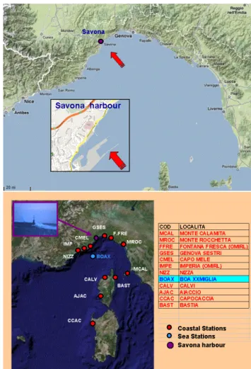
In the context of one of these meteorological situations an extreme event occurred at the Savona harbour (Fig. 1a) in the night between the 8 and 9 December 2006. During such an event the harbour’s seawall (9 m high from sea level) was overtopped by waves that damaged several structures on the docks (e.g. more than 100 cars damaged). This is the only re-ported event of this kind since 1950 (Savona Port Authority),
Correspondence to: A. Orlandi
(orlandi@lamma.rete.toscana.it)
despite the very high frequency of depressions crossing the Gulf of Genoa (about 30 a year, Trigo et al., 2002).
Hereafter we give a short description of the synoptic sit-uation of the case under study. At 00:00 UTC of the 8 De-cember 2006 northern and western Europe were under the influence of a vast low pressure system, formed by a very deep extra-tropical cyclone (964 hPa) centred between the British Isles and the Norway coasts (Fig. 2a). Central Eu-rope was affected by severe weather due to a secondary low over Britannia and the central Mediterranean sea was under the effects of a strong and extended sea level pressure gradi-ent with consequgradi-ent intense southerly winds and rough seas. During the day, as the Atlantic cyclone began to fill mov-ing towards Norway (Fig. 2b), another secondary orographic low between the Gulf of Lion and Cote D’azur began to form (Fig. 2c). By the late afternoon the secondary low, enhanced by a strong upper level jet, moved very quickly to the Gulf of Genoa deepening to around 1000 hPa at 00:00 UTC of the 9th (Fig. 2d). As a consequence of the rapid movement of the orographic low pressure system, a strong (up to 20 m/s) south-easterly flow blowing along the eastern part of the Gulf of Genoa was almost immediately followed by an equally in-tense south-westerly flow in the western part.
The Savona harbour is located in the central part of the Gulf of Genoa (Fig. 1a), where the convergence of wind regimes resulted particularly strong on 8 and 9 December,
108 A. Orlandi et al.: Case study of a flash sea storm over the Gulf of Genoa
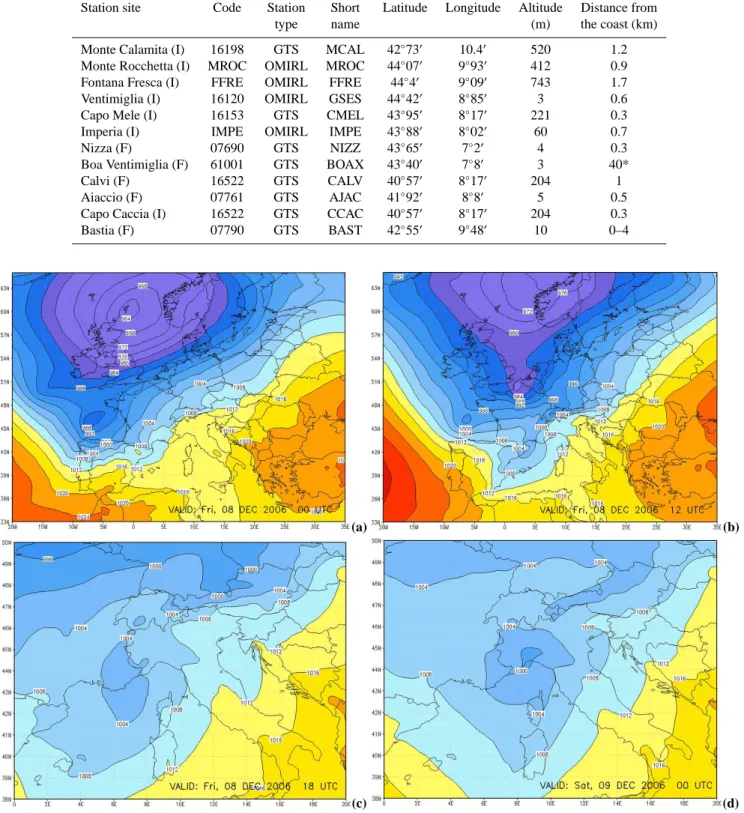
Figure 1. Map of the Gulf of Genoa (Ligurian sea, North-West of Italy) and map of Savona harbour, facing South-East (from: google-heart) (a). Map of the locations of the selected meteo-marine sta-tions (see also Table 1) (b).
with wind gusting up to 25 m/s and open water waves of more than 4 m of significant wave height. The resulting crossed sea state was characterised by a decaying rough sea from the south-east merging with an increasing south-west sea of sim-ilar magnitude.
In this work the meteo-marine conditions of the above de-scribed sea storm are studied, trough the analysis of observa-tions and high resolution numerical models results, in order to better comprehend and describe the dynamics that might have caused the event.
2 Data and methods
In the study data recorded by eleven stations of the regional surface monitoring of the ARPAL CFMI-PC (Genova, Italy) and from GTS are used to characterize the sea and wind con-ditions. Two different types of stations are considered
(Ta-ble 1; Fig. 1b): ten coastal meteorological stations (Genova Sestri – GSES – is the closest observation’s site to Savona harbour) and one offshore buoy, positioned offshore Ven-timiglia, in western Ligurian sea (Fig. 1b). Time series of sea state and wind data recorded by the stations are extracted for time windows covering the complete duration of the event.
In addition the met-ocean modelling chain of Tuscany Region Weather Service is used to study and describe the mechanisms underlying the event. The modelling chain is implemented and used for operational weather forecast-ing at La.M.Ma (Laboratory for Meteorology and environ-mental Modelling, http://www.lamma.rete.toscana.it) and is composed by a meteorological model and a wave model running in cascade. The former is the atmospheric model WRF-ARW (http://www.wrf-model.org, Janiic, 2003), at a resolution of 0.12 deg with initial and boundary conditions from NCEP-GFS (T382L64) at 0.5 deg resolution. The latter is the WW3 wave model (http://polar.ncep.noaa.gov/waves/ wavewatch/wavewatch.html, Tolman et al., 2002), running over the whole Mediterranean sea at a resolution of 0.12 deg, with a high resolution nesting (0.02 deg) over the Ligurian sea (initial and boundary conditions are from the coarse resolution WW3 and WRF-ARW). Atmospheric initial and boundary conditions for the present study are taken from the operational run of GFS of the 00:00 UTC of the 8 December 2006, as a consequence the maximum sea storm peak of the event (00:00 UTC of the 9 December) results to be at the 24th hour of model forecast.
3 Results
3.1 Observation
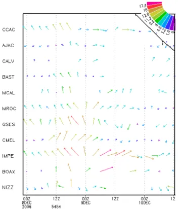
The selected meteorological stations show an overall south-easterly flow between 12:00 and 24:00 UTC of 8 December and south-westerly flow between 00:00 and 12:00 UTC of 9 December (Fig. 3), with significant wind speed of more than 15 m/s and gust up to 25 m/s (Imperia and Genova Sestri be-ing the most representative, showbe-ing that the south-east was stronger along the coast). The flow was characterized by a rapid change in wind direction (from about 135◦ to about
225◦) between 21:00 UTC of 8 December and 03:00 UTC of
the 9 December, with a strong flux convergence between a decreasing south-easterly flow and increasing south-westerly flow. Also the wind data recorded by the French buoy near Ventimiglia (located off shore to the West of Savona) show a similar sequence of different wind regimes (south-east turning south-west) with slightly higher values (20 m/s and 25 m/s) see Fig. 4.
Regarding the sea state the French buoy reported signif-icant wave height up to 3.5 m (Fig. 4) with different wave periods for the two wave components: around 6 s for the east, and 7 s for the west. In particular the south-easterly wave component shows a more rapid increase of the wave height over wave period ratio (Hs/T) with respect to the
Table 1.Most representative meteorological stations selected from GTS and the regional network of surface stations (OMIRL) for the event of 8–9 December 2006.
Station site Code Station Short Latitude Longitude Altitude Distance from
type name (m) the coast (km)
Monte Calamita (I) 16198 GTS MCAL 42◦73′ 10.4′ 520 1.2 Monte Rocchetta (I) MROC OMIRL MROC 44◦07′ 9◦93′ 412 0.9 Fontana Fresca (I) FFRE OMIRL FFRE 44◦4′ 9◦09′ 743 1.7 Ventimiglia (I) 16120 OMIRL GSES 44◦42′ 8◦85′ 3 0.6 Capo Mele (I) 16153 GTS CMEL 43◦95′ 8◦17′ 221 0.3 Imperia (I) IMPE OMIRL IMPE 43◦88′ 8◦02′ 60 0.7 Nizza (F) 07690 GTS NIZZ 43◦65′ 7◦2′ 4 0.3 Boa Ventimiglia (F) 61001 GTS BOAX 43◦40′ 7◦8′ 3 40* Calvi (F) 16522 GTS CALV 40◦57′ 8◦17′ 204 1 Aiaccio (F) 07761 GTS AJAC 41◦92′ 8◦8′ 5 0.5 Capo Caccia (I) 16522 GTS CCAC 40◦57′ 8◦17′ 204 0.3 Bastia (F) 07790 GTS BAST 42◦55′ 9◦48′ 10 0–4
(a) (b)
(c) (d)
Figure 2.Maps of mean sea level pressure from ECMWF analysis valid at 08/12/2006 06:00 (a), 12:00 (b), 18:00 UTC (c) and 09/12/2006 00:00 UTC (d). Isobars are at 4 hPa intervals.
110 A. Orlandi et al.: Case study of a flash sea storm over the Gulf of Genoa
Figure 3.Wind speed trend (in m/s) for the selected meteorological stations. X-axis: UTC time; y-axis: labels of the selected meteoro-logical stations (see Table 1 for correspondence to the names).
south-westerly regime, with a significant and rapid increase between 15:00 and 22:00 UTC of the 8 December.
3.2 Numerical simulation
The results obtained by hindcast model simulations show overall good agreement with observed data. The meteoro-logical model WRF-ARW correctly reproduces the location and time evolution of the 10 m wind speed. Wind velocity is slightly over-estimated for the south-east and slightly under-estimated for the south-west (against French buoy values, see Fig. 4). The WW3 wave model outputs reproduce the evo-lution of the two different off-shore sea states in very close resemblance with the observed one. The values of significant wave height seems over-estimated, with a greater difference for the south-west with respect to the south-east (see Fig. 5). Regarding the events occurred in correspondence of the Savona harbour, the wave model has not given a detailed re-production of the sudden and short lasting increase of sea state between 21:00 UTC of 8 and 00:00 UTC of 9 Decem-ber, with waves overtopping the seawall (9 m high) of the Savona harbour. This is probably due to the fact that the operational wave forecasting model is aimed to forecast the offshore wave conditions and the physics implemented in it can not reproduce the near shore dynamics (Brandini et al., 2006). Nevertheless interesting features emerge from a
de-Figure 4. Ventimiglia buoy (see Fig. 1 for position). Trend of recorded wind speed and windgust versus simulated model 10m wind speed. Values in m/s.
Figure 5. Ventimiglia buoy (see Fig. 1 for position). Trend of significant wave height (m) versus simulated model wave height.
tailed analysis of the temporal evolution of the directional energy spectrum computed by the wave model. In corre-spondence of a selected point offshore Savona harbour the model spectrum shows a first growing broad peak centred at about 154◦ deg between 12:00 and 23:00 UTC of 8
De-cember (Fig. 6), which suddenly splits in two much narrower peaks at 00:00 UTC of 9 December (Fig. 7). One of these two peaks corresponds to the decaying south-easterly sea, and the other growing peak corresponds to the south-westerly swell. Such a sudden change of the directional spectrum to-wards a bi-modal structure is well correlated in time with the flash rise of wave height that caused the major damages in Savona. This suggests that the causes of the event occurred in Savona could lay behind the complex hydrodynamic inter-actions between the two wave modes contemporarily imping-ing on the structures of the harbour. The spectral character-istics of storm events are recently gaining more and more at-tention also from coastal engineering community, and the bi-modal structure of the wave spectrum seems to be correlated
Figure 6.Model energy spectrum for a selected location in front of Savona harbour valid for 08/12/2006 18:00 UTC.
to more damaging conditions on beaches and coastal struc-tures (Bradbury et al., 2007).
In order to better elucidate if in this case the spectral bi-modality could be one of the causes of the event of the Savona harbour, our study will prosecute by adding other modelling stages by using high resolution coastal hydrody-namic modelling techniques (Booij et al., 1999; Copeland, 1985). In this way it will be possible to correctly represent the complex and non linear hydrodynamic interactions that could probably generate the conditions for the overtopping of a nine meter seawall (like the one in Savona) by an off-shore sea state characterised by a significant wave height of about 4 m.
In order to define a “bimodality index” (or also “multi-modality”, in the case of more than two peaks) that could be used operationally by forecasters to highlight the sea storms that could result to be the more damaging among the many occurring, the study will try to connect the modelling activi-ties with statistical correlation analysis between the spectral structure and the amount of damage caused on coastal struc-tures.
Another issue to be studied is the capability of fast moving low pressure systems to generate bi-modal sea wave spectra and hence to correlate also the time evolution of wind and pressure patterns to the occurrence of damaging conditions on the coast.
4 Conclusions
The study of a sea storm event with particular damaging consequences on Savona harbour structures, in the Gulf of Genoa (Italy) has been performed by using meteo-marine observations from coastal stations and an off-shore buoy and a meteo-marine modelling chain. Such a study showed an overall good agreement between observations and
mod-Figure 7.Model energy spectrum for a selected location in front of Savona harbour valid for 08/12/2006 23:00 UTC.
elling results, moreover the detailed study of the directional spectra computed by the wave model has shown that the most damaging conditions were characterised by a bi-modal (bi-directional) structure of wave spectra computed by the model.
This study, similarly to other recent publications, suggests that the analysis of the spectral structure of the sea state dur-ing storm events could be useful to identify the most damag-ing ones. From this point of view this study must be consid-ered a preliminary work that will prosecute by refining the modelling chain with high resolution coastal hydrodynamic models, by extending the study to other storms (in order to find statistical correlations between damaging conditions and bi-modal or multimodal spectra) and to the time evolution of wind and wave patterns generated by fast moving low pres-sure systems. The aim of the whole work is to arrive to the definition of an operational multimodality index, based on the analysis of the forecasted spectra, that could be of help to forecasters in identifying the most probably danger-ous events.
Acknowledgements. Throughout this work, we benefit from the help of our colleagues at CMIRL. Special thanks to F. Castino (for her support in graphics wind elaborations) and Alessandro Benedetti – Sasha (for his photographic contribution).
The LaMMa collaborators thank their colleagues at LaMMa-CoMMa in Livorno (LaMMa center for marine meteorology) for their contributions in the implementation and maintaining of the meteocean operational chain.
Edited by: F. Stel and D. B. Giaiotti Reviewed by: two anonymous referees
112 A. Orlandi et al.: Case study of a flash sea storm over the Gulf of Genoa
References
Booij, N., Ris, R. C., and Holthuijsen, L. H.: A third-generation wave model for coastal regions. Model description and valida-tion, J. Geophys. Res., 104(C4), 7649–7666, 1999.
Bradbury, A. P., Mason, T. E., and Poate, T.: Implications of the spectral shape of wave conditions for engineering design and coastal hazard assessment – evidence from the english channel, 10th International Workshop on Wave Hindcasting and Forecast-ing and Coastal Hazard Symposium North Shore, Oahu, Hawaii, November 11–16, abstract # J5, 2007.
Brandini, C., Ortolani, A., Giuliani, G., Orlandi, A., and Gozzini, B.: Un sistema previsionale per il monitoraggio dellerosione costiera, Atti del Simposio “Il monitoraggio costiero mediterra-neo: problematiche e tecniche di misura”, Sassari, abstract # 12, 4–6 Ottobre 2006.
Copeland, G. J. M.: A practical alternative to the “mild-slope” wave equation, Coast. Eng., 9, 125–149, 1985.
Janjic, Z. I.: A Nonhydrostatic Model Based on a New Approach, Meteorol. Atmos. Phys., 82, 271–285, 2003.
Littmann T.: An empirical classification of weather types in the Mediterranean basin and their interrelation with rainfall, Theor. Appl. Climatol., 66, 161–171, 2000.
Onorato, L., Gemelli, P., and Gallino, S.: A supervisionate classi-fication approach of south-westerly wind regime causing severe weather over the Gulf of Genoa, EMS, abstract # 35, 2006. Tolman, H. L.: A third-generation model for wind waves on slowly
varying, unsteady and inhomogeneous depths and currents, J. Phys. Ocean., 21, 782–797, 2006.
Tolman, H. L., Balasubramaniyan, B., Burroughs, L. D., Chalikov, D. V., Chao, Y. Y., Chen, H. S., and Gerald, V. M.: Develop-ment and impleDevelop-mentation of wind generated ocean surface wave models at NCEP, Weather Forecast., 17, 311–333, 2002. Trigo, I. F., Bigg, G. R., and Davies, T. D.: Climatology of
Cyclo-genesis Mechanisms in the Mediterranean, 130, 549–569, 2002.