HAL Id: hal-01374929
https://hal-inalco.archives-ouvertes.fr/hal-01374929 Submitted on 5 Oct 2016
HAL is a multi-disciplinary open access
archive for the deposit and dissemination of sci-entific research documents, whether they are pub-lished or not. The documents may come from teaching and research institutions in France or abroad, or from public or private research centers.
L’archive ouverte pluridisciplinaire HAL, est destinée au dépôt et à la diffusion de documents scientifiques de niveau recherche, publiés ou non, émanant des établissements d’enseignement et de recherche français ou étrangers, des laboratoires publics ou privés.
Systems)
Camille Fossier, Charlotte Marchina
To cite this version:
Camille Fossier, Charlotte Marchina. Study of Human-Animal Interactions in Siberian Pastoral Sys-tems via GIS (Geographic Information SysSys-tems). V.N. Davydov (�. �. �������); D.V. Arzjutov (�. �. �������). ����� �����������: ����������������� ����������� ������������ ���������� ��������� � ��������/Dimensions of social life: Anthropolog-ical perspectives on social relations and culture, 4, MAĖ RAN (��� ���), pp.613-625, 2014, ��������� �������, 978-5-88431-260-9. �hal-01374929�
Российская академия наук Музей антропологии и этнографии им. Петра Великого (Кунсткамера) СИБИРСКИЙ СБОРНИК–4 ГРАНИ СОЦИАЛЬНОГО: АНТРОПОЛОГИЧЕСКИЕ ПЕРСПЕКТИВЫ ИССЛЕДОВАНИЯ СОЦИАЛЬНЫХ ОТНОШЕНИЙ И КУЛЬТУРЫ Памяти российского этнографа-тунгусоведа Надежды Всеволодовны Ермоловой Санкт-Петербург 2014
Утверждено к печати Ученым советом Музея антропологии и этнографии имени Петра Великого (Кунсткамера) РАН Рецензенты: д.и.н. В. В. Бочаров, к.и.н. Е. Л. Капустина Ответственные редакторы: PhD, к.с.н. В. Н. Давыдов, к.и.н. Д. В. Арзютов Ответственный секретарь Е. А. Верещака Сибирский сборник–4. Грани социального: Антропологические перспективы исследования социальных отношений и культуры. (Памя-ти российского этнографа-тунгусоведа Надежды Всеволодовны Ермо-ловой) / Отв. ред. В. Н. Давыдов, Д. В. Арзютов. — СПб.: МАЭ РАН, 2014. — 726 с. ISBN 978-5-88431-260-9 Сборник включает результаты научных исследований, представленных на IX Сибирских чтениях «Грани социального: Антропологические перспективы исследования социальных отношений и культуры» (28–30 октября 2013 г., МАЭ РАН), посвященных памяти российского этнографа-тунгусоведа Надежды Все-володовны Ермоловой. Для широкого круга специалистов, занимающихся изучением Сибири. УДК 39(571.1/.5) ББК 63.5(253) © МАЭ РАН, 2014 ISBN 978-5-88431-260-9
ОТНОШЕНИЯ ЧЕЛОВЕКА,
ЖИВОТНЫХ И ЛАНДШАФТА
C. Fossier, C. Marchina
STUDY OF HUMAN-ANIMAL INTERACTIONS
IN SIBERIAN PASTORAL SYSTEMS VIA GIS
(Geographic Information Systems
1)
2Introduction
In Siberian herding practices, herders rely on the animals’ high de-gree of autonomy: generally, they pasture freely in a fenceless envi-ronment. In this context, animal loss (reindeer can escape and return to wild; sheep can mingle with neighbouring fl ocks) and attacks of predators are the main threats to the herds. How do animals occupy space in a context of autonomy? How do herders manage and control the herds’ movements? How do herders maintain the link with their animals? A detailed study of the interactions between humans and animals helps us understand how pastoral systems work. In fact, hu-man-animal interactions vary with herding strategies, the species composing the herds and environmental factors. Monitoring tools like GPSs enable the study of aspects of herding techniques poorly known
1 A geographic information system (GIS) allows to cross geographically based
data in order to create maps.
2 Fieldwork was conducted with fi nancial support from the International Research
Group “Nomadism, Society and Environment in Central and Northern Asia” (dir. C. Stépanoff), EHESS (School for Advanced Studies in Social Sciences) and INALCO (National Institute of Oriental Languages and Civilisations).
to date, providing a daily tracking of animals that are often diffi cult to observe. The integration of herders’ and animals’ trajectories in Geo-graphic Information Systems allows a simultaneous visualisation of the movements of herders and animals with respect to fi xed points or reference points — such as pastures, encampments, water sources and villages — through a cartographic representation.
Exploratory studies using GPS equipment were conducted in two very different contexts: among the Buryats of the Aga district, on sheep and cattle breeders in a steppe environment, and among the Evens of Central Kamchatka, on reindeer breeders in a tundra envi-ronment. The results of fi eldwork and recorded GPS data were pro-cessed. In addition to these case-studies, an attempt is made to pave the way for a study of human-animal interactions in pastoral practices via a geographic information system (GIS).
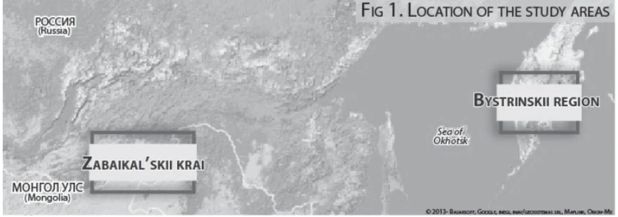
Kamchatka (Fig. 1) is a volcanic area characterised by a central mountain range. The settlement of Esso is the centre of the reindeer breeding society1 Olenevod which comprises four herds. In the
sum-mer, herders and their herds live close to the settlement located in a mountainous area, so the reindeer can pasture in altitude, escaping the heat and the mosquitoes, while the herders’ encampments are at a short distance from the source of supply. In fact, travelling is harder in the summer and requires sometimes the expensive use of a helicopter or a snow cat. In winter, three herds out of the four move almost 100 km from the village and settle in maritime tundra areas. The herders are
1 In the mid 1990’s the breeders’ societies were given the offi cial status of LLC
(Limited Liability Company), OOO in Russian.
615
then supplied by the company Olenevod by snowmobile. Snowmobiles which appeared in 1979 for reindeer herding in Kamchatka are nowa-days essential to supply the herds, herders and for transportation. In May, winter equipment is moved by helicopter to a storage place. Sum-mer nomadisation starts at the end of May/beginning of June, around the time of the last calf births. Then, the camp is moved by horse, an approximate ten kilometre distance every three days.
The Aga district (Zabaikal’skii krai) is characterized by large steppes interspersed with forest areas. Even nowadays almost each village controls an agricultural cooperative of which most of the herders are members. These herders, who do multispecies (mostly horses, sheep, cattle) extensive breeding usually develop a relative specialisation in one of the species: cattle breeders are generally established in forest areas, and sheep breeders in the steppe. Although most of the herders have a standing encampment, where they live from autumn to spring, and a lighter summer encampment for the summer, located a few kilometres from the former, and which they get to by car to fi nd fresh pastures and leave time to the vegetation near to the standing camp for regeneration, more and more herders renounce to nomadisation and tend to settle permanently on the standing camp.
In Kamchatka, GPS data was collected by Camille Fossier in 2011 during fi ve months of fi eldwork in the Bystrinskii region. A range of data was gathered in March, with the 5th brigade from LLC Olenevod
from Esso village. For one month, GPS data on herders’ movements between the camp and the herd as well as movements of the animals were collected every day. A second set of GPS data was collected in June among the 4th brigade of LLC Olenevod, by following the
nomadisation by horse during one month, as well as the movements of the herd over several periods.
Among the Aga Buryats the GPS data was collected by Charlotte Marchina in the spring and summer of 2012, during fi eldwork sessions of three and two months respectively. GPS receivers were tied to the necks of sheep and cows of breeder Dugar, employed by an agricultural cooperative, and specialised in sheep breeding. These receivers were attached for one or several consecutive days, in March, April and June. Thereby the nomadisation to the summer camp could be tracked.
The annual nomadisation trajectories are established by the LLC in Kamchatka and by the cooperative in Aga, and follow the organisation established during the soviet period. Although these trajectories are cyclic, the daily decisions concerning the moves of the herd and the nomadisation are taken individually by the chiefs of the brigades or the herders themselves, taking into account the environmental condi-tions. GPS tracking allows to give a graphical representation of these decisions in a spatial and temporal context. It allows also to character-ise the movements of the animal in response to the actions exerted by the herders on the herd. Applied to the study of herding systems, the use of GPS data allows to create representations of mobility, and, on a larger scale, when cross-referenced with data from ethnographic fi eldwork, to better understand human-animal relationships in “social-ecological systems” [Berkes, Folke 1998; cit. in: Folke 2006].
1. Methodological and technical aspects
Field observations were made and semi-directive interviews on herding techniques conducted during an immersion period among the herders. In addition to this classical survey method, the herds were observed, the vegetation photographed, to differentiate what is eaten by the herds and what is not, and the coordinates of relevant points recorded using GPS.
Two kinds of GPS receivers were used: fi rst, Garmin GPSs1, which
allow to record manually fi xed points as well as trajectories; secondly, MobileAction2 tracker GPSs, programmed to take points automatically
at regular intervals in order to generate trajectories. Garmin GPSs allowed to manually tag fi xed points such as encampments and standing camps, while tracker GPSs were tied to animals’ necks or worn by the herders, and were programmed to record the GPS position every one to three minutes, depending on the journey. With the Buryats, mainly animal movements were tracked, during one or several consecutive days, including the nomadisation to the summer encampment. Among the Evens, daily tracked trajectories of the
1 Garmin eTrex Summit and Garmin Foretrex 301. 2 IGotU Gt-120 and IGotU Gt-300.
617
herders meant meeting or moving the herds, or bringing back stray reindeer. The other tracked trajectories were those of the nomadisation, during one month, in which a tracker GPS was tied to animals during several consecutive days.
Finally, representation of the trajectories resulted in discussions with the herders, which completed our interpretations of the GPS data.
2. Defi nition of the nomadisation systems’ main spatial features
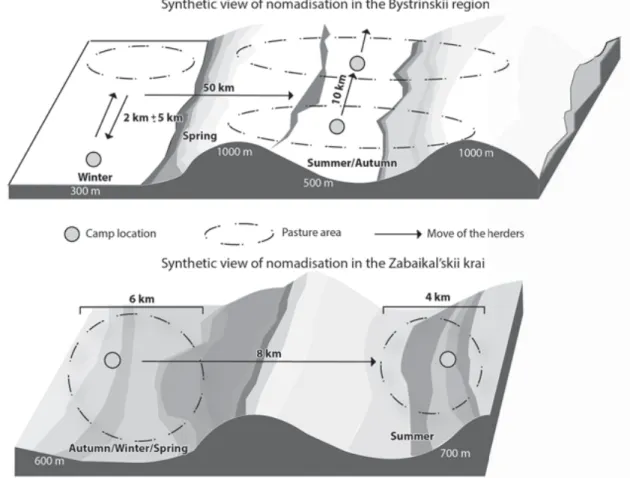
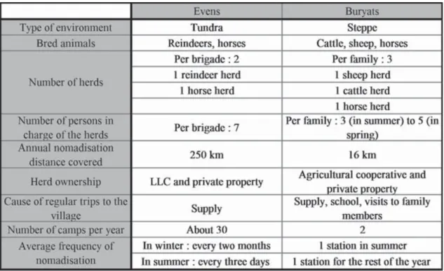
The data obtained allow to create a comparative scheme (Fig. 2) and table (Fig. 3) which synthesise the main spatial features of the herding and nomadisation system.
Fig. 2: In Kamchatka, the camp is moved every two months in
win-ter, while it is moved every three days in summer. While the herders have to make trips from the encampment to the herds and back in
Fig. 2. Illustration of nomadisation
winter, in the summer the reindeer pasture around the encampment and follow the nomadisation route.
The Buryat herders move from their almost permanent station, oc-cupied from autumn to spring, to a little summer station. In both cases, pastures are around the station.
3. Study of the pasture management and use of the environment
Location of the herders’ camps and features of the pastures
In Aga, the standing camp is located close to a river or a well, in an open plain, thereby giving the animals easy access to the pastures and a water point. In summer, the herders move to a neighbouring valley, slightly higher in altitude, also close to a river. The herders may redi-rect the sheep herd by horse several times per day, while horses and cattle pasture freely. Cattle return by themselves to the station in the evening, and horses are led to the station only once or twice a week.
Among the Evens, the yurt is set up near the river and the forest, where they take all the water and the wood they need, while the
619
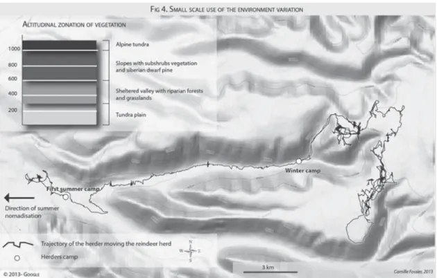
tures are located in an open environment (maritime or alpine tundra). Spring, during which the hoofs of the reindeer are still fragile after the regrowth, is a particularly delicate time in pasture management. Pas-tures must be accordingly adapted while allowing feeding with sap-lings. From the end of the winter until spring herders play on differ-ences in altitude, and thus of vegetation, by alternating between alpine tundra pastures, which form a soft pasture thanks to the water from melting snow, and valley bottom pastures, where very nourishing green saplings begin to fl ourish. On the map (Fig. 4), the trajectories located to the east of the winter camp represent the four days preced-ing the migration, when reindeer are kept on the plateaus and driven down once a day a few hours for feeding, before they are driven back up again. Because the yurt is always located in the valley, the herders take turns to join the herd on the plateau. The more experienced the herder, the more he is able to retain the reindeer and get them to rest. Two weeks before the summer nomadisation starts, two herders go and get the horses, which pasture freely in another valley for several months. They are then driven near to the camp, close to where their pasturing area will be.
Fig. 4. Small scale use of the environment variation
Delimitation of the pasture areas and environment adapted surveillance
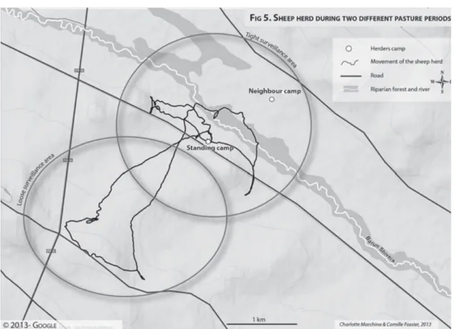
Among the Buryats, because the stations of the different herders are located quite close to each other, pasturing areas are informally delimited. Cattle and horses, rarely shepherded and often autonomous in their movements, travel great distances and sometimes mingle with neighbouring herds (cattle). Therefore, pasture area delimitation concerns mainly the sheep, which pasture around the encampment. In absence of fences (the only fences to be found are intended to protect cultivated areas or fodder stocks) grazing areas are implicitly delimited in agreement with the neighbours. Some of the borders are not visible, while others rely on landscape elements such as roads or rivers. Parts of these borders are known by the sheep themselves, which they do not transgress then. When Dugars’ sheep (Fig. 5) graze along the roads, south-west of the encampment, they are less watched (the trajectories of the fl ock are straighter) because the animals know the limits of their pasture and also because there are no neighbours in the surrounding area. On the other hand, when they are in the
621
east, in the area of the river, where they might mingle with the neighbours’ fl ock, they are watched closer and redirected. In all cases, the steppe environment allows a remote surveillance by binoculars, which allow the herders to move only when an intervention is necessary.
In Kamchatka, reindeer are looked after only in the morning during winter. From May, when calve births begin and the bears wake up from their winter sleep, reindeer are looked after day and night. The surveillance is adapted according to the landscape confi guration: in the 4th brigade three reindeer wear a bell, so the movements of the herd
can be perceived in spite of the dense vegetation. In open areas, the herders keep an eye on the herds with binoculars, evaluating their position in regard to the place they were left at the day before. In alpine tundra, the borders of the plateau form a way of “indirect” control of mobility [Ferret 2007: 59] in containing the herd.
4. Analysing animals and humans movements to better understand human-animal interactions
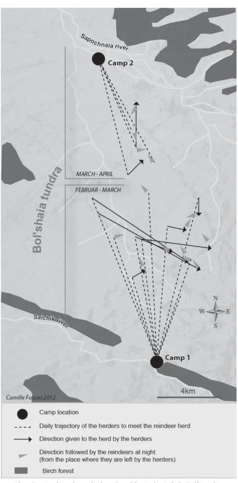
Analysing the differences in the herder’s movements around the herd in Kamchatka shows different herding strategies, linked to the issues of the season. In fact, whereas the herder has to drive the ani-mals and urge their move in winter, in order to lead them to the good pastures known by the humans, he has on the contrary to restrain the herd in spring, by placing himself on its sides or at its front in order to get the animals to rest and curb its movements, so the distance from the yurt is not too far. Although generally speaking the nomadic route is the same every year the chosen grazing areas are changed, accord-ing to the climatic and environmental conditions (usually a few kilo-metres from that from the year before). The herders come back to the very same location every three to fi ve years. The oldest reindeer, espe-cially the females, can thus remember the locations, espeespe-cially impor-tant places such as calving places. The map (Fig. 6) shows the move from the camp 1 to the calving place (camp 2), used fi ve years before. The reindeer tend to follow by themselves the direction of camp 2. When they move too far away from camp 1 (that is more than 3 to 5 km, where the grazing area is) the reindeer are redirected. Once the
623
humans decide to nomadise, after consideration of the state of the rein-deer and of the climatic and environmental conditions, the reinrein-deer are left free to move by themselves to the calving place.
In Aga, the summer of 2012 was characterised by late rains, and thus late vegetation growth, delaying the summer nomadisation by almost one month, in comparison to the previous years. Before the effective nomadisation, cattle moved spontaneously to the summer camp, forcing the herders, who decided it was too soon to move, to get them back to the standing camp. A couple of days before the effective nomadisation, cattle were urged by foot in the direction of the summer camp, as though they were notifying them that the nomadisation would imminently take place. On June 17th the sheep were led by one of the
herders by horse to the summer camp, and accomplished the journey in around three hours. The next day, the rest of the herders moved in twenty minutes by car to their summer camp, following another path. The same day, on their own initiative, the cattle also moved to the summer camp following a third path, in about eight hours, while graz-ing. The map (Fig. 7) shows that whilst the sheep are urged by the herder during nomadisation, the average speed is twice as fast as dur-ing grazdur-ing, while on the other hand cattle movdur-ing is at its usual speed.
Fig. 7. Timescale of movement for two different species
In both cases, Even and Buryat, the animals “internalised” the routes on a spatial and temporal level, thereby forcing the herders to place “their new desires”(which here concerns the schedule) “in op-position to that of the herd which stubbornly adheres to the herders’ former desires” [Beach, Stammler 2006: 7]. This helps bringing out the dynamic aspects of the human-animal relationship, in a permanent “mutual adaptation” [Istomin, Dwyer 2010].
Conclusions
First, using geo-referenced data offers the possibility of a methodi-cal and regular monitoring of mobilities, allowing comparisons within a single herd but also, on a broader scale, among different breeding communities. Beside the above results, it also allows a clear identifi ca-tion of the common usage of pasture areas, whether between different species or different herders (see Fig. 7), of the differences in animal behaviour depending on the season and vegetation, and also of the degree of freedom of the animals, analysed through their response to human constraints of varying severity.
Further, it enables the understanding of the dynamic aspects of man to animal relationships, both in space and in time, in social-ecological systems characterised by important mutual retroactions [Folke 2006: 262; Istomin, Dwyer 2010].
This constitutes only the fi rst step of the methodology, and it would be of crucial importance, for example, to fi ne tune the choice of the animal on which to place the GPS receivers in order to highlight the role they play within the herd [Stépanoff 2012: 300], or even to perceive the organisation of the movements within the herds.
Bibliography
Beach H., Stammler F. Human-Animal Relations in Pastoralism //
No-madic Peoples. 2006. № 10 (2). P. 6–29.
Ferret C. Les Iakoutes, des chercheurs de chevaux // Ethnozootechnie.
2007. № 80. P. 51–63.
Folke C. Resilience : The emergence of a perspective for
social-ecologi-cal systems analyses // Global Environmental Change. 2006. № 16. P. 253– 267.
625 Istomin K. V., Dwyer M. J. Dynamic Mutual Adaptation: Human-Animal
Interaction in Reindeer Herding Pastoralism // Human Ecology. 2010. № 38. P. 613–623.
Stépanoff C. Human-animal “joint commitment” in a reindeer herding
system // HAU: Journal of Ethnographic Theory. 2012. № 2 (2). P. 287–312.
Аbstract
In this article we propose an exploratory study of human-animal relations via GIS (Geographic Information Systems) among two dif-ferent nomadic pastoral populations — the Buryats of the Aga district (Transbaikalia) and the Evens of Central Kamchatka. In this research, we used GPS receivers, which allowed us to produce a geographic location of the data and to represent on maps the herders’ and ani-mals’ movements with respect to fi xed reference points (pastures, en-campments, etc.), allowing a new approach in the study of human-animal interactions.
животными с помощью ГИС (географическая информационная система) у двух кочевых народов — Агинских бурят Забайкальского края, и эвенов Быстринского района Камчатского края. В исследовании был использован GPS-приёмник, который дал возможность произвести географическую локализацию данных, изобразить на карте передвижения скотоводов и животных в отношении к неподвижным точкам (пастибще, стоянка и пр. …), а так же взаимодействия человека с животными. !