HAL Id: ineris-01862559
https://hal-ineris.archives-ouvertes.fr/ineris-01862559
Submitted on 27 Aug 2018HAL is a multi-disciplinary open access archive for the deposit and dissemination of sci-entific research documents, whether they are pub-lished or not. The documents may come from teaching and research institutions in France or abroad, or from public or private research centers.
L’archive ouverte pluridisciplinaire HAL, est destinée au dépôt et à la diffusion de documents scientifiques de niveau recherche, publiés ou non, émanant des établissements d’enseignement et de recherche français ou étrangers, des laboratoires publics ou privés.
Induced micro-seismicity by flooding of the abandoned
Gardanne coal basin (Provence, France): analysis and
interpretation
Emanuela Matrullo, Isabelle Contrucci, Pascal Dominique, Pascal Bernard,
Hideo Aochi, Mustapha Bennani
To cite this version:
Emanuela Matrullo, Isabelle Contrucci, Pascal Dominique, Pascal Bernard, Hideo Aochi, et al.. In-duced micro-seismicity by flooding of the abandoned Gardanne coal basin (Provence, France): analysis and interpretation. French-Japanese symposium an earthquakes & triggered hazards, Sep 2015, Or-léans, France. pp.79-81. �ineris-01862559�
Induced micro-seismicity by flooding of the abandoned
Gardanne coal basin (Provence, France): analysis and
interpretation
Emanuela Matrullo (1), Isabelle Contrucci (1), Pascal Dominique (2), Pascal Bernard (3), Hideo Aochi (2) and Mustapha Bennani (1)
(1) INERIS - Institut national de l'environnement industriel et des risques (Nancy, France). e-mail: emanuela.matrullo@ineris.fr, Tel. +33-3-54406629
(2) BRGM - Risk and Prevention division (Orleans, France) (3) IPGP - Institut physique du globe (Paris, France)
Mining activity in Provence has left many underground voids that can cause land subsidence or collapses in areas of high population density. Part of these underground voids are now flooded and causes seismicity, whose strongest events were felt by the population. To mitigate these risks, a realtime microseismic monitoring was implemented in sensitive areas. Since the cessation of mining concessions in Provence, INERIS (Institut National de l'Environnement industriel et des RISques) has installed 5 permanent microseismic monitoring networks in the Gardanne coalfield which was operated by Charbonnages de France (Figure 1). Then, BRGM-DPSM (Bureau de Recherche Géologiques et Minières – Département Prévention et Sécurité Minère) on behalf of the State, asked INERIS to continue this microseismic monitoring.
The flooding of mine voids and fluctuations of the groundwater level induced many seismic events that have been recorded since the beginning of operational monitoring. An example is the seismic crisis of November 2012, where magnitude events > 2.5 were felt by the population (Dominique, 2014; Contrucci et al 2013; Bennani, 2012). In 2013, 5 temporary seismic stations were deployed by the BRGM-DPSM specifically to monitor the activity of that particular area. Early 2014, due to an exceptionally high rainfall and achieving maximum pumping capacity in the mining area, the groundwater level of the mining reservoir rises rapidly. To anticipate the possibility of a renewed seismic activity, a temporary seismic network of 5 new stations was deployed by INERIS, to complete the coverage of the existing network. Thus, the Gardanne coal basin is now monitored by five permanent microseismic stations and 10 temporary seismic stations (Figure 1). In December 2014, a new microseismic crisis was felt by people leaving in the area. The question of events induced by the mine and flooding, or triggered events with fault re-activation, or natural events is asked. Depending on the response, the estimate of the likely maximum magnitude in the mining area may differ significantly.
In this context, the objective of this work is to engage in-depth analyses by taking advantage of the temporary network to understand the mechanisms of the observed seismicity. This will include clarifying the relationships between seismicity and rising waters in old mine working, geology and local tectonics. Outstanding questions to be answered are multiple:
how to differentiate events induced by flooding of the mine, triggered events (remobilization of faults) or natural?
what are the mechanisms involved?
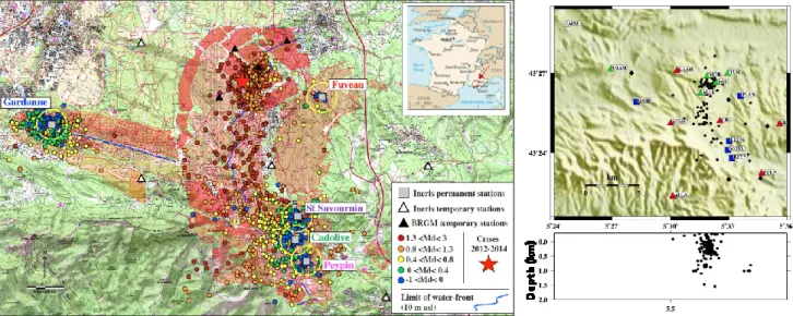
Figure 1: left : Map of the seismicity from 2008 to 2014 detected and located by the permanent
seismic network represented by grey square. The colours of the circle are related to the duration magnitude taken from the catalogue. Several symbols are used for the different networks present in the area. The yellow circle represents the risk area of 400m around the stations. The limit of the waterfront is also represented with a blue line. The red zone represents the extension of the “Grande mine” mine working layer. Right : preliminary location of the microseismic events using permanent and temporary seismic network, plan and depth views.
To answer these questions, we focus on the spatio-temporal distribution of the seismic events which allows monitoring the dynamics of faulting and to estimate the extension of the fracture system. Preliminary locations from the real-time permanent network of the seismic events show that this activity is mainly related to the fluctuations of the mine water level (Figure 1-Left). Note that this network is not design to monitor the centre of the basin. The location made using temporary stations, allow refining these locations, especially in depth, using a multilayered 1D velocity model (Figure 1 – right). According to location errors, which are estimated around 500 meters, a pattern of seismic foci are observed between 0 and 500 meters of depth, which may correspond to the depth of “Grande Mine” layer. A deeper pattern, below 500 m depth, is also observed and may be associated to a deeper geological structure of the site, as a fault. Expected main orientation of the fracture in this area is NE-SW (Gaviglio, 1985) as the orientation of the mine pillar, observed on old mine plan, are NW-SE. Both directions are observed in seismic locations and need to be confirmed by a more detailed analysis.
Some preliminary analysis on the Vp/Vs ratio and P-wave velocity model was performed. The high Vp/Vs (1.8) and the 1D velocity model we found, reveal and confirm the presence in the area of aliestones formation partially fracturated and partially saturated of water. Very small station residuals (between -0.05 and 0.05) are apparently related to the geometry of the minelayer. This observation suggest a more detailed analysis on the geometry of the velocity models in order to better understand the influence of 3D geometry of the Grande Mine workings on the earthquake location.
The determination of the rupture mode (focal mechanisms) of the events is also an important information to characterize the stability of the abandoned mine. This work is under processing using innovative approach developed for cluster analysis (Kinscher, 2015).
References
Bennani, M., 2012. Note d’expertise complémentaire relative aux événements microsismiques ressentis en surface dans la zone de Fuveau – Gréasque, dans le bassin minier de Gardanne., note INERIS DRS_12-126881-12578A.
Contrucci, I., Bennani, M., Bigarré, P. & Dominique, P., 2013, Activité microsismique et caractérisation de la détectabilité des réseaux de surveillance du bassin houiller de Gardanne, AGAP 2013, Nancy.
Dominique, P., 2014. Analyse préliminaire de la crise sismique de Fuveau (Bouches-du-Rhones), BRGM/RP-63592-FR.
Kinscher, J, 2015, The analysis and interpretation of microseismicity induced by a collapsing solution mining cavity, thèse de doctorat, Université de Lorraine.
GAVIGLIO P., 1985. La déformation cassante dans les calcaires fuvéliens du bassin de l’Arc. Comportement des terrains et exploitation minière, Thèse de Doctorat d’Etat, Université de Provence, 219 p.