HAL Id: hal-00299326
https://hal.archives-ouvertes.fr/hal-00299326
Submitted on 9 Nov 2005
HAL is a multi-disciplinary open access
archive for the deposit and dissemination of
sci-entific research documents, whether they are
pub-lished or not. The documents may come from
teaching and research institutions in France or
abroad, or from public or private research centers.
L’archive ouverte pluridisciplinaire HAL, est
destinée au dépôt et à la diffusion de documents
scientifiques de niveau recherche, publiés ou non,
émanant des établissements d’enseignement et de
recherche français ou étrangers, des laboratoires
publics ou privés.
The long-term development of avalanche risk in
settlements considering the temporal variability of
damage potential
S. Fuchs, M. Keiler, A. Zischg, M. Bründl
To cite this version:
S. Fuchs, M. Keiler, A. Zischg, M. Bründl. The long-term development of avalanche risk in settlements
considering the temporal variability of damage potential. Natural Hazards and Earth System Science,
Copernicus Publications on behalf of the European Geosciences Union, 2005, 5 (6), pp.893-901.
�hal-00299326�
SRef-ID: 1684-9981/nhess/2005-5-893 European Geosciences Union
© 2005 Author(s). This work is licensed under a Creative Commons License.
and Earth
System Sciences
The long-term development of avalanche risk in settlements
considering the temporal variability of damage potential
S. Fuchs1, M. Keiler2, A. Zischg3, and M. Br ¨undl4
1alpS Centre for Natural Hazard Management, Innsbruck, Austria
2Department of Geography and Regional Research, University of Vienna, Austria 3Geo Information Management, Gargazzone, Italy
4WSL Swiss Federal Institute for Snow and Avalanche Research SLF, Davos, Switzerland
Received: 7 September 2005 – Revised: 3 November 2005 – Accepted: 3 November 2005 – Published: 9 November 2005 Part of Special Issue “Multidisciplinary approaches in natural hazard and risk assessment”
Abstract. Recent studies on the avalanche risk in alpine settlements suggested a strong dependency of the develop-ment of risk on variations in damage potential. Based on these findings, analyses on probable maximum losses in avalanche-prone areas of the municipality of Davos (CH) were used as an indicator for the long-term development of values at risk. Even if the results were subject to significant uncertainties, they underlined the dependency of today’s risk on the historical development of land-use: Small changes in the lateral extent of endangered areas had a considerable im-pact on the exposure of values. In a second step, temporal variations in damage potential between 1950 and 2000 were compared in two different study areas representing typical alpine socio-economic development patterns: Davos (CH) and Galt¨ur (A). The resulting trends were found to be sim-ilar; the damage potential increased significantly in number and value. Thus, the development of natural risk in settle-ments can for a major part be attributed to long-term shifts in damage potential.
1 Introduction
During the last decades, compensations for damage paid out by insurance companies due to harms resulting from nat-ural hazards increased world-wide (e.g. MunichRe, 2005a, b). A similar trend could be observed in alpine countries on a regional level, recent examples affecting settlements and threatening traffic lines include the avalanche winter 1999 and the inundations in 2000, 2002 and 2005. This devel-opment illustrates the need for a sound, precautionary and sustainable dealing with natural hazard phenomena, taking
Correspondence to: S. Fuchs
into consideration both, the processes and the values at risk (Benson and Clay, 2004; Dilley et al., 2005).
Risk resulting from natural hazards is defined as a func-tion of the probability of a hazard process and the related extent of damage (Eq. 1). In accordance with the definition of United Nations (2004), specifications for the probability of the defined scenario (pSi), the value of the object affected by this scenario (AOj), the probability of exposure of object
j to scenario i (pOj,Si), and the vulnerability of object j in dependence on scenario i (vOj,Si)are required for the quan-tification of risk (Ri,j).
Ri,j =pSi·AOj·pOj,Si·vOj,Si (1)
However, until now, there have only been few studies related to the development of risk resulting from natural hazard pro-cesses over time (Wilhelm, 1997; Fuchs et al., 2004; Zischg et al., 2005a, b). An increased use of hazard-prone areas for settlement and infrastructure has been assumed to be respon-sible for an increased risk and resulting losses during peri-ods of high hazard activity (see e.g. Ammann, 2001; Bar-bolini et al., 2002), particularly concerning avalanche haz-ards. Since (1) the natural avalanche activity seemed to be constant during the last 50 years (Laternser and Schneebeli, 2002) and (2) the avalanche run-out areas were reduced due to the construction of permanent mitigation structures in the release areas, this assumption could be explained by (3) long-term shifts in the damage potential. Analysing this assump-tion within a field study in the municipality of Davos (CH), Fuchs et al. (2004) conclude that in general, the risk resulting from avalanche hazards decreased fundamentally since 1950. However, high ranges occurred during the sets of calculation. Small variations in the run-out lengths of the avalanche sce-narios resulted in high scattering in the risk analyses, which provides evidence for the particular influence of the damage potential on the quantification of risk.
894 S. Fuchs et al.: Temporal variability of damage potential in settlements
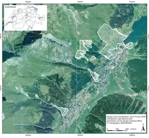
Fig. 1. Study area in the municipality of Davos. The hatched raster represents the avalanche run-out areas (scenario2000). Vertical hatching corresponds to the red hazard zone (30-year scenario), horizontal hatching to the blue hazard zone (300-year scenario), and angular hatching to the yellow hazard zone (run-out area of powder snow avalanches). For explanations regarding hazard zoning in Switzerland, see the Appendix.
Table 1. Parameters distinguishing the study areas in Davos (CH)
and Galt¨ur (A).
Area (km2) Inhabitants Tourists
Davos (1560 m a.s.l.) 254 13 000 45 000
Galt¨ur (1580 m a.s.l.) 121 770 4000
The objective of this study is to highlight these ranges and to contribute to a discussion focusing on the significance of damage potential when carrying out long-term risk analyses related to natural hazards. The spatial sensitivity of the re-sults is discussed. First, the development of probable maxi-mum loss is presented for a case study carried out in Davos (CH) related to avalanche risk. Second, the development of values at risk in the municipality of Davos (CH) is compared to a similar study carried out in the municipality of Galt¨ur (A). Both municipalities represent typical alpine villages pendent on winter tourism, thus, the results mirror recent de-velopments in damage potential in alpine destinations.
The municipality of Davos is the largest municipality in the canton of Grisons in Switzerland (Fig. 1) and covers an
area of 254 km2. In 2000, approximately 13 000 inhabitants lived in Davos, and up to 45 000 tourists were present during winter time (BfS, 2001, see Table 1). The altitude of the city centre is situated at 1560 m a.s.l., which illustrates its suscep-tibility to avalanche hazards. The centre of Davos is exposed to four main avalanche paths which are almost completely equipped with snow supporting structures in the release ar-eas.
The municipality of Galt¨ur is located 50 km north-east of Davos in Tyrol, Austria, at an altitude of 1580 m a.s.l. The municipality covers an area of 121 km2and 770 inhabitants lived there in the year 2000 (Landesstatistik Tirol, 2004, see Table 1). During winter time, up to 4000 additional per-sons were counted living in the hotels and guest houses of the village (Gemeinde Galt¨ur, 2003). Galt¨ur is endangered by 26 avalanche paths, nine of which are equipped with de-fence structures in the starting zone. Major avalanche dams protecting the centre of Galt¨ur were constructed after the avalanche event of 1999.
2 Development of probable maximum loss in Davos
This study aims to contribute to the discussion on develop-ment of risk over time. It focuses on the relative comparison
of different system conditions resulting from socio-economic changes in alpine environments. The probable maximum loss (PML) resulting from avalanches in the year 1950 was compared to the remaining PML in 2000, considering tech-nical mitigation measures implemented during the same pe-riod. Establishing the PML determines the upper boundary of risk related to a worst-case scenario. This originally ac-tuarial approach identifies the largest potentially assumable loss. To calculate the PML, according to Equation 1, data related to the process and to the values at risk are needed.
2.1 Methods
Changes in the extent of the avalanche accumulation areas were studied using the numerical avalanche model AVAL-1D (e.g. Christen et al., 2002a) in combination with the
avalanche incident cadastre of former events. AVAL-1D
is a one-dimensional avalanche dynamics program for the prediction of run-out distances, flow velocities and impact pressure of both dense flow and powder snow avalanches. The dense flow simulation is based on a Voellmy-fluid flow law, while the powder snow simulation follows Norem’s de-scription of powder flow avalanche formation and structure (Norem, 1995). The avalanche calculation is based on a dry-Coulomb type friction (µ) and a velocity squared friction (ξ ) and was carried out following the guidelines given in the manual (Christen et al., 2002b). The fracture depths were ob-tained using Gumbel’s extreme value statistics on the possi-ble maximum new snow heights within three days. The input parameters were calibrated on the basis of the legal hazard map.
The values at risk were obtained analysing the zoning plan, which was provided by the municipal administration of Davos. This plan contains detailed information about the location and perimeter of every building. Additional infor-mation, such as year of construction, type and replacement value were provided by the land registry office and analysed using GIS. The number of endangered permanent residents was derived from the number of domiciles. Statistics indi-cated 3.6 persons per unit in the year 1950 and 2.4 per unit in the year 2000 (Ritzmann-Blickenstorfer, 1996; BfS, 2001). The number of exposed persons in hotels, guest houses and hospitals was quantified by the number of beds, multiplied by the degree of utilisation. To account for the employees working in hotels and hospitals the number of beds was in-creased by 20% (Davos Tourist Board 2002, pers. comm.) and 70% (BfS, 2002), respectively.
The vulnerability of buildings and persons as well as their probability of presence was considered in terms of PML, which traces back to actuarial procedures and is the largest potentially assumable loss. Following these ideas, the to-tal avalanche run-out areas were considered when calculating the values at risk. The cumulative PML for the areas endan-gered by avalanches in the year 1950 was compared to the year 2000: First, the values at risk were quantified for the year 1950. Second, the values at risk for the year 2000 were calculated under consideration of a reduction of the run-out
areas due to the construction of permanent mitigation struc-tures, such as snow fences in the avalanche starting zones. The development of PML resulted from the comparison be-tween the initial state in the year 1950 and the state in the year 2000, including the aggregation and expansion of val-ues at risk during the same period.
The modelling of avalanche scenarios is affected by un-certainties resulting from model parameters on the one hand and from input parameters on the other hand. Following a suggestion outlined in Barbolini et al. (2002), the range re-sulting from those uncertainties was calculated on the basis of a confidence interval of 95%. Thus, as an example, the 30-year event was calculated with a range in the run-out length of ±20 m, and the 300-year event with a range of ±30 m.
2.2 Results
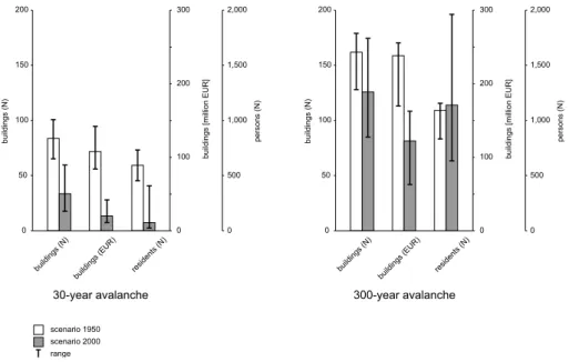
Based on the methods outlined above, the PML in areas af-fected by avalanches was determined for the municipality of Davos. The result section focuses on the relatively frequent event of a 30-year avalanche scenario and the relatively rare event of a 300-year avalanche scenario because these scenar-ios represent the outline of the red and blue hazard zone in Switzerland (see the Appendix), and they represent the typi-cal problems when dealing with design events in the area of risk analyses resulting from alpine hazards. Thus, emerging problems could be well demonstrated.
In the year 1950, 83 buildings with a total replacement value of approximately EUR 107.6 million had been located inside the run-out areas affected by a 30-year avalanche sce-nario (Fig. 2, Table 2). In the year 2000, 33 buildings with a replacement value of EUR 19.3 million were situated in-side the area affected by a 30-year avalanche, which is nearly 40% in number and 18% in value of the 1950s calculation. The endangered residential population amounted to 591 per-sons living in the area of a 30-year avalanche run-out zone in 1950. In 2000, in consequence of the construction of per-manent mitigation measures, 87 residents remained exposed, which is an 85% reduction of PML. However, the range of these results was considerable: Inside the areas of a 30-year avalanche event, the number of buildings scattered almost 25% in number and value for the scenario 1950 and 50% for the scenario 2000. Concerning residential population, the values ranged from ±20% for the scenario 1950 to a remark-able factor of around 450% for the scenario 2000. Gener-ally, the PML inside areas affected by a 30-year avalanche decreased regarding the exact values as well as the mini-mum and maximini-mum values for the number and value of en-dangered buildings and for the number of affected persons. Compared to the results of the 300-year avalanche scenario, those values were relatively small.
Inside areas affected by the 300-year avalanche scenarios, a total of 161 buildings with a replacement value of almost EUR 240 million were located in the year 1950 (Fig. 2, Ta-ble 2). In the year 2000, an amount of 125 buildings with a total value of almost EUR 122 million remained endangered, including 28 buildings that had been constructed in the
pe-896 S. Fuchs et al.: Temporal variability of damage potential in settlements 0 100 200 300 0 50 100 150 200 buil dings (N) buildi ngs [m ill ion EUR] 0 500 1,000 1,500 2,000 persons (N) buildings (N)
buildings (EUR) residents (N)
0 100 200 300 0 50 100 150 200 buil dings (N) buil dings [mi llion EUR] 0 500 1,000 1,500 2,000 persons (N) buildings (N)
buildings (EUR) residents (N)
scenario 1950 scenario 2000 range
30-year avalanche 300-year avalanche
Fig. 2. Scenario1950and scenario2000resulting from 30-year and 300-year avalanche events in the municipality of Davos (CH), and associ-ated uncertainties following the suggestions outlined in Barbolini et al. (2002). For the 30-year scenario, the ranges regarding the buildings are relatively similar, while the range resulting from the residents in the year 2000 is remarkably high. For the 300-year scenario in the year 2000, the highest range occurred within the category of endangered residential population, while the lowest variations were found for the number of buildings.
Table 2. Probable maximum loss in Davos related to the 30- and the 300-year scenario.
1950 2000
Buildings Residents Buildings Residents
N M EUR N N M EUR N
30-year scenario 83 107.6 591 33 19.3 87
300-year scenario 161 239.4 1098 125 121.8 1137
riod before 1950 and 97 buildings that were constructed be-tween 1951 and 2000. Thus, the 2000s results correspond to almost 78% in number and around 50% in value of the 1950s calculation. Inside the areas of the 300-year avalanche scenarios, 1098 residents lived in the year 1950. In the year 2000, this value increased slightly to 1137 persons. In com-parison to the areas affected by the 30-year avalanche scenar-ios, the range – in absolute numbers – is significantly higher. Regarding the 300-year avalanche events, the values of the scenario 2000 scattered remarkably higher than those of the scenario 1950. The highest range was found in the category of residents for the scenario 2000, were the number ranged from 636 to 1971 persons. Particularly in the category of residential population it became evident that the range of the scenarios was higher than the difference between the sce-nario 1950 and the scesce-nario 2000.
Regarding temporal population in hotels, guest houses and hospitals, the 1950s scenario of the 300-year avalanche events included 1041 guest beds in accommodation facilities and 1851 beds in hospitals. Applying an average rate of util-isation of 60% (Davos Tourist Board 2002, pers. comm.)
to hotels and 83.7% to hospitals (Kurverein Davos, 1951), 625 guests in accommodation facilities and 1550 patients in hospitals remained vulnerable. Including labour force, these numbers account to 750 persons and 2590 persons, respec-tively. In the year 2000, 81 guests remained in the category of hotels and guest houses. Assuming an utilisation of 60% during the winter season and including employees, 59 per-sons were endangered. Hospitals were no longer endangered.
2.3 Conclusions
In the previous sections, the development of PML between 1950 and 2000 was presented for the municipality of Davos (CH). Based on the assumptions outlined in the methods section, the PML decreased remarkably for both, areas af-fected by 30-year avalanches and areas afaf-fected by 300-year avalanches. The sole exception was in the category of res-idents within the 300-year scenario, where an increase in PML was verifiable. The associated range was consider-able, resulting from a dense utilisation of development land in the studied area. Small variations in the extent of the
ac-cumulation areas (±20 m for the 30-year avalanche events and ±30 m for the 300-year avalanche events) demonstrated a significant importance of the temporal and spatial analysis of values at risk.
The investigation provides specific information regarding the development of avalanche risk in the municipality of Davos (CH), based on analyses of PML. General statements referring to a larger area (canton, country) might be difficult to deduce, since small-scale land-use disparities have a sig-nificant influence on the diversification of risk. The spatial distribution of damage potential is substantially influenced by the historical growth of settlements on the one hand and spatial planning issues on the other hand. When analysing the development plan, this could be proven by relatively larger buildings downwards the slope and smaller build-ings upwards the slope, representing the respective buildbuild-ings codes and the underlying admissible floor space indices.
In addition to the described range of the results from the analyses on PML, several inherent uncertainties regarding the application of the risk equation (Eq. 1) should be con-sidered when analysing risk over time:
1. Regarding the probability of presence (pOj,Si)of en-dangered persons, the question is how to determine their number at the specific time of occurrence of an avalanche event. The permanent residential population could be empirically determined using the average num-ber of persons per domicile. The temporally variable number of persons in hotels and hospitals could be ap-proximated using the number of beds and the corre-sponding average utilisation. Concerning infrastructure facilities, such as buildings of the public sector or ca-ble car stations, such statistics are for the most part not available. Thus, high uncertainties should be taken into consideration when assessing the probability of pres-ence of endangered persons, or the calculation should be a priori carried out using a value in terms of an upper limit. Furthermore, the spatial probability of presence is subject to considerable temporal changes, as presented by Keiler et al. (2005).
2. Further uncertainties are connected to the vulnerability factor (vOj,Si). Concerning the vulnerability of build-ings towards the impacts of avalanches, consolidated findings allowing for a spatial application are still miss-ing (IUGS, 1997; J´onasson et al., 1999; Keylock and Barbolini, 2001). Assumptions, as for example pre-sented in Wilhelm (1997), can only partly contribute to this problem. Future research is needed to obtain signif-icant empirical data on the relevant parameters for the determination of the vulnerability of buildings.
3. Moreover, future research concerning the behaviour of avalanches in the accumulation areas is needed, espe-cially related to the structure of buildings. Buildings can have similar effects on avalanches as avalanche retard-ing mounds. Due to a shift in the buildretard-ing pattern within the accumulation area, buildings oriented towards the
valley bottom tend to result in smaller risk than build-ings that are located closer towards the transit area. In-dependently from the related political implications and the associated impacts on land-use planning, further in-vestigations on this effect should be carried out, because of the probable reduction of the accumulation areas and, as a consequence, the resulting risk.
Independent from these methodical restrictions resulting from the application of the risk equation (Eq. 1), trends aris-ing from the shifts in damage potential should be taken into consideration, leading to an enhanced understanding of the long-term development of risk in settlements.
3 Development of damage potential in Davos
and Galt ¨ur
Apart from today’s land-use regulations and the associated legal fundamentals, land utilisation and building develop-ment is based on historical settledevelop-ment growth and result-ing land-use patterns. For this reason, detailed studies on the spatial distribution of values at risk are major issues in dealing with risk, particularly for tourism-dependent munic-ipalities, as stated in Keiler (2004) for the municipality of Galt¨ur (A) and Fuchs and Br¨undl (2005) for the municipal-ity of Davos (CH). However, only few approaches and con-ceptual proposals describe the determination of damage po-tential, focusing more on fatalities and direct damage cost of specific events than on methodological issues. Related to set-tlements, early studies by Bj¨ornsson (1980) and more recent studies by Glade and Crozier (1996), J´ohannesson and Ar-nalds (2001), Stethem et al. (2003), Kleist et al. (2004) and Merz et al. (2004), have to be mentioned.
Due to the lack of comparative studies, additional anal-yses concerning the temporal development of damage po-tential have been carried out in the municipality of Galt¨ur (Keiler, 2004). Results from both of the municipalities based on areas affected by avalanches are presented in the follow-ing sections. Focusfollow-ing on emergfollow-ing trends in the develop-ment of damage potential, the comparative study deliberately neglects different legal land-use and planning regulations in the two alpine countries.
3.1 Values at risk in Davos
The number and value of buildings in the studied area rose considerably between 1950 and 2000 (Fig. 3, Table 3). The total number of buildings has almost tripled, from 161 in 1950 to 462 in 2000. This increase was due to the shift from 51 to 256 in the category of residential buildings, while in the other categories of buildings the number of buildings was approximately unchanging. A significant increase in number dated back in the 1960s and 1970s before the legally hazard map came into force (Fuchs and Br¨undl, 2005).
The total value of buildings increased by a factor of almost four. In 1950, the total sum of insured buildings was EUR 240 million and in 2000, the total sum was EUR 930 million.
898 S. Fuchs et al.: Temporal variability of damage potential in settlements 1,000 0 500 million EUR 1960 1970 1980 1990 2000 1950 500 0 250 number hotels/guest houses residential buildings commercial buildings other buildings special risks agricultural buildings Davos 0 60 1960 1970 1980 1990 2000 1950 100 0 50 40 20 Galtür
Fig. 3. Development of damage potential in Davos (CH) and Galt¨ur (A) related to the respective avalanche-prone areas, subdivided in
decades and building functions.
Table 3. Values at risk in Davos.
1950 1960 1970 1980 1990 2000
Building categories N k EUR N k EUR N k EUR N k EUR N k EUR N k EUR
Residential 51 34 980 85 62 145 158 160 951 206 312 127 236 385 881 256 428 972
Agricultural 13 4589 13 4589 16 5166 16 5166 16 5166 16 5166
Special risk 14 46 833 16 48 393 20 87 199 22 95 457 23 99 611 24 100 229
Commercial 22 17 594 28 26 209 33 38 359 38 65 586 43 82 507 47 91 361
Hotels and guest houses 27 93 768 27 93 768 32 121 246 35 134 608 39 163 857 43 175 062
Others 34 41 668 39 43 474 58 66 344 66 102 462 71 111 160 76 127 360
Sum 161 239 432 208 278 578 317 479 265 383 715 406 428 848 182 462 928 150
In 1950, the proportion of residential buildings was less than 15%, compared to the total amount of endangered buildings. Until 2000, this ratio changed to almost 50%. Regarding the category of hotels and guest houses as well as the category of special risks, nearly no increase in value could be observed. However, those categories showed a higher average value per building than residential buildings.
The number of endangered persons increased slightly. In 1950, a permanent residential population of 1098 persons was exposed to avalanche hazards, until 2000 this value creased to 1137 persons. This is a relatively moderate in-crease of 3.6%, compared to the inin-crease in tangible assets. If the classification into different building functions is carried out, this increase turned out to be larger. In residential
build-Table 4. Values at risk in Galt¨ur.
1950 1960 1970 1980 1990 2000
Building categories N k EUR N k EUR N k EUR N k EUR N k EUR N k EUR
Residential 26 6585 28 7464 29 7918 30 9111 28 9783 27 9858
Agricultural 7 583 9 884 12 1380 17 2257 20 2651 21 2896
Special risk 1 30 1 30 1 30 2 69 2 69 4 2336
Commercial 0 0 0 0 0 0 0 0 0 0 0 0
Hotels and guest houses 6 4712 12 9463 23 19 892 31 32 963 37 35 928 45 47 716
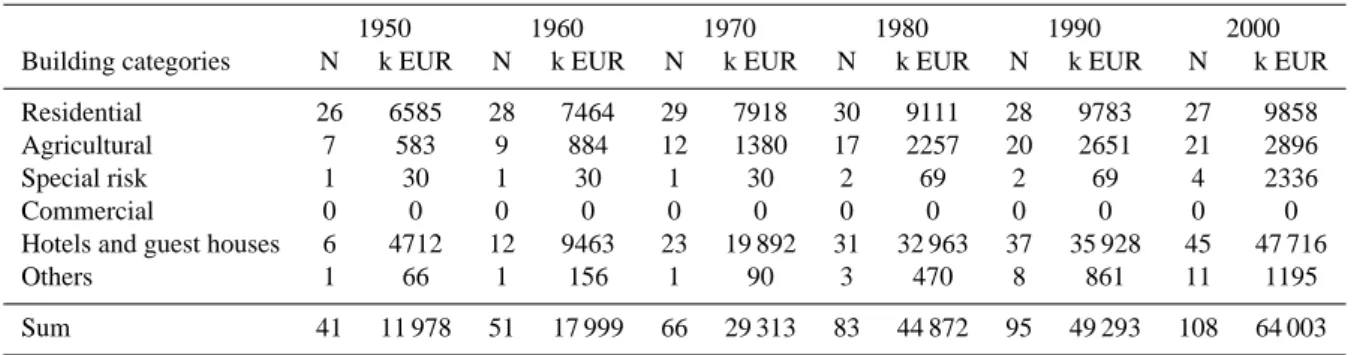
Others 1 66 1 156 1 90 3 470 8 861 11 1195
Sum 41 11 978 51 17 999 66 29 313 83 44 872 95 49 293 108 64 003
ings, 673 persons were concerned in 1950 and 1116 in 2000, which is an increase of two thirds. Subdividing the utilisa-tion within the winter season into months, it became evident that the peaks in utilisation were during the Christmas period and towards the end of February. According to the analy-sis of the avalanche bulletin of the Swiss Federal Institute of Snow and Avalanche Research SLF, these periods coin-cided exactly with periods when there was an above-average occurrence of days with high avalanche danger. As a result, temporal risk peaks may possibly arise, as described in Fuchs et al. (2004).
3.2 Values at risk in Galt¨ur
The values at risk were determined based on methods out-lined in Keiler (2004). The total number of buildings inside avalanche-prone areas in the municipality of Galt¨ur rose by a factor of 2.5 (Fig. 3, Table 4), from 41 in 1950 to 108 in 2000. This increase is due to the relative development in the category of hotels and guest houses, and – obviously less im-portant – in the category of agricultural buildings. The num-ber of buildings in all other categories stayed nearly constant. The decrease in the number of residential buildings since 1980 resulted from a modification of buildings formerly used for habitation to accommodation facilities subsequently used for tourism.
The total value of buildings rose by a factor of almost six. In 1950, the total value of buildings amounted to EUR 12 million and in 2000 to EUR 64 million. Since the 1960s, the category of hotels and guest houses held the highest pro-portion of the total amount of endangered values per decade and per category. In 1950, the proportion of hotels and guest houses was about 30%, compared to the total value of build-ings. In 2000, this ratio changed to approximately 75%. In contrast, the number and value of residential buildings showed nearly no change between 1950 and 2000. Gener-ally, the number of buildings in the community of Galt¨ur has risen above average in comparison to the district of Landeck and the federal state of Tyrol. In 2000, a quarter of the to-tal value of all buildings in the municipality was found to be located in the avalanche-prone areas. The proportional in-crease in the value of buildings was significantly higher than
the proportional increase in the number of buildings. Build-ings inside avalanche-prone areas showed a lower average value as buildings outside those areas. These findings were in accordance to similar results for the community of Davos. The number of endangered persons increased substan-tially. In Galt¨ur, in 1950, approximately 850 persons were located inside exposed areas, consisting of 460 residents and 390 tourists. Until the year 2000, this value increased to 4700 persons, 770 of which were residents and 3930 were tourists. The increase in residential population was about 60%, while the increase in temporal population was a factor of ten. Thus, considerable diurnal risk peaks might occur, as presented in Keiler et al. (2005).
4 Discussion
The results of an analysis of damage potential in Davos (CH) and Galt¨ur (A) suggested a similar trend, even if the com-munity of Galt¨ur and the comcom-munity of Davos have dif-ferent historical roots. Both municipalities have undergone significant socio-economic changes during the 20th century. While Davos was transformed into a winter sports destina-tion from a tradidestina-tional health resort, Galt¨ur developed from a farming village to a centre of sustainable winter tourism. Since 1950, a significant change in the number and value of buildings has taken place in both studied municipalities, and, as a consequence, a remarkable increase was detectable in residential and temporal population. Endangered areas were increasingly protected by technical mitigation mea-sures since the 1950s (Davos) and 1960s (Galt¨ur). Par-allel to those technical tools, spatial planning instruments were introduced. At the same time, governmental authorities in Switzerland (Frutiger, 1980) and in Austria (Bergthaler, 1975) were founded to organise protection against natural hazards.
In Davos, the increase in damage potential was caused by a significant increase in the category of residential buildings, while in Galt¨ur this increase could mainly be attributed to an increase in accommodation facilities. These results can be attributed to (1) the different socio-economic development of the municipalities and (2) the different legal situations in
900 S. Fuchs et al.: Temporal variability of damage potential in settlements Switzerland and Austria. While in Austria, the construction
of secondary residences was restricted by law until the late 1990s, no such restrictions could be found in the canton of Grisons, Switzerland. In both municipalities, the highest in-crease in number and value was spatially located at the outer boundary of the endangered areas. These findings are also represented by the high range shown in Fig. 2 for the mu-nicipality of Davos. Thus, relatively small variations in the lateral extent of the areas affected by avalanches have a high impact on the values at risk. For this reason, a possible im-provement in the delimitation of areas affected by natural hazard processes regarding a decrease of objects at risk could possibly be implemented using a fringe instead of a line.
Temporal changes in risk can primarily be attributed to the outlined spatiotemporal variations in damage potential. The analysis of tangible assets as well as intangibles is a quantitative procedure for comparative studies in different re-gions and for different hazard processes. Thus, risk analyses should consider those alternations by expanding the today’s procedures by appropriate methodical approaches as well as practical implementations.
The long-term trend in the development of damage poten-tial described above is superposed by a short-term fluctuation resulting from diurnal peaks in values at risk, particularly consisting of persons commuting to and from tourist destina-tions. The combination of those two phenomena should be carefully observed and integrated in the methodology of risk analyses, as shown by Keiler et al. (2005) for the commu-nity of Galt¨ur. Similar problems related to road networks are discussed in Margreth et al. (2003) and Zischg et al. (2005a, b). In dealing with natural hazards in a proactive manner, this aspect should be strengthened and incorporated into the respective legal fundamentals.
Land use planning activities such as hazard maps are based on the concept of recurrence intervals of hazard processes. The remarkable increase of values at risk in the fringe of the endangered areas would result in a significant shift in mon-etary losses (and presumably fatalities) if the design event is exceeded. Due to the damage in the avalanche winter 1999, the delimitation of endangered areas is based on mod-ified avalanche pressures in Austria. These modifications in principle represent a change of the considered design events. Similar developments might be discussed in the aftermath of the 2005 inundations in the Alps. Thus, future research is needed to quantify the impact of such modifications on (1) the result of risk analyses, (2) the assessment of risk in the cycle of integrated risk management, (3) the adjustment of coping strategies, and (4) the perception of risk by all parties involved, including policy makers.
Appendix
It is the responsibility of the Swiss cantons to protect people’s life and property from natural hazards such as avalanches, landslides, erosion and rockfall in accordance with the Fed-eral Law of 22 June 1979 relating to land-use planning.
Fur-ther implementation instructions result from the appropriate articles in the Federal Law of 4 October 1991 relating to forests and the Federal Law of 21 June 1991 relating to hy-draulic engineering. According to these laws and associated decrees, the appropriate specialised offices of the federal au-thorities have to compile guidelines to encourage the consid-eration of natural hazards in land-use planning. The princi-ples for general planning issues are published in Heinimann et al. (1998), whereas the Guidelines for the Consideration of
the Avalanche Danger in Land-Use Planning Activities have
been approved in 1984 (BFF and SLF, 1984). These guide-lines describe the two main instruments for the inclusion of avalanche danger in land-use planning, namely avalanche in-cident documentation and the avalanche hazard map. This hazard map divides an examined area into different subsec-tions with different danger levels according to the severity and the likelihood of potential avalanche hazards (BFF and SLF, 1984).
Red indicates areas where pressure from avalanches with recurrence intervals T between 30 and 300 years exceeds a lower limit that ranges from 3 kPa for T =30 years to 30 kPa at T =300 years. The entire area affected by (dense flow) avalanches with T <30 years is also marked in red.
Blue indicates areas where pressure from avalanches with recurrence intervals T between 30 and 300 years falls below 30 kPa. Areas affected by powder avalanches with reoccur-rence intervals T <30 years and a pressure <3 kPa are also marked in blue.
The run-out areas of powder avalanches with reoccurrence intervals T >30 years and a pressure <3 kPa are marked in yellow, as well as theoretically not excludable but extremely rare avalanches with a reoccurrence interval T >300 years.
Acknowledgements. For valuable discussion, continuing support
and the supply of data, the authors want to thank M. Fischer, GVA building insurance Grisons (CH), K. Walser and the community of Galt¨ur (A), and C. Wilhelm, Forestry Office of Grisons (CH). The study related to the development of avalanche risk in Davos was financed by WSL Swiss Federal Institute for Snow and Avalanche Research SLF. The studies were supported by grants offered by MunichRe Reinsurance Company.
Edited by: H. St¨otter Reviewed by: one referee
References
Ammann, W.: Integrales Risikomanagement – der gemeinsame Weg in die Zukunft, B¨undnerwald, 5, 14–17, 2001.
Barbolini, M., Natale, L., and Savi, F.: Effects on release conditions uncertainty on avalanche hazard mapping, Nat. Haz., 25, 225– 244, 2002.
Benson, C., and Clay, E.: Understanding the economic and financial impacts of natural disasters, Washington, The World Bank, 2004.
Bergthaler, J: Grunds¨atze zur Erarbeitung von
Gefahrenzo-nenpl¨anen in Wildb¨achen der N¨ordlichen Kalkalpen und der Grauwackenzone, ¨Osterr. Wasserwirtschaft, 27, 160–168, 1975. BFF and SLF: Richtlinien zur Ber¨ucksichtigung der Lawinengefahr
Forstwesen, Eidgen¨ossisches Institut f¨ur Schnee- und Lawinen-forschung, 1984.
BfS (ed.): Statistisches Jahrbuch der Schweiz 2001, Z¨urich, Verlag NZZ, 2001.
BfS (ed.): Krankenhausstatistik, http://www.bfs.admin.ch/content/ bfs/portal/de/index/themen/gesundheit/gesundheitsversorgung/ einrichtungen/analysen berichte/stand/01.html, (access 20 July 2005), 2002.
Bj¨ornsson, H.: Avalanche activity in Iceland, climatic conditions, and terrain features, J. Glaciol., 26, 13–23, 1980.
Christen, M., Bartelt, P. and Gruber, U.: AVAL-1D: An avalanche dynamics program for the practice, Proceedings Interpraevent 2002 in the Pacific Rim – Matsumoto, 14–18 October 2002, 2, 715–725, 2002a.
Christen, M., Bartelt, P. and Gruber, U.: AVAL-1D, Numerische Berechnung von Fliess- und Staublawinen, Manual zur Software, Eidgen¨ossisches Institut f¨ur Schnee- und Lawinenforschung, Davos, 2002b.
Dilley, M., Chen, R., Deichmann, U., Lerner-Lam, A., and Arnold, M.: Natural disasters hotspots, a global risk analysis, Washing-ton, The World Bank, 2005.
Frutiger, H.: Rechtliche Aspekte der Nutzungsbeschr¨ankung
des Grundeigentums wegen Lawinengef¨ahrdung, Proc. Inter-nationales Sympos. Interpraevent – Bad Ischl, Austria, 8–12 September 1980, 1, 33–48, 1980.
Fuchs, S., Br¨undl, M., and St¨otter, J.: Development of avalanche risk between 1950 and 2000 in the municipality of Davos, Switzerland, Nat. Hazards Earth Syst. Sci., 4, 263–275, 2004,
SRef-ID: 1684-9981/nhess/2004-4-263.
Fuchs, S., and Br¨undl, M.: Damage potential and losses resulting from snow avalanches in settlements in the Canton of Grisons, Switzerland, Nat. Haz., 34, 53–69, 2005.
Gemeinde Galt¨ur: Bettenauslastung, http://www.galtuer.gv.at/
betten.htm (access July 20, 2005), 2003.
Glade, T., and Crozier, M.: Towards a national landslide informa-tion base for New Zealand, New Zealand Geographer, 52, 29–40, 1996.
Heinimann, H., Hollenstein, K., Kienholz, H., Krummenacher, B., and Mani, P.: Methoden zur Analyse und Bewertung von Naturgefahren, Bern, BUWAL, 1998.
IUGS: Quantitative risk assessment for slopes and landslides – the state of the art, in: Landslide Risk Assessment, edited by: Cruden, D. and Fell, R., Proc. of the International Workshop on Landslide Risk Assessment – Honolulu, Hawaii, USA, 19–21 February 1997, Rotterdam, 3–12, 1997.
J´ohannesson, T. and Arnalds, T.: Accidents and economic damage due to snow avalanches and landslides in Iceland, J¨okull, 50, 81– 94, 2001.
J´onasson, K., Sigurdsson, S., and Arnalds, T.: Estimation of avalanche risk, Icelandic Meteorological Office, Reykjavik, V´I-R99001- ´UR01, 1999.
Keiler, M.: Development of the damage potential resulting from avalanche risk in the period 1950–2000, case study Galt¨ur, Nat. Hazards Earth Syst. Sci., 4, 249–256, 2004,
SRef-ID: 1684-9981/nhess/2004-4-249.
Keiler, M., Zischg, A., Fuchs, S., Hama, M., and St¨otter, J.: Avalanche related damage potential – changes of persons and mobile values since the mid-twentieth century, case study Galt¨ur, Nat. Hazards Earth Syst. Sci., 5, 49–58, 2005,
SRef-ID: 1684-9981/nhess/2005-5-49.
Keylock, C, and Barbolini, M.: Snow avalanche impact pressure – vulnerability relations for use in risk assessment, Can. Geotech. J., 38, 227–238, 2001.
Kleist, L., Thieken, A., K¨ohler, P., M¨uller, M., Seifert, I., and Werner, U.: Estimation of building values as a basis for a com-parative risk assessment, in: Disasters and society, edited by: Mahlzahn, D. and Plapp, T., Berlin, logos, 115–122, 2004. Kurverein Davos: Gesch¨aftsbericht 1950/1951, Davos, Kurverein,
1951.
Landesstatistik Tirol: Tourismus, http://www.tirol.gv.at/themen/ zahlenundfakten/statistik/tourismus.shtml (access 20 July 2005), 2003.
Landesstatistik Tirol: Landesstatistik Tirol, http://www.tirol.gv.at/ themen/zahlenundfakten/statistik/wohnbevoelkerung.shtml (ac-cess 20 July 2005), 2004.
Laternser, M. and Schneebeli, M.: Temporal trend and spatial dis-tribution of avalanche activity during the last 50 years in Switzer-land, Nat. Haz., 27, 201–230, 2002.
Margreth, S., Stoffel, L., and Wilhelm, C.: Winter opening of high alpine pass roads – analysis and case studies from the Swiss Alps, Cold Reg. Sc. Tech., 37, 467–482, 2003.
Merz, B., Kreibich, H. Thieken, A., and Schmidtke, R.: Estimation uncertainty of direct monetary flood damage to buildings, Nat. Hazards Earth Syst. Sci., 4, 153–163, 2004,
SRef-ID: 1684-9981/nhess/2004-4-153.
MunichRe: Wetterkatastrophen und Klimawandel: Sind wir noch zu retten?, M¨unchen, Munich Reinsurance Company, 2005a. MunichRe: Topics Geo – annual review: natural catastrophes 2004,
M¨unchen, Munich Reinsurance Company, 2005b.
Norem, H.: Shear stresses and boundary layers in snow avalanches, NGI Technical Report 581240-3, Oslo, Norwegian Geotechnical Institute, 1995.
Ritzmann-Blickenstorfer, H.: Historische Statistik der Schweiz, Z¨urich, Chronos, 1996.
Stethem, C., Jamieson, B., Schaerer, P., Liverman, D., Germain, D., and Walker, S.: Snow avalanche hazard in Canada – a review, Nat. Haz., 28, 487–515, 2003.
United Nations: Living with risk, Geneva, United Nations, 2004. Wilhelm, C.: Wirtschaftlichkeit im Lawinenschutz, edited by SLF
Eidgen¨ossisches Institut f¨ur Schnee- und Lawinenforschung, Mtt. 54, Davos, 1997.
Zischg, A., Fuchs, S., Keiler, M., and Meißl G.: Modelling the system behaviour of wet snow avalanches using an expert system approach for risk management on high alpine traffic roads, Nat. Hazards Earth Syst. Sci., 5, 821–832, 2005a,
SRef-ID: 1684-9981/nhess/2005-5-821.
Zischg, A., Fuchs, S., Keiler, M., and St¨otter, J.: Temporal variabil-ity of damage potential on roads as a conceptual contribution to-wards a short-term avalanche risk simulation, Nat. Hazards Earth Syst. Sci., 5, 235–242, 2005b,