HAL Id: hal-00299303
https://hal.archives-ouvertes.fr/hal-00299303
Submitted on 31 Oct 2005
HAL is a multi-disciplinary open access
archive for the deposit and dissemination of
sci-entific research documents, whether they are
pub-lished or not. The documents may come from
teaching and research institutions in France or
abroad, or from public or private research centers.
L’archive ouverte pluridisciplinaire HAL, est
destinée au dépôt et à la diffusion de documents
scientifiques de niveau recherche, publiés ou non,
émanant des établissements d’enseignement et de
recherche français ou étrangers, des laboratoires
publics ou privés.
using an expert system approach for risk management
on high alpine traffic roads
A. Zischg, S. Fuchs, M. Keiler, G. Meißl
To cite this version:
A. Zischg, S. Fuchs, M. Keiler, G. Meißl. Modelling the system behaviour of wet snow avalanches
using an expert system approach for risk management on high alpine traffic roads. Natural Hazards
and Earth System Science, Copernicus Publications on behalf of the European Geosciences Union,
2005, 5 (6), pp.821-832. �hal-00299303�
Natural Hazards and Earth System Sciences, 5, 821–832, 2005 SRef-ID: 1684-9981/nhess/2005-5-821
European Geosciences Union
© 2005 Author(s). This work is licensed under a Creative Commons License.
Natural Hazards
and Earth
System Sciences
Modelling the system behaviour of wet snow avalanches using an
expert system approach for risk management on high alpine traffic
roads
A. Zischg1, S. Fuchs2, M. Keiler3, and G. Meißl4
1Geo Information Management, Gargazzone, Italy
2alpS Centre for Natural Hazard Management, Innsbruck, Austria
3Department of Geography and Regional Research, University of Vienna, Austria 4Institute of Geography, University of Innsbruck, Austria
Received: 15 July 2005 – Revised: 12 October 2005 – Accepted: 12 October 2005 – Published: 31 October 2005 Part of Special Issue “Spatial prediction modeling in natural hazards and risk”
Abstract. The presented approach describes a model for a rule-based expert system calculating the temporal variabil-ity of the release of wet snow avalanches, using the assump-tion of avalanche triggering without the loading of new snow. The knowledge base of the model is created by using inves-tigations on the system behaviour of wet snow avalanches in the Italian Ortles Alps, and is represented by a fuzzy logic rule-base. Input parameters of the expert system are numeri-cal and linguistic variables, measurable meteorologinumeri-cal and topographical factors and observable characteristics of the snow cover. Output of the inference method is the quanti-fied release disposition for wet snow avalanches. Combining topographical parameters and the spatial interpolation of the calculated release disposition a hazard index map is dynam-ically generated. Furthermore, the spatial and temporal vari-ability of damage potential on roads exposed to wet snow avalanches can be quantified, expressed by the number of persons at risk. The application of the rule base to the avail-able data in the study area generated plausible results. The study demonstrates the potential for the application of expert systems and fuzzy logic in the field of natural hazard moni-toring and risk management.
1 Introduction
Snow avalanches pose a threat to settlements, infrastructure and road networks in alpine environments. In contrast to dry snow and powder avalanches, the movement of wet snow avalanches is characterised by lower velocities combined with high friction coefficients. Thus, wet snow avalanches do not threat significantly settlements or infrastructures lo-cated in the valleys but traffic axes in the alpine
environ-Correspondence to: A. Zischg
ments, often following the contour lines of hill slopes or crossing avalanche paths in their transition zones. Therefore, avalanches of this type pose a significant threat to road users. To reduce this susceptibility of roads to avalanche hazards, a considerable amount of money has been spent by the public sector to realise technical mitigation measures. As a result, part of the alpine road network is protected by avalanche gal-leries or has to be permanently or temporarily closed during the winter months, although the road network is endangered only a few days every year. Additionally, limited financial resources of the public sector and the increasing significance of the road network for the local economic activities, an effi-cient and sustainable policy of public expenditures for pro-tection against natural hazards is needed (Wilhelm, 1997; Margreth et al., 2003). The construction of permanent mit-igation measures for the road network would produce very high costs. Consequently, an improvement of organisational measures, lead by an enhancement of early warning and de-cision support systems (Kienholz, 2003; UN/ISDR, 2004; Br¨undl et al., 2004), is necessary. Organisational measures like temporary road closures require a well-informed deci-sion maker with profound knowledge of the observed envi-ronmental system, the related indicators of critical situations, the related risks and the criteria for raising alarms (Kienholz, 2003). Additionally, during moderate avalanche hazard lev-els considerable risk peaks occur due to a high traffic density, as pointed out by Zischg et al. (2005). Following the sugges-tions of that study, the decision process in operational risk management on roads can be enhanced taking into considera-tion the temporal variability of both, the avalanche hazard po-tential and the damage popo-tential by computing the avalanche risk in a short-term timeframe.
The aim of this study was to develop an expert system for modelling the system behaviour of wet snow avalanches and determining the number of potentially affected persons on
roads, based on the observation of the environmental condi-tions and the traffic density.
Apart from expert systems, either information systems or decision support systems could be used to enhance ex-perts’ and decision makers’ knowledge for road risk man-agement (Sailer, 2001; Kienholz, 2003; Br¨undl et al., 2004). While information systems provide raw data and informa-tion, decision support systems provide purpose-built and prepared information (Mittra, 1986; Sprague and Watson, 1986). Whereas both system architectures provide different types of information about the system behaviour, they do not provide decisions. In contrast, expert systems simulate hu-man reasoning about a problem domain, rather than simulat-ing the domain itself (Jackson, 1999). Expert systems per-form reasoning over representation of human knowledge by heuristic or approximate methods. In this way, the computer programs are designed by crystallising the expert’s problem-solving logic in a knowledge base that non-expert users or experts in other disciplines can then apply to similar prob-lems with data related to those probprob-lems and their context (Rodriguez-Bachiller and Glasson, 2004). As synonym for the term “expert system”, the term “knowledge-based sys-tem” sometimes is used, although the latter is more general and usually do not include algorithmic or statistical meth-ods (Jackson, 1999). Fundamental topics in expert systems are the transfer and the transformation of potential problem-solving expertise from some knowledge source to a program, the representation of knowledge, the modelling of the reason-ing process, and the explanation of the computed solutions (Jackson, 1999). These topics determine the structure and the design of expert systems. The knowledge base is repre-sented in the form of if-then rules. By a user interface or di-rect connections with measurement instruments, the needed data about the observed system can be inserted into an imple-mented database. Based on this input data, the rule base is queried by the inference engine. The inference engine iden-tifies which rules provide values for the current environmen-tal conditions and computes the final conclusion of all rules (Rodriguez-Bachiller and Glasson, 2004).
One characteristic of expert systems is the explanation of the computed results of the inference procedure. It is the capacity of explaining why and how a particular conclu-sion is computed, simply detailing for the user the chain of conditions and the fulfilment of the applied rules. Another characteristic of expert systems is the separation between the knowledge involved in problem-solving and the knowl-edge involved in designing the inference engine (Rodriguez-Bachiller and Glasson, 2004). This separation leads to the possibility of amplification and enhancement of the rule base by the expert, independent from the version of the software. Therefore, the technique for transformation of the expert’s knowledge into a rule base and the amplification of the rule base by the user, the so called “knowledge acquisition” or “knowledge engineering” becomes the fundamental step in building expert systems.
In the past decades, several expert systems for the appli-cation in avalanche forecasting and in operational risk
man-agement were developed. Bolognesi (1993) and Bolognesi et al. (1994) presented an expert system for the avalanche forecasting on a local scale (AVALOG), Schweizer and F¨ohn (1996), Schweizer et al. (1994) and Brabec (2001) showed an approach for the avalanche forecasting on a regional scale (DAVOS, MODUL, NXD-REG). An expert system for the determination of avalanche release zones on the basis of dig-ital terrain models was pointed out by Buisson and Charlier (1989). Buisson and Charlier (1993) showed an approach for the analysis of the characteristics of avalanche paths (ELSA). An approach for the forecasting of the avalanche triggering probability (SAFRAN-CROCUS-MEPRA) was demonstrated by Buisson and Giraud (1995) and Durand et al. (1999). Kleemayr et al. (2000) developed a numerical avalanche prediction model (NAFT) based on the combina-tion of statistical analysis, artificial neural networks and a fuzzy-expert system. McClung (1995a, b) developed an ex-pert system for the interpretation of snow profiles.
These approaches focused on the estimation of the avalanche hazard potential, particularly with respect to the triggering of dry snow slab avalanches. None of the cited studies focused either on the triggering probability of wet snow avalanches or on the related damage potential. Fur-thermore, the uncertainties in the computing process mostly are not taken into account. The study presented in this pa-per focussed on the determination and representation of the temporal variability of both risk factors, the hazard potential and the damage potential. In this work, the expected fatal-ities on roads due to wet snow avalanches were calculated based on the current environmental conditions (snow cover characteristics, snow and air temperature). The system be-haviour of wet snow avalanches was modelled on the basis of the available data and the existing knowledge about this pro-cess. The uncertainties in the used modelling approach for the representation of the system behaviour were taken into consideration. The short-term variability analysis of the be-haviour of the system “avalanche prone road” – expressed by the time-variable “avalanche related damage potential on roads” – requires the observation of the diurnal variability of the hazard potential and the damage potential.
The highly variable hazard potential of avalanches consists of three different phases characterised by the process (Zim-mermann et al., 1997). The phase “basic disposition” is the general long-term tendency or readiness for the geomorpho-logic process due to topography, vegetation and climate of the site. These conditions are considered as constant in the short-term timeframe (day). The phase “variable disposition” is the temporally alternating disposition for dangerous pro-cesses resulting from the seasonal and diurnal variability of meteorological parameters. The phase “variable disposition” varies within a timeframe of days or hours. The “triggering event” finally forms the strain to the system with a basic and high variable disposition for dangerous processes and might cause a release of the process. This process phase varies within a timeframe of a few hours or seconds. In forecast-ing dangerous processes, the consideration of these differ-ent process phases is important, because their indicators and
A. Zischg et al.: Monitoring of wet snow avalanche risk on roads 823
parameters depend on the time delay before the triggering of the process. If the reaction time needed for the evacuation of endangered areas is half a day, the triggering event can not be considered because the environmental conditions related to this process phase change faster than the needed time for evacuation of potentially endangered areas. Thus, forecast-ing e.g. the release of wet snow avalanches one day before a triggering event, the daily variable release disposition has to be modelled. Because of rapidly changing environmental conditions related to the triggering event (hours or seconds), this process phase can not be considered in the considered timeframe (one day). In this study, it was aimed to model the daily variability of the process phase “variable disposi-tion” for the release of wet snow avalanches as the basis of the estimation of the hazard potential.
The damage potential on road networks is defined by the number of potentially endangered persons and is subse-quently derived from the traffic density, as outlined in Wil-helm (1997) and Borter (1999). The daily traffic density, and, as a consequence, the variable damage potential, is subject to considerable variations, particularly in regions affected by tourism. The method for analysing risk in a short-term time-frame, as outlined in Zischg et al. (2005), had to be adapted to the process characteristics of wet snow avalanches.
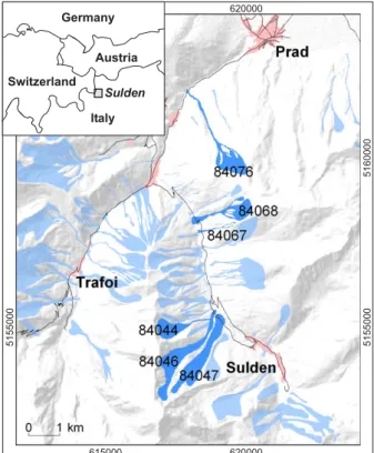
The method was developed and tested in the avalanche-prone study area of the Sulden road between the munic-ipalities of Prad and Sulden, Sulden Valley, Autonomous Province of Bozen, Italy (Fig. 1). This road serves as access road to the main ski area of the region and is therefore of par-ticular importance for winter tourism. The road segment is 20 km long and is endangered by 22 avalanche paths which reached the road at least once during the 25 years of obser-vation by the avalanche incident registry of the Autonomous Province of Bozen-South Tyrol. Due to the construction of permanent protection measures during the 1970s and 1980s, 17 avalanches in twelve paths remained perilous and threat-ened the road in 2004 (Fig. 1).
2 Method
The procedure of modelling the behaviour of the system “wet snow avalanche prone road” is based on three modules: The first module computes the variable disposition for the release of wet snow avalanches. The second component of the pro-cedure selects the avalanche paths that pose a potential haz-ard to the road under current environmental conditions and deduces an avalanche hazard index map. Based on this dy-namically created hazard index map, the third module cal-culates the number of potentially affected persons on the road. A user interface facilitates the management of data in-put, the amplification of the rule base, the inference method and shows the results in the form of alphanumerical data and maps. The required methodological procedures used in this study are described in the following sections.
24 Figure 1: Study area Sulden Road, Ortles Alps, South Tyrol, Italy. In slight blue, the dataset of the avalanche observation database of the Autonomous Province of Bolzano – South Tyrol is illustrated. In deep blue, the avalanches are pointed out that in the observation period (1980-2000) reached once the Sulden road as wet snow avalanche. The labels indicate the official ID of the avalanche database. Source: Autonome Provinz Bozen-Südtirol/Lawinenwarndienst (2003). Coordinate system: UTM N32 ETRS89.
620000 5155000 5160000 5155000 615000 620000 Italy Switzerland Germany Sulden Austria
Fig. 1. Study area Sulden Road, Ortles Alps, South Tyrol, Italy. In slight blue, the dataset of the avalanche observation database of the Autonomous Province of Bolzano – South Tyrol is illustrated. In deep blue, the avalanches are pointed out that in the observation period (1980–2000) reached once the Sulden road as wet snow avalanche. The labels indicate the official ID of the avalanche database. Source: Autonome Provinz Bozen-S¨udtirol/Lawinenwarndienst (2003). Coordinate system: UTM N32 ETRS89.
2.1 Modelling the variable disposition for the release of wet snow avalanches
The release probability of dry snow avalanches in the long-term timeframe (for example in 30 years), is deduced from the recurrence interval of a certain amount of new snow in three days within the considered timeframe. It is assumed that the occurrence probability of the avalanche event equals the occurrence probability of the snowfall event (Wilhelm, 1997). This approach has been adapted for the determination of the avalanche release probability in the short-term time-frame by Zischg et al. (2005). In this approach, the avalanche occurrence probability in the short-term timeframe is deter-mined on the basis of a statistical correlation to the fresh snow accumulation in three days. This simplified method is not adaptable for the purpose of modeling the release probability of wet snow avalanches, because there is not a single significant parameter for the triggering of wet snow avalanches such as it is the strain of a new snow layer to the older snow pack (McClung and Schaerer, 1993). The vari-able release disposition of wet snow avalanches depends on
a combination of interdependent environmental parameters. Besides the loading by new precipitation (snow or rain), wet snow avalanches can be triggered by changes in strength of a buried weak layer due to water, or by water lubrication of a sliding surface (McClung and Schaerer, 1993). The moisture penetration in a snow pack may be a result of snow melting due to solar radiation, due to latent heat transfer or a rainfall event. The increase of moisture in the snow pack results in a decline of the stability caused by a decrease of friction and cohesion. Frequently, wet slab avalanche events occur dur-ing rainfall periods in wintertime or durdur-ing the first period of snow melting in spring (LaChapelle, 1977). One indicator for a high disposition for wet snow avalanches is an isother-mal snow pack on southern exposed hill slopes (Armstrong and Yves, 1976). After the snow pack is becoming isother-mal, the content of free water in the snow cover increases during the following days while the strength of the snow cover decreases. Isothermal conditions can be observed 10– 15 days prior the first significant wet snow avalanche activity in spring (Armstrong and Yves, 1976). The decreasing cohe-siveness is reflected by decreasing ram hardness. After a pe-riod of isothermal conditions, during days with a mean daily air temperature above 0◦C an increased wet slab avalanche activity can be observed. On the basis of these indicators, days with an increased avalanche activity could be predicted. But the exact point in time, when an avalanche is triggered, can not be predicted on a regional level, due to the complex interaction between topographical, meteorological and nivo-logical parameters (Armstrong and Yves, 1976).
The aim of this procedure was to model the variable dis-position for wet snow avalanches during the winter on a re-gional scale. The procedure was developed based on the ex-ample of the Sulden road, but the spatial resolution of the release disposition is defined by the regional scale. In this paper, the term “wet snow avalanche” was used for wet slab avalanches, which are not triggered by the loading of new snow. Loose snow avalanches were not considered. The con-ditions leading to the triggering of large wet snow avalanches capable of reaching the road have been evaluated on the basis of measurements or observations of different environmen-tal parameters. The limits of the determination of the wet snow avalanche release probability on the basis of a statisti-cal correlation become clearly obvious due to the insufficient statistical basis. Moreover the computation method of the daily release probability is subject to significant uncertainties (Zischg et al., 2005). A possibility for the simulation of the varying release disposition of an avalanche is the fuzzy logic approach. This allows statistically non-significant parame-ters as well as the preconditions of the system to be taken into consideration. Furthermore, quantitative and qualitative vari-ables can be combined mathematically and the uncertainties in the data basis can be dealt with. While dealing with natu-ral hazards, however, uncertainty is part of most approaches (Barbolini et al., 2002; Bell and Glade, 2004: Zischg et al., 2004).
Uncertainty can be classified into three main types (Zim-mermann, 1993): First, uncertainty is based on the lack of
knowledge of the future state of a system. This type of uncer-tainty is subject to randomness (stochastic unceruncer-tainty). Sec-ond, uncertainty arises due the lack of information about the system behaviour (vagueness, ambiguity, fuzziness). Third, uncertainty is based on inexactness of measurements (impre-ciseness, fuzziness). Probability theory provides methods to compute the first nature of uncertainty related to random-ness, while fuzzy logic provides mathematical methods to compute the second group of uncertainty (impreciseness). In comparison to the results of stochastic events, which can ei-ther be true or false; results of fuzzy events can be quantified by a degree of truth or a membership to a set (Zadeh, 1965). Fuzzy logic is a way of combining quantitative and qualita-tive variables, which belong to a specific fuzzy set (Zadeh, 1975). Elements can be a partially member of a specific set and at the same time have a partially membership of the com-plement set (Zadeh, 1965). This kind of element representa-tion leads to a possibility for dealing with vague informarepresenta-tion and imprecise input data. Integrated into an expert system, fuzzy logic provides an opportunity for the representation of imprecise and linguistic variables in the computing proce-dure and the representation of the expert knowledge within a fuzzy logic rule base.
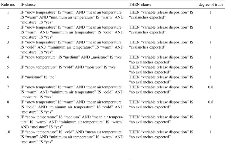
The knowledge base in this procedure is based on the supra-regional expert knowledge accessible by the scientific literature and the knowledge about the specific regional prop-erties of the system behaviour. The scientific background, summarized in the former section, is incorporated in a sim-plified way into the rule base as shown in Table 1. Only vari-ables for which a continuous dataset exists are represented in the rule base.
The supra-regional expert knowledge was adapted to the specific conditions and the available dataset describing the daily variability of the system behaviour. For the implemen-tation of the adapted knowledge into the fuzzy logic rule base, observation data from the snow measurement station in Weissbrunn (1900 m a.s.l.), 20 km south-east of the study area, was used. Since December 1983, snow heights, the amount of new snow, the snow and air temperature, and the density of the snow pack according to the guidelines of the Interregional Association for Snow and Avalanches in Italy AINEVA were measured at this station (Autonome Provinz Bozen-S¨udtirol/Lawinenwarndienst 1983, 1997). The envi-ronmental parameters recorded from 1983 to 2000 were com-pared with the observed and documented avalanche events in the study area. For those avalanches that hit the road section, the temperature of the snow cover in a depth of 30 cm, the amount of precipitation (rain), the mean daily air temperature, the daily minimum of the air temperature, and the moisture in the snow cover, were analysed and classi-fied into fuzzy sets. For every fuzzy set, the membership functions were determined on the basis of statistical analy-ses of a sample of the dataset (Zischg, 2004). The mem-bership functions of the variables taken into consideration in the computing process are illustrated in Fig. 2. The mois-ture of the snow pack and the output variable “wet snow avalanche release disposition” were considered as linguistic
A. Zischg et al.: Monitoring of wet snow avalanche risk on roads 825
Table 1. Rule base of the expert system.
Rule no. IF-clause THEN-clause degree of truth
1 IF “snow temperature” IS “warm” AND “mean air temperature” IS “warm” AND “minimum air temperature” IS “warm” AND “moisture” IS “yes”
THEN “variable release disposition” IS “avalanches expected”
1
2 IF “snow temperature” IS “warm” AND “mean air temperature” IS “warm” AND “minimum air temperature” IS “cold” AND “moisture” IS “yes”
THEN “variable release disposition” IS “avalanches expected”
1
3 IF “snow temperature” IS “warm” AND “mean air temperature” IS “cold” AND “minimum air temperature” IS “warm” AND “moisture” IS “yes”
THEN “variable release disposition” IS “avalanches expected”
1
4 IF “snow temperature” IS “medium” AND ,,moisture” IS “yes” THEN “variable release disposition” IS “no avalanches expected”
1 5 IF “snow temperature” IS “cold” AND “moisture” IS “yes” THEN “variable release disposition” IS
“no avalanches expected”
1 6 IF “moisture” IS “no” THEN “variable release disposition” IS
“no avalanches expected”
1 7 IF “snow temperature” IS “warm” AND “mean air temperature”
IS “warm” AND “minimum air temperature” IS “cold” AND ,,moisture” IS “yes”
THEN “variable release disposition” IS “no avalanches expected”
0.8
8 IF “snow temperature” IS “warm” AND “mean air temperature” IS “cold” AND “minimum air temperature” IS “cold” AND “moisture” IS “yes”
THEN “variable release disposition” IS “no avalanches expected”
0.8
9 IF “snow temperature” IS “medium” AND “mean air tempera-ture” IS “warm” AND “minimum air temperatempera-ture” IS “warm” AND “moisture” IS “yes”
THEN “variable release disposition” IS “no avalanches expected”
1
10 IF “snow temperature” IS “cold” AND “mean air temperature” IS “warm” AND “minimum air temperature” IS “warm” AND “moisture” IS “yes”
THEN “variable release disposition” IS “no avalanches expected”
1
25 Figure 2: Implemented membership functions of the environmental parameters.
1
0 µ(x)
mean air temperature [°C] 6 4 2 0 -2 -4 -6 -8 1 0 snow temperature [°C] 0 -1 -2 -3 -4 -5 -6 -7
cold medium warm
µ(x)
cold warm
Fig. 2. Implemented membership functions of the environmental parameters.
variables after Zadeh (1975) and described by a singleton. After Cox (1999), the rules were weighted according to their importance by means of a degree of confidence into the rule within the range (0...1). This degree of confidence into the rule forms the maximally possible degree of applicability of a rule to a specific environmental condition. The quantita-tive variables of the input data had been fuzzyfied by means of the membership functions shown in Fig. 2. Qualitative variables were directly entered into the system as linguis-tic variables. The inference procedure computed the input data forward-chained, applying the rules of the knowledge base to this data. To the given specifications, the inference
engine looks for rules, which are suitable and applicable to the situation described by the input data. One inference step consists in the evaluation of a rule. Each condition in the IF-clause of a rule must be aggregated to the degree of appli-cability of the whole IF-clause (Zimmermann, 1993). In the aggregation step of the inference procedure the logical AND-operator was applied. This AND-operator determines the minimum of the fuzzy membership degrees of all variables in the IF-clause by using the minimum function. In the implication step of the inference procedure the MIN-operator was used. In this step, the membership degree of the output variable de-scribing the conclusion of a rule was computed on the basis
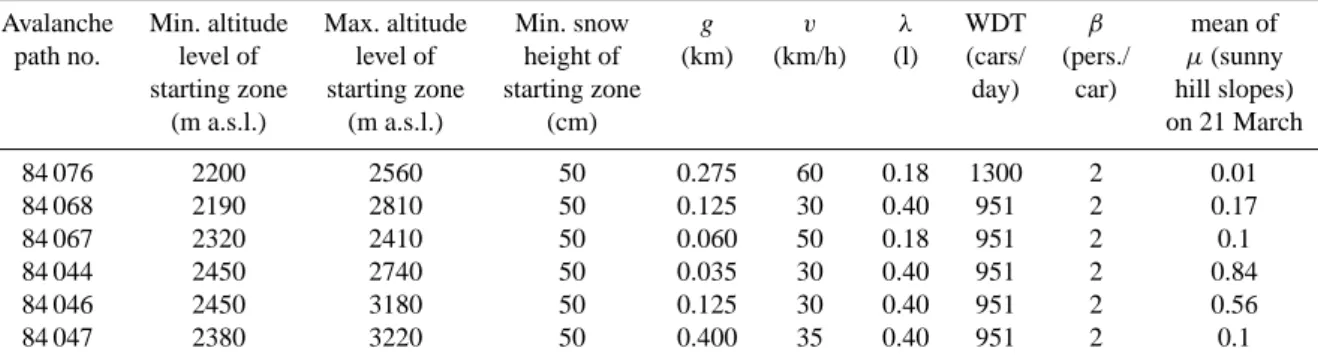
Table 2. Subset of wet snow avalanche paths that reached the road once during the observation period (1980–2000) and related topographic parameters of their starting zones. Additonally, an overview of the parameters used in the set of calculations of the number of potentially affected persons by avalanches on the road is given (cf. Zischg et al., 2005).
Avalanche Min. altitude Max. altitude Min. snow g v λ WDT β mean of path no. level of level of height of (km) (km/h) (l) (cars/ (pers./ µ(sunny starting zone starting zone starting zone day) car) hill slopes)
(m a.s.l.) (m a.s.l.) (cm) on 21 March
84 076 2200 2560 50 0.275 60 0.18 1300 2 0.01 84 068 2190 2810 50 0.125 30 0.40 951 2 0.17 84 067 2320 2410 50 0.060 50 0.18 951 2 0.1 84 044 2450 2740 50 0.035 30 0.40 951 2 0.84 84 046 2450 3180 50 0.125 30 0.40 951 2 0.56 84 047 2380 3220 50 0.400 35 0.40 951 2 0.1 26 Figure 3: Fuzzy membership function for the terms of the variable ‘exposition to the sun’.
1 0 µ(x) pixel value 200 150 100 50
shady hill slope sunny hill slope
Fig. 3. Fuzzy membership function for the terms of the variable “exposition to the sun”.
of the degree of applicability of the IF-clause (Bothe, 1993). The upper limit of the membership degree of the conclusion term of the rule was given by the degree of confidence into the rule. If more rules with the same conclusion term were existent, the membership degrees of the conclusion terms of all applicable rules had been accumulated to one member-ship degree of the final conclusion (Zimmermann, 1993). The implemented operator for the accumulation procedure of the inference engine was the maximum operator. The re-sult of the inference procedure was the accumulated mem-bership degree to each conclusion term of the variable “wet snow avalanche release disposition” in the rule base. For the rule base exemplarily illustrated in Table 1, the result was the membership degree of the conclusion terms “avalanches ex-pected” or “no avalanches exex-pected”. This value represents the membership of a specific day characterised by the related combination of environmental parameters to the fuzzy sets “days with expected wet snow avalanche activity” or “days with no avalanche activity expected”. The membership de-gree of the fuzzy set “days with expected wet snow avalanche activity” can be equated to a degree of compatibility to the concept “wet snow avalanche release disposition”.
2.2 Spatial interpolation of the release disposition for wet snow avalanches
In the second module of the procedure, avalanche paths that pose a potential hazard to the road under current environmen-tal conditions were determined. First, the avalanche observa-tion database was analysed and from all avalanche paths a subset of relevant avalanches was created. Those avalanches that reached the road as wet snow avalanche once during the observation period (1980–2000) were selected. Further-more, the topographic parameters of the starting zone of these avalanche paths were determined (see Table 2).
Second, from this subset those days with avalanches that feature a high release disposition were determined. In this step, the result of the modelled disposition for the release of wet snow avalanches was spatially interpolated. In combina-tion with the modelled release disposicombina-tion, addicombina-tional infor-mation in the avalanche bulletin describing the spatial char-acteristics of possible hazardous processes was used to de-termine avalanche paths for the road. During potentially hazardous situations, the avalanche bulletin gives informa-tion about the following topographical factors: The infor-mation about the spatial distribution of the height and the extent of the snow cover is differentiated by altitude and ex-position. Information about the moisture penetration of the snow cover is distinguished between altitude levels and ex-position classes (sunny or shady hillside situations). These topographic parameters were spatially interpolated based on GIS-operations. The parameter “exposition of the hill slope to the sun” was classified into two terms, either expressed as “sunny” or “shady hill slopes”. The hillshade-function implemented in the GIS was used for the calculation and is based on the digital terrain model with a spatial resolution of 20 m. The parameters required for this calculation, the az-imuth and the altitude, describe the position and altitude of the sun specified for the considered day and the time of day.
For every day, this procedure was repeated, using the po-sition of the sun depending on the geographic location and the calendar day and the altitude of the sun on midday. The result of the hillshade-function is a raster grid with values in
A. Zischg et al.: Monitoring of wet snow avalanche risk on roads 827
27
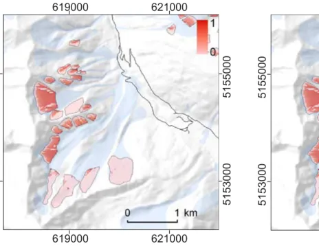
Figure 4: Fuzzy membership degree of the disposition for the release of wet snow avalanche
on sunny hillsides below 2800 m. Situation May 2
nd2001. Coordinate system: UTM N32
ETRS89.
619000 621000 5153000 5155000 5153000 5155000 619000 621000Fig. 4. Fuzzy membership degree of the disposition for the release of wet snow avalanche on sunny hillsides below 2800 m. Situation on 2 May 2001. Coordinate system: UTM N32 ETRS89.
the range between 0 and 255. This raster grid was converted into two raster-based information layers using the member-ship function illustrated in Fig. 3. For each starting zone of an avalanche path, the mean of the raster values was calcu-lated (see Fig. 4). The mean of the raster values of the in-formation layers “sunny hill slopes” or “shady hill slopes” was compared with the linguistic variable of the “hill slope position” in the avalanche bulletin. If the bulletin indicated a high release disposition of wet snow avalanches on “sunny hill slopes”, a subset of avalanche starting zones exceeding a membership degree of 0.5 of the term “sunny hill slopes” was created. From this subset, those avalanches were se-lected, that met the conditions for the minimum of a snow height about 50 cm and the altitude level of the moisture pen-etration of the snow cover indicated by the avalanche bul-letin. For these avalanche starting zones that fulfil the topo-graphic requirements indicated in the avalanche bulletin, the release of an avalanche was assumed. The avalanche release disposition was quantified by the applied rule base for the term “avalanches expected”. If no avalanches were selected due to topographic restrictions, the membership of the term “avalanches expected” was set to 0. If the avalanche bul-letin indicated only a release disposition for hill slopes ex-posed to the sun, the release disposition is determined by the minimum of the membership value of the term “avalanches expected” and the maximum of the membership values of the term “sunny hill slope” of all selected avalanche starting zones. From the GIS-dataset of the avalanche paths, the ge-ographic data of the potentially hazardous avalanche paths was selected and mapped out (see Fig. 5). It was assumed, that a) the selected avalanches trigger with the maximal
ex-28
Figure 5: Computed subset of the avalanche paths (red colour) threatening the road due to the
environmental conditions on May 2
nd2001. The universe of all avalanche paths is mapped in
slight blue. Coordinate system: UTM N32 ETRS89.
619000 621000 5153000 5155000 5153000 5155000 619000 621000
Fig. 5. Computed subset of the avalanche paths (red colour) threat-ening the road due to the environmental conditions on 2 May 2001. The universe of all avalanche paths is mapped in slight blue. Coor-dinate system: UTM N32 ETRS89.
tent of the release area as indicated in the avalanche obser-vation database; b) the selected avalanches reach the road; and c) the avalanche cross the road with an average width as indicated in the avalanche observation database. This dy-namically created hazard index map formed the basis for the calculation of the damage potential on the road. Input for the determination of the number of potentially affected persons is the mean width of the selected avalanche paths crossing the road.
2.3 Calculation of the variable damage potential on the road
To calculate the possible consequences of the hazard po-tential computed by the procedure described in the previ-ous sections, the number of persons at risk was estimated on the basis of the dynamically created hazard index map and the traffic volume (WDT). The mean daily traffic den-sity on the Sulden road is 951 vehicles per day (Autonome Provinz Bozen-S¨udtirol/ASTAT 2002) and reaches a max-imum of 2700 vehicles per day. Automatic traffic counts for the Sulden road have been recorded on a daily resolution only since 2002 (Autonome Provinz Bozen-S¨udtirol/ASTAT 2004). As the road serves as main access road to the ski area of the region, the traffic density is significantly higher during weekends and holidays than on weekdays. From the traffic observation’s database (Autonome Provinz Bozen-S¨udtirol/ASTAT 2004) results, that the traffic density is 30% above the average during weekends and 9% below the aver-age during weekdays. Thus, the traffic density for the win-ter 2000/2001 was modelled adding 30% of the mean daily
0.0 0.2 0.4 0.6 0.8 1.0 0 1 .0 3 .2 0 0 1 0 4 .0 3 .2 0 0 1 0 7 .0 3 .2 0 0 1 1 0 .0 3 .2 0 0 1 1 3 .0 3 .2 0 0 1 1 6 .0 3 .2 0 0 1 1 9 .0 3 .2 0 0 1 2 2 .0 3 .2 0 0 1 2 5 .0 3 .2 0 0 1 2 8 .0 3 .2 0 0 1 3 1 .0 3 .2 0 0 1 0 3 .0 4 .2 0 0 1 0 6 .0 4 .2 0 0 1 0 9 .0 4 .2 0 0 1 1 2 .0 4 .2 0 0 1 1 5 .0 4 .2 0 0 1 1 8 .0 4 .2 0 0 1 2 1 .0 4 .2 0 0 1 2 4 .0 4 .2 0 0 1 2 7 .0 4 .2 0 0 1 3 0 .0 4 .2 0 0 1 d a m a g e p o te n ti a l [p e rs o n s a t ri s k ] 0.0 0.2 0.4 0.6 0.8 1.0 m e m b e rs h ip v a lu e
damage potential cr closed road
(release disposition) (no avalanches expected)
cr cr 0 3 .0 5 .2 0 0 1 cr (x )
observed avalanche event
Fig. 6. Computed results of the rule base for the estimation of the release disposition. The bolt line shows the “release disposition for wet snow avalanches”. The slight line shows the result of the rules for the term “no avalanches expected”. The value of the datasets shows the membership of the parameter combination of the day to the set of days with or respective with no avalanches expected. The grey bars show the number of persons potentially affected by wet snow avalanches on the road. The blue bars show the days, on which the road was closed due to an increased avalanche hazard. The arrows show observed avalanches events in the study area.
traffic density during weekends and reducing the mean value about 9% on weekdays.
To calculate the short-term variable number of persons at risk (dp), parameters such as the mean width of avalanches crossing the road (g), the average speed of cars (v), the mean number of passengers per car (β) and the probability of death in vehicles (λ) were defined using the method of Wilhelm (1997). The calculated damage potential for every single avalanche path was subsequently summed up for the respec-tive road section (Eq. 1). As a result, the total number of per-sons at risk for the observed period (day) for the whole road segment was obtained, as shown by Zischg et al. (2005).
dp=W DT · β 24h · n X i=1 gi vi ·λi i=1, 2. . .n avalanche paths (1)
The results show the number of persons potentially affected by wet snow avalanches on the road due to the current envi-ronmental condition of the considered day. The membership degree of the term “avalanches expected” was interpreted as a possibility measure after Zadeh (1978) that describes the possibility of the occurrence of an event. This measure quan-tifies the possibility that the computed number of fatalities will occur.
3 Results
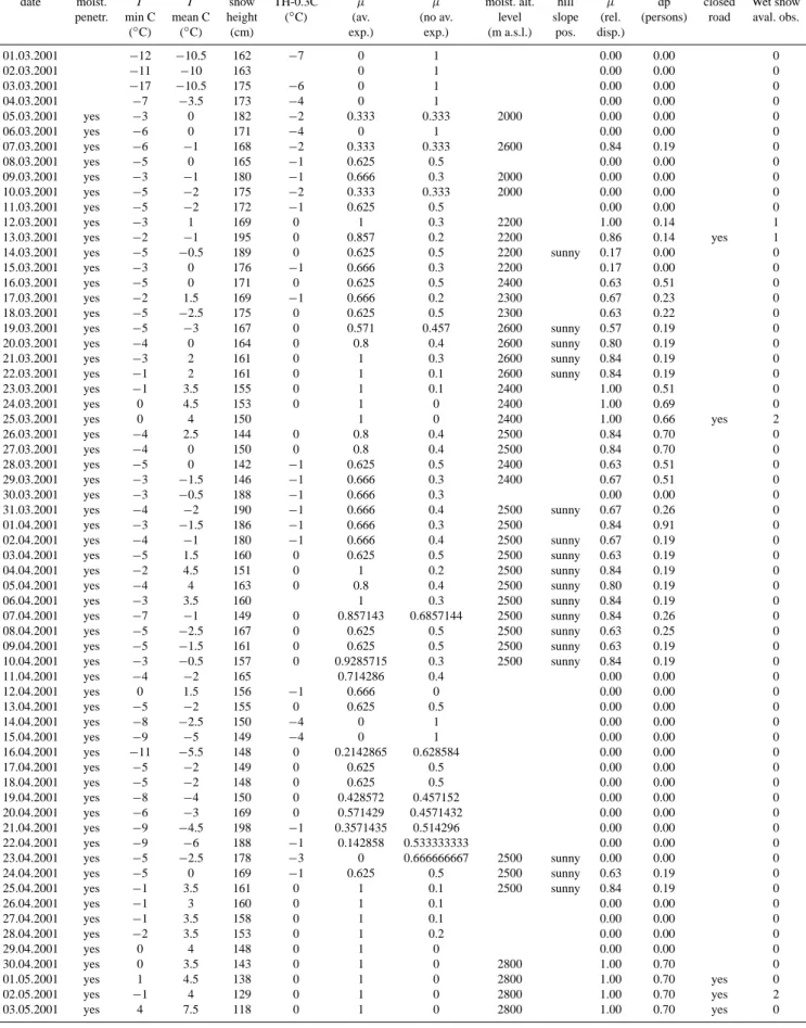
Based on the procedures described in the former sections and the parameters described in Table 3, the temporal variability of the release disposition for wet snow avalanches and the damage potential was determined on the basis of the input parameters weekday (date), moisture penetration of the snow pack (moist. penetr.), minimum of the daily air temperature (TminC), the mean of the daily air temperature, snow height, temperature of the snow pack in a depth of 30 cm (TH-0.3C), the altitude level until the snow pack is considered as wet (moist. alt. level), and the hill slope position (hill slope pos.). In Fig. 6, the results of the inference for the estimation of the release disposition are shown. The values of the datasets describe the membership of the considered day, characterised by its parameter combination, to the set of days with (µ (av. exp.)) or with no avalanches expected (µ (no av. exp.)) in the period from 1 March 2001 to 3 May 2001. For this period, the necessary input data, the avalanche bulletins, documented avalanche events in the study area and documented closures of the Sulden road due to wet snow avalanche hazard were available. On the basis of the latter datasets, the computed result of the procedure could be verified. In Fig. 6, a high temporal variability of the avalanche release disposition is
A. Zischg et al.: Monitoring of wet snow avalanche risk on roads 829
Table 3. Input parameters of the procedure and computed results.
date moist. T T snow TH-0.3C µ µ moist. alt. hill µ dp closed Wet snow
penetr. min C mean C height (◦C) (av. (no av. level slope (rel. (persons) road aval. obs.
(◦C) (◦C) (cm) exp.) exp.) (m a.s.l.) pos. disp.)
01.03.2001 −12 −10.5 162 −7 0 1 0.00 0.00 0 02.03.2001 −11 −10 163 0 1 0.00 0.00 0 03.03.2001 −17 −10.5 175 −6 0 1 0.00 0.00 0 04.03.2001 −7 −3.5 173 −4 0 1 0.00 0.00 0 05.03.2001 yes −3 0 182 −2 0.333 0.333 2000 0.00 0.00 0 06.03.2001 yes −6 0 171 −4 0 1 0.00 0.00 0 07.03.2001 yes −6 −1 168 −2 0.333 0.333 2600 0.84 0.19 0 08.03.2001 yes −5 0 165 −1 0.625 0.5 0.00 0.00 0 09.03.2001 yes −3 −1 180 −1 0.666 0.3 2000 0.00 0.00 0 10.03.2001 yes −5 −2 175 −2 0.333 0.333 2000 0.00 0.00 0 11.03.2001 yes −5 −2 172 −1 0.625 0.5 0.00 0.00 0 12.03.2001 yes −3 1 169 0 1 0.3 2200 1.00 0.14 1 13.03.2001 yes −2 −1 195 0 0.857 0.2 2200 0.86 0.14 yes 1 14.03.2001 yes −5 −0.5 189 0 0.625 0.5 2200 sunny 0.17 0.00 0 15.03.2001 yes −3 0 176 −1 0.666 0.3 2200 0.17 0.00 0 16.03.2001 yes −5 0 171 0 0.625 0.5 2400 0.63 0.51 0 17.03.2001 yes −2 1.5 169 −1 0.666 0.2 2300 0.67 0.23 0 18.03.2001 yes −5 −2.5 175 0 0.625 0.5 2300 0.63 0.22 0 19.03.2001 yes −5 −3 167 0 0.571 0.457 2600 sunny 0.57 0.19 0 20.03.2001 yes −4 0 164 0 0.8 0.4 2600 sunny 0.80 0.19 0 21.03.2001 yes −3 2 161 0 1 0.3 2600 sunny 0.84 0.19 0 22.03.2001 yes −1 2 161 0 1 0.1 2600 sunny 0.84 0.19 0 23.03.2001 yes −1 3.5 155 0 1 0.1 2400 1.00 0.51 0 24.03.2001 yes 0 4.5 153 0 1 0 2400 1.00 0.69 0 25.03.2001 yes 0 4 150 1 0 2400 1.00 0.66 yes 2 26.03.2001 yes −4 2.5 144 0 0.8 0.4 2500 0.84 0.70 0 27.03.2001 yes −4 0 150 0 0.8 0.4 2500 0.84 0.70 0 28.03.2001 yes −5 0 142 −1 0.625 0.5 2400 0.63 0.51 0 29.03.2001 yes −3 −1.5 146 −1 0.666 0.3 2400 0.67 0.51 0 30.03.2001 yes −3 −0.5 188 −1 0.666 0.3 0.00 0.00 0 31.03.2001 yes −4 −2 190 −1 0.666 0.4 2500 sunny 0.67 0.26 0 01.04.2001 yes −3 −1.5 186 −1 0.666 0.3 2500 0.84 0.91 0 02.04.2001 yes −4 −1 180 −1 0.666 0.4 2500 sunny 0.67 0.19 0 03.04.2001 yes −5 1.5 160 0 0.625 0.5 2500 sunny 0.63 0.19 0 04.04.2001 yes −2 4.5 151 0 1 0.2 2500 sunny 0.84 0.19 0 05.04.2001 yes −4 4 163 0 0.8 0.4 2500 sunny 0.80 0.19 0 06.04.2001 yes −3 3.5 160 1 0.3 2500 sunny 0.84 0.19 0 07.04.2001 yes −7 −1 149 0 0.857143 0.6857144 2500 sunny 0.84 0.26 0 08.04.2001 yes −5 −2.5 167 0 0.625 0.5 2500 sunny 0.63 0.25 0 09.04.2001 yes −5 −1.5 161 0 0.625 0.5 2500 sunny 0.63 0.19 0 10.04.2001 yes −3 −0.5 157 0 0.9285715 0.3 2500 sunny 0.84 0.19 0 11.04.2001 yes −4 −2 165 0.714286 0.4 0.00 0.00 0 12.04.2001 yes 0 1.5 156 −1 0.666 0 0.00 0.00 0 13.04.2001 yes −5 −2 155 0 0.625 0.5 0.00 0.00 0 14.04.2001 yes −8 −2.5 150 −4 0 1 0.00 0.00 0 15.04.2001 yes −9 −5 149 −4 0 1 0.00 0.00 0 16.04.2001 yes −11 −5.5 148 0 0.2142865 0.628584 0.00 0.00 0 17.04.2001 yes −5 −2 149 0 0.625 0.5 0.00 0.00 0 18.04.2001 yes −5 −2 148 0 0.625 0.5 0.00 0.00 0 19.04.2001 yes −8 −4 150 0 0.428572 0.457152 0.00 0.00 0 20.04.2001 yes −6 −3 169 0 0.571429 0.4571432 0.00 0.00 0 21.04.2001 yes −9 −4.5 198 −1 0.3571435 0.514296 0.00 0.00 0 22.04.2001 yes −9 −6 188 −1 0.142858 0.533333333 0.00 0.00 0 23.04.2001 yes −5 −2.5 178 −3 0 0.666666667 2500 sunny 0.00 0.00 0 24.04.2001 yes −5 0 169 −1 0.625 0.5 2500 sunny 0.63 0.19 0 25.04.2001 yes −1 3.5 161 0 1 0.1 2500 sunny 0.84 0.19 0 26.04.2001 yes −1 3 160 0 1 0.1 0.00 0.00 0 27.04.2001 yes −1 3.5 158 0 1 0.1 0.00 0.00 0 28.04.2001 yes −2 3.5 153 0 1 0.2 0.00 0.00 0 29.04.2001 yes 0 4 148 0 1 0 0.00 0.00 0 30.04.2001 yes 0 3.5 143 0 1 0 2800 1.00 0.70 0 01.05.2001 yes 1 4.5 138 0 1 0 2800 1.00 0.70 yes 0 02.05.2001 yes −1 4 129 0 1 0 2800 1.00 0.70 yes 2 03.05.2001 yes 4 7.5 118 0 1 0 2800 1.00 0.70 yes 0
demonstrated. The bold line shows the result of the rules for the term “avalanches expected” of the linguistic variable “re-lease disposition for wet snow avalanches”. The slight line shows the result of the rules for the term “no avalanches ex-pected”. The grey bars illustrate the computed number of persons at risk. The slight blue bars at the bottom of the figure point out the days when the road has been closed due to an elevated hazard level. On the days of the road closure, the procedure calculated a high release disposition (term “avalanches expected”). On these days, the calculated membership values for the term “no avalanches expected” were relatively low (<0.2). Thus, the difference between the concurrent rules representing the two terms was significant. The avalanche bulletin indicated an avalanche hazard level of 3 on 12 March and 4 on 13 March. On 12 March, an avalanche event in avalanche path no. 84052 occurred, but this avalanche path normally do not affect the Sulden road. In the morning of 13 March, the road had been closed due to an avalanche event in avalanche path no. 84068. The road was re-opened after the artificial release of the starting zones that had not been triggered naturally. The procedure com-puted membership values of 1.0 (12 March) and 0.86 (13 March) to the term “avalanches expected” and a membership value of 0.2 to the term “no avalanches expected”. Further-more, a damage potential of 0.14 persons at risk was calcu-lated on 13 March. From 23 to 25 March, a membership degree of 1.0 to the term “wet snow avalanches expected” and a membership degree between 0.0 and 0.1 to the term “no avalanches expected” were calculated. On these days, the avalanche bulletin indicated an avalanche hazard level of 3. The damage potential was quantified as a value up to 0.69 potentially affected persons. In the evening of 25 March, the road was closed due to an elevated hazard level. An avalanche in the avalanche path no. 84037 occurred and reached the Sulden River. In the avalanche path no. 84067, an avalanche occurred and stopped at a distance of 2 m from the road. Another elevated release disposition was computed from 30 April to 3 May. On 2 May, the avalanche bulletin predicted an avalanche hazard level of 4 at noon. On this day, avalanches in the avalanche paths no. 84044 and 84068 occurred. After the avalanche event in avalanche path no. 84068, the starting zones that had not been triggered, were released artificially. The road has been closed from 1 until 3 May. For these days, a damage potential of 0.7 potentially affected persons was calculated. A relatively high release disposition for wet snow avalanches (0.8 but not 1.0) was computed by the procedure on the days 7 March, 1 April, and 4–7 April. For these days, relatively high membership values to the term “no avalanches expected” (>0.3) were calculated. Thus, the difference between the concurrent rules represent-ing the two terms was not significant. In this case, the result of the reasoning procedure reports a considerable ambiguity in the rule base. On 7 March, a small wet snow avalanche occurred in the Stelvio Valley, outside of the study area. On the other days, no avalanches occurred. On 25 April, the pro-cedure computed a high release disposition (0.8), and a low membership value for the term “no avalanches expected”.
During this day, no avalanches were observed. In this case, the release disposition was computed as relatively high, but due to the absence of a triggering event, no avalanches oc-curred.
4 Conclusions
The validation of the procedure using data from the winter season of 2000/2001 showed that the system behaviour of wet snow avalanches can be approximately modelled with the use of only ten rules and six considered variables of sys-tem parameters. The application of this rule base to the avail-able data in the study area generated plausible results. The ex-post modelled membership degree of the conclusion term “wet snow avalanches expected” as well as the membership degree of the conclusion term “no wet snow avalanches ex-pected” represented the system behaviour well. During sit-uations when the road was closed, the procedure computed reliable results. For these situations, high membership val-ues (>0.86) for the term “wet snow avalanches expected” and low membership values (<0.3) for the term “no wet snow avalanches expected” were computed by the procedure. In the validation period, no wet snow avalanches occurred when the system computed low membership values (≤0.84) for the term “wet snow avalanches expected”. In addition to the days with observed avalanche events, a considerable dif-ference between the membership degrees of both conclusion terms was computed during the first days in March 2001, and between 11 and 23 April 2001. On these days the member-ship degree of the conclusion term “wet snow avalanches ex-pected” showed values of 0 and the membership degree of the conclusion term “no wet snow avalanches expected” showed values about 1.0 respective greater than 0.5 (see Table 3). On other days in the considered period, the membership de-grees of both conclusion terms did not represent completely complements of each other. Neither for the conclusion term “wet snow avalanches expected” nor for the conclusion term “no wet snow avalanches expected” no explicit values of 1.0 or 0 were calculated. For these situations, the incorporated rule base did not calculate unambiguous model results and considerable uncertainties in the inference procedure were pointed out. In Fig. 6, the advantages of the fuzzy set theory become obvious: A day with given environmental conditions can belong to the number of days with expected wet snow avalanches and simultaneously belong to the number of days without expected avalanches. Both statements are not con-tradictory because in the fuzzy set theory the mathematical axiom of the exclusive contradiction is not valid (Dr¨osser, 1994). If the difference between the computed membership degrees of the both conclusion terms is considerably high, the reliability of the computed results can be assessed as el-evated. The larger the difference between the membership degrees of both conclusion terms of the rules base, the more accurate a decision on risk management can be made. Oth-erwise, if both conclusion terms show a similar member-ship degree, the reliability of the result can be interpreted
A. Zischg et al.: Monitoring of wet snow avalanche risk on roads 831
as limited. On these situations a lack of knowledge about the system behaviour becomes obvious. For a better assessment of these environmental conditions, the expert’s knowledge represented by the rule base has to be extended.
The rule base implemented up until now only represents a simplified picture of the reality. However, assessing the time variable disposition for the release of wet snow avalanches by using the expert system approach rather than on the ba-sis of empirically determined relationships between environ-mental parameters and avalanche releases as shown by Zis-chg et al. (2005) opens up new possibilities for modelling the system behaviour of complex non-linear processes. In the possibility of combining numeric and non-numeric data or observations, the benefits of the fuzzy set theory are high-lighted. The determination of the uncertainties and the infor-mation about the reliability of the knowledge base applied to the current environmental conditions leads to a better evalua-tion of the computed results and the reliability of the model. Nevertheless, the triggering event of wet snow avalanches cannot be modelled by the presented approach.
Fuzzy logic based inference engines are robust (Zimmer-mann, 1993); they primarily react to changes in the knowl-edge base. The higher the number of rules and the consid-ered variables the more meaningful is the conclusion result. Thus, in the design phase of building an expert system the focus has to be directed to the representation of the expert’s knowledge. Furthermore, the applied implication and aggre-gation operators have significant influences on the results of the inference engine. The choice of these operators depends on the rule base and the number of variables considered in the reasoning process.
As presented in Fig. 6, the variability of damage potential due to wet snow avalanches can be estimated based on the ac-tual environmental conditions. The computed values showed a high short-term temporal variability. This seems consistent with findings presented by Zischg et al. (2005) and Keiler et al. (2005) in the context of alpine settlements. The consider-ation of the temporal variability of the damage potential pro-vide information for risk management and can thus improve the quality of decision making processes.
The input data used in the development of the procedure had been recorded at a distance of 20 km from the study area. Although this source of impreciseness was considered by the use of fuzzy variables, the results of the expert systems prob-ably could be more specified and accurate using input data from a weather and snow measurement station located in the study area. The procedure was developed using only a few environmental parameters. Further research is needed par-ticularly regarding the implementation of other parameters for the determination of the release disposition for wet snow avalanches and regarding the extension of the rule base. The consideration of more parameters is possible adding more rules and parameters in the knowledge base of the expert system. The software for the inference engine must not be adapted in the case of an extension of the knowledge base. The described method could be enhanced by including addi-tional components such as models for a computer-aided
as-sessment of snow pack stability (e.g. Lehning et al., 1999), or numerical avalanche forecasting (e.g. Brabec, 2001). Nev-ertheless, the approach may demonstrate the potential for the application of expert systems and fuzzy logic in the field of natural hazard monitoring and risk management.
Acknowledgements. The authors thank M. Munari, C. Ober-schmied, C. Mutinelli, and H. Stuefer (Avalanche Warning Service, Autonomous Province of Bozen, South Tyrol, Italy) for providing the data.
Edited by: T. Glade
Reviewed by: R. Sailer and another referee
References
Armstrong, R. L. and Yves, J. D.: Wet Snow Avalanches. Avalanche Release and Snow Characteristics. Occasional Paper no. 19, In-stitute of Arctic and Alpine Research, University of Colorado, 67–81, 1976.
Autonome Provinz Bozen-S¨udtirol/ASTAT: Verkehrsstatistik in S¨udtirol 2001, Bozen, 2002.
Autonome Provinz Bozen-S¨udtirol/ASTAT: Online traffic database, 2004, http://www.provinz.bz.it/astat/daten online/default.htm, 2 August 2004.
Autonome Provinz Bozen-S¨udtirol/Lawinenwarndienst: Schl¨ussel f¨ur Meteonivometrische Beobachtungen an Schneemessfeldern, Bozen, 1983.
Autonome Provinz Bozen-S¨udtirol/Lawinenwarndienst: Kodex f¨ur Wetter und Schnee Beobachtungen, Bozen, 1997.
Barbolini, M., Natale, L., and Savi, F.: Effects of Release Condi-tions Uncertainty on Avalanche, Nat. Haz., 25, 225–244, 2002. Bell, R. and Glade, T.: Quantitative risk analysis for landslides
– Examples from Bildudalur, NW-Iceland, Nat. Hazards Earth Syst. Sci., 4, 117–131, 2004,
SRef-ID: 1684-9981/nhess/2004-4-117.
Bolognesi, R.: Artificial Intelligence and Local Avalanche Fore-casting: The System “AVALOG”, International Emergency and Engineering Conference, Arlington VA, San Diego, California, USA, 1993, edited by: Soc. of Computer Science (S.C.S.), 113– 116, 1993.
Bolognesi, R., Buser, O., and Good, W.: Local avalanche forecast-ing in Switzerland: strategy and tools, a new approach, Inter-national Snow Science Workshop 1994, Snowbird, Utah, USA, 463–472, 1994.
Borter, P.: Risikoanalyse bei gravitativen Naturgefahren, edited by BUWAL Bundesamt f¨ur Umwelt, Wald und Landschaft, Bern, 1999.
Bothe, H. H.: Fuzzy Logic, Einf¨uhrung in Theorie und Anwendun-gen, Berlin, Heidelberg, 1995.
Brabec, B.: Computergest¨utzte regionale Lawinenprognose, Diss. ETH/SLF No. 14232, ETH Z¨urich, Z¨urich, 2001.
Br¨undl, M., Etter, H.-J., Steiniger, M., Klingler, C., Rhyner, J., and Ammann, W.: IFKIS – a basis for managing avalanche risk in settlements and on roads in Switzerland, Nat. Hazards Earth Syst. Sci., 4, 257–262, 2004,
SRef-ID: 1684-9981/nhess/2004-4-257.
Buisson, L. and Charlier, C.: Avalanche starting-zone analysis by use of a knowledge-based system, Ann. Glaciol., 13, 27–30, 1989.
Buisson, L. and Charlier, C.: Avalanche modelling and integration of expert knowledge in the ELSA system, Ann. Glaciol, 18, 123– 128, 1993.
Buisson, L. and Giraud, G.: Two examples of Expert Knowledge based Systems for Avalanche Forecasting and Protection, Surv. Geophys., 16, 603–619, 1995.
Cox, E.: The fuzzy systems handbook, New York, 1999.
Dr¨osser, C.: Fuzzy Logic, Methodische Einf¨uhrung in krauses Denken, Hamburg, 1994.
Durand, Y., Giraud, G., Brun, E., Merindol, L., and Martin, E.: A computer-based system simulating snowpack structures as a tool for regional avalanche forecasting, J. Glaciol., 45, 469–484, 1999.
Jackson, P.: Introduction to Expert Systems, New York, 1999. Keiler, M., Zischg, A., Fuchs, S., Hama, M., and St¨otter, J.:
Avalanche related damage potential – changes of persons and mobile values since the mid-twentieth century, Nat. Hazards Earth Syst. Sci., 5, 49–58, 2005,
SRef-ID: 1684-9981/nhess/2005-5-49.
Kienholz, H.: Early warning systems related to mountain hazards, in: Early warning systems for natural disaster reduction, edited by: Zschau, J. and K¨uppers, A. N., Berlin, Heidelberg, New York, 555–564, 2003.
Kleemayr, K., Moser, A., Sch¨oll, J., and Vollsinger, S.: Lawinen-prognose mit statistischen und selbstlernenden Verfahren im Pro-jekt “NAFT”, Schutz des Lebensraumes vor Hochwasser, Muren und Lawinen, Proc. Intern. Symp. Interpraevent 2000, Villach, Austria, 411–422, 2000.
LaChapelle, E. R.: Snow avalanches: a review of current research and applications, J. Glaciol., 19, 313–323, 1977.
Lehning, M., Bartelt, P., Brown, B., Russi, T., Stockli, U., and Zim-merli, M.: SNOWPACK model calculations for avalanche warn-ing based upon a new network of weather and snow stations, Cold Reg. Sc., 30, 145–157, 1999.
Margreth, S., Stoffel, L., and Wilhelm, C.: Winter opening of high alpine pass roads – analysis and case studies from the Swiss Alps, Cold Reg. Sc. 37, 467–482, 2003.
McClung, D. M.: Computer assistance in avalanche forecasting. Proceedings of the International Snow Science Workshop 1994, Snowbird, Utah, USA, 310–313, 1995a.
McClung, D. M.: Use of Expert Knowledge in Avalanche Forecast-ing, Def. Sc. J., 45, 117–123, 1995b.
McClung, D. M. and Schaerer, P. A.: The avalanche handbook, Seattle, 1993.
Mittra, S. S.: Decision Support Systems, Tools and Techniques, New York, 1986.
Rodriguez-Bachiller, A. and Glasson, J.: Expert systems and ge-ographical information systems for impact assessment, London, 2004.
Sailer, R.: Risk Assessment and Crisis Management for a winter tourist resort (St. Anton a/A, Tyrol, Austria) – a case study. Pro-ceedings of the First Annual IIASA-DPRI Meeting on Integrated Disaster Risk Management: Reducing Socio-Economic Vulner-ability, IIASA, Laxenburg, Austria, 2001.
Schweizer, J. and F¨ohn, P.M.B.: Avalanche forecasting – an expert system approach, J. Glaciol., 42, 318–332, 1996.
Schweizer, M., F¨ohn, P. M. B., Schweizer, J., and Ultsch, A.: A Hybrid Expert System for Avalanche Forecasting, in: Informa-tion and CommunicaInforma-tion Technologies in Tourism, Edited by: Schertler, W., Schmid, B., Tjoa, A. M., and Werthner, H., New York, 148–153, 1994.
Sprague, R. H. J. and Watson, H. J.: Decision Support Systems, Putting Theory into Practice, London, 1986.
UN/ISDR: Living with Risk – A global review of disaster reduction initiatives, 2004 Version, 1, Geneva, 2004.
Wilhelm, C.: Wirtschaftlichkeit im Lawinenschutz, edited by SLF Eidgen¨ossisches Institut f¨ur Schnee- und Lawinenforschung, Mitt. 54, Davos, 1997.
Zadeh, L. A.: Fuzzy sets. Inform. Contr., 8, 338–353, 1965. Zadeh, L. A.: The concept of a linguistic variable and its application
to approximate reasoning–I., Inform. Sc., 8, 199–249, 1975. Zadeh, L. A., Fuzzy sets as a basis for a theory of possibility, Fuzzy
Sets Syst., 1, 3–28, 1978.
Zimmermann, H. J.: Fuzzy Technologien. Prinzipien, Werkzeuge, Potentiale, D¨usseldorf, 1993.
Zimmermann, H. J.: An application-oriented view of modelling un-certainty, Eur. J. Op. Res., 122, 190–198, 2000.
Zimmermann, M., Mani, P., and Gamma, P.: Murganggefahr und Klima¨anderung – ein GIS-basierter Ansatz, Z¨urich, 1997. Zischg, A.: Analyse des Systemverhaltens von Nassschneelawinen
als Basis f¨ur die Generierung von dynamischen Gefahrenhin-weissystemen am Beispiel der Ortlergruppe (S¨udtirol), Proc. Intern. Symp. Interpraevent 2004 – Riva del Garda, VI/229– VI/240, 2004.
Zischg, A., Fuchs, S., Keiler, M., and J. St¨otter: Temporal variabil-ity of damage potential on roads as a conceptual contribution to-wards a short-term avalanche risk simulation, Nat. Hazards Earth Syst. Sci., 5, 235–242, 2005,
SRef-ID: 1684-9981/nhess/2005-5-235.
Zischg, A., Fuchs, S., and St¨otter, J.: Uncertainties and fuzziness in analysing risk related to natural hazards – A case study in the Ortles Alps, South Tyrol, Italy, in: Risk Analysis IV, edited by: Brebbia, C., Management Information Systems 9, Southampton, 523–532, 2004.