HAL Id: hal-00297009
https://hal.archives-ouvertes.fr/hal-00297009
Submitted on 15 Jun 2007
HAL is a multi-disciplinary open access
archive for the deposit and dissemination of
sci-entific research documents, whether they are
pub-lished or not. The documents may come from
teaching and research institutions in France or
abroad, or from public or private research centers.
L’archive ouverte pluridisciplinaire HAL, est
destinée au dépôt et à la diffusion de documents
scientifiques de niveau recherche, publiés ou non,
émanant des établissements d’enseignement et de
recherche français ou étrangers, des laboratoires
publics ou privés.
Assessment of nutrient entry pathways and dominating
hydrological processes in lowland catchments
B. Schmalz, F. Tavares, N. Fohrer
To cite this version:
B. Schmalz, F. Tavares, N. Fohrer. Assessment of nutrient entry pathways and dominating hydrological
processes in lowland catchments. Advances in Geosciences, European Geosciences Union, 2007, 11,
pp.107-112. �hal-00297009�
www.adv-geosci.net/11/107/2007/ © Author(s) 2007. This work is licensed under a Creative Commons License.
Geosciences
Assessment of nutrient entry pathways and dominating hydrological
processes in lowland catchments
B. Schmalz, F. Tavares, and N. Fohrer
Dept. Hydrology and Water Resources Management, Ecology Centre, Kiel, Germany
Received: 15 January 2007 – Revised: 11 April 2007 – Accepted: 22 May 2007 – Published: 15 June 2007
Abstract. The achievement of a good water quality in all
water bodies until 2015 is legally regulated since December 2000 for all European Union member states by the Euro-pean Water Framework Directive (EU, 2000). The aim of this project is to detect nutrient entry pathways and to assess the dominating hydrological processes in complex mesoscale catchments.
The investigated Treene catchment is located in Northern Germany as a part of a lowland area. Sandy, loamy and peat soils are characteristic for this area. Land use is domi-nated by agriculture and pasture. Drainage changed the nat-ural water balance. In a nested approach we examined two catchment areas: a) Treene catchment 517 km2, b) Kielstau catchment 50 km2. The nested approach assists to improve the process understanding by using data of different scales. Therefore these catchments serve not only as an example but the results are transferable to other lowland catchment areas. In a first step the river basin scale model SWAT (Soil and Water Assessment Tool, Arnold et al., 1998) was used suc-cessfully to model the water balance. Furthermore the wa-ter quality was analysed to distinguish the impact of point and diffuse sources. The results show that the tributaries in the Kielstau catchment contribute high amounts of nutrients, mainly nitrate and ammonium. For the parameters nitrate, ammonium and phosphorus it was observed as a tendency that the annual loads were increasing along the river profile of the Kielstau.
1 Introduction
The achievement of a good water quality in all water bod-ies until 2015 is legally regulated since December 2000 for all European Union member states by the European Water
Correspondence to: B. Schmalz
Framework Directive (EU, 2000). It sets up an examination of river catchments as spatial units and of interactions be-tween water bodies and their environment.
Lowland areas are characterized by special properties like flat topography and low hydraulic gradients. Furthermore there is near-surface groundwater which results in a high groundwater – stream water interaction. Various river reg-ulations, pumping stations and drainage systems like tile drainage and open ditches changed the natural water balance. Due to that a fast nutrient transport influences the instream water quality.
As nutrient entry pathways in rivers diffuse and punctual sources are thinkable (Pieterse et al., 2003; Meynendonckx et al., 2006; Wood et al., 2005). In catchment areas nutrient entries from agriculture (fertilizer, pesticides, animal hus-bandry in river vicinity) as well as from settlements (waste water, traffic routes) play a role. An assessment is feasible through measurements and with ecohydrological modelling in relation to water balance and quality.
The objective of this project is the assessment of the nu-trient entry pathways and the dominating hydrological pro-cesses in a complex mesocale lowland catchment area. First results from measurements and ecohydrological modelling are presented.
2 Investigation area
The mesoscale investigation area is located in Northern Ger-many as a part of a lowland area of Schleswig-Holstein. Sandy, loamy and peat soils are characteristic for the catch-ment. Landuse is dominated by agriculture and pasture. The maximum height difference is 76 m for the entire area, and about 40 m for the eastern part. The precipitation is 872 mm/a and the mean annual temperature 8.2◦C.
108 B. Schmalz et al.: Assessment of nutrient entry pathways in lowland catchments
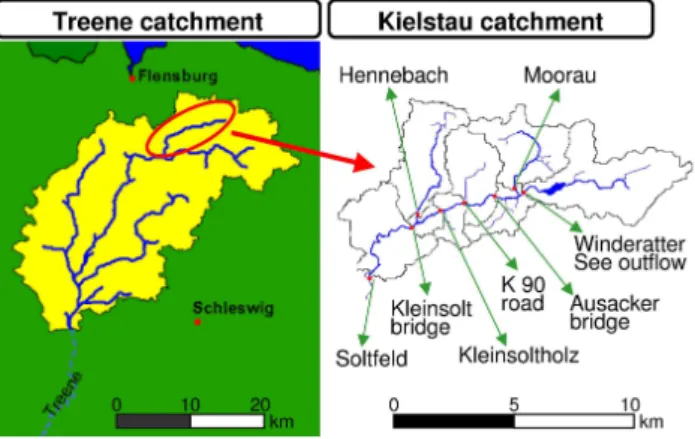
Fig. 1. Treene watershed (left; Dey, 2005) and its subcatchment Kielstau (right) with eight measuring stations and the model sub-catchments.
In a nested approach we examine two catchment areas, which cover different scales:
a) Treene catchment 517 km2, 60 km river length, b) Kielstau catchment 50 km2, 11 km river length
From the Treene catchment only that area without tide in-fluence was considered.
The river Kielstau has its origin in the lake Winderatter See and has two important tributaries from the north, the Moorau and the Hennebach (Fig. 1). In addition various smaller trib-utaries and water from drainage pipes and open ditches flow into the Kielstau. The drained fraction of agricultural area in the Kielstau catchment is estimated 38% (Fohrer et al., 2007). One wastewater treatment plant is situated at the be-ginning of the Moorau, another three are located in the vicin-ity of the Hennebach.
3 Methods
Measured and investigated data form the basis for the anal-ysis and modelling. In measurement campaigns discharge and water quality were measured weekly from April 2005 till March 2006 at eight stations along the river profile of the river Kielstau and the two tributaries Moorau and Hen-nebach. The first station is situated circa 700 m from the lake outflow, the last station is gauge Soltfeld at the catch-ment outlet. Temperature, pH, electrical conductivity, oxy-gen, NH4, NO3, PO4, Ptot, Cl and SO4 were analysed in field and lab.
There are two steps to tackle the project goals:
1. Ecohydrological modelling: The river basin model SWAT (Soil and Water Assessment Tool, Version AVSWAT2000, Arnold et al., 1998) was used in order to reproduce the water balance in these complex hy-drologic catchment areas. SWAT is a semi-distributed,
process oriented model for simulating water, nutrient and pesticide transport. Simulations are conducted for mesoscale catchments and their Hydrological Re-sponse Units (HRU; hydrotopes). The Treene model is based on data (1984–2000) from eight gauges, the Kielstau model on data from 1986–2005. Both mod-els are based on data of own measuring campaigns and also from German authorities and institutions like Lan-desamt f¨ur Natur- und Umwelt des Landes Schleswig-Holstein (LANU-SH), Deutscher Wetterdienst (DWD), Deutsches Zentrum f¨ur Luft- und Raumfahrt (DLR) and Staatliches Umweltamt in Schleswig (StUA-Schleswig) (see in detail in Dey (2004) and Tavares (2006)). Both models are used at daily steps.
2. Assessment: Water quality data and calculated loads in the Kielstau catchment were assessed in a detailed anal-ysis. A general classification was conducted using the “LAWA procedure for the chemical classification of wa-ter bodies” (LAWA, 1998). In this paper we focus on the N and P components.
4 Results
4.1 Ecohydrological modelling
The ecohydrological modelling with SWAT was conducted by dividing the Treene catchment into 681 hydrotopes and 58 subcatchments (Dey, 2004), and the Kielstau catchment into 117 hydrotopes and 8 subcatchments. First modelling runs dealed with problems in simulating the stream flow cor-rectly. They showed an underestimation of measured high winter discharge peaks, early response discharges in the late summer periods peaks and an overestimation of base flow mainly during the summer. Thus the modelled discharge dy-namic was too small. According to the conditions in this lowland catchments several options were taken into consider-ation referring to the groundwater storage and drainage. For the Treene model 14% drainage, an increase of the reces-sion coefficient ALPHA BF to 0.0286 (at the outlet) and a percolation time of two days for the hilly area were consid-ered (Dey, 2004; Dey et al., 2004). For the Kielstau catch-ment a groundwater retention time of 50 days, an installa-tion of ponds and wetlands as well as drainage (DDRAIN as 600 mm and TDRAIN as 24 h) were included. Figure 2 shows as an example the stepwise calibration of the SWAT model for the Kielstau. Thereafter the modelling of the wa-ter balance with SWAT both of the Treene and of the Kielstau catchment areas showed a good correlation between mea-sured and modelled discharges (Table 1, Figs. 3 and 4). The discharge dynamics were reproduced in a better way.
Table 1. Performance of models relating to the catchment outlets (*Dey, 2004; Fohrer et al., 2006).
period Nash-Sutcliffe index correlation coefficient
Treene calibration* 1994–1995 0.89 0.95
Treene validation* 1997–2000 0.86 0.94
Kielstau calibration 01.01.1990–31.12.1999 0.71 0.82 Kielstau validation 01.01.2000–01.05.2005 0.63 0.75
Fig. 2. Statistical development of model efficiency and cor-relation during the calibration steps. A = Base Model, B = GW DELAY: 200 d, C = GW DELAY: 50 d; GWQMN: 1250 mm, D = GW REVAP: 0.2, E = REVAPMN: 0.01 mm, F = Ponds & Wetlands, G = Drainage, H = CN2 adjustments.
Fig. 3. Measured and modelled daily discharge at the catchment outlet of the Treene catchment during calibration (Dey, 2004).
4.2 Water quality assessment
Because of the complexity of processes in both hydrologic catchments we first looked in detail on the matter transport processes in the Kielstau catchment.
Along the river profile it was observed that the nitrogen concentrations were relatively small at the beginning of Kiel-stau, while the tributary Moorau supplied clearly increased NO3 N concentrations and a second tributary Hennebach in-creased NH4 N concentrations (Fig. 5). Possible sources are agriculture (fertilizer and a poultry farm in the middle of the Moorau) and/or wastewater treatment plants.
Fig. 4. Measured and modelled daily discharge at the catchment outlet of the Kielstau catchment during calibration.
Fig. 5. Annual average concentrations of nitrate nitrogen (mg/l), ammonium nitrogen (mg/l), pH and water temperature (◦C) in all
measurement stations investigated in the Kielstau. The tributaries are displayed in the river course where their waters join the Kielstau.
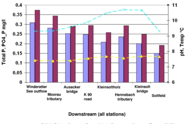
The measurements of phosphorus show opposite results (Fig. 6). The highest concentrations are at the beginning of the Kielstau and the water was then diluted in the river course. Probably the phosphate is set free from the sediment within the area of the lake at the beginning of the Kielstau. A current entry from the extensive agriculture is not so probable in that area deduced from field observations. From former times with intensive agriculture around the lake phosphate could be stored in the sediment. The lake water itself has no
110 B. Schmalz et al.: Assessment of nutrient entry pathways in lowland catchments
Fig. 6. Annual average concentrations of total phosphorus (mg/l), phosphate phosphorus (mg/l), pH and water temperature (◦C) in all
measurement stations investigated in the Kielstau. The tributaries are displayed in the river course where their waters join the Kielstau.
high concentrations. The influence of a fen between the lake outlet and the first sampling point has to be clarified.
These observations were not only recognized by the an-nual values but could be confirmed by single observations in all four seasons. These observations allow the presumption that the major ammonium nitrogen and nitrate nitrogen nu-trients are supplied by the Moorau tributary. The Hennebach revealed also an important role as ammonium nitrogen sup-plier.
Looking especially at the water quality of the Moorau and the close-by stations upstream and downstream in the main channel a general classification can be shown using the “LAWA procedure for the chemical classification of water bodies” (LAWA, 1998):
The LAWA classification in station Winderatter See out-flow placed nitrate nitrogen concentrations within class I (zero burden) during the summer period. During winter the LAWA classification of significant burden (class II–III) was obtained. In one occasion (12.04.2005) the LAWA class en-hanced burden (class III) was reached. The Moorau station presents a completely different situation, with the achieve-ment of LAWA class III during most of the year. Throughout the summer period the significant burden classification was many times reached and in two occasions (12.04.2005 and 18.10.2005) class III–IV (great burden). In the downstream sampling station Ausacker bridge most of the year was clas-sified as having a significant burden. This status was left once to reach zero burden class in 30.08.2005, in four occa-sions enhanced burden, and at 12.05.2005 the great burden class.
In the Winderatter See outflow station the ammonium
ni-trogen concentrations reached during the summer period the
LAWA class IV (very great burden). In the winter period concentrations were mostly within LAWA class II (moderate
burden). At Moorau station with a worse quality situation, in several occasions of the year, the LAWA class IV was reached. During the remaining period mostly LAWA class II was observed. The concentrations in Ausacker bridge sta-tion were predominantly within LAWA class II. However, in four occasions LAWA class IV was present and in other two occasions LAWA class III-IV was observed.
During most of the year the Winderatter See station pre-sented phosphate phosphorus concentrations within LAWA class III-IV, being the class IV was achieved during the mid-dle of July. In October LAWA class III were often and, in the beginning of May and November class II-III were reached. Most of the winter period was classified as having a moderate burden. At the Moorau station the concentrations were most of the year classified as LAWA class III. In two occasions (July and end of September) classification III-IV and once during December classification II were reached. The same classification tendency was revealed at measurement station Ausacker bridge. The LAWA classification for total
phos-phorus is in its majority similar to the classification tendency
showed by phosphate phosphorus.
Looking in detail at the water quality at the catchment’s outlet at Soltfeld the following classification was found: Most of the year nitrate nitrogen concentrations were clas-sified within LAWA class II–III. In the winter period some occurrences of the class III were verified. For ammonium nitrogen the LAWA class IV was only reached once during the month of August. In one occasion (end of January) the class III–IV was observed. In the remaining period the concentrations were mostly distributed through the LAWA classes II and II–III. For phosphate phosphorus the class III–IV was never reached. From the middle of July until middle of August concentrations were found within LAWA class III and during most of the cold period the class II was reached.
Loads
For a better understanding of the tributaries influence on water quality nutrient loads were calculated by using observed discharge values.
Annual discharge in the tributaries is with about 2 m3/s clearly lower than in the main river (Figs. 7 and 8). There-fore the high concentrations resulted in lower loads, but were an essential addition to the stream loads. The loads of the Moorau were even higher than the loads at the lake outlet for the parameters nitrate nitrogen, ammonium nitrogen and both phosphorus parameters (Figs. 7 and 8). In all parame-ters a general increase in the loads is observed with increas-ing downstream distance in the main stream channel, except the small annual load from the Hennebach tributary.
To further investigate the influence of the tributaries it was calculated the load difference between the tributary down-wards station and the load sum of tributary and station up-wards from the tributary: The load sums of Winderatter See
Fig. 7. Annual loads (kg/s) of nitrate nitrogen, ammonium nitrogen, and annual sum of runoff at all Kielstau stations and their tributaries.
Fig. 8. Annual loads (kg/s) of total phosphorus, phosphate phos-phorus and annual sum of runoff at all Kielstau stations and their tributaries.
outlet with Moorau tributary were always lower than the loads of Ausacker bridge which leads to the conclusion that the load increment in the downward point of the tributaries is mainly a consequence of joining one more branch to the main stream.
The nitrate nitrogen load observed in Kleinsolt bridge is only slightly higher as the sum of the loads observed at Kleinsoltholz and Hennebach tributary, but were nearly the same for ammonium nitrogen and both phosphorus parame-ters (Figs. 7 and 8).
5 Conclusions
The Treene catchment area and its subcatchment Kielstau in Northern Germany served as an example for lowland ar-eas but the assessed results are however transferable to other lowland catchment areas. The nutrient entry pathways into rivers from diffuse and punctual sources and the
dominat-ing hydrological processes were derived from measurements and ecohydrological modelling. First of all the water bal-ance was successfully simulated with the ecohydrological mesoscale model SWAT. For the Treene it was achieved a Nash-Sutcliffe Index of 0.89 (correlation: 0.95), for the Kiel-stau catchment of 0.71 (0.82).
Afterwards the entries from agriculture, wastewater treat-ment plants and seditreat-ment release were regarded and the in-fluence of tributaries on the main channel water quality was determined. The results show that the tributaries in the Kiel-stau catchment contribute high amounts of nutrients mainly nitrate and ammonium. For the parameters nitrate, ammo-nium and phosphorus it was observed as a tendency that the annual loads were increasing along the river profile of the Kielstau. It can be noticed that both diffuse sources like ni-trate entries from the agriculture and point sources such as wastewater treatment plants with mainly ammonium entries affect the water quality in the stream water.
The various measurements on different scales permit the understanding of transport processes in the investigation ar-eas. A nested approach can be used to improve examinations on the catchment scale by using analyses of processes on lo-cal slo-cale (subcatchments).
In the future the water quality and the point sources are to be considered within the ecohydrological model. Thus a better quantification of the agricultural entry pathways, a differentiation into point and diffuse sources with considera-tion of the management opconsidera-tions and an evaluaconsidera-tion of poten-tial changes of management are assessable.
Edited by: K.-E. Lindenschmidt Reviewed by: B. Guse and H. Nacken
References
Arnold, J.-G., Srinivasan, R., Muttiah, R. S., and Williams, J. R.: Large area hydrologic modelling and assessment, Part I: Model development, J. Am. Water Resour. As.,34(1), 73–89, 1998. Dey, T.: R¨aumlich differenzierte Einzugsgebietsmodellierung
f¨ur den tidefreien Bereich der Treene, Diplomarbeit im Fach Geographie, Okologie-Zentrum¨ Christian-Albrechts-Universit¨at Kiel, 79p., http://www.hydrology.uni-kiel.de/lehre/ abschlussarbeiten/da tdey.pdf, 2004.
Dey, T., Horn, A., H¨ormann, G., and Fohrer, F.: R¨aumlich differen-zierte Einzugsgebietsmodellierung am Beispiel des tidefreien Bereichs der Treene, In: Ludwig, R., Reichert, D. and Mauser, W. (eds): 7. Workshop zur großskaligen Modellierung in der Hydrologie: Neue methodische Ans¨atze zur Modellierung der Wasser- und Stoffums¨atze in großen Einzugsgebieten, M¨unchen, November 2003, 209p., Kassel University Press, 111-122, 2004. Dey, T.: http://www.treenemodell.de/lage.htm, assess 08.01.2007,
2005.
EU: Richtlinie 2000/60/EG des Europ¨aischen Parlaments und des Rates vom 23.10.2000 zur Schaffung eines Ordnungsrahmens f¨ur Maßnahmen der Gemeinschaft im Bereich der Wasserpolitik, Amtsblatt der Europ¨aischen Gemeinschaften, 2000.
112 B. Schmalz et al.: Assessment of nutrient entry pathways in lowland catchments
Fohrer, N., Dey, T., Dobslaff, N., and H¨ormann, G.: R¨aumlich dif-ferenzierte hydrologische Modellierung norddeutscher Tieflan-deinzugsgebiete am Beispiel der Treene und der St¨or, Ecosys. Suppl., 46, 107–120, 2006.
Fohrer, N., Schmalz, B., Tavares, F., and Golon, J.: Ans¨atze zur Integration von landwirtschaftlichen Dr¨anagen in die Mod-ellierung des Landschaftswasserhaushalts von mesoskaligen Tieflandeinzugsgebieten, Hydrologie & Wasserbewirtschaftung, in print, 2007.
LAWA (L¨anderarbeitsgemeinschaft Wasser): Beurteilung der Wasserbeschaffenheit von Fließgew¨assern in der Bundesrepub-lik Deutschland, Chemische Gew¨asserg¨uteklassifikation, Hrsg. L¨anderarbeitsgemeinschaft Wasser, Bearb. LAWA-Arbeitskreis “Zielvorgaben” in Zusammenarbeit mit LAWA-Arbeitskreis “Qualitative Hydrologie der Fließgew¨asser”, Kulturbuchverlag Berlin, 69 S., 1998.
Meynendonckx, J., Heuvelmans, G., Muys, B., and Feyen, J.: Ef-fects of watershed and riparian zone characteristics on nutrient concentrations in the River Scheldt Basin, Hydrol. Earth Syst. Sci., 10, 913–922, 2006,
http://www.hydrol-earth-syst-sci.net/10/913/2006/.
Pieterse, N. M., Bleuten, W., and Jorgensen, S. E.: Contribution of point sources and diffuse sources to nitrogen and phosphorus loads in lowland river tributaries, J. Hydrol., 271, 213–225, 2003. Tavares, F.: Continuous, spatially distributed, stream flow and quality assessment of a lowland catchment in Northern Germany, Masterarbeit im Studiengang “Environmental Management”,
¨
Okologie-Zentrum Christian-Albrechts-Universit¨at Kiel, 134p., http://www.hydrology.uni-kiel.de/lehre/abschlussarbeiten/ msc tavares.pdf, 2006.
Wood, F. L., Heathwaite, A. L., and Haygarth, P. M.: Evaluating diffuse and point phosphorus contributions to river transfers at different scales in the Taw catchment, Devon, UK, J. Hydrol., 304, 118–138, 2005.