HAL Id: hal-02136820
https://hal.archives-ouvertes.fr/hal-02136820
Submitted on 22 May 2019
HAL is a multi-disciplinary open access
archive for the deposit and dissemination of
sci-entific research documents, whether they are
pub-lished or not. The documents may come from
teaching and research institutions in France or
abroad, or from public or private research centers.
L’archive ouverte pluridisciplinaire HAL, est
destinée au dépôt et à la diffusion de documents
scientifiques de niveau recherche, publiés ou non,
émanant des établissements d’enseignement et de
recherche français ou étrangers, des laboratoires
publics ou privés.
Distributed under a Creative Commons Attribution - NoDerivatives| 4.0 International
Procedural Tectonic Planets
Yann Cortial, Adrien Peytavie, Eric Galin, Eric Guérin
To cite this version:
Yann Cortial, Adrien Peytavie, Eric Galin, Eric Guérin. Procedural Tectonic Planets. Computer
Graphics Forum, Wiley, 2019, 38 (2). �hal-02136820�
Procedural Tectonic Planets
Y. Cortial1, A. Peytavie2, E. Galin2and E. Guérin1
1LIRIS-CNRS INSA de Lyon 2LIRIS-CNRS Université de Lyon
Abstract
We present a procedural method for authoring synthetic tectonic planets. Instead of relying on computationally demanding physically-based simulations, we capture the fundamental phenomena into a procedural method that faithfully reproduces large-scale planetary features generated by the movement and collision of the tectonic plates. We approximate complex phenomena such as plate subduction or collisions to deform the lithosphere, including the continental and oceanic crusts. The user can control the movement of the plates, which dynamically evolve and generate a variety of landforms such as continents, oceanic ridges, large scale mountain ranges or island arcs. Finally, we amplify the large-scale planet model with either procedurally-defined or real-world elevation data to synthesize coherent detailed reliefs. Our method allows the user to control the evolution of an entire planet interactively, and to trigger specific events such as catastrophic plate rifting.
CCS Concepts
• Computing methodologies → Computer graphics; Shape modeling;
1. Introduction
Modeling virtual landscapes has been one of the goals of computer graphics for several decades. Although a vast variety of techniques have been proposed for generating virtual terrains, few attempts have been made to synthesize entire planets. The challenge stems not only from the scale of the domain that needs to be generated (hundreds of millions of square kilometers, i.e. ≈ 108 km2) but also from the diversity and consistency of landforms and oceanic features at different scales that need to be synthesized.
We address the challenging problem of allowing the user to interactively control the synthesis of virtual planets by shaping continents, oceanic ridges, islands arcs, archipelagos, and large scale mountain ranges, plateaus, plains or seas. Existing approaches mostly rely on fractal synthesis based on coherent noise functions or stochastic displacement and do not capture the complex shape of continents and large-scale characteristic landform features. Our work comes from the observation that the shape of continents and islands is determined by several interdependent phenomena trig-gered by tectonic forces.
Plate tectonics is a crust kinematic theory fitting observed geo-physical data [Mor68,LP68]. Recent research on mantle dynamics shows that the movement, the shape and the deformations of the plates result from the convection phenomena occurring in the man-tle [BTR15]. Mantle dynamics simulations are the focus of active research by geophysicists, but major challenges still remain to be overcome. Simulating mantle convection and plate tectonics as a self-organized system [CGU17] remains a challenging and com-putationally demanding problem in geophysics [CS17].
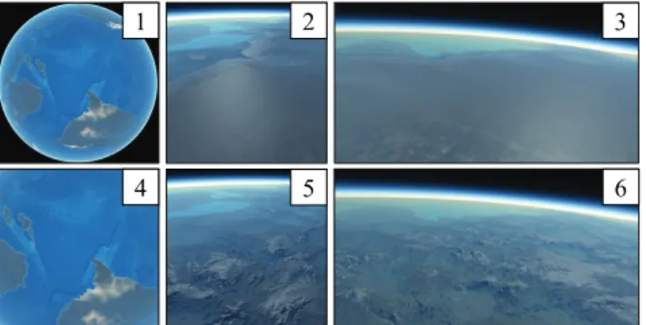
1 4 2 5 3 6
Figure 1: Our method creates planets (1) with continents, peninsu-las, island arcs, oceanic ridges and trenches (4) by computing the plate tectonics. The detailed relief (5, 6) of the planet is generated by amplifying the coarse crust model (2, 3) with landforms.
We propose instead a geologically-inspired procedural genera-tion model that approximates the deformagenera-tion of the crust under tectonic forces to obtain realistic continents and oceans (Figure1). The user can freely prescribe or change the movement of the plates at any time, or even cut plates into new fragments. Converging and diverging plates result in different phenomena including col-lision, subduction, rifting and oceanic crust generation, which are computed at interactive rates, thus allowing authoring and designer-oriented control.
Our method meets the entertainment industries need for auto-matic generation of planets, with a direct application for movies
and emerging universe-exploration games. We do not claim to re-produce the complexity of geological models or physically-based simulations [BY10], instead we provide an interactive framework for intuitively controlling the creation of realistic planets in com-puter graphics.
Tectonic plates drift, collide and deform, and we approximate tectonic effects in the lithosphere to compute the uplift and folding of the crust. Simultaneously, we adjust elevations by approximating continental erosion and taking into account oceanic crust damping due to aging and increase of density. This enables us to generate large scale mountain ranges or oceanic trenches at the boundaries of converging plates, and oceanic ridges between diverging plates. The coarse crust model is finally amplified using either real-world elevation data or procedural landforms to generate a high resolution representation of the relief according to the characteristics of the plates. The user may control the amplification process according to the characteristics of the crust; therefore our method allows for user authoring at both global and local scales.
Our main contribution is an efficient procedural model for syn-thesizing planets based on tectonics. Moreover, our method pro-vides the user with different means for controlling the evolution of the planet and prescribing the location of continents, mountain ranges or the generation of islands arcs and seas. We also demon-strate that our method lends itself for amplification, which enables us to generate detailed reliefs from the coarse scale crust param-eters obtained from the simulation. Our model can be seamlessly streamed with existing terrain amplification techniques including procedural generation [EMP∗98], sparse modeling [GDGP16], and erosion simulation [CGG∗17].
Our procedural model provides a consistent framework for au-thoring realistic tectonic planets with consistent continental and oceanic landforms. The user may pause the simulation at any time, prescribe new continent directions or change the other parameters of the plates and resume the simulation. Our experiments demon-strate that complex planets can be modeled in a few minutes. The crust model has a resolution ranging from 50 km to 500 km. The amplification process taking into account the characteristics of the crust allows us to generate detailed reliefs with a ≈ 100 m reso-lution. The shape of the continents, oceanic trenches and ridges, were validated by a geophysics expert and the realism confirmed by a user-study.
2. Related Work
A wide variety of methods for modeling terrains have been pro-posed, which can be organised into three categories: procedural generation, erosion simulation and synthesis from examples. In contrast, the generation of planets has received less attention. Procedural methods usually rely on multi-frequency noise func-tions [EMP∗98] to define elevation functions that capture the self-similarity of landforms across a range of scales and resemble real terrains. An alternative approach consists in using modified proce-dural subdivision algorithms [KMN88,PH93,BA05] to generate fractal terrains constrained by user-prescribed river trajectories.
User control of noise and fractal-based methods has been
ad-dressed by defining terrains from feature curves such as river net-works or ridges [HGA∗10,GGG∗13]. Genevaux et al. [GGP∗15] introduced a hierarchical distribution tree that models the terrain as a distribution of primitives that are procedurally blended, carved, and warped together.
Although these core algorithms can generate near infinite land-scapes with unlimited precision, they only provide indirect global control and produce terrains without any underlying geomorpho-logical structure.
Examplar-based techniques take inspiration from texture synthe-sis and aim at generating terrains that reproduce landforms ex-tracted from exemplars. Most techniques proceed by assembling patches [ZSTR07,TGM12], grid cells [GMM15] or radial primi-tives [GDGP16]. Control is often provided by some form of user sketching. Zhou et al. [ZSTR07] choose patches from an exem-plar terrain, guided by user-specified curvilinear features, and stitch them together using graph cuts and Poisson blending. Further im-provements in terms of computational efficiency and user-control were proposed by Tasse and Gain [TGM12,GMM15].
A larger-scale approach based on sparse modeling was proposed by Guerin et al. [GDGP16] where a dictionary of feature-rich radial primitives are placed and blended together to form a terrain. Gener-ative adversarial networks were used [GDG∗17] to learn and apply a correspondence between user sketch maps and scanned terrains. Those methods are fast, controllable and locally realistic but do not synthesize large-scale geomorphological patterns such as drainage networks, and do not scale to planets.
Erosion simulations approximate the different weathering phe-nomena that sculpt and shape terrains. Thermal and hydraulic ero-sion were first presented by Musgrave et al. [MKM89]. Subsurface strata play an important part in such simulations, and the differ-ent materials are encoded as a cell-based grid of layered stacks, with different thicknesses and material properties for the layers of each cell-specific stack [CGG∗17], or volumetric models [RPP93]. Closer to our research, Cordonnier et al. [CBC∗16,CCB∗18] re-cently proposed to approximate the lithosphere tectonics to repro-duce folding and faulting effects in the crust, combined with hy-draulic erosion to generate realistic mountain ranges.
While simulations produce geologically correct models, most erosion methods suffer from a high computational cost, which pre-vents direct scaling to compute the elevation of the crust of planets, and do not provide sufficient control to express the user intent. Modeling planets remains a challenging research area that has not attracted as much attention as terrain modeling in the computer graphics community. Fractal models relying on a combination of procedural noises [EMP∗98] are compact, computationally effi-cient and scale well to planets. Those representations exacerbate the problems found in fractal modeling however: self-similarity, lack of distinctive geomorphological structures and lack of con-trol. An enhanced mid-point displacement technique was proposed by Derzapf et al. [DGGK11] to generate hydrographic networks across a planet. While the generated continents are enhanced by the river networks, the reliefs still lack geological consistency as
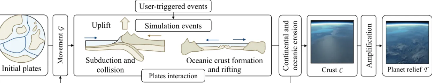
Initial plates Subduction and collision User-triggered events Planet relief T Crust C Amp lif icatio n Cont ine nt al a nd oc ea ni c e ros ion Plates interaction
Oceanic crust formation and rifting
M
ovem
ent
G Uplift Simulation events
Figure 2: Given an inital planet with plates P(0), we compute the movement of the tectonic plates P(t) and process the tectonic events such as subduction, collision or oceanic crust formation, which shape the crustC. The user can freely prescribe the geodetic movement of the platesG at any time, trigger events such as plates rifting into fragments, allowing for real-time authoring and control during the simulation. The final high resolution reliefT is obtained by amplifying the crust using either real-world elevation data or procedural landforms.
the method relies on a random walk to define the shape of the con-tinents. Moreover, the method does not allow the user to control the shape of the continents.
3. Overview
We propose a procedural approach inspired from tectonics for mov-ing, deformmov-ing, colliding plates and generating continents and the complex relief resulting from the interaction of plates. We approxi-mate the tectonics phenomena (Figure3) to generate a coarse scale representation of the lithosphere. This representation is then ampli-fied to obtain a detailed and coherent relief over the surface of the planet (Figure2).
Seafloor generation
Subduction Plate rifting
Continental collision
Figure 3: Examples of the four major tectonic phenomena repro-duced in our procedural model: subduction, continental collision, seafloor generation and plate rifting.
Tectonics fundamentals Plates form a partition of the lithosphere, the uppermost layer of the planet. As the lithosphere is colder and less dense than the asthenosphere, plates can be seen as rigid frag-ments or slabs, floating and drifting above the mantle. The crust, which is the upper part of the lithosphere, can be either oceanic or continental, the latter being older, less dense and thicker than the former. As plates drift across the surface of the sphere they sepa-rate, collide an deform along their boundaries and shape the crust, hence the relief of the surface of the planet.
Model Our procedural model relies on heuristics chosen for their performance and plausibility (Section4). The reason for this is im-parted by research in plate tectonics which is mostly a qualitative
theory. No direct formulae exist for evaluating plate deformation and uplift movement. While quantitative tectonophysics models have emerged recently, they rely on partial differential equations that require computationally expensive numerical solvers. As such they do not provide a direct or closed form expression of the phe-nomena occurring at the surface of the planet. Instead, we propose a novel phenomenological model designed to reproduce the behav-ior of plate tectonics phenomena, yet without guaranteed physical accuracy.
Structure and movement Plate parameters Plate P c w ω s(c) z e(p) p 0 Elevation Terranes R Plate border Continental Oceanic Crust C
Figure 4: Parameters of a tectonic plate: crust C, elevation z and thickness e, geodetic movementG.
A planet is defined as a set of tectonic plates, denoted as P (Figure4). Without loss of generality, we assume that a planet is a sphere centered at the origin; the slightly oblate shape of some planet is not taken into account out of efficiency and can be ob-tained as a post processing step by warping the crust.
Symbol Description
xC Crust type (oceanic or continental)
e Crust thickness
z Relief elevation
ao Crust age (oceanic)
r Local ridge direction (oceanic) ac Orogeny age (continental)
o Orogeny type (continental) f Local fold direction (continental) Table 1: Parametrization of the crust.
Each plate P is a portion of crust parametrized (Table1) over its domain with the following functions: type xC(p), thickness e(p) and surface elevation z(p). According to the crust type xC, which can be either oceanic or continental, we add the following param-eters: crust age ao(p), local ridge direction r(p), for oceanic crust - and orogeny type o(p), local fold direction f(p) and orogeny age ac(p) for continental crust. The age of oceanic crust represents its age since the formation along the oceanic ridge. The orogeny type of continents can be either Andean or Himalayan, i.e. , the result of subduction or continental collision respectively. These parameters are involved in the simulation of the evolution of the planet, and are also used for the reconstruction of the detailed relief of the planet during the amplification process. AppendixApresents a table with notations and constants used in our model.
In our implementation, plates are modeled as spherical triangu-lations M of points pk. The points sample the surface of the planet and store the crustal and tectonic data and the functions are defined using barycentric interpolation.
The plates are moving over the reference sphere according to a rigid geodetic movement, denoted as G. As described in geoscience, the rotational movement of the plates is defined by using a normal-ized rotation axis w passing through the center of the planet. Let ω the angular speed, the surface speed of any point p on a plate is defined as s(p) = ω w × p.
Terranesare an important concept in our model. In geology, they are portions of continental crust or island systems transported by surrounding oceanic crust to subduction zones. They resist subduc-tion and instead suture or accrete to the base continental plate. In our model, we simplify and extend this definition: a terrane R in a plate P will be defined as a connected region of continental crust (Figure4). Therefore, terranes can range in size from small isolated islands to entire continents.
Workflow An interactive authoring session (Figure2) starts with the specification of the initial state of the plates Pi which can be shaped by the user, or generated procedurally. In our implementa-tion, this automated generation is performed by distributing a user-prescribed number of plate centroids ciover the sphere and defin-ing the plates as the spherical Voronoi cells of the set {ci}. More irregular continent shapes can be obtained by warping the geodetic distances to the centroids using a simple noise function. We then initialize the movement of the plates Gi, which can be also defined by the user or randomly generated.
The simulation computes the interactions between the plates such as subduction, collision, oceanic crust formation and rifting (Figure3), and updates the characteristics of the crust C. All these phenomena can be also triggered or parametrized by the user at any time during the evolution, allowing direct and interactive con-trol. The detailed high resolution relief of the planet T can then be generated by amplifying the crust data using either procedural amplification or synthesis from example data.
4. Procedural tectonics
The overall tectonic simulation computes the evolution of the char-acteristics of the crust according to the interaction between the
drifting tectonic plates. The iterative process is based on a discrete time-step δt set to 2 My in our implementation.
The simulation computes the interactions between the plates. We model four different types of interactions: subduction (Section4.1) and continental collision (Section 4.2) which both take place at convergent boundaries, oceanic crust generation (Section4.3) that takes place at divergent plate boundaries, and plate rifting which is the fragmentation of a plate into smaller plates (Section4.4), that tend to drift apart from each other. We compute the interpenetration distance between colliding plates and the distance to the oceanic ridge to update the parameters of the plates such as fold directions f, surface elevations z, or crust age ao. The crust elevations are then modified according to continental erosion and oceanic crust eleva-tion dampening (Seceleva-tion4.5).
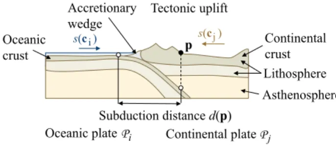
4.1. Subduction
Classic subduction (Figure5) occurs at the convergent boundary between an oceanic plate Pi and a second plate Pj, which can be either continental or oceanic. The density of the crust of plate Piis greater than Pj, which causes Pito plunge beneath Pj: the slab is sucked into the mantle, and at the subduction front a deep oceanic trenchforms. Subduction generates volcanism and defor-mation (orogeny) of the overriding plate.
Our model also simulates so-called forced subductions, taking place where high oceanic relief (plateaus, old ridges) or small ter-ranes (islands) that are part of the subduction system are forced under another plate. This type of subduction yields greater defor-mation of the overriding plate Pj[Clo93,DLMvH98].
Subduction distance d(p) Continental plate Oceanic plate Oceanic crust Lithosphere s(c )i s(c )j Asthenosphere Tectonic uplift Accretionary wedge Continental crust Pj Pi p
Figure 5: Oceanic-continental subduction: the oceanic plate Pi plunges down and the crust of the continental platePj folds and deforms in a global uplift.
We trigger a subduction event according to the relative size and age of the plates in contact. Two converging oceanic plates always lead to the subduction of the older plate. An oceanic plate always plunges beneath a continental plate. Finally, we allow partial sub-duction when we find a continental-continental configuration; this initiates a forced subduction, which then evolves into a continental collisionwhere terranes collide.
We compute the uplift in the subduction region between the two plates. Let p a point of plate Pj in the subduction region, and d(p) the distance to the subduction boundary (Figure5). Let v(p) = ksi(p) − sj(p)k denote the relative speed of the two plates.
We define the upliftuejof plate Pjas a combination of the relative speed v, the distance to the subduction front d and the elevation of the plate Piplunging beneath Pj(Figure6):
e
uj(p) = u0 f◦ d(p) g ◦ v(p) h ◦ezi(p)
u0is the base subduction uplift (SectionA). The functions f and
Distance transfer f (d) 1 d 0 g (v) 1 v 0 1 h (z ) 1 z 0
Speed transfer Height transfer ~ ~
v0 rs
Figure 6: Uplift subduction profile curves: f taking into account the distance to the front, g taking into account the relative speed, and h for elevation.
gdefine the normalized deformation with respect to the distance to the subduction front d(p) and the relative speed v(p). In our imple-mentation, f is defined as a piecewise cubic curve with a maximum at a control distance to the boundary, that fades to 0 when the dis-tance reaches the maximum subduction disdis-tance. g is defined as a simple linearly increasing function g(v) = v/v0.
Letez(p) denote the normalized elevation with respect to the max-imum depth of oceanic trenches ztand the highest continental ele-vation zc. The influence of the elevation of the crust Piis:
h(ezi) =ez 2
i ezi(p) = (zi(p) − zt)/(zc− zt)
The concept is that, as mentioned, elevations above sea level have an important impact over the uplift, whereas abyssal elevations do not play an important part. In practice, the relative influence of the deformation functions can be controlled by user-defined weights.
We set the orogeny age of the emerging parts of islands or con-tinents ac(t + δt) = 0. The new elevation of the crust of plate Pjis defined as:
zj(p,t + δt) = zj(p,t) +uej(p) δt
We update the fold direction according to the relative speed of the plates:
fj(p,t + δt) = fj(p,t) + β(si(p) − sj(p)) δt
β is a constant weighting the influence of the relative speed over the folding direction.
Slab pull is a specific phenomenon that takes place at the sub-duction front for parts of the crust that start the subsub-duction process. Slab pullrefers to the fact that any subducting plate is always drawn towards its subduction front. To take this phenomenon into account, we update the geodetic movement Giof the plate Piby modifying its rotation axis:
wi(t + δt) = wi(t) + ε n−1
∑
k=0 ci× qk ||ci× qk|| δtThe points qkare located in the subduction front. This transforma-tion brings the plate Picloser to the local subduction front.
The modification of the rotation axis are scaled according to the parameter ε; we use ε 1 so that a single sample point will have a limited influence over the movement of the plate, whereas long subduction fronts with many points samples will have a noticeable influence.
4.2. Continental collision
The convergence of two plates with sufficient continental mass may result in a continental collision. The density of the continental crust does not allow subduction, therefore a slab break event occurs, i.e. the rupture of the terranes from their supporting plate, and the su-turing of the colliding continental parts with the collided plate.
s(c )i R Collision region Continental plate Pj Pi Oceanic plate s(c )j q Uplift influence R R ⊕ B (r) p d(p,R) r
Figure 7: Collision between an oceanic plate Piand a continental platePj: a small terrane detaches fromPi, merges withPj and produces a local uplift in its neighborhood.
Without loss of generality, let Pian oceanic plate with one ter-rane R and Pja continental plate (Figure7). Contrary to subduc-tion, which is a continuous process extending over many time steps, collisions are discrete events: at a given time step t the terrane R stops migrating and sutures to the collided plate Pj. The region of influence of the collision is defined as R ⊕ B(r), i.e. the area of the terrane offset by a radius r representing the maximum distance of influence. Let q the centroid of R, the radius of influence should be greater as the area of the terrane A is larger and as the relative speed of the plates increases. We use the following power law:
r= rc p
v(q)/v0A/A0
The constant rcrepresents the global maximum influence distance for the model; A0is a constant representing the average initial area of a tectonic plate.The discrete elevation surge ∆z in the neighbor-hood of R is defined as a compactly supported function of the dis-tance to the terrane:
∆z(p) = ∆cA f ◦ d(p, R) f(x) = (1 − (x r)
2 )2 where ∆cdenotes the discrete collision coefficient (AppendixA). Finally, the elevation of p is instantly augmented:
z(p,t + δt) = z(p,t) + ∆z(p) The new local folding direction is given by :
f(p,t + δt) = (n × p − q ||p − q||) × n
where n is the normal to the sphere at p and q is the centroid of the terranes. Once the data of the points have been updated for plate Pj, we detach the samples in R and attach them to plate Pj.
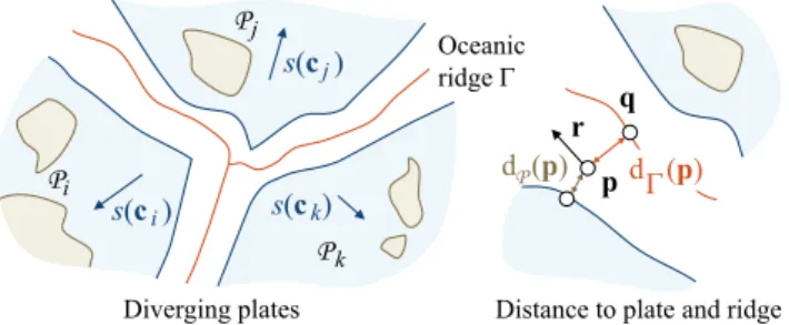
4.3. Oceanic crust generation
The oceanic crust forms from the ridge separating diverging plates. As oceanic crust ages, it gets colder and denser and tends to lower its elevation, forming abyssal plains.
Pi Pj Pk Oceanic ridge Γ s(c )j s(c )k s(c )i p d (Pp) d (Γ p)
Diverging plates Distance to plate and ridge q
r
Figure 8: Oceanic crust generation between diverging plates.
Let dΓ(p) and dP(p) the distances from p to the ridge and to the closest plate respectively (Figure8). We define the interpolat-ing factor as α = dΓ(p)/(dΓ(p) + dP(p)). The elevation of the new points z(p,t) is computed by blending the linearly interpolated el-evation between plates ¯z with a template ridge function profile zΓ (Figure9):
z(p,t + δt) = α ¯z(p,t) + (1 − α) zΓ(p,t)
We compute the direction parallel to the ridge r which is used for amplifying the oceanic crust and to generate the detailed oceanic terrain model. Let q the projection of p onto the ridge, we define:
r(p) = (p − q) × p Interpolated crust border elevation z Ridge Γ s(c )i q α p s(c )j Γ z(p) Plate Pi Plate P j Crust elevation Template ridge profile z z(p) z (p)Γ
Figure 9: Computation of the oceanic crust elevation along oceanic ridges: z(p) is defined by blending a generic profile curve zΓwith the interpolated elevation¯z.
Plate sampling During the oceanic crust generation, we generate new points in the region of the ocean ridge, assign them to the nearest plate, and compute their corresponding crust parameters. Oceanic crust formation is a continuous process that extends over several time steps. However, because of the sampling and meshing process involved in the computation of the plates, the oceanic crust generation is processed every 10 − 60 time steps, depending on the observed maximum plate speed.
4.4. Plate Rifting
Plate rifting is a discrete event which fragments a plate into smaller plates, which in turn tend to drift apart from each other (Figure10). It plays an important part in the overall realism of a virtual planet as it prevents the formation of unnatural super-continents caused by collisions.
Rifting fractures a given plate P into n sub-plates Pi, n ∈ [2, 4]. The fracture curve Γ and the shape of the new sub-plates are com-puted by distributing n centroids ci at random positions in P and constructing corresponding Voronoi cells Pi. We warp the bound-aries of the Voronoi cells to generate irregular fracture lines be-tween the sub-plates. Random diverging directions are finally as-signed to the new plates.
Rifting events are triggered according to a Poisson Law proba-bility whose parameter λ accounts for the relative continent size:
P= λ e−λ with λ = λ0f(xP) A/A0
where λ0defines the average number of rifting events in the con-sidered time window, and the transfer function f (xP) defines the influence of the continental crust type ratio of the plate xP.
Fracture Separated plates
Figure 10: Example of a plate rifting into 2 fragments: left im-age shows the plate before fragmentation, right imim-age shows two separated continents after15 My.
Note that rifting events can be triggered and controlled by the user by prescribing the location, the fracture line Γ and the time step at which the event takes place.
4.5. Continental erosion and oceanic dampening
At every time step of the simulation we perform continental erosion and oceanic dampening that modify the elevation of crust samples. Continental erosion The relief of continents is shaped by a vast variety of erosion phenomena such as hydraulic, thermal, glacial or wind erosion. The coarse sampling resolution of the crust (≈ 50 km) combined with the large time steps (2 My) allow us to rely on a simple erosion model. In our approach, we perform the fol-lowing simple erosion:
z(p,t + δt) = z(p,t) −z(p,t) zc εcδt
Oceanic dampening As the oceanic crust spreads from the mid-ocean ridge and ages, its density increases and its elevation de-creases. We apply the following dampening:
z(p,t + δt) = z(p,t) − (1 −z(p,t) zt
Moreover, oceanic trenches tend to be filled with sediments, mostly imparted by the formation of an accretion wedge at the subduction front. Therefore, we approximate the sediment filling process by modifying the elevation of the point samples in the trenches:
z(p,t + δt) = z(p,t) + εtδt
The three constants εc, εoand εtrepresent the continental erosion, the oceanic elevation damping and the sediment accretion values for the simulation (AppendixA). Finally we apply low frequency coherent noise to obtain more realistic variations over the planet.
5. Amplification
Once terminated by the user, the tectonics process yields crust data C. This coarse model can be further amplified to obtain the final terrain T of the planet. We extract relevant information from the sampled crust data, and transfer it to the relief generator. In this section, we describe two generators: one purely procedural, and another exemplar-based.
Oceanic trench Oceanic ridge
Figure 11: Procedural amplification of the oceanic crust obtained by adding noise with amplitudes and frequencies computed from the age and ridge direction parameters; small islands have been generated by the tectonic process.
Procedural amplification is performed by adding coherent noise to the base crust elevation z. This technique is used to generate the oceanic relief (Figure11). Mid-ocean ridges are characterized by many transform faults, lying perpendicular to the ridges. We re-create this feature by using 3D Gabor noise [LLDD09], oriented using the recorded parameters r, i.e. the local direction parallel to the ridge, and oceanic crust age aoto accentuate the faults where the crust is young. We add, as an extra layer, a high frequency gra-dient noise sum to provide details for underwater sceneries. Exemplar-based generation relies on blending heightfield primi-tives [GGP∗15] to synthesize the elevation of the terrain T . The heightfield primitives can be real earth elevation data or user-specified elevation models. Recall that the crust C is described as a set of samples, each holding data recorded from the procedural tectonics process. We identify the local terrain type xT, and then assign a primitive matching it to every sample point (Figure12).
Our implementation uses exemplar-based terrains for generating the continental relief. We used some of the USGS Shuttle Radar Topography Mission digital elevation models, at 90 m precision. Each exemplar E was preprocessed to extract its average folding direction fE and the elevation range. Continental point samples in C falling in an orogeny zone are assigned specific xT depending on the recorded endogenous factor o, i.e. subduction or continental
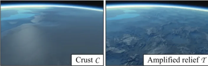
Crust C Amplified relief T
Figure 12: Example of crust C terrain generated by the simula-tion (left) and the detailed elevated reliefT (right) obtained by exemplar-based amplification.
collision. The resulting terrain type is either Andean or Himalayan. If the local age of the orogeny is superior to a user-specified thresh-old, then xT is set to old mountains. If the continental sample falls outside any orogeny, xT is set to plain.
The positions of the primitives are shifted by a small random off-set to avoid repetition artifacts, and rotated in the tangent plane of the sphere to align with the local fold direction f. The final ampli-fied elevation is computed as a weighted sum of the elevation of the primitives.
6. Implementation Details
The crust is initialized as a set of attributed points p over the sphere. To generate a near-optimal distribution of the sample points, we rely on Fibonacci sampling of the sphere [KISS15]. We then con-struct a global Spherical Delaunay Triangulation [Ren97], that we partition into a set of initial plates P.
Meshing The sampling and meshing of the sphere is performed off-line as a pre-processing step, and re-used many times during the simulation, in particular for seafloor generation. Instead of incre-mentally remeshing the planet at every step, which would be com-putationally demanding, we compute the movement of the plates and perform a global resampling every 10 − 60 iterations. The pa-rameters of the samples located between diverging plates are com-puted using the method described in Section4.3. The parameters of the other sample points are computed using barycentric inter-polation of crust data from the plate they intersect. The new set of plates is built by partitioning the triangulation according to samples assignments.
Plate boundary tracking We detect plate collisions efficiently by tracking the intersection between the boundary triangles of the plates. We also rely on a bounding box hierarchy for every plate to accelerate intersection tests. For each tracked converging tri-angle, we also update the distance of its vertices to the conver-gence front at every time step by overestimating: d(p,t + δt) ≥ d(p,t) + ||s(p)||δt.
Continental collisions Terranes are handled while tracking plate subduction. If two continental triangles of two different plates in-tersect, we switch the tracking mode to continental collision. The collision event is triggered if the interpenetration distance between the two plates is greater than a user-defined threshold, 300 km in
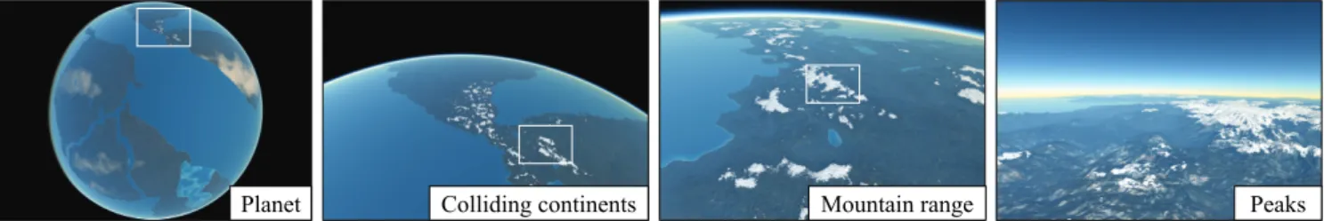
Planet Colliding continents Mountain range Peaks Figure 13: Real time rendering of a synthetic planet with four visible continents: the low resolution model of the crust is amplified with a procedurally parametrized elevation model to obtain high resolution terrains, thus allowing for real time authoring.
our system. For a given plate Pi, the set of terranes and the set of collided plates are detected. We detach each terrane by removing its triangles indexes and attach them to the collided plate. Finally, we compute and spread the uplift in the collision region.
7. Results
Our method was implemented in C++ and tested on an Intel Core i7 − 6700 K clocked at 4 GHz with 16 GB of RAM and a Nvidia GTX 1080. The planets shown throughout the paper were gener-ated using our tectonics-inspired algorithm. We relied on the graph-ics hardware for real-time rendering. Our implementation achieves a frame rate ranging between 37 and 145Hz, depending on camera altitude. An adaptive meshing scheme is used, the ocean surface exists as an animated mesh and the oceanic and atmospheric ren-dering are implemented as shaders. A complete description of the rendering technique is beyond the scope of the paper, we refer the reader to [CR11] for an introduction to planet-scale rendering.
All the images shown throughout the paper show a variety of synthetic planets that have been generated by our approach. Unless stated otherwise, we used 500 000 point samples for the tecton-ics model for a 6 370 km radius planet (≈ 35 km resolution). The example-based amplification process used 19 sets taken from the publicly available USGS data set STRM90: 7 for young Himalayan regions, 11 for Andean orogeny, and 6 for old mountain ranges.
7.1. Control
The originality of our approach consists in combining a procedural model for approximating and simulating the complex tectonic phe-nomena with the ability to interactively change the parameters of the plates during the simulation.
As a purely procedural approach, our method can generate a time-varying synthetic planet. Given an initial continental and oceanic plate distribution and geodetic movements, our procedural model computes their evolution and can automatically synthesize a virtual planet featuring important emerging characteristics such as oceanic ridges and plains, and continental plains and mountain ranges. Our experiments show that realistic planets are obtained af-ter a few hundreds iaf-teration, i.e. ≈ 250My.
The user can chose to design the initial tectonic plates and con-trol scenarios (Figure16) for its temporal evolution by prescrib-ing the geodetic movements of the plates, or start from an existprescrib-ing
planet such as the earth and synthesize scenic events, for example the rifting of the African continent, and making Australia collide with Asia (Figure17). Our method is not physically accurate and will not predict the true evolution of the Earth, however it provides user-control and is sufficiently plausible for the production of spe-cial effects and science fiction scenarios.
Alternatively, the user may also control the procedural genera-tion of plates by prescribing global constraints, such as the initial continental to oceanic ratio or the initial number of plates. At any moment during the simulation the user can select continents, adjust the movements or directly change the parameters of the crust. The user may also trigger rifting events on continents and define the way a plate should split, or switch the main crust type, e.g. from continental to oceanic.
7.2. Comparison to other methods
Although a variety of methods for modeling and generating vir-tual terrains and landscapes have been proposed, few attempts have been made to synthesize entire planets. Existing techniques rely on procedural noise [EMP∗98] or modified mid-point displace-ment [DGGK11].
Tectonic plates Noise-based planet
Figure 14: Comparison between a planet generated by using a sum of noise, and our method. Noise-based planets have homoge-neous fractal shaped continents and highly varying oceanic crust elevation, and mountain ranges are located at the center of the con-tinents. In contrast, our method produces distinctive and realistic oceanic and continental landforms featuring continental symmetry, coastal cordilleras, and oceanic trenches.
330 My 340 My 355 My 370 My Figure 15: Example of a terrane accreting onto a continent. At t = 330 My, the oceanic plate to the east converges towards the continental plate, and initiates subduction; uplift induces seafloor elevation, producing the emergence of an island arc. At t= 340 My the island arc has turned into a large island, oriented along the subduction front and its trench. At t= 355 My the user re-orients the movement of the oceanic plate to the north-west, and the collision at t= 370 My produces the complete accretion of the island to the main continent.
Fractal approaches put the emphasis on self-similarity, and there-fore fail at generating characteristic landforms structures, both in terms of shape and distribution, such as groups of islands near a continent, or cordilleras close to coastlines. Figure14 shows a side by side comparison of a noise-based synthetic planet and our tectonics-based model. Note that although our current implemen-tation does not generate drainage networks over the continents, our plate model is compatible with existing river network gener-ation [DGGK11] and stream power erosion algorithms [CBC∗16] which could be used to better sculpt the coarse crust elevations (see Section7.5about limitations), at the expense of more computation-ally demanding iterations.
7.3. Validation
We performed a user study to evaluate the realism of synthetic plan-ets produced by our tectonics-based method compared to existing fractal-based approaches [EMP∗98]. We chose to compare results using a two-alternative forced choice user experiment. Participants in the study were presented with 6 pairs of images, and asked to select the most realistic in each case. The overall order of presenta-tion, as well as the order within pairs, was randomized. In this ex-periment, the shading of the two planets was identical (Figure14), in order to avoid any bias induced by the rendering. 24 persons, between the age of 22 and 28, participated in the study. Our model received a total of 97 votes, compared to 47 for the fractal model. This yields to a χ2of 8.3 and a p-value less than 0.4%, which is highly in the favor of our method.
A more complete user study could be carried out to evaluate the visual impact of the individual components and parameters of our model, such as relative percentage of continents, or drifting param-eters. Although time consuming, such a study would be an interest-ing extension for future work. We validated the result of our sim-ulation with a geological expert in tectonics. The expert was very positive about the overall realism of the animated virtual planets (see accompanying video) and confirmed that the effects produced by our procedural model were realistic. He pointed out several mi-nor defects that should be taken into account to improve the method (see Section7.5on limitations).
7.4. Performance
The geometric model computation is split into two parts. The crust computation is performed on the CPU and the crust data, including the indexes of the exemplars, base elevations, age and fold direc-tions, are streamed to the GPU. The amplification process is per-formed directly on the GPU.
Resolution 102 km 78 km 50 km 35 km Sample points 60k 100k 250k 500k Subduction 0.08 0.14 0.26 0.65 Continental collision 0.02 0.04 0.69 0.63 Elevation 0.09 0.10 0.29 0.62 Total 0.19 0.28 1.24 1.90 Oceanic crust 0.58 1.22 3.58 13.10 Plate rifting 0.23 0.21 1.50 7.70
Table 2: Average time-step execution time (in seconds) for different planet resolutions; the planet has a6 370 km radius.
Table2reports crust generation statistics for a planet with an initial state featuring 40 plates and a land coverage ratio of 0.3. Oceanic crust generation and plate rifting are the most computa-tionally demanding tectonic processes, whereas the other ones can be computed at interactive rates for a resolution of ≈ 100 km. In our implementation, we perform plate rifting and crust generation every 20 to 120 My, depending on maximum plate speed.
The computation of the elevation of the crust is performed in parallel over several threads: the tectonic processes which are per-sample point atomic operations can be safely threaded. The trian-gulation M of the continental and oceanic plates is organized into a bounding box hierarchy to speed up the intersection tests and the distance queries.
7.5. Limitations and future work
Control. In our current implementation, the user can only control the movement and fracture of the plates throughout time. There-fore, she only has indirect control over the final shape of the con-tinents and the characteristics of the oceanic and continental relief. This limitation could be leveraged by combining our method with
36 My 77 My 108 My 182 My 191 My 245 My Figure 16: Example of a user-defined scenario defining the evolution of the continents of a planet. At t = 36 My, the user modified the geodetic movement of the oceanic plate containing the island to the east, so that it should move towards the continent and collision occurs at t= 77 My. At t = 108 My the northern continent accelerates towards the center, subduction is initiated at t = 182 My involving the oceanic border of both plates. Subduction turns into collision of the plates due to massive continental crust at191 My. Finally, the user selected the newly formed super-continent and triggered a plate rifting event which resulted in a fracture and the apparition of a new sea, at t= 245 My.
other smaller-scale terrain authoring systems to provide more con-trol over the generated planets.
Realism. Although we had to simplify some phenomena in order to obtain a procedural model allowing for interactive control, our approach was validated by a geological expert in tectonics who pointed out several limitations. Here we review some of the lim-itations and propose interesting research directions.
Plate rifting progressively tears the crust into pieces instead of directly breaking the crust; the very reason for that is that the ro-tation axes of the fragments are located at a point along the rift. In our implementation we resorted to direct divergence of the frag-ments to avoid any collision artifacts between neighboring plate boundaries, which would have sutured the fragments and therefore canceled the rifting process. A more precise boundary tracking al-gorithm would enable us to better reproduce the tearing effect effi-ciently. Our plate convergence model tends to generate more forced subductionevents than expected. The reason comes from efficiency concerns as detecting and preventing subduction of large terranes would introduce another computationally demanding step in the simulation loop; we preferred preserving the interactive speed of our model to allow authoring.
For similar efficiency reasons, we did not model passive margins and more generally shallow underwater continental parts. Finally, we did not generate hot spots in our model, such as the Hawaiian is-lands chain. This feature could be easily implemented in our model as specific sample points drifting across plates.
8. Conclusion
In this paper, we have presented an original tectonic-inspired pro-cedural approach for modeling virtual planets. Our approach al-lows to control the shape of the continents and generates coherent continental and oceanic landforms such as mountainous cordilleras and plateaus, oceanic ridges and island arcs. Our method provides global and local control to the user who may prescribe the move-ment of the continents, or trigger events such as rifting interactively during the simulation. The data produced by the crust simulation provides us with landform parameters which can be used to am-plify the elevation of the crust and generate high resolution terrain reliefs.
Figure 17: Example of a user-specified evolution of the earth: the plates were initialized with elevation data, and the user defined the movement of the plates. At80 My, the continents had drifted or collided, but the original landforms were still recognizable.
This original work is a first step towards procedural modeling of planets and opens several interesting research directions. The procedural tectonic model could be improved to include some spe-cific and important phenomena such as hot spots that generate vol-canic islands or ocean floor aging which creates complex oceanic trenches. Finally, our model could be combined with a procedural atmosphere and climate model at different time scales to allow the simulation of large scale ecosystems.
Acknowledgments This work was supported by the project PA-PAYA P110720-2659260, funded by the Fonds National pour la So-ciété Numérique and the project HDW ANR-16-CE33-0001. Spe-cial thanks go to Nicolas Coltice (Laboratoire of Geology of Ecole Normale Supérieure de Paris) for having helped us to improve the method and to evaluate the results.
References
[BA05] BELHADJF., AUDIBERTP.: Modeling landscapes with ridges and rivers. In Proceedings of the Symposium on Virtual Reality Software and Technology(Monterey, USA, 2005), ACM, pp. 151–154.2
genera-tion of plate tectonics from mantle dynamics. Treatise on Geophysics. Elsevier, Oxford(2015), 271–318.1
[BY10] BRAUN J., YAMATO P.: Structural evolution of a three-dimensional, finite-width crustal wedge. Tectonophysics 484(2010), 181–19.2
[CBC∗16] CORDONNIERG., BRAUNJ., CANIM.-P., BENESB., ÉRIC GALIN, PEYTAVIEA., ÉRICGUÉRIN: Large scale terrain generation from tectonic uplift and fluvial erosion. Computer Graphics Forum 35, 2 (2016), 165–175.2,9
[CCB∗18] CORDONNIER G., CANI M.-P., BENES B., BRAUN J., GALINE.: Sculpting mountains: Interactive terrain modeling based on subsurface geology. IEEE Transactions on Visualization and Computer Graphics 24, 5 (2018), 1756–1769.2
[CGG∗17] CORDONNIERG., GALINE., GAINJ., BENESB., GUÉRIN
E., PEYTAVIE A., CANI M.-P.: Authoring Landscapes by Combin-ing Ecosystem and Terrain Erosion Simulation. ACM Transactions on Graphics 36, 4 (2017), 134:1–134:12.2
[CGU17] COLTICEN., GÉRAULTM., ULVROVÁM.: A mantle convec-tion perspective on global tectonics. Earth-science reviews 165 (2017), 120–150.1
[Clo93] CLOOSM.: Lithospheric buoyancy and collisional orogenesis: Subduction of oceanic plateaus, continental margins, island arcs, spread-ing ridges, and seamounts. Geological Society of America Bulletin 105, 6 (1993), 715–737.4
[CR11] COZZIP., RINGK.: 3D engine design for virtual globes. AK Peters/CRC Press, 2011.8
[CS17] COLTICEN., SHEPHARDG. E.: Tectonic predictions with man-tle convection models. Geophysical Journal International 213, 1 (2017), 16–29.1
[DGGK11] DERZAPFE., GANSTERB., GUTHEM., KLEINR.: River networks for instant procedural planets. Computer Graphics Forum 30, 7 (2011), 2031–2040.2,8,9
[DLMvH98] DOMINGUEZS., LALLEMANDS., MALAVIEILLEJ.,VON
HUENER.: Upper plate deformation associated with seamount subduc-tion. Tectonophysics 293, 3-4 (1998), 207–224.4
[EMP∗98] EBERTD. S., MUSGRAVEF. K., PEACHEYD., PERLINK., WORLEYS.: Texturing and Modeling: A Procedural Approach, 3rd ed. Morgan Kaufmann Publishers Inc., 1998.2,8,9
[GDG∗17] GUÉRINE., DIGNEJ., GALINE., PEYTAVIEA., WOLFC., BENESB., MARTINEZB.: Interactive example-based terrain authoring with conditional generative adversarial networks. ACM Transactions on Graphics (Proceedings of Siggraph Asia) 36, 6 (2017), 228:1–228:13.2
[GDGP16] GUÉRINE., DIGNEJ., GALINE., PEYTAVIEA.: Sparse representation of terrains for procedural modeling. Computer Graphics Forum (Proceedings of Eurographics) 35, 2 (2016), 177–187.2
[GGG∗13] GÉNEVAUXJ.-D., GALINÉ., GUÉRINÉ., PEYTAVIEA., BENESB.: Terrain generation using procedural models based on hy-drology. Transaction on Graphics 32, 4 (2013), 143:1–143:13.2
[GGP∗15] GÉNEVAUXJ.-D., GALIN É., PEYTAVIEA., GUÉRINÉ., BRIQUETC., GROSBELLETF., BENESB.: Terrain modeling from fea-ture primitives. Computer Graphics Forum (2015), 198–210.2,7
[GMM15] GAINJ., MERRYB., MARAISP.: Parallel, realistic and con-trollable terrain synthesis. Computer Graphics Forum 34, 2 (2015), 105– 116.2
[HGA∗10] HNAIDI H., GUÉRIN É., AKKOUCHE S., PEYTAVIE A., GALINÉ.: Feature based terrain generation using diffusion equation. Computer Graphics Forum 29, 7 (2010), 2179–2186.2
[KISS15] KEINERTB., INNMANNM., SÄNGERM., STAMMINGERM.: Spherical fibonacci mapping. ACM Transactions on Graphics 34 (2015), 193:1–193:7.7
[KMN88] KELLEYA. D., MALINM. C., NIELSONG. M.: Terrain sim-ulation using a model of stream erosion. SIGGRAPH Computer Graph-ics 22, 4 (1988), 263–268.2
[LLDD09] LAGAEA., LEFEBVRES., DRETTAKISG., DUTRÉP.: Pro-cedural noise using sparse gabor convolution. ACM Transactions on Graphics 28, 3 (2009), 54:1–54:10.7
[LP68] LEPICHONX.: Sea-floor spreading and continental drift. Journal of Geophysical Research 73, 12 (1968), 3661–3697.1
[MKM89] MUSGRAVEF. K., KOLBC. E., MACER. S.: The synthe-sis and rendering of eroded fractal terrains. ACM Siggraph Computer Graphics 23, 3 (1989), 41–50.2
[Mor68] MORGANW. J.: Rises, trenches, great faults, and crustal blocks. Journal of Geophysical Research 73, 6 (1968), 1959–1982.1
[PH93] PRUSINKIEWICZP., HAMMELM.: A fractal model of mountains and rivers. In Graphics Interface (1993), vol. 93, Canadian Information Processing Society, pp. 174–180.2
[Ren97] RENKAR. J.: Algorithm 772: Stripack: Delaunay triangulation and voronoi diagram on the surface of a sphere. ACM Transactions on Mathematical Software (TOMS) 23, 3 (1997), 416–434.7
[RPP93] ROUDIERP., PEROCHEB., PERRINM.: Landscapes synthesis achieved through erosion and deposition process simulation. Computer Graphics Forum 12, 3 (1993), 375–383.2
[TGM12] TASSEF. P., GAINJ. E., MARAISP.: Enhanced texture-based terrain synthesis on graphics hardware. Computer Graphics Forum 31, 6 (2012), 1959–1972.2
[ZSTR07] ZHOUH., SUNJ., TURKG., REHGJ. M.: Terrain synthesis from digital elevation models. IEEE Transactions on Visualization and Computer Graphics 13, 4 (2007), 834–848.2
Appendix A: Constants
The model is completed by a set of global parameters, with the fol-lowing values. The sea level was set to 0 as the reference elevation.
Symbol Description Value
δt Time-step 2 My
R Planet radius 6 370 km
zr Highest oceanic ridge elevation −1 km
za Abyssal plains elevation −6 km
zt Oceanic trench elevation −10 km
zc Highest continental altitude 10 km
rs Subduction distance 1 800 km
rc Collision distance 4 200 km
∆c Collision coefficient 1.3 × 10⁻⁵km−1
v0 Maximum plate speed 100 mm y−1
εo Oceanic elevation damping 4 × 10⁻²mm y−1
εc Continental erosion 3 × 10⁻²mm y−1
εt Sediment accretion 3 × 10⁻¹mm y−1
uo Subduction uplift 6 × 10⁻¹mm y−1
Table 3: Overview of the main parameters for our synthetic planet generation algorithm; the values reported in the table were used for generating the examples showed throughout the article.