Publisher’s version / Version de l'éditeur:
Vous avez des questions? Nous pouvons vous aider. Pour communiquer directement avec un auteur, consultez la première page de la revue dans laquelle son article a été publié afin de trouver ses coordonnées. Si vous n’arrivez pas à les repérer, communiquez avec nous à PublicationsArchive-ArchivesPublications@nrc-cnrc.gc.ca.
Questions? Contact the NRC Publications Archive team at
PublicationsArchive-ArchivesPublications@nrc-cnrc.gc.ca. If you wish to email the authors directly, please see the first page of the publication for their contact information.
https://publications-cnrc.canada.ca/fra/droits
L’accès à ce site Web et l’utilisation de son contenu sont assujettis aux conditions présentées dans le site
LISEZ CES CONDITIONS ATTENTIVEMENT AVANT D’UTILISER CE SITE WEB.
Canadian Geotechnical Journal, 23, 3, pp. 346-354, 1986-08
READ THESE TERMS AND CONDITIONS CAREFULLY BEFORE USING THIS WEBSITE. https://nrc-publications.canada.ca/eng/copyright
NRC Publications Archive Record / Notice des Archives des publications du CNRC : https://nrc-publications.canada.ca/eng/view/object/?id=5c61aee6-7ecd-4fe3-8f91-699d92bb5af8 https://publications-cnrc.canada.ca/fra/voir/objet/?id=5c61aee6-7ecd-4fe3-8f91-699d92bb5af8
NRC Publications Archive
Archives des publications du CNRC
This publication could be one of several versions: author’s original, accepted manuscript or the publisher’s version. / La version de cette publication peut être l’une des suivantes : la version prépublication de l’auteur, la version acceptée du manuscrit ou la version de l’éditeur.
Access and use of this website and the material on it are subject to the Terms and Conditions set forth at
Ice cover deformations at Adams Island, winter 1982-1983
Ser
IN21d
National Research
Conseil national
no.
1420
I*
Council Canada
de recherches ~anacia
c. 2
B D G
Institute for
lnstitut de
- 1
Research in
recherche en
Construction
construction
Ice Cover Deformations at Adams Island,
by M. Sayed, R.M.W. Frederking and D. Bradford
Reprinted from
Canadian Geotechnical Journal
Vol. 23, No. 3, August 1986
p. 346
-
354
(IRC Paper No. 1420)
Price $2.00
NRCC 26644
T h i s paper i s b e i n g d i s t r i b u t e d i n r e p r i n t form by t h e I n s t i t u t e f o r Research i n C o n s t r u c t i o n . A l i s t of b u i l d i n g p r a c t i c e and r e s e a r c h p u b l i c a t i o n s a v a i l a b l e from t h e I n s t i t u t e may be o b t a i n e d by w r i t i n g t o t h e ~ u b l i c a t < o n s S e c t i o n , I n s t i t u t e f o r R e s e a r c h i n C o n s t r u c t i o n , N a t i o n a l Research C o u n c i l o f C a n a d a , O t t a w a , O n t a r i o ,
KlA
0R6. Ce document e s t d i s t r i b u 6 s o u s forme de t i r 6 - 8 - p a r t p a r 1 ' I n s t i t u t de r e c h e r c h e e n c o n s t r u c t i o n . On peut o b t e n i r une l i s t e d e s p u b l i c a t i o n s de 1 ' I n s t i t u t p o r t a n t s u r les t e c h n i q u e s ou l e s r e c h e r c h e s e n m a t i e r e d e bdtiment e n 6 c r i v a n t 3 l a S e c t i o n d e s p u b l i c a t i o n s , I n s t i t u t - de r e c h e r c h e e n - c o n s t r u c t i r r e c h e r c h e s KIA 0R6.Ice cover deformations
at Adams Island, winter 1982-1983
M. SAYED ANDR.
M. W. FREDERKINGDivision of BuiMing Research, National Research Council of Canada, Ottawa, Ont., Canada KIA OR6
AND D. BRADFORD
Department of Fisheries and Oceans, Ottawa, Ont., Canada KIA 0E6
Received August 30, 1985 Accepted January 29, 1986
Measurements of horizontal movements of the ice cover near Adams Island, March to June 1983, and in Eclipse Sound, December 1982 to June 1983, indicate no ap arent coupling between movement direction and wind or current. Average strain rates in the plane of the ice cover were 10-lgs-', with a maximum of lo-%-'. Similar strain rate values were obtained on Eclipse Sound. Movement rates at Eclipse Sound were of the same magnitude as those at Adams Island, but the direction was quite different. Maximum calculated and measured ice pressures were 500 and 140 P a , respectively.
Key words: ice movements, ice pressures, Canadian Arctic Ocean, oceanography, wind.
Des mesures de mouvements horizontaux du couvert de glace prhs d'Adams Island, de mars B juin 1983, et dans Eclipse Sound, de dtcembre 1982 ?Ijuin 1983, indiquent qu'il n'y a pas de couplage apparent entre la direction du mouvement et celles du vent et du courant. Les vitesses moyennes de dtfonnation dans le plan du couvert de glace sont lo-'' s-', avec une valeur maximum de lo-' s-'. Des valeurs semblables furent obtenues dans Eclipse Sound. Les vitesses du mouvement B Eclipse Sound ttaient de la meme grandeur que celles B Adams Island, mais la direction ttait t&s difftrente. Les valeurs maximum de pression de glace calcul6es et mesurkes ttaient de 500 et 140 P a respectivement.
Mots clks : mouvements de glace, pression de glace, Octan Arctique canadien, ockanographie, vent.
[Traduit par la revue] Can. Geotech. J. 23, 346-354 (1986)
Introduction
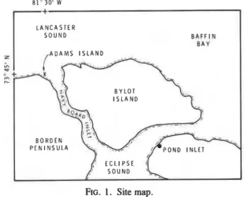
Adams Island (73"44'N, 81°28'W) is a natural island approximately 200m in diameter at the intersection of Navy Board Inlet and Lancaster Sound (Fig. 1). It is about 3 krn from the shore of the Borden Peninsula on Baffin Island and is surrounded by first-year landfast ice for most of the winter. A project is in hand to study ice cover interaction with the island over several seasons in an effort to improve understanding of landfast ice response to wide structures. Observations for the ,winters of 198 111982 and 19821 1983 were reported earlier (Frederking et al. 1983, 1984). The present paper gives in greater detail the measured ice cover movement and deforma- tion for the winter of 198211983. Preliminary examination of the data suggested that the local behaviour of ice at Adams Island might be affected by conditions over a larger scale. Observations for Eclipse Sound are therefore presented as well. Visits to the Adams Island site were made in November 1982, March 1983, and AprilIMay 1983, when markers on the ice were surveyed to determine ice movement. Ice conditions and environmental data were also documented. Monitoring of movements in Eclipse Sound, at Pond Inlet, was carried out from December 1982 to June 1983 at 2-week intervals by the Arctic Research Establishment.
Related literature on landfast ice behaviour is limited. Cooper (1974) studied movement and deformation in the Beaufort Sea, Ito and Muller (1977) conducted another study in the eastern Arctic, and Instanes (1979) has reported on. landfast ice movements near Vestspitsbergen in van Mijen Fjord. Most work on ice interaction with. structures or islands, however, remains proprietry, although published studies include ice interaction with the artificial island of Netserk F-40 in the Beaufort Sea (Strilchuk 1977). Landfast ice movements in the vicinity of the same island were reported by Spedding (1983), and survey techniques similar to those used in the present study
L A N C A S T E R
B A F F I N B A Y
FIG. 1. Site map.
were earlier employed by Hibler et al. (1973) to measure pack ice deformation.
Measurements
Ice cover movements near Adams Island and near the shore at Borden Station were measured by successive surveys of arrays of prism reflectors situated on the ice. An electronic distance measuring (EDM) instrument (Wild DI-20) and a theodolite (Wild T-2) were used to measure distances and angles to the reflectors from fixed base lines on shore. The EDM instrument has an accuracy of * 5 mm for distances up to 1000m; horizontal and vertical angles have an accuracy of 5" of arc. One array of reflectors surrounded Adams Island and another was nearly parallel to the shore at Borden Station. Positions were measured from 20 to 26 March, from 27 April to 7 May, and from 10 to 14 June, usually at 2-day intervals. In addition, some
SAYED ET AL. 347
I
A -m+m > -* .FIG. 2. Aerial view of ice conditions, Adams Island, ApriI 1983.
reflectors near Borden Station were surveyed every 15 min on 26 March and again on 15 June.
An Aanderaa TC-3A tide recorder provided tide readings at 15 min intervals from 20 March to 14 June. It was located 1 km
north of Borden Station in 5 m of water. A current meter
(Aanderaa RCM-4) installed 2 km northwest of Adams Island recorded current velocity at 10 min intervals from 16 April to 11 June. Wind and temperature were also recorded at Borden Station for the periods of observation. Ice thickness and salinity were measured at several locations from November 1982 to
June
1983.Ice cover movements on Eclipse Sound were measured near
the community of Pond Inlet. These and measurements of ice
thickness and salinity, air temperature, wind, and tide were carried out by the Arctic Research Establishment (Steltner
1984).
Results
An aerial photograph of Adams Island shows the surrounding conditions (Fig. 2). Throughout the period of observation ovember 1982 to June 1983) first-year landfast ice and a few unded multiyear floes covered the region. Most of the ectors used to measure ice movement were separated from ch other by numerous cracks. Ice thickness was between 0.27
d 0.60111 in November, 1 . 9 m in late March, and 1.7m in
ly May. Measurements taken southwest of the island in an
a of flat ice (station 7) and north of the island in a rough ice
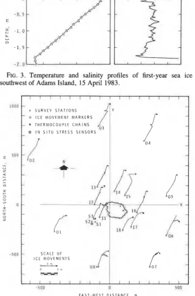
a (station 8) are given in Table 1. Typical temperature and alinity profiles of first-year ice are shown in Fig. 3. Grounded
TABLE 1 . Ice thickness at Adams Island*
Thickness, m Freeboard, m Snow, m
Date Stn. 7 Stn. 8 Stn. 7 Stn. 8 Stn. 7 Stn. 8
83-03-22 1.956 1.897 0.121 0.126 0.200 0.200 83-04-15 1.900 1.889 0.150 0.141 0.055 0.052 ,8344-29 1.824 1.638 0.164 0.118 0.076 0.103 83-05-23 1.680 1.140 - - - -
*Stations 7 and 8 are southwest and north of the island, respectively.
T E M P E R A T U R E , " C S A L I N I T Y , 0 1 0 0
FIG. 3. Temperature and salinity profiles of first-year sea ice southwest of Adams Island, 15 April 1983.
-5011 u 5 a ~
E A S T - W E S T D I S T A N C E . rn
I I I I I I ~ I I I I I I I I I
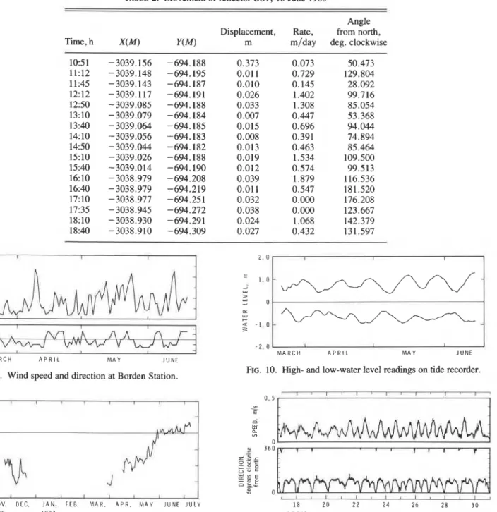
FIG. 4. Ice movement array and ice movements at Adams Island, March-June 1983. - t S U R V E Y S T A T I O N S - 0 I C E M O V E M E N T M A R K E R S - * T H E R M O C O U P L E C H A I N S ~3 I N S I T U S T R E S S S E N S O R S
rubble accumulated round the island, mostly on the southwest side.
Coordinates of reflectors were calculated from measured distances and angles from fixed points on the island or on the shore. East was taken as the positive x-direction and north as the positive y-direction. The origin was chosen as the end of one of the base lines on Adams Island. Movement vectors of the ice cover round the island and near the Borden shore are shown in Figs. 4 and 5. All reflectors appeared to move at approximately
-
ly
-:k
.
i
I
-
-4--
-
-
--
-i
- - --
S C A L E O F I C E M O V E M E N T S --
5 m 0 , m 06 --
--
S
i
-
I I I I I I I I I I I I l I I ,CAN. GEOTECH. J. VOL. 23, 1986 I S C A L E O F I C E M O V E M E N T S A O k i d" 0 L L N M A R C H A P R I L M A Y JUNE LL
-
w N M A R C H A P R I L M A Y JUNE - 2 5 0 0 LL U Z 4: t "'-
0 - 5 0 0-
-
C 3 0 "' I + = 0 Z-
-3500 - 3 0 0 0 E A S T - W E S T D I S T A N C E , mFIG. 5. Ice movement array and ice movements at Borden Station, a
March-June 1983. "'0
similar rates and in the same direction, i.e., towards the north-northeast at average rates close to 0.1 m/day , the ice
cover pressing against the southwest side of the island. Details N
of movement rates for a typical location (reflector S1) are shown M A R C H A P R I L M A Y J U N E
in Fig. 6a. An example of movement rates on the other side, FIG. 6 . ( a ) Rate of movement and direction southwest of Adams where ice was moving away from the island (reflector 1417 is Island )reflector S l ) ; ( b ) rate of movement and direction north of given in Fig. 6b. The abrupt change in the positions of all Adams Island (reflector 14); ( c ) rate of movement and direction near
reflectors on 5 May 1983 is probably due to an error in Borden Station (reflector BS1).
measuring the horizontal angles.
Movement rates near the Borden Station shore (reflector BS 1) -694 16 , I I 1 I 4
are illustrated in Fig. 6c. All reflectors at that location,
-694 18 including those on grounded multiyear floes, had similar
movement rates and directions and were comparable to the
values measured near Adams Island. As may be seen from Fig. -694 22
5, the ice cover consistently moved away from the shore,
;
-694.24 signalling that new ice might form at the tidal crack immediately g -694.26 adjacent to the shore. This was corroborated by measurements-694.28 of the location markers approximately 30 and 50m offshore.
These measurements were made by tape and thus had much -694.30
- 0-0-0- I
%-,
- -694,20A0,d0-0-0 - --
\o-
-
-
-
-
-\
-lower accuracy than those made using the EDM instrument. It -694.32 I I I I I
-3039.16 -3039.12 -3039.08 -3039 04 -3039.00 -3038.96 -3038.92 -3038.88
was clear, however, that as the markers moved away from the E A S T , m
shore there was little them, i.e. 9
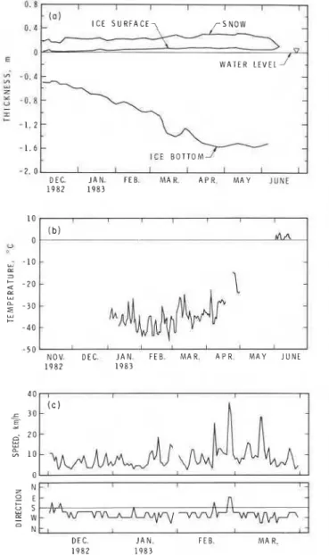
F ~ ~ . 7. MovementS of reflector BS1, 15 June 1983 (measurements
of the movement occurred along the shoreline at the tidal crack. for at intervals, starting Ice movements over shorter periods were surveyed by means
of two reflectors at 15 min intervals on 26 March and 15 June.
The record of reflector BS1 on 15 June is gken in Fig. 7 and 0.039 m. Those during a 1-day interval, however, were of the Table 2; the wind at the time was from the west at an average order of 0.1 m.
speed of 17.5 krn/h. The tide was at a peak, with approximately The daily averages of wind speed measured at Borden Station 2 m difference between high- and low-water levels. The are shown in Fig. 8, the prevailing direction from the west. The movement rate and direction fluctuated more than the values wind was less frequently from the south, and no north wind was measured over longer intervals. It should be noted that ever recorded. Peak values reached 60 km/h on 18 April. the air displacements were relatively small in this case, and that the temperature record was obtained for only part of the above relative accuracy would consequently be low. For example, the period and is shown in Fig. 9.
coordinates of reflector BS1 could be determined to within The tide had a semidiurnal cycle. Daily high- and low-water
SAYED ET AL.
TABLE 2. Movement of reflector BS1, 15 June 1983
Angle
Displacement, Rate, from north,
Time, h X(M) y(M) m m/day deg. clockwise
1051 -3039.156 -694.188 0.373 0.073 50.473 11:12 -3039.148 -694.195 0.01 1 0.729 129.804 11:45 -3039.143 -694.187 0.010 0.145 28.092 12:12 -3039.117 -694.191 0.026 1.402 99.716 12:50 -3039.085 -694.188 0.033 1.308 85.054 13:lO -3039.079 -694.184 0.007 0.447 53.368 I 13:40 -3039.064 -694.185 0.015 0.696 94.044 14:lO -3039.056 -694.183 0.008 0.391 74.894 1450 -3039.044 -694.182 0.013 0.463 85.464 15:lO -3039.026 -694.188 0.019 1.534 109.500 15:40 -3039.014 -694.190 0.012 0.574 99.513 16:lO -3038.979 -694.208 0.039 1.879 116.536 16:40 -3038.979 -694.219 0.011 0.547 181.520 17:lO -3038.977 -694.251 0.032 0.000 176.208 17:35 -3038.945 -694.272 0.038 0.000 123.667 18:lO -3038.930 -694.291 0.024 1.068 142.379 18:40 -3038.910 -694.309 0.027 0.432 131.597 0 -t I 6 0 2. 0 c 7 4 0 x 1 . 0 - d 2 LL
:
2 0 > V) 0 0 Z I IE
Q -1.0 a :I + u s - o N - M A R C H A P R I L M A Y J U N E M A R C H A P R I L M A Y J U N EFIG. 10. High- and low-water level readings on tide recorder.
FIG. 8. Wind speed and direction at Borden Station.
A A A
n r -
* " S W - J V W W V V W V U W - T O 1 0 0 CL 3 2 - 1 0 a w2
- 2 0 u + - 3 0 - 4 0 3 - 2 . 0 NOV. DEC. J A N . F E B . M A R . A P R . M A Y J U N E J U L Y 1 8 2 0 2 2 2 4 26 28 3 0 1 9 8 2 1 9 8 3 A P R I L 1 9 8 3FIG. 9. Air temperatures at Adams Island. FIG. 11.
Water current near Adams Island, 17-30 April 1983.
urrent speed and direction recorded in April is shown in Fig.
11 ; the dominant direction was to the east, and maximum speeds The movement vectors are shown in Fig. 12. Total displace-
o the east-southeast. The recorded peak speed was 0.37 m/s. ment varied from 4.5 to 9.0 m between 17 December 1982 and 7
e current appeared to be dependent on tide and showed June 1983. the corresponding average rate would be from 0.03
semidiurnal cycling (E. Lewis, personal communication, 1984). to 0.05 m/day. Measured over 2-week intervals the rates are of
the same order, but they fluctuated within a larger range, with
,clipse Sound maximums reaching 0.13 m/day. Movement rates for a typical
Ice movements in Eclipse Sound near the shore at Pond Inlet point are given in Table 3. The ice cover movement had a
ere monitored from December 1982 to June 1983. During this westerly component, and points near the shore (within 2 krn)
ime first-year landfast ice covered the sound. The accuracy of also moved to the north away from the shore, as observed on the
he measurements is similar to that for Adams Island. Reflectors Borden shore. Points further away from the shore moved to the
ere placed on a line extending perpendicular to the shore for south, towards the shore. There was no obvious change in
pproximately 7 km. One was offset from this line so that it movement rate as winter progressed, although ice thickness
-auld be used, with other reflectors, to calculate strain. increased from approximately 0.5 m in December 1982 to 1.6 m
0 . 5 w, \ d LL w 0. V) 0 w 3 6 0
-
v
5 5 ~
= - , e
I3
I I I I I I I I S Z E=:
P z- n350 CAN. GEOTECH. J . VOL. 23, 1986 8000 moo fOm E ; 50W " Z q + am - D I + 2 VI Moo- r c = mo 0 z lIKlO a -1000 -5OM) a - 3 0 E A S T - W E S T D I S T A N C E , rn ? C - 4 0
FIG. 12. Ice movement array and ice movements m Eclipse Sound.
- 5 0
N O V . DEC. J A N . F E B . M A R . A P R . M A Y J U N E
TABLE 3. Ice movement in Eclipse Sound (reflector No. 1) 1 9 8 2 1 9 8 3
Rate, Angle from north, 4 0 Displacement,
Date m m/da~ deg. clockwise I c 3 0
E 2d 82-12-17 1.971 0.094 312.88 6 u u 2 0 82-0 1-07 0.523 0.075 309.50 2 1 0 82-01-14 1.104 0.078 308.64 82-01-28 0.796 0.073 309.85 0 82-02- 1 1 0.140 0.047 333.25 z bI 82-02- 18 0.496 0.071 31 1.73 O L s E 0.419 u 82-02-25 0.060 317.04 E W 82-03-04 0.873 0.127 312.96 N 82-03-08 0.267 0.063 166.80 DEC. J A N . F E B . M A R . 1 9 8 2 1 9 8 3 82-03-09 0.066 0.084 353.09
83-06-03 2.227 0.089 300.68 FIG. 13. (a) Ice thickness in Eclipse Sound, reflector 1 ; (6) air
83-06-07 0.165 0.041 309.09 temperature, Eclipse Sound; ( c ) wind speed and direction, Eclipse
---Sound.
in June 1983. Figure 13a records the ice thickness near one of that measured at the beginning of observations. Obviously it is the reflectors. Air temperature and wind velocity for the same impossible to define an "undeformed state for the ice cover. period are given in Figs. 13 b and 13c. The prevailing wind for The present values of strains, however, are small enough that the period was from the west, although it was relatively calm use of different reference lengths (corresponding to the current (below 10 km/h) most of the time. Ice movement is apparently deformed state for example) would give similar results. influenced by factors other than wind. Strains and strain rates calculated from reflectors S 1, S2, and
S3 are given in Table 4. Their magnitude and direction are
Analysis and discussion plotted versus time in Fig. 14. Strains calculated for an adjacent
Measured movements were used to calculate strains and area, using reflectors 11, S2, and S3, are shown in Fig. 15. An strain rates in the ice cover. These correspond to length scales example of the values calculated over larger areas of the ice varying from 30 m to a few hundred metres. At this scale the ice cover (reflectors I1,01, and 0 2 ) is shown in Fig. 16. In spite of cover is not flat and homogeneous but includes numerous the apparent uniformity of movements, calculated strains cracks, rafted and ridged areas, and multiyear floes, some showed considerable scatter. Strain rates varied from lop8 to grounded. lo-'' s-' over short time intervals (2 days), but were more
Movements of sets of three reflectors were used to calculate consistent over longer durations of the order of 1 month. average strains along the sides of triangles. These linear strains The total strains accounting for ice cover deformation near were then resolved to give the components of the strain tensor Adams Island from March to June 1983 are shown in Fig. 17. and, from the interval between measurements, the strain rate The magnitude of the total strain change during this period is tensor. Linear strains were calculated by dividing the length of the order of lop3. Reflectors forming nearly equilateral change between two reflectors by an original length chosen as triangles were used in the calculations in order to obtain the best
I 1 1
pNO.
- p NO. 1.7-
p NO. 1.6-
,-NO. 1.5 - fi NO. 1.4 +NO. 1.3-
a SCALE OF ICE 1 0 - MOVEMENTS 0 5 m u 0 U - G - 1 0 LL 3 2 - 2 0 I LL -4000 -3000 -2000 -1000 0 loo0-
0. 8 I I I I I I I D. d-
- 0 . 1 YI ZE
- 0 . 8-
I + - 1 . 2 - 1 . 6 -2.0 D E C J A N . F E B . M A R . A P R . M A Y JUNE 1 9 8 2 1 9 8 3 0- v W A T E R L E V E L-
- - -:
:
- I I I I C E B O T T O M I I I 1:
\SAYED ET AL.
TABLE 4. Principal strains and strain rates southwest Adams Island, reflectors S1, S2, S3
Principal strain Principal strain rate
Date Major Minor Angle* Major Minor Angle*
*Degrees clockwise from north.
-
-
0-0 M A J O R--.
0---o M l N O R -'= - --...
..
2 0 3 0 9 1 9 29 9 1 9 2 9 8 M A R C H A P R I L M A Y J U N E 1 9 8 3FIG. 14. Principal strains among reflectors S1, S2, and S3.
I I I I I 1 I I
P
0-6 M A J O R
-
0---o M I N O R - -I-
&--- ---o.&,
1 1 &--\;
---
--
I
---
-
-.
M A R C H A P R I L M A Y J U N E
1 9 8 3
FIG. 15. Principal strains among reflectors 11, S l ,and S3.
" -
2 0 3 0 9 1 9 29 9 19 2 9 8
M A R C H A P R I L M A Y J U N E
1 9 8 3
FIG. 16. Principal strains among reflectors 11, 0 1 , and 0 2 .
possible accuracy. Other combinations of reflectors, not shown in Fig. 17, were also examined. The scatter of the results is similar to that discussed above. Although directions of the principal strains in Fig. 17 show some scatter, it seems that compressive strains acted along directions nearly perpendicular to the shore of the island. Tensile strains occurredin most of the ice cover except to the south where the largest ice movements against the island took place.
Strains and strain rates in Eclipse Sound at Pond Inlet are shown in Fig. 18 and Table 5. The values are of the same order as those observed near Adams Island, an unexpected develop- ment because the ice cover is not constrained by any obstacle, unlike that in the vicinity of Adams Island. The above values were calculated for the triangle connecting reflecors 0.4, 1 .O, and 1.2; side lengths are of the order of 1 km. Uniaxial strains and strain rates were also calculated for the array at Eclipse Sound (Table 6). Strain was calculated from the change in the length of the imaginary line connecting two adjacent reflectors. The first point to note is that strain in a direction parallel to the
CAN. GEOTECH. I. VOL. 23, 1986
TABLE 5. Principal strains and strain rates in Eclipse Sound, reflectors 0.4, 1 .O, 1.23
Principal strain Principal strain rate
Date Major Minor Angle* Major Minor Angle*
*Degrees clockwise from north.
TABLE 6. Total uniaxial strain and average strain rate data, ice movements in Eclipse Sound, winter 1982- 1983
Distance Duration Relative Average
Pairs of Relative between Total of rate of strain
movement movement, stations strain measurements, measurements, rate,
stations m m change days m/day s-I
0.4-1.0 1.410 1026 -13.1 X 171 0.008 -0.89 X lo-'' 1.0-1.1 - 1.430 206 69.8 x 171 0.008 4.75 X lo-'' 1.1-1.2 -1.864 1159 16.1 X 143 0.013 1.30 X lo-'' 1.2-1.3 - 1.630 932 17.5 X 143 0.01 1 1.42 x lo-'' 1.3-1.4 -1.246 983 12.7 X 129 0.010 1.14 X lo-'' 1.4-1.5 -1.075 997 10.5 X 129 0.008 0.95 x lo-'' 1.5-1.6 -0.897 1101 7.9 x lo-4 129 0.007 0.71 X lo-'' 1.6-1.7 -0.758 986 6.9 x lo-4 129 0.006 0.62 X lo-'' 1.7-1.8 -0.725 1064 6.0 x lo-4 129 0.006 0.54 x lo-''
shore is extensional (tensile) and that strains normal to the shore are compressive; as well, the total strain change over the measurement period was less than lop3. Another feature of the strains and movements is a decrease in their magnitude with distance from shore.
These results suggest that adopting a continuum approach to describe the overall strains and strain rates of an ice cover (100 m2 in area) can give consistent values. This is especially true over long periods of the order of 1 month. Strains account for actual ice deformation as well as for the rearrangement and breaking of separate ice floes. Part of the compressive strains may be due to rafting or ridging and part of the tensile strains to cracking.
Movement rates of the ice cover could be used to estimate the total load on the island (Sanderson 1984). Ponter et al. (1983)
developed a method of calculating an upper bound of the total load exerted by an ice sheet undergoing secondary creep on a structure. Considering 2 m thick columnar ice at
-
1 1°C and 5 ppt salinity, a movement rate of 0.1 m/day gives a total load of 94MN on the 200111 width of the island (average stress of 235 kPa). A higher movement rate of 1 .O m/day may occur over short periods of less than 1 day; this gives a total load of 200 MN (average stress of 500 kPa). Bruen and Vivatrat (1984) used a different approximate method, one that gives higher upper bounds of the total loads. The conditions at Adams Island give average stresses of 370 and 800kPa, corresponding to move- ment rates of 0.1 and l.Om/day, respectively. As discussed earlier (Frederking et al. 1984), estimates based on strainmeasurements over small lengths (approximately 0.3 m) gave average stresses below 70 kPa and a peak value of 140 kPa. Direct stress measurements were conducted by Hamburg Ship Model Basin (HSVA) as part of the project. An array of small vibrating wire (IRAD) transducers was deployed around the southeast quadrant of the island. The results were reported by Frederking et al. (1984). The maximum measured stress was
370 kPa in the top 0.5 m of the ice sheet and 50 kPa below that. The peak stress averaged over the ice sheet thickness would be 140 kPa. Further discussion of these measurements is available (Frederking et al. 1984).
It appears that stresses calculated by means of the method proposed by Ponter et al. (1983) are much higher than those
measured directly or obtained from measurements of strain over small length scales. The assumption of secondary creep contributes to overestimated stresses. The measured global strains were mainly less than 2% for the period March to June. The total strains in the ice are probably of the same order. According to Gold (1983), creep at such strains would be transient. He also showed that strain rate depends approxi- mately linearly on the stress within the range of present stresses. The use of Gold's data for freshwater columnar-grained ice and correction for salinity reduces the reference stresses well below those calculated assuming secondary creep. Another factor influencing stress calculations is the reference strain rate. According to Ponter et al. (1983), an ice velocity of 0.1 m/day
corresponds to a reference strain rate of 1.3 x l o p 7 s-'. The measured strain rates were much lower, for the most part
SAYED ET AL. 353
predicting local movements at a smaller scale near Adams Island.
Summary and conclusions
Ice cover movements and deformations are descibed for the winter of 198211983 near Adams Island and in Eclipse Sound at Pond Inlet. Displacements and displacement rates were deter- mined by means of repeated surveys of reflectors placed on the ice. The relative movements of the reflectors were used to calculate strains and strain rates over distances varying between 30m and a few hundred metres. The intervals between measurements varied from 2 days to 1 month, although limited measurements were taken at shorter intervals of 15 min.
Movements near Adams Island proved to be north-northeast at a rate of approximately 0.1 mlday. Those in Eclipse Sound were of the same order, but to the west. Ice appeared to move away from the shoreline at both Borden Station and Pond Inlet. Strain rates were of the order of lo-'' s-' in both locations. Strains measured using different combinations of reflectors were consistent over long periods (approximately 1 month), but showed some scatter over shorter periods.
Average (upper bound) ice stresses against the island, determined from ice movement rates, varied from 235 to 500 kPa; those determined from strain measurements or direct measurements were 70-140 kPa. The difference is attributed to the inadequacy of the upper bound method to reflect the presence of macroflaws in the ice cover.
These results are part of a larger project that includes measure- ments of stresses, strains at small scales, and meteorological conditions. Correlation of the various factors governing landfast ice interaction with an island still requires study.
Acknowledgements
The logistic support provided by the Polar Continental Shelf Project is gratefully acknowldged, as is the permission from the Department of Fisheries and Oceans to use facilities at Borden Station and the financial support of Supply and Services Canada and the Panel of Energy Research and Development. Technical support in the field was provided by the Arctic Research Establishment, Pond Inlet. Valuable assistance in the laboratory and in the field was provided by J. D. Neil, Technical Officer, National Research Council, Canada, and by M. Inoue, Visiting Researcher, Nippon Kokan K.K., Japan, and is gratefully acknowledged. Finally, the collaboration of colleagues from the Hamburg Ship Model Basin (HSVA) and British Petroleum (BP) in this project is much appreciated.
This paper is a contribution from the Division of Building Research, National Research Council of Canada.
BRUEN, F. J., and VIVATRAT, V. 1984. Ice force prediction based on strain-rate field. Thud International Offshore Mechanics and Arctic Engineering S ymposium, New Orleans, LA, Proceedings, Vol. 3, pp. 275-281.
COPPER, P. F., JR. 1974. Landfast ice in the southeastern part of the Beaufort Sea. Symposium on Beaufort Sea Coast and Shelf Research, San Francisco, CA, Proceedings, pp. 235- 242.
FREDERKING, R. M. W., SANDERSON, T., WESSELS, E., and INOUE,
M. 1983. Ice behaviour around a small Artic island. V l T Sym- posium 28, 7th International Conference on Port and Ocean Engineering under Arctic Conditions, Helsinki, Finland, Proceed- ings, vol2, pp. 875-887.
FREDERKING, R. M. W., SAYED, M., WESSELS, E., CHILD, A. J., and
BRADFORD, D. 1984. Ice interaction with Adams Island, winter 1982-1983. IAHR Ice Symposium, Hamburg, West Germany, Proceedings, Vol. 3, pp. 187-210.
354 CAN. GEOTECH, J. VOL. 23, 1986
GOLD, L. W. 1983. Creep of columnar-grained ice at low stress. SANDERSON, T. J. 0. 1984. Theoretical and measured ice forces on
Annals of Glaciology, 4, pp. 73-78. wide structures. IAHR Ice Symposium, Hamburg, West Germany.
HIBLER, W. D., HI, WEEKS, W. F., ACKLEY, S., and K o v ~ c s , A. SPEDDING, L. G. 1983. A large landfast ice movement. Seventh
1973. Mesoscale strain measurements on the Beaufort Sea pack ice International Conference on Port and Ocean -Engineering under
(AIDJEX 197 1). Journal of Glaciology, 12(65), pp. 187-206. Arctic Conditions, Helsinki, Finland, Proceedings, Vol. 3, pp.
INSTANES, B. 1979. Coal loading pier in Svea, Svalbard. Fifth 203-213.
International Conference on Port and Ocean Engineering under STELTNER, H. A. R. 1984. Data acquisition at Eclipse Sound and
Arctic Conditions, Trondheim, Norway, Proceedings, Vol. 3, pp. Adams Island to study large-scale deformation of sea ice surface and
217-227. variations-year No. 2, Arctic Research Establishment, Pond Inlet,
ITO, H., and MULLER, F. 1977. Horizontal movement of fast ice in the N.W.T., Final Report Effort #1- Eclipse Sound. Contract No. 24
North Water area. Journal of Glaciology, 19(81), pp. 547-554. SR.FP-3-2041, for Department of Fisheries and Oceans.
PONTER, A. R. S . , PALMER, A. C., GOODMAN, D. J., ASHBY, M. F., STRILCHUK, A. R. 1977. Ice pressure measurements, Netserk F-40,
EVANS, A. G., HUTCHINS INS ON, J. W. 1983. The force exertedby a 1975-76. APOA Project No. 105-1. Arctic Petroleum Operators' '
moving ice sheet on an offshore structure. Cold Regions Science and Association, Calgary, Alta.
Technology, 8, pp. 109-1 18.