HAL Id: halshs-02975342
https://halshs.archives-ouvertes.fr/halshs-02975342
Submitted on 4 Jan 2021HAL is a multi-disciplinary open access archive for the deposit and dissemination of sci-entific research documents, whether they are pub-lished or not. The documents may come from teaching and research institutions in France or abroad, or from public or private research centers.
L’archive ouverte pluridisciplinaire HAL, est destinée au dépôt et à la diffusion de documents scientifiques de niveau recherche, publiés ou non, émanant des établissements d’enseignement et de recherche français ou étrangers, des laboratoires publics ou privés.
Chronicle of a destruction foretold: a belated
reassessment of the preservation status of Neolithic
habitation sites in the Kadruka concession (Northern
Dongola Reach, Sudan)
Olivier Langlois, Gilles Durrenmath, Lamya Khalidi, Hisham Khidir Ahmed
Karrar, Ahmed Karrar, Lucie Cez, Lionel Gourichon, Hassimi Sambo,
Charlotte Pruvost
To cite this version:
Olivier Langlois, Gilles Durrenmath, Lamya Khalidi, Hisham Khidir Ahmed Karrar, Ahmed Karrar, et al.. Chronicle of a destruction foretold: a belated reassessment of the preservation status of Neolithic habitation sites in the Kadruka concession (Northern Dongola Reach, Sudan). Sudan & Nubia. The Sudan Archaeological Research Society, 2019, 23, pp.61-67. �halshs-02975342�
1
Chronicle of a destruction foretold: a belated reassessment of the preservation status of
Neolithic habitation sites in the Kadruka concession (Northern Dongola Reach, Sudan)
Olivier Langlois, Gilles Durrenmath, Lamya Khalidi, Hisham Khidir Ahmed Karrar, Lucie Cez, Lionel Gourichon, Hassimi Sambo and Charlotte Pruvost
Owing to research conducted by Jacques Reinold in the Kadruka concession in the 1980s-1990s, this area is renowned for including several Neolithic cemeteries, which have revealed particularly rich graves. We will not deal with these cemeteries in this paper but with another type of site, which, according to the literature, was erased from the archaeological record long ago. Across the entire Kadruka concession, it is generally believed that cemeteries are the only Neolithic sites to have been sufficiently spared from erosion to have retained a relatively good preservation status today. This does not only concern the Kadruka concession but the entire Northern Dongola Reach, where it has been largely assumed that no in situ Neolithic habitation sites remain, save for a few rare windows where such sites may have been protected from large-scale erosional processes. However, studies carried out since 2014 within the Kadruka concession with the support of a grant from the Qatar-Sudan Archaeological Project (mission QSAP-06) not only challenge this view, but also call for a general reconsideration of the livelihood and mobility of populations who occupied the Northern Dongola Reach during the Middle Neolithic (5th millennium BC).
Many researchers have outlined the difficulty of reliably assessing the way of life and subsistence economy of Prehistoric populations without habitation site data (Reinold 2004b, 152; Welsby 2001, 551; Usai 2016, 18). Within our study area the lack of such sites has had a particularly unfortunate consequence, since their alleged destruction has led some to approach the above-mentioned issues without taking into account the large areas in many parts of the Wadi el-Khowi abundantly scattered with artefacts (cf. e.g. Wengrow et al. 2014, 104). This has anchored the view that the area was mostly peopled with nomadic pastoralists. As this view begins to be challenged in light of the discovery of domesticated plant remains in the R12 cemetery (Madella et al. 2014; Out et al. 2016) – which in turn has shed new light on the barley deposits previously found in several graves at KDK1 (Reinold 2000, 57-58) – it seems useful to demonstrate that the basis of this argument partly relies on the inaccurate evaluation of the preservation status of habitation sites previously identified within the Kadruka concession, and how this durably skewed the debate on the way of life and mobility of regional Neolithic peoples. Through such a demonstration, this paper aims primarily to restore these sites to their rightful place in future discussions. This will be followed by an overview of habitation sites identified in the Kadruka concession, including a description of their main features, in light of the study of KDK23H. This will shed new light on the occupation of the Wadi el-Khowi during the Middle Holocene. Characteristics of studied habitation sites, as well as settlement patterns deduced from distribution of sites, do not appear to only be attributable to nomadic pastoralist populations – a lifestyle usually associated with these Neolithic populations.
The evolution of a mistaken belief
Located on the right bank of the Nile between the 3rd and 4th Cataracts and 30km north of Dongola (in the Northern Dongola Reach), the Kadruka concession is bounded to the north and south by the Kerma and Kawa concessions respectively. In the mid-1980s, advised by the Sudan National Corporation for Antiquities and Museums (NCAM) of the increasing agricultural pressure that threatened the sites in the area, Reinold initiated a lengthy program primarily focused on the study of several Neolithic burial grounds. He entirely or partially excavated six cemeteries (KDK1, KDK2, KDK13, KDK18, KDK21, KDK22) and made test-pits in many others. While none of these excavations were extensively published, he integrated data from three of them (KDK1, KDK18 and KDK21) into several papers in which he presented the more salient findings, a general view of the funerary practices and the main features of each cemetery, as well as their respective chrono-spatial patterns (Reinold 2000; 2001; 2004a; 2004b). Thanks to these articles, the Kadruka cemeteries have become
2
famous, not only for their rich funerary goods, but also for having produced the first evidence that barley was used in Nubia as early as the Neolithic (KDK1: late 5th millennium BC). They provided clues suggesting that the process of increasing social complexity – which led to the Kerma kingdom two millennia later – was rooted in the local Neolithic. In parallel with the cemetery excavations, Reinold undertook a general survey of the concession that revealed a chrono-spatial distribution of sites. Within the Kerma basin that extends over the western part of the concession, most sites identified date to the Kerma (c. 2400-1450 BC) and post-Kerma periods, while within the area crossed by the Wadi el-Khowi located further east, the sites generally concern older periods, namely Middle Neolithic (c. 5th millennium BC) but also the Pre-Kerma period (c. early 3rd millennium BC) (Leclant and Clerc 1992, 306-307; Reinold 2001, 5; 2004b, 162). This distribution, also attested farther north and south in the adjacent concessions of Kerma and Kawa (Welsby 2000; 2001; Welsby et al. 2001; Honegger 2005a; 2007; 2014), is merely due to the Nile shifting from its ancient course (called the Wadi el-Khowi) to the present one, situated a dozen kilometres further west (Marcolongo and Surian 1997).
Concerning the Neolithic period, Reinold mentions two main categories of sites, both located close to the channels forming the Wadi el-Khowi braided stream system: the cemeteries we have already mentioned and another type of site the author named ‘épandage de matériel’, an improper locution that one might translate as ‘surface scatter site’ (Reinold 1987; 2000, 46-47, 76; 2004b, 162). A dozen of these ‘épandages’ are mentioned in Reinold’s notes. Most of them are described as vast areas studded with many surface artefacts. They are often band-shaped, sometimes extending over several kilometres more or less along the Wadi elKhowi branches. Reddish spots of burnt clay (often named ‘burnt features’) were often noted within their perimeters. Reinold carried out limited studies on a few of these scatters to define their characteristics, evaluate their preservation status or, when funerary goods were found in the vicinity, to look for burials. This was particularly the case for KDK29, KDK34, KDK51, KDK52, KDK531 where sand and the first centimetres of silt were removed
over variable surfaces, and where a few test-pits were dug (Leclant and Clerc 1991; 258; 1992, 307). Available information about these field operations is scarce and they have thus been largely ignored by scholars. For most of the areas tested, we found no mention of archaeological features in Reinold’s field notes, leading us to postulate that nothing noticeable was observed below the sand. However, this was not the case for ‘plain site’ KDK29, which, according to Reinold, dated to the Neolithic or the Protohistoric period, and on the surface of which many domestic faunal bones were visible (Leclant and Clerc 1991, 258)2. Little information is available on this site apart from a myriad of
postholes, with a density of c. 18 features per m² within a 216m² area cleared of sand (Leclant and Clerc 1991, 258, fig. 93), but no habitation plan was perceived. Despite this discovery, Reinold stated in several papers that Neolithic habitation sites had been destroyed by erosive processes over the entire Kadruka concession. According to him, these processes would have evacuated sediment over a depth exceeding 0.5m, dismantling all stratified Neolithic period layers (Reinold 2000, 76; 2004a, 42). The many surface scatter sites observed in the concession were interpreted by him as palimpsests resulting from intense erosion of prehistoric habitation sites. Having become palimpsests, these sites provided no more than typological information on the mixed artifact assemblages they contained (Reinold 2000, 76; 2004a, 42; 2004b, 152).
This conclusion has been largely accepted by regional scholars despite the hundreds of postholes discovered by Reinold at KDK29. Having been published, it is surprising that these postholes did not lead to further investigation of the extent and intensity of processes responsible for the destruction of these habitation sites. As was later asserted in publications of surveys in the Kawa concession south of Kadruka, Reinold’s conclusion was readily accepted. Like at Kadruka, the Kawa survey revealed that in addition to many cemeteries, Neolithic period occupations were simply vast ‘occupation scatters’ covered by abundant surface artefacts (Welsby 2000, 131; 2001, 569).
1 And perhaps KDK5 where an area still shows traces of prior excavation, possibly archaeological, but about which we found no mention of archaeological test-pits.
3
According to Welsby (2000, 131), while ‘few areas are devoid of at least some artefacts which may be assumed to predate the Kerma period’, most of the ‘occupation scatters’ discovered are adjacent to the main palaeochannels, a distribution which ‘might only result from the special intensity of surveys carried out in these areas’ (Welsby 2001, 569). At these sites, some ‘hearth-like features’ (Welsby 2001, 569) and ‘pots smashed into little pieces and left as lay’ (Welsby 2000, 131) were observed. Welsby (2000, 134) accepted Reinold’s view, admitting that ‘this scale of erosion will have totally removed the occupation surfaces and whatever structures there may have been in the Neolithic settlements and has removed the Neolithic ground surfaces (and tomb monuments?) in the cemeteries […]’. Even the discovery of several Neolithic habitation sites beneath the eastern necropolis of Kerma (cf. Honegger 1999) did not lead researchers to challenge this view. One of these sites, S8, was nonetheless excavated and revealed around twenty hearths and many postholes which delineated fences and huts (Honegger 2001). Artefacts and bones were found on the surface of this site dated to the mid-5th millennium BC, but Nile floods probably leached the ground and moved them (Honegger 2001, 223).
Reinold and Welsby seem to share the view that the course of the Wadi el-Khowi was rather intensively occupied by Middle Neolithic populations (probably those who buried their dead in adjacent cemeteries) whose settlements were badly eroded to the point of becoming mere surface scatter sites. However, their views about both the lifestyle and the density of these populations seem to differ slightly. In that respect, Reinold (2001, 5) states that ‘the most easterly course, colonised from the Mesolithic, supported a large population during the Neolithic’, even adding that “the density of archaeological sites is in direct relation to the rich agricultural potential of this zone” (cf. also Reinold 2000, 76). According to Welsby (2000, 135), the populations who occupied the area in the Neolithic period utilised ‘the banks of the palaeochannels but probably with a nomadic or semi-nomadic lifestyle based only a part of the year along the channels’. But the author acknowledges elsewhere that ‘one should bear in mind that the occupation scatters of today may have been permanent settlements in the Neolithic period’ (Welsby 2001, 569). According to Welsby, however, a high population density is yet to be proven. He adds that the context of these ‘occupation scatters’ is not favourable for evaluating occupation density because ‘another effect of sites is that, with the progressive removal of occupation deposits, the heavier artefacts – stone tools and pottery in particular – have been concentrated onto the present ground surface giving a false impression of the density of occupation in that period’ (Welsby 2000, 134). With regards to Honegger’s view, it is noteworthy that, while he had first ascribed site S8 to pastoralists who settled there during the dry season (Honegger 2005b, 16), he then casts doubt about such mobility, suggesting that they may have ‘lived in sedentary villages, with only a segment of the society moving to find new pastures’ (Honegger 2014, 28).
Since the early 2000s, the information available on the Wadi el-Khowi has indicated that this ancient course of the Nile is not only the location of dozens of cemeteries, but also that of vast surface scatter sites supposedly resulting from the destruction of many habitation sites. Thus, for twenty years it was known that the Wadi el-Khowi area included vast areas covered with habitation sites, the distribution of which conforms to what one would expect from a peopling by Neolithic communities living temporarily, perhaps even permanently, along the branches of its channels. However, these communities are still often seen as nomadic peoples who roamed the area. For instance, to justify their doubts about both regional Neolithic sedentism and farming, and while acknowledging that ‘research at Kadruka has privileged cemeteries over settlements’, Hildebrand and Shilling (2016, 85) underline that ‘no remains of mud-brick architecture, pits or other indications of long-term settlement or storage facilities have been described’. With regard to burial mounds which were eventually considered ‘pastoralist cemeteries’ (Sawchuk et al. 2018, 194), they are sometimes attributed to groups who were moving across a large territory and who buried the dead in these ‘preferred locations’ (Edwards and Sadig 2011, 45-46, cf. also Wengrow et al. 2014, 104).
4 Back to the field
When our team resumed work in the Kadruka concession in 2014, available information on the area suggested no hope of accessing in situ remains from the world of the living and we assumed we would only be confronted with funerary sites. However, when we began fieldwork on the KDK23 cemetery, we noted that the ground was strewn with thousands of surface artefacts to its west. Aware of the contradiction between the observations that Reinold made at KDK29 and his statement about the general destruction of habitation sites, we decided to evaluate their preservation status by testing this surface scatter site, that we called KDK23H. We have thus added a settlement component to the original Kadruka project, that is dedicated on the one hand to understanding Neolithic and Pre-Kerma settlement patterns and on the other to a general understanding of the organisation of a few habitation sites.
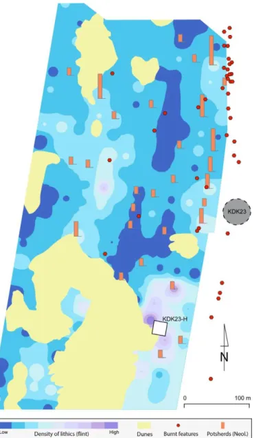
The first task we set for testing the status of KDK23H consisted of artefact counts across c. 250 plots of 4m² in order to obtain a density map, and to map all features visible on the surface (Figure 1). This preliminary approach revealed two areas with high artefact densities, contrasting with a large band-shaped area (on the western base of the cemetery, extending on a north-south axis) where artefacts were much fewer. Another noteworthy phenomenon was the unusually high density of potsherds recorded along a line, extending from the base of the burial mound towards the north and plotted with many burnt features. Since these features are assumed to be remains of trees belonging to ancient riparian forests that grew along the channels (Edwards and Sadig 2011, 39), we suspected the presence of a palaeochannel, the course of which corresponded to the band of low-density artefacts. In this scheme, the relatively high density of sherds north of the cemetery is also explained satisfactorily. Indeed, if the eastern bank of this channel bordered the cemetery, then some potsherds coming from the graves damaged by flooding could have been carried northwards by the stream. We selected the ideal area for investigation from this hypothesis. The area was chosen outside the theoretical path of the channel and where highest artefact densities were observed. After the surface of the area was scraped a few centimetres, a multitude of little pits appeared (Figure 2). Hundreds of postholes were identified, though plans of structures were difficult to delineate; however, this fieldwork enabled us to broadly outline the spatial organisation of this Neolithic habitation site.
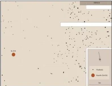
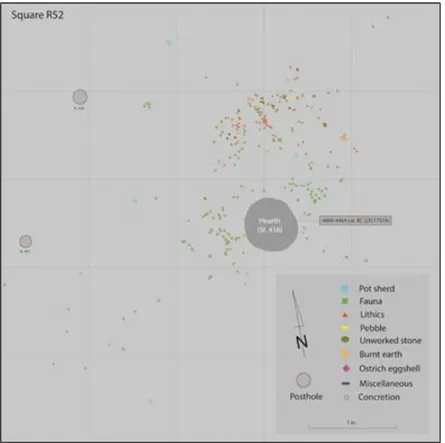
Two features are especially noteworthy at KDK23H. First, the posthole density was higher in the eastern than in the western part of the study area. The second noticeable feature was revealed when excavating a trench in the north-east corner of the area (Figure 3). This trench confirmed that this location coincided with an active channel. In addition to a series of postholes found at different levels, we discovered two pits (St. 29 and St. 193) containing domestic faunal remains in their fill deposits (Plate 1). These pits were dated respectively to 4050-3800 Cal. BC (LTL15775A) and 4350-4070 Cal. BC (LTL15772A), while a layer also belonging to the upper channel filling provided two more dates: 4320-3990 Cal. BC (LTL15773A) and 4450-4170 Cal. BC (LTL1574A). These four dates range from 4450 Cal. BC to 3800 Cal. BC, demonstrating that the area was inhabited repeatedly at the nexus between the 5th and the 4th millennia, and that the channel probably ceased to flow in the early 4th millennium BC. Further west, where the postholes are much fewer, the only prominent feature is a basin-shaped hearth surrounded and covered by ash layers (Plate 2). This structure (St. 416), which dates back to the late first half of the 5th millennium BC (4690-4464 cal. BC, LTL17578A), is older than all those discovered within the upper channel filling. Many artefacts (mostly flint flakes and splinters, and bone fragments) were scattered around this hearth (Figure 4). While the bone fragments (which include cattle and caprine remains) were distributed all around the hearth, lithics were primarily found to its north. Most notable was that the flake and splinter assemblage could be retrofitted into a series of small cobbles chipped on the spot (Plate 3). Such a reconstitution ensures that the hearth surroundings were entirely in situ. These discoveries confirm that some of the many occupation scatters seen in the Kadruka concession overlay not only a multitude of postholes and pits, but also in situ occupation surfaces.
Admittedly, the huge number of artefacts visible on the surface over vast areas casts no doubt on the intensity of aeolian erosion which has reduced many settlements to palimpsests only suitable for
5
typological studies. But there is now evidence that many surface scatter sites are still worthy of more intensive archaeological investigation. These sites should no longer be seen as mere ‘occupation scatters’ but as real ‘habitation sites’ that are often partially stratified, with variable preservation from one site to another, but also over very short distances, and particularly according to their topographic locations (especially against channels).
It is still too early to address many of the questions the data collected at KDK23H raise. However, this data clearly calls for a reconsideration of interpretations of the lifeways of Neolithic populations who occupied the Wadi el-Khowi area over the course of the second half of the 5th millennium BC. The many postholes we found within the upper filling of the palaeochannel corresponding to this period suggest that these people were not nomadic, but that they were settled within the bed and on the western edge of this water course, at least for part of the year. This situation is not unique to this channel. Many sites have revealed high densities of postholes in areas deflated by wind, to the point of suggesting that most of these watercourses had been regularly and maybe densely inhabited. Studies recently carried out 2km west of KDK23H in an area crossed by several channels indicate that these habitation sites do not only pertain to the 5th millennium BC, but also to the following two millennia. They cover a sequence stretching over at least one and a half millennia, from the mid-5th (middle Neolithic B) to the early 3rd millennium BC (Pre-Kerma). This includes the 4th Millennium BC, a period hitherto seen as a gap in the regional chronological sequence (Honegger 2014; Honegger and Williams 2015). Indeed, two of the main band-shaped habitation sites (KDK5B and KDK5A) identified were respectively dated to the mid-4th and the early 3rd millennium BC. Tests pits carried out on these sites have once again revealed hearths and high concentrations of postholes.
Conclusion
Although the ‘surface scatter sites’ located in the Kadruka concession have long been assumed to be vestiges of habitation sites fully deflated by erosion, recent studies have demonstrated that they are often sufficiently preserved to warrant archaeological investigation. A correlation of the results of our study of KDK23H and those of surveys carried out in a few restricted areas of the concession suggests that along most of the Wadi el-Khowi branches, anthropic structures were present at some point during the chronological sequence. The small areas already surveyed clearly confirm that most of these habitation sites were distributed along the channels. But, because these sites have succeeded one another over centuries and have been leached by seasonal flooding, their frequency, durability and density are still difficult to evaluate. Either way, the recurrent discovery of postholes below the sand casts no doubt on the fact that the banks and the upper filling of most channels (the courses of which are generally marked on the surface by hundreds of ‘burnt features’) were environments particularly favoured by Neolithic communities. There are solid grounds to suggest this was also the case over the course of the middle/late Neolithic and the Pre-Kerma periods.
One may wonder why these populations settled, at least for part of the year, in these ever-changing and muddy environments. Even if evaluating the density and durability of these habitats remains a goal, the relatively large size of some postholes in these contexts argue for an investment incompatible with short stays and without seasonal reoccupation. The fact that postholes found at all the sites tested were dug in a succession of stratified silt layers testifies to successive occupations. Nevertheless, it is still difficult at this stage to explain this succession of building phases. Does it result from an erratic or seasonal settlement of the area, or does it only stem from the replacement over time of houses built by settled populations? Since evidence of southwest Asian crops were found in graves of several contemporaneous cemeteries (KDK1, R12), a local farming of these exotic plants might be an explanation for the periodic or permanent presence of people in these wetlands; but evidence that local flood recession farming already existed during the second half of the 5th millennium BC remains to be found.
When Reinold surveyed the Kadruka concession, many sites located in the Kerma basin were already badly damaged by agriculture, while farming was still restricted to very limited stretches of the course of the Wadi el-Khowi, an area described at that time as an ‘archaeological reserve’ (Reinold 2004b, 162). As Plate 4 illustrates, today almost the entire Wadi el-Khowi course – the only place
6
where silt deposits are deep enough for farming without large capital investment – is cultivated, and fields have been increasingly expanding across interfluves where several large farming projects are already in progress. Accordingly, the map of the current farming extension precisely follows the outlines of the palaeochannel (Plate 5). At this point only some very limited stretches of the Wadi el-Khowi palaeochannels are still suitable for archaeological investigation and the last areas still free from cultivation are threatened in the very short-term. The destruction of these sites, erroneously proclaimed two decades ago when the agricultural exploitation of the Wadi el-Khowi course was just beginning, has now become a sad reality. But before the last vestiges of the many habitation sites formerly implanted on the banks and in the bed fillings of the Wadi el-Khowi channels are destroyed by tractors, it is urgent to collect information on some of them and to get protected status for a sample of the others. Such rescue archaeology and site conservation is all the more important given that the information recovered from these sites could profoundly modify our perception of the lifeways of the populations that occupied the area one or two millennia before the emergence of the Kerma kingdom.
Acknowledgments
The ongoing research at Kadruka is conducted in cooperation with the SFDAS (Section Française de la Direction des Antiquités du Soudan) and funded by QSAP (Qatar-Sudan Archaeological Project). Fieldwork is carried out with the authorisation and institutional support of the National Corporation for Antiquities and Museums (NCAM) in Khartoum. We would especially like to thank the director of NCAM, Dr Abdelrahman Ali Muhammad and our NCAM colleagues who supported us and participated in fieldwork operations, namely Amgad Bashir Ali (1985-2014), Mohammed Saad Abdalla and Alsalmani Ezaeldeen Kara. We would also like to thank the people of Kadruka who worked with us and without whom this work would not have been possible. Finally, we dedicate this paper to the late Amgad Bashir Ali and Abd el Ghani Osman Idriss.
Bibliography
Chaix, L. and M. Honegger. 2009. ‘New Data on Animal Exploitation from the Mesolithic to the Neolithic periods in Northern Sudan’, in S. Kerner, R. Dann and P. Bangsgaard (eds), Climate changes in Ancient Societies. Copenhagen, 197-214.
Edwards, D. N. and A. Sadig. 2011. ‘The later Prehistoric Archaeology’, in A. Osman and D. N. Edwards (eds), The Archaeology of a Nubian Frontier. Survey on the Nile Third Cataract, Sudan. Leicester, 37-58.
Hildebrand, E. A. and T. M. Shilling. 2016. ‘Storage amidst early agriculture along the Nile: Perspectives from Sai Island, Sudan’, Quaternary International 412 (B), 81-95.
Honegger, M. 1999. ‘Kerma: les occupations néolithiques et Pré-Kerma de la nécropole orientale’, Genava 47, 77-82.
Honegger, M. 2001. ‘Fouilles préhistoriques et prospection dans la région de Kerma’, Genava 49, 221-228.
Honegger, M. 2005a. ‘Kerma et les débuts du néolithique africain’, Genava 53, 239-249.
Honegger, M. 2005b. ‘Recherches préhistoriques sur les origines de Kerma: des premières sociétés sédentaires à l’émergence du royaume de Nubie’, in C. Bonnet, M. Honegger, P. Lenoble, C. Rilly, and V. Rondot, Kerma et Méroé, cinq conférences d’archéologie soudanaise. Khartoum, 13-17. Honegger, M. 2007. ‘Aux origines de Kerma’, Genava 55, 201-212.
Honegger, M. 2014. ‘Recent Advances in our Understanding of Prehistory in Northern Sudan’, in J.A. Anderson and D. A. Welsby (eds), The Fourth Cataract and beyond. Proceedings of the 12th International Conference for Nubian Studies. Leuven, 19-30.
Honegger, M. and M. Williams. 2015. ‘Human occupations and environmental changes in the Nile valley during the Holocene: The case of Kerma in Upper Nubia (northern Sudan)’, Quaternary Science Review 130, 141-154.
Leclant, J. and G. Clerc. 1991. ‘Fouilles et travaux en Egypte et au Soudan, 1989-1990’, Orientalia 60, 159-273.
7
Leclant, J. and G. Clerc. 1992. ‘Fouilles et travaux en Egypte et au Soudan, 1990-1991’, Orientalia 61, 214-322.
Madella, M., J. J. Garcia-Granero, W. A. Out, P. Ryan and D. Usai 2014. ‘Microbotanical evidence of domestic cereals in Africa 7000 years ago’, PLoS ONE 9(10), e110177.
Marcolongo, B. and N. Surian 1997. ‘Kerma: les sites archéologiques de Kerma et de Kadruka dans leur contexte géomorphologique’, Genava 45, 119-123.
Out, W. A., P. Ryan, J. J. Garcia-Granero, J. Barastegui, L. Maritan, M. Madella and D. Usai 2016. ‘Plant Exploitation in Neolithic Sudan; A review in the light of new data from cemeteries R12 and Ghaba’, Quaternary International 412 (B), 36-53.
Reinold, J. 1987. ‘Les fouilles pré- et proto-historiques de la Section Française de la Direction des Antiquités du Soudan : les campagnes 1984-85 et 1985-86’, Archéologie du Nil Moyen 2, 17-60. Reinold, J. 2000. ‘Archéologie au Soudan. Les civilisations de Nubie’, Paris.
Reinold, J. 2001. ‘Kadruka and the Neolithic in the Northern Dongola Reach’, Sudan & Nubia 5, 2-14. Reinold, J. 2004a. ‘Kadruka’, in D. A. Welsby and J. R. Anderson (eds), Sudan. Ancient Treasures.
London, 42-48.
Reinold, J. 2004b. ‘Le Néolithique soudanais: funéraire et structuresociales’, in J. Guilaine (ed.), Aux marges des grands foyers du Néolithique. Périphéries débitrices ou créatrices. Paris, 151-174. Sawchuk, E. A., S. T. Goldstein, K. M. Grillo and E. A. Hildebrand. 2018. ‘Cemeteries on a moving
frontier: mortuary practices and the spread of pastoralism from the Sahara into eastern Africa’, Journal of Anthropological Archaeology 51, 187-205.
Usai, D. 2016. A Picture of Prehistoric Sudan: The Mesolithic and Neolithic Periods. Oxford.
Welsby, D. A. 2000. ‘South from Kadruka: the Neolithic in the Northern Dongola Reach. Recent Research Into the Stone Age of Northeastern Africa’, Studies in African Archaeology 7, 129-136. Welsby, D. A. 2001. Life on the Desert Edge. Seven thousand years of settlement in the Northern
Dongola Reach, Sudan. London.
Welsby, D. A., M. G. Macklin and J. C. Woodward 2001. ‘Human Response to Holocene Environmental Changes in The Northern Dongola Reach of the Nile, Sudan’, in R. Friedman (ed), Egypt and Nubia, Gifts of the Desert. London, 28-38.
Wengrow, D., M. Dee, S. Foster, A. Stevenson and C. B. Ramsey. 2014. ‘Cultural convergence in the Neolithic of the Nile Valley: a prehistoric perspective on Egypt’s place in Africa’, Antiquity 88, 95-111.
8 Illustrations
9 Figure 2. KDK23H, general plan of the excavated area.
10
Figure 4. KDK23H, distribution of artefacts and ecofacts around hearth St. 416.
11 Plate 2. KDK23H, fill of the basin-shaped hearth St. 416.
12
Plate 4. Development of agriculture along the Wadi el-Khowi from 1984 to 2018.