HAL Id: hal-01447056
https://hal-univ-tlse2.archives-ouvertes.fr/hal-01447056
Submitted on 26 Jan 2017
HAL is a multi-disciplinary open access
archive for the deposit and dissemination of
sci-entific research documents, whether they are
pub-lished or not. The documents may come from
teaching and research institutions in France or
abroad, or from public or private research centers.
L’archive ouverte pluridisciplinaire HAL, est
destinée au dépôt et à la diffusion de documents
scientifiques de niveau recherche, publiés ou non,
émanant des établissements d’enseignement et de
recherche français ou étrangers, des laboratoires
publics ou privés.
Historical seismicity of the Mont Dore volcanic province
(Auvergne, France) unraveled by a regional lacustrine
investigation: New insights about lake sensitivity to
earthquakes
Léo Chassiot, Emmanuel Chapron, Christian Giovanni, Patrick Lajeunesse,
Kazuyo Tachikawa, Marta Garcia, Edouard Bard
To cite this version:
Léo Chassiot, Emmanuel Chapron, Christian Giovanni, Patrick Lajeunesse, Kazuyo Tachikawa, et al..
Historical seismicity of the Mont Dore volcanic province (Auvergne, France) unraveled by a regional
lacustrine investigation: New insights about lake sensitivity to earthquakes. Sedimentary Geology,
Elsevier, 2016, 339, pp.134 - 150. �10.1016/j.sedgeo.2016.04.007�. �hal-01447056�
Historical seismicity of the Mont Dore volcanic province
(Auvergne, France) unraveled by a regional lacustrine investigation:
New insights about lake sensitivity to earthquakes
Léo Chassiot
a,⁎
, Emmanuel Chapron
a,b, Christian Di Giovanni
a, Patrick Lajeunesse
c, Kazuyo Tachikawa
d,
Marta Garcia
d, Edouard Bard
da
Institut des Sciences de la Terre d'Orléans (ISTO), UMR 7327, CNRS, Université d'Orléans, BRGM, 1A rue de la Férollerie, 45071 Orléans Cedex 2, France
b
Géographie de l'Environnement (GEODE), UMR 5602, CNRS, Université Toulouse 2 Jean Jaurès, Allée A. Machado, 31058 Toulouse Cedex, France
c
Centre d'Etudes Nordiques (CEN), Département de Géographie, Université Laval, Pavillon Abitibi-Price, 2405, rue de la Terrasse, Québec G1V 0A6, Canada
dCentre Européen de Recherche et d'Enseignement en Géosciences (CEREGE), UM 34, CNRS, Université Aix-Marseille, IRD, Collège de France, 13545 Aix-en-Provence, France
a b s t r a c t
a r t i c l e i n f o
Article history: Received 5 February 2016
Received in revised form 11 April 2016 Accepted 12 April 2016
Available online 20 April 2016 Editor: Dr. J. Knight
Lake sediments are relevant natural seismographs over long time scale. However, because tectonic events are not systematically recorded in lake sediments, one forthcoming challenge for paleoseismology is to better assess lake sensitivity to earthquakes. To this end, a limnogeological investigation, including hydroacoustic mapping tech-niques, core sampling and multi-proxy sediment analyses, has been conducted within four small volcanic lakes located in the Mont Dore province (Auvergne, France), an area with a moderate seismo-tectonic activity. Results show the existence of several gravity reworking processes in the lakes over the last millennium. Around AD 1300, the occurrence of synchronous events in lakes Pavin, Chauvet, Montcineyre and Guéry (100 km2area) highlights an undocumented earthquake as a common trigger for slope failures in disconnected basins. At regional scale, the record of this tectonic event may have been favored by human-induced increase in sediment load (Chauvet and Montcineyre) and/or after an abrupt lake-level drop (Pavin) affecting the sediment stability. In addition, synchronous turbidites and mass-wasting deposits (MWD) recorded in lakes Pavin and Guéry provide evidence for a seismic activity during the XIXthcentury. Potential triggers are historical earthquakes that occurred either in the Mont Dore area or in the southern part of the Limagne fault at this time. Despite moderate seismic activity in this intraplate volcanic domain, these results highlight the role of tectonics as a major trigger in the sedimentary processes dominating these lacustrine infills. Within the diversity of studied sites, it appears that lake sensitivity to earthquakes was not constant over time. This sensitivity can be expressed as a combination of external factors, namely earthquake magnitude and lake-epicenter distance and internal factors such as lake morphology, nature of sediment, lake-levelfluctuations and human-induced changes in catchment sedimentary load.
© 2016 Elsevier B.V. All rights reserved.
Keywords: Volcanic lakes Mass-wasting deposits Earthquakes Lake sensitivity Paleoseismology French Massif Central
1. Introduction
Metropolitan France is a country of low seismotectonic activity (Baize et al., 2013). The seismotectonic zonation established from both geological background and evidence of Neogene tectonic activity leads to a regional-scale seismic hazard assessment, which is highly variable within the country (Terrier et al., 2000; Baize et al., 2013). According to SISFRANCE and AHEAD databases (Lambert et al., 1997; Baumont and Scotti, 2011; Stucchi et al., 2013), compressing stress zones like the Alps and the Pyrenees host active faults favoring the generation of recurrent and in some cases large earthquakes (magnitude≥6). Major tectonic features located near Hercynian chains are also responsible
for smaller tectonic events (magnitude≤6), as in the Armorican Massif or the French Massif Central (Lambert et al., 1997). In both settings, the instrumental records span the last century, which remains problematic to assess the seismic hazard for events of long return periods. Hence, ex-tending earthquake records beyond this time window is a key issue for understanding regional seismicity and hazard risk.
Over the last decades, lake sediments have been analyzed for their relevance to record seismic events and have been successfully used as natural seismographs for long-term record of earthquake-induced sedimentary disturbances (Strasser et al., 2013). Today, many studies use various forms of instantaneously formed sedimentary deposits or structures for qualitative and quantitative earthquake reconstructions in lacustrine systems during the Holocene, as long as the seismic origin of these deposits is clear. Most of these studies are concentrated in tec-tonically active regions such as the Alps (Beck et al., 1996; Schnellmann et al., 2002; Monecke et al., 2004; Nomade et al., 2005; Strasser et al.,
⁎ Corresponding author.
E-mail address:leo.chassiot@hotmail.fr(L. Chassiot).
http://dx.doi.org/10.1016/j.sedgeo.2016.04.007 0037-0738/© 2016 Elsevier B.V. All rights reserved.
Contents lists available atScienceDirect
Sedimentary Geology
2006, 2013; Wilhelm et al., 2015; Chapron et al., 2016), the Anatolian fault (Schwab et al., 2009; Avşar et al., 2014, 2015) and around the Pacific where recurrent and large earthquakes have been recently expe-rienced such as in Chile (Chapron et al., 2006; Bertrand et al., 2008; Moernaut et al., 2007, 2014), US western coast (Karlin et al., 2004; Maloney et al., 2013; Morey et al., 2013; Smith et al., 2013), Japan (Inouchi et al., 1996) or New Zealand (Howarth et al., 2014; Gomez et al., 2015). Moreover, recent limnogeological investigations in glacial lakes of the mid-continental North America underline the ability of sediment to archive earthquakes throughout the Holocene, despite the low to moderate magnitude of earthquakes that occurred in this intra-plate domain (St-Onge et al., 2004; Doughty et al., 2014; Lajeunesse et al., in press; Locat et al., 2016). However, because earthquakes do not systematically trigger mass-movement deposits in lake basins, one forthcoming challenge for paleoseismology is the characterization of lake sensitivity to earthquakes, which can vary from one lake to another (Wilhelm et al., 2015).
In order to contribute to the growing interest of earthquake records in lacustrine environments, the present study focuses on the volcanic province of the Mont Dore area (French Massif Central) where a limited but existent tectonic activity has been reported for the last half-millennium (Lambert et al., 1997; Stucchi et al., 2013). This region
hosts various types of small volcanogenic lakes which are, with rare exceptions, barely known in limnogeological terms. Supporting pioneer works published byChapron et al. (2012), the present study provides an up-to-date dataset of high-resolution seismic profiles coupled to radiocarbon-dated sediment cores from four nearby lakes (100 km2
area), including maar Lake Pavin (Schettler et al., 2007; Chapron et al., 2010, 2012; Chassiot et al., 2016), maar Lake Chauvet (Juvigné, 1992), volcanic-dam Lake Montcineyre (Chapron et al., 2012) and the poorly documented glacial Lake Guéry (Fig. 1). This regional dataset also improve the scope of earthquakes that triggered turbidites recently described in Lake Pavin sedimentary archives (Chassiot et al., 2016). 2. Regional setting
2.1. Geological background
The French Massif Central hosts a succession of volcanic edifices along a North–South transect. Among them, the Puy-de-Dôme culmi-nates at 1465 m a.s.l. above the Chaîne-des-Puys, a volcanic province separated from the Limagne graben by a normal fault (Boivin et al., 2009). The Limagne fault is a major tectonic structure of an Oligocene rifting episode (Merle et al., 1998) (Fig. 1B). The Sancy stratovolcano
M
Cv
Cb
A
Gr
Clermont
Ferrand
IssoireRiom
GT
P
Gd
Chaîne
des Puys
Normal fault
Strike-slip fault
Maar lake
Summit
SHF
LF
Cg
Sv
Mont Dore
Dam lake
Glacial lake
Pyrenees
Alps
Massif
Central
A
N
10 km
Urban Area
Historical Seismicity with
MSK scale intensity
IV V VI VII VIIIVolcanic province
LF
SHF
2.7°E 2.8°E 2.9°E 3.0°E 3.1°E 3.2°E 3.3°E
2.6°E 45.9°N 45.8°N 45.7°N 45.6°N 46°N 45.4°N 45.3°N
B
45.5°N1980
1983
1921
1863
1892
1833
1892
1833
1477
1450
1490
1857
1844
1765
1752
Murol Castle
Fig. 1. (A) Simplified seismo-tectonic map of France with major faults (redrawn afterBaize et al., 2013). (B) Historical seismicity of the study area from Sisfrance database (Lambert et al., 1997) displaying main volcanic provinces, faults (LF: Limagne Fault and SHF: Sillon Houiller Fault) and lakes (A: Aydat; Cb: Chambon; Cv: Chauvet; Cg: Crégut; Gd: Godivelle-d'en-Haut; GT: Gour de Tazenat; Gr: Guéry and P: Pavin).
(1886 m a.s.l.) was formed during the Pleistocene and constitutes the youngest stratovolcano of the Mont-Dore volcanic province (Nomade et al., 2012, 2014). At larger scale, the regional tectonic setting is constrained by the Sillon Houiller fault on the west side, along with two strike-slip faults converging to the Mont Dore massif (Fig. 1B). In this region, both volcanic activity and glacial erosion shaped the land-scape to form several lakes with various morphologies (Rioual, 2002) (Table 1). This includes crater or maar lakes with a high depth–area ratio, resulting from phreato-magmatic explosion, but also narrow volcanic-dam lakes and shallow glacial lakes (Fig. 1B).
2.2. Historical seismicity
By comparison with active mountain ranges such as the Alps or the Pyrenees, the Auvergne region is characterized by a low seismic activity (Lambert et al., 1997; Baize et al., 2013). According to SISFRANCE and AHEAD databases (Baumont and Scotti, 2011; Stucchi et al., 2013), several seismic events with epicentral MSK scale intensities ranging from IV to VIII have taken place in the last 500 years (Fig. 1B). The best examples are the large historical earthquakes occurring in AD 1477 and AD 1490 at the boundary between the Chaîne-des-Puys and Limagne fault, attested by severe damages in the cities of Riom and Clermont-Ferrand (Lambert et al., 1997). At the epicenter, the moment magnitude (Mw) of these events was estimated at 6.1 ± 0.3 with a MSK intensity (Io) of VIII, but was felt in a radius of 20 km with an Io of VII. In the vicinity, three other medium earthquakes also occurred in AD 1752 (Io = V½ and Mw = 4.1 ± 0.3), AD 1765 (Io = V½ and Mw = 4.1 ± 0.3) and AD 1857 (Io = V½ and Mw = 4.9 ± 0.3). In addition, south along the Limagne fault, seismic activity has been re-ported near the city of Issoire, where historical earthquakes occurred in AD 1833 (Io = VI and Mw = 5 ± 0.3) and AD 1892 (Io = VI½ and Mw = 5.5 ± 0.3). At the heart of the Mont Dore volcanic area, lim-ited but recurrent earthquakes have also been noted during the XIXth
century, with small seismic shakings in AD 1844 (Chambon-sur-lac: Io = V½ and unknown Mw) and AD 1863 (Mont Dore: Io = V and Mw = 3.4 ± 0.6). Finally, over the last century, many other small earth-quakes (Io = IV) have also been recorded in the region, but we limit the dataset to those occurring in Mont Dore area, according to the SISFRANCE database (Lambert et al., 1997; Baumont and Scotti, 2011). Overall, the distribution of earthquake epicenters highlights the connec-tion between local seismic activity and regional tectonics, with a con-centration of seismic events along the Limagne fault and near the strike-slip faults converging beneath the Mont Dore massif (Fig. 1B). This neotectonic evidence stresses the role of the rifting in modern seis-mic activity, even if this region is nowadays considered as a barely active
system according to the seismo-tectonic zoning scheme defined by
Baize et al. (2013). At a regional scale, the lack of knowledge on the seismo-tectonic framework and the fault distribution at local scales remains problematic for detailed investigations within the volcanic provinces in Auvergne.
3. Materials and methods
3.1. Lacustrine morphologies and core sampling
Lacustrine morphologies and sedimentary infill geometries were deciphered with high-resolution acoustic stratigraphy surveys using a Knudsen subbottom profiler with an acoustic Chirp source at the frequencies of 4 and 12 kHz. The morphology of Lake Pavin was in addi-tion investigated using a Reson Seabeat 8101 multibeam echosounder allowing us to generate a high-resolution (50 cm × 50 cm) bathymetric map (Fig. 3) (Chapron et al., 2010; Chassiot et al., 2016). For the other lakes, a total of 12 km of seismic lines with a maximal spacing of 200 m (lakes Chauvet and Montcineyre) and 100 m (Lake Guéry) were gathered in the SEG-Y format using IHS The Kingdom Suite™ software. Lakefloors were digitalized in two-way travel-time (TWT) as identified on the acoustic data and then exported to ArcGIS™ software to build bathymetric maps considering a P-wave velocity of 1500 m s−1and a picking uncertainty of 10 cm (Fig. 2). According to basinfloor morphologies and sedimentary facies identified through acoustic images, sedimentary cores were collected using an UWITEC™ gravity corer in Lake Montcineyre (core MO10-H at 9 m water depth) and a Bobcore gravity corer in Lake Guéry (core G11-B at 14.5 m water depth and core G11-C at 13 m water depth) and Lake Chauvet (core CHA13-7B at 63 m water depth). In Lake Pavin deep basin (92 m), a piston corer settled on a UWITEC™ platform was used to drill two holes allowing the recovery of the entire sedimentary sequence (core PAV12). All cores were packed and stored in a cold room (4 °C) at the ISTO laboratory before sampling and analyses. 3.2. Multi-proxy analyses
Cores were split in two halves and carefully observed. Visual analyses, combined to a multi-proxy approach, allow us to distin-guish background sedimentation from sedimentary events. This multi-proxy approach includes spectrophotometric measures every half centimeter using a Minolta™ CM-700d. A spectral map-ping of each core has been computed using First Derivatives re flec-tance Spectra (FDS) of the visible light spectrum (Debret et al., 2011), as represented by multicolored images ranging from d405
Table 1
Morphological characteristics of lakes presented inFig. 1updated from Rioual (2002).
Lake Type Altitude
(m a.s.l.) Max depth (m) Area (km2 ) Catchment area (km2 )
Age Selected references
Pavin Maar 1197 92 0.44 0.36 7000 cal. BP Schettler et al., 2007
Chapron et al., 2010, 2012 Chassiot et al., 2016
Chauvet Maar 1166 63 0.52 1.3 Late Glacial Juvigné, 1992
Chapron et al., 2012 Montcineyre Volcanic dam 1174 20 0.39 1.5 7500 cal. BP Chapron et al., 2012
Guéry Glacial 1246 15 0.26 6.5 ? –
La Crégut Glacial 856 26 0.33 1.5 (86a) ? Chassiot (2015)
Aydat Volcanic dam 825 15 0.60 3 8500 cal. BP Lavrieux et al., 2013
Chambon II Landslide dam 880 4 0.51 36 2600 BP? Macaire et al., 1997
Gay and Macaire, 1999
Servière Maar 1200 29 0.16 0.50 ? –
La Godivelle d'en Haut Maar 1239 44 0.14 0.13 Late Glacial Bastin et al., 1991 Juvigné, 1992
Gour de Tazenat Maar 630 66 0.33 4.18 ? Juvigné and Stach-Czerniak, 1998
a
to d695 in correspondingfigures. Continuous handheld measures of the magnetic susceptibility (MS) were also performed with the same resolution using a Bartington™ MS2E Core Logging Sensor (error of instrument less than 2%). The organic fraction of the sedi-ment has also been analyzed using Rock-Eval (RE) pyrolysis (Behar et al., 2001) in order to assess the Total Organic Carbone (TOC) con-tent. A quantitative observation of organic palynomorphs has been made under transmitted light (i.e., palynofacies) to determine the origin (terrigenous vs. algal) of organic matter (OM) (Simonneau et al., 2013). For each sedimentary unit described in cores, results are synthetized by blue and brown pie charts in correspondingfigures. In addition, for sediments retrieved from Lake Guéry, X-rays radiogra-phies were achieved on u-channels with a 200μm resolution using an ITRAX core scanner (Cox Analytical Systems,Croudace et al., 2006). The applied settings were 45 kV and 40 mA for a time acquisition of 600 ms with a Cr tube. Finally, sedimentary events identified within cores PAV12 and CHA13-7B have been sampled for grain-size analyses using a Malvern™ Mastersizer 3000 with a sampling interval of 1 cm (CHA13-7B) and 2 cm (PAV12). Grain size values were computed in the Excel-running GRADISTAT program (Blott and Pye, 2001) following the Folk and Ward method (Folk and Ward, 1957).
3.3. Chronology
Organic debris (n = 7) and bulk sediment (n = 3) have been sampled within four cores for AMS radiocarbon dating (Table 2). Once the sedimentary events removed, conventional radiocarbon ages were gathered into the CLAM software (Blaauw, 2010) to build age–depth models using the reference calibration curve IntCal13 (Reimer et al., 2013). For the upper unit of core PAV12, the age–depth model used the varve chronology established by
Schettler et al. (2007)on a 197 cm-length freeze-core (FC01) cover-ing the last 700 years (i.e., cal. AD 1282–1999). Core-to-core corre-lation is supported by the large uncertainties obtained from calibrated ages sampled in core PAV12 (Fig. 4,Table 2), as described inChassiot et al. (2016). In Lake Chauvet, the top-core CHA13-7B does not contain any organic remains. The age–depth model was thus established using three bulk sediments sampled at 16.5, 30 and 51.5 cm, respectively, and one organic debris sampled at 83 cm depth (Table 2). Palynofacies observations have been used to determine the proportion of terrestrial carbon that may induce a significant error in age modeling using bulk sediments (i.e., the “old carbon” effect, e.g.,Grimm et al., 2009; Bertrand et al., 2012).
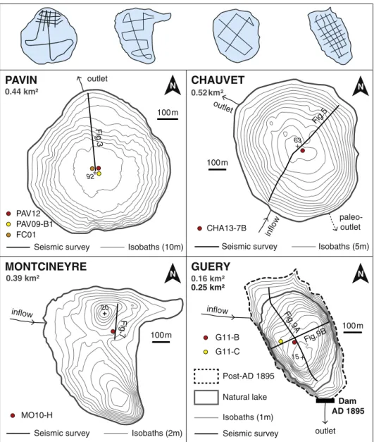
100 m inflow Dam AD 1895 100 m inflow 100 m inflo w outlet outlet outlet 100 m N N N N
CHAUVET
MONTCINEYRE
GUERY
PAVIN
Post-AD 1895 Natural lake Seismic survey Seismic survey Isobaths (1m) G11-C Isobaths (2m) G11-BSeismic survey Isobaths (5m) CHA13-7B
Seismic survey Isobaths (10m) PAV09-B1 MO10-H 0.44 km² 0.16 km² 0.25 km² 0.52 km² 0.39 km² paleo-outlet PAV12 FC01 Fig .3 Fig.5 F ig.7 Fig .9A Fig.9B 20 63 15 92
Fig. 2. Navigation grids for hydroacoustic surveys (Chapron et al., 2012) and bathymetric maps of lakes Pavin, Chauvet, Montcineyre and Guéry with cores and seismic surveys illustrated in correspondingfigures. Crosses indicate the deepest points.
Age–depth models of cores MO10-H and G11-B were performed using organic debris (Table 2). The top-core chronology of core G11-B was also improved with the identification of a major shift in the sedimentary dynamic, likely connected to the dam construction in AD 1895.
4. Results 4.1. Lake Pavin
Formed ca. 7000 years ago (Juvigné et al., 1996; Chapron et al., 2010), Lake Pavin presently dwells in a former maar resulting from a phreato-magmatic explosion (Fig. 2,Table 1). Consequently, its shape is almost circular (0.44 km2) with a diameter of 700 m and a maximum water depth of 92 m in the central basin. Inner slopes of the topographic catchment area (0.36 km2) are very steep and enhance the runoff of
rainwater along with multiple streams located around the lake. Previous work described the presence of (1) annually deposited diatomaceous sediment (i.e., diatomite) (Schettler et al., 2007; Chapron et al., 2010, 2012); (2) sedimentary events recording past extreme environmental changes, including a crater rim break with a lake outburst and the re-cord of a mass-wasting deposit in the sedimentary rere-cord in AD 600;
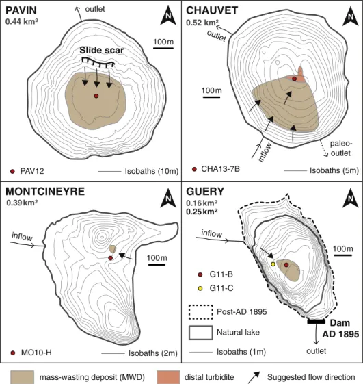
and (3) a large slope failure around AD 1300 and recurrent turbidites in the XIXthcentury (Chassiot et al., 2016) (Fig. 3). As previously
described inChapron et al. (2010, 2012), the gas-rich sediment in the lake bottom precludes the penetration of acoustic waves (with sources of either 3.5 or 12 kHz) (Fig. 3). Nevertheless, a recent coring campaign collected a composite sequence (PAV12) that covers the sedimentary evolution since the formation of the lake (Fig. 4A). From top to bottom, core PAV12 displays four main lithozones with (1) an upper diatomite unit (0–207 cm depth); (2) a package of various massive units (i.e., a light green unit, tilted lamina, a dark green unit, a dark brown unit and a patchwork of disrupted diatomite); (3) a lower diatomite unit; and (4) a basal grey unit made of lamina interrupted by massive units displaying coarse bases andfining-upward sequences (Chassiot et al., 2016). The transition from the upper diatomite to the light green unit is highlighted by major changes in the FDS spectral map suggesting dras-tic changes in sediment composition. Through the upper 2 m-length diatomite unit, the TOC content varies from 4 to 9%.The organic petrogra-phy indicates an algal-dominated organic sedimentation (Fig. 4A). In the 70 cm thick light green unit, grain-size analyses indicate a silty to sandy sediment (Fig. 4A). Textural parameters display a low mean grain-size value (21.19 ± 3.96μm), very poorly sorted (4.40 ± 0.44) with highly variable values in skewness (0.08 ± 0.08) and kurtosis (0.96 ± 0.05)
Slide scar
N 100 m 20 40 60 80 Depth (m) 100 0?
N S In-situ diatomite Slide scar Littoral deposit 50 m PAV12 Gas-rich sediments Substratum AD 600 MWD FC01 PAV09-B1Fig. 3. 12 kHz acoustic subbottom profile of a North–South transect across Lake Pavin (Fig. 2) with PAV12 core location (afterChapron et al., 2012). The colored image on the upper-left corner is a zoom of a multibeam bathymetric map showing the slide scar clipping the edge of the plateau (afterChapron et al., 2010, Chassiot et al., 2016). On the acoustic profile, this scar affects in-situ diatomite and former AD 600 Mass-Wasting Deposit deposited on the plateau. (For interpretation of the references to color in thisfigure legend, the reader is referred to the web version of this article.)
Table 2
Radiocarbon dating samples references with conventional ages (BP) obtained by AMS radiocarbon dating. Conventional ages (BP) have been computed into the CLAM software (Blaauw, 2010) to generate age–depth models. The two-sigma calibration has been made using the Intcal13 curve (Reimer et al., 2013). Numbers in parentheses indicate the probability. Asterisks refer to a radiocarbon plateau.
Lake Core Depth Laboratory reference Material Conventional age (BP)
Two sigma calibration (cal. BP)
Pavin PAV09-B1 96.5 cm Poz-33126 Leaf 150 ± 30 200 ± 30 (0.33)*
PAV12 137 cm Lyon-10961 Leaf 220 ± 30 285 ± 20 (0.40)*
Chauvet CHA13-7B 16.5 cm Beta-409402 Gyttja 680 ± 30 660 ± 20 (0.64)*
30 cm Beta-409403 Gyttja 790 ± 30 710 ± 40 (1)
51.5 cm Beta-409404 Gyttja 1170 ± 30 1115 ± 65 (0.85)
83 cm Beta-362775 Leaf 2360 ± 30 2400 ± 70 (0.99)
Montcineyre MO10-H 16.5 cm UCIAMS-92405 Leaf 485 ± 15 520 ± 15 (1)
86.5 cm UCIAMS-92408 Leaf 735 ± 15 675 ± 10 (1)
Guéry G11-B 52 cm Beta-320655 Leaf 110 ± 30 80 ± 70 (0.69)*
parameters (Fig. 4B). The skewness vs. sorting plot clearly separates the top and the base of the light green unit identified at the top of the MWD in core PAV12 (Fig. 4B). Across these units, the bottom (B) to top (T) path shows a decrease in sorting values along with an increase in skewness values. However, one can notice the base-to-top evolution in the skew-ness vs. sorting plot does not follow a straight path (Fig. 4B).
4.2. Lake Chauvet
Twin of Lake Pavin, Lake Chauvet (0.52 km2) is a 63 m deep maar
lake located at the southern boundary of the Mont Dore province (Fig. 2,Table 1).Juvigné (1992)demonstrated its phreato-magmatic origin, despite the absence of a crater rim. According to this author, this can be explained by the overlying ice cap that disturbed the ejection of volcanic materials when the explosion occurred during the late Pleistocene. Indeed, the presence of moraines at its southern side
indicates a former lake outlet downstream the glacier advance from the Puy-de-Sancy (Juvigné, 1992) (Fig. 2). This hypothesis has then been confirmed by acoustic profiles (12 kHz) illustrating subaquatic moraines separating several sedimentary basins across the lake (Chapron et al., 2012) (Fig. 5). The acoustic image across Lake Chauvet illustrates a global bowl-shaped morphology, typical of a maar lake, with steep slopes from the littoral to the lake bottom (Fig. 5). The deepest part of the lake shows a succession of small sedimentary basins separated by a moraine ridge (Chapron et al., 2012). On the southwest-ern side, in the continuity of the river inflow, the acoustic facies displays chaotic packages of sediments. Within the deep basins, the sedimentary infill has developed a stratified acoustic facies with several high ampli-tude and continuous reflections. The entire sedimentary sequence did not exceed 6 m thick at core site (Fig. 6).
In the deep basin, one coring campaign allowed retrieving a 95 cm long gravity core CHA13-7B (Fig. 6). From top to bottom, core CHA13-0 14 12 10 8 6 4 2 Depth (m) PAV12 CHRONOLOGY Calendar age 0 0.2 0.4 0.6 0.8 2000 1800 1600 1400 1200 kyrs (cal BP) calendar age(AD) MWD Max 0.314 Min - 0.251 d405 FDS d695 Spectral Map 0 5 10 TOC (%) terrigenous OM algal OM
Silty flow deposit AD 1280 ± 20
Grain size (%) 0 50 100 sands silts clays
Palyno facies
In-situ diatomite Light green unit
Dark green unit Dark brown unit
Grey unit Disturbed diatomite LITHOLOGY Top-core Leaves 0.5m 1m 1.5m 2m 2.5m 100200 400 0m 300 FC01 varve counting 180 190 200 210 220 230 240 250 260 Depth (cm) PAV12 270 10 20 30 40 3 4 5 6 -0.1 0.1 0.3 0.8 0.9 1 1.1 Mean (µm) Sorting Skewness Kurtosis Top Base
B
A
Base Top 3 4 5 6 0.30 0.20 0.10 0 - 0.10 Sorting B T SkewnessFig. 4. (A) Multi-proxy analyses and age–depth model for the top core of PAV12 (afterChassiot et al., 2016). Additional grain-size analyses are provided for the light green unit at the summit of the plurimetric Mass-Wasting Deposit. (B) Textural parameters and skewness vs. sorting diagram for the light green unit in core PAV12. The base-to-top evolution is indicated by a red line. (For interpretation of the references to color in thisfigure legend, the reader is referred to the web version of this article.)
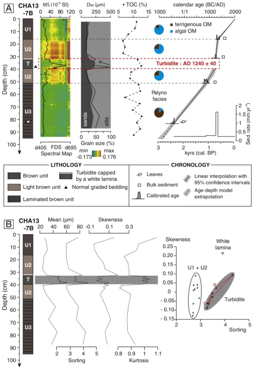
7B exhibits a brown unit (U1, 0–16.5 cm depth), a light brown unit (U2a, 16.5–32.5 cm depth), a greenish homogeneous unit with a sandy base capped by a with lamina (T, 32.5–39.5 cm depth), a second light brown unit (U2b, 39.5–50.5 cm depth) and a laminated dark brown unit (U3, 50.5–95 cm depth). At the top core, units U1 and U2 are characterized by low to medium MS values and an organic content between 5 and 10% of TOC. Organic petrography confirms the abundance of algal organic matter throughout these two units. At the bottom of the core, the laminated unit U3 displays afluctuating but elevated TOC content, mostly over 10%, whose organic fraction is essen-tially composed of terrigenous supplies. The greenish homogeneous unit is characterized by a normal grading underlined by a peak in both D90parameter and MS values (Fig. 6A). In contrast to units U1 and U2,
this unit also displays high mean grain-size values (49.48 ± 5.62μm), very poorly sorted (3.55 ± 0.37) with highly variable values in skew-ness (−0.02 ± 0.06) and kurtosis (1.01 ± 0.02) parameters (Fig. 6B). Above this unit, the white lamina displays a very high skewness value without increase in clay content. In the skewness/sorting diagram, the base-to-top evolution indicates a decreasing trend in both sorting and skewness values (Fig. 6B).
4.3. Lake Montcineyre
Shortly before the Pavin crater explosion, ca. 7500 years ago, the growth of the Montcineyre volcano dammed the valley where a small river wasflowing (Juvigné et al., 1996). Nowadays, the resulting Lake Montcineyre (0.39 km2) is a 20 m water depth basin with a crescent
shape (Fig. 2,Table 1). As illustrated in the bathymetric map, the pres-ence of two round-shaped lacustrine basins suggests probable former maars settled below the current lake. Acoustic images (12 kHz) display a reduced accumulation of sediments, with a maximum thickness of 4 m. Seismic profiles illustrate the development of a lacustrine drape characterized by few low amplitude but continuous reflections along with a transparent and chaotic lens capped by a thick reflector labeled R1 inFig. 7(Chapron et al., 2012).
The core MO10-H illustrates the sedimentary infill in this northern basin. The spectral map allows to identify three sedimentary units along the core (Fig. 8). At the top-core, the brownish unit U1 (0– 16.5 cm depth) exhibits organic-rich sediments with 10% of TOC and elevated MS values. The OM fraction is made of a mix of terrestrial and algal material. Unit U2 (16.5–66 cm depth) shows decreasing MS
values with depth and a slight decrease in organic content, dominated by terrigenous inputs of OM. This unit is separated from the unit U3 by a peak in MS at 66 cm depth. The down-core is characterized by the presence of an algal bloom layer with elevated TOC content. Within this unit, the presence of algal matter has been confirmed by palynofacies observation (Fig. 8). The seismic-to-core correlation un-derlines the correspondence between the MS peak at 66 cm depth and the reflector R1 identified on the seismic profile (Fig. 7).
4.4. Lake Guéry
Located at 1244 m a.s.l. on a basaltic plateau, Lake Guéry is the highest lake in the Mont Dore massif and drains a 6.5 km2catchment
area by a river on its west slope. To produce hydroelectricity, the con-struction of the dam in AD 1895 increased the lake-level to 5 m above its natural level. In consequence, the present-day lake surface reaches 0.26 km2for a maximum water depth near 20 m (Fig. 2,Table 1). Within
the lake, two acoustic surveys (4 and 14 kHz source) display only gas-rich sediments that precluded acoustic penetration and therefore impeded the observation of sedimentary units below the lakefloor (Fig. 9).
Despite this lack of information, two short gravity cores collected in the central basin document the recent sedimentaryfill. The multi-proxy approach reveals massive brownish sediments without visible sedi-mentary units (Fig. 12). Along core G11-B, the TOC content remains constant (9–10%) and the organic fraction is dominated by terrigenous inputs throughout (Fig. 10). However, the X-rays analyses exhibit vari-ous features allowing us to unravel six sedimentary units within core G11-B (units B) andfive within core G11-C (units C) (Fig. 10). These units are characterized by three main X-rays facies: (1) a homogeneous facies associated with high MS values in the top-cores (unit B1 between 0 and 1.5 cm depth and unit C1 between 0 and 6.5 cm depth); (2) faintly laminated facies (units B3, B5, C3 and C5) interrupted by (3) disturbed facies characterized by lenses and chaotic features. Three disturbed facies have been counted along core G11-B. From top to base, unit B2 (1.5–8.5 cm depth) shows chaotic lenses. At 13 cm depth, unit B4 (13–37 cm depth) displays a base underlined by elevated MS values. At the bottom of the core, unit B6 (100–123 cm depth) is characterized by low grey-levels and sedimentary disturbances on the X-rays facies. Core-to-core correlation links units B2 and B4 to units C2 and C4 identi-fied in core G11-C, respectively.
Lacustrine
drape
MWD
Substratum
NE
SW
- 60 m - 70 mCHA13-7B
Depth (m) 20 30 40 50 60 70BASIN
Moraine ridges
50 m
0 10Turbidite
Reworked
sediments
Fig. 5. 12 kHz acoustic subbottom profile of a Northeast-Southwest transect across Lake Chauvet (Fig. 2) with CHA13-7B core location (afterChapron et al., 2012). The zoom illustrates the basinfill geometries between moraines ridges with reworked sediment (Mass-Wasting Deposit) at the downslope and laminated facies in the distal part of the sub-basin.
5. Discussion
5.1. Signatures and hydrodynamic processes of sedimentary events Investigations in volcanic lakes of the Mont Dore province underline the presence of several types of sedimentary events reflecting the rupture initiation and the hydraulic energy deployed during the trans-port and sedimentation (Mulder and Cochonat, 1996; Campos et al., 2014). The best examples of these processes are the contrasting textural signatures between sedimentary events identified in cores PAV12 (Fig. 4B) and CHA13-7B (Fig. 6B).
Following the classification ofMulder and Cochonat (1996), textural parameters of the green light unit identified in core PAV12 indicate a silty liquefied flow deposit and correspond to the top of the 4 m thick
MWD originating of the slope scar mapped at the edge of the plateau (Chapron et al., 2010) (Fig. 3). From base to top, the textural evolution of the silty liquefied flow deposit (Fig. 4B) do not support a reducing energy, as the skewness values remain high during the deposition of the top of this unit (Bertrand et al., 2008). The chaotic evolution suggestsfluctuations in the depositional dynamic (Campos et al., 2014). In a maar like Lake Pavin, this chaotic evolution could be the con-sequence of a prolonged motion of the water column impeding a fine-grained homogeneous suspension. In a recent study,Chassiot et al. (2016)connected this silty liquefied flow deposit to the collapse of the edge of the plateau (Fig. 3). Constrained in a deep flat basin surrounded by steep walls, theflow resulting from this collapse may have not been transported over a long distance, but likely reflected on the southern side. Therefore, the bowl-shaped morphology of Lake
CHA13 -7B 0 80 70 60 50 40 30 20 10 100 90 Depth (cm) U2 U1 U2 U3 T Bulk sediment
Leaves Linear interpolation with 95% confidence intervals Calibrated age Age-depth model extrapolation Turbidite : AD 1240 ± 40 kyrs (cal. BP) calendar age (BC/AD)
2000 1000 1000 1/1 0 1.5 1 0.5 2 0 3 2 1 Se d405 FDS d695 Spectral Map 0 40 80 120 SI) 5 10 15 TOC (%) Grain size (%) 0 50 100 0 250 500
Normal graded bedding Turbidite capped by a white lamina Brown unit
Light brown unit Laminated brown unit
LITHOLOGY CHRONOLOGY terrigenous OM algal OM max 0.176 min -0.173 Palyno facies sands silts 0 80 70 60 50 40 30 20 10 100 90 Depth (cm) 0.25 0.20 0.15 0.10 0.05 0 - 0.05 - 0.10 - 0.15 2 3 4 5 Skewness Sorting B T Turbidite U1 + U2 White lamina U2 U1 U2 U3 T 20 40 60 80 2 3 4 5 -0.1 0.1 0.3 0.8 0.9 1 1.1 Mean (µm) Sorting Skewness Kurtosis
B
CHA13-7BA
Fig. 6. Multi-proxy analyses and age–depth model for core CHA13-7B. Grain-size measures underline the presence of a turbidite with a sandy base and capped by a white clayey lamina. (B) Textural parameters and skewness vs. sorting diagram for the unit T in core CHA13-7B. The base-to-top evolution is indicated by a red line. (For interpretation of the references to color in thisfigure legend, the reader is referred to the web version of this article.)
Pavin, in contrast to large alpine lakes or marine environments, may explain the chaotic base-to-top evolution in the textural parameters of this deposit (Fig. 4B).
The volume of reworked sediment can be roughly estimated consid-ering the deepflat basin as the sedimentation surface (80,000 m2
) (Fig. 11). The total thickness of the MWD exceeds 4 m in core PAV12 (Chassiot et al., 2016) (Fig. 3). The maximum volume of reworked sed-iment can thus be estimated to 320,000 m3. Among this volume,
56,000 m3may correspond to the 70 cm thick silty deposit identified
at the top of the MWD. In core CHA13-7B, the sandy base and thefining upward sequence identified in unit T, in addition to a white lamina at its top, constitute evidences for a sedimentary event deposited during one short-term episode of turbidity current (i.e., turbidite, e.g.,St-Onge et al., 2004; Strasser et al., 2013). The base-to-top decrease in sorting and
skewness values indicates a decreasing energy during deposition at core site (Fig. 6B). According to acoustic images accuracy in the vertical resolution (±10 cm), this turbidite could match the reflector identified just below the lakefloor (Fig. 5). In addition, its position downslope from the reworked sediment may reflect the evolution in the transport mode of one single event, from a proximal debrisflow on the slopes to a distal low-density turbidity current in the deep basin (Fig. 5). Therefore, a transport by suspension during a turbulentflow was probably initiat-ed downslope after the failure of slope sinitiat-ediments. Unlike Lake Pavin, gentler slopes combined to a greater distance from the failure area may explain this signature in textural parameters, with a fining-upward sequence deposited during a reducing unidirectional turbulent flow at core CHA13-7B location. However, the absence of clay enrich-ment in the white lamina does not relate it to a fine-grained
Reflector R1 (MWD) MO10-H Multiple Substratum Gas pockets Chaotic lens Depth (m) 20 15 5 10 0 25 m S N
Fig. 7. 12 kHz acoustic subbottom profile of a North–South transect across the northern sub-basin of Lake Montcineyre (Fig. 2) with MO10-H core location (afterChapron et al., 2012). The transparent to chaotic lens reflects a Mass-Wasting Deposit, here capped by a high amplitude reflector labeled R1.
TOC (%) 2000 0 5 4 3 2 1 Sed . rate ( ) 1800 1600 1400 1200 0 200 400 600 800 yrs cal BP calendar age (AD)
Reflector R1 AD 1320 ± 30 Palyno facies 0 80 70 60 50 40 30 20 10 90 Depth (cm) MO10-H 0 204060 80 d405 d695 FDS Spectral Map 5 10 15 terrigenous OM algal OM U1 U2 U3 max 0.067 min -0.030 Brown unit Light brown unit Algal bloom
LITHOLOGY CHRONOLOGY
Leaves
Linear interpolation with 95% confidence intervals Calibrated age
Fig. 8. Multi-proxy analyses and age–depth model for core MO10-H. The red dashed line corresponds to the reflector R1 according to the seismic-to-core correlation. Shaded area represents the vertical scale incertitude due to the accuracy of acoustic profiles in vertical scale (±10 cm). (For interpretation of the references to color in this figure legend, the reader is referred to the web version of this article.)
homogenous suspension, but likely to a diatom bloom in response to en-hanced nutrient inputs in the deep basin during the turbulentflow. The acoustic profiles performed in the southwestern side indicate a 1.5 m-thick chaotic facies corresponding to reworked sediment on the axis of the inflow (Fig. 5). This facies has been mapped on a large area along the southwestern side of the lake, suggesting a large volume (150,000 m3) of reworked sediments (Fig. 11).
In Lake Montcineyre, only one acoustic image displays a 50-m long chaotic lens, an acoustic feature frequently associated with reworked sediments aggregated into a Mass-Wasting Deposit (MWD, e.g.,Moernaut et al., 2007). This suggests a small volume of sediment with a limited extension within the basin. According to the bathymetric map, source areas probably correspond to the steepflanks of the Montcineyre volcano, east side of the lake (Fig. 11).
In Lake Guéry, the X-rays radiographies highlight disturbed facies with lenses and chaotic features that reflect sediments deposited down-slope after gravity reworking processes (MWD, e.g.,Beck, 2009). The absence of acoustic penetration below lakefloor prevents to estimate the geometry of these deposits, but the steep slopes on the northwest-ern side of the lake, in the axis of the river inflow, may correspond to the source area for MWDs identified in the deep basin (Fig. 11). 5.2. Chronology of sedimentary events
As detailed inChassiot et al. (2016), we assume a uniform diatoma-ceous sedimentation across the deep flat basin of Lake Pavin to
constrain the age of the silty liquefied flow deposit identified in core PAV12. Therefore, the revised varve counting performed on core FC01 (Stebich et al., 2005; Schettler et al., 2007) has been translated to PAV12 (Fig. 2). Moreover, two radiocarbon dates on leaf debris sampled in piston core PAV12 and nearby gravity-core PAV09-B1 (Fig. 2,Table 2) match the varve chronology and thus support the age of the silty lique-fied flow deposit, here estimated to ca. cal. AD 1280 ± 20 (Chassiot et al., 2016).
In core CHA13-7B, the predominance of algal-derived compounds (75–85%) in the organic fraction of units U1 and U2 (Fig. 6) suggests a negligible“old carbon” effect. Calibrated radiocarbon ages of the three bulk sediments sampled within these units (Table 1) thus ap-pears in order to compute an age–depth model. With this method, the turbidite identified within unit U2 has been dated to cal. AD 1240 ± 40 (Fig. 6).
In core MO10-H, the age–depth model displays a high sedimentation rate during the deposition of the reflector R1. This reflector has been dated to cal. AD 1320 ± 30 (Fig. 8), considering uncertainty of 10 cm in the vertical resolution of the seismic profile. Thereby, a similar age can be inferred for the MWD identified downslope and capped by this reflector (Fig. 7).
In cores G11-B and G11-C, we assume the onset of homogeneous units at top-cores is connected to the lake-level rise after dam construc-tion in AD 1895 (Fig. 10). Thereafter, this chronological information has been used to constrain the chronology of the upper units. In addition of two AMS radiocarbon dating sampled in laminated sediments of G11-B 0 15 10 5 Depth (m) G11-C 0 15 10 5 Depth (m) G11-B WSW ENE 20 20 Gas-rich sediment Gas-rich sediment Multiple Multiple Multiple 50 m
A
B
50 m NW SE + 5 m + 5 m AD 1895 Today AD 1895 TodayFig. 9. 4 kHz (A) and 14 kHz (B) acoustic subbottom profiles for longitudinal (A) and transversal (B) transects across Lake Guéry, illustrating the gas-rich sediment all over the basin, precluding the observation of sedimentary infill geometry.
(Table 2), we computed an age–depth model once the MWD removed. From top to base, the ages of MWDs have been estimated to cal. AD 1895 (B2 and C2), cal. AD 1860 ± 40 (B4 and C4) and cal. AD 1300 ± 250 (B6). The later has been calculated by extrapolating the age–depth model and the 95% confidence intervals (Fig. 10).
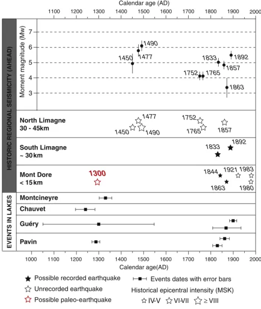
Within the four lakes, a series of 6 sedimentary events has been dated over the last 700 years. In addition to the 2 earthquake-triggered turbidites identified in Lake Pavin sedimentary record (Chassiot et al., 2016), this total increases to 8 sedimentary events occurring within the area for the last millennium. Their occurrence in time highlights the late XIIIthand the XIXthcenturies as two periods
with synchronous events in at least two lakes (Fig. 12). 5.3. Triggering factors of sedimentary events
In lacustrine environments, sedimentary events such as MWD and/or turbidite can be triggered by sediment overloading, lake-levelfluctuations, waves, snow avalanches, rock falls, gas discharge or earthquakes (e.g.,Monecke et al., 2004; Girardclos et al., 2007; Strasser et al., 2013). The following slope failure will cause a gravity-driven transport of reworked material. Usually, the good matching between sedimentary events in lakes and an historical earthquake in the vicinity increases the likelihood for earthquake-triggered deposits, but this method is often limited by the avail-ability and the accuracy of historical reports that rarely goes beyond the last millennium. In Holocene records, the occurrence of synchronous deposits in disconnected basins is a recognized ar-gument for widespread triggering mechanisms such as earthquakes
(e.g.,Strasser et al., 2013; Moernaut et al., 2014; Pouderoux et al., 2014; Chapron et al., 2016). However, the use of lacustrine archives remains limited by the ability of lake sediments to record earth-quakes. When a tectonic event occurs, both magnitude and lake-epicenter distance have to be considered in the generation of slope failures and the following deposition of mass-movement de-posits. On the one hand, the increasing lake-epicenter distance tends to reduce the lake sensitivity to earthquakes (Moernaut et al., 2007). On the other hand, the more the magnitude increases, the more the lake will be sensitive to seismic ground motion. How-ever, this concept is highly dependent of seismic wave propagation within the studied area, which can be amplified by topographic effect in mountain ranges.
5.4. Human-induced and earthquake-triggered deposits in the XIXth
century
The spatio-temporal distribution of sedimentary events in lakes highlights the late XIXthcentury as a period with four events identified
in two lakes (Fig. 12). Two turbidites have been previously inventoried in the deep basin of Lake Pavin (AD 1825 ± 20 and AD 1860 ± 20, see
Chassiot et al., 2016for details), in addition to two MWDs identified in Lake Guéry (AD 1866 ± 40 and likely AD 1895). At this site, the most recent MWD has been attributed to the lake-level rise following the dam construction on the basis of two clues. First, the onset of a homogenous sedimentary unit above this MWD must reflect a drastic environmental change probably induced by the increase of water depth (+50%) and lake surface (+56%). Second, change in pore-fluid
G11-B 0 80 70 60 50 40 30 20 10 100 90 Depth (cm) 110 120 130 0 50 100 150 5 10 15 TOC (%) FDS Spectral Map d405 d695 G11-C max 0.114 min -0.032 FDS min max Density C1 C2 C3 C4 C5 B4 B5 B6 B3 B2 B1 0 200 400 600 800 yrs cal BP MWD : AD 1866 ± 40 MWD : dam construction AD 1895 Mont-Dore AD 1863 MWD : AD 1300 ± 250 Palyno facies terrigenous OM algal OM 2000 1800 1600 1400 1200
calendar age (AD)
Homogenous facies
Laminated facies
Disturbed facies with lenses and fluidization features
Linear interpolation with 95% confidence intervals CHRONOLOGY Age-depth model extrapolation Calendar age Leaves RADIOGRAPHY 0 3 2 1 S e d. rate ( ) B4 C2 B5 B1
Fig. 10. Multi-proxy analyses and age–depth model for core G11-B. The dashed lines delimitate the Mass-Wasting Deposits identified on the X-rays core scanning through disturbed facies with lenses andfluidization features. The upper MWD has been attributed to the dam construction in AD 1895 followed by a rapid lake-level increase (+5 m) that probably drives the shift observed on X-rays facies in the top-cores (B1 and C1).
pressure induced by such an abrupt lake-levelfluctuation is a recog-nized trigger for slope failure and subsequent sedimentary units desta-bilization (Anselmetti et al., 2009). The events dated AD 1860 ± 20 (Lake Pavin) and AD 1866 ± 40 (Lake Guéry) gather into the same time window and thus may coincide with the occurrence of the 1863 earthquake located at Mont Dore (Fig. 1B). The proximity of its epicen-ter compared to both lakes (b10 km) may indicate a common tectonic trigger for these two sedimentary events, despite a weak moment of magnitude (Mw = 3.38 ± 0.62 afterStucchi et al., 2013) (Fig. 12). The occurrence of a larger earthquake in AD 1892 (Mw = 5.50 ± 30 and Io = VII) only 30 km east in the South Limagne fault can also be an alternative for triggering subaquatic landslides in the Mont Dore region (Chassiot et al., 2016) (Fig. 1B). Similarly, the turbidite dated cal. AD 1825 ± 20 in Lake Pavin is expected to have been triggered by a tectonic event, but there again, the accuracy in the age–depth model precludes to define a single source, as the recurrence time of earth-quakes during this period was very short. For this event, potential can-didates could be either the AD 1844 (unknown Mw and Io = V½) or the AD 1833 (Mw = 5.04 ± 0.30 and Io = VII) seismic events that oc-curred at Chambon-sur-lac (b15 km) and Issoire (30 km), respectively (Fig. 12). In the same manner, the event occurring below the Chaîne-des-Puys in AD 1857 (Mw = 4.86 ± 0.30 and Io = V½) could match one of the previously mentioned events, but the lake-epicenter distance is much farther (N30 km) by comparison with other similar events reported in the XIXthcentury.
5.5. Lacustrine records of an undocumented paleo-earthquake around AD 1300
Further back in time, four deposits have been identified within lakes Pavin, Guéry, Chauvet and Montcineyre (Fig. 11). Exception made of the one dated in lake Guéry with an extrapolation of the age–depth model, the dating accuracy provides reliable chronological constrains about their synchronicity during the late XIIIthcentury or the early XIVth
cen-tury (Fig. 12). However, no seismic activity neither in AHEAD database (Stucchi et al., 2013) nor in other historical documents (Lambert et al., 1997) has been reported during this medieval period. Despite this fact, the gathering of these events around AD 1300 suggests a common re-gional trigger. The likelihood for a tectonic triggering is therefore very high for this event identified in disconnected basins over a large area.
In the absence of historical reports about this event, a large earth-quake like those documented near the Limagne fault is unlikely. How-ever, a weaker paleo-earthquake such as the AD 1863 in Mont Dore event could be a possibility. To support this hypothesis, recent archeo-logical investigations on the neighboring Murol castle (Fig. 1B) have re-vealed failures and collapses estimated to the late XIIIthcentury (Allios, 2015). The temporal distribution of seismic events in the area does not display single events for the last millennium, but clusters of tectonic events occurring in short time windows (Fig. 12). Consequently, the occurrence of synchronous MWDs in disconnected basins as it was in AD 1300 highly suggests a (cluster of) regional earthquake(s) as a
100 m inflow
Dam
AD 1895
100 m inflow 100 m inflo w outlet outlet outlet 100 m N N N NCHAUVET
MONTCINEYRE
GUERY
PAVIN
Post-AD 1895 Natural lake Isobaths (1m) G11-C Isobaths (2m) G11-B Isobaths (5m) CHA13-7B Isobaths (10m) MO10-H 0.44 km² 0.16 km² 0.25 km² 0.52 km² 0.39 km² paleo-outlet PAV12Slide scar
Suggested flow direction distal turbidite
mass-wasting deposit (MWD)
trigger for simultaneous slope failures in lakes Pavin, Guéry, Chauvet and Montcineyre.
Chassiot et al. (2016)evaluated Lake Pavin sensitivity to earth-quakes and suggested this lake can record earthearth-quakes with epicentral intensity of V in a radius of 15 km. This maximum lake-epicenter dis-tance has been coupled to the radial disdis-tance between Lake Guéry and the AD 1863 earthquake epicenter to define an area where the AD 1300 earthquake epicenter must have been situated (Fig. 13). Within this seismogenic area, this epicenter location is supported by the occur-rence of earthquakes during the XIXthcentury and the absence of
earthquake-induced deposits along a SW–NE transect in lakes Aydat (Lavrieux et al., 2013), Chambon (Macaire et al., 1997) and Crégut (Chassiot, 2015). Further investigations on nearby maar lakes Servières and La Godivelle-d'en-Haut (Bastin et al., 1991; Juvigné, 1992) may greatly improve the scope of this medieval event.
5.6. Lake sensitivity to earthquakes
Apart from the external parameters related to the tectonic event (i.e., magnitude, intensity and lake-epicenter distance), lake sensitivity to earthquakes is a function of several morphological, sedimentological and limnological parameters that play a key-role in sediment stability. These parameters are reviewed thereafter, with the aim to explain the specificities of each lake in our setting.
In thefirst case, lake morphology is assumed to be the primary parameter, as sediments settled on steep slopes are more susceptible to be driven by gravity reworking processes than sediments buried in flat basins. In volcanic regions, the lacustrine morphology is mainly associated with lake origin. The bowl-shaped maar lakes display high depth–area ratios with steep slopes (Anselmetti et al., 2009; Chapron et al., 2010; Chassiot et al., 2016) as opposed to volcanic-dam lakes which generally have gentler slopes (Lavrieux et al., 2013) (Table 1,
Fig. 2). Such contrast in the geomorphological setting between lakes may explain the large MWD and its associated distal turbidite identified across the Lake Chauvet in AD 1300 (Figs. 5 and 6), as well as the syn-chronous large slope failure and the associated slump in the deep basin of Lake Pavin (Figs. 3 and 4). Similarly, the thin turbidites described in the basin during the XIXthcentury probably would have not been recorded in another geomorphological context (Chassiot et al., 2016).
The nature of sediment has also to be considered during a seismic shaking. Fine-grained but organic-rich sediments have been reported in the four studied lakes. During sedimentation, the burial of organic matter may lead to the accumulation of gas within the sedimentary units, as observed in the deep basins of Lake Pavin and across Lake Guéry (Figs. 3and9). In such a context, the earthquake shaking may alter the sediment stability by a sudden gas release associated with flu-idization features and thus favoring the generation of MWDs (Chapron
Moment magnitude (Mw) 1000 1100 1200 1300 1400 1500 1600 1700 1800 1900 2000 Calendar age(AD) Montcineyre Chauvet Guéry Pavin
HISTORIC REGIONAL SEISMICITY (AHEAD)
EVENTS IN LAKES North Limagne 30 - 45 km South Limagne ~ 30 km Mont Dore < 15 km 1980 1983 1921 1863 1857 1844 1833 1892
IV-V
VI-VII ≥ VIII1490 1450
1477
Historical epicentral intensity (MSK)
Possible recorded earthquake Events dates with error bars
Unrecorded earthquake Possible paleo-earthquake
1300
7 6 5 4 1100 1200 1300 1400 1500 1600 1700 1800 1900Calendar age (AD)
1752 1765 3 1450 1477 1490 1752 1765 1863 1833 1892 1857 2000
Fig. 12. Temporal distribution of sedimentary events in lakes Pavin, Chauvet, Montcineyre and Guéry along with historical regional seismicity inferred from AHEAD database (Stucchi et al., 2013). Additional data are taken fromChassiot et al. (2016). Epicenters are presented according to their intensity, their moment magnitude (Mw) and their distance to lakes.
et al., 2004; Moernaut et al., 2007). In the specific setting of Lake Pavin, the dominant in-situ diatomaceous sedimentation develops unconsoli-dated material draping steep slopes that can also be remobilized during tectonic events (Chassiot et al., 2016).
Lake-levelfluctuations can also modify the interstitial water pres-sure within the sedimentary units and thus alter sediment stability. Variations in lake-level can be a function of the hydrological balance (Precipitation/Evaporation ratio) under climatic forcing over long periods (Anselmetti et al., 2009). In Lake Pavin, the former lake drainage by the failure of the crater rim in AD 600 led to an abrupt drawdown of ca. 9 m that may have substantially enhanced its capacity to record the subsequent earthquakes (Chassiot et al., 2016).
Finally, high sediment load may also favor the occurrence of slope failure in large and small lakes (Girardclos et al., 2007; Wilhelm et al., 2015). Despite the absence of significant deltas in the small lakes across the Mont Dore, an increase in sedimentfluxes may lead to local sedi-ment overload on the slopes which can, in case of a seismic event, slide to generate MWDs downstream. In nearby lakes Montcineyre and Chauvet, an increase in sedimentation rates at the time where the MWDs occurred (Figs. 6 and 8) can be noticed. Across these two lakes, age–depth models highlight the medieval times (ca. AD 850–AD 1400) as a period with high sedimentation rates, probably in relation with increased human activities in the catchment, as attested by other studies in close Lake Aydat (Lavrieux et al., 2013). Likewise, in Lake Guéry, the permanent river drains a relatively large catchment area and feed the lake with terrestrial supplies. There again, the increase in the sedimentation rates at G11-B site in Lake Guéry may reflect a
human-induced increased runoff in the catchment since the early XIXthcentury that may have favored the recording of the AD 1863
event (Fig. 10). Recent studies focusing on alpine lakes pinpoint sedi-mentation patterns as important factors controlling the lake sensitivity to earthquakes, mainly controlled by climate-induced major environ-mental changes over the Holocene (Chapron et al., 2016). In contrast, the Mont Dore province exhibits two examples (i.e., Lake Montcineyre and Lake Chauvet) of human-induced changes in sedimentation rates. In these cases, it seems that the human impact on soil erosion during medieval times greatly increased the sediment load, which favored the formation of unconsolidated sediment removed during a regional seismic shaking near AD 1300. The decrease in the sedimentation rate observed in these two systems at the beginning of the XVthcentury,
probably driven by land-use evolution within catchments, may explain the lack of earthquake-induced deposits during the XIXthcentury. On
the contrary, Lake Pavin and Lake Guéry display higher sedimentation rates which can facilitate the record of subsequent earthquakes at this period.
In consequence, lake sensitivity to earthquakes is a combination of external (i.e., related to the tectonic event) and internal (i.e., specific to each lake) factors. Moreover, lake sensitivity to earthquakes can be pictured as an evolving concept over time. Because lake sensitivity can be significantly altered by short-term human impact and/or long-term climaticfluctuations in sedimentary load, these two factors need to be considered for future perspectives focusing on these natural seismo-graphs, which have major implications for paleoseismology and seismic hazard assessment.
M
Cv
Cb
A
Gr
P
Gd
N
10 km
1980
1921
1863
1892
1833
1892
1833
1844
Cr
Sv
AD 1300 earthquake-triggered deposits No evidence for AD 1300 earthquakeNo information AD 1300 Earthquake epicenter?
Lake Pavin sensitivity to earthquakes (Io = V) Murol castle
Lake Guéry sensitivity to the AD 1863 earthquake
Fig. 13. Detail of the DEM with the regional seismo-tectonic context and historical seismicity (white circles) of the Mont Dore area presented inFig. 1. The lacustrine record of the AD 1300 earthquake is also represented by colored points. Lakes sensitivity (Pavin and Guéry) has been defined as their distance to the AD 1863 event for Guéry and from a 15 km radius for an event with an intensity of V (Chassiot et al., 2016). Thus, the common area between the circles constitutes the likely location for AD 1300 earthquake epicenter, in a central position amongst lakes where it has been recorded. (For interpretation of the references to color in thisfigure legend, the reader is referred to the web version of this article.)
5.7. Implications for ancient landslides and historical seismicity in the region
The regional event stratigraphy of earthquake-triggered deposits in lake sediments offers the opportunity to revisit former studies reporting subaerial and subaquatic landslides with new insights about historical seismicity in the Mont Dore volcanic area.
The recent volcanic activity in the Mont Dore produced complex geomorphological structures made of potentially unstable materials and thus susceptible to landslides and collapses (Vidal et al., 1996). Vol-canic instability can be further amplified when tectonic events occur. Former subaerial debris avalanches and subaquatic slides documented back to 2600 BP bring insights on the regional susceptibility to gravita-tional processes under potential seismic stress. As an example, the historical Dent-du-Marais collapse resulting in the formation of Lake Chambon II ca. 2600 years ago is one example of large mass-movement (7 × 10⁶m3) initiated on the edge of a cliff and probably
trig-gered by a prehistoric earthquake (Vidal et al., 1996; Macaire et al., 1997). In such a volcanic setting characterized by fragile bedrock, even a small event can result in massive landslides. However, synchronous subaquatic landslides were not observed in the long-term sedimentary archives of lakes Aydat (Lavrieux et al., 2013) and Pavin (Chassiot et al., 2016), underlining either the very local impact of such tectonic event or the limited lake sensitivity to seismic shaking at this time, if a seismic trigger is attested. Inversely, two MWDs have been described in these basins, at ca. AD 180 for Lake Aydat and ca. AD 600 for Lake Pavin, but their origin still remains unclear.
The complex relationship between tectonic activity and the oc-currence of slope failure in lakes can also be illustrated by the reverse effect, when documented historical earthquakes are not recorded within the lacustrine archives. Best examples are the well described largest earthquakes (Mw = 5.80 ± 0.46 in AD 1477 and Mw = 6.11 ± 0.31 in AD 1490 afterStucchi et al., 2013) occurring in the North Limagne (Fig. 1B,Lambert et al., 1997), which have surprising-ly never been reported in lake sediments across the Mont Dore prov-ince. By comparison with closer seismic events, the average 30 km lake-epicenter distance could explain this lack of sedimentary evi-dence but it is recognized that source areas for seismic recording may extend more widely (Nomade et al., 2005; Chapron et al., 2006; Wilhelm et al., 2015). The absence of co-seismic sediment dis-turbance at this period may be a combination of reduced lake sensi-tivity and a lack of knowledge about ground motion propagation in this volcanic context. Another explanation could be linked to the his-torical record of a former earthquake only 200 years earlier in at least four lakes (i.e., Pavin, Chauvet, Montcineyre and Guéry). Due to lim-ited sedimentation rates, the sedimentary reload may have not been sufficient to accumulate unstable sediments. Therefore, the record of earthquake-triggered deposits may inhibit the lake sensitivity to forthcoming events (Moernaut et al., 2007). The northernmost maar lake Gour de Tazenat (Juvigné and Bastin, 1995; Juvigné and Stach-Czerniak, 1998), close to the Limagne fault, appears to be an essential target to better assess the scope of these large earthquakes (Fig. 1B).
6. Conclusions
Recent limnogeological investigations conducted on small volcanic lakes of the Mont Dore province reveal the occurrence of mass-movements deposits through a large panel of sedimentological and geophysical evidences. This regional event stratigraphy highlights the tectonic factor as an essential trigger for reworking significant volumes of sediment over the last millennium. Over the Mont Dore area, the description and dating of synchronous MWDs in lakes Pavin, Chauvet, Montcineyre and Guéry underlines the existence of a medieval earth-quake, not listed to date, occurring around AD 1300. According to the regional sedimentary records, the likely epicenter of this
paleo-earthquake could be located in the heart of the Mont Dore volcanic province. Despite the occurrence of the largest events during the end of the XVthcentury, lakes in the Mont Dore area have not been affected by seismic disturbance until the XIXthcentury, when earthquakes
locat-ed either in the Limagne or in the Mont Dore area triggerlocat-ed synchro-nous slides in lakes Pavin and Guéry.
These results also demonstrate the possibility of using the sedi-ments of small lacustrine basins as natural seismographs, even in an area of low to moderate tectonic activity. The correlation between MWDs and historical seismicity bring new insights on lake sensitiv-ity to seismic disturbance as a balance between external and internal parameters. External factors are related to the earthquake-induced ground motion diffusion depending on several parameters such as the magnitude, lake-epicenter distance and the regional seismo-tectonic context. On the other hand, internal factors are directly con-nected to the lake whose sediments can be used as natural seismo-graphs. Through a wide range of lacustrine systems, we emphasize slopes, nature of sediment, lake-levelfluctuations and sedimentary load as essential factors of lake sediments ability to record tectonic events.
The present study remains one of the few paleoseismologic studies performed in a volcanic intraplate domain. In contrast to high-altitude alpine lakes, it seems that the sensitivity of small volcanic lakes from the Mont Dore province is also related to short-term human-induced changes in sedimentation rates. The variable lake sensitivity to earth-quakes is essential to understand the seismic record within this region once more populated and needs to be considered for future investiga-tions focusing on paleoseismology, in particular in tectonically active districts where human impact can be significant.
Acknowledgments
Coring operations in Lake Pavin werefinanced by the CNRS-INSU in the framework of the DICENTIM project directed by Anne-Catherine Lehours. Léo Chassiot benefited of a PhD grant from Région Centre. Authors thank Grégoire Ledoux, Anaëlle Simonneau and OSUC master students for the help duringfield campaigns and Dominique Allios for complementary information about tectonic imprints in the Murol Castle. Authors are also grateful to editor Jasper Knight and reviewer Jean-Noël Proust whose thoughtful comments significantly improve the initial version of this manuscript.
References
Allios, D., 2015.Murol, la Forteresse Muette. Presses Universitaires de Rennes (216 pp.). Anselmetti, F.S., Ariztegui, D., De Batist, M., Gebhardt, A.C., Haberzettl, T., Niessen, F., Ohlendorf, C., Zolitschka, B., 2009.Environmental history of southern Patagonia unravelled by the seismic stratigraphy of Laguna Potrok Aike. Sedimentology 56, 873–892.
Avşar, U., Hubert-Ferrari, A., Batist, M.D., Fagel, N., 2014.A 3400 year lacustrine paleoseismic record from the North Anatolian Fault, Turkey: implications for bimodal recurrence behavior. Geophysical Research Letters 41, 377–384.
Avşar, U., Hubert-Ferrari, A., De Batist, M., Schmidt, S., Fagel, N., 2015.Sedimentary records of past earthquakes in Boraboy Lake during the last ca 600 years (North Anatolian Fault, Turkey). Palaeogeography, Palaeoclimatology, Palaeoecology 433, 1–9. Baize, S., Cushing, E.M., Lemeille, F., Jomard, H., 2013.Updated seismotectonic zoning
scheme of Metropolitan France, with reference to geologic and seismotectonic data. Bulletin de la Société Géologique de France 184, 225–259.
Bastin, B., Gewelt, M., Juvigne, E., 1991.A propos de l'âge et de l'origine des tephras tardiglaciaires T4 et T5 de Godivelle-Nord (Massif Central, France). Annales de la Société Géologique de Belgique 113, 165–178.
Baumont, D., Scotti, O., 2011.The French Parametric Earthquake Catalogue (FPEC) based on the best events of the SisFrance macroseismic database-version 1.1. IRSN/DEI/ 2011–012.
Beck, C., 2009.Late quaternary lacustrine paleo-seismic archives in north-western alps: examples of earthquake-origin assessment of sedimentary disturbances. Earth-Science Reviews 96, 327–344.
Beck, C., Manalt, F., Chapron, E., Rensbergen, P.V., De Batist, M., 1996.Enhanced seismicity in the early post-glacial period: evidence from the post-würm sediments of Lake Annecy, northwestern alps. Journal of Geodynamics 22, 155–171.
Behar, F., Beaumont, V., Penteado, H.D.B., 2001.Rock-Eval 6 technology: performances and developments. Oil & Gas Science and Technology 56, 111–134.