Publisher’s version / Version de l'éditeur:
Canadian Geotechnical Journal, 8, 4, pp. 592-595, 1971-11
READ THESE TERMS AND CONDITIONS CAREFULLY BEFORE USING THIS WEBSITE. https://nrc-publications.canada.ca/eng/copyright
Vous avez des questions? Nous pouvons vous aider. Pour communiquer directement avec un auteur, consultez la
première page de la revue dans laquelle son article a été publié afin de trouver ses coordonnées. Si vous n’arrivez pas à les repérer, communiquez avec nous à [email protected].
Questions? Contact the NRC Publications Archive team at
[email protected]. If you wish to email the authors directly, please see the first page of the publication for their contact information.
NRC Publications Archive
Archives des publications du CNRC
This publication could be one of several versions: author’s original, accepted manuscript or the publisher’s version. / La version de cette publication peut être l’une des suivantes : la version prépublication de l’auteur, la version acceptée du manuscrit ou la version de l’éditeur.
Access and use of this website and the material on it are subject to the Terms and Conditions set forth at
Land subsidence in built-up marshland
Bozozuk, M.; Penner, E.
https://publications-cnrc.canada.ca/fra/droits
L’accès à ce site Web et l’utilisation de son contenu sont assujettis aux conditions présentées dans le site LISEZ CES CONDITIONS ATTENTIVEMENT AVANT D’UTILISER CE SITE WEB.
NRC Publications Record / Notice d'Archives des publications de CNRC:
https://nrc-publications.canada.ca/eng/view/object/?id=d51355a9-72f7-44c9-8fef-b5c3611630b2 https://publications-cnrc.canada.ca/fra/voir/objet/?id=d51355a9-72f7-44c9-8fef-b5c3611630b2Land Subsidence in Built-up Marshland1
M.B o z o z u ~
AND E. P E N N E RGeotechnical Section, Division of Building Research, National Research Council of Canada, Otta,va, Canada
Received August 24, 1971
Severe land subsidence has been observed in a residential area in Ottawa built some 15 to 20 years ago on marshland. Subsidence varies from 12 to 18 in. (30 to 45 cm), affecting streets, sidewalks, driveways, fences, garages, and other structures supported on the ground surface. Houses were not affected because they were founded on shallow bedrock. Accelerated decom- position of the peat and the underlying marl is believed to have started when the area was drained for development, and this is believed to be responsible for the severe subsidence observed.
On a observe un affaissement grave du sol dans un quartier rtsidentiel d'Ottawa construit sur un sol martcageux il y a 15 ou 20 ans. L'affaissement varie entre 30 et 45 cm (12-18 po.) et affecte les rues, trottoirs, entries, cl6tures, garages, et autres constructions B la surface du sol. Les maisons n'ont pas Ctt touchCes par I'affaissement puisqu'elles reposent sur un fond rocheux. On estime que le drainage du secteur en vue de la construction a entrain6 la dicom- position accClCrte de la tourbe et de la marne, ce qui await Cti la cause de I'affaissement.
Marshland often consists of saturated peat or organic matter supported by weak and com- pressible mineral soil or marl. When it is drained for use as a building site, weathering and decomposition of the underlying material is accelerated and may, in time, induce serious settlements of the ground surface. This note describes problems, that developed in a resi- dential area located on drained marshland in Ottawa.
The investigation was prompted by com- plaints that ground settlement was causing severe damage to property. An inspection of
'NRCC No. 12175.
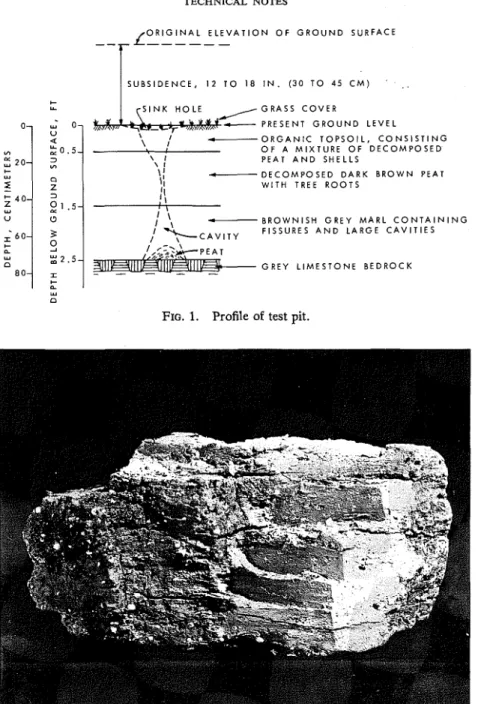
the area, several city blocks in extent, showed that streets, sidewalks, and driveways had re- quired frequent repair, that lawns had settled and that garages and fences were greatly dis- torted. The main dwelling units, probably 15 o r 20 years old, were founded on shallow bedrock and were undamaged although the ground around them appeared to have subsided some 12 to 18 in. (30 to 45 cm). Lawns and gardens had marked depressions, with soft centers, and most of these had c~vities below the sod cover. The 'springy' character of the ground surface suggested that the subsoil was highly organic. Two inspection pits were excavated in the center of the problem area. The profile (Fig. 1 )
TECHNICAL NOTES O R I G I N A L E L E V A T I O N O F G R O U N D S U R F A C E
--I-
f---
- O R G A N I C T O P S O I L , C O N S I S T I N G O F A M I X T U R E O F D E C O M P O S E D \ I PEAT A N D SHELLS c--- D E C O M P O S E D D A R K B R O W N PEAT W I T H TREE R O O T S U\
- B R O W N I S H G R E Y M A R L C O N T A I N I N G/
$ C A V I T Y F I S S U R E S A N D L A R G E C A V I T I E S "J ',;<;.$+-PEAT n G R E Y L I M E S T O N E B E D R O C K 80 I ' I w nFIG. 1. Profile of test pit.
FIG. 2. Marl located between bedrock at 2.5 ft (.76 m) and the peat at 1.5 ft (.46 m).
revealed 6 in. (15 cm) of turf and a mixture of decomposed peat and shells, probably the spoil from the house basements. This was underlain by 1 ft (30 cm) of highly decomposed peat containing little or no mineral soil, although some small tree roots were found in it. The organic layer rested on about 1 ft (-30 cm) of brownish gray marl consisting almost entirely
of small shells (Fig. 2 ) . Competent gray lime- stone bedrock was exposed at the bottom of the test pit below the marl.
The marl layer was heavily fissured with vertical wedge-shaped channels up to 5 in.
( 12.5 cm) wide; some contained organic matter that had fallen in from above. The channels extended vertically through the peat to the sur-
CANADIAN GEOTECHNICAL JOURNAL. VOL. 8, 1971
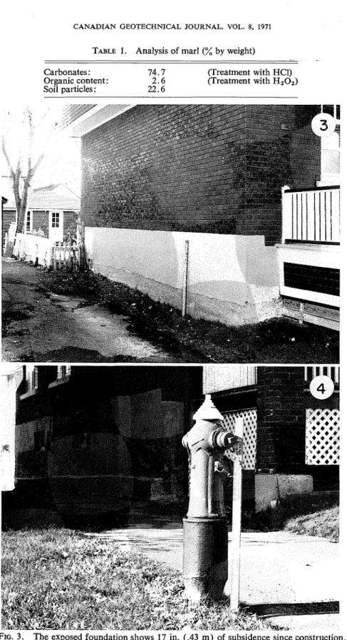
TABLE 1. Analysis of marl (A by weight)
Carbonates : 74.7 flreatment with HCI) Organic content: 2 . 6 (Treatment with H202) Soil particles : 22.6
FIG. 3. The exposed foundation shows 17 in. (.43 rn) of subsidence since construction. FIG. 4. A subsidence of 2 ft (0.6 m ) around fire hydrant.
TECHNICAL NOTES
FIG. 5. Earth mound around tree.
FIG. 6. Subsidence under sidewalk.
face where the 'sink-holes' appeared. Analysis converted into a residential area the ground- of the marl (Table 1 ) confirmed a suspected water table was at or near the surface. In this high carbonate content. saturated condition the peat and marl were It is believed that before the marshland was relatively stable. When the area was developed
596 CANADIAN GEOTECHNTCAL JOURNAL. VOL. 8. 1971
and sewer and water services were installed, the groundwater level probably receded, permitting the peat to decompose more rapidly. Rain, snow melt, and frequent watering by the resi- dents must have provided moisture movement through the organic layer, and the organic acids formed by the decomposing peats are thought to have reacted with the carbonates in the marl layer. Both the soluble portion of the organic material and the dissolved salts were gradually removed with the drainage water, slowly at first, then more rapidly, when the fissures in the marl enlarged into channels.
Deterioration of the marl and peat has re- sulted in a general subsidence in the area, but the houses are undamaged because they were
founded on the underlying bedrock. Structures such as garages and sheds which rest on the organic or marl layers, however, are seriously affected. Figs. 3 to 6 illustrate the effects of subsidence.
This note describes one of the rare cases where severe subsidence of the soil has de- veloped but houses are unaffected because they are founded on bedrock. It illustrates the need at the planning stage, for proper assessment of the future behavior of foundation soils with respect
tb
proposed structures and services.This note is a contribution from the Division of Building Research, National Research Coun- cil of Canada, and is published with the ap- proval of the Director of the Division.