Publisher’s version / Version de l'éditeur:
Vous avez des questions? Nous pouvons vous aider. Pour communiquer directement avec un auteur, consultez la première page de la revue dans laquelle son article a été publié afin de trouver ses coordonnées. Si vous n’arrivez pas à les repérer, communiquez avec nous à [email protected].
Questions? Contact the NRC Publications Archive team at
[email protected]. If you wish to email the authors directly, please see the first page of the publication for their contact information.
https://publications-cnrc.canada.ca/fra/droits
L’accès à ce site Web et l’utilisation de son contenu sont assujettis aux conditions présentées dans le site LISEZ CES CONDITIONS ATTENTIVEMENT AVANT D’UTILISER CE SITE WEB.
Technical Paper (National Research Council of Canada. Division of Building
Research), 1967-12
READ THESE TERMS AND CONDITIONS CAREFULLY BEFORE USING THIS WEBSITE. https://nrc-publications.canada.ca/eng/copyright
NRC Publications Archive Record / Notice des Archives des publications du CNRC : https://nrc-publications.canada.ca/eng/view/object/?id=a94c361d-24fe-4044-b52b-5a53c5a2dc6a https://publications-cnrc.canada.ca/fra/voir/objet/?id=a94c361d-24fe-4044-b52b-5a53c5a2dc6a
Archives des publications du CNRC
For the publisher’s version, please access the DOI link below./ Pour consulter la version de l’éditeur, utilisez le lien DOI ci-dessous.
https://doi.org/10.4224/20375759
Access and use of this website and the material on it are subject to the Terms and Conditions set forth at
Permafrost investigations in British Columbia and Yukon Territory
Brown, R. J. E.
Ser THl N21t2 n o . 2 5 3 e " 2 BLDG
NATIONAL RESEARCH COUNCIL OT' CANADA DIVISION OF BUILDING RESEARCH
PERMAFROST
BzuTISH COLUMBIA
INVESTIGATIONS IN AND YUKON TERRITORY
by
Af'r rtiLYZED R . J . E . B r o w n
Technical Paper No. 253 of the
Division of Building Research
OTTAWA Decernbet 1967
METHODS AND SCOPE OF. INVESTIGATIONS GLIMATE GEOLOGY TERRAIN Relief Drainage Vegetation S o i l s PERMAFROST High Areas L o w A r e a s
Air Photo Patterns Sloping Areas
Perrnafrost at High El.evation
W'idespread Section of Discontinuous Perrnafrost Zone DISCUSSION
Southern Fringe of Discontinuous Perrnafrost Zone 'W'idespread
Discontinuoue Perrnafrost Elevation and Slope
CONCLUSION P a g e L Z 1 3 1 3 I 6
r 8
Z T Z L 2 5z 6
2 7
2 7
3 0 3 3 3 4 3 5PERMAFR OST INVESTIGATIONS IN
BRITISH COLUMBIA AND YUKON TERRITORY
by
R . J . E . B r o w n
Since 1950 the Division of Building Research, National Research corrncil, has been studying lfie nurnerous construction
problerns caused by perrnafrost in northern Canada. A basic require-rnent in solving these problerns is knowledge of the distribution of perrnafrost and of the location of its southern lirnit; in-forrnation is being obtained continually frorn field investigations, scientific and technical literature, and reports frorn individuals and agencies working in perrnafrost areas.
Inforrnation regarding distribution and character of perrna-frost is particularly vital in the southern fringe where construction is cornplicated by patchy distribution of perennially frozen ground and the proxirnity of the ternperature to 32"F. The existence of perrnafrost
in this area is greatly influenced by the cornplex interrelationships arnong rnicroclirnate and local terrain conditions, which produce variable and unpredictable ground therrnal conditions.
At present the southern fringe of the perrnafrost region is experiencing increasing econornic developrnent with the establishrnent of new towns, cornrnunication lines, rnines and oil exploration. In the northern s€ctions of the western provinces of Canada and in a-djacent portions of the Yukon Territory and Mackenzie Distric! new roads are being constructed"*.
Because of t].e increasing developrnent and the unusua[y difficult engineering problerns encountered in the southern fringe of perrnafrost the Division of Building Research initiated in 19 62 a Long-terrn Prograrn of field surveys along the roads in the affected regions of the Province of Alberta and the Mackenzie District (1). In 1963, these field surveys were extended to the provinces of Manitoba and Saskatchewan (Zl. In 1964, a field survey was carried out in northern British Colurnbia and southern Yukon Territory. This will be followed in future years by sirnilar studies in the northern sections of the Provinces of Ontario, Quebec and Newfoundland into which tJle southern fringe of perrnafrost penetrates.
B e c a u s e t h e i n f o r r n a t i o n p r e s e n t e d i n t h i s r e p o r t w a s o b t a i n e d i n L 9 6 4 , t h e d e s c r i p t i o n o f t h e h i g h w a y n e t w o r k p e r t a i n s t o t h a t y e a r . S i n c e 1 9 6 4 , t h e h i g h w a y s y s t e r n i n t h e Y u k o n T e r r i t o r y h a s b e e n c o n s i d e r a b l y
The area of British Colurnbia north of 56'N and of Yukon Territory south of.65"N was chosen as the site of the 1964 investi-gations, which cornpleted the survey of western Canada begun in the Prairie Provinces two years earlier (Figure I). Studying the perrna-frost boundary in this physiographic region is difficult for several r e a s o n s :
(l) The only access by land nortle of the latitude of Dawson Cree\ B. C. (Mile 0, Alaska Highway - 56"N) is the Alaska Highway, which extends northwest into Yukon Territory (Figure 1). West of the Alaska Highway, in British Colurnbia, there is a recently constructed road extending southward frorn Watson Lake, Y. T. towards Stewart, B, C. (Stewart-Cassiar Highway). There is, however, a gap of approxirnately one hundred rniles in the southern portion of this road which has not yet been constructed. In the northwest corner of British
Colurnbia there is a branch road 50 rniles long extending south to Atlin, B. C. and to the Haines Highway which extends frorn the Alaska Highway to Haines, Alaska. Between the Alaska Highway and the aforernentioned roads, there is a large tract of virtually uninhabited country without land cornrnunications. The southwest and west central portions of Yukon Territory are served by the Alaska Highway and several branch roads. The eastern and nortl:ern portions of the Territory, like north-central British Colurnbia, are without land cornrnrrnications. The southern lirnit of perrnafrost on tire Alaska Highway occurs about 90 rniles nor{fi of Dawson Creek (56'N). Thus, tJle study area lies alrnost entirely within the perrnafrost region.
(Zl The study area is located alrnost entirely in the Western Cordillera, which is rnountainous and contains plateaus, interrnontane valleys and trenches. This rugged and variable relief (elevations range frorn sea level to rnore than I0, 000 ft) restricts extensive field work away frorn the roads. The distribution of perrnafrost is cornplicated by the extrerne variations in elevation producing a vertical zonation frorn discontinuous at lower elevations to continuous at higher levels. In many areas perma-frost occurs on rnountain slopes and sumrnits but not at the valley bottorns. Variations in horizontal extent and thickness of perrnafrost occur between adjacent north- and south-facing slopes in addition to the norrnal increase in these pararneters northward towards the continuous zone.
3
-Econornic developrnent of the area has been increasing consider-ably during the past few years along the Alaska Highway and branch roads. There is virtually no developrnent in the extensive areas not served by land cornrnrrnications. Mining developrnents have provided the rnain irnpetus to road construction. The Stewart-Cassiar Highway in northwestern British Colurnbia is being cornpleted to open that area to rnining developrnent. A new base rnetal rnine near Whitehorse began production in 196?. The road to Ross River in southeast yukon Territory was opened a few yearcs ago to provide access to the recently opened tungsten mine at tr'Iat River (in the District of Mackenzie). A new sixty-rnile long developrnent road has been cornpleted to an asbestos ore body north of Dawson y. T. The Dernpster Highway extends at present about eighty rniles northeast of Dawson to the Peel Plateau. Eventually it will link Fort McPherson, N. W" T. to the Alaska Highway. This road is the site of considerable oil exploration. Since the Second World 14ra{r the tourist possibilities of the Alaska Highway and branch roads have been expanded with the developrnent of many rnotels and carnpsites.
Contacts were established in Yukon Territory with the Northwest Highways Systern, Departrnent of Public Works, and the Yukon Territorial Governrnent Departrnent of Indian Affairs and Northern Developrnent, Whitehorse, Y. T. Considerable inforrnation was obtained frorn these agencies on perrnafrost conditions encountered during construction and rnaintenance of the roads. This included that portion of the Alaska Highway in British Colurnbia south to the end of pavernent at Mile 83 north of Dawson Creek, B. C. InJorrnation on perrnafrost was supplied also by the British Colrrrnbia Departrnent of Highways.
These field investigations were carried out in Septernber L964 when tJre depth of thaw had reached its rnaxirnurn, and seasonal frost of the forthcorning winter had not begun to forrn. Investigations were carried
out along the Alaska Highway frorn Dawson Cree\ B. C. (Mile 0) to the Yukon Territory - Alaska boundary (Mile I?301. Branch roads extending south of the A1aska Highway were investigated, including the Stewart-Cassiar Highway, Atlin Highway, Carcross Highway, and Haines Highway. North of the Alaska Highway, branch roads investigated included the Whitehorse-Mayo Highway, Dawson Highway and Dernpster Highway ( F i g u r e s I a n d 2 ) .
METHODS AND SCOPE OF INVESTIGATIONS
and terrain was obtained frorn the technical literature and agencies located in the study area. Aerial photographs and large-scale
topographic rnaps of selected areas were exarnined in the office to identify the various types of terrain and the character of the relief, vegetation and surface drainage. Frorn this prelirninary exarninatiorq potential perrnafrost locations were noted for subsequent field
investigations.
In the field, detailed investigations were carried out to obtain inJorrnation on the areal extent of bodies of perrnafrost, the depth to the perrnafrost table, and, where possible, the thickness oJ the perrnafrost. Supplernentary inforrnation included the type of vegetation, the thickness of the living surface vegetation cover, the thickness of peat tJre type of underlying rrineral soil and the character of the ground ice.
The rnain objective was to delineate the areas of perrnafrost and relate their distribution to the various environrnental features such as relief, drainage, vegetation and soil type. With this inJorneation it is possible to predict in a qualitative rnanner where perrnafrost might be expected in other areas.
Field equiprnent consisted of portable, rnanually operated equiprnent. A 6-tt, alurniniurn Hoffer probe and I I /Z-tncin diarneter
screw-type soil auger, both with 3-ft extensions, were used to deterrnine the depfh to perrnafrost and soil profiles in areas where perrnafrost did not exist. In frozen ground consisting either of peat or fine-grained rnineral soils, it was usuatrly possible to chop holes and obtain sarnples to a depth of 15 to 20 ft using the Hoffer probe equipped with a co6€-hardened serrated steel bit. Holes were also advanced to depths of 15 to 20 f.t by chopping with an ice chisel attached to 314-tn pipe and
cleaning out the frozen chips of soil with a Z-irrr. diarneter postJrole auger. Frozen clay soils eould usually be penetrated with t"he screw-type auger because of their plastic nature and considerable r:nfrozen water content at even several degrees below 32"F. Frozen silty and sandy soils could be penetrated for a few feet without difficulty, but frozetl stony and gravelly soils resisted the rnanual equiprnent.
The observations are listed in Table I beginning with the Alaska Highway and followed by the various branch roads rnentioned
5
-Previously. The location of each observation point is designated in Table r by the nurnber of rniles frorn the beginning of the road. P r e v a l e n t t y p e s o f t e r r a i n o n t h e southern section between Dawson creek and whitehorse are illustrated in tr'igures 3 to 14 inclusive.
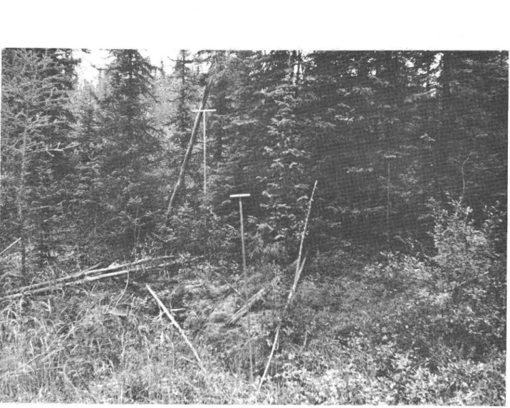
The following exarnple illustrates the use of tlee syrnbols in Table I to describe the terrain and perrnafrost conditions (Figure 6). Location No. 36 (Colurnl I) is located 254.5 rniles north of the southern terrninus of the Alaska Highway in British Colurnbia. It is a low area located in a peat bog (Colurnn 3 - L) in which ttrere are depressions and peat plateau:(. The background and right side in Figure 6 is a peat
plateau supporting dense spruce up to 30 ft high and tamarack (Colurnn 4 s(30) T). The depression on the left side is treeless (colurnn 4 - No). The gror:nd vegetation on the peat plateau (colurnn 5 - (p) ) consists of non-Sphagnun rnosses, Sphagnurn, lichen and Labrador tea (Colurnn 5 , MSph Ln Lt). The depression is covered with sedge and ground birch, and the water table is at the ground surface (colurnn 5 - se B (*) ). rn the peat plateau, the peat is 7 f.t 5 in. thick (column 6: T f.t 6 in. ); its thickness was not measured in the depression. The rnineral soil is clay (colurnn 8 - Yes) but not in the depression (Golumn g - No). The depth to the permafrost table in the peat plateau is 3 tt, g in. (Colurnn 9: 3 tt9 in.) and the perrnafrost is 14 ft 3 in. thick (Colurnn 10: 14 ft 9 in.) CLIMATE
The study area, cornprising northern British Colurnbia and soufhern Yukon Territory between 55"N and 65"N, is situated in a rnountainous region on the west side of North Arnerica. The following account is taken rnainly frorn The Clirnate of British Colurnbia and the Yukon Territory (3) and ttte Cfirn"ie
"f Carraaa 1+).
Despite the proxirnity of the Pacific Ocean, tJre Coast Mountains in the Alaska panhandle and the St. Elias Mor.mtains in the soutJrwest portion of Yukon Territory are so continuous and lofty that they forrn an effective barrier against Pacific rnaritirne influences. Several deep river valleys cut tfirough these rnountain barriers but tJrey are too
narrow and tortuous to allow rnuch penetration by air rnasses or disturb-ances frorn the Pacific ocean. On the east, the Rocky Mor:ntains in northern British Colurnbia and the Mackenzie Mountains in western
Mackenzie District provide less defence against winter cold waves frorn the
lies a cornplex of rnountain ranges and plateaux.
The clirnate is essentialry continentar, with rong cord
winters and shor! generally rnild to cool, surnmers. An outbreak of polar air rnay occur at any tirne during the sumrner and produce freezing ternperatures. Yukon Territorn and to a lesser extent norttrern British colurnbia, are subject to wide variations in ternperature during the winter depending on urhetleer t,Le dorninant influence is rnodified air frorn the Pacific or intensely cold air frorn the north or east. Although oceanic inJluences are rnodified by t"he rnountain barrier, winters are rnilder in soutfiwest Yukon Territory and northwestern British Colurnbia than in the interior' Within this broad frarnewor\ local variations in clirnate frorn one station to anotJrer are deterrnined by elevation and e:,<posure to pre-vailing winds. The clirnate also becornes increasingly severe toward.s tJre nortJl.
Air ternperature records are available for l5 stations in northern British colurnbia and 13 stations in yukon Territory (5 - g). Their locations are shown in Figure I and rnonthly and annuai averages of daily mean temperatures are given in Table II. Mean annual isotherrns are also shown on Figure 15 (9, lO).
In the soutJr, rnean annual air ternperatures vary frorn about 40"tr' at New llazelton, Alice Arrn and Stewattneat the coast to about 35'tr' in the interior at Dawson Creek and Fort St. John. Farther north irl British Colurnbia, the rnean annual air ternperature varies near the coast frorn 30"F depending on elevation to 35"F around Fort Nelson. In Yukon Territory, rnean annual air ternperatures vary frorri Zg"E to 30"tr in the south to about 25"tr'at the northern bor:ndary of the study area around Dawson and Mayo. Ilere, as in tJre soutl5 local variations depend on elevation and expobure" The coldest station is Snag in western yukon Territory with a rnearf annual air ternperature of ZZ"E.
January mean ternperatures are only srightly above zero in northwestern British Colurnbia. Srrmrner ternperatures are arnong tJre lowest recorded in the province with July *.u.r temperatrrres of 54"F at Atlin and 55"F at Dease Lake and Babine Lake. In the Peaee River vallen January ternperatrrres average about 5"F with mean July ternperatures of
60"tr'. Northward in the 3'ori Nelson River valley winter ternperatures are 10 degrees colder, while in July rnean ternperatures are quite sirnilar in both valleys.
7
-In Yukon Territory, which lies entirely north of latitude
60'N, winter days even in tlre south are short with no effective
sun-shine. In srrrnrner, long hours of daylight prornote rapid growth where
soil is availableo January rnean ternperatures are -loF at Whitehorse
and -3"F at Teslin in the southwest. The colder winters in the interior
are typified by January rnean ternperatures of -I2"F at Watson Lake and
-18"F at Dawson. The relief contributes to extrernely low rninirnrrrn
ternperatures during arctic cold waves. Snag holds the record for North
Arnerica of -81"F on February 3, L947. OtJrer rninirnurn records are
- 6 2 " 8 a t W'hitehorse, -63'F at Testint -73"F at Mayo and -74"F at
Watson Lake, Fortunateln periods of intense cold,are usually of short
duration. The transition period frorn winter to surnrner and vice versa
is very short, the rapid change in daily ternperatures reflecting the
changing altitude of the su-n. At Dawson, th. rnean ternperature rises
frorn 28"tr' to 57 "tr between mid April and rnid June. Surnrners are short
but warrn with all stations reporting rrrean ternperatures above 50oF
during June, July and August. Graphs of rnean rnonthly air temperatures
at three stations representing the southern, central and northern portions
of the study area are shown in Figure 16.
Freezing and thawing indices provide an indication of the
arnount of heat witfrdrawn frorn and added to the ground. On Figure 15
it can be seen that freezing indices vary frorn about 4000 degree days in tJle south to about 6500 in the vicinity of Dawson and snag (11, l2I. The range of thawing indices is srnaller varying frorn about 3500 degree
days in the south to 3000 in the vicinity of Dawson and Mayo.
Precipitation observations are available for the 28 stations
( 1 3 , 1 4 ) a n d a r e p r e s e n t e d in Tables III - V. Orographic effects are
noticeable in the distribution of precipitation in this rugged country.
East of the Coast Range in northwestern British Colurnbia, precipitation
is light, averaging l1 in. at Atlin and t5 in. at Dease Lake, and increasing
slightly eastward. ' Throughout the northeastern section of the province,
east of the continental divide, the annual precipitation varies from l5 to
l8 in., rnost of which occurs in the sruruner. Mean annual precipitation
is fairly uniJorrn over rnost of Yukon Territory, ranging frorn 9 to l? in.
at the valley stations for which records are available. There ig no
Pronounced wet or dry season, although at rnost stations July and August
The heaviest snowfall occurs at stations on the windward
slopes of the coastal rnountains in northern British Colurnbia where rnore t"han 200 in. are recorded annually at Alice Arrnand stewart. East of these rnountains annual snowfalls range between 40 and 80 in. British Colurnbia stations experience greater snowfalls, ranging frorn 50 to 80 in., than Yukon Territory, where annual totals range rnostlyfrorn 40 to 60 in. Heavier falls up to 80 in. occur in the Liard Valley (Watson Lake -83 in., Frances Lake - 72 in.l, in the st. Elias Mountains and on t6e westward slopes of the Mackenzie Mountains. July is the only snow-free rnonth at all stations except Beatton River, which experiences an average fall of 0. I in. Orographic effects are irnportant in the distribution of
snowfall as well as total precipitation. Data on the average deptJr of snow on the ground each rnonth are available for 4 stations in northern British Colurnbia and 7 stations in Yukon Territory (Table VI). Monthly depths are generally higher in British colurnbia. rt rnust be noted
that the recording stations are sparse and all located in the valley bottorns. The rnountains receive rnore sno% especially on the west slopes. Graphs of rnean rnonthly precipitation totars at 3 stations representing the
southern, central and northern portions of the study area are shown in F i g u r e 1 6 .
rn s'rnrnary, the clirnate of the study area is essentially continental, with large differences between surnrner and winter air
ternperatures and rnost of the precipitation occurring during the surnrner. The rnain differences in air ternperature result frorn latitudinal variations but the generally rnorrntainous relief causes rocal variations. precipitation totals are also inJluenced by latitudinal variations but orographic effects are lrrore irnportant. Hythergraphs based on the averages of the rnean rnontJrly ternperatures and precipitations for the 3 stations in Figure l6 are shown in Figure 17.
GEOLOGY
The study area lies alrnost entirely within the Cordilleran Region except for the northeastern corner of British Colurnbia in the vicinity of Dawson Creek and Fort Nelson, which lies in the Interior Plains physiographic province. The Cord.illera consists of three large systerns differing broadly in their geological structure and topographical character (Figure I8). The following account is taken rnainly frorn B o s t o c k ( 5 ) .
9
-The Eastern systern consists of two parts, narnelp the Rocky Mountain and Mackenzie Mountain areas. In the
"o,ttil tJie Rocky Mountain area extends to Liard River where it is followed. north by the Mackenzie Morrntain area. The latter curves in a great arc frorn Liard River to t].e west side of flre peer Rlver, north of the study atea, near
6 6 " N .
The Rocky Mountain area incrudes the Rocky Mo'ntain Foothirls, the Rocky Mo'ntains and. Rocky Mountain Trench.
The Rocky Mountain Footteills separate lihe rnountains frorn the Interior
Plains. Alttrough rnainly cornposed of ror:nded hills, they contain ou4ying rnountain ridges nearly as high and rough as those of the rnain rnountain area to the west. They are entirery of sedimentary origin, composed mostly of Mesozoic strata, but include Palaeozoic and Tertiary form-ations in rnany parts and sorne Precarnbrian rocks in the soutJr. The Rocky Morrntains forrn a continuous wall of mountains traversed by only one strearn - Peace River. Many peaks rise above 9000 ft, For the greater par! they consist of ridges with a northwesterly alignrnent nearly parallel with that of the entire Rocky Mountain area. The ridges are separated by deep valleys cut along zones weakened by folds,
fractures, ahd relatively soft strata. They are rnainly forrned of
Palaeozoic sedirnents, but include sorne of late Precarnbrian age. The Rocky Mountain Trench is the great valley tying directly west of the Rocky Morrntains forrning their western boundary. The floor of the trench varies in width frorn 2 to rnore than l0 rniles and lies between 2000 and 3000 ft above sea level.
The Mackenzie Mountain area, of rnore varied character than the Rocky Mountain area, consists of rnountains, plateaux and plains. Only the Liard Plateau and the northwest corner of the Mackenzie Morrntains lie within the study areao The Liard plateau.is an area of broad, even-topped ranges of hills rising rnore than 4500 ft above sea level separated by wide valreys 1500 to z5oo ft above sea level. The plateau is underlain by the sarne Palaeozoic and Mesozoic sedirnentary
forrnations, as in the Rocky and Mackenzie Mountai-ns. The rnountains , in the northwest corner of the Mackenzie Mountains are rugged, with peaks rising above ?000 ft above sea level. The sedirnents are of palaeozoic and Mesozoic origin but are thinner t.|an in tJre Rocky Mountains and sorne areas of Precarnbrian strata rnay be exposed.
The Interior Systern forrns the great interrnediate rrnit of
the three systerns of the Canadian Cordillera and cornprises rnost of
tJre study area. It is cornposed of several rnajor and rninor rnountain
and plateau areas arranged in segrnent pairs. Each pair consists of
a rnountain area on the east and a less rnountainous plateau area on
the west. The area on the east is underlain largely by old rocks
including thick sections of Precarnbrian sedirnents and later intrusive
rocks. The area on the west is forrned to a greater extent except
in the north, of younger rocks and less intrusive rnaterial.
In the southern part of the study area the Central Plateau
and Mountain Area is cornposed of Ornineca and Cassiar Mountains on
the east and Skeena Mountains and Stikine Plateau on the west. The
highest peaks in these rnountains exceed 8000 ft above sea level and the
Plateau levels are above 4000 ft. In tfre north, the Northern Plateau
and Mou::tain area is rnore diJficult to divide because of its cornplex
topography and geology. In its southern part it is cornposed of Selwyn
Mountains on the northeast Ogilvie Mountains on tJ:e northwest and
Yukon Plateau on the southwest. The rugged Selwyn Mountains contain
som.e peaks that exceed 9000 ft elevation and the Ogilvie Mor:ntains
sorne that rise to elevations of 7000 ft. The Yukon Plateau has a varied
topography consisting of several platear:x, rnountain ranges and large
persistent valleys. The platear:x are about 4000 to 5000 ft above sea
level. The highest morrntains rise above 6000 ft. The trench-like
Tintina Valley and Shakwak Valley are about 5 to l0 rniles wide, and their floor elevations are between 1500 and 2500 f.t. Liard Plain is a large basin at an elevation of about 2500 ft. Hyland Plateau is forrned of broad valleys and rolling hills rising to an elevation of 4000 ft.
The W-estern Systern of the Cordillera in Canada includes all
land areas southwest of the Interior Systern. It is corrrprised of three
parts: the Coast Mountain area, the Outer Mountain area, and the Coastal
Trough" The Coast Mountain area, which borders the Interior Systern
in the study area in British Colurnbia forrns a continuous barrier of
extrernely rugged rnountains, sorne rising to elevations exceeding I0, 000
tt. They are forrned largely of granitic intrusive rocks of the Coast
Range batholith. The St. Elias Mountains of the Outer Mountain area
in northwestern British Colurnbia and southwestern Yukon Territory are
the highest rnountains of Canada, the highest being Mt. Logan rising to
19, 850 ft above sea level. The Coastal Trough is a depression lying
1 1
-Glaciation was widespread in the Cordillera during the
Pleistocene,and glaciers persist today in rnany places, chiefly in the
St. Elias and Coast Mountains (Figure 19). A large area in the
north-west corner of the study area in Yukon Territory escaped glaciation
because the high St" Elias Mor::rtains barred the rnoisture-laden winds
from the Pacific to such an extent that ice did not forrn in rnuch of the
interior, despite the increased coldness of tJ:e period"
During the Pleistocene tJ:e Rocky Mountains appear to have
been an area of relatively light precipitation and the effects of
glaci-ation are light. Most of the Liard Plateau appears to have been covered
by ice and the lower parts were well scoured. In the northwestern
end of the Mackenzie Mountains cirque and valley glaciers were active.
In t.Le Interior Systern, glaciation in the Ornineca and Cassiar Mountains
was variable. Sorne ridges and valleys were heavily scoured while
others were relatively lightly glaciated. Wide areas of Skeena Morrntains
were covered with ice and their lower levels and rnain valleys were
rnuch scoured. At present srnall ice fields and glaciers are scattered
through nearly all the ranges. Most of Stikine Plateau was covered
by Pleistocene ice to about 6500 ft, only a few isolated morrntains in
the plateau areas being high enough to project above it. The Liard
Plain and Hyland Plateau were rnantled by thick deposits of glacial
drift. In the Selwyn Mountains, ice extended in rnost areas to elevations
of 3000 to 5000 ft. There were rnany nunataks, and glacial deposits and
scour are widespread. A few srnall glaciers and icefields are present
today in these rnountains. It is believed that tlae effects of Pleistocene
glaciation dwindled northward and westward in the Ogilvie Mountains
although to the northeast sorne valley glaciers pushed to near the borders
of t]'. e rnorrntains. The eastern half of Yukon Plateau was covered with
Pleistocene ice but the west half cornprising the Klondike Plateau shows
no signs of glaciation.
Glaciation was very active in the Western Systern. Ice
pro-bably covered all but the highest parts of the Coast Morrntains. Active
glaciation on a dirninished but still considerable scale has continued in
these ranges with periods of oscillation up to the present extensive
stage of alpine glaciation. During the Pleistocene the ice fields of
St. Elias Mor:ntains were higher and pushed their glaciers out on all
sides. On the interior side they extended far out on Kluane Plateau.
The upper lirnit of ice during the later Pleistocene was probably about
The portion of the study area in northeastern British Colurnbia lying outside the Cordillera is underlain by Mesozoic rocks rnainly of Upper Cretaceous age. The rocks are rnainly sedirnentary consisting prirnarily of shales and sandstones. Sirnilar rocks of lower Cretaceous age forrn a band on the west side of the area bordering the Rocky
Mountain Foothills. Glaciation covered the area with drift. The relief' tlrroughout rnost of the atea is that of a plain dissected by wide incised river valleys bordered by broad terraces which give way to rolling uplands with low hills. In the south the relief is rolling with sorne plateau areas among low to high ror:nded hills.
TERRAIN
Relief
The relief of the area under shrdy is varied, consisting of rnountain ranges, interrnontane valleys and trenches, and plateaux (Figure 20). In nortJrern British Colurnbia, the region west of the continental divide is one of varied relief including several distinct rnountain ranges and associated valleys. The extrerne nortbeastern portion of the province lying east of the Rocky Mountains has rnainly level to rolling relief. A drainage divide rising to 4000 ft separates the Peace River basin in the south frorn the Fort Nelson and Liaid
River basins in the north. Yukon Territory is a rugged land of rnountain ranges and plateaux; Be'tween tJre Rocky Mountains and the Coast
Mountaias lies the Interior Plateau, a rough irregularly rolling upland witJl an ayerage elevation of 4000 ft but with large areas exceeding 5000 ft and isolated rnountains reaching 6000 ft. Cutting through rnountains and platear:x are nurnerous river valleys, sorrre with flat bottorns and sloping sid.es and others deep narrow gorges with pre-cipitous sides.
Elevations on the Alaska Highway and branch roads in the study area are variable. Between Dawson Cree\ B. c. and whitehorse the Alaska Highway varies frorn about 1000 ft above sea level to 4200 f.t at Surnrnit Lake about 100 rniles west of Fort Nelson. 'W'est of $rhitehorse the Alaska Highway does not rise above 4000 ft. Elevations of the branch roads are also all below 4000 ft.
Local relief consists of alternating elevated areas and depressions {hereafter referred to as tthigh areasrr and rrlow areastt respectively);
_ 1 3 _
differences in elevation vary frorn only a fewfeet to about ZO f,tand rnore. These high and low areas vary in extent frorn a few hundred yards to several rniles. Occasional low areas of a few hr:ndred yards occur within high areas and vice versa.
The ground surface of the elevated areas is srnooth and virtually devoid of the rnicrorelief features that are comrrron in the depressions; trrese consist of hurnrnocks and peat plateau:( rising to 3 or 4 ft above dre surrounding surface.
Drainage
Regional drainage is provided by rivers frowing between
rnountain ranges in valleys and trenches. The study area is approxirnately cut in haU by the continental divide. East of the divide in British Colurnbia and southeastern Yukon Territory, the peace, Liard, and r-ort Nelson Rivers flow eastward into the Mackenzie River system. W'est of ttre con-tinental divide rnost of British Colurnbia and southwestern yukon is drained through the Alaska panhandle to the Pacific Ocean by tJre Skeena, Nass, Stikine, Taku and Alsek Rivers and their tributaries. Norttrwestern British Golurnbia in the vicinity of Teslin and Atlin Lakes an6 western Yukon Territory are drained by t.Le Yukon River.and its tributaries west-ward into Alaska.
Local drainage varies considerably frorn good to excessive on mountain slopes and high areas to poor in valley bottorns and depressions. Bog conditions occur in low-lying areas; slightly elevated areas such as peat plateau:K are well drained. The greatest area of bogs occurs soutJr of Fort Nerson, B. c., where trrey extend for about 40 rniles.
Vegqtation
Most of the study area lies within the taiga or boreal forest region, which extends east-west across Canada in a band several hundred rniles wide. The generally mountainous terrain causes subalpine forests at high elevations and tr:ndra above the treeline. These ,r.g.Ltion regions are described by J.s. Rowe (r6) and their distribution is shown in
F i g u r e 2 l .
The Boreal Forest Region in
south-east corner of the shrdy area there is an outlier of the Aspen Grove section occurring in peace River vailey between Dawson creek and Fort st. John. Aspen (p"p.tr" t"e*u"ta.d is the only species abr:ndant in natural stands. e-i""rrt p"pt"" 1p"porn" u"rr i" frequently present on rnoist lowlands,
"nd o@"o
prorninent on uplands after fires. ilrhite birch (Betu1a papvrifera) is scattered but is usually found onry on rough,
btot.rlirEl-Surrounding this aspen outlier in the southeast corner of the area under study is the Mixed 'Wood Section. The characteristic forest association on well-drained uprands is a rnixture of aspen, balsarn poplar, white birch, white spruce (Ftc.a_glg"cr) ana balsarn fi" (Abi." btl""*""). The cover type of gGlest areal extent is the aspen. Jack pir. (Piro" Fa"ksi"ra) grows on sandy areas and drier till soils, and rnixes witle bfack spruce (Picea otariana) on the plateau-like tops of higher hills. Black spruce
" 1
grow on poorly drained and boggy areas.
North of the Mixed Section lies the Lower Foothills Section. The Lodgepole Pit. (Pi*"
"ottoJt" r"". .Iffi), along witJr aspen and balsarn poplar, has beCorrt" a"rnittaoi.rtut fiG, white spruce and. black sPruce are frequently present with scattered white birch on weII-drained sites and tarnarack on poorly-weII-drained sites.
The Northern Foothills Section lies west of the previous section and the dorninant species are white spruce, black spruce and lodgepole pine. Broadleaved trees are not abundanf altJrough sorrre birch is scattered through uprand stands, aspen appears on south-facing slopes, and balsarn polar is present on lowland alluviurn. In general, the forest stands are patchy and open.
The northeast corner of British Colurnbia is in the Hay River section, which represents the northern extension of the Mixed wood Section sornewhat rnodified by a colder drier clirnate. The quality of the forest growth is not as good, and black spruce predorninates on ttre plateau-like uplands as well as in its usual lowland habitats. The rnixed white spruce-poplar stands are fewer in number.
An arrn of the Upper Mackenzie Section extend.s up tr'ort Nelson River to Fort Nelson, B. C. and. westward along Liard River. '\4rhite spruce and balsarn poplar forrn the rnain cover trypes on alluvial flats bordering ttre
rivers. On the benches above the soils are occttpied by pine, aspen, black spruce and tarnarack.
1 5
-floodplains, large areas of sandy and in rnoist to wet positions, by
On the east and west sides of the previous section lies the Upper Liard Section. Good forest growtJr is found here, particularly on soils of the alluvial flats. The dorninant tree species are white sPruce and balsarn poplar, usually in pure stands. Above the river floodplains, tJre spruce grows with rodlepole pine, aspen and white birch on the best sites, with alpine fir o'th.tigrru" lands. Black spruce and tarnarack occur in low positions and tlee forrner species is also prorninent on upland fine-textured soils #here it assoliates with white spruce and lodgepole pine.
In northwestern British Colurnbia, the Stikine Plateau Section is cornprised of an open rnixture of aspen, white spruce and lodgepole pjre, interspersed with grassy areas. White brich is scattered and black cottonwo"a (p"potrr" t"i.h"."rd appears on river banks. Sorne alpine fir grows near the tieEine.
Four sections of the Boreal tr'orest Region are fould in that portion of the study area rocated in yukon Territory. rn the Eastern Yukon section, rnixed stands of white spruce, aspen and birch grow on south and west facing slopes but north and east facing slopes are
frequently non-forested. Alpine fi" (Abi." l""io."rp") grows on the higher slopes either associated with
"pr".. ""d birc\ or alone forrning a scrub growth at tirnber line (usually below 5000 ft elevation). On lower slopes and valley terraces the forest cover is dorninated by white spruce, lodgepole pine and aspen in the soutrrern parts, and by whiie spruce and birch northward. and in the rnountains. Black spruce grow in bogs and on slopes underlain by perrnafrost accorrlpanied by tarnarack on the forrner sites and by birch on the latter. Floodplains are generally narrow and support local patches of balsarn poplar and white spruce on alluviurn.
The Central Yr:kon Section occupies the south central part of the-territory. The best forests grow in protected lowlands with growth grading off as elevation increases. 'l4rhite
spruce grows up to 3000 ft- At these elevations it associates with a$ine fir, which
ascends to 4000 or 5000 ft. Grasslands are i:rterspersed with islands of white sPruce' willow and aspen on the rnountain slopes. Erosional barrens
occur in areas of soil instability. Lodgepole pine and white spruce
dorninate in the valleys on water-rnodified tills and coarse terrace
rnaterials. Spruce, pine and aspen in association are also cornrnon.
Pine is particularly prevalent on dry sandy soils in the southeasfi to
the west and north it dirninishes. Tarnarack is rnostly lirnited to the
eastern side. Black spruce grows on level organic soils where the water
table is high.
The southwest corner of Yukon Territory is occupied by
the Kluane Section cornprising a narrow strip in the rainshadow of the
St. Elias Mor:ntains. In the cold dry clirnate of t.Le Yukon Platear:,
the vegetation has a park-Iike appearance. The best forests are
cornprised of white spruce and poplar in the river valleys. $rhite
spruce, aspen and birch grow on the benchlands. Open forests of
white spruce giving way to grassy treeless areas at about 4500 tt elevation grow on the upland slopes.
The Dawson Section cornprises the northwest portion of
the study area. Valley slopes are the rnain forest habitaf supporting
stands of white spruce, either pure or rnixed with birch or aspen.
The aspen favours dry hilltops and steep south facing slopes. The
rnost favourable spruce site is on lower slopes. In valley bottorns,
bogs and e:cposed uplands, strmted stands of white and black spruce are
usual except on levees adjacent to the rivers where white spruce
pre-dorninates. Sorne alpine fir associated with white spruce grows up
to the treeline at about 2500 ft.
The souttrern portion of tJ:e shrdy atea in the Cordillera lies
not in the boreal forest but in the Subalpine Forest Region. This region
is represented by the Interior Subalpine Section, which extends frorn
southern British Colurnbia. This forest is greatly fragrnented occupying
tJre rnor:ntainous uplands up to the treeline surrounding the Nechako
Plateau. Engelrnann spruce (piceg
"rggltrg"li) is widespread in
association witJr alpine fir which increases in abr::rdance at higher
elevations and dorninates at treeline. Lodgepole pine grows extensively
in burned over areasc The lower boundary of this forest lies generally
between 3000 and 3500 ft. Below these elevations, spruce-pine forests
are continuous frorn rnountain slope to rnountain slope across the
1 7
-Throufihout the area under shrdy, variations occur in trre vegetation due tg changes in local relief. The trlow areasn are charactetized by bog vegetation - open bogs wit]: scattered shrnted black spruce growing on deep accurnurations of sphagnurn and sedge bogs. The best btact spf,uce growth occurs where the organic accumu-lation is relativqly thin and drainage is irnproved; this is a characteristic of both sedge an{. sphagnurn bogs. The tallest brack spruce grow to about 30 ft. Tar$arack is cornrnor5 either rnixed with black spruce, or less frequently, [n pure stands. scattered jack pine growing to z0 ft, are encountered [.n drier bogs. The gror:nd cover consists predorninantly of sphagnurn, *i+h patches of feather and crub mosses, lichen and
Labrador tea. Xllhere are also extensive wet sehge rneadows.
The tt?ligh areasrt with rnoderate to good drainage support a rnixed cover of white spruce, black spruce, alpine fir, lodgepole pine, aspen and balsarr[ poplar rxrith undergrowth of willow and alder.
The tallest treeslS"o* to 80 and 100 ft in dense stands averaging about 5 ft between treep. Areas with rnore lever relief, poorer drainage and finer textured soils have white spruce as dre rnajor cover, with occasional aspen{ Irnproved drainage, coarser grained soils and rnore irregular relief t,esults in an increase in aspen and a d.ecrease in white sprucer ultirnately giving rise to relatively pure aspen stands wit.L occasional white lbirch on the crests of high areas in soils of sand-clay-loarn texhtres. \rlixed aspen'jack pine forest growth is cornrnon in regions of well-sorted safids. The ground vegetation consists of various berry plants, grasses, ilabrador tea, discontinuous cover of feather and club rnosses, and sorne lichen.
scatter'ed burned over areas occur in the shrd.y area.
tr'ollowing a fire ft appears tJrat aspen is tJre rnain species to regenerate on rnediurn to fing-grained soils, and jack pine the rni.in post-fire
species on sandy hreas. Soils
Throughout the shrdy area the soils vary frorn coarse-grained sands to gravel tg fine-grained sirts and clays. Their character is strongly influencdd by their nature of origin, the coarss-grained soils being associated With till and rnoraine deposits, t]:e fine-grained. soils with alluvial and ]acustrine deposits. tr'ollowing deposition of these
rnaterials, profile developrnent has occurred producing pedological variations.
Rowe (f 6) has described tJre pedological characteristics of the soils in each of his forest sections. In the Aspen Grove Section surface rnaterialg are deep tilIs and glacio-lacustrine deposits, rnainly of loarn to clay loarn texture and rnoderately calcareous. Black earth profiles are predtorninant although sorne podzolic degradation can be recognized underi aspen stands. In the Mixed Section rolling rnorainic deposits occur on the uplands and srnootJeer glacio-lacustrine deposits on the lowlands. The characteristic soil developrnent is grey wooded,.
Brown wooded soils occur on level calcareous alluvial flats and terraces in tfie NortJrern Foothills section. Grey wooded soils have developed orn the upland tills. Regosols are corrunon on colluviaL rnaterials and pedts in poorly drained positions. To the west in t"Le Upper FootJrills flection, the glacial deposits and colluvial rnateriaf and tJre rnature seils show podzol or grey wooded developrnent. rn norttreastern British Colurnbia, glacial ad.vance over Devonian lirne-stones incorpora{ed a high proportion of calcareous rnaterial in t}re surface drift of the Hay River section. soil profiles are frequently high in lirne and $ence shallowly leached.
rn the upper Mackenzie section, bedrock is rnosdy buried deeply under till pr ffrore recently deposited lacustrine and alluvial rnaterials. Grey wobded and brown wooded soils are developed on well-drained sites in the soutlrern parts, altJrough irnrnattrre profiles are more usual in alhflviurn. NortJrward, tlre presence of perrnafrost prevents soil pro{ile developrnent. There are large areas of swarnp and peat. The sof.l rnaterials in tlre Upper Liard Section are d.erived frorn glacial alltriviaf and colluvial deposits developed on wide river valleys, broad tetraces, and rolling uplands with low hills. rn tJre Stikine Platear4 ap. uneven cover of till lies on tJre uplands, and alluvial and colluvial deposits occur in the valleys"
Heavy glaciation occurred in the Eastern yukon, central Yukon, and Kluanf Sections resulting in till being the rnain rnaterial. rn tJ.e Eastern Yu$on sectior5 the till is rnainly calcareous. soil profile developrneht in t.Lis rnaterial and in the valley alluvial deposits is lirnited. Peaty soils are extensively developed due to the widespread
_ 1 9 _
interruption of internal drainage by perrnafrost. In the Central Yukon Section, soil developrnent is generally weak because of the youtJrfulness of the surface rnaterials and the dry clirrrate. Brown wooded soils are usual but grey wooded and degraded dark brown profiles also occur. Rooting depth of plants is affected in sorne areas by layers of volcanic ash and northward by perrnafrost. Soil profile developrnent in the tills of the Itluane Section is lirnited.
surface deposits in the unglaciated Dawson section are
rnainly residual, due to breakdown in situ of tJre underlying Precarnbrian and Tertiary rock. There h"" be.tG-ffii.ficant accurnulation of volcanic ash in sorne places and this apparently has sorne adverse effect on rooting of trees. Generally, the effects of parent rnaterial variations are ov€r-shadowed by tJre prevailing youthfurness of profile developrnent. sorne shallow, reddish-brown forest soils have been noted.
In tJ:e Interior Subalpine Section of the Subalpine Forest Regior5 the residual and glacial surface rnaterials are variable in texture and cornposition. Soil developrnent has also been variable in response to the wide range of local clirnatic conditions occurring in this rnountainous region. Lithosols and shallow podzols are rnost frequenfi brown wooded and brown podzolic profiles are less colnrnon.
PERMAT'ROST
The area under shrdy cornprising northern British Colurnbia, north of 56"\ and southern Yukon Territorn south of 65"N, is located in ttre discontinuous perrrrafrost zo:ne. In tJre Cordillera, however, tJre distribution of perrnafrost varies witJr elevation as well as latitude. The southern lirnit of perrnafrost shown on the rnap (r'igure zzl rnarks
approxirnately the boundary of perrnafrost occurrence at valley bottorn levels. In the west, this boundary is located in tJ:e southwest corner of Yukon Territory, tr'rorn here it tends in a southeasterly direction corresponding to tJre pattern of rnean annual air isotherrns to about 58.N in northeastern British Colurnbia.
In the southern fringe of the discontinuous zor,e lying north of this line, perrnafrost occurs in scattered patches varying in extent frorn less than l0O ft wide to several acres. The thickness of these patches varies frorn I to 2 ft at tJ:e southernrnost exf,rernity of tJ:e
pernaa-frost region to about 100 ft (approxirnate thickness at Aishihik, Y. T. estirnated to be 50-I00 ft). The northern portion of the area under study lies in the zone of widespread discontinuous perrnafrost. Perrna-frost varies in thickness frorn lnore than I00 ft (approxirnate thickness at Dawson, Y. T. estirnated to be 200 ft) in the south to rnore than 500 ft at the north end of the Dernpster Highway.
South of the boundary of perrnafrost occurrence at valley bottorn levels, perrnafrost exists only at higher elevation. Throughout northern British Colurnbia, field observations indicate that the lower lirnit of perrnafrost is uniforrnly at about 4000 ft above sea level. Below this elevation, scattered perrnafrost islands occur only in specific types of terrain. Between 4000 ft and 6000 ft it appears that perrnafrost occurs in scattered patches, equivalent to the southern fringe of the discontinuous zone; between 6000 ft and 8000 ft perrnafrost is probably discontinuous but widespread; above 8000 ft it is probably continuous.
The rnor:ntainous relief causes local variations within the above described pattern. Perrnafrost is rnore widespread and thicker on nortb facing slopes than south facing slopes. In sorne valleys, perrnafrost occurs on north facing slopes but is absent on south facing slopes. The active layer is thinner on north facing slopes. Terrain factors such as vegetation and snow cover vary with slope and exposure; cornplicating further the distribution of perrnafr ost.
The Alaska Highway and branch roads within the area r:nder study are located alrnost entirely below an elevation of 4000 ft above sea level. The highest point is at Surnrnit Lake, about Mile 390, where the ALaska Highway rises to an elevation of 4350 ft. Alrnost all field observations on this survey were rnade on the highways and thus reflect the perrnafrost conditions existing below the 4000 ft elevation. A few observations were rnade at rnines at higher elevations.
Three stretches of highway extend south of the southern lirnit of perrnafrost shown in l.igvre 2?z the AIaska Highway frorn Dawson Creek (Mile 0) north for about I50 rniles, the Stewart-Cassiar Highway south of Cassiar for about 150 rniles, and the Haines Highway. Along the Alaska Highway a few scattered patches of perrnafrost were encountered in peat bogs. The rnost southerly perrnafrost on the Alaska Highway was encountered at Mile 94.4 north of Dawson Creek (Location No. 5, Table I, Figure 3) where the perrnafrost is about 5 ft thick. Northward the next occurrence of perrnafrost, also in a peat bog, was fotmd at Mile 153.0
z r
-nortlx of Dawson Creek (Location No. I l, Table I) just about at the southern lirnit on the rnap. Perrnafrost was found at only one location on the Stewart-Cassiar Highway 154 rniles south of the Alaska Highway (Location No. Lzz, Table r). No perrnafrost was encountered on the Haines Highway (Figure 23).
In the soulCrern fringe of the discontinuous zor:.e, perrnafrost in flat gror:nd was restricted rnostly to peat bogs. None was found in the relatively elevated stretches (high areas), which support tree growth consisting prirnarily of dense poplar and jack pine wittr tatl spruce and sorne birch.
In the peat bogs occupying the depressions (Iow areas), the vegetation consists prirnarily of two associations:
1. Little or no tree growth; rnarsh sedge L to Z ft high and thin nloss, predorninantly of the feather and other non-Sphagnurr types; scattered patches of Sphagnurn. These areas are aknost always very wet.
?. Scattered, stunted black spruce and tarnarack; thick, often very hurnrnocky Sphagnurn, scattered occasional patches of lichen; Labrador tea. sorne of these areas are wet and sorne are fairly d"y.
In tJle rnorrntainous areas, rnost of the peat bogs are only a few hundred yards in extent, being conJined by slopes. Peat bogs in river valleys and plateau areas arce rnore extensive, covering several acres or square rniles. south of Fort Nelson, the Alaska Highway traverses extensive peat bogs frorn about Mjre 245 to Mile 285 (Location Nos. 35-46, Table I).
Perrnafrost is found frequently on north facing slopes sup-porting spruce and extensive rnoss cover but not on opposite south facing slopes where tlee tree growth is rnainly deciduous and rr:ross
cover is patchy. For a distance of about I50 rniles, the Alaska High-way is located on the north side of Liard River valley frorn Mile 483 in northern British Colurnbia to west of Watson Lake. No perrnafrost was reported along this section located on a south facing slope except at Leguil River, Mile 557-558, where it switches back onto a north
facing slope. The vegetation on other north facing slopes along this section of the Alaska Highway is sirnilar to Leguil River area and
perrnafrost probably exists on these slopes. W'est of Whitehorse on
the A1aska Highway, and on the whitehorse-Mayo Highway north of
'whitehorse,
perrnafrost on north facing slopes is rnore widespread
and thicker. Possibly it occurs on sorne south facing slopes where
local vegetation or snow cover conditions favour its developrnent. H i g h A r e a s
The terrain conditions encountered in high areas along the highways in the southern fringe of the discontinuous zorte are sirnilar to those of high areas near the southern lirnit of the perrnafrost
region in the Prairie Provinces (I, Zl. Elevations above the low areas ranged between a rnaxirnurn of about ZO ft, with a considerable slope to the adjacent low areas, and less than I f! with an alrnost
irnperceptible slope.
The tree species include jack pine, spruce, balsarn, poplar and scattered birch varying in height frorn 40 to 80 ft. The stands
are usually dense, trees averaging 2 to 5 ft apart. Undergrowth of
willow and alder grows to a rnaxirnurn height of about 10 ft. rn rare
cases, one or two tarnarack were observed. Generally, the ground
cover consists of forest litter with patehes of feather rnoss, Sphagnurn and lichen. Soils range frorn gravel to clay with stones and organic rnatter. The soils are frequently wet, the water table rising to within a few feet of tJre ground surface.
Nrrrnerous high areas, including those rnentioned here, served as gravel and borrow pits during construction of the roads in the study
area. No perrnafrost was encountered in subsurface investigations or
in pits used for highway construction. The high area at Mile 500 on the Alaska Highway is typical (Figure IZ).
L o w A r e a s
Along the Alaska Highway in the southern fringe of the
dis-continuous zone between Dawson Creek (Mile 0) and Whitehorse (Mile 918), 84 low areas covering the range of terrain conditions were investigated for perrnafrost. They vary in extent frorn a few hundred feet to several
2 3
-occur in thern.
Generally, the tree growth consists of stunted, scattered
spruce varying in height frorn 2 to 20 f.t, with occasional tarnarack,
willow, alder and ground birch. The ground surface vegetation is a
rnosaic of sphagnurn, feather and other rnosses, Labrador tea and
tnarsh sedge in various cornbinations. The rnicro-relief varies frorn
flat to very hurnrnocky. rndividual hurnrnocks vary to a rnaxirnum
height of 3 ft and diarneter of 4 ft. Variations in elevation frorn one
association to another range through several feet. peat plateaux rising 2 to 3 ft above the surrounding, poorly drained areas are
prevalent. Surface and subsurface drainage is variable. Standing
water is usually associated with rnarsh sedge areas and rnany of tJre
lowest lying sphagnrrrn areas. The peat plateaux and individual
hurnrnocks are drier. Depth to the rnineral soil (through the rnoss/lichen
and peat) in 84 sites varied within wide lirnits frorn 2 in. to rnore than
7 tt, with an over-all average of 2 ft 4 in. This is considerably less
than the average of 3 ft 9 in. encountered in saskatchewan and
Manitoba (2). The thickness of the peat exceeded 5 Lt at only 8 sites.
As in the high areas, the rnineral soil includes coarse and
fine-grained rnaterials. Silts and clays predorninate and sand was not
encountered south of Mile 274.8 (Location No. 42, Table r). stony
soils were found frequently, occurring at 30 of the Il0 locations
south of $rhitehorse. Only 4 of the stony soil sites occurred south
o f M i I e 2 7 4 . 8 .
Perrnafrost was encountered in 46 of. t"he 84 low sites exarnined.
Sphagnum is a cornponent of the ground cover at 37 of the perrnafrost
sites and was absentfrorn the ottrer 9 perrnafrost sites. At the 3g sites
with no perrnafrost, Sphagnurn forrns part of tJre ground. cover at only
14 sites. Lichens (Cladonia sp. and Cetraria sp.) grow at 66 of the 84
low sites and were absent at the other 18 sites. rn the 66 low sites
where lichen was growing, perrnafrost was encountered in 4t sites
and not in the rernaining2S. In the 18 low sites where no lichen was
growing, 5 had perrnafrost and l3 did not. These observations are
Sphagnurn No Sphagnurn Lichen
No Lichen
* A low hill or knoll soil about I0 ft or p e a t b o g s . Perrnafrost 3 7 9 4 T 5 No Perrnafrost L 4
2 4
z 5
1 3The depth of the perrnafrost table was deterrnined at 5I locations. It occurred above tJ:e rnineral soil in the peat in 40 of these locations.
The average depth to perrnafrost of 51 deterrninations was I ft ll in., and the rninirnurn depth to the perrnafrost table encountered throughout the investigations was I ft 3 in. The rnaxirnurn deptJrs encor.rntered were 3 f.t 6 in. and 3 ft 9 in. The depth of the perrnafrost table at rnost of the sites was encountered between the I ft 6 in. depth and 2 ft 6 in. depth.
Perrnafrost thickness was deterrnined at 22 sites. The thinnest perrnafrost encountered was 3 in. atMile 882, about 50 rniles southeast of Whitehorse (Location No. 108, Table I). The thickest perrnafrost t h a t w a s p e n e t r a t e d o c c u r r e d i n a p a l s a * a t M i l e 2 5 4 . 5 a b o u t 5 5 r n i l e s south of Fort Nelson (Location No. 36, Table I, Figure 6). The perrnafrost is probably thicker than L4 f.t at sorne other sites whe4e subsurface observations were rnade. The position of the perrnafrost layer relative to the vertical position of the peat was exarnined at the 5I perrnafrost sites. At 6 of thern, perrnafrost was confined to the peat layer; at another 5 the bottorn of the perrnafrost layer coincided with the peat-rnineral soil interface. Perrnafrost extended frorn peat into the rnineral soil at 27 sites, and at l l sites the perrnafrost layer occurred below the peat entirely in the rnineral soil.
Ice was encountered in many of the holes advanced into perrna-frost. Much of it occurred in layers, the thickest about Ll4 in. trt was forrnd also in the forrn of srnall pellets and other randorn inclusions.
The relationship of perrnafrost occurrence to tree species was also noted. Jack pine was encountered in 12 of. the low sites. Perrnafrost
of perennially Itozen peat and rnineral less in height occurring in peatlands or
2 5
-occurred fur 2 of these but not ln the rernainlng 10. Tamarack wae encountered ln 20 ol the low eites with perrnafroet in 9 and not in the rernaining ll.
Microrelief in the forrn of hurnrnocks, peat plateaux, ridgee
and rnounds rising to heights of I to 4 ft above tJre eurrounding ground eurface, was encorrntered at 63 of the low eitee. perrnafrost was encountered at 39 of these gites. The horizontal dirnensions of tfte palea at Mile 254.5 were not determined but it covered an area at leaet 100 ft equare. The flat top of tJre palea wae about 4 f,t above the surrounding bog surface, and was covered with a few tarnarack, and dense spruce up to 30 ft high and z to 5 ft apat't. The gror:nd cover consisted of Sphagnurn and other rnosses, lichens and Labrador tea growing on humrnocks I ft high. The peat was z ft 6 in. thick overlying blue-grey rnottled cLay. Depth to perrnafrost was 3 ft g ir., and it was 14 ft thick. rce occurred in rl{-ir-. layers and nodules.
The eurrounding peat bog was wet, supporting
" "p""Je growth of sPruce, tarnarack and gror:nd birch with ground cover of sedge. Perrnafrost was h.bsent here.
Perrnafrost conditiona on the Alaska Highway soutJr of
White-horee are typified by ttre following observations
Location No. 28 (Alaska Highway - Mile ZOB.5) (Figure 5)
Soil Frofile: 0 to 3 ft 4 in. - peat
below 3 ft 4 in. - silty clay
L ft 4 in. to below 3 f.t 4 in. - perrnafrost Location No. 48 (Alaska Highway - MiIe 295) (Figure 8)
Soil Profile: 0 to 4 ft 8 in. - peat
4 f,t I in. to Z ft 9 in. - eilty fine
to rnediurn sand with stonee to llZ-in. dlarneter.
2 f.t O in. to below ? tt 9 in. _ permafrost
Location No. 93 (Alaeka Highway - Mile Zgg.5) (I.igure 14)
Soil Profile: 0 to about l0 ft - peat
, below l0 ft - clayey silt