Cyclone Shelters and Cyclone Resilient Design in Coastal Areas of Bangladesh By Zheng Jia Bachelor of Architecture Tsinghua University
ACH IVES
MA SSCHSTTS-,- INST I tU T E r" ~toYLC Beijing, China (2010)UBRA
ESc
Submitted to the Department of Urban Studies and Planning in partial fulfillment of the requirements for the degree of
Master in City Planning at the
MASSACHUSETTS INSTITUTE OF TECHNOLOGY
September 2012
@ 2012 Zheng Jia. All Rights Reserved
The author here by grants to MIT the permission to reproduce and to distribute publicly paper and electronic copies of the thesis document in whole or in part in any medium now known or hereafter created.
Author
/1
Department of Urban Studies and PlanningAugust 21, 2012
Certified by
(9!
Accepted byProfessor James L. Wescoat, Jr. Aga Khan Professor of Architecture
Thesis Supervisor
Professor Alan Berger Chair, MCP Committee Department of Urban Studies and Planning
Table of Contents Abbreviation 6 Glossary 8 Acknowledgement 9 Abstract I1 Chapter 1. INTRODUCTION 13
1.1 Hazard, Risk and Vulnerability 13
1.1.1 The Tropical Cyclones of Bangladesh
1.1.2 The Risk and Vulnerability in Coastal Regions of Bangladesh
1.2 Problem Statement 18
1.2.1 The Cyclone Shelters in Bangladesh
1.2.2 Major Problems of the Existing Cyclone Shelters
1.3 Conceptual Framework and Methodology 24
1.3.1 Conceptual Framework 1.3.2 Methodology
1.4 Study Area 26
1.5 Towards a New Approach 28
Chapter 2. A BROAD REVIEW: 31
HISTORICAL EVOLUTION, CONTEMPORARY CYCLONE MITIGATION,
AND FUTURE CHALLENGES IN THE STUDY AREA
2.1 Historical and Environmental Evolution in the Study Area 31
2.1.1 Natural Dynamics
2.1.2 Ethnic Diversity
2.1.3 Interactions between Humans and Nature in History
2.1.4 Summary of the Environmental History
2.2 Overview of Post-Colonial Cyclone Mitigating Measures 38
2.2.1 Embankments and Polders 2.2.2 Cyclone Shelter Programs
2.2.3 Early Warning, Awareness Raising and Communication
2.2.4 Coastal Zone Management
2.2.5 Post-Sidr Cyclone Management
2.3 Future Challenges of Cyclone Mitigation in the Changing Climate 50
Chapter 3. ZOOM IN: 53
ANALYSIS OF THE CYCLONE SHELTER NETWORK AT DIFFERENT SCALES
3.1 Scale 1: The Coastal Region of Bangladesh 55
3.1.1 Demographic Context in the Coastal Region
3.1.2 Risk Areas and Geographical Zones in the Coastal Region of Bangladesh 3.1.3 The Distribution and the Current Condition of Cyclone Shelters in the Coastal
Region
3.2 Scale 2: Districts and Sub-districts -Patuakhali District and KalaparaUpazila 60 3.2.1 Nature Settings and Socio-economics of Patuakhali District
3.2.2 Risk and Vulnerability to Cyclones in Patuakhali District 3.2.3 Cyclone Shelters in Patuakhali District
3.2.4 Vulnerability to Cyclones and Conditions of Cyclone Shelters in Other Coastal Districts
3.2.5 KalaparaUpazila
3.3 Scale 3: Unions and Towns - DhulasharandLataChapli Unions and KuakataPourashava 70
3.3.1 Introduction to the Analysis of Cyclone Shelter Network at the Union Scale 3.3.2 Dhulashar Union
3.3.3 LataChapli Union
3.3.4 KuakataPourashava
3.3.5 Comparative Analysis at the Union and Town Scale
3.4 Scale 4: Cyclone Shelter Sites 82
3.4.1 Introduction to Site and Architecture Analysis of Cyclone Shelter Sites 3.4.2 Gangamati Primary School Cyclone Shelter (Dhulashar Union)
3.4.3 DhulasharAnantopara Primary School compound (Dhulashar Union) 3.4.4 Dhulashar Union Parishad compound (Dhulashar Union)
3.4.5 AzharUddin mini Cyclone Shelter (Dhulashar Union) 3.4.6 LataChapli School compound (LataChapli Union) 3.4.7 Community Center (LataChapli Union)
3.4.8 LataChapliGovt. Primary School compound (KuakataPourashava) 3.4.9 HEED Cyclone Shelter (KuakataPourashava)
3.4.10 Summary of Analysis of Cyclone Shelter Sites
3.5 Scale 5: Typical Settlements and Dwellings in the Study Area 118
3.5.2 Bengali Rural Settlement Patterns and House Form in Barisal and Patuakhali 3.5.3 Rakhine Villages and Houses
3.5.4 Landless Poor Settlements along Embankments, and Fishermen Huts along Seashore
3.5.5 Urbanized Areas in Barisal and Patuakhali Districts
3.5.6 Precedents of Alternatives: Action Aid Shelter for Landless Project
(Dhulashar Union)
3.5.7 Precedents of Alternatives: Red Crescent shelters for the poor(LataChapli
Union)
3.5.8 Summary on Typical Settlement Patterns and Alternative Projects
Chapter 4. ZOOM OUT: 129
CYCLONE RESILIENT DESIGN PROPOSALS IN DIFFERENT SCALES
4.1.1 Cyclone-resistant Individual Shelters
4.1.2 Improvements in New Designs of Cyclone Shelters
4.1.3 Afforestation and Alternatives on Livelihoods as the Adaptation to Climate Change
4.2 Methodology in Design Proposals 136
4.3 Design Components 137
4.3.1 Design Principles
4.3.2 Design Component Options
4.4 Design Proposals for Individual Dwellings and Villages 163
4.4.1 Spatial layouts of villages
4.4.2 Cyclone-resilient houses and mini cyclone shelters 4.4.3 Flexible houses
4.4.4 Summary of design proposals for individual dwellings and villages
4.5 Design Proposals for Cyclone Shelter Sites 172
4.5.1 Design proposals for cyclone shelter sites
4.5.2 Summary of improvements of existing cyclone shelter sites
4.6 Planning Proposals at the Union Scale 181
4.6.1 Planning based on topography, forests and alternatives of livelihoods 4.6.2 Improvements on cyclone evacuation system
4.6.3 Summary of cyclone-resilient planning proposals at the union scale
4.7 Suggestions for Supporting Policies and Regulations for Cyclone Resilient Planning 188 and Design at the Coastal Zone Scale
Chapter 5. CONCLUSION 192
5.1 Overall Summary 192
5.2 Major Contributions 194
References and Websites 203
Abbreviation ADPC BBS BCDPC BDRCS BIDS BMD BRAC BUET BWDB CBDRR CCS CDMP CDS CEGIS CNG CPP CZPo DFID DMB DWF EC EPWAPDA FAO FAP FCDI GIS GOB GPS GRRP HQ ICZM LGED MCSP MoEF MoFDM NGO NWP PCO - ICZMP PEDP PIP PMO
Asian Disaster Preparedness Center Bangladesh Bureau of Statistics
Building Community Disaster Preparedness Capacity Project Bangladesh Red Crescent Society
Bangladesh Institute of Development Studies Bangladesh Meteorological Department Bangladesh Rural Advancement Committee'
Bangladesh University of Engineering and Technology Bangladesh Water Development Board
Community Based Disaster Risk Reduction Committee on Cyclone Shelter
Comprehensive Disaster Management Programme Coastal Development Strategy
Center for Environmental and Geographic Information Services Compressed Natural Gas
Cyclone Preparedness Program Coastal Zone Policy
Department for International Development Disaster Management Bureau
Development Workshop France European Commission
East Pakistan Water and Power Development Authority Food and Agriculture Organization
Flood Action Plan
Flood Control, Drainage and Irrigation Geographic Information System Government of Bangladesh Global Positioning System Gorai River Restoration Program Headquarter
Integrated Coastal Zone Management Local Government Engineering Department Multipurpose Cyclone Shelter Programme Ministry of Environment and Forests Ministry of Food and Disaster Management Non-Governmental Organization
National Water Plan
Program Development Office for Integrated Coastal Zone Management Plan Primary Education Development Programme
Priority Investment Program Prime Minister's Office
1
BRAC was founded in 1972 as Bangladesh Rehabilitation Assistance Committee, a small project in rural Bangladesh. In 1973 it becameBangladesh Rural Advancement Committee. Gradually, the scope of BRAC was expanded to urban areas in Bangladesh, as well as other countries in Asia and Africa. Accordingly, now the organization is simply named BRAC.
Public Works Department
Bangladesh Space Research and Remote Sensing Organization Technology for Agriculture
United Nations Development Programme
United Nations Economic and Social Committee for Asia and the Pacific Union Parishad
Water Resources Planning Organization
7 PWD SPARRSO TECA UNDP UNESCAP UP WAPRO
Glossary
Aila: the name of the strong cyclone in May, 2009 which resulted in extensive loss in Bangladesh and India
Bakarganj: also called Backergunje, Backergunge, or Bakerganj, a former district in British India. It is mostly in Bangladesh nowadays, covering current Barisal Division and other places.
Bengal: the geographical and historical region in Ganges Delta which mainly divided by Bangladesh and the Indian state of West Bengal today
Bengali: the ethnic group who are native to the Bengal region char: newly formed land through the process of accretion crore: 10,000,000 in South Asian numbering system denizen: occupants
khal: river
khas land: large lands in the coastal region of Bangladesh originally belonging to large estates, and then authorized by the government as a result of state acquisition
killa: earth mound or fort
kutcha: constructions made of indigenous materials mud, wood, bamboo, etc. that are usually not resistant to devastating disasters
lakh: 100,000 in South Asian numbering system madrasa: a Muslim school that teaches Islam
mouza: a land area similar to the concept of village, which used to be the smallest administrative unit that was more important than today
pargana: a former administrative unit in the India subcontinent, introduced by the Delhi Sultanate parishad: council, administrative unit in rural local government system in Bangladesh
pourashava: municipality in Bangladesh
pucca: good quality; usually referring to good-quality constructions with materials such as concrete, asphalt or brick.
Rakhine: an ethnic group who mainly live in the Rakhine State of Myanmar today. A group of Rakhine descendants also live in the Chittagong Hill Tracts and the Barisal Division in Bangladesh
Sidr: the name of the super cyclone taken place in November, 2007 which caused tremendous damage in Bangladesh
Sundarbans: the world's largest tidal mangrove forest (single block) in Bangladesh and India, which is also a UNESCO World Heritage Site
taluqdar: local land owner who also has social impacts.Taluqdars were originated from Mughal land governance system.
thana: sub-district upazila: sub-district
verandah: roofed open space, such as a porch, in architecture
wapda: nickname for coastal embankment in Bangladesh since those embankments were firstly built by the (East Pakistan) Water and Power Development Authority (WAPDA)
Acknowledgement
To my mum, dad, grandma, grandpas (on both mother and father sides), aunt, uncle, grandaunt, granduncle and cousin, I remain eternally grateful for your endless love to me. Thank you for strongly supporting me to enter the field of architecture and planning and to study abroad in the United States.
To Prof. James Wescoat, I would like to express my overwhelming gratitude for your amazing guidance throughout the past year. Thank you so much for leading me to the world of water-related disaster resilient design and landscape heritage conservation in South Asia. Thanks a lot for your strong support for every step of my study. Your philosophy, your attitude to life, your research interests and experiences, and your integrated and expanded way of thinking have greatly influenced me. I feel so happy, warm and fortunate to be your student.
To Architect Dr. Nizamuddin Ahmed and Prof. ZebunNasreen Ahmed from BUET, thank you so much for your great help and efforts in realizing my amazing adventure to Bangladesh. Your love to the people and vernacular architecture, and your passion in contributing to the real world have deeply moved and inspired me. Thank you for helping me to understand Bangladesh deeper through showing me impressive things and places. The twenty four days in Bangladesh are one of the most wonderful and unforgettable experiences in my life.
To Dr. ReinhardGoethert, my thesis reader, thank you so much for giving lots of important feedback to my thesis. Your expertise in shelters has greatly benefited my study. As a hero in the world of development, you have taught me a lot on how to be a practitioner in the real world and how to engage with people. The time with you is always full of incredible fun.
I gratefully acknowledge AmunulKawserDipu, the National Emergency Coordinator at
ActionAid Bangladesh, for offering lots of help for my research in Bangladesh. Thank you very much for arranging the trip to Patuakhali and setting up interviews with experts, as well as sharing your adventurous stories with me.
I am very grateful to KhondakerHasibulKabir at BRAC University, for giving me so much
inspiration and those poetic and peaceful moments in Bangladesh. Thank you for sharing your impressive projects and research. Your philosophy and way of life have opened doors for me.
I convey special thanks to my friend Tazrin Ahmed, who initially introduced Bangladesh to
me, as well as inspired and motivated me to the field of sustainable architecture and disaster resilient design. I really hope we can do something meaningful together in the future. I feel also very grateful to Architect Anna Heringer, the recent Loeb Fellow at Harvard University. Your projects, lectures, dialogues and the mud workshop really inspired, moved and motivated me.
I would like to thank the experts in Bangladesh with whom I had inspiring conversations that
have significantly benefited my research: Prof. Jamilur Reza Choudhury, the head of the consulting team in Multipurpose Cyclone Shelter Programme who sketched a comprehensive scenario of the problems and needs of cyclone shelters; EkramElahiChowdhury, the Director of Cyclone ProparednessProgramme who provided valuable information of the cyclone early warning system; ParthahefazShaikh, the head of Food Rights & Sustainable Livelihoods sector in ActionAid Bangladesh who introduced their shelter project for the landless poor in Dhulashar; and Mohammad AminurRahman, the lecturer at the Postgraduate Programs in Disaster Management of BRAC University who introduced the cyclone shelter network in Bangladesh.
During my field research, I was warmly accommodated and accompanied by the
KuakatataluqdarMuangKyous Min. I would like to thank you sincerely for offering great help and sharing enjoyable days in Kalapara. I also want to thank the engineer at ActionAid who assisted and accompanied me to Dhulashar for intensive site analysis and interviews. Meanwhile, I would like to thank the chief officer of Dhulashar as well as the teachers in the schools I visited in Patuakhali, who told me the true stories in their cyclone shelters. Moreover, I want to thank all the men, women and children who I talked or interacted with during my time in Bangladesh.
I am very grateful to Prof. Eran Ben-Joseph at MIT who has been consistently supportive of
my research interests, as well as Prof. Jan Wampler, Prof. Tunney Lee, Prof. BishSanyal, and Associate Prof. Annette Kim at MIT who supported my thesis research spiritually, emotionally and intellectually. I would like to thank Associate Prof. Jean Yong at Singapore University of Technology & Design for introducing me to the world of mangroves. I am also very grateful to Ms. Sandra Wellford who has helped me a lot as the academic administrator throughout the process, as well as to Ms. DeeptiNijhawan who assisted me with visa issues.
To ShammiQuddus, thank you for the great help of getting me connected to Bangladesh, as well as inviting me to the wonderful dinner at your home in Chittagong. To my friends Albert Ching and Stephen Kennedy, thank you for "saving my life" in Dhaka. To MahbubRahman, KamrunLipy, KuheliChowdhury, TasnimaShefa, Nu ShwePrue, U Chaw Prue, NaziaAfsoon, TanvirPorag, Arch. QaziAsiful Islam, Engr. Md. Shuboktagin, Mohammed ShaheenRaju, Kamal Mahmood, Sharif, Faminda, Masuk Ahmed Xitu and your family, MuntasirMamun, SwaponRahman, Tonmoy Hussein, Nahid, and Md.ShakhawatChowdhury, thank you for helping me and sharing wonderful time together in Bangladesh.
I would like to thank RingoTse for being consistently supportive and helpful in my life for the
past three years. Thanks a lot for sharing similar interests and visiting me in Bangladesh.
Last but not least, thank you my friends in China and US, for being supportive and sharing the happiness and bitterness of writing thesis: Keren Charles, AlpitaMasurka, Samira Thomas, Li Bin, ZhongXiaofan, Qu Lu, Zhan Yun, Chen Yang (MCP), Chen Yang (phD), Anya Rutkouskaya, Marisa Lau, TusharKansal, Elizabeth Hoffecker, KiraIntrator, Marlene De La 0, Paula Winicki, AngHadwin, XuJingsi, Travis Sheehan, Lindsay Reul, Stephanie Shin, Matt Weinstein, AdityaBarve, Andres Bernal, Celina Guzman, Ghizal Adina, Alice Shay, Matt Bunza, Yang Xuan, JiWanjing, Vasudha Gupta, Janet Shih and Jessica Huang.
Abstract
Bangladesh is one of those countries that are most vulnerable to tropical cyclones. In recent decades, cyclone mitigations by the Government of Bangladesh and international organizations have greatly increased the coastal communities' resistance to cyclones. This thesis focuses on cyclone shelter programs, one of the most important cyclone mitigating measures. Although cyclone shelters have proven to be effective, they are currently not adequate, which requires more research and development for a more resilient future.
This thesis has five chapters: an introduction that defines the problem, a broad review of settlement history and hazards in coastal Bangladesh, a planning chapter that zooms in on the issues at five spatial scales, followed by a design chapter that zooms out from proposals for improving shelter site planning to a more comprehensive analysis of the spatial network of shelters, and larger-scale coastal environmental planning and policy. The conclusion highlights the main contributions of this research: 1) developing a multi-scale integrative approach; 2) expanding the range of choice for structural cyclone mitigations; and 3) addressing environmental and cultural diversity and specificity in physical planning and design. This research can contribute to the improvement of cyclone shelters in Bangladesh and so as to make a successful program even more successful.
Keywords: Bangladesh, cyclone shelters, flood hazards, mitigation, disaster resilient design
Chapter 1.INTRODUCTION
Lying on the vast, low and hydro-morphologically dynamic delta of Ganges and exposed to the frequent cyclone landfalls from the Bay of Bengal, Bangladesh is under high risk fromwater-related disasters, such as catastrophic cyclones.Its poor economy and its population that is the densest in the worldmake Bangladesh extremely vulnerable to tropical cyclones.
As a pioneer in cyclone mitigation, Bangladesh has reached great achievements in the past two decades in reducing human casualties from devastating cyclones. However, there is still a long way to go as the current cyclone mitigations are not sufficient.Moreover, the coastal region of Bangladesh is facing severe challenges of climate change and rapid population growth.
This thesis research focuses on cyclone shelters, one of the renowned and dominant cyclone mitigations.From a planner's and designer's point of view, this thesis research will provide a broad review of the cyclone mitigations in Bangladesh, an in-depth analysis of the cyclone
shelter network at different scales, and a range of choices for cyclone mitigation design in a sustainable future.
Chapter 1 gives an introduction to the context and the research. Chapter 2 offers a broad review of natural settings, environmentalhistory, contemporary cyclone mitigations, and future challenges of the study area. Chapter 3 provides a zoom-in study through five scales of analysis
- the coastal region, the district and the sub-district, the union and the town, the cyclone shelter site, and the individual dwelling - in order to analyze current conditions, problems and potentials of cyclone shelter network at different scales. Chapter 4 then zooms out to build a wider range of choice for a multi-scale, integrated and flexible cyclone shelter network, and also elaborates several design and planning proposals.
1.1 Hazard, Risk and Vulnerability
countries.The country has apopulation of over 160 million on a land area of 147,570km2
(56,980mi2), with a population density of 964/km2 (2,497/mi2). It ranks the firstin the world
among countries with population over ten million. 'It has a GDP per capita (PPP)of US$1,414, ranking 149 out of 180 countries (IMF, 2011).Bangladeshhasaround 95% of its total population at risk in multiple water-related natural hazards (World Bank, 2005).
1.1.1 The Tropical Cyclones of Bangladesh
With 53% of the worldwide cyclones that caused over 5,000 casualties taking place in Bangladesh, it is rated as one of the world's most vulnerable countries to tropical cyclones (UNDP, 2004, p.4).
The Bay of Bengal is recorded as one of the world's most activezonesin developing tropical low-pressure systems (Paul, 2009).About 10% of the tropical cyclones in the world are originated in the Bay of Bengal, among which around one-sixth had landfall into the coast of Bangladesh(Islam, 2011). Although the number of cyclones originated in the Bay of Bengal is not extremely significant in the global total, they are often the most destructiveamong all the cyclones.About 80-90% of worldwidelosses due to cyclonesare blamed onthose formed in Bay of Bengal (Chowdhury, 2002).Since 1584 AD, 16 out of 35 worldwide cyclones with death tolls exceeding 5,000 took place in Bangladesh and another 11 in India (Ali, 1999, p. 111).
The tropical cyclone with storm surge is the most devastating natural hazard in Bangladesh.It leads to huge lossesin livelihoods and coastal infrastructure. The coast of Bangladeshis struck by severe cyclones nearly every three years (World Bank, 2010). The cyclones take place particularly in pre-monsoon months from Aprilto early June, and post-monsoon season of late September to November (BUET &BIDS, 1993, p.1).
Historically,cyclones have led to tremendous damageon the Bengal coast. A rough estimate
'Bangladesh is the most densely populated large country in the world. There are other sovereign states and dependent territories with denser population, but those states or territories are city state/ territory or small countries, such as Hong Kong, Singapore, Malta, etc.
indicates that four severe cyclones in 1584, 1737, 1876 and 1897 took a combined heavy casualty of at least 914,000 (GOB, 2009).
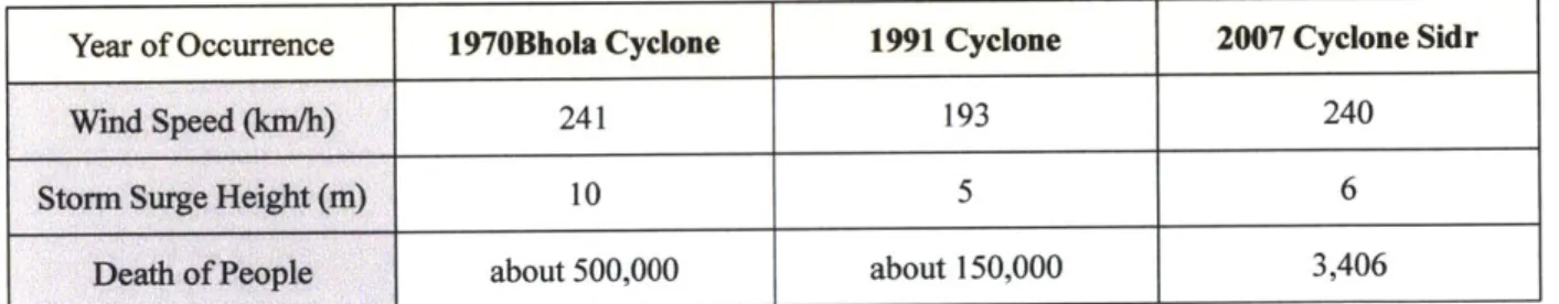
In recent decades, three super cyclones have led to huge losses in terms of lives and properties.The 1970 Bhola Cyclone hit the entire coast of Bay of Bengal with a storm surge of 10m high which led to a total death toll of about500,000 in the former East Pakistanbefore the establishment of the People's Republic of Bangladesh in 1971 (Khalil, 1992). It is the most fatal cyclone recorded and one of the deadliest natural disasters in modem history (Hossain et al., 2008).The 1991 Bangladesh Cyclone, which killed around 150,000people in Bangladesh, isalso one of the most terrible natural hazards. It serves as a continuous reminder about the destructiveness of cyclones for Bangladeshi people. The 2007Cyclone Sidr with a wind speed up to240km/hourresulted in 3,406 casualties, 1,001 missing and over 55,000 injuries. Itaffected livelihoods of 8.9 million people and losses totaled US$1.67 billion (GOB 2008).
The comparison of these three most devastating cyclones of recent decades in Bangladesh can be summarized in the table below:
Year of Occurrence 1970Bhola Cyclone 1991 Cyclone 2007 Cyclone Sidr
Wind Speed (km/h) 241 193 240
Storm Surge Height (m) 10 5 6
Death of People about 500,000 about 150,000 3,406
Table 1.1 Comparison of three most devastating cyclones of recent decades in Bangladesh (Source: Khalil, 1992. GOB, 2008)
1.1.2 The Risk and Vulnerability in Coastal Regions of Bangladesh
Besides the frequent attack from deadly tropical cyclones, Bangladesh's geography and topographyalso subject it to higher risk of destruction from tropical cyclones. Situated on the world's largest alluvial delta of Ganges-Bramaputra Rivers between Himalayas and Bay of Bengal, Bangladesh has a flat and low lying coast (most of which is only a few feet above the sea level) directly exposed to hazardous cyclones. In the coastal region,62% of its land has an elevation of
lower than 3 meters and 86% lower than 5 meters (CEGIS, 2009, p.ix).
Figure 1.1 The Topography of Bangladesh (Source: WARPO, NWMP vol.1, 2001)
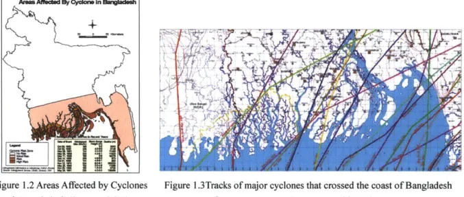
Bangladesh's geography and coastline put its coastal region under risk from cyclones. Its "funnel"-shaped of coast line makes the storm surge accumulate to higher levels (CCS, 1991, p.1). Moreover, it has a coastal line of 710 km exposed to Bay of Bengal, which is quite long
compared to the size of the country. Tropical cyclones have ever made landfalls on different places along almost the entire coast zone of Bangladesh.
Figure 1.2 Areas Affected by Cyclones Figure 1.3Tracks of major cyclones that crossed the coast of Bangladesh inBangladesh (Source: GOB) from 1960 to 2009 (Source: World Bank, 2010)
The loss of lives, properties and livelihoodsin tropical cyclones is mainly resulted from strong winds, heavy rainfall and storm surges associated with cyclones (IMD report).The strong
wind mixed with flying debris may heavily damage houses, especially inthe areas in the path of the cyclone eye due to the strong twisting power. Roofs with weak joints to the houses may easily get blown away. Heavy rains associated with cyclones may result in floods, damage of infrastructure, and soil erosion. Storm surges induced by the wind storms are often the major cause of devastation and the most destructive element in cyclones (Karim and Mimura, 2008,
p.492). Storm surges in Bay of Bengal can easily get to high level since they are inversely related
to the water depth of the sea which is shallow in that region. The great pressure and high speed of water along with floating debris have the strongest power of destruction. Moreover, if the strong storm surge occurs during the high tide period, it may induce the worst devastation.
Parts of Asia that fall within the coastal region of the Indian Ocean have the largest population in the world that is at risk form coastal flood. As a result, a relatively larger population in the Indian Ocean Coast is exposed to cyclones compared to the other coasts worldwide, which leads to a higher level of vulnerability.
1' -I
Figure 1.4 People in the Coastal Flood Risk Zone Worldwide (Source: CCC Report, 2011, p.55)
The population is distributed almost evenly in most parts of the country, including the coastal region. The coastal zone, defined by the Comprehensive Disaster Management Programme (CDMP) is composed of 16 districts. It has a population of 38.2 million under risk from cyclones.
The underdeveloped economy also makes the people more vulnerable to cyclones.
17
People in the coastal flood Risk Zone
30 25 20
15- -
---10)
CPO' cx 'Cp: 'Cpo' CPO, c'%'- C00' V"OV, C'00 cps, CPO, NIV ow ocp -"so ?A 0j'O '\* 01 00 0* $06 OY -'w% V o
' ?'
0,0P
NO tv-
two
ONO
S-
'Opvsoo N" '0'.Nvl
o Soo,
Agriculture, fishery and wage labor are the dominant sources of livelihoods in the coastal areas. People's livelihoods in the coastal zone, especially agriculture, are also under risk from cyclones. Whenever the cyclone occurs, people lose their livelihoods, properties, and even lives.
Moreover, most people in the coastal zone live in poorly built settlements.Mostpeople in Bangladesh live inkutcha houses made of mud, wood, bamboo, corrugated iron (CI) sheet, etc., while onlya small percentlive in pucca or semi-puccahouses made of bricks and concrete (Lewis and Chisholm, 1996, p. 29). The poorly built houses can be easily damaged or even taken away
by strong wind, low pressure, floating debris, heavy rains and storm surges in cyclones.
In sum, the coastal zone of Bangladesh is under high risk from tropical cyclones. The large population and high population density in coastal areas, underdeveloped economy and livelihoods, as well as poorly built houses have mademost of the coastal communities extremely vulnerable to cyclones.
1.2 Problem Statement
1.2.1 The Cyclone Shelters in Bangladesh
Although extremely vulnerable to frequent floods and cyclones, Bangladesh is renownedfor itssuccessfulmitigationmanagement of water-relatedcalamities. With increased awareness of the risk from cyclones in the coastal regions of Bangladesh, various measures have been implemented
by both former East Pakistan Government and the Government of Bangladesh to evacuate people
to specific locations and to protect their livelihood.There are intangible and tangible mitigation measures. This research focuses on the tangible measures in the cyclone preparedness stage.
Both natural and man-mademeasures protect people from the cyclones.In the natural aspect, mangrove forests and coastal landforms in Sundarbans and other coastal regions serve as natural barriersprotecting the low and flat land againstdisastrouswind and storm surge. The man-made protections, mainly the cyclone shelters andthe embankments and polders, play important roles in saving people's lives and developing coastal infrastructures.Beside afforestation, cyclone
shelters and embankment-polder system, the well-organized social programs such as early warning, awareness raising and communication also play crucial roles in reducing the loss from cyclones.This thesis gives a broad consideration toall of the above, but uses cyclone shelter network as the core of the research.
Among all of its cyclone preparedness strategies, Bangladesh's cyclone shelters network is currently one of the key approaches, which has also received worldwide attention in the field of disaster management. Cyclone shelters are basically concrete buildings lifted above the ground on stilts or killas (earth mound). The early cyclone shelters were built only for evacuation purpose while most of the later shelters are multi-purpose structures that can be used as offices, schools or health centers on a daily basis.
Figure 1.5 Some of the typical cyclone shelters in Bangladesh (Source: CEGIS, 2009)
After the deadly cyclone of 1991, the Multipurpose Cyclone Shelters Programme (MCSP) in the storm surge prone areas of Bangladesh was commissioned on the basis of a recommendation of the Inter-ministerial Task Force on Cyclone Shelters, set up by the Planning Commission of Bangladesh. Methodology, planning and design of new shelters were comprehensively studiedby the Government of Bangladesh, UNDP, the World Bank and BUET.In the last2O years, there has not been any comprehensive cyclone shelters program that is comparable to the MCSP in 1993.
The 1993 MCSP was successful, together with GOB'sachievements in storm forecasting and
early warning, in terms of reducing casualtiesfrom severe tropical cyclones in Bangladesh. According to official estimates, 1.5 million people took refuge in these cyclone shelters during Cyclone Sidr in 2007, as the government estimated (MoEF, 2009, p. 12). Though socio-economic loss from Cyclone Sidr in 2007 is estimated to be huge, the number of people who died in Sidr is much smaller than thatof the 1991 cyclone.2
However, some peoplequestion the reasons for the relatively fewer casualties of 2007 Cyclone Sidr compared to the 1991 cyclone that was at similar magnitude. They argue that the government's great efforts on cyclone forecasting, early warning and cyclone shelters is not the whole story.Prof. Dr. Jamilur Reza Choudhury, the leader of the consultant team for MCSP,pointed out thatSidr might have led to a much larger number of death tolls if the landfall took place during the hightide period on that day.3Hossain et al. (2008) also mentioned the
fortune that Bangladesh had with Sidr's landfall occurring during the low tide. Thereis approximately 1.5 meter difference between high and low tides in the western coast of Bangladesh.Paul (2009), in his article Why relatively fewer people died? The case of Bangladesh's Cyclone Sidrhasconnected several physical characteristics of Sidr, such as the "duration of the storm and storm surge, landfall time and site, varied coastal ecology, and coastal embankment", to the relatively fewer human casualties.
Although cyclone shelters are successful and praised widely, some problems of the networkare also exposed and requireupdatedresearch.Four main contextual factors have made an updated review of cyclone shelters important. Firstly, Bangladesh's demographic and socio-economic features have significantly changed. Two decades have passed since the 1991 Bangladesh cyclone. Over the years Bangladesh's population has increased by 37%, from 108 million in 1991 to 148 million in 2010. Meanwhile the nation's GDP has grown from $31 billion to $100 billion (World Bank, 2010). Secondly, after the severe Cyclone Sidr in 2007 and Cyclone
2
The exact number of death toll is controversial.
3
Aila in 2009, a significant number of funds and proposals have been made by the government and NGOs to build more cyclone shelters or other cyclone protections. For instance, the World Bank offered US$250million for the recovery from Cyclone Sidr (World Bank, 2008). Thirdly, people's needs for cyclone protection have been gradually upgraded from solely saving human's lives towards thoroughly ameliorating people's livelihood that the current cyclone shelter network cannot fully accomplish. Fourthly, Bangladesh has to consider the long-term perspective and address sustainability in its future cyclone mitigation. The country is facing severe challenges such as risen sea level, population growth, salinity, deforestation and land erosion in its coastal zone, which are inter-linked with the planning of cyclone mitigations.
1.2.2 Major Problems of the Existing Cyclone Shelters
Onefundamental problem of the current cyclone shelter network is that the existing cyclone shelters are not adequate. The inadequacy can be elaborated infour terms:
A. The capacity of existing cyclone shelters can only accommodate about half of the
population in the cyclone High Risk Areas in Bangladesh.
There are currently around 2,000 cyclone shelters builtin Bangladesh. Considering the extremely dense population distribution and the rapid population growth, another 2,000 cyclone shelters are needed to accommodate the population in the cyclone-prone High Risk Areas of Bangladesh (Mallick and Rahman, 2008, p.63). The current cyclone shelters can only provide refuges for around 50%of the targeted population.
Considering their size, most of the cyclone shelters are conceptually designed for typical primary schools with 250 students, which use 6m* 6m modules for each class of 50 students.According to the analysis before MCSP, for cyclone refugee each person takes 0.186m2 (2sq.ft), and people can also take refuge on the roofs where each person occupies about 0.74m2 (8ft)(BUET &BIDS, 1993). A typical five-classroom multipurpose cyclone shelter has the capacity of around 1,200 people for refuge, which is not large enough for some areas.
(sometimes both)is needed to accommodatethe population in the High Risk Areas.
B. Current cyclone shelter network is unevenly distributed among varied communities or
areas of coastal Bangladesh.
Vulnerabilitiesamong the communities in the coastal areas are not homogeneous. Generally speaking, the urban population, the males, the majorities and the inland farmers areless vulnerable to cyclones than the rural population, the females, the minority groups and the marine fishermen, with better developed infrastructures and a wider range of choices forcyclone mitigations.
Meanwhile, varied geomorphologies and locations also lead to different levels of risks.The lands without protection from forests, closeto the coastline, with the lowerelevation andon the islands are under higher risk of damages from severe wind storm and storm surge.
As a result, some places and communitiesface more severe problem of insufficient cyclone shelters than others. For example, the marine fishermen in the remote coasts usually face a more urgent shortage of cyclone shelters than those who live in coastal cities with more adequate infrastructure. In the site visit to Patuakhali District, people in the remote union complained more about the scarcity of cyclone shelter than the urbanized union.
C. Performances of the presentmultipurpose cyclone shelters are not fullyadequate tomeet local communities' needs.
There are a series of problems exposed in the performance of multipurpose cyclone shelters
for both regular use period and cyclone emergency period. For instance, a certain percentage of
the existing cyclone shelters are unusable, which reduces the availability of using these buildings.And it is common that thereis little maintenance funding after the construction of the cyclone shelters (Cyclone Shelter Information Database).
For regular use, problemsare usually more serious in the shelters intensively used as schools. Some schools complain that the cyclone shelters are too small toaccommodate all the students. Some cyclone shelters designated as schools are actually used for other purposes. And there is always a shortage of toilets. Meanwhile, for those cyclone shelters used for other purposes, such
as government and NGO offices orcommunity centers, it is common that a certain percentage of the building space are not used in weekdays.
For cyclone emergency use, problems are usually about inadequate considerationofwomen and the needs of the disabled population, the shortage of space for livestock, the lack of fresh water supplyas well as the sanitation problem of scarce toilets or flooded pit toilets on the ground floor which will lead to contamination.
D. Cyclone shelter network is not thoroughly integrated into other natural and social considerations, other infrastructures or disaster mitigations.
There is a general neglect of the natural dynamics of site planning and design. For example, in the 1992 survey preparing for the MCSP, 12 out of 238 cyclone shelters funded by the World Bank in the early 1970s were missing, mostly because of the hydro-morphological changes of land form.4
There are gaps within the existing cyclone shelter system. The majority of the researchabout cyclone sheltersis either from planning/ architectureperspective or from social science perspective. Although MCSP is a comprehensive program and it is part of the infrastructure, it is still a relatively independent system focusedon constructions of cyclone shelters. There is a shortage of site planning which links planning and architecture together.
Moreover, the cyclone shelter models are basically standardized without specific emphasis on different types of landscapes and varied environmental challenges.
In addition, the social aspect is not totally integrated into planning/ design aspect. Some of the other dimensions and approaches, such as historical and human geographical perspectives are not part of the research of cyclone shelters.
In summary, the basic problems of insufficient cyclone shelterslead to the question of how to accommodate the other half of the targeted population.Should we continue to build more cyclone
4
This is based on the interview with Prof. Dr. Jamilur Reza Choudhury, the leader of the consultant team for MCSP. 23
shelters or use other alternative strategies? How can cyclone shelters be improved? What are the alternatives, and how to integrate the alternatives with the existing cyclone shelter network?l attempt to answer these questions in this thesis through analyzing the problems and potentials, and proposing some ideas mainly on site planning and siting parts. The limitation of the research will be discussed at the end of this chapter.
1.3 Conceptual Framework andMethodology
1.3.1 Conceptual Framework
This thesis aims to build a multi-scale and integrative approach to analyze and improve the cyclone shelter network in Bangladesh.
The coreparts of this research are zooming in for analysis through different scales, and zooming outacross varied scales to build up newdesign and planning approaches.
Figure 1.6 zoomingin
The research on the cyclone shelter network is structured intofive scales:
1. National and regional scale,
2. District and sub-district scale,
3. Union and town scale,
4. Cyclone shelter site and architecture scale, and
5. Settlement patternand individual dwelling scale.
For each scale, the research will focus on cyclone sheltersto give analysis and proposals, but some otherstructural and non-structural considerations are also integrated into the scenario for
discussion.Methods used in each scale will be discussed in the following part.
1.3.2Methodology
The main methods used in the research are: literature review, mapping, field observation, site analysis, photography,interviews, site design and planning. Within each scale, comparison is another method used to compare cases at the same scale to discover problems and to explore potentials.
Different methodologies were applied on the analysis at each of these scales.For regional andnational scale, the major methodology is literature review from historical evolution, to contemporary mitigations and future challenges, as well as the analysis of the coastal zone based on existing data.For district and sub-district scale,the main method is literature review on national programs, including analysis of existing data in district level.For union and town scale, the methodologies includesite visit and observations, mapping based on collected GPS data, analysis on existing data, interviews on the local demographic and socio-economic conditions, as well as the need for cyclone protections.Forcyclone shelter site and architecture scale, the methods are field observation, mapping based on Google Earth maps, site analysisof cyclone shelters and sites around, photography, and interviews on the performance of cyclone shelters in daily use and during cyclones. For settlement patterns and individual dwellings, the methods include field observation of varied settlements, site analysis, photography, and interviews with the project architect, the local taluqdar and the users.
This research also uses a specific study area for the zooming in and zooming out research across different scales, which will be elaborated in the following section.
Given limited resources, this thesis research has its limitations. Firstly, the research is based on literature review and on-site research of one specific study area, which can hardly represent the whole coastal region of Bangladesh. The diversity of places and communities may result in very different design proposals and supporting systems, that are not covered in this thesis, but the
multi-scale and integrative approach is applicable to other areas in the coastal region. Secondly, rather than offering "a full range of choice" for cyclone mitigations, the research focus is on cyclone shelters and some other structural strategies. Although cyclone shelters play important roles in cyclone protections, other approaches, both structural and non-structural, are equally important. A full range of choice would be ideal, which requires more research and efforts to be built. Thirdly, the thesis integrates different spatial scales, which are not always corresponding to the governance structure or the implementation strategies. The effective governance and implementation of the proposed approach are challenging, which requires other appropriate adjustment and improvements.
1.4 Study Area
The study area is examined through five levels in a specific study area: the coastal zone of Bangladesh, Patuakhali District and KalaparaUpazila (Sub-district), Dhularsha and LataChapli Unions as well as KuakataPourashava (Municipality), the site and architectural features of cyclone shelters in the two unions and the pourashava, and the settlement patterns and individual dwellings in the study area.
The study area is located in the south coast of Bangladesh between the Sundarbans mangrove forest and the estuary of Ganges, Meghna and Brahmaputra Rivers. The coastal district of Patuakhali, part of Barisal Division, is an agricultural district east to the Sundarbans. The Dhulashar Union, LataChapli Union and KuakataPourashava are located in the south most point of the district in KalaparaUpazila.
7ALKH
;a
C L A
Figure 1.7 Cyclone Risk Area in Bangladesh (Source: MCSP, 1993)
Figure 1.8 Map of Patuakhali District (Source: Banglapedia)
Figure 1.9 Map of KalaparaUpazila (Source: Banglapedia) Figure 1.1ORemote sensing map of Dhularsha Union
Figure 1.11 Site of a cyclone shelter in Dhularsha Union Figure 1. 12A cyclone shelter in Dhularsha Union
Throughout history the study area has always been very prone to cyclones. For instance, in Mughal period the earliest recorded cyclone in 1584AD period made landfall on the coast of SarkarBala (present Barisal and Patuakhali Districts) and killed about 200,000 people (O'Malley,
1914). In the British period the calamitous cyclone in 1876 killed about 124,000 lives in Bakarganj(present Barisal and Patuakhali Districts) andDakhinShahbazpur (Bhola Island) due to the storm surge or the following cholera (Mukerjee, 1938, p. 139).
In November of 2007, Cyclone Sidr also crossed the land at the Barisal coast of the southwest Bangladesh. Patuakhali District has been assessed as one of the worst affected districts in Sidr (GOB, 2008).
ANKbd WM*Uk
R*"V
1T a a NewApproac
Figure 1.1 3Districts affected by Cyclone Sidr (Source: GOB, 2008)
In the following chapters these scales in the study areas will be further elaborated and analyzed.
1.5Towards a New Approach
This research aims to build a more integrative perspective and approach to the design of cyclone shelter network as well as the cyclone mitigations. It dose that through:
A. Providing abroad review covering historic period and contemporary variations forthe future planning of cyclone shelters and cyclone mitigations.
The exposed problems of cyclone shelters have not been comprehensively analyzed. Almost two decades have passed and now there is a push for future cyclone mitigations after Cyclone Sidr and Aila, under the challenge of climate change.
There is a general neglect of the environmental differences in site planning and design. There are different types of landscapes and as a result different environmental challenges. The conditions of islands are different from the mainland; the seafront places are different from those relatively interior lands; the very low land is very different from the relatively high land; the forested areas are different from the vast farms.
C. Expanding the range of options for local communities.
The local communities are lack of range of choices in cyclone protections, especially for the poor and marginal communities. The population growth and the climate change require more comprehensive and broad cyclone management and a wider range of options along with cyclone
shelters.
D. Bridging gaps withinthe cyclone shelter system and among different cyclone mitigations
The cyclone shelter approach is currently the major structural cyclone preparedness strategy in Bangladesh, which is a relatively independent network. On one hand, there are gaps within the existing cyclone shelter network. The majority of the research of cyclone shelter is either on planning, architecture/ engineering or on social science aspect. On planning and design part there is lack of linkage between planning and architecture design. And the social aspect is not totaling integrated into planning/ design aspect. On the other hand, some of the other dimensions and approaches, such as historical, human geographical and environmental perspectives are inadequately integrated with cyclone shelter network.
E. Establishing long-term and sustainable perspectives
There is always a debate between conservation and development, and short-term mitigation with long-term vulnerability reduction. Bangladesh has to take the long-term perspectives and address sustainability into its cyclone mitigations, as sea-level rise, population growth, salinity, deforestation, and erosion and accretion are seriously challenging Bangladesh, especially the coastal zone.
The process of erosion and salinity also increasethe vulnerability. The intrusion of saline water would leave the land uncultivable for several years if the embankments fail (Mukerjee, 1938,
p.16). The embankments of the rivers make the river "silted up and deteriorate" (Mukerjee, 1938,
p.140). Besides, people who used to live in the eroded land become homeless and have to settle in newly accreted lands that become more vulnerable to cyclones. Moreover, the cyclone mitigations for marine fishermen are not sufficiently considered (WARPO, Workshop Report
2003, p.4).
The coastal zone was always treated a "neglected area", as described in the fifth Five-Year Plan of Bangladesh (Planning Commission, 1998). Climate change followed by sea level rise has boosted the attention to the coastal zone of Bangladesh. The nation has to face the tremendous risk of losing lands, habitations and resources in the coastal region under sea level rise, though it contributes very little to the greenhouse gas emissions that lead to global warming (PDO-ICZMP, 2004, p.7). The current cyclone shelters are effective, but more efforts are needed to improve the system to make them more successful.There are potentials that move towards a safer, better and sustainable livelihoods for the coastal communities in the future, which will be discussed in the following chapters.
Chapter 2.A BROAD REVIEW:
HISTORICAL EVOLUTION, CONTEMPORARYCYCLONE MITIGATION, AND FUTURECHALLENGESIN THE STUDY AREA
2.1 Historical and Environmental Evolution in the Study Area
The study area has its own environmental dynamics, historical complexity and ethnic diversity.
From regional and demographic perspectives, RadhakamalMukerjee pointed out in his
renowned book The Changing Face of Bengal - A Study in Riverine Economy in 1938 that the
Ganges Delta is unique as it is one of the most densely populated regions in the world, and meanwhile the population has been relatively evenly distributed throughout the region for centuries (Mukerjee, 1938, p. 2).
Nevertheless, the formation of such a population distribution in the low and flat alluvial plain of the Bengal region is not simple or abrupt. Rather, the region has a complex history in which the landscape pattern has gradually changed from wild forests and marshlands into dense human settlements and farm lands. The coastal regions of current Bangladesh - the study area of this research -have gone through a Hindu period, an Islam period in which Buddhist Rakhine people widely settled there, a British colonial period, before becoming East Pakistan and then the independent People's Republic of Bangladesh. Such a history leads to the diversity and complexity, to a certain extent, of the society and landscape today.
On the other hand, the coastal regions of the vast delta of Bengal are formed by the giant confluence of three rivers: the Padma, Brahmaputra, and Meghna. They are the boundaries where the sea meets the land, and the saline water meets the fresh water. Hence, the environmental and hydrological nature of this area is ambiguous because of the changing dynamics of the water and
the land. The UNESCO World Heritage Site Sundarbans mangrove forest5is located there.
Along with the achievement of cyclone management and the overall development of the economy, the ultimate goal of cyclone preparedness measures has been gradually switched from merely saving people's lives to comprehensively ameliorating people's livelihoods.Humans dwell in the environment. Humans and the environment "have evolved together through mutual influence" and they "form a natural equilibrium" (Mukerjee, 1938, p. 13). To study the relationship between human and natural disasters requires an understanding of the previous and existing interactions between humans and the environment.
Overall, it is crucial to consider the uniqueness, complexity, dynamics and ambiguity of the regional history and environment in the planning and design of tropical cyclone preparedness measures in Bangladesh.
2.1.1 Natural Dynamics
The natural setting of the coastal regions of Bangladesh is an ambiguous interface between land and sea. The tides go up and down; the watercourses move all the time; the lands change their form and size; the islands emerge and disappear.
The coastal areas of Bangladeshare formed by one of the most hydro-morphologically dynamic estuaries. The landforms are always changing under the process of natural erosion and accretion. The semi-diurnal tides have generated the Sundarbans, which is the largest tidal mangrove forest in the world and the home of many special species, including the iconic Royal Bengal Tigers. 50 to 60 islands are also dotted close to the coast of Bangladesh (WARPO, Living
in the Coast 2, 2004, p.15).
The natural features of the Bengal deltaic landscape have greatly changed over
5
The Sundarbans mangrove forest was inscribed into the World Heritage Site list of UNESCO in 1987, as "the site is intersected by a complex network of tidal waterways, mudflats and small islands of salt-tolerant mangrove forests, and presents an excellent example of ongoing ecological processes. The area is known for its wide range of fauna, including 260 bird species, the Bengal tiger and other threatened species such as the estuarine crocodile and the Indian python."http://whc.unesco.org/en/list/798
timethroughout history. Distinguishable changes of the courses of the Padma and Brahmaputra Rivers are revealed in historic maps. Akbar's distribution ofparganas(former administrative units) also suggested a scenario of enormous differences between the current rivers and the past ones (Mukerjee, 1938, p. 200).The Ganges moved towards the east for fourteen miles in one century. In only half a century the Ganges changed its flow ninety miles north to join the Brahmaputra
(Mukerjee, 1938, p. 4).
4Kx 7
Figure 2.1 The Delta of Bengal in 18 Century (Source: reprinted in Mukerjee, 1938)
The study area is very prone to cyclones throughout history. Jack's gazetteer book of Bakarganj(former British Indian district, including current Barisal Division) in 1918 recorded the destructive conditions and the heavy death tolls of the cyclones in 1584, 1822 and 1876 (Jack,
1918, p. 59-68).
2.1.2 Ethnic Diversity
Besides the environmental dynamics and the historic complexity, the study area also has ethnic diversity.
Bangladesh is the home of 27 indigenous people, who form 1.13% of the national population
(1991 census). Most of them live in Chittagong Hill Tracts (CHT), Northwestern Bangladesh
andCentral Bangladesh, whereas some of them live in the coastal zone (Kamal. et al. PDO-ICZMP, 2001, p.8). There are more than ten indigenous peoples, around 200,000 in
population (1991 census), living from the Sundarbans to Cox's Bazaar along the coastal zone of Bangladesh. Among them Pundra- Khatrio, Munda and Mahato communities are SanatoniHindus (Animists converged intoHinduism), and Marma, Murang, Khiyang, Chakma, Tripura, Tanchangya and Rakhine peoples are Buddhists. Most of them are educationally behind the Bengali people. Their fresh water supply, sanitation and medical service are usually poorly developed (Kamal. et al. PDO-ICZMP, 2001, p.5).
Except for the Islamic and Hindu Bengali people that dominate the Bengal region, the Rakhine people and their settlements play important roles in forming the society and landscape of Barisal Division, which is the focused study area.
Gayen (2007) provides a valuable English publication on the Rakhine people in Patuakhali and Bargunaregions. The Rakhine people, originally from Arakan State (or Rakhine State) of contemporary Myanmar, began to take refuge from foreign invaders and settle in the remote regions of Bangladesh since 1784. They are mostly distributed in Chittagong and Barisal Divisions (p.22). The current Rakhine people are one of "theethnic minorities in Bangladesh"
(p.17).
Figure 2.2 The Distribution of Rakhine People in Bangladesh (Source: Gayen, 2004)
The Rakhine people settled in Patuakhali and Barguna in 1784-1850, when the region was covered with thick forest and wild marshlands. They cleared the jungle and built their houses on
The remote district of Patuakhali is "one of those districts of Bangladesh through which most numbers of rivers are flowing through and many of these rivers changing their courses quite frequently" (p. 30). It is lack of communication and infrastructure connected to other regions, which is one of the reasons why people are so dependent on agriculture (Gayen, 2007, p. 30). "A whole new society and culture started to take shape". Gayen describes, "theRakhaines who came here were mostly famers. They knew the know-how of cleaning forest to create farming land, taming wild animals, catching fish. Within 50 years.. .they spread in difficult areas of Bakherganj namely, Galachipa, Kalapara, Amtoli" (p. 24).
2.1.3 Interactions between Humans and Nature in History
Mukerjee holds a perspective that humans are not a separate factor from the land, water and trees. In the process of geographic change, human interventions, such as deforestation, cultivation, irrigation, reclamation of swamps and the building of infrastructure, have aided the change of land forms (Mukerjee, 1938, p. 15).
The existing research and records indicate the correspondence between the increase of population and the process of deforestation, agriculturalization, polderization and salinization in the southern Bengal region throughout centuries. Mukerjee'sresearch revealed that humans have reclaimed the marsh lands in the great Sundarbans region since the 15th century. By the 1930s, about half of the previously dense forest has been turned into paddy fields (p. 137). Further, more than five sixths of the landscape of the Bengal delta has been changed thoroughly by human activities(p. 139).A positive correlation exists between human intervention and the violent change of Padma's course (p. 225).Human interventions in the natural water system gradually
forced the saline water into the inner lands (p. 16).
Mukerjee (1938) called for "cooperation in the conservation of land, in the use of water, in forest management, in the training and management of rivers, and, finally, in the reciprocal relations of village and city" as keynotes of the future. "Throughout the ages", Mukerjee blames
humans for over exploiting nature, when he says,"man has despoiled the earth, and sinned in ignorance against waters, trees and animals, thereby releasing destructive forces.. .Man's future advance lies, indeed, in a bio-economic cooperation.. .and this is deeper and more far-reaching than cooperation merely within the human community"(p. 17).Mukerjee raised the idea to keep the balance between human and nature in 1930s, which are still important for now.
From a perspective of human geography, Eaton's (1990) research on the Sundarbans brings up the point that, the Bakarganj District in the British period, or sarkarBalka in the Mughal period, which consisted of Barisal and Patuakhali Districts of present day, "has always been an economic frontier zone"(p. 8).Bakarganj is one of the youngest districts in Bengal, as marshlands formed "by the merging of islands washed down the great channels of the combined Brahmaputra-Ganges-Meghna river system". The center of Hindu civilization remained in the northern and eastern Bakarganj while the districts' western and southern portion "remain[ed] covered by forests and laced with lagoons that in time consolidated into marsh land" until the Mughal period (p. 11).
Eaton mapped the historical process of human settlement and the changing landscape in the Sundarban forest and the marsh lands of the southern Bengal region, in the Bengal Sultanates period and the Mughal period. He summarized that the Sundarban forest was an economic, political and cultural frontier zone for many centuries. In the Sultanate period, referring to two Chinese visitors' observations, he described the transformation of the southern fringe of Bengal region from jungle to rice paddy under the rule of the Indo-Turkish Sultans in that area between 1204 and 1575. The large Islamic monuments of Bagerhat, built in Khan Jahan's period, who ruled over Jessore and Khulna regions, were the evidence of embanked land, the system of water supply and storage, and the clearance of the forest before his death in 1459. Other religious records also indicate the importance of cultivation in that area. (Eaton, 1990, p. 7-9)
In the Mughal period, the institutionalized land management system in Sundarbans and Bakarganj, from zamindars(government collectors), talluqdars (land holders), sub-talluqdars and
down to the actual cultivators promoted the clearing of forest and the booming of agriculture(Eaton, 1990, p. 10). As J. C. Jack raised, the reclamation of forest was not easy as "it took three or four years to clear the land for regular cultivation" where "communication were difficult, rivers dangerous and markets few" (Jack, 1918, p.48). The motivation of cultivation in the southern frontier was the strongest among settlers from Dacca whose occupations were gone and they were eager to get rich through cultivating. The indigenous people even shifted from their predominant life on fishing towards rice cultivation due to the governments' favor of the peasant culture and the gradual dried-up lagoons as more silt was deposited on the delta by the great river. The process witnessed the great land revenue to the government, the conversion to Islam and the gradual destruction of the forest and the replacement by rice paddy (Eaton, 1990, p. 14). J. C. Jack described the complex system as "the most amazing caricature of an ordered system of land tenure in the world." And the distinctive land tenure system was passed on to the British period (Jack,
1918, p.58). Until today, talluqdars still thrive andplay important roles in politics,
socio-economics in the study area6.
From a perspective of political geographyWescoat(1990) mapped the evolution of water management in largeSundarbans area. He pointed out that revenues were based on "land" rather than water, which could also be proved by Eaton's historical clues (p. 73). The models for reclamation and cultivation in Bangladesh can be traced back to the Dutch technology as Dutch consultants designed extensive polder systems. However, the National Water Planning was not integrated into environmental planning. He also raised the problems challenging Patuakhali District, that irrigated acreage reduced over 50% in Patuakhali due to the drought and salinity problems, even though "to protect coastal areas from saline water" was one of the objectives of the five-year plan of Bangladesh. (Wescoat, 1990)
6
The author's visit to KuakataPourashavaand the talks with the local talluqdar indicate that talluqdars are still the major land owners of the coastal regions in Bangladesh today, and they play crucial roles in current economic and social activities.