A method addressing signal occlusion by scene objects to quantify the 3D distribution of forest components from terrestrial lidar
Texte intégral
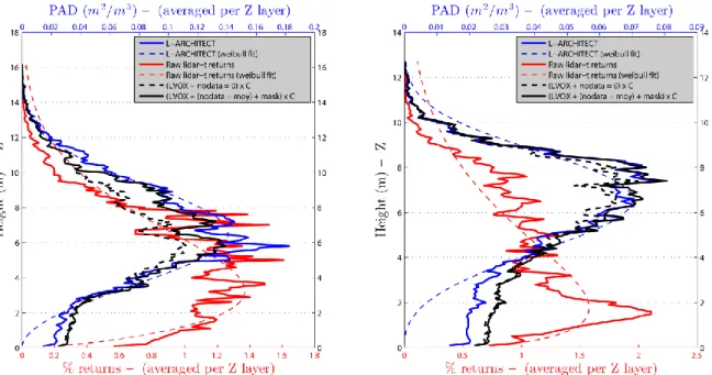
Figure
Documents relatifs
Paul Schmidt Yanez, Rodolphe Rougerie, Annie Bézier, Béatrice Courtial, Christophe Bouget, Laurent Larrieu, Douglas W.. Herniou,
infccliwl diJeucs of grealesl coot:em iD lbe Kl'PR is fOOl--.l-tnooIll disetie (l'MD) ...·hich i•• hiply conlagiooo,.. bul ruely f'lal vi ....1 dise.e alfeaing cJoven
The ecological groups were obtained by a cluster analysis based on species diameter growth rates, their mortality rates and recruitment rates.. A forest dynamics matrix model was
This paper addresses this question through a case study in Wales, which aims to: (1) assess how beliefs in climate change in the private sector have influenced forest manage-
The characterization of all CAS-based subtypes is given in tables (structural statistics) and figures (density and basal area distributions across diameter and height clas- ses) of
We propose an Online Method Engine (OME) that can not only be used to store and retrieve method fragments, but also to assess an organization’s current processes, create an advice
The carbon stocks were measured in the soil, humus and vegetation components, at sampling points distributed throughout the forest massif, and then the data were extrapolated to
This study describes a novel validation procedure of real-time PCR based on accuracy profile to estimate bacterial concentrations in fecal samples.. To assess the performance of
