HAL Id: cea-02570827
https://hal-cea.archives-ouvertes.fr/cea-02570827
Submitted on 12 May 2020HAL is a multi-disciplinary open access
archive for the deposit and dissemination of sci-entific research documents, whether they are pub-lished or not. The documents may come from teaching and research institutions in France or abroad, or from public or private research centers.
L’archive ouverte pluridisciplinaire HAL, est destinée au dépôt et à la diffusion de documents scientifiques de niveau recherche, publiés ou non, émanant des établissements d’enseignement et de recherche français ou étrangers, des laboratoires publics ou privés.
A global review of sediment source fingerprinting
research incorporating fallout radiocesium (
137Cs)
O. Evrard, Pierre-Alexis Chaboche, Rafael Ramon, Anthony Foucher, J.
Patrick Laceby
To cite this version:
O. Evrard, Pierre-Alexis Chaboche, Rafael Ramon, Anthony Foucher, J. Patrick Laceby. A global review of sediment source fingerprinting research incorporating fallout radiocesium (137Cs).
1
A global review of sediment source fingerprinting research incorporating fallout radiocesium (137Cs)
1
Olivier Evrard1, Pierre-Alexis Chaboche1, Rafael Ramon1, 2, Anthony Foucher1, J. Patrick Laceby3 2
1
Laboratoire des Sciences du Climat et de l’Environnement (LSCE/IPSL), Université Paris-Saclay, UMR 3
8212 (CEA-CNRS-UVSQ), Gif-sur-Yvette, France 4
2
Graduate Program in Soil Science, Federal University of Rio Grande do Sul, Bento Gonçalves Av., 5
91540-000 Porto Alegre, RS, Brazil 6
3
Environmental Monitoring and Science Division, Alberta Environment and Parks, 3115 – 12 Street 7
NE, Calgary, Alberta, Canada 8
Abstract
9
Information on the main sources supplying deleterious sediment loads to river systems is needed to 10
improve our understanding of soil erosion processes. In particular, it is important to quantify the 11
respective contributions of surface and subsurface sources to material degrading waterbodies. 12
Radiocesium (137Cs), emitted during thermonuclear bomb testing (~1950–1980) and nuclear 13
accidents provides significant discrimination between surface material exposed to atmospheric 14
fallout and subsurface material sheltered from it. A systematic worldwide review of research articles 15
(n=123) that used 137Cs to trace sediment sources showed that the United Kingdom (n=24), Australia
16
(n=23) and the United States (n=20) had the highest number of publications utilizing 137Cs in a 17
sediment tracing framework. In contrast, few studies were published for catchments in Africa (n=9) 18
or South America (n=2). In the northern hemisphere, positive relationships were evident between 19
137
Cs activities in surface and subsurface sources and the proportion of thermonuclear bomb fallout. 20
However, given the low proportions of fallout received in regions between 0–20°N and 0–20°S, the 21
potential application of 137Cs tracing techniques may be limited in this area of the world as well as in 22
agricultural regions with severe soil erosion (i.e. Chinese Loess Plateau and South Africa). In total, 23
94% of the studies researching surface and subsurface sources that analyzed 137Cs as a potential 24
tracing property included this parameter in end-member mixing models. The main challenges for the 25
future of this technique are mainly related to the access to ultra-low background gamma 26
spectrometry facilities and the development of surrogate tracers. Future research should ensure that 27
basic catchment information and details on the sampling design are properly documented to ensure 28
studies are reproducible. Moreover, researchers should provide raw measurement data to help 29
improve our global understanding of 137Cs dynamics in soil erosion research. 30
31
Keywords: watersheds; soil erosion; sediment tracing; fallout radionuclides.
32 33
Highlights
34
The meta-analysis compiled 123 articles considering 137Cs for sediment tracing 35
70% of these studies were conducted in Europe, North America and Australia 36
Fallout levels are too low in regions near the Equator and with extensive erosion 37
137
Cs was included in 71 to 94% of studies modelling source contributions 38
Future research should systematically include details on sampling design 39
40
*Manuscript with line numbering and double line spacing
2
1. Introduction
41
Exponential population growth and the concomitant expansion and intensification of our global 42
anthropogenic footprint has resulted in an unsustainable and non-renewable loss of soil resources 43
threatening United Nations Sustainable Goals (e.g. food security) (Keesstra et al., 2016). To limit soil 44
loss, best management practices need to be applied to landscapes degraded by accelerated soil 45
erosion processes generating significant sediment loads that impair downstream aquatic systems 46
(Owens et al., 2005). Accordingly, identifying the main areas of soil erosion is a prerequisite to 47
improve our knowledge of the main factors driving soil erosion processes and guide the 48
implementation of best management practices. 49
One approach that effectively identifies areas with elevated soil erosion rates is the sediment tracing 50
or sediment source fingerprinting technique (Haddadchi et al., 2013; Owens et al., 2016; Walling, 51
2013). This technique is increasingly used around the world to quantify sediment source 52
contributions based on the measurement of biogeochemical and/or physical properties in both soils 53
and sediment through the use of statistical procedures and un-mixing models (Haddadchi et al., 54
2013; Koiter et al., 2013b; Walling, 2005). Effective sediment tracer properties, or fingerprints, must 55
significantly differentiate between potential sediment sources and behave conservatively during 56
erosion, transport and deposition processes, or vary in a predictable and measurable way (Koiter et 57
al., 2013b; Laceby et al., 2017; Smith and Blake, 2014). Although a variety of tracing parameters have 58
been utilized in sediment source fingerprinting research (e.g. element geochemistry, colour 59
parameters, magnetic properties, organic matter parameters), fallout radionuclides that originate 60
from the atmosphere and are quickly and strongly bound to fine particles provide a notably powerful 61
tool to investigate soil erosion sources and sediment transfer processes (Mabit et al., 2008). 62
In particular, caesium-137 (137Cs; T1/2 = 30 y) is often used to identify whether sediment has been
63
generated by surface or subsurface erosion processes. This fallout radionuclide was mainly supplied 64
to exposed soils during atmospheric thermonuclear bomb testing between the 1950s and the 1970s, 65
with a peak in 1963 and 1965 in the northern and southern hemispheres, respectively (Arnaud et al., 66
2006; Cambray et al., 1989; Turney et al., 2018). Accordingly, surface soils exposed to atmospheric 67
fallout are typically enriched in 137Cs, while subsurface soils (e.g. gullies and channel banks) that were 68
sheltered from direct fallout are typically depleted in 137Cs (Campbell et al., 1985; Loughran et al., 69
1982; Peart and Walling, 1988). 70
In the 1980s, researchers investigated the utility of using 137Cs to discriminate between potential 71
sediment sources in Australia (Campbell et al., 1985; Loughran et al., 1982) and in the UK (Peart and 72
Walling, 1988). As 137Cs is concentrated near the soil surface, sediments eroded from rill or sheet 73
erosion processes typically have 137Cs concentrations that are higher than sediments eroded from 74
subsurface erosion processes, with erosion on cultivated soils plotting between these two potential 75
3 source end-members (He and Walling, 1995; Wallbrink and Murray, 1993). Walling and Woodward 76
(1992) were the first to use un-mixing models demonstrating the potential to capitalize on the 77
consistent differences of 137Cs in these potential source soils and quantify their contributions to 78
sediment sampled in waterways. 79
Several review papers have recently been published on sediment tracing techniques in general 80
(Haddadchi et al., 2013; Koiter et al., 2013b; Owens et al., 2016; Walling, 2013), or on fallout 81
radionuclides in particular (Mabit et al., 2014; Matisoff, 2014; Taylor et al., 2013). However, these 82
reviews have not provided a structured and comprehensive worldwide synthesis of 137Cs utilized as a 83
tracer in sediment source fingerprinting research. Accordingly, this literature review was based on a 84
Web of Science search to provide structure to our meta-analysis of articles incorporating 137Cs in 85
sediment fingerprinting research to help facilitate the future application of this tracer worldwide. In 86
particular, the advantages and drawbacks associated with the use of 137Cs in sediment source 87
fingerprinting research are highlighted and perspectives for future research investigating sediment 88
source contributions with 137Cs are outlined. Overall, this fallout radionuclide has significant potential 89
to help guide targeting best management practices to reduce the effects of accelerated soil erosion 90
worldwide. 91
2. Literature overview
92
Journal articles using cesium-137 published in the English language were pulled from the Web of 93
Science up to 30 August 2019. The search keywords ‘cesium-137’, ‘137Cs’, ‘fallout radionuclides’, 94
‘sediment’ and ‘tracing’ or ‘fingerprinting’ were used in isolation and/or in combination. 95
2.1 Study areas 96
In total, the database comprised investigations conducted in 215 catchments from 123 journal 97
articles. Studies conducted in the UK represented almost one fifth (19%) of the articles in the 98
database. The large contribution of the British studies is likely explained by the pioneer work initiated 99
by the research team of Professor Desmond Walling at the University of Exeter, and his former PhD 100
students who continued in research after their theses. 101
Overall, studies conducted either in Europe or in North America constituted 52% of the articles. In 102
North America, the work conducted in the US clearly dominates (representing 80% of the articles in 103
this region). In Europe, outside of the UK, the countries with the largest number of articles were 104
Spain (n=8) and France (n=6). Research carried out in Asia contributed to 20% of the articles (n=25), 105
with the highest number of articles published in Japan (n=5) and China (n=5). A significant number of 106
articles were published in Australia (n=23; 19% of the world total), including several papers that 107
provided methodological background on the use of fallout radionuclides as fingerprints (Murray et 108
al., 1993; Olley et al., 1993; Olley et al., 1996; Wallbrink et al., 1999). Although soil erosion is 109
widespread in Africa and South America (Anache et al., 2017; Vanmaercke et al., 2014), very few 110
4 studies were conducted on these continents (Africa 7%, n=9; South America 2%, n=2). When 111
mapping locations where 137Cs was measured (Fig. 1), a clear dominance of research conducted in 112
the US, Europe and along the eastern coast of Australia is demonstrated. 113
2.2. Research Design 114
Most papers (93%) provided summary information on their catchments or study locations. For those 115
catchments where the surface area was provided, the mean surface area was 3859 km² (standard 116
deviation (SD) 17,630 km2), with this relatively high value being impacted by the large surface area of 117
several studies in Australia (up to 130,000 km²). 118
The study design was strongly variable with the source numbers ranging between six and 893 (mean: 119
123; SD: 150; median: 70), corresponding to a mean source density of 47 samples per km2. Although 120
the most common sampling procedure was the collection of the uppermost 0–2 cm soil layer (n=39 121
articles), multiple strategies were employed including sampling the 0–5 cm (n=25), 0–1 cm (n=9), 0– 122
10 cm (n=4) or 0–2.5 cm (n=2) of surface soils. Sediment collected on hillslopes was used as a 123
surrogate for source material in six studies. This technique may be useful to facilitate the direct 124
comparison of source and sediment characteristics. Soil profiles were used to characterise sources in 125
nine articles. Unfortunately, information on the source sampling depth was not provided in a large 126
number of studies (n=34, 28%). 127
Sediment samples mainly consisted of suspended matter (n=31 articles), core(s) collected in lakes, 128
reservoirs or floodplains (n=18), bed material (n=18), material collected in sediment traps or ‘time-129
integrated samplers’ (n=14) often based on the design proposed by Phillips et al. (2000), lag deposits 130
(n=6) or a combination of a least two of the previous options (n=14). Of note, information on the 131
type of sediment collected was not mentioned in 22 studies (18%). The number of sediment samples 132
analysed strongly varied among studies, from four to 345 samples (mean: 48; SD: 61; median: 28). Of 133
note, this information was not provided in 40 studies (33%). 134
Regarding particle size, the < 63 µm fraction was by far the most common (n=57 articles), followed by 135
the < 2 mm fraction (n=28). A limited number of studies analysed the <10 µm fraction (n=9). Of note, 136
among these nine studies, eight were carried out in Australian catchments. Only three studies 137
investigated multiple particle size fractions. Occasionally, other particle size thresholds were used 138
(<200 µm, n=2; <250 µm, n=2). Information on the particle size fraction analysed was not provided 139
for 22 studies (18%). 140
Overall, the number of studies analysing 137Cs in tracing research in order to quantify sediment 141
source contributions increased from only 1.2 articles per year between 1988–1998 to seven articles 142
per year between 2009–2019 (Fig. 2) demonstrating the increasing popularity of this technique. 143
5
3. Spatial patterns of 137Cs deposition across the world
145
The deposition of 137Cs reached a peak in 1963 and 1965 in the northern and southern hemispheres, 146
respectively (Fig. 3). Fallout became negligible after 1980 when China stopped testing nuclear 147
weapons. There are localized exceptions, including most regions of Europe (Evangeliou et al., 2016) 148
affected by the 1986 Chernobyl fallout and several Prefectures in Japan that received significant 149
fallout following the Fukushima Dai-ichi Nuclear Power Plant accident in 2011 (Saito and Onda, 150
2015). However, even in areas affected by accidental fallout, this additional 137Cs supply did not 151
fundamentally affect the ability of this radionuclide to discriminate surface sources, enriched in 137Cs, 152
and subsurface sources, sheltered from the main fallout (Evrard et al., 2016). 153
Data available from the United Nations Scientific Committee on the Effects of Atomic Radiation 154
(UNSCEAR) demonstrate that the majority of the fallout occurred in the Northern Hemisphere 155
(~77%), relative to the Southern Hemisphere (~23%)(UNSCEAR, 2000). The results of long-term 156
monitoring programmes of global fallout deposition were compiled to estimate the proportion of 157
global fallout through worldwide networks operated by the Environmental Measurements 158
Laboratory (EML) in the United States (Health and Safety Laboratory, 1977). Deposition densities at 159
individual sites were averaged out for each 10-degree latitude band and multiplied by their area to 160
obtain global deposition amounts. However, a significant proportion of data is lacking, and this 161
spatial distribution should therefore be taken with caution (Fig. 4). 162
To compare surface and subsurface 137Cs activities, data available from articles compiled in the 163
current research were decay-corrected to 1 January 2019 (based on the sampling/reference date 164
when it was provided or based on the 5-yr mean duration calculated in the current research between 165
sampling and publication). To provide a worldwide basis for comparison of those activities, the mean 166
137
Cs activities reported for cultivated topsoil versus subsurface sources (i.e., gullies, badlands and 167
channel banks) were grouped in 10° latitudinal bands and compared to the proportion of fallout 168
received in each band after UNSCEAR (2000). Overall, a positive relationship is observed between the 169
mean 137Cs activities in surface (Fig. 5a) and subsurface (Fig. 5b) sources and the proportion of total
170
fallout received in each latitudinal band of the Northern Hemisphere (0.62 < r2 < 0.68). 171
In the southern hemisphere, a positive relationship between the mean activities in the topsoil 172
sources (Fig. 5c) or the subsurface sources (Fig. 5d) and the proportion of fallout received is also 173
found from the Equator to the southern latitude. However, given the low quantity of data compiled, 174
these relationships should be taken with caution. The higher uncertainties are likely due to the lower 175
quantity of data available and their concentration between 0°-10°S and 30°-40°S in the southern 176
hemisphere where 55 and 51% of missing data were calculated, respectively (Fig. 4). 177
In both hemispheres, a positive relationship was found between the mean 137Cs activities in 178
surface/subsurface sources and the increasing latitudes. However, the relatively large dispersion of 179
6 values found at similar latitudes may prevent the direct use of these relationships for characterizing 180
137
Cs activities in surface and subsurface sources (Fig. 6). The variations observed at similar latitudes 181
may be explained by local factors (e.g. slope, orientation) and differences of land uses (cultivated vs. 182
uncultivated) or farming practices (e.g. tillage vs. no-tillage) leading to varying levels of soil erosion. 183
This data clearly demonstrates that in 2019, 137Cs activities are sufficiently high in surface sources in 184
areas located above 20°N and below 20°S to be relatively easily detectable with low-background 185
gamma spectrometry equipment (Fig. 6). In contrast, for most areas located around the Equator (i.e. 186
between 20°N and 20°S), 137Cs activities in surface soils are likely to be very low (often < 2 Bq kg-1) 187
and may therefore be increasingly difficult to differentiate from subsurface sources, which are 188
generally lower than 1.5 Bq kg-1. 189
4. Spatial applicability of 137Cs based-tracing across the globe
190
Although most of the studies using 137Cs were conducted in North America, Europe and along the 191
eastern coast of Australia, evidence exists in the literature to outline areas where there is potential 192
to use this radionuclide in sediment tracing studies and regions where 137Cs concentrations are not 193
sufficient and/or will soon become too low to conduct this type of research. As 137Cs is preferentially 194
bound to the finer particle size fractions (He and Walling, 1995), the method should be applied at 195
locations where sediment contains significant amounts of clay and silt. 196
In the Northern Hemisphere, where 77% of the total fallout is estimated to have occurred (UNSCEAR, 197
2000), this technique should be applicable to most regions of Europe and North America. In the 198
studies reviewed, no problems were reported for the detection of 137Cs in these regions. 199
Furthermore, the 137Cs-based technique to discriminate between surface and subsurface sources 200
should be applicable in areas exposed to Chernobyl fallout, as subsoils were sheltered from 201
atmospheric fallout (Belyaev et al., 2013). As the 137Cs technique has been extensively applied in 202
Europe and North America, our review here will focus on contexts where there has been less 203
application of this tracing technique. 204
In Asia, a variety of environmental contexts may complicate the utilization of 137Cs to trace surface 205
and subsurface sources. On China’s Loess Plateau, soil erosion is so extensive that Li et al. (2017) 206
used 137Cs to discriminate between sediment derived from gully areas (activities ~1.5 Bq kg-1) and 207
inter-gully areas (activities ~0 Bq kg-1). These results demonstrate that 137Cs will soon no longer be 208
detectable in this type of environment exposed to very high erosion levels. In contrast, significantly 209
higher 137Cs activities were detected in the black soil region of Northeast China, both in cultivated 210
land (mean: 2.0 Bq kg-1) and in gully areas (mean 0.3 Bq kg-1), despite the fact that this region was 211
also exposed to high soil degradation over the last several decades. Similar 137Cs activities (~2 Bq kg-1) 212
were detected in a catchment of the Sichuan Province (Tang et al., 2014) and the surface and 213
7 subsurface tracing method was also demonstrated to be applicable in the Upper Yangtze River basin 214
(Long et al., 2012). 215
In Japan, 137Cs may still be used to discriminate between different sources of sediment, even after 216
the Fukushima Dai-ichi Nuclear Power Plant accident in low-fallout areas (Ochiai et al., 2015). The 217
shorter-lived 134Cs isotope (t1/2 = 2 y) is also detectable in this post-accidental context, which may
218
provide discrimination between the global fallout 137Cs and the additional 137Cs Fukushima fallout, as 219
the 134Cs deposited after the thermonuclear bomb tests conducted in the 1960s is no longer 220
detectable. Background information on 137Cs activities prevailing in Japanese soils before the 221
Fukushima Dai-ichi Nuclear Power Plant accident is available in the literature as sediment tracing 222
techniques based on fallout radionuclides were conducted in forested (Fukuyama et al., 2010) and 223
agricultural (Ahn et al., 2009) catchments in Japan before 2011. The only other region of the world 224
where significant levels of 134Cs (and hence of extra 137Cs) originating from Fukushima accident were 225
reported is Hawaii, although this 134Cs fallout will rapidly decay to undetectable levels (McKenzie and 226
Dulai, 2017). 227
In other Asian countries, sediment sources collected in a catchment in South Korea discriminated 228
between channel banks (mean 137Cs activities of 2.2 Bq kg-1) and forest soil sources (mean 13.5 Bq kg -229
1
) (Lim et al., 2014). Another successful approach was conducted in a forested catchment of South 230
Korea (Kim et al., 2013). The applicability of the approach in Taiwan was also demonstrated in a 231
study conducted in a catchment covered with tea plantations (Zehetner et al., 2008). In contrast, in a 232
catchment of Central Thailand, 137Cs activities were systematically < 1 Bq kg-1 for all sources (i.e., 233
uncultivated, cultivated and pasture soils)(Srisuksawad et al., 2015). These results differed with those 234
obtained in a study conducted in Eastern Indonesia, where surface (mean: 1.9 Bq kg-1) and 235
subsurface (< 0.3 Bq kg-1) source contributions could be discriminated based on their 137Cs fallout 236
activities (Hobgen et al., 2014). Surprisingly, only two studies using 137Cs for tracing sediment source 237
contributions were found in India (Froehlich, 2004; Froehlich and Walling, 2006). 238
In the Southern Hemisphere, where less fallout is estimated to have occurred (~23%) (UNSCEAR, 239
2000), much less information is available regarding areas where the method is applicable. In Africa, 240
this technique was shown to be applicable in Tunisia (Ben Slimane et al., 2013) as well as in Burkina 241
Faso (Rode et al., 2018). This suggests that the technique can be used in the Maghreb and Sahel 242
countries, at least in areas where soils are not too sandy. In addition, sufficient 137Cs levels were 243
found in Zambia despite this country being located at a relatively low latitude (~16°S) (Walling et al., 244
2001). 245
Depending on the region, numerous areas in the Southern Hemisphere had high levels of soil 246
degradation associated with the arrival of European settlers (i.e. from the early 19th century in South 247
Africa), which likely led to the rapid erosion of the upper soil layers tagged with 137Cs. In South Africa, 248
8 Foster et al. (2017) measured low and highly variable 137Cs contents (2 ± 2 Bq kg-1) in topsoil, 249
particularly in catchments having variable soil cover on steep rocky hillslopes. The difficulty in using 250
137
Cs as fingerprint was also demonstrated by van der Waal et al. (2015) who detected 137Cs in only 251
50% of 28 surface soil samples collected from a small catchment in the Drakensberg mountain range 252
region. 253
In contrast, in South America, higher levels of fallout radionuclides were found in an agricultural 254
catchment of Southern Brazil (Minella et al., 2014) and in forested catchments of Chile (Schuller et 255
al., 2013). The extremely low number of studies (n=2) considering 137Cs as a potential source 256
fingerprint in South America shows the large development potential existing in this region for the 257
future. This is particularly true in those regions located below 20°S (i.e. Argentina, Chile, Paraguay, 258
Uruguay and the southernmost part of Brazil) where 137Cs activities exceeding 2 Bq kg-1 should be 259
widely found in surface sources. 260
In Oceania, this technique was mainly applied to catchments (n = 40) located along the eastern coast 261
of Australia (Krause et al., 2003; Olley et al., 2013b; Wilkinson et al., 2013). Significant and detectable 262
137
Cs activities were found in surface sources, including managed or unmanaged forests, grazed or 263
unmanaged pastures, cropland and bushland, which were easily differentiated from subsurface 264
sources including gullies and channel banks that were totally depleted in 137Cs. One exception was a 265
mining catchment of New Caledonia, South Pacific Islands, where the very low 137Cs activities 266
measured in mining and non-mining tributaries indicated the dominance of subsurface sources in the 267
sediment contribution in this region. Given much higher activities were measured at similar latitudes 268
in Australia, these low activities likely reflect the intensity of soil erosion processes and the 269
dominance of subsoil erosion on this island (Sellier et al., 2019). 270
5. Applications of 137Cs in sediment source fingerprinting research
271
Fifty studies (41%) used 137Cs to discriminate between surface and subsurface contributions (Table 1). 272
In contrast, 49 studies (40%) used 137Cs to discriminate between land use contributions to sediment 273
(Table 2). Other approaches investigated the contributions of sub-basins or tributaries (n=4), areas 274
with different geologies (n=3), or different erosion processes (gully vs. rill or sheet erosion; n=2). 275
Finally, 13 studies (11%) examined multiple combinations of these approaches (Table 3). 276
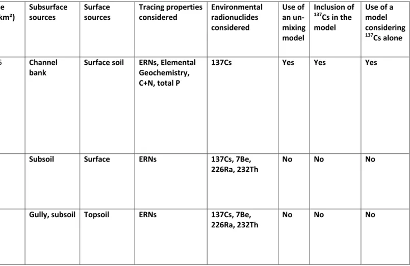
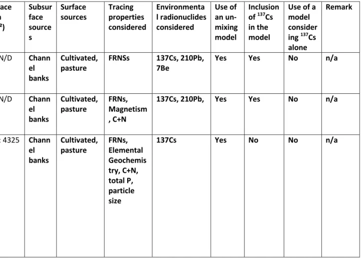
5.1 Surface versus subsurface erosion 277
Subsurface sources generally included channel banks (n=27 studies) and/or gullies (n=22). Much less 278
often, landslides (n=3), unpaved roads (n=2), or construction sites (n=2) were also considered as a 279
dominant subsurface source (Table 1). In addition to 137Cs, researchers often utilized other 280
environmental radionuclides (ERNs) to discriminate between surface and subsurface sources, 281
including: 210Pbxs (n=32 studies), 7Be (n=11), 226Ra (n=5), 232Th (n=4), 40K (n=4; Table 4). Plutonium
9 isotopes were also measured in three articles, with different isotopes or ratios analysed 283
(238Pu/239+240Pu, 239Pu, 239+240Pu). In Japan, one study also detected 134Cs emitted during the Fukushima 284
Dai-ichi Nuclear Power Plant accident (Ochiai et al., 2015). Belmont et al. (2014) also examined 10Be 285
concentrations to take into account the long-term deposition and remobilisation of sediment 286
between the floodplain and the main river channel. 287
Often, researchers only use 137Cs to discriminate between surface and subsoil sources. In many 288
studies, 137Cs alone provided powerful discrimination between sediment originating from subsurface 289
areas or from surface material. For instance, from a catchment in Oklahoma State (US), 12-fold 290
higher levels of this radionuclide were found in ‘overland’ material compared to samples collected in 291
gully areas (Zhang et al., 2016). 292
However, several small-scale studies conducted in the early 1990s in Australia showed that the 293
combination of several radionuclide measurements (i.e. 7Be, 210Pbxs and 137Cs) provided additional
294
information to distinguish between different erosion processes (e.g. sheetwash vs. rill erosion) based 295
on their different depths of penetration or their mixing in the soil (Wallbrink et al., 1999). This 296
approach was further developed to be effective at the catchment scale. For instance, the 297
combination of the three fallout radionuclides was used to compare the effects of tillage vs. no-298
tillage management of cropland on soil erosion and sediment yields in the US, because these 299
different farming practices lead to different penetration/mixing depths of the radionuclides in the 300
soil (Matisoff et al., 2002). In Australia, Hancock et al. (2014) showed that the use of 7Be provided a 301
way to discriminate between vertical (i.e. channel banks, depleted in 7Be) and horizontal (i.e., rills, 302
scalds, gully floors, enriched in 7Be) subsoil erosion sources. 303
In addition to ERNs, the most commonly used tracing properties were elemental geochemistry (n=6 304
studies), total carbon and/or nitrogen (n=6), magnetic properties (n=5), total phosphorus (n=3), δ15N 305
and δ13C (n=2), and 87Sr/86Sr (n=1). From the 50 articles examining the surface vs. subsurface 306
contributions to sediment, 18 studies did not use mixing models. Among the 32 studies that did apply 307
a source apportionment model, only two articles did not include 137Cs in the final tracer combination 308
included in the mixing models. 309
5.2 Soil erosion on different land uses 310
Articles discriminating between land use contributions to sediment (n=49) mainly focused on the 311
material supplied by cropland/cultivated land (n=40), channel banks (n=34), forests (n=24) and 312
grassland/pasture (n=22). Other subsurface sources included gullies (n=11), roads (n=11) and 313
badlands (n=4) along with other surface sources included shrubland (n=4) and rangeland (n=3) (Table 314
2). 315
10 To discriminate this variety of sources, a number of potential tracing properties were examined. In 316
addition to 137Cs, other ERNs considered were 210Pbxs (n=30 articles), 226Ra (n=16), 7Be (n=7), 40K (n=8),
317
232
Th (n=6)(Table 2). Regarding the other types of properties examined, elemental geochemistry was 318
the most frequent (n=33) followed by total carbon and nitrogen (n=22), total phosphorus (n=13), 319
magnetic properties (n=10) and phosphorus fractions (n=3). Only one study analysed δ15N 320
(Mukundan et al., 2010) in conjunction with 137Cs. Only five studies remained descriptive and did not 321
apply an un-mixing model to quantify the land use contributions to sediment. Among those that 322
modelled the sediment source contributions, 35 articles (71%) included 137Cs in the optimal tracer 323
combination in at least one of the investigated catchments. 324
Interestingly, the use of 137Cs was not restricted to the discrimination between surface and 325
subsurface sources, and it sometimes provided further discrimination between other land use types 326
such as scrubland enriched in this radioisotope compared to forest areas depleted in 137Cs, 327
depending on the magnitude of erosion processes occurring in these potential sources (Palazón et 328
al., 2015). Of note, the 137Cs signature of different land uses may change with time in response to the 329
soil erosion processes. In Laos, the replacement of slash-and-burn traditional cultivation with 330
commercial teak plantations on steep hillslopes generated so much soil erosion, that the 331
corresponding source signature switched from a typical surface soil 137Cs activity (mean: 2.5 Bq kg-1) 332
to that of a subsurface soil (mean: 1.1 Bq kg-1) in less than 20 years (Ribolzi et al., 2017). 333
The impact of changes in human practices on soil erosion may also be reflected by fallout 334
radionuclide measurements. For instance, the reduction of cattle grazing pressure in Australian 335
catchments was demonstrated to have led to a decline in both surface and subsurface soil erosion 336
rates (Wilkinson et al., 2013). In another context, among other properties, 137Cs also contributed to 337
estimate the impact of forestry operations including clearcutting, tree harvest and replantation on 338
sediment source contributions in catchments of Chile (Schuller et al., 2013). 339
5.3 Impacts of Roads on Soil Erosion 340
The role of unsealed or unpaved roads has been investigated in 15 articles across several regions of 341
the world, including Australia (n=3), Brazil (n=1), Burkina Faso (n=1), France (n=1), India (n=1), Iran 342
(n=1), Japan (n=1), Mexico (n=1), South Korea (n=1), the UK (n=1) and the US (n=2) (Table 2). The 343
road contribution to sediment can reach 20 to 500 times the areal contributions from forests (Motha 344
et al., 2004; Motha et al., 2003) as road construction may rapidly accelerate soil erosion. For 345
instance, the building of a highway in Oahu, Hawaii, was shown to significantly increase the fine 346
sediment supply to the river (Hill et al., 1998). Soil erosion was also shown to be particularly intense 347
on the truck trail network, depleted in fallout radionuclides, in Japanese cypress plantations 348
(Mizugaki et al., 2008). In a catchment of Iran, it was shown that 137Cs provided discrimination 349
between channel bank (mean: 2.7 Bq kg-1) and road cuttings (mean: 1.0 Bq kg-1). This finding was 350
11 mainly attributed to the fact that channel banks likely consisted of a mixture of surface and 351
subsurface material originating from upstream catchment locations (Nosrati et al., 2018). 352
5.5 Impacts of Wildfires 353
The use of 137Cs (n=6) and plutonium isotopes (n=1) was particularly helpful in catchments exposed 354
to wildfires, as other potential tracers including magnetic and geochemical properties were affected 355
by variable wildfire modifications in burned soils (Blake et al., 2006) (Table 1). Furthermore, 210Pbxs
356
was excluded from the list of the potential tracers because of its high apparent sensitivity to the 357
reduction in ash content in channel deposits compared to hillslope material (Smith et al., 2012). In 358
burned soils, increases in the concentration of 210Pbxs and 137Cs were widely found in response to the
359
combustion of organic matter and the redistribution of radionuclides to surface soil and ash 360
(Wilkinson et al., 2009), with a stronger effect for 210Pbxs for which ~30% of the total inventory may
361
be found in the surface litter of eucalyptus forests. In contrast, in unburned soils, 137Cs is mainly 362
associated with mineral soil due to bioturbation transferring decayed litter into the soil following the 363
cessation of 137Cs fallout in the mid-1970s (Wilkinson et al., 2009). 364
However, in the framework of a rainfall experiment conducted after a major forest fire in Los Alamos, 365
New Mexico (US), Johansen et al. (2003) found 137Cs concentrations that were 40 times higher in ash 366
deposits and three times higher in the topmost 5 cm of soil compared to pre-burned soils. 367
Concentration of 137Cs in sediment was also observed when soil erosion occurred, although the levels 368
declined rapidly with time and returned to the pre-fire levels after ~250 mm of cumulative rainfall. 369
Smith et al. (2013) provided a comprehensive review showing the techniques that may be used to 370
discriminate fine sediment sources in burned catchments, with numerous examples taken in North 371
America and in Australia. Additional sediment tracing approaches have since been conducted in 372
catchments exposed to fires in other regions of the world including the Mediterranean region (e.g., 373
the Balearic Islands, Spain). The occurrence of higher fallout radionuclide levels in burned material 374
compared to unburned sources was also observed in these regions (Estrany et al., 2016; García-375
Comendador et al., 2017). 376
5.6 Use of fallout radionuclides in tile-drained catchments 377
Another type of environment where particularly high 137Cs activities were detected in source material 378
corresponds to drained catchments (n= 3) (Table 2). In a catchment located in the centre of France, 379
Foucher et al. (2015) used 137Cs measurements to demonstrate that sediment transferred in these 380
drains originated predominantly from surface sources. They also outlined a substantial enrichment of 381
very fine particles (~2–4 µm) in the drains and proposed an original correction factor based on Th 382
concentrations estimated based on the 228Th activities, which are analysed along with 137Cs by 383
gamma spectrometry. Similar substantial particle size differences were observed by Russell et al. 384
(2001) in drained catchments of the UK, where they also found significant proportions of sediment 385
12 originating from surface sources, although they underlined that their results were constrained by the 386
representativeness of the study periods. 387
5.7 Use of fallout radionuclides in urban catchments 388
Relatively few studies (n=6) investigated sediment source contributions in urban catchments (Table 389
2). Among the few studies that used 137Cs measurements, Ormerod (1998) calculated an increase in 390
subsurface supply to sediment in downstream direction in a study conducted in New South Wales, 391
Australia. In the UK, Carter et al. (2003) included 137Cs among a suite of properties to discriminate 392
between channel banks, cultivated or uncultivated topsoils and two urban sources (i.e road dust and 393
solids from sewage treatment works). Devereux et al. (2010) illustrated the difficulty to define an 394
urban signature except for the road surfaces or what was referred to as ‘street residue’ in a US 395
catchment. In Laos, an increase in the contribution of subsurface material supplied by the river was 396
also attributed to subsoil exposed to rainfall in constructions sites in suburban areas (Huon et al., 397
2017). Finally, in a tributary of the Seine River (France), Froger et al. (2018) quantified the 398
contribution of ‘road deposited sediment’ to the material transiting this river. Relatively depleted in 399
137
Cs (median activity: 0.5 Bq kg-1), this source was strongly enriched in 210Pbxs (median: 232 Bq kg-1)
400
and 7Be (median: 402 Bq kg-1) and was shown to supply significant quantities of metal contaminants 401
originating from urban runoff to the river. These studies illustrate that there is potentially an 402
untapped potential of 137Cs research in urban catchments. 403
6. Main challenges associated with the use of 137Cs as a tracer
404
6.1 Particle size 405
In the early 1990s, Walling and Woodward (1992) already recommended the community to take into 406
account the particle size enrichment of 137Cs when comparing the signatures of sources and sediment 407
material, and suggested to conduct particle size corrections (He and Walling, 1996). Indeed, the 408
universal use of these corrections has received critiques (Smith and Blake, 2014) and an extensive 409
review on the challenges and the opportunities associated with the tracer particle size effect have 410
been discussed in details (Laceby et al., 2017). In summary, it is well known that 137Cs is rapidly bound 411
to fine particle size fractions and that this enrichment must be carefully taken into account when 412
designing sediment source tracing studies. 413
6.2 Heterogeneity of source signatures 414
Often, research has demonstrated that there may be some local scale heterogeneity caused by 415
potential fallout deposition patterns or erosion patterns. On the one hand, 137Cs activities were 416
shown to vary significantly depending on the hillslope position based on a study conducted in Iran. 417
Accordingly, significantly higher 137Cs activities were found on the hillslope summit compared to the 418
shoulder position, as well as on the toeslope compared to the backslope and the shoulder. These 419
13 results demonstrate that when 137Cs is associated with other environmental radionuclides (i.e., 40K, 420
232
Th) and TOC, it may provide further detailed discrimination between different hillslope 421
compartments (Nosrati, 2017). On the other hand, 137Cs was used in a study investigating the spatial 422
variability of source properties (i.e. metals, trace elements, organic matter parameters) at the field 423
scale (Devon, UK) and provided information on the magnitude and the spatial patterns of soil 424
redistribution within the field that may cause in turn spatial variability in the fingerprint properties 425
(Du and Walling, 2017). This result corroborates the research of Wilkinson et al. (2015) in Australia 426
that demonstrated how sediment contributions of surface erosion in areas affected by high erosion 427
rates as estimated based on fallout radionuclide measurements may underestimate the topsoil 428
supply to sediment. Accordingly, these authors recommended to conduct source sampling schemes 429
stratified by erosion rate across the catchment, with the collection of a larger number of source 430
samples in highly eroded areas. 431
6.3 Situations where 137Cs was not selected as a relevant tracing property 432
Although 137Cs was successfully used in numerous studies, in some catchments including the suburbs 433
of Nanjing in China where extensive soil erosion occurs and several potential subsoil material sources 434
are found (i.e. roads, mines), the fallout radionuclide was not selected as a discriminant property 435
(Zhou et al., 2016). In an agricultural catchment of the Canadian Prairies, high 137Cs concentrations 436
were found in the top 0-20 cm layer of channel banks likely because this location corresponds to the 437
edge of the riparian soil that contains both original atmospheric fallout and also potentially 438
deposited material derived from upper parts of the catchment (Koiter et al., 2013a). Similar 439
difficulties were experienced by Boudreault et al. (2018) who measured similar 137Cs activities in 440
agricultural topsoil (mean: 7.2 Bq kg-1) and agricultural subsurface material (mean: 6.2 Bq kg-1) in a 441
catchment of New Brunswick (Eastern Canada). They also attributed this unexpected result to the 442
sampling protocol which consisted in collecting surface samples in depositional areas near the 443
stream edge or collecting channel bank aggregate samples from the top to the bottom of the profile 444
into a single sample. 445
6.4 Finding surrogate properties for 137Cs 446
Given the decay of 137Cs since the main fallout period during the last century and the difficulties to 447
detect this radionuclide in an increasing number of regions across the globe, surrogate properties 448
can provide discrimination of surface and subsurface sources to sediment in these environments. 449
Excess 210Pb 450
In catchments of South Africa, Foster et al. (2007) demonstrated the potential for 210Pbxs to provide
451
an alternative to 137Cs as the latter will soon become undetectable because of the lack of inputs and 452
its 30-yr half-life. A good relationship between both radionuclides was also found in source and 453
14 sediment samples collected in a catchment of Burkina Faso (Rode et al., 2018). A similar finding was 454
also demonstrated in a catchment of Southern England by comparing 137Cs and 210Pbxs activities in
455
surface, subsurface material and sediment (Walling and Amos, 1999), although the authors outlined 456
a greater enrichment in 210Pbxs than in 137Cs in suspended sediment and channel bank material
457
compared to subsoil material. This was attributed to a higher content of suspended sediment in 458
organic matter and the known preferential association of 210Pbxs with the organic fraction. Other
459
authors attributed this enrichment in 210Pb
xs in sediment compared to sources to the direct supply of
460
additional 210Pbxs fallout associated with rainfall in the channel (Wallbrink et al., 2002). Olley et al.
461
(2013b) indicated that the correlation that is often observed between 137Cs and 210Pbxs activities in
462
source samples implies that they should not be used to provide independent estimates of the 463
relative contribution of the sources to the river sediment. The comparison of the respective 464
proportions of 137Cs and 210Pbxs fallout per latitudinal band across the globe interestingly shows that
465
in low-latitude regions (0–20° latitude) where 137Cs fallout levels are very low, atmospheric 210Pb may 466
provide a surrogate tracer as it is continuously deposited at significantly higher levels than the initial 467
levels of 137Cs fallout (Fig. 7). 468
Other radionuclides 469
In early sediment tracing studies, 226Ra was measured along with 137Cs to discriminate between 470
topsoil and subsoil sources (Murray et al., 1993). Unlike most radionuclides, geogenic 226Ra was 471
found to be enriched in subsoil compared to topsoil in a catchment of Southeast Australia (Wallbrink, 472
2004). However, because of large variations in its concentrations, the use of this geogenic 473
radionuclide in tracing has never become extensive, despite early studies outlined its potential to 474
discriminate sediment sources at the plot scale in Southeastern Australia (Murray et al., 1993; Olley 475
et al., 1993). In a recent review article, Alewell et al. (2014) suggested that plutonium in general and 476
239+240
Pu in particular may provide the next generation tracer of soil redistribution due it is longer 477
half-life compared to 137Cs (Table 4) and its high measurement precision. 478
Organic matter 479
In catchments of South Africa where alternative tracers are actively sought given 137Cs in often below 480
the detection limits in topsoils across several regions, statistically significant correlations, with r2 481
values exceeding generally 90 %, were found between 137Cs and Loss-on-Ignition (LOI), which was 482
considered as a true reflection of organic matter and not C derived from bedrock or other sources 483
(Foster et al., 2017). The good relationship found between 137Cs and organic matter content in 484
potential source samples was also confirmed in a more recent study conducted in Iran (Nosrati et al., 485
2018). In Laos, Huon et al. (2013) showed that 137Cs activities and Total Organic Carbon 486
concentrations were better correlated in the topsoil (0–10 cm) compared to the deeper soil layers 487
(10–20 cm, 20–30 cm), illustrating that a common process – soil erosion – controlled their 488
progressive depletion in the surface layer. Based on a similar finding, surface and subsurface sources 489
15 were very well discriminated by both Total Organic Carbon and 137Cs in several catchments of the 490
Tunisian Ridge (Ben Slimane et al., 2016). Similarly, 210Pbxs activities were also shown to be well
491
correlated (r² = 0.79) with LOI measurements conducted in Australia (Olley et al., 2013a). However, in 492
another study conducted in Iran, uncertainties associated with sediment source contributions were 493
higher when using organic matter properties than when including 137Cs, likely because of the low 494
organic matter contents (mean: 0.3 – 0.4%) found in this arid region (Nazari Samani et al., 2011), 495
which illustrates that the validity of using this surrogate property should always be verified in the 496
local conditions prior to its application. 497
498
7. Limitations of the published 137Cs research
499
Only one paper provided its full dataset of raw measurement data (Le Gall et al., 2016) in the article 500
or in their Supplementary Material. For 13 articles, no data was given at all, and only those results of 501
statistical tests used for sediment tracing were provided. Often, a combination of graphs and tables 502
(n=31 studies) or only graphs (n=10) was provided. In a significant number of articles (n=54), only 503
statistics of the measurements were summarized in tables or simply referred to in the text. Fifteen 504
studies (7%) did not even provide information on the catchment area. Interestingly, information on 505
the source sampling depth was also not provided in a large number of articles (n=34). Of note, 506
information on the type of sediment collected was not mentioned in 22 studies and the number of 507
sediment samples was not even provided in 16 articles. Information on the particle size fraction of 508
interest was not provided for 22 articles published between 1996 and 2017, with 15 of those 509
published since 2010. As fallout radionuclides decay with time, the availability of the reference date 510
and/or the sampling date used for calculating their activities is of particular importance. However, 511
this information was lacking for 44 studies (36 % of the total), which may prevent the decay-512
correction of radionuclide activities at a later date or data comparison between studies. In the future, 513
researchers must include enough information in their articles to make them reproducible and 514
reviewers should ensure that this minimal standard is met. Furthermore, the provision of raw data 515
should also be encouraged in order to facilitate the incorporation of previous results when designing 516
new research projects and help improve our global understanding of 137Cs dynamics in soil erosion 517
research. 518
519
8. Perspectives for future research
520
With the decrease of 137Cs activities due to radioactive decay, the surface source activities will 521
increasingly become closer to those found in subsurface sources. Although this situation was already 522
observed in China’s Loess Plateau, in South Africa or in mining catchments of New Caledonia (Fig. 8), 523
16 its more frequent occurrence in the future will increase the uncertainties associated with this 524
method. The use of ‘well’ hyperpure germanium detectors installed in underground laboratories 525
sheltered from the cosmic rays could provide a temporary solution, but the use of these facilities will 526
not be accessible to a variety of researchers. Furthermore, the relatively high cost of gamma 527
spectrometry analyses and the need to collect sufficient material to conduct the analyses (e.g. using 528
a continuous flow mobile centrifuge) were outlined as potential difficulties associated with the use of 529
137Cs (Mukundan et al., 2010). The usual analysis time is 24 h per sample, although when low
530
quantities of material are available or for very low activity samples, counting times of 48 h per 531
sample are usual, which significantly decreases the analytical capacities and increases the unit cost 532
per analysis. 533
Based on the data compiled in the current research, 137Cs should theoretically provide powerful 534
discrimination between surface and subsurface sources of sediment in a large number of countries 535
across the world where this technique has not been tested yet (Fig. 8). In Europe, 137Cs has been 536
widely used for calculating sediment budgets based on the calculation of 137Cs inventories in soil 537
profiles (Mabit et al., 2013; Parsons and Foster, 2011) although it has been less often included in 538
sediment tracing research in Mediterranean countries as well as in the eastern and northern parts of 539
the continent. In Northern Africa, there should be significant potential for application in other 540
Maghreb countries as this technique was successfully implemented in Tunisia (Ben Slimane et al., 541
2016). In South America, the technique could be usefully tested in countries with a large agricultural 542
surface area and located > 20°S such as Argentina, Paraguay and Uruguay. Finally, in Oceania, 137Cs 543
could be tested as a fingerprint in New Zealand, in regions located in western and central Australia, 544
as well in other Pacific Islands (including French Polynesia). The applicability of the technique in 545
regions exposed to a colder climate could also be explored to investigate the impact of glacier retreat 546
on sediment source dynamics among other potential research topics. For example, the feasibility of 547
137
Cs detection has been recently demonstrated in Maritime Antarctica (Navas et al., 2017). 548
Although there has been a tendency in the literature to argue in favour of the development of 549
universal techniques and models that could be applied uniformly in catchments around the world, 550
the current research demonstrates that this goal will likely never be achieved with 137Cs owing to the 551
multiple environmental conditions, land use changes and the extent and variations of the 552
anthropogenic impacts observed in different catchments worldwide. Although universal principles 553
should be respected when implementing the sediment source tracing methods (i.e, comparing 554
similar particle size fractions of soils and sediment), there is no universal rule regarding the types of 555
the sources that can be discriminated based on the 137Cs method, whether this technique will work in 556
all the catchments or achieve the source differentiation that was initially sought. There will always be 557
a significant number of site-specific constraints that the researchers will have to identify and deal 558
with when deriving their sample design and when interpreting the data, which may lead to 559
17 unexpected results. For example, owing to its independence of lithology, 137Cs was considered a 560
useful property for distinguishing potential source types in catchments with heterogeneous geology 561
(Walling and Woodward, 1992). This characteristic was thought to be universal. However, the 562
diversity of applications and source type discriminations illustrated in the current research 563
demonstrate that the universality of one method will never reasonably be achieved owing to the 564
diversity of environmental contexts, anthropogenic activities and initial fallout levels found around 565 the world. 566 567 9. Conclusions 568
The current meta-analysis of research incorporating 137Cs in sediment source fingerprinting research 569
included 123 articles. Fifty-two percent of these articles provides results obtained in catchments 570
located in Europe or in Northern America. The three countries in the world with the highest numbers 571
of publications are the UK (n=24), Australia (n=23) and the US (n=20). In contrast, very few articles 572
reported research from Africa (n=9) and South America (n=2). The research design of these studies 573
was strongly variable, regarding the number and the size of the catchments investigated, or the 574
amount and the type of source and sediment samples analysed. The increasing number of studies 575
observed throughout time demonstrates the growing popularity of this technique. The atmospheric 576
thermonuclear bomb testing that reached a peak between 1963 (Northern Hemisphere) and 1965 577
(Southern Hemisphere) provided the main source of 137Cs fallout except in those few regions of the 578
world where nuclear accidents occurred (Chernobyl, Fukushima). However, this accidental fallout 579
does not prevent the use of 137Cs for discriminating surface vs. subsurface source contributions to 580
sediment in these regions. Overall, positive relationships were found between the 137Cs activities 581
found in surface/subsurface sources and the proportion of global fallout received. Given the low 582
proportions of global fallout received in those latitudinal regions located between 0-20°N and 0-20°S, 583
the applicability of the method may be increasingly limited in this part of the world. Furthermore, the 584
very low 137Cs activities found in surface soils analysed in China’s Loess Plateau and in South Africa 585
may prevent the use of this sediment fingerprinting technique in these regions and reflect the 586
severity of soil erosion processes occurring in these environments. 587
Forty-one percent of the reviewed studies included 137Cs for discriminating surface vs. subsurface 588
erosion, while 40% of the articles investigated land use contributions to sediment. The power of 137Cs 589
to distinguish between surface vs. subsurface sources was demonstrated by the fact that among 590
those studies that use un-mixing models, 94% included 137Cs in the optimal fingerprints included in 591
the models. For land-use based studies, 71% of those that modelled sediment source contributions 592
included 137Cs in the optimal tracer combination. The usefulness of this tracing property was also 593
demonstrated in catchments exposed to wildfires, urban environments and tile-drains. 594
18 Among the main challenges associated with this method, the ongoing decay of 137Cs to undetectable 595
levels raises the need to develop the use of detectors installed in underground laboratories and that 596
of alternative tracers that may include 210Pbxs, plutonium or organic matter properties. In the future,
597
researchers need to systematically include basic catchment information in their articles as well as 598
reproducible details on the sampling design including the number and the type of the source and 599
sediment samples collected, the sampling depth, the sampling/reference dates and the particle size 600
fraction considered. Furthermore, researchers should provide access to the raw data in order to 601
facilitate the incorporation of previous research results. Despite previous suggestions regarding the 602
development of universal techniques and models that could be applied uniformly in catchments 603
across the globe, the current meta-analysis demonstrates that this goal will likely never be achieved 604
as a result of the diversity of the environmental conditions and fallout levels found in catchments 605
around the world. 606
607
Acknowledgements
608
The ideas developed in this paper benefited from fruitful scientific discussions in the framework of 609
sediment fingerprinting sessions organized during the General Assembly of the European Geoscience 610
Union and the Fall Meeting of the American Geophysical Union. The authors are also grateful to 611
CAPES for funding the PhD scholarship of Rafael Ramon in the framework of the CAPES-COFECUB 612 Project No. 88887.196234/2018-00. 613 614 Supplementary Material 615
SM1. Characteristics of studies using 137Cs as a potential fingerprint to quantify sediment source 616
contributions (literature review). 617
SM2. Tables synthesizing the 137Cs activity values found in surface versus subsurface sources of 618
sediment (literature review). 619
620
References
621
Ahn, Y.S., Nakamura, F., Kizuka, T., Nakamura, Y. (2009) Elevated sedimentation in lake records linked 622
to agricultural activities in the Ishikari River floodplain, northern Japan. Earth Surface Processes and 623
Landforms 34, 1650-1660. 624
Alewell, C., Meusburger, K., Juretzko, G., Mabit, L., Ketterer, M.E. (2014) Suitability of 239+240Pu and 625
137
Cs as tracers for soil erosion assessment in mountain grasslands. Chemosphere 103, 274-280. 626
Anache, J.A.A., Wendland, E.C., Oliveira, P.T.S., Flanagan, D.C., Nearing, M.A. (2017) Runoff and soil 627
erosion plot-scale studies under natural rainfall: A meta-analysis of the Brazilian experience. Catena 628
152, 29-39. 629
19 Arnaud, F., Magand, O., Chapron, E., Bertrand, S., Boës, X., Charlet, F., Mélières, M.A. (2006) 630
Radionuclide dating (210Pb, 137Cs, 241Am) of recent lake sediments in a highly active geodynamic 631
setting (Lakes Puyehue and Icalma—Chilean Lake District). Science of The Total Environment 366, 632
837-850. 633
Belmont, P., Willenbring, J.K., Schottler, S.P., Marquard, J., Kumarasamy, K., Hemmis, J.M. (2014) 634
Toward generalizable sediment fingerprinting with tracers that are conservative and non-635
conservative over sediment routing timescales. Journal of Soils and Sediments 14, 1479-1492. 636
Belyaev, V.R., Golosov, V.N., Markelov, M.V., Evrard, O., Ivanova, N.N., Paramonova, T.A., 637
Shamshurina, E.N. (2013) Using Chernobyl-derived 137Cs to document recent sediment deposition 638
rates on the River Plava floodplain (Central European Russia). Hydrological Processes 27, 807-821. 639
Ben Slimane, A., Raclot, D., Evrard, O., Sanaa, M., Lefèvre, I., Ahmadi, M., Tounsi, M., Rumpel, C., Ben 640
Mammou, A., Le Bissonnais, Y. (2013) Fingerprinting sediment sources in the outlet reservoir of a 641
hilly cultivated catchment in Tunisia. Journal of Soils and Sediments 13, 801-815. 642
Ben Slimane, A., Raclot, D., Evrard, O., Sanaa, M., Lefevre, I., Le Bissonnais, Y. (2016) Relative 643
Contribution of Rill/Interrill and Gully/Channel Erosion to Small Reservoir Siltation in Mediterranean 644
Environments. Land Degradation & Development 27, 785-797. 645
Blake, W.H., Wallbrink, P.J., Doerr, S.H., Shakesby, R.A., Humphreys, G.S. (2006) Magnetic 646
enhancement in wildfire-affected soil and its potential for sediment-source ascription. Earth Surface 647
Processes and Landforms 31, 249-264. 648
Boudreault, M., Koiter, A.J., Lobb, D.A., Liu, K., Benoy, G., Owens, P.N., Danielescu, S., Li, S. (2018) 649
Using colour, shape and radionuclide fingerprints to identify sources of sediment in an agricultural 650
watershed in Atlantic Canada. J Canadian Water Resources Journal/Revue canadienne des ressources 651
hydriques, 1-19. 652
Caitcheon, G.G., Olley, J.M., Pantus, F., Hancock, G., Leslie, C. (2012) The dominant erosion processes 653
supplying fine sediment to three major rivers in tropical Australia, the Daly (NT), Mitchell (Qld) and 654
Flinders (Qld) Rivers. Geomorphology 151-152, 188-195. 655
Cambray, R., K, P., RC, C. (1989) Radioactive fallout in air and rain: Results to the end of 1988. UK 656
Atomic Energy Authority Report, London. 657
Campbell, B., Elliott, G., Loughran, R. (1985) Nuclear fallout as an aid to measuring soil erosion. J. Soil 658
Conserv. NSW 41, 86-89. 659
Carter, J., Owens, P.N., Walling, D.E., Leeks, G.J. (2003) Fingerprinting suspended sediment sources in 660
a large urban river system. Science of The Total Environment 314, 513-534. 661
Collins, A., Walling, D. (2002) Selecting fingerprint properties for discriminating potential suspended 662
sediment sources in river basins. Journal of Hydrology 261, 218-244. 663
Collins, A., Walling, D. (2007a) Sources of fine sediment recovered from the channel bed of lowland 664
groundwater-fed catchments in the UK. Geomorphology 88, 120-138. 665
Collins, A., Walling, D. (2007b) The storage and provenance of fine sediment on the channel bed of 666
two contrasting lowland permeable catchments, UK. River Research and Applications 23, 429-450. 667
Collins, A., Walling, D., Leeks, G. (1997a) Sediment sources in the Upper Severn catchment: a 668
fingerprinting approach. Hydrology and Earth System Sciences Discussions 1, 509-521. 669