Provenance of Bengal Shelf Sediments: 2. Petrology and Geochemistry of Sand
Texte intégral
Figure
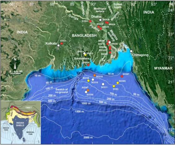


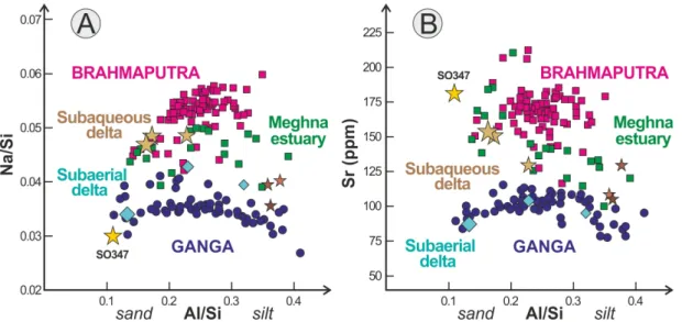
![Figure 7. Sediment in transit across the Bengal system ([5–7]). Note the predominance of Brahmaputra (magenta) over Ganga (cyan) supply to the Meghna estuary and subaqueous delta](https://thumb-eu.123doks.com/thumbv2/123doknet/14783797.597823/21.892.156.738.545.1020/figure-sediment-transit-bengal-predominance-brahmaputra-magenta-subaqueous.webp)
Documents relatifs
The turbidite sequences have higher Km values which indicates an increase in the concentration of magnetite and the Anhysteretic Remanent Magnetization (ARM) to magnetic
[ 56 ] In the Ganga River, the sediment concentration profiles are well explained by a Rouse type equation, which allows us to estimate the instantaneous sediment flux and average
[ 27 ] Apart from the most proximal sample from the western area (WP), which is discussed separately, bulk sediments from the Gulf of Lions show a fairly restricted range of Sr and
Tel est le message que le Conseil supérieur de l’éducation livre dans l’avis intitulé De la flexibilité pour un diplôme d’études secondaires de qualité au secteur des
Results obtained from the test by steps of time coincide with the re- sults of the test made with an almost permanent re- gime; the dimensions of the scour
We conclude that the Cabo Ortegal pyroxenites, dunites and chromitites resulted from melt-peridotite interaction initially involving picritic melts, which produced
Then we use the rating curves (in situ and satellite-derived) for computing Ganga and Brahmaputra discharges with Jason-2 satellite data, discuss the uncertainties and present
Using daily in situ river discharge data along with altimetry ‐ derived river heights, the present study aims to produce a monthly data set of altimetry ‐ derived Ganga ‐
