HAL Id: hal-00681378
https://hal-brgm.archives-ouvertes.fr/hal-00681378
Submitted on 21 Mar 2012
HAL is a multi-disciplinary open access
archive for the deposit and dissemination of
sci-entific research documents, whether they are
pub-lished or not. The documents may come from
teaching and research institutions in France or
abroad, or from public or private research centers.
L’archive ouverte pluridisciplinaire HAL, est
destinée au dépôt et à la diffusion de documents
scientifiques de niveau recherche, publiés ou non,
émanant des établissements d’enseignement et de
recherche français ou étrangers, des laboratoires
publics ou privés.
prediction in Guadeloupe and Martinique Modèle
empirique pour la prédiction rapide des intensités
macrosismiques en Guadeloupe et Martinique
François Beauducel, Sara Bazin, Mendy Bengoubou-Valerius, Marie-Paule
Bouin, Alexis Bosson, Christian Anténor-Habazac, Valérie Clouard,
Jean-Bernard de Chabalier
To cite this version:
François Beauducel, Sara Bazin, Mendy Bengoubou-Valerius, Marie-Paule Bouin, Alexis Bosson,
et al..
Empirical model for rapid macroseismic intensities prediction in Guadeloupe and
Mar-tinique Modèle empirique pour la prédiction rapide des intensités macrosismiques en Guadeloupe
et Martinique.
Comptes Rendus Géoscience, Elsevier Masson, 2011, 343 (11-12), pp.717-728.
Empirical model for rapid macroseismic intensities prediction
in Guadeloupe and Martinique
Modèle empirique pour la prédiction rapide des intensités macrosismiques
en Guadeloupe et Martinique
François Beauducela,∗, Sara Bazinb, Mendy Bengoubou-Valériusc, Marie-Paule Bouina, Alexis Bossona, Christian Anténor-Habazaca, Valérie Clouarda, Jean-Bernard de Chabaliera
aInstitut de physique du globe de Paris, Sorbonne Paris Cité,
Univ. Paris Diderot, UMR 7154 CNRS
bNorwegian Geotechnical Institute, Oslo cBRGM, Guadeloupe
Abstract
We describe a simple model for prediction of macroseismic intensities adapted to Guadeloupe and Martinique (Lesser Antilles), based on a combination of peak ground acceleration (PGA) predictive equation and a forward relation between acceleration and intensity. The PGA predictive equation is built from a 3-parameter functional form constrained by measurements from permanent
accelerometer stations, mostly associated with Les Saintes crustal earthquake (21/11/2004, Mw = 6.3) and its many aftershocks.
The forward intensity model is checked on a database of recent instrumental events of various origins with magnitudes 1.6 to 7.4, distances from 4 to 300 km, and observed intensities from I to VIII. Global sigma residual equals 0.8 in the MSK scale, suggesting a larger applicability range than the intermediate PGA predictive equation. The model is presently used by the French Lesser Antilles observatories to produce automatic reports for earthquakes potentially felt.
Résumé
Nous proposons un modèle simple de prédiction des intensités macrosismiques adapté à la Guadeloupe et à la Martinique (Petites Antilles) basé sur la combinaison d’une loi d’atténuation des accélérations horizontales maximales (PGA) et d’une relation directe entre accélération et intensité. Le modèle prédictif des PGA est contruit à partir d’une équation fonctionnelle à 3 paramètres contrainte par des données provenant de stations accélérométriques permanentes principalement associées au séisme des Saintes
(21/11/2004, Mw=6.3) et ses nombreuses répliques. Le modèle prédictif d’intensité est testé sur une base de données instrumentale
de séismes récents, de magnitudes 1.6 à 7.4, distances 4 à 300 km et intensités observées entre I et VIII. Le résidu RMS final est de 0.8 sur l’échelle MSK, ce qui suggère un plus large domaine d’applicabilité que le modèle intermédiaire des PGA. Le modèle est actuellement utilisé par les observatoires des Antilles françaises pour produire des communiqués semi-automatiques lors de séismes susceptibles d’être ressentis.
Keywords: earthquake, ground motion, macroseismic intensity, Lesser Antilles, peak ground acceleration
1. Introduction
The Lesser Antilles arc is a zone of convergence between the American plate and the Caribbean plate at a rate of about 2
cm/yr (Lopez et al.,2006). This movement is absorbed by the
subduction of the American plate below the Caribbean plate and deformation of the wedge of the upper plate on a 100-250 km-wide zone, producing an extended system of active crustal faults (Fig.1inset, (Feuillet et al.,2002)). It results in a high seismicity level (about 1000 detected events per year) located on the subduction interface and within the slab with hypocen-tral depths ranging from 10 km up to 220 km, and within the
∗. Corresponding author. Postal address : IPGP, 1 rue Jussieu, 75238 Paris Cedex 05, France. Phone : +33 1 83 95 75 28. Fax : +33 1 83 95 77 17
Email address: beauducel@ipgp.fr (François Beauducel)
deformed Caribbean plate with shallow crustal seismicity from 2 km up to 15-20 km in depth. Very shallow earthquakes occur-ring below/or very close to Guadeloupe archipelago islands can be felt sometimes with magnitude less than 2.0.
Since the french volcanological and seismological observa-tories (OVSG and OVSM) located in the Lesser Antilles are maintaining operational real-time seismic networks, they are responsible for detecting and informing local authorities and public of any felt earthquake occurrence and main event cha-racteristics : location (epicenter and depth), type (tectonic or volcanic), magnitude, and maximum reported intensity in Gua-deloupe and Martinique islands. Location and magnitude cal-culation are determined in a systematic way, using hand-picked phase arrivals and hypocenter inversion, and are available
62°W 61°W 15°N 16°N 17°N Nevis Antigua Montserrat Redonda Guadeloupe La Désirade Marie−Galante Les Saintes Dominica Martinique 1974.10.08 1976.03.10 1982.01.30 1985.03.16 2004.11.21 2005.02.14 2005.12.22 2007.11.29 NA SA CA ~2 cm/yr 65°W 60°W 10°N 15°N 20°N
Figure 1: Permanent network of digital accelerometers (TITAN AGECODA-GIS, see http ://www-rap.obs.ujf-grenoble.fr/) in Guadeloupe : soil (squares) and rock (triangles) site conditions (seeBengoubou-Valérius et al.(2008) for further details). Epicenters of some recent instrumental earthquakes are shown as black stars with dates (see text for details). Inset : Tectonic context of Lesser Antilles. CA = Caribbean plate, NA = North American plate, SA = South Ame-rican plate. Black thick line with triangles : accretionary prism frontal thrust. Black lines : crustal faults fromFeuillet et al.(2002). NA Euler vector ofLopez et al.(2006). Bathymetry data are 500 m contour lines (Smith and Sandwell,
1997).
Figure 1: Réseau permanent d’accéléromètres du Rap (numériseurs Titan Age-codagis, voir http ://www-rap.obs.ujf-grenoble.fr/) en Guadeloupe : conditions de site type sol (carrés) ou rocher (triangles) (voir (Bengoubou-Valérius et al.,
2008) pour plus de détails). Les épicentres de quelques séismes instrumentaux sont indiqués par des étoiles avec dates (voir texte). Encart : context tectonique des Petites Antilles. CA = plaque Caraïbe, NA = plaque Nord-Américaine, SA =plaque Sud-Américaine. Courbe noir avec triangles : fosse frontale du prisme d’accrétion. Lignes noires : système de failles crustales d’aprèsFeuillet et al.
(2002). Vecteur d’Euler pour la plaque NA d’aprèsLopez et al.(2006). Données de bathymetrie courbes de niveaux 500 m (Smith and Sandwell,1997).
thin few tens of minutes after an event, thanks to observatory permanent duty. Macroseismic intensities are determined later, as a result of detailed investigations in the field. However, in the case of strong felt earthquake, the first need of local authorities is to get practical information on event location and maximum possible effects in the living areas. If this information can be de-livered rapidly, it may be used to evaluate and focus assistance in the most concerned zones.
On November 21, 2004, the occurrence of Les Saintes event,
Mw = 6.3 and thousands of aftershocks in few days (IPGP,
2004; Bertil et al., 2004; Beauducel et al., 2005a; Courbou-lex et al.,2010;Bazin et al.,2010) offered an exceptional new strong-motion database thanks to the french permanent acce-lerometric network (Pequegnat et al.,2008) installed in 2002-2004. Combined with collected testimonies and official inten-sity estimations for largest events, this provided a unique op-portunity to establish a first local ground motion model adapted to the observatory needs.
In this paper, we present the modeling strategy, dataset, re-sults and applications of our empirical model. This work has
been previously described in an internal report (Beauducel
et al., 2005b), named B3 (from initials of the three original authors), and is presently used in Guadeloupe and Martinique seismological observatories to produce automatic reports. 2. Methodology
Our goal is to produce a predictive model of macroseismic intensities with a final uncertainty of about one intensity level, paying special attention to the maximum values that will be pu-blished after each earthquake. To be usable in an operative way, the model must be applicable to a wide range of magnitudes and hypocentral distances, and ideally independently from its tectonic context or depth.
Due to insular configuration of Lesser Antilles, most of epi-centers occur offshore : it concerns 95% of M ≥ 2.5 detected events (OVSG-IPGP database). Classical macroseismic inten-sity models cannot be used because they are based on maximum intensity at epicenter, I0(see for instancePasolini et al.(2008);
Sorensen et al. (2009)), a meaningless parameter for offshore events. Morever, we do not have sufficient intensity data to well constrain a predictive model for intensities. We have then pro-ceeded by combining, first, a ground motion predictive equation (GMPE) constrained by peak ground accelerations (PGA) local data, and second, applying a forward empirical relation between intensities and accelerations.
Many empirical relations to predict earthquake ground
mo-tions have been developed for engineering purposes (see
Abra-hamson and Shedlock (1997); Douglas(2003);Strasser et al.
(2009);Bommer et al.(2010) for a short review). Due to the ne-cessary high precision for these specific applications (like buil-ding damages study), models are developed using very selected datasets for specific applicability ranges of site conditions, ma-gnitude and depth. Moreover, none of them are valid for magni-tudes lower than 4.
Furthermore, in a recent studyDouglas et al.(2006), shows
are poorly estimated by commonly-used GMPE, having smaller and more variable amplitudes than expected.
In this work, we do not intend to produce a new GMPE for the engineering community ; we need a more general model with certainly higher uncertainty, but applicable over a wide range of earthquakes to be used in an operative way. In the fol-lowing we check results and residuals of our obtained PGA mo-del as an intermediate stage, but in order to validate the choices made to produce automatic reports, we emphasize tests of the final intensity model performance in terms of medians across full range of intensity and distance applicability and beyond. 3. Intermediate PGA predictive equation
3.1. Formulation and dataset
Due to the limited database and model purpose, we use one
of the simplest form of GMPEs with only 3 parameters (
Berge-Thierry et al.,2003) :
log(PGA) = aM + bR − log(R) + c (1)
where PGA is the horizontal acceleration peak (in g), M is the magnitude, R is the hypocentral distance (in km), and a, b, c are constant parameters.
This functional form implies many hypothesis. In particular, a radial distribution of ground motion around a point source, ne-glecting geological heterogeneities, tectonic origin, source ex-tension and radiation pattern.Fukushima(1996) also points out that a linear log(D)/M formulation is not verified for
magni-tudes ≥ 6.5 for which a M2 term should be necessary. This
concerns magnitudes out of our study range, but we will keep in mind that accelerations should be underestimated at long dis-tance for large magnitudes.
To inverse the three parameters, we use seismic data recorded at 14 strong-motion permanent stations in Guadeloupe (see Fig.
1), with mixed site conditions, rock and soil (details about the
seismic stations can be found in (Bengoubou-Valérius et al.,
2008)), in the period from November 21 to December 28, 2004.
The dataset includes about 400 earthquakes associated to 1430 triggers of 3-component acceleration waveforms. These events
correspond to Les Saintes main shock Mw=6.3 and mostly the
associated aftershocks, but also some regional events that we voluntarily kept in the database.
Locations and magnitudes come from the seismic catalog of Guadeloupe observatory (OVSG-IPGP). Magnitudes were computed using the classical formula of duration magnitude from Lee et al.(1975) for events Md ≤ 4.5 (Feuillard,1985;
Clément et al., 2000), and we imposed the moment magni-tude from worldwide networks for greater events. This allows to overcome the problem of duration magnitude saturation for magnitude greater than 4.5. The consistency of magnitude scale
(Mdversus Mw) has been checked byBengoubou-Valérius et al.
(2008).
For each event, a value of PGA is calculated as the maximum amplitude of horizontal acceleration signals, using the modulus of a complex vector defined by the two horizontal and ortho-gonal components x(t) and y(t). The PGA dataset is presented
1 2 3 4 5 6 7 0 200 400 600 Magnitude # of triggers 1 10 100 1000 0 200 400 600 Hypocentral Distance (km) # of triggers 0.0001 0.01 1 0 100 200 300 400 PGA (g) # of triggers
Figure 3: Histograms of the seismic dataset : number of trigger versus magni-tude, hypocentral distance (in km) and PGA value (in g).
Figure 3: Histogrammes des données : nombre de déclenchements en fonction de la magnitude, de la distance hypocentrale (en km) et du PGA (en g).
in Fig.2and3. Magnitudes range from 1.1 to 6.3, hypocentral
distances from 2 to 450 km, and PGA from 16 µg to 0.36 g. 3.2. Best model determination and residuals
To calculate the 3 parameters in Eq. (1), we minimized a
mis-fit function using the L2-norm. Due to the inhomogeneous
da-taset (magnitudes follow a power-law and there is more short-distances values), we applied a simple weighting function by multiplying the misfit by the magnitude and a power of the hy-pocentral distance. This gave more weight for large magnitudes and long distances.
The inversion scheme yields the following parameters : a = 0.61755, b = −0.0030746, and c = −3.3968. It produced an RMS residual on log (PGA) of 0.47 (a factor of 3 in PGA, see Fig.4). This value is higher than classical published GMPE re-sults (around 0.3, seeStrasser et al. (2009)), and it confirms
the observation ofDouglas et al.(2006) about abnormal data
variability in Lesser Antilles. But interestingly, this factor cor-responds to the average ratio between rock and soil conditions
in the observed PGA (Bengoubou-Valérius et al.,2008). This
might also reflects the wide range of magnitudes and distances in a too simple functional form. In order to follow some of
the key considerations used to develop GMPEs (Bommer et al.,
2010), we checked medians and sigmas of PGA residuals (Fig.
4) : it shows a very consistent distribution in the full magnitude range (from 2 to 6), while we observe a significant PGA unde-restimation (median around +0.5 so a factor 3 in amplitude) for D <15 km.
1 2 3 4 5 6 7 10−5 10−4 10−3 10−2 10−1 100 Magnitude PGA (g) 1 2 3 4 5 6 7 100 101 102 103 Magnitude Hypocentral Distance (km) 100 101 102 103 10−5 10−4 10−3 10−2 10−1 100 Hypocentral Distance (km) PGA (g) 100 102 104 2 4 6 10−5 100 Hypocentral Distance (km) Magnitude PGA (g)
Figure 2: Presentation of the seismic events dataset : 1430 triggers recorded by 14 permanent accelerometer stations from 2004.11.21 to 2004.12.28. Data are presented in 3-D view for different X-Y combinations of magnitudes, hypocentral distances (in km) and PGA values (in g). In the 3-D graph the view angle has been chosen to highlight the planar characteristic of the dataset.
Figure 2: Données sismiques utilisées : 1430 déclenchements enregistrés par 14 stations accélérométriques permanentes entre le 2004.11.21 et le 2004.12.28. Les données sont présentées pour différentes combinaisons X-Y de magnitudes, distances hypocentrales (en km) et valeurs de PGA (en g). Sur le graphe 3D l’angle de vue a été ajusté pour mettre en évidence l’aspect planaire du jeu de données.
1 2 3 4 5 6 7 −2 −1 0 1 2 Magnitude log(PGA obs ) − log(PGA calc ) 100 101 102 103 −2 −1 0 1 2 Hypocentral Distance (km)
Figure 4: PGA model residuals distribution : difference between observed and calculated log(PGA) versus magnitude and hypocentral distance (km). Horizontal segments with error bars stand for median values and associated standard deviations for each corresponding intervals. Global sigma of PGA residuals equals 0.47 (a factor of 3).
Figure 4: Résidus du modèle PGA : différence entre log(PGA) observé et calculé en fonction de la magnitude et de la distance hypocentrale. Les segments horizontaux avec barres d’erreur représentent les valeurs médianes et l’écart-type associé pour chaque intervalle. L’écart-type global des résidus est égal à 0.47 (un facteur 3).
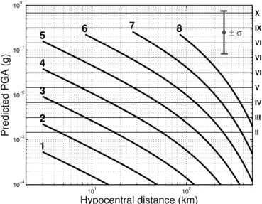
101 102 10−4 10−3 10−2 10−1 100 II III IV V VI VII VIII IX X 1 2 3 4 5 6 7 8 ± σ Predicted PGA (g) Hypocentral distance (km)
Figure 5: The B3prediction model : simulation of PGA (left Y-axis and log dot-ted horizontal grid) and MSK intensities (right Y-axis with roman numerals and solid thin horizontal lines) versus hypocentral distance (X-axis) and magnitude (thick solid lines and numbers). Uncertainty interval (σ = factor 3 in PGA) is indicated as gray vertical error bar. MSK is defined inMedvedev et al.(1967). Figure 5: Modèle B3: simulation des PGA (axe des ordonnées à gauche et grille logarithmique horizontale) et intensités MSK (axe des ordonnées de droite avec chiffres romains et lignes horizontales) en fonction de la distance hypocentrale (abscisses) et de la magnitude (lignes épaisses et chiffres en gras). L’intervalle d’incertitude (σ = facteur 3 sur le PGA) est indiqué par une barre d’erreur verticale grise. L’échelle MSK est définie dansMedvedev et al.(1967).
Eq. (1) with found parameters is represented as an abacus
in Fig.5showing calculated PGA as a function of hypocentral
distance (from 3 to 500 km) and magnitudes 1 to 8.
Note that we voluntarily limited the minimum hypocentral distance for each magnitude, as we do not take into account the near fault saturation term. It is reasonable to assume that this minimum hypocentral distance is greater than rupture size. Earthquake magnitude reflects the seismic moment which is proportional to the total displacement averaged over the fault
surface (Aki,1972; Kanamori,1977). Many authors propose
a simple formula to express the relationship between magni-tude and fault length or rupture area (Liebermann and Pomeroy,
1970;Mark,1977;Wyss,1979;Wells and Coppersmith,1994).
Here we use Wyss’s formula (Wyss,1979) :
M =log(A) + 4.15 (2)
where M is the magnitude and A the rupture surface. We decide to restrict the attenuation law of Eq. (1) to the domain R > L, where L ≈ A12 is an estimation of the fault characteristic size. 3.3. Examples of predicted and observed PGA
Fig.6shows representative events with observed PGA
com-pared to our model prediction. We do not limit examples to the events from the dataset which reflects the previous residual ana-lysis (Fig.4), but present events in the period 2004 to 2007 with various depths, in crustal or subduction context, and for which
sufficient triggers were available. As seen in Fig. 6, most of
PGA values are predicted within the model uncertainty. Me-dians of log(PGA) residuals are equal to +0.15, +0.28, +0.10,
+0.19, +0.24, and −0.01 for Fig. 6a to f events, respectively.
We denote, for these 6 particular examples, a light tendency for PGA underestimation, which seems independent from magni-tude. This is consistent with Fig.4residual analysis. The only significant PGA misfit appears for one soil condition station in the near field (≈ 15 km) for Les Saintes aftershocks (Fig.6b and c), that is systematically underestimated by a factor of about 10. We also compare these results with two published GMPE adapted to shallow crustal events :Sadigh et al.(1997) and Am-braseys(1995).Sadigh et al.(1997) model is very similar to our
PGA model for magnitudes ≥ 5.0 (Fig.6a, c and f) but has poor
fitting for lower magnitudes (Fig.6b, d and e) with a
systema-tic overestimation.Ambraseys(1995) model has a global poor
fitting with overestimation of PGA, particularly for M < 5.0. 4. Macroseismic intensities
4.1. Formulation
Although we know that spectral frequency content of ground acceleration and peak velocity have important implications on the building damages, establishing a direct relation between a single PGA value and macroseismic intensity has proved its
ef-ficiency in many cases (Murphy and O’Brien,1977;
Chiarut-tini and Siro,1981;Margottini et al.,1992;Wald et al.,1999).
For the Lesser Antilles, we follow the suggestion byFeuillard
(1985) who studied the historical and instrumental seismicity
using the simple empirical relation ofGutenberg and Richter
(1942) :
I =3 log(PGA) + 3/2 (3)
where I is the mean intensity (MSK scale ), PGA is maximum acceleration (in cm.s−2 ≈mg). Combining equations (1), (2)
and (3) made the final empirical model formulation (hereafter
called B3prediction) : (
I = 1.85265M − 0.0092238R − 3 log(R) + 0.3096
R > 10M−4.152 (4)
Note that following MSK scale, intensity must be an integer value. In this paper, we decided arbitrarily to round I to the nearest and smallest integer (e.g., I = 6.0 to 6.9 correspond to intensity of VI).
The resulting model for intensities is presented as right Y-axis in Fig.5. Following Eq. (3), the 0.47 uncertainty on our predicted log(PGA), would imply an uncertainty on I of ±1.4, on which we should add the uncertainty of Eq. (3) itself, which is unknown.
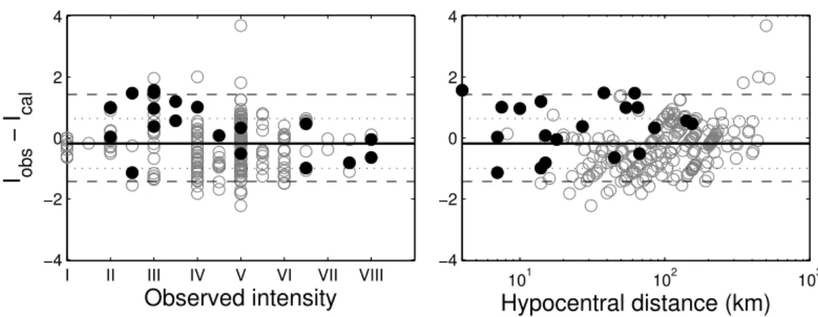
4.2. Intensity model residuals
We test our model on a database of 20 recent earthquakes for which we have intensity reports (a total of 254 observations) as well as instrumental magnitudes and hypocenter locations. Events are from various origins with magnitudes 1.6 to 7.4, dis-tances from 4 to 500 km, and observed intensities from I to
101 102 10−4 10−3 10−2 10−1 100 a) 2004−11−21 11:41 TU, M = 6.3, 10 km depth PGA (g) Hypocentral distance (km) 101 102 10−4 10−3 10−2 10−1 100 b) 2004−12−19 05:12 TU, M = 3.2, 10 km depth PGA (g) Hypocentral distance (km) 101 102 10−4 10−3 10−2 10−1 100 c) 2005−02−14 18:05 TU, M = 5.8, 9 km depth PGA (g) Hypocentral distance (km) 101 102 10−4 10−3 10−2 10−1 100 d) 2006−03−31 02:47 TU, M = 3.4, 27 km depth PGA (g) Hypocentral distance (km) 101 102 10−4 10−3 10−2 10−1 100 e) 2006−07−20 02:07 TU, M = 3.3, 96 km depth PGA (g) Hypocentral distance (km) 101 102 10−4 10−3 10−2 10−1 100 f) 2007−02−27 09:42 TU, M = 5.0, 21 km depth PGA (g) Hypocentral distance (km)
Figure 6: PGA prediction (solid thick curve) and uncertainty (solid thin curves) for various magnitudes and depths. The recorded PGA values are presented in squares in the case of soil site condition and in triangles for rock site condition. Are also shown other attenuation laws :Sadigh et al.(1997) (dashed curve) and
Ambraseys(1995) (dotted curve). Inset maps show epicenter location for each event (star). a) Les Saintes main shock, b) and c) are aftershocks. d) is a shallow subduction event located east of Guadeloupe. e) is a deep subduction event located north of Guadeloupe. f ) is a shallow crustal event located south of Antigua. Figure 6: Prédiction des PGA (courbe épaisse) et incertitudes (courbes fines) pour différentes magnitudes et profondeurs. Les PGA observés sont présentés par des carrés pour les conditions de site type sol, et par des triangles pour les conditions de site type rocher. Sont aussi indiquées d’autres lois d’atténuation :Sadigh et al.
(1997) (courbe tiretée) etAmbraseys(1995) (courbe pointillées). Les cartes en encart indiquent la position de l’épicentre pour chaque événement (étoile). a) Choc principal du séisme des Saintes, b) et c) sont des répliques. d) Séisme superficiel sur le plan de subduction à l’est de la Guadeloupe. e) Séisme profond de subduction au nord de la Guadeloupe. f ) Séisme crustal superficiel au sud d’Antigua.
I II III IV V VI VII VIII −4 −2 0 2 4
Observed intensity
I
obs− I
cal 101 102 103 −4 −2 0 2 4Hypocentral distance (km)
Figure 7: Intensity model residuals distribution for 20 earthquakes (254 macroseismic observations) : difference between observed and calculated intensities versus observed intensity and hypocentral distance (km). Solid black circles indicate the maximum observed intensity for each event. Thick black line = median value (−0.2). Dotted lines = standard deviation (±0.85). Dashed lines = PGA standard deviation equivalent (±1.4).
Figure 7: Distribution des résidus du modèle prédictif des intensités pour 20 séismes (254 observations macrosismiques) : différence entre intensité observée et calculée en fonction des intensités observées et de la distance hypocentrale (km). Les disques noirs indiquent l’intensité observée maximum pour chaque événement. Ligne épaisse = valeur médiane (−0.2). Lignes pointillées = écart-type (±0.85). Lignes tiretées = écart-type PGA équivalent (±1.4).
VIII. This wide panel of event characteristics allows to check our model applicability.
We present in Fig.7the intensity residuals versus observed
intensity and hypocentral distance. Global standard deviation equal 0.8, with a near zero median value. Residuals are also well distributed over the intensity and distance ranges. Since this da-tabase is not statistically sufficient, we will keep uncertainty on intensities deduced from the PGA residuals, i.e., σ = 1.4 cor-responding to 68% confidence interval. We also checked that maximum observed intensity for each event is strictly below this probability level (see Fig.7solid circles).
4.3. Examples of simulated and observed intensities
In Fig. 8, we detail eight examples of the most significant
events with observed and predicted intensities (see epicenters in Fig.1).
Fig. 8a shows the October 10, 1974 “Antigua” earthquake
(Tomblin and Aspinall,1975;McCann et al.,1982), Ms=7.4,
a shallow 30 km-depth with normal-fault mechanism, Msfrom
NEIC USGS, location and MSK intensities fromMcCann et al.
(1982). Maximum intensities and distance of observations vary
from VIII at 45 km in Antigua to II at 400 km in Virgin Islands. All the observations (9 sites) are within the B3prediction uncer-tainty limits. Median of intensity residuals equals −0.6, sigma is 0.5. This is an unexpected positive result since the model is
ex-trapolated for magnitudes larger than Les saintes (Mw =6.3) ;
so this magnitude 7.4 is formally out of our interval of validity. Note also that near-field intensities (at 45 km) seem correctly fitted by the model while this hypocentral distance is very close to our limit defined by Eq. (2), which gives L = 42 km.
Fig.8b shows the March 10, 1976 earthquake, a magnitude
Mb =5.9, 56 km-depth on subduction interface north of
Gua-deloupe (Mb from USGS-NEIC, location and MSK intensities
fromFeuillard(1985)). Maximum intensities and distances of observations vary from V in Le Moule (Guadeloupe) at 85-km, to II in Martinique at 150 km distance. Most of the 22 observed
intensities are underestimated (median of residuals is +0.4) but still within one sigma uncertainty (RMS equals 0.5).
Fig.8c shows the January 30, 1982 earthquake, a magnitude
Mw =6.0, 63 km-depth on subduction interface north of
Gua-deloupe (Mwand location from Global CMT Project, MSK
in-tensities fromFeuillard(1985)). Maximum intensities and dis-tances of observations vary from V in various urban districts of Guadeloupe and Antigua at 90 km distance, to II in Barbuda (130 km). Most of the 34 observed intensities are within the B3 uncertainty limits, with a zero median and RMS on intensity residuals equal to 0.7.
Fig. 8d shows the March 16, 1985 “Redonda” earthquake
(Girardin et al.,1991;Feuillet et al.,2010), a magnitude Mw=
6.3, 10 km-depth normal-fault (Mw and location from Global
CMT Project, MSK intensities fromFeuillard(1985)).
Maxi-mum intensities and distances of observations vary from VI at 30 km in Montserrat to II at 300 km in Martinique. We ad-ded a supposed intensity of VII-VIII (light gray dashed rec-tangle) because important cliff collapses have been observed in the Redonda island, at 10 km-distance from epicenter. All the 23 observed intensities are within the B3uncertainty limits (RMS = 0.7) with zero median. Note a very local amplification effect that occurred in the region of Pointe-à-Pitre (Guadeloupe) with an intensity of V to VI at 120 km from the hypocenter.
Fig. 8e shows the November 21, 2004 Les Saintes main
shock earthquake of magnitude Mw = 6.3, Mw from Global
CMT Project, location fromBazin et al.(2010), EMS98
inten-sities (see definition inGrunthal et al.(1998)) from an official
survey by the BCSF (Cara et al.,2005). Maximum intensities
and distances of observations vary from VIII at 20 km in Les Saintes to IV at 140 km in Martinique, and correspond to detai-led studies carried on by BCSF in 33 different urban districts. All the 29 observed intensities are within the B3uncertainty li-mits (RMS = 0.6 , median = −0.9).
Fig.8f shows the largest Les Saintes aftershock, on February
Terre-de-10 20 30 40 50 100 200 300 400 500 II III IV V VI VII VIII IX X
a)
MSK scale Hypocentral distance (km) October 08, 1974, M = 7.4 10 20 30 40 50 100 200 300 400 500 II III IV V VI VII VIII IX Xb)
MSK scale Hypocentral distance (km) March 10, 1976, M = 5.9 10 20 30 40 50 100 200 300 400 500 II III IV V VI VII VIII IX Xc)
MSK scale Hypocentral distance (km) January 30, 1982, M = 6.0 10 20 30 40 50 100 200 300 400 500 II III IV V VI VII VIII IX Xd)
MSK scale Hypocentral distance (km) March 16, 1985, M = 6.3 10 20 30 40 50 100 200 300 400 500 II III IV V VI VII VIII IX Xe)
MSK scale Hypocentral distance (km) November 21, 2004, M = 6.3 10 20 30 40 50 100 200 300 400 500 II III IV V VI VII VIII IX Xf)
MSK scale Hypocentral distance (km) February 14, 2005, M = 5.8 10 20 30 40 50 100 200 300 400 500 II III IV V VI VII VIII IX Xg)
MSK scale Hypocentral distance (km) December 22, 2005, M = 4.2 10 20 30 40 50 100 200 300 400 500 II III IV V VI VII VIII IX Xh)
MSK scale Hypocentral distance (km) November 29, 2007, M = 7.4Figure 8: Examples of B3predicted intensities for 8 instrumental earthquakes : observed macroseismic intensities (MSK) are presented versus hypocentral distance
(km). Gray thick curve stands for the predicted intensity for given magnitude, dashed curves indicate uncertainties, solid rectangles represent intensity observations. a), d), e), f ) g) are shallow crustal earthquakes, b) and c) are ≈ 60 km-depth subduction slab interface, h) is an intermediate depth intraslab subduction.
Figure 8: Exemples des intensités prédites B3pour 8 séismes instrumentaux : intensités macrosismiques observées (MSK) en fonction de la distance hypocentrale
(km). La courbe épaisse grise réprésente l’intensité prédite pour une magnitude donnée, les courbes tiretées indiquent l’incertitude, les rectangles pleins représentent les intensités observées. a), d), e), f ) g) sont des séismes crustaux, b) et c) sont des séismes à l’interface de subduction à ≈ 60 km de profondeur, h) est un séisme de subduction intraslab de profondeur intermédiaire.
Haut (Mwand location from Global CMT Project, MSK inten-sities from OVSG-IPGP). Maximum inteninten-sities and distances of observations vary from VII at 14 km in Les Saintes to IV at 74 km in Anse-Bertrand (Guadeloupe). All the 25 observed
intensities are within the B3 uncertainty limits (RMS = 0.3 ,
median = −1.0) with a global light overestimation.
Fig.8g shows one of the numerous Les Saintes aftershocks,
on December 22, 2005 of magnitude Md=4.2, located north of
Terre-de-Bas (Md, location and MSK intensities from
OVSG-IPGP, unpublished). Maximum intensities and distances of ob-servations vary from V at 15 km in Basse-Terre to II at 58 km in Saint-François (Guadeloupe). All the 7 observed intensities are
within the B3uncertainty limits (RMS = 0.6 , median = −0.3).
Fig. 8h shows the November 29, 2007 Martinique
intermediate-depth (152 km) intraslab earthquake of magnitude Mw=7.4, Mwand location fromBouin et al.(2010) and Global CMT Project, with EMS98 intensities from an official survey by the BCSF (Schlupp et al.,2008). Maximum intensities and dis-tances of observations vary from VII at 150 km in Martinique to II at 400 km in St-Barthelemy, and correspond to detailed studies carried on by BCSF in 70 different urban districts in Guadeloupe and Martinique, plus other islands reports. Most of the 74 observed intensities are within the B3 uncertainty limits (RMS = 0.83 , median = −0.1), but we note three underestima-ted intensities at long distances : V in Saint-Vincent (250 km) and Trinidad (500 km), and IV in Anguilla (443 km). This may be due to local site amplifications because of low frequency content of the seismic waves.
These eight examples confirm that B3 model seems able to
predict average intensities within a global residual of σ = 1.4 degree in the MSK scale, for events of magnitudes up to 7.4 in Lesser Antilles context with various hypocentral distances. This value corresponds to 68% of confidence interval and gives a convincing maximum possible intensity even when local site effects are observed.
5. Automatic intensity report
These good results and the apparent robustness of the B3
mo-del made us confident for the release of semi-automatic theore-tical intensity report at the Guadeloupe and Martinique observa-tories. For each located event, maximum intensity is computed for all towns of Lesser Antilles islands. If at least one location reaches an intensity of II, it means that the event has been po-tentially felt and an automatic report is produced, waiting for seismologist validation.
This simulation allows 1) to confirm that inhabitants may have (or not) felt the event when intensity interval varies from II to III in a town ; and 2) to publish immediately and blindly (wi-thout any testimonies) the information of a possible felt earth-quake when the predicted maximum intensity reaches IV, which means 68% of confidence for an intensity between I-II and IV.
The report (see an example in Fig. 9) includes a synthetic
text resuming the date, location and type of event, the maxi-mum intensity prediction value and corresponding town name and distance. To better take into account potential site effects
and increase the precision of the result, the average prediction is given together with the upper limit value (I + σ = I + 1.4) for potential site effects, and MSK intensities are indicated in half-unit values, i.e., I = 6.0 to 6.4 is “VI”, and I = 6.5 to 6.9 is “VI-VII”. The exhaustive list of urban districts for which theoretical intensity reaches at least II is given. Note that it in-cludes all islands in the Lesser Antilles, while our model has been mainly checked with Guadeloupe and Martinique intensi-ties. This may constitutes a future extension of our study.
The report also includes a location map that presents the is-lands and towns, earthquake epicenter and theoretical isoseist curves using a shaded color map. A detailed table legend ex-plains the MSK scale and corresponding name, color, PGA in-terval, potential damages and human perception.
6. Discussion and conclusions
We propose a simple empirical model for macroseismic in-tensities prediction for observatory operational purpose. The model is based on intermediate PGA model that has been ad-justed using a shallow crustal normal-fault sequence of events. The functional form is only 3-parameters dependent which im-plies many assumptions and simplifications, but makes it also extremely robust with an uncertainty higher than usual GMPE (a factor of 3). This can be explained also by the fact that we do not select specific site conditions in the database, mixing rock and soil stations. The obtained PGA model has strong poten-tial limits and may not be very useful for engineering purposes, but it exhibits a better fit than previous existing GMPE for Les-ser Antilles. Its application domain should be limited to crustal events, magnitude range up to 6.3, and distance range up to 100-200 km.
The deduced intensity model is tested on a wider range of magnitudes, distances and source types of earthquakes. We sug-gest that the B3model is able to correctly predict intensities wi-thin ±1.4 (1σ), for magnitudes up to 7.4 and hypocentral dis-tance up to 300 km. At longer disdis-tances, we observe a clear un-derestimation of intensities. A major result of our work is that the final equation seems to exhibit a larger applicability range than intermediate PGA predictive equation. In particular, grea-ter magnitudes and other types of earthquakes such as those lo-cated in the subduction slab are well modeled within the given uncertainties.
This model is currently used to produce automatic reports in Guadeloupe (since January 2005) and Martinique (since Sep-tember 2008) observatories in order to anticipate potentially felt events immediately after the location and magnitude cal-culation. On a total amount of about 10, 000 located events in Guadeloupe, a third has been potentially felt (minimal intensity of II) and has produced an automatic report. Following the ob-servatory convention, only 200 reports were effectively sent as a public communiqué, when the minimum theoretical intensity reached IV or in case of lower intensity (II or III) when imme-diate testimonies were received from inhabitants.
During more than 5 years of continuous seismic monitoring
SIMULATION
Rapport préliminaire de séisme concernant la Guadeloupe et Îles du Nord
Observatoire Volcanologique et Sismologique de Guadeloupe − IPGP Le Houëlmont − 97113 Gourbeyre − Guadeloupe (FWI)
Tél: +590 (0)590 99 11 33 − Fax: +590 (0)590 99 11 34 − infos@ovsg.univ−ag.fr − www.ipgp.fr
Gourbeyre, le 21 novembre 2004 10:00 locales Magnitude 6.3, 15.76°N, 61.50°W, profondeur 10 km
dimanche 21 novembre 2004 11:41:08 TU
Un séisme fort (magnitude 6.3 sur l’Échelle de Richter) a été enregistré le dimanche 21 novembre 2004 à 07:41 (heure locale) et identifié d’origine Tectonique. L’épicentre a été localisé à 14 km au sud de
Terre−de−Haut, à 10 km de profondeur (soit une distance hypocentrale d’environ 18 km). Ce séisme a pu
générer, dans les zones concernées les plus proches, une accélération moyenne du sol de 160 mg (*), correspondant à une intensité macrosismique de VIII (dégâts importants potentiels). Suivant le type de sols, les intensités peuvent cependant avoir atteint localement l’intensité IX−X (destructions potentielles).
64°00’W 63°30’W 63°00’W 62°30’W 62°00’W 61°30’W 61°00’W 60°30’W 60°00’W 14°30’N 15°00’N 15°30’N 16°00’N 16°30’N 17°00’N 17°30’N 18°00’N II II II II II II III III III III III III III IV IV IV IV IV IV IV IV V V V V V VI VI VI VII VII VIII Intensités probables moyennes
(et maximales) :
Terre−de−Haut : VIII (IX−X)
Terre−de−Bas : VII−VIII (IX)
Grand−Bourg : VII (VIII−IX)
Trois−Rivières : VII (VIII−IX)
Saint−Louis : VII (VIII−IX)
Vieux−Fort : VII (VIII−IX)
Capesterre−B/E : VII (VIII−IX)
Gourbeyre : VII (VIII)
Basse−Terre : VII (VIII)
Capesterre−de−M/G : VII (VIII)
Saint−Claude : VI−VII (VIII)
Baillif : VI−VII (VIII)
Goyave : VI−VII (VIII)
Vieux−Habitants : VI−VII (VIII)
Petit−Bourg : VI (VII−VIII) Le Gosier : VI (VII−VIII) Bouillante : VI (VII−VIII) Sainte−Anne : VI (VII−VIII) Pointe−à−Pitre : VI (VII−VIII) Baie−Mahault : VI (VII−VIII)
Les Abymes : VI (VII−VIII)
Le Lamentin : VI (VII−VIII)
Saint−François : VI (VII−VIII)
Pointe−Noire : VI (VII−VIII)
Morne−à−l’eau : V−VI (VII)
Le Moule : V−VI (VII)
Sainte−Rose : V−VI (VII)
Deshaies : V−VI (VII)
Petit Canal : V−VI (VII)
Port−Louis : V−VI (VII)
La Désirade : V−VI (VII)
Anse−Bertrand : V−VI (VI−VII)
Saint−Barthélemy : II (III−IV)
Saint−Martin : I−II (III)
Hors la Guadeloupe et Îles du Nord Dominica : VII−VIII (IX)
Martinique : IV−V (VI)
Montserrat : IV (V−VI)
Antigua : III−IV (V)
Nevis : III (IV−V)
Saint Lucia : III (IV−V)
Barbuda : III (IV)
Saint Kitts : III (IV)
Sint Eustatius : II (III−IV)
Saba : II (III−IV)
Saint Vincent : I−II (III)
Anguilla : I−II (II−III)
Barbados : I (II)
WEBOBS (c) OVSG−IPGP 2011 − Loi d’atténuation B−Cube [Beauducel et al., 2004−2009]
Terre−de−Haut Terre−de−Bas 10 km VIII VIII VIII
Perception Humaine non ressenti très faible faible légère modérée forte très forte sévère violente extrême Dégâts Potentiels aucun aucun aucun aucun très légers légers modérés importants destructions généralisés Accélérations (mg) < 1.5 1.5 − 3.2 3.2 − 6.8 6.8 − 15 15 − 32 32 − 68 68 − 150 150 − 320 320 − 680 > 680
Intensités EMS98 I II III IV V VI VII VIII IX X+ (*) mg = "milli gé" est une unité d’accélération correspondant au millième de la pesanteur terrestre
La ligne pointillée délimite la zone où le séisme a pu être potentiellement ressenti.
Figure 9: Example of observatory communiqué published in case of potential felt event : here an a posteriori simulation of Les Saintes main shock (data from OVSG-IPGP). The B3model is used to estimate the probable macroseismic intensities. Are indicated the exhaustive list of towns or neighborough islands where the
event could be felt, with maximum intensity in case of site amplification (afterBeauducel et al.(2005b)). Title : « Preliminary report of earthquake in Guadeloupe and Northern Islands »
Main text : « A strong earthquake (magnitude 6.3 on the Richter Scale) was recorded on Sunday, November 21, 2004 at 07:41 (local time) and identified with tectonic origin. The epicenter was located 14 km south of Terre-de-Haut, 10 km-depth (hypocentral distance of about 18 km). This earthquake may have generated, in the closest areas from epicenter, an average ground acceleration of 160 mg (*), corresponding to macroseismic intensity of VIII (severe potential damages). However, depending on the type of soil, the intensities may have reached locally an intensity of IX-X (potential destructions). »
Towns list : « Average (and maximum) probable intensities : »
Table : « Human perception / Potential damages / Accelerations (mg) / MSK Intensity » Note : « (*) “mg” is a unit of acceleration equal to one thousandth of Earth’s gravity »
Figure 9: Exemple de communiqué publié par l’observatoire en cas de séisme ressenti : ici une simulation a posteriori du séisme des Saintes (données OVSG-IPGP). Le modèle B3est utilisé pour estimer les intensités moyennes probables. Est mentionnée la liste exhaustive des communes ou îles voisines ayant pu ressentir le
controlled by observatory team : comparisons between obser-vations and predicted intensities exhibit an average uncertainty less than ±1 unit in the MSK scale.
The reports were also used for seismic hazards awareness and education of the public and local authorities. Particularly, explaining the fundamental difference between magnitude and intensity of an earthquake, the MSK scale, the uncertainty of prediction due to the law’s empirical aspect and simplicity, and the potential site condition effects, thus earthquake-resistant construction advices.
Acknowledgments
FB thanks Pascal Bernard and Nathalie Feuillet for use-ful discussions, Victor Huerfano and Fabrice Cotton for very constructive comments that helped us to greatly improve the initial manuscript. Acceleration data come from the French na-tional strong motion permanent network Réseau
Accéléromé-trique Permanent (RAP), available at
http://www-rap.obs.ujf-grenoble.fr/. Stations have been installed and maintained from 2002 to 2004 thanks to the effort of technicians from the
ob-servatory of Guadeloupe (OVSG-IPGP) : Alberto Tarchini†,
Christian Lambert, Laurent Mercier, Alejandro Gonzalez, and Thierry Kitou. Authors warmly thank Guadeloupe inhabitants for their collaboration in collecting testimonies. This is an IPGP contribution #3222.
Références
Abrahamson, N., Shedlock, K., 1997. Overview (of modern attenuation rela-tionships). Seismol. Res. Lett. 68, 9–23.
Aki, K., 1972. Earthquake mechanism. Tectonophysics 13, 423–446. Ambraseys, N., 1995. The prediction of earthquake peak ground acceleration
in europe. Earthquake Engin. & Struct. Dyn. 24, 467–490.
Bazin, S., Feuillet, N., Duclos, C., Crawford, W., Nercessian, A., Bengoubou-Valérius, M., Beauducel, F., Singh, S., 2010. The 2004-2005 les saintes (french west indies) seismic aftershock sequence observed with ocean bot-tom seismometers. Tectonophysics 489, 91–103.
Beauducel, F., Anténor-Habazac, C., Bazin, S., de Chabalier, J., Nercessian, A., Feuillet, N., Jacques, E., Bertil, D., Boudon, G., Le Friant, A., Tapponnier, P., Hirn, A., Lépine, J., Bernard, P., Komorowski, J., King, G., team, O., 2005a. The Mw 6.3 earthquake of Les Saintes (Guadeloupe) on Novem-ber 21, 2004, in : European Seismological Commission Annual Workshop, IAVCEI.
Beauducel, F., Bazin, S., Bengoubou-Valérius, M., 2005b. Loi d’atténuation B-Cube pour l’évaluation rapide des intensités sismiques probables dans l’Ar-chipel de Guadeloupe. Internal Report pp 16. Institut de Physique du Globe de Paris.
Bengoubou-Valérius, M., Bazin, S., Bertil, D., Beauducel, F., Bosson, A., 2008. CDSA : A New Seismological Data Center for the French Lesser Antilles. Seismol. Res. Lett. 79, 90.
Berge-Thierry, C., Cotton, F., Scotti, O., Griot-Pommera, D., Fukushima, Y., 2003. New empirical response spectral attenuation laws for moderate euro-pean earthquakes. J. Earthquake Eng. 7, 193–222.
Bertil, D., Bazin, S., Mallarino, D., Beauducel, F., 2004. Séisme des Saintes : rapport de synthèse. Technical Report. Centre de Données Sismologiques des Antilles (CDSA), BRGM/IPGP/UAG.
Bommer, J., Douglas, J., Scherbaum, F., Cotton, F., Bungum, H., Fah, D., 2010. On the selection of ground-motion prediction equations for seismic hazard analysis. Seismol. Res. Lett. 81, 783.
Bouin, M.P., Bouchon, M., Coutant, O., Bazin, S., Latchman, J., 2010. Source parameters of the Mw 7.4 Martinique intermediate-depth earthquake (Lee-ward islands) of November 29, 2007 : A slab-pull event with horizontal fault
plane, in : EGU General Assembly 2010, held 2-7 May, 2010 in Vienna, Austria, p. 5555.
Cara, M., Bertil, D., Feuillet, N., Jacques, E., Tapponnier, P., Guéguen, P., Bengoubou-Valérius, M., Sira, C., Lebrun, B., Beauducel, F., 2005. Séisme des Saintes (Guadeloupe) du 21 novembre 2004, note préliminaire. Techni-cal Report. Bureau Central de Sismologie Française.
Chiaruttini, C., Siro, L., 1981. The correlation of peak ground horizontal accele-ration with magnitude, distance, and seismic intensity for Friuli and Ancona, Italy, and the Alpide belt. Bull. Seism. Soc. Am. 71, 1993.
Clément, C., Bernard, P., Viodé, J., Anténor-Habazac, C., Lépine, J., Beauducel, F., 2000. Compilation et validation du catalogue de sismicité des observa-toires IPGP des Antilles. Technical Report. Ministère de l’Aménagement du Territoire et de l’Environnement, Institut de Physique du Globe de Paris. Courboulex, F., Converset, J., Balestra, J., Delouis, B., 2010. Ground-motion
simulations of the 2004 mw 6.4 les saintes, guadeloupe, earthquake using ten smaller events. Bull. Seism. Soc. Am. 100, 116.
Douglas, J., 2003. Earthquake ground motion estimation using strong-motion records : a review of equations for the estimation of peak ground acceleration and response spectral ordinates. Earth Sci. Rev. 61, 43–104.
Douglas, J., Bertil, D., Roullé, A., Dominique, P., Jousset, P., 2006. A prelimi-nary investigation of strong-motion data from the french antilles. J. Seismol. 10, 271–299.
Feuillard, M., 1985. Macrosismicité de la Guadeloupe et de la Martinique. Ph.D. thesis. Institut de Physique du Globe de Paris.
Feuillet, N., Leclerc, F., Tapponnier, P., Beauducel, F., Boudon, G., Le Friant, A., Deplus, C., Lebrun, J., Nercessian, A., Saurel, J., et al., 2010. Active faulting induced by slip partitioning in Montserrat and link with volcanic activity : New insights from the 2009 GWADASEIS marine cruise data. Geophys. Res. Lett. 37.
Feuillet, N., Manighetti, I., Tapponnier, P., Jacques, E., 2002. Arc parallel ex-tension and localization of volcanic complexes in Guadeloupe, Lesser An-tilles. J. Geophys. Res. 107, 2331.
Fukushima, Y., 1996. Scaling relations for strong ground motion prediction models with m2 terms. Bull. Seism. Soc. Am. 86, 329.
Girardin, N., Feuillard, M., Viodé, J., 1991. Réseau régional sismique de l’arc des Petites Antilles ; sismicité superficielle (1981-1988). Bull. Soc. Geol. Fr. 162, 1003.
Grunthal, G., Musson, R., Schwarz, J., Stucchi, M., 1998. European Macroseis-mic Scale 1998 (EMS-98). Cahiers du Centre Européen de Géodynamique et de Séismologie 15.
Gutenberg, B., Richter, C., 1942. Earthquake magnitude, intensity, energy, and acceleration. Bull. Seism. Soc. Am. 32, 163–191.
IPGP, 2004. Bilan mensuel de l’activité volcanique de la Soufrière de Gua-deloupe et de la sismicité régionale. Public reports of OVSG-IPGP ISSN 1622-4523. Institut de Physique du Globe de Paris.
Kanamori, H., 1977. The energy release in great earthquakes. J. Geophys. Res. 82, 2981–2987.
Lee, W., Lahr, J., N.C.E.R., 1975. HYPO71 (revised) : a computer program for determining hypocenter, magnitude, and first motion pattern of local ear-thquakes. US Dept. of the Interior, Geological Survey, National Center for Earthquake Research.
Liebermann, R., Pomeroy, P., 1970. Source dimensions of small earthquakes as determined from the size of the aftershock zone. Bull. Seism. Soc. Am. 60, 879.
Lopez, A., Stein, S., Dixon, T., Sella, G., Calais, E., Jansma, P., Weber, J., LaFe-mina, P., 2006. Is there a northern Lesser Antilles forearc block ? Geophys. Res. Lett. 33.
Margottini, C., Molin, D., Serva, L., 1992. Intensity versus ground motion : a new approach using italian data. Eng. Geol. 33, 45–58.
Mark, R., 1977. Application of linear statistical models of earthquake ma-gnitude versus fault length in estimating maximum expectable earthquakes. Geology 5, 464.
McCann, W., Dewey, J., Murphy, A., Harding, S., 1982. A large normal-fault earthquake in the overriding wedge of the Lesser Antilles subduction zone : The earthquake of 8 October 1974. Bull. Seism. Soc. Am. 72, 2267. Medvedev, S., Sponheuer, W., Karnik, V., 1967. Seismic intensity scale version
1964. Inst. Geody. Publ. 48.
Murphy, J., O’Brien, l., 1977. The correlation of peak ground acceleration amplitude with seismic intensity and other physical parameters. Bull. Seism. Soc. Am. 67, 877.
attenuation of seismic intensity in Italy, part I : Theoretical and empirical backgrounds. Bull. Seism. Soc. Am. 98, 682.
Pequegnat, C., Gueguen, P., Hatzfeld, D., Langlais, M., 2008. The French ac-celerometric network (RAP) and national data centre (RAP-NDC). Seismol. Res. Lett. 79, 79.
Sadigh, K., Chang, C., Egan, J., Makdisi, F., Youngs, R., 1997. Attenuation re-lationships for shallow crustal earthquakes based on california strong motion data. Seismol. Res. Lett. 68, 180.
Schlupp, A., Sira, C., Cara, M., Bazin, S., Michel, C., Régnier, J., Beauval, C., Feuillet, N., De Chabalier, J., Barras, A., et al., 2008. Séisme de Marti-nique du 29 novembre 2007. Synthèse sismologique et étude macrosismique BCSF2008-R1, Bureau Central Sismologique Français 266.
Smith, W., Sandwell, D., 1997. Global sea floor topography from satellite alti-metry and ship depth soundings. Science 277, 1956.
Sorensen, M., Stromeyer, D., Grunthal, G., 2009. Attenuation of Macroseismic Intensity : A New Relation for the Marmara Sea Region, Northwest Turkey. Bull. Seism. Soc. Am. 99, 538.
Strasser, F., Abrahamson, N., Bommer, J., 2009. Sigma : Issues, insights, and challenges. Seismol. Res. Lett. 80, 40–56.
Tomblin, J., Aspinall, W., 1975. Reconnaissance report of the antigua, west indies, earthquake of october 8, 1974. Bull. Seism. Soc. Am. 65, 1553. Wald, D., Quitoriano, V., Heaton, T., Kanamori, H., 1999. Relationships
bet-ween peak ground acceleration, peak ground velocity, and modified Mercalli intensity in California. Earthquake Spectra 15, 557.
Wells, D., Coppersmith, K., 1994. New empirical relationships among magni-tude, rupture length, rupture width, rupture area, and surface displacement. Bulletin of the Seismological Society of America 84, 974–1002.
Wyss, M., 1979. Estimating maximum expectable magnitude of earthquakes from fault dimensions. Geology 7, 336.