HAL Id: insu-01718405
https://hal-insu.archives-ouvertes.fr/insu-01718405
Submitted on 27 Feb 2018
HAL is a multi-disciplinary open access
archive for the deposit and dissemination of sci-entific research documents, whether they are pub-lished or not. The documents may come from teaching and research institutions in France or abroad, or from public or private research centers.
L’archive ouverte pluridisciplinaire HAL, est destinée au dépôt et à la diffusion de documents scientifiques de niveau recherche, publiés ou non, émanant des établissements d’enseignement et de recherche français ou étrangers, des laboratoires publics ou privés.
Outcrops: N’Kapa Formation of the South-Eastern Edge
of Douala Sub-Basin (Cameroon)
Paul Kwetche, Marie Joseph Ntamak-Nida, Adrien Lamire Djomeni Nitcheu,
Jacques Etame, François Mvondo Owono, Cecile Olive Mbesse, Joseph
Bertrand Iboum Kissaaka, Gilbert Ngon Ngon, Sylvie Bourquin, Paul Bilong
To cite this version:
Paul Kwetche, Marie Joseph Ntamak-Nida, Adrien Lamire Djomeni Nitcheu, Jacques Etame, François Mvondo Owono, et al.. Facies Analysis and Sequence Stratigraphy of Missole Outcrops: N’Kapa Formation of the South-Eastern Edge of Douala Sub-Basin (Cameroon). Earth Sciences Research, Canadian Center of Science and Education, 2018, 7 (1), pp.35-54. �10.5539/esr.v7n1p35�. �insu-01718405�
Published by Canadian Center of Science and Education
Facies Analysis and Sequence Stratigraphy of Missole Outcrops:
N’Kapa Formation of the South-Eastern Edge of Douala Sub-Basin
(Cameroon)
Paul Gustave Fowe Kwetche1, Marie Joseph Ntamak-Nida1, Adrien Lamire Djomeni Nitcheu1, Jacques Etame1,
François Mvondo Owono1, Cecile Olive Mbesse1, Joseph Bertrand Iboum Kissaaka1, Gilbert Ngon Ngon1,
Sylvie Bourquin2 & Paul Bilong3
1 Université de Douala, Département des Sciences de la Terre, BP 24 157, Douala, Cameroun
2 Géosciences Rennes, UMR 6118 CNRS/INSU, OSUR, Université de Rennes 1, Campus de Beaulieu, 35042
Rennes Cedex, France
3 Université de Yaoundé I, Département des Sciences de la Terre, BP 812, Yaoundé, Cameroun
Correspondence: Paul Gustave Fowe Kwetche, Université de Douala, Département des Sciences de la Terre, BP 24 157, Douala, Cameroun. Tel: 237-6753-41357. E-mail: paologustav@yahoo.fr
Received: August 19, 2017 Accepted: August 30, 2017 Online Published: October 21, 2017 doi:10.5539/esr.v7n1p35 URL: https://doi.org/10.5539/esr.v7n1p35
Abstract
Missole facies description and sequence stratigraphy analysis allow a new proposal of depositional environments of the Douala sub-basin eastern part. The sediments of Missole outcrops (N’kapa Formation) correspond to fluvial/tidal channel to shallow shelf deposits with in some place embayment deposits within a warm and semi-arid climate. Integrated sedimentologic, palynologic and mineralogical data document a comprehensive sequence stratigraphy of this part of the Douala sub-basin. Five facies associations occur: (1) facies association I is characterized by Floodplain deposits; (2) facies association II is Fluvial to mouth bar deposits; (3) facies association III characterise Shallow Shelf deposits; (4) facies association IV represents Distal bay or Lacustrine déposits; and (5) Facies association V is made of Fluvial channel deposits. Six depositional sequences were identified. These sequences are composed of four progradational sequences and two retrogradational sequences containing a fluvial channel portion represented by lag deposits at the base of retrogradational sequences. These deposits represent the outset of the relative sea level rise period. In the study area, the N’kapa Formation is composed of non-marine/coastal aggradational deposits representing the early stage of the regressive period. The occurrence of the estuarine/bay deposits with paleosols development is interpreted as evidence of climate change with significant relative base level fluctuation. The study of key minerals associated to sequence stratigraphy as well as palynology demonstrated that sequence architecture has been controlled mostly by climate evolution and outcrops are dated Paleocene – early Eocene.
Keywords: Facies, sequence stratigraphy, climate, N’kapa, Missole, paleocene-early eocene 1. Introduction
The studies of Cameroon sedimentary basins started early in the 20th century, by explorers and German mining researchers and continues, from 1940, with research about basins exploration (e.g. Solger, 1904; Riedel, 1932; Andreef, 1947; Dartevelle and Brebion, 1956; Dartevelle and Freneix, 1957; Belmonte, 1966; Dumort, 1968; Reyment, 1980). These studies required stratigraphic and palaeogeographic data thanks to facies and biostratigraphic analyses.
In the framework of basin analysis, the best studies through subsurface data (seismic, well logs, cuttings and cores) are made by oil companies and then remain confidential. Each oil company uses therefore its own stratigraphic chart of the explored basin. Basic problems of stratigraphic correlations between well logs had shown that an integrated biostratigraphic study was required to establish an update framework for those basins. These are good for a better understanding of low frequency cycles but not for genetic units or parasequences as defined by Van Wagoner et al. (1990). These sequences which are referred by Bourquin et al. (2010) as not older than 1 million of year are mostly well studied on outcrops exposures. Because of the scarcity of outcrops along the Douala sub basin due to the dense rain forest and weathering, best exposures can only be studied in railways-
and road-cuts and stream channels.
Missole deposits outcropping along the “Nationale 3” road-cuts towards the south-eastern edge of the Douala sub basin are known as dated Paleocene - Eocene according to geological map (Fig. 1) of Dumort (1968). However none detailed sequence stratigraphic framework has yet been done on these deposits. This paper aims, first to bring out a better understanding in the evolution of depositional environments by doing a detailed sedimentological study of various facies within this area, secondly to study the architecture of Missole outcrops by defining and discussing of the evolution of different sequences through time and space and finally to discuss of the relative age of these sediments thanks to palynological first results.
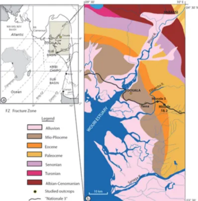
Figure 1. (a) Location of the Douala sub-basin in Cameroon (West Africa) between the main fractures of the Cameroon margin (compiled from Meyers, Rosendahl, Groschel-Becker & Austin (1996), Rosendahl and Groschel-Becker (1999), Daily et al. (2002), Wilson, Turner & Westbrook (2003)). (b) Lithostratigraphy of the
Douala sub-basin (compiled from Dumort (1968) and Champetier & Reyre (1957)) and location of Missole studied outcrops
2. Geological Settings and Previous Research
The Douala sub-basin is located between 3°45’N and 5°N (Fig. 1). It covers an area of approximately 12 000 km2 of which 5 500 km2 are onshore. The landscape is extremely rugged, and covered with dense rainforest: this limits the accessible and usable exposure to the gorges and tributaries of the main streams and to the existing road and railway sections.
The proximity of the Benue Trough added to the proximity of the Cameroon Volcanic Line complicate the tectonic history of the Douala sub-basin and then their development probably had a significant impact on sedimentation patterns (Lawrence, Munday & Bray, 2002; Manga, 2008; Djomeni et al., 2011). The tectono-stratigraphic history of the Douala sub-basin includes several episodes of tectonic activity, which can be grouped in two great stages: (1) in the first stage (top Early Cretaceous-upper Oligocene), basin development and sedimentation is related primarily to rift associated tectonics. This first stage can be divided in two phases of burial (late Aptian –Turonian and Senonian-Eocene) and two erosive phases (Senonian unconformity and mid-Eocene to base Miocene); (2) in the second stage (upper Oligocene – Recent), basin development and sedimentation were related primarily to the development of the Cameroon Volcanic Line, particularly the development of the Oligocene to Recent volcanoes (ECL, 2001; Lawrence et al., 2002).
Figure 2. Tectono-lithostratigraphy of the Douala sub-basin (compiled from Nguene, Tamfu, Loule & Ngassa (1992), Lawrence et al. (2002) and Brownfield and Charpentier (2006))
The stratigraphy of the Douala sub-basin presents seven formations named from the base to top: Mundeck, Logbadjeck, Logbaba, N’kapa, Souellaba, Matanda and Wouri (Fig. 2). The focus of the study is the outcrops of Missole (road section, Fig. 1) at the Center-East of Douala sub-basin. The N’kapa Fm. is considered as Paleocene – Eocene from Dumort (1968). Previous studies conducted in these outcrops by Bachirou et al. (2014) and Ngon Ngon et al (2016) provided facies analysis, depositional environments and geochemical charcteristics of Missole outcrops. However, no sequence stratigraphic study has been published for these outcrops since the building of the "Nationale 3" road in 1984. These outcrops of SW-NE direction are about 7 km long for the two cut-sections of the road. But the better exposures are about 200 m long (Figs. 1, 3). According to Belmonte (1966), the N’kapa Fm comprised marine facies northward and continental facies southward. For Dumort (1968), Regnoult (1986) and some unpublished reports, the N’kapa Fm is widely developed across the Douala sub-basin and comprises mainly variably silty mudstones with minor interbeds of very fine to medium grained sandstones, locally argillaceous, sandstones, interpreted to represent muddy shelf sedimentation. The literature sources according to Salard-Cheboldaeff (1981) indicate that the Late Cretaceous and Paleocene were characterised by cooler conditions, with moderately low to high amounts of rainfall, resulting in the development of savannah-woodland vegetation types. This was followed by the establishment of increasingly hot, high rainfall
conditions, and hence the development of lowland rain forest, during the Eocene. These conditions have persisted up to the present day.
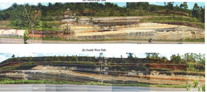
Figure 3. Missole outcrops: a- NE road-sections cut; b – SW road sections cut
3. Data Sets and Methods
In the central-eastern part of the Douala sub-basin, the Paleocene-Eocene successions were analysed at Missole on two outcrops of SW and NE direction (Fig. 3), where a dip of 10°NNW is observed. This study allowed to realise three mains sedimentological sections (named Missole 1, 2 and 3, respectively M1, M2 and M3, Figs. 1 & 3). The section M1 is located NE side of the road while M2 section is located SW (Fig. 3a & b). M3 section is another road-cut section located 4 km from M2 towards WNW.
Ten samples (E1 to E10) from clay, sand, conglomerate facies and iron rich fraction horizons were collected on section M1 and processed for mineralogical contents. Mineralogical studies were conducted by X-ray diffraction (XRD) at IMPMC (Institute of Mineralogy and Physics of Condensed Milieu of Paris, France). The samples were previously air dried and crushed to a size < 2µm and analysis were applied (CoKα : λ=1.790260Å, 40KV, 35mA) within an angular domain of 2-70° (2θ) with step of 0.02° (oriented powder) and 2° (random powder). The value of each peak characterizes a precise mineral. Semi-quantitative estimations were carried out following Chakavorty and Ghosh (1991), in order to evaluate the mineral proportion in each sample. Semi-quantitative determinations are based on the peak intensities and areas of selected mineral peaks (Holtzapffel, 1985).
A semi-quantitative estimation of clay minerals was done from peak area using the formula: % mineral=100 × [I mineral/ΣI all minerals in the sample]
Facies descriptions are followed by the depositional processes following Postma (1990) and Miall (1978, 1996) and their associations were used to interpret vertical evolution of depositional environments. Sequence stratigraphy interpretations followed the methods of Posamentier and Vail (1988), Van Wagoner et al., (1990). Tectonic features such as soft sediments deformations, faults and fractures were also investigated. Facies described are based solely on available Missole outcrops and may not reflect characteristics of all over the N’kapa Fm known by subsurface descriptions. XRD data have been used to complete the previous informations and integrated to determine depositional environments and ultimately to sediment supply and changes in relative sea level. Only main minerals with great importance will be discussed in this study.
Some samples taken from the fine facies (clays) were collected for palynological analysis. These samples were previously washed, dried and crushed for chemical treatment. The chemical treatment consisted of a first attack with HCl (30%) to remove the carbonates. This attack was followed, after rinsing with distilled water, of an attack with HF (40%) in order to dissolve the mineral material. A second hot HCl treatment was then applied, in order to separate the palynomorphs from the rest of the organic matter. After filtration on a 12 μm sieve, an oxidation with HNO 3 (60%) was carried out for 2 minutes, enabling the palynomorph wall to be exposed. The material was mounted on slides for microscopic observation. The sporomorphic identifications were made in
comparison with the data found in some articles from Africa and from West and South America.
4. Facies Analysis
Three detailed sedimentological sections allow to describe facies and depositional environments of the study area. Twenty facies were identified, described and interpreted in terms of depositional processes based on lithology, sedimentary structures, pedogenetic features and other contains. Facies descriptions are summarized in Table 1.
Table 1. Lithofacies of Missole outcrops. The facies code are modified after Miall (1978, 1996) and Postma (1990), and interpreted after Lowe (1982), Miall (1978, 1996), Nemec and Steel (1984) and. Postma (1990)
Facies Code Facies name Lithology Sedimentary structures Depositional process Floodplain and Lacustrine deposits
Fmb (Fig. 5d)
Bioturbated clay and silt
Clay and silt, dark greenish grey to greenish dark, some gravels of quartz, rare fragments of coal (lignite), abundant pyrite (5 – 10%)
Massive, bioturbated U-burrows (diplocraterion?) mostly vertical cylindrical (around 1 to 1.5 cm of tube diameter and 2 - 3 cm thick).
Deposition from suspension in confined environment. Fmp (Fig. 5c) Massive silt and clay
Silt and clay, yellowish grey to light olive grey, very indurated, isolated pile of pyrite (1cm φ), locally well preserved plants leaves remains, small fragments of coal (10%), siderite
Massive Deposition from suspension
Fm Clayey silt facies with some gravels
Silt and clay with scattered subangular to subrounded gravels of quartz, some moulds of gastropods and bivalves
Massive, bioturbated Deposition from suspension with few waning flood
Fluvial / Mouth bar deposits Srb (Fig. 4g) Heterolithic
sandstone and siltstone, bioturbation
Fine to medium-grained sandstone and siltstone, dark grey to light grey, moderately sorted, rare fragments of coal
Some ripple cross lamination, bioturbated
Current ripples, lower part of the lower flow regime (Miall, 1978) reworking by biological activity in subaqueous environment Sr (Fig. 4f) Fine-grained sand, silt and clay with coal
Fine-to medium-grained sandstone, subangular to subrounded gravel of quartz, moderately sorted, abundant fragments of coal; mould or fossils of bivalves
Massive, small ripples, faintly lamination underlying by discontinuous fragment of coal, sharp basal and top boundaries, bioturbated
Tractive current and current ripples (Miall, 1978)
Slb (Fig. 4h) Laminated fine sand and silt, bioturbation
Laminated fine- to medium sand interbedded with dark grey clay or silt, moderately sorted, rare fragment of coal
Horizontal lamination, bioturbated
Subaqueous overbank, alternating with suspension deposits
Fb (Fig. 5f) dark to greenish grey Clay and silt bioturbated
Clay and silt, dark to greenish grey, some scattered granules and pebbles of quartz, with moulds of bivalves (5%)
Thin laminated and abundant horizontal bioturbations (70%) (chondrites?), (1 mm of diameter and 2-3 cm of width). Deposition from suspension with few waning flood
Shoreface deposits
Sub (Fig. 4c) Coarse sand with gravels and some scattered coal
Coarse sand with scattered gravels of quartz (<1.5 cm), subrounded to subangular, poorly to moderately sorted, some fragments of coal and fossils (moulds of bivalves and gastropods)
Ungraded to weakly normally graded, bioturbated, sharp basal boundary.
Subaqueous high density turbidite current (Lowe, 1982; Mulder and Alexander, 2001)
with gravels and coaly layer
(<1.5 cm), subrounded to subangular, poorly to moderately sorted, rare fragments of fossils (moulds of bivalves and gastropods), discontinuous coal layer
erosional basal boundary 1978) or hyper concentrated density flow (Lowe, 1982; Mulder and Alexander, 2001)
Sgb Clayey fine sand with coal
Clayey fine sand, medium light grey, gravel of quartz decrease upward, scattered moulds of bivalves and gastropods, fragments of coal
Normally graded, bioturbated
Subaqueous high density turbidite current (Lowe, 1982; Mulder and Alexander, 2001)
Fml (Fig. 5e)
Heterolithic silt and clay facies
Heterolithic facies composed of silt and clay, interbedded with mm to cm beds or lenses of silty-sandstones, with scattered subangular to subrounded gravels of quartz, some moulds of gastropods and bivalves, abundant fragments of coal
Massive or laminated, bioturbated
Deposition from suspension alternating with waning flood
Mouth bar and Shallow Shelf deposits Sb (Fig. 5a) Medium- to
coarse-grained sandstone with ophiomorpha
Medium- to coarse-grained, white, yellow to reddish mottled sandstone moderately to well sorted
No sedimentary structure due to intense bioturbation (ophiomorpha?) and dewatering structures. Some level are indurated and more ferruginised. Reworking of sand deposits by biological activity in subaqueous environment Shb (Fig. 5b) Medium- to coarse-grained with Herringbone stratifications and bioturbation
Medium- to coarse- grained, white to reddish mottled sandstone moderately to well sorted.
Herringbone stratifications, bioturbated
Tidal current; Flood and ebb currents.
Ssig (Fig. 5a) Medium- to coarse-grained sandstone graded with sigmoid and bioturbation
Medium- to coarse-grained, white to reddish mottled sandstones, moderately to well sorted, graded
Low angle mm lamination faintly dipping evolving laterally to sigmoidal forest (5 cm to 20 cm), bioturbated (ophiomorpha?)
Tractive currents
Distal bay
Sur (Fig. 4d) Clayey pebbly
sand with P2 features
Brown to greenish grey, clay to sandstone, with gravel of quartz, moulds of gastropods and bivalves, fragments of coal, scattered particles of pyrite associated with P2 features
Ungraded, sharp basal boundary.
Low energy deposits with possible high-velocity currents in a confined environment rich swamp vegetation
Su (Fig. 4b) Coarse sand with gravels and coaly layer
Coarse sand with scattered gravels of quartz (<1.5 cm), subrounded to subangular, poorly to moderately sorted, rare fragments of fossils (moulds of bivalves and gastropods), discontinuous coal layer
Ungraded, sharp or erosional basal boundary
Lag deposits (Miall, 1978) or hyperconcentrated density flow (Lowe, 1982; Mulder and Alexander, 2001)
Ss (Fig. 4e) Fine- to medium- sandstones with deformed stratifications
Fine- to coarse-grained, yellowish to reddish, sandstones with some granules and small pebbles
Structures with synforms shapes, very indurated and ferruginous with soft sediment deformation structures (Djomeni et al., 2011)
Tractive current, upper part of the lower flow regime (Miall, 1978).
with coal coal (> 5%) structures on the top boundary
suspension
P2 Massive ferruginous rhizoconcretions (3 - 7 cm of diameter and 10 - 50 cm of length) of vertical roots connected to a network of horizontal root traces
Wet soil, swampy setting, high water table (Hasiotis & Bourke, 2006; Hasiotis, Platt, Hembree & Everhart., 2007) Fluvial channels Gcm (Fig. 4a) Clast-supported conglomerate
Clast-supported conglomerate with quartz gravels of various sizes, subangular to subrounded, very poorly sorted
Massive, sharp basal boundary
Tractive currents
P1 (Fig. 5g) Clast-supported conglomerate composed of ferruginous breccias Weathering and pedogenesis of existing facies, Debris flow
Missole 1 and 2 Sections
M1 and M2 sections are described together since, the two sections are facing one to another and facies are generally the same. The extension of these outcrops are about 200m of width and 15m and 13 m of height respectively for M1 and M2 sections. Five facies associations were identified along Missole 1 and 2 sedimentologic profiles.
Floodplain and Fluvial Deposits (Fmp, Fmb, Srb, Sr, Slb)
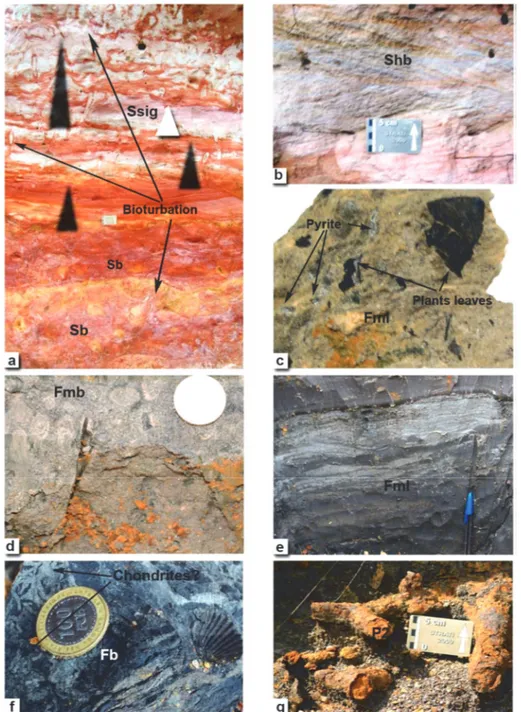
The first association located at the base of Missole M1 and M2 sections (Figs. 6a, b) is constituted of facies Fmp, Fmb, Srb, Sr, Slb (Table 1). This association begins with Fmb facies (Fig. 5d) which is a dark greenish grey layer of clay and silt with moulds of bivalves, U-burrows bioturbations attributed to diplocraterion as well as rare fragments of coal and some gravels of quartz. Burrows are mostly vertical with cylindrical shape (around 1 to 1.5 cm of tube diameter and 2 - 3 cm thick). This facies is top by a very indurated yellowish grey to light olive grey of silt and clay (Fmp facies, 20cm in thickness, Fig. 5c) characterised by coal fragments, plant leaves remains, diagenetic features as siderite and pyrite minerals. These fine deposits evolve vertically to bioturbated rippled sandstones deposits (facies Srb, Figs. 4g, 6a, b). Srb facies appears at different levels of the M1 section with thickness of 50cm to 1.15m and 1.75m of thickness at M2. Srb facies is interbedded with laminated fine- to medium sand interbedded with dark grey clay and silt (facies Slb, 27cm of thickness; Figs. 4h, 6b) and fine to medium-grained sandstones of facies Sr (Figs. 4f, 6a, b, 12cm to 1m of thickness), which are characteristic of subaqueous overbanks (Table 1).
Clayey and silty sediments (facies Fmp and Fmb) are interpreted as suspension deposits, while presence of pyrite provides evidence of anoxic conditions. Trace fossils (gastropods, bivalves) and presence of siderite indicate stressed, brackish water with fresh water input (Potsma, 1990; Buatois, Mángano & Timothy , 1999). Srb and Sr facies with ripple cross laminations are characteristic of the lower part of the lower flow regime (Miall, 1978) deposited by tractive currents. Slb facies are interpreted as subaqueous flood while bioturbations of facies Srb and Slb indicate an environment suitable for subaqueous live (Buatois, Mángano, Genise & Taylor, 1998). This association is interpreted as a floodplain deposits (Facies Fmb, Fmp) evolving upward to a fluvial environment represented by facies Srb, Sr and Slb.
Shoreface Deposits (Su, Sub, Sgb, Fml)
The subaqueous deposits previously described are overlain by a facies association describing a fining upward sequence (Fig. 6a, b) showing at the base, ungraded to weakly graded coarse-grain sandstone typical of lag deposits. The lower part of this facies (facies Sub, Fig. 4c, Table 1) is bioturbated with scattered subrounded to subangular gravels of quartz (<1.5 cm). The basal boundary of this facies is slightly erosive while its thickness range between 15cm at M1 and 85cm at M2. The upper part (facies Su, Fig. 4b, Table 1) of this facies, denied of bioturbations appears over Sub facies with a thickness of 1.5m and at the middle part of the M1 section. This association evolves upward to a bioturbated graded clayey sandstones (facies Sgb, 1.75 to 2m in thickness) followed by heterolithic silt and clay (facies Fml, about 50cm to 2.50m in thickness) with abundant fragments of coal and subangular to subrounded gravels of quartz.
The coarse-grain sandstone of facies Su, Sub and Sgb (Fig. 4c, Table 1) are interpreted as high-density turbidite current deposits (Lowe, 1982; Mulder and Alexander, 2001) overlain by waning flood facies (Fml, Fig. 5e) of subaqueous environment (Bourquin et al., 2010). The fining upward sequence is typical of sand sheet supply within subaqueous environment with marine influence as attest by fossils traces of bivalves. Bioturbations characterise the reworking of the sands by biological activity within subaqueous environment. This association is
interpreted as shoreface deposits.
Figure 4. Conglomeratic and sandstone lithofacies of Missole; a) Conglomeratic sandstones of Gcm facies, b,c,d) Ungraded sandtones sometimes biotubated (Sub) and with fine ripples (Sur), e) sandstnoes with deformed stratifications, f, g) sandstones with ripples structures sometimes bioturbated (Srb), laminated and bioturbated
sandstones Shoreface Deposits (Su, Sub, Sgb, Fml)
The subaqueous deposits previously described are overlain by a facies association describing a fining upward sequence (Fig. 6a, b) showing at the base, ungraded to weakly graded coarse-grain sandstone typical of lag deposits. The lower part of this facies (facies Sub, Fig. 4c, Table 1) is bioturbated with scattered subrounded to subangular gravels of quartz (<1.5 cm). The basal boundary of this facies is slightly erosive while its thickness range between 15cm at M1 and 85cm at M2. The upper part (facies Su, Fig. 4b, Table 1) of this facies, denied of bioturbations appears over Sub facies with a thickness of 1.5m and at the middle part of the M1 section. This
association evolves upward to a bioturbated graded clayey sandstones (facies Sgb, 1.75 to 2m in thickness) followed by heterolithic silt and clay (facies Fml, about 50cm to 2.50m in thickness) with abundant fragments of coal and subangular to subrounded gravels of quartz.
Figure 5. Sandstones and fine lithofacies of Missole; a) Bioturbated sands sometimes conteining sigmoid structures, b) sandstones with herringbones structures, c) massive silt and clay facies with pyrites and plants leaves remains, d) Bioturbated sikt and clay facies with U-burrows (Diplocraterions?), e) heterolithic silt and clay facies, f) Bioturbated clayey facies with mould of bivalves and chondrites traces, g) Ferruginous root traces
(Rhizoconcretions)
The coarse-grain sandstone of facies Su, Sub and Sgb (Fig. 4c, Table 1) are interpreted as high-density turbidite current deposits (Lowe, 1982; Mulder and Alexander, 2001) overlain by waning flood facies (Fml, Fig. 5e) of subaqueous environment (Bourquin et al., 2010). The fining upward sequence is typical of sand sheet supply within subaqueous environment with marine influence as attest by fossils traces of bivalves. Bioturbations characterise the reworking of the sands by biological activity within subaqueous environment. This association is interpreted as shoreface deposits.
Distal Bay / Restricted Estuarine (Su, Sur, P2, Ff, Fml, Ss)
The third association lies on the most marine deposits of facies association 2 and is constituted of facies Su, Sub, P2, Fml (Figs. 6a, b). The association starts with ungraded sandstones with erosional basal boundary (facies Su, Fig. 4b, 15cm in thickness) evolving vertically to heterolithic silt and clay facies (facies Fml, Fig. 5e, about 50cm in thickness). This facies is overlain at M1 section, by four levels of palaeosols development (rhizoconcretions, P2, Table 1; Fig 5g) within clayey pebbles sandstones (facies Sur, Figs. 4d, 6a). Rhizoconcretions are constituted of vertical ferruginised root traces connected to a network of horizontal root traces (3 – 7cm of diameter and 10 – 50cm of length). These levels also contain a few amount of pyrite, moulds of bivalves and evolve vertically to clay and silt (facies Ff, fig. 4a, 1.65 m in thickness) with small pieces of coal. Its lateral evolution towards M2 section is constituted of two levels of Fml facies interbedded with Su facies (50 cm in thickness) without rhizoconcretions. The top of these facies consist in fine to medium sandstones yellowish to reddish (Facies Ss, Table 1, Figs. 4e, 6a, b) of 50 to 60 cm thick. This facies is characterised by intensive deformation structures considered by Djomeni et al. (2011) as soft sediment deformation structures and some granules and pebbles of quartz. The upper boundary of this facies is characterised by flames structures. This facies association attests of subaqueous environment with some waning flood (facies Fml), sediment supply (facies Sur) or episode of emersion are characterised by ferruginised root traces (Hasiotis & Bouke, 2006; Hasiotis et al., 2007) while pyrite indicates anoxic conditions. These facies evolve vertically to suspension deposits (facies Ff) and further to tractive current deposits of the upper part of the lower flow regime (Miall, 1978) characterised by Ss facies. According to Djomeni et al. (2011), soft sediment deformation structures observed resulted from the contrast of density between the upper conglomeratic facies and these sandstones slightly after deposition. This environment is interpreted as a bay or a restricted estuarine environment.
Fluvial channels (Facies Gcm, P1)
This association is formed by clast-supported conglomerates (facies Gcm, Fig. 4a, 60cm in thickness) with subangular quartz gravels of various sizes, very poorly sorted. Gcm facies is separated from the clast-supported conglomerate facies of ferruginous breccias (P1, Table 1, 1.50m in thickness) by a sharp boundary.
The Gcm facies is interpreted as channel fills deposited by tractive currents (Postma, 1990) while ferruginous breccias found at the top of the association are typical of pedogenesis and weathering of existing facies and interpreted as deposited as debris flows. This association constituted of proximal facies are inferred to a fluvial channel environment.
Missole 3 section
M3 section is a SW section situated 5 km from M2 section towards the Dibamba River. Three associations can be observed on this section.
Lacustrine environment (Facies Fm, Sr)
The base of the section is composed of clayey silts (facies Fm, Fig. 6c, Table 1) of 3.30m in thickness, interbedded with fine to medium grained sandtones levels (Facies Sr, Fig. 6c, 20cm in thickness) with bioturbations
Fm facies is typical of subaqueous environment with few waning flood. This association is characteristic of lacustrine deposits.
Shallow Shelf (Facies Sb, Ssig, Shb)
This association is constituted of medium to coarse-grained bioturbated sandstone (facies Sb, Fig. 5a) overlain by sandstones deposits with sigmoid (facies Ssig, Fig. 5a; Table 1) and herringbones structures (facies Shb, Fig. 6b; Table 1) always bioturbated by ophiomorpha. This facies is 1m thick and bounded by erosional surfaces. The upper part of this facies is constituted of interbbeded layers of Ssig (35cm to 1m) and Sb facies (60 to 80cm), bounded each by erosional surfaces.
The sandstone facies Sb located at the base of this association is interpreted as reworked sediments of subaqueous environment. Medium to coarse-grain sandstones with sigmoïds (Facies Ssig) is related to tractive currents and considered by Marshall (2000) as deposited in distal mouth bar environment. Sandstones with herringbones structures (facies Shb; Table 1; Fig. 6b) are characteristic of ebb and flow currents. These characteristics associated to relative abundance of ophiomorpha indicating a shallow marine environment led to attribute these deposits to a shallow shelf environment.
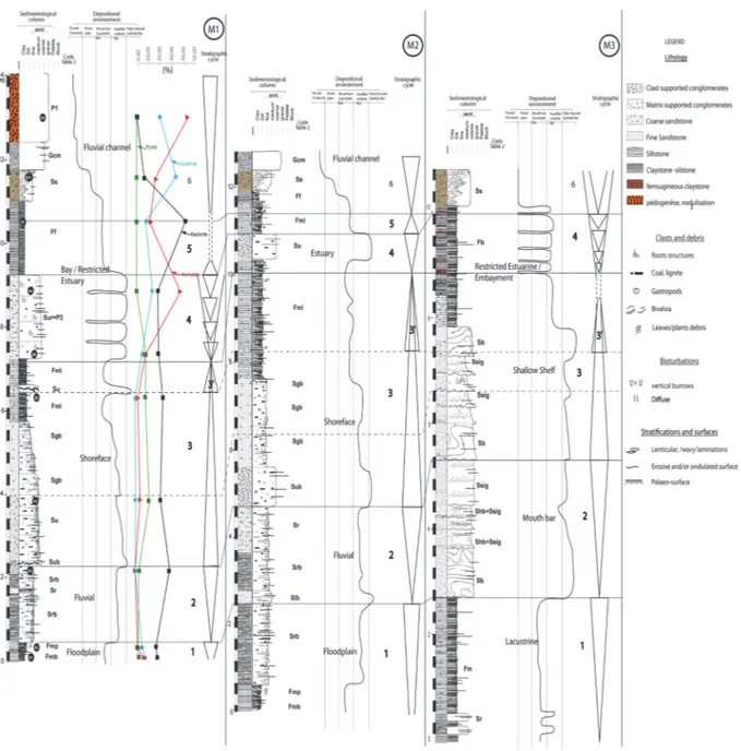
Figure 6. Detailed logs of Missole’s sedimentary succession (M1, M2, and M3), sequence stratigraphy analysis and inferred paleoenvironments
Lacustrine environment (Facies Fb, Ss)
The upper part of the section is made of clay and silt (facies Fb, Fig. 5f, 1.75m thick) with granules and pebbles, chondrites and nerites traces as well as gastropods and bivalves. Fb facies shows different levels of thin ferruginous layers, slightly eroded characterising periods of emersion.This facies is overlain by intensively deformed Ss facies (Fig. 4a, 80cm thick) resulting from tractive currents.
Clay and silt facies are typical of suspension deposits with few waning flood while chondrites and nerites traces indicate oxygen-starved and low energy conditions (Parcha & Singh., 2005). The association of facies Fb and Ss is interpreted as restricted estuarine/embayment.
The three sections of Missole (M1, M2 and M3) have revealed different type of environments, moving from continental to marine. The lateral and vertical evolution of these environments indicate base level fluctuations characterising dry and wet periods. These periods were registered within sediments as rhizoconcretions indicating a permanent water level period followed by arid period characterised by ferruginisation. During these different times different minerals were formed. Their relative abundance would thus indicate climate evolution and ultimately base level rises and falls.
4.1 Mineralogy
The XRD results (Fig. 7; see, Fig. 6a for samples location) indicate that the assemblage is diversified. Quartz, muscovite, kaolinite, pyrite, chlorite, gibbsite, goethite, smectite, hematite, siderite are the main minerals present in almost all the samples but differ in crystallinity and proportions. Kaolinite is the dominant clay mineral. But its percentage decreases progressively and become significantly low at the top of the section, excepted in sample E7 (facies Ff, Figs. 4a, 6a), which shows the highest value (> 40%). Smectite is the clay mineral well represented after kaolinite, especially from the base to the middle of section (Figs. 6a). Hematite amount increases toward the top of the section with highest values in iron rich fractions such as rhizoconcretions (Figs. 5g & 6a), and ferruginous breccias (sample E9, Fig. 6a), which are more represented at the top of the section M1. Siderite is abundant at the base of the section (> 30%). In sample E6, hematite proportion reaches 20% but remains under 10% in the others layers (Fig. 8b). Goethite is completely absent from E3 to E6 while gibbsite is present but absent in samples E1, E2 and E6. The pyrite proportions (excepted in sample E2 where it is nil) increase from the base to the middle of the outcrop section M1. The highest value is recorded in sample M4 (> 11%). According to Retallack (1988, 2001), mineral concentrations are common in soils. They are typically nodular or concretionary consisting of calcareous, ferruginous, or sideritic materials.
Within Missole 1 and 2, the presence of pyrite is an indicator of confined deposits while bioturbations are indicative of a permanent water level. Moreover, the frequent co-existence of disseminated fragments of coal and molds of bivalves records both terrestrial and open marine sources for the sediments. Consequently, Missolé 1 and 2 sections displays fine facies attributed to bay environment with sandsheet deposits reflecting sediment supply variations. These sections evolve vertically to more and more emersion period, as attesting palaeosol development and other ferricretes.
Figure 7. XRD results of Missole samples showing different minerals of Missole’s outcrops
4.2 Palynology (Primary Results)
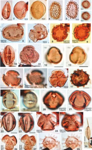
Palynological analysis of Missole samples are still ongoing to determine the age of the hole outcrops. Complete results will be presented in a future publication. However, primary results revealed palynomorphs rich-samples (Fig. 8). Palynomorphs are well preserved and assemblages consist of pollens, spores and dinocyst. In addition to many long-ranging or non-diagnostic palynomorphs, a good number of biostratigraphically relevant dinocysts and pollen were identified in the studied samples as well as lining forams. Pollen assemblages are illustrated by
Retitricolporites spp., Psilatricolpites spp., Psilastephanocolporites group (Psilastephanocolporites laevigatus, Psilatricolporites punctatus) ; Gemmatricolpites spp. ; Retimonocolpites spp. ; Spirosyncolpites spiralis; Bombacacidites spp., Saturna enigmaticus, Retistephanocolpites williamsi, Magnomonoporites gemmatus, Retitricolpites clarensis; Psilamonocolpites spp ; Longapertites spp., Proxapertites operculatus et P. cursus.
Some spores are also identified like Laevigatosporites ovatus.
Among the palynomorphs found, investigations also revealed the presence of some dynocyst such as,
Corsdosphaeridium spp.
Notice that Magnomonoporites gemmatus and Cordosphaeridium gracile found in Missole samples are highlighted for the first time in Cameroon.
Figure 8. Din-flagellum and microspores of the Missole clayey materials (Douala sub-basin); 1)Monoculcites sp., 2) Laevigatosporites ovatus ; 3) Proxapertites operculatus ; 4, 5) Spirosyncolpites spiralis ; 6,7) Saturna enigmaticus 8) Proxapertites cursus ; 9) Bombacacidites sp. ; 10,11) Retistephanocolpites williamsi ; 12) Psilatricolporites sp.1 ; 13) Retitricolpitessp. ; 14, 15) Retitricolpites clarensis ; 16, 17) Gemmatricolpites sp. ; 18)
Malgocolporites spp. ; 19) Magnomonoporites gemmatus ; 20, 21) Psilatricolporites punctatus ; 22, 23) Psiltricolporites crassus?; 24, 25) Psilatricolporites sp., 2 ; 26, 27) Indet ; 28,29) Tricolpites ; 30,31)
Cordosphaeridum gracile ; 32) Palaeocystodinium golzowense
5. Sequence Stratigraphy and NE-SW Evolution
The sequence stratigraphic interpretation presented here is based on the vertical relationship of the facies associations, and the existing stratigraphic framework of the N’kapa Fm succession. The complete section of Missole allows to recognize five sequences. Sequences were defined based on stratigraphic limits such as erosion boundaries, ferruginous layers considered as base level falls and clay abundance interpreted as aggradational trend.
Depositional sequences vary from continental/fluvial to shallow shelf deposits. The sequence boundaries are sharp and sometimes erosive. However, in continental environments, it is difficult to differentiate autocyclic factors, leading to stratigraphic base level variations. Erosional surface are numerous. Major erosional surfaces and well-developed palaeosols horizons are good indicator of long periods of continental alteration/weathering (Retallack, 1988). According to the same author, the three main field features of paleosols are root traces, soil horizons, and soil structures. In the Missole 1 outcrops, ferruginized root traces (P2, Table 1; Fig 5g) have been observed in association with Sur facies (Fig. 4d). The environment has been interpreted as bay. The lateral variability (stratigraphy) of soils within an alluvial basin reflects differences in relief and drainage. Paleosols and other ferruginous levels described will then be considered as formed during or slightly after relative sea level
falls. The frequent co-existence of disseminated fragments of coal and moulds of bivalves records both terrestrial and open marine sources for the sediments.
Sequences are described from the bottom to the top and five distinct facies associations typical of depositional environments have been identified and classified from continental to shallow marine with many transitional environments (Fig. 6). M1 and M2 sections seem to be identical since they are located one in front of the other while M3 is 4 km from M2 towards WNW with lateral facies variations and depositional environments.
Sequence 1
Sequence 1 is a progradational pattern situated at the basal part of M1 and M2 sections with a thickness of 0.4 to 2.65m. It is constituted of floodplain facies (Fmp, Fmb and Srb). Facies are strongly bioturbated except for indurated siltstone facies (Fmp) lying on clayey facies (Fmb). Fmp facies is overlain by bioturbated sandstones with ripples cross laminations. The boundaries between the interbedded facies constituting this sequence are sharp. The lateral evolution of this sequence towards M3 section shows a change in sedimentation. Facies in this part of the study area are made of silt and clay with subangular to subrounded gravels of quartz (facies Fm) associated with ripple cross laminated sands (facies Sr). The sequence here is 2.80m thick with an erosional top boundary.
Sequence 2
Sequence 2 also has a progradational trend and is located on the top of sequence 1. It is composed of fluvial deposits consisting in two layers of bioturbated sandstones (facies Srb) interbedded with a ripple cross sandstones layer (facies Sr) with unclear boundaries between layers. The entire sequence has a thickness of 1.45m and evolves laterally at M2 section to 2.20m of thickness. At M2 section, the sequence starts with bioturbated laminated sands (facies Slb) evolving gradually upward with bioturbated sands of Srb facies. The upper Sr facies lies on the erosive Srb top boundary. This sequence vary laterally at M3 to a more marine tendancy of mouth bar deposits constituted of Sb, Shb and Ssig facies. The sequence starts with sandstones deposits bioturbated by ophiomorpha (facies Sb) recovered by three successive levels constituted of a mixture of herringbones and sigmoid structured sandstones sometimes bioturbated of facies Shb and Ssig. These facies are top by a 1m layer of facies Ssig. Facies succession within this sequence is characterised by erosional boundaries. The entire sequence 2 which is 3.25m thick at M3, is bounded to the top by an erosional surface all along the Missole outcrops.
Sequence 3
The third sequence, located at the middle part of M1 and M2 sections is made of sandstones and fine facies. It is constitured of shoreface deposits beginning with bioturbated ungraded sands (Sub) followed by Su, Sgb and finally Fml facies. This sequence has a retrogradational trend with a thickness of 4.5m (at M1 section) to 5.25m (at M2 section). Boundaries between sandstones facies are unclear. The sequence is fining upward evolving from coarser facies (Sub, su and Sgb) to fines (Fml). Su facies appears at two different levels of the stratigraphic succession. The top of this sequence is made a minor retrogradational sequence (sequence 3’) appearing at 6.30m of the stratigraphic succession. The minor sequence begins with a thin bed of pebbles sand (facies Su) with erosional basal boundary and overlain by Fml facies. These deposits are interpreted as reworked transgressive lag deposits which grade upward to silt and clayey facies. The lag deposit facies (Su) in association with fine facies (Fml) are interpreted as floodplain deposits. The top of the sequence corresponds to a maximum flooding surface recognised within the aggradational trend of the other two sections.
The lateral evolution of this sequence towards M3 section correspond to shallow shelf sandstones deposits (facies Sb and Ssig). This sequence lies over the erosional top boundary of sequence 2 and is constituted of bioturbated sandstones (facies Sb) interbedded with several levels of Ssig facies bounded by erosional boundaries. The sequence ends with bioturbated clay and silt (facies Fb) with several indurated ferruginised and sometimes eroded boundaries. This facies has an aggradational tendency that would correspond to the minor sequence 3’ at M1 and M2 ending with a maximum flooding surface. The minor sequence is interpreted as a high level of water within restricted estuarine/embayment environment. The whole sequence 3 has a thickness of about 2.25m.
Sequence 4
The sequence 4 is a progradational sequence located over retrogradational deposits of sequence 3. Its thickness vary from 0.85 to 2m between M1 and M2 sections. The sequence starts with heterolithic silt and clay (facies Fml) marking the end of the retrogradational time. Fml facies is recovered by distal bay deposits of Sur and P2 facies indicating confined environments with rich swamp vegetation. The observed four levels of
rhizoconcretions (facies P2, Fig. 6a) indicate different phases of emersion. Sequence 4 evolves laterally at M2 and M3 sections without P2 facies. At M2, the succession is constituted Fml facies seperated from the ungraded sandstones (facies Su) by a sharp boundary. The lateral extension of this sequence at M3 correspond to a 1.30m thick of estuarine deposits (facies Fb) charcterised by several internal boundaries. These boundaries are ferruginised would correspond to periods of emersion observed at M1. The upper boundary of this sequence in the overall sections is sharp.
Sequence 5
Sequence 5 is a retrogradational sequence located in the upper part of the outcrops. This sequence is constituted of estuarine deposits of facies Ff. The facies is aggradational upward at M1, evolves laterally to heterolithic silt and clay (facies Fml) at M2 and is beveled towards M3 where it was not observed. The thickness of this sequence vary from 1.25m (at M1) to 0,5m (at M2). The upper boundary of the entire sequence correspond to a flooding surface only observed at M1 and M2 sections.
Sequence 6
Sequence 6 is progradational sequence located at the top of Missole outcrops. It is formed by a coarsening upward sequence moving from estuary deposits (facies Ff) to fluvial channels facies (Ss, Gcm and P1). The Ss facies lies on Ff deposits with flames structures appearing at its upper boundary. This structures resulted from the density contrast between Ss and Ff slightly after the deposition when sediments were not yet consolidated. Ss facies is overlain by Gcm facies constituted of subangular to subrounded gravels of quartz. The limit between Gcm and Ss is sharp and sometimes erosive. The upper facies of this sequence is constituted of ferruginous breccias (facies P1) lying on a sharp basal boundary. The sequence which is 3.25m thick and constituted of facies Ff, Ss, Gcm and P1 at M1, seems to have been eroded at M2 (constituted of Fml, Ss and Gcm, 1.40m of thickness) as well as M3 (constituted of Fb and Ss, 1m of thickness).
6. Discussion
According to Guiraud and Bosworth (1997), the Santonian unconformity that is identified across the whole African plate, was generated by an inversion related to the change in movement for the opening of the North Atlantic. On the equatorial West African margin, this event may correspond to a discrete phase of deformation that has the form of in situ folding of the platform sedimentary section and the inversion of the original rift-related roll-over structures (Lawrence et al., 2002). This has resulted in reducing accommodation space and decline of sedimentation rate in the equatorial Africa margin compared to the SW margin as demonstrated by (Seranne and Anka., 2005).
In old sequences, it is difficult to distinguish between coarse-grained deposits resulting from tectonism and those resulting from climatic events (Frostick and reid, 1989; Ritter et al., 1995). Tectonism was considered the primary control on sedimentation in general facies models for ancient alluvial fans (Heward, 1978; Nilsen, 1982) and on sequence stratigraphic models. But as suggested by (Frostick and reid, 1989), tectonism may create an environment suitable for coarse deposition by creating relief and accommodation space, but that, within the geographic framework, one or more climate changes may produce sufficient water and sediment discharge to initiate fan aggradation. The sequence stratigraphy pattern of these stratigraphic units could thus result from tectonic and climatic changes. These conditions are realised for depositional sequences which are not older than 3 My.
6.1 Age Discussion of Missole Deposits
Several species (Retistephanocolpites williamsi, Magnomonoporites gemmatus, Proxapertites operculatus, P.
cursus) found in this work were previously recorded from Maastrichtian-Eocene age in West Africa and South
America (Germeraad, Hopping & Muller, 1968; Salami, 1984, Rull, 2001, Atta-Peters and Salami, 2004; Eisawi and Schrank, 2008, Ngon Ngon et al., 2016). However some of them (Fig. 8) can have diagnostic age. Saturna enigmaticus is known Paleocene range age in Nigeria (Salard, 1979, 1990; Oloto, Soronnadi-Ononiwu, & Omoboriowo, 2016). Retitricolpites clarensis has been reported from Paleocene-Eocene range age in Nigeria and Cameroon (Salard-Cheboldaeff, 1979; Salard-Cheboldaeff, 1990; Awad, 1994). Several work show that Bombacacidites spp. appears in the Paleocene-Eocene transition in Nigeria (Germeraad et al., 1968), Eocene of Cameroon (Salard-Cheboldaeff, 1981), Paleocene of Guyana (Leidelmeyer, 1966), Paleocene-Eocene from Argentina (Del Papa, 1999). Psilastephanocolporites group appear to late Paleocene in Cameroon (Salard, 1979), so this group is not older than Thanetian. These species confirm that the sediments analysed are not older than Paleocene.
Lower-Upper Eocene, South England (Bujak, Downie, Eaton & Williams.,1980), Middle-Upper Eocene, offshore North West Africa (Williams, 1978), supports an early Eocene age for the Missole sediment. In the same way, Spirosyncolpites spiralis which was identified to early Eocene-early Miocene in Cameroon, Côte d’Ivoire and Columbia (Salard-Cheboldaeff 1979; Pardo-Trujillo, Carlos, Jaramillo., Francisca & Oboh-Ikuenobe , 2003; Digbehi et al., 2012) confirm the early Eocene age range.
Based on stratigraphic extensions of most known species, Thanetian age range proposed by Ngon Ngon et al. (2016) can be extends to early Eocene. Deposits seem then to be older around 3My, indicating a third sequence order.
6.2 Depositional Evolution and Tectonic
Segmentation of many rifted passive continental margins is a characteristic feature of their tectonic evolution (Daly, Chorowicz & Fairhead, 1989). Previous workers (Daly et al., 1989; Seranne and Anka., 2005, Manga, 2008; Djomeni et al., 2011) demonstrated this relationships between relative sea level change and tectonic by linking the evolution of the Douala sub-basin to the Santonian tectonics and Eocene sliding (Teisserenc and Villemin, 1989; Lawrence et al., 2002; Seranne and Anka., 2005). Robertson (1992) stated that equatorial portion of the South Atlantic continued to experience rapid extension during Early Paleocene and surrounding basins in this area undergo rapid subsidence. This has probably marked the outset of Missole deposits, consisting in progradational deposits of floodplain and lacustrine environment overlain by fluvial to mouth bar deposits. The period was followed by a marine transgression which started with deposition of lag deposits (facies Sub). This retrogradational body consisted mainly in shallow shelf to shoreface deposits. This sequence ended with a minor retrogradational sequence also starting with transgressive lag deposit (facies Su). According to (Regnoult, 1986) marine transgression has been favoured within this period by subsidence and attained its maximum in the Ypresian. The maximum of transgression would corresponds to the aggradational trend represented by heterolithic silt and clay facies (Fml facies). This represents the most important flooding episode within the study area. Palynological primary results helped to confirm and extend the Thanetian age of Ngon Ngon et al. (2016) to early Eocene age for these deposits. The upper part of Fml facies represents the outset of a new regressive stage constituted of progradational deposits of distal bay to estuary environment. This phase acted in four minor stages of regression corresponding to the four levels of rhizoconcretions and erosional surfaces found respectively at M1 and M3 sections. The regressive stage ended with setting of first deposits of clay and silt facies (Ff, Fig.6). This facies represents the outset of a new flooding stage only recorded at M1 and M2 and characterised by aggradational deposits of Ff and Fml facies. This stage was followed by a new regression marked by deposition of a coarsening upward sequence characterising a progradational sequence deposited through debris flow process.
Debris-flow deposits, poorly sorted and subangularity of clasts indicate a nearby source area and probably a slope. Sandstones with soft-sediment deformational structures were recognized by Djomeni et al. (2011) as recumbent folds as well as irregular convolutes and giant load structures associated to flame structures within the study area. These structures were interpreted as syn-sedimentary tectonic activities and related to reactivation of different fracture zones crossing the Douala-sub basin during Paleocene-Eocene sedimentation. The coarsest nature of sediments in upper part of Missole outcrops associated to syn-sedimentary structures, indicate slowing tectonic activity within upper progradational sequence deposited after the flooding episode of Ypresian. However, the nature of structures, their scarcity along outcrops attest of slowing tectonic. Sedimentation of Tertiary deposits in the Douala sub basin seems to have been controlled mostly by base level fluctuation with a minor tectonic role mostly induced by fracture zones reactivation.
6.3 Climate
Generally for the Missole deposits, the genetic sequences are asymmetrical, with the sea-level fall being better preserved than the sea-level rise (Fig. 6). Progradational sequences described in the study area are characterised by the presence ferruginous levels sometimes duricrust or rhizoconcretions assimilated to paleosols with red coulour. Retallack (1988, 2001) stated that variations in soil components, colour, and layering are related to climate conditions, source terranes, and rate of subsidence and sedimentation. Moreover, the study of climatic minerals indicators such as hematite, goethite, pyrite and siderite along the outcrops shown globally a contrary evolution. Hematite is always high inside indurated ferruginous layers develop. Highest values of hematite are correlated to progradational trend times (Fig. 6) while kaolinite and goethite highest values were found during retrogradation time. Hematite could thus be related to arid periods with base level falls while kaolinite and goethite development could be inferred to wet periods will base level rises. According to Miall (1996), the presence of hematite and siderite could indicate arid conditions. Kämpf and Schwertmann (1983) considered the
formation of goethite as favoured by cooler, wetter and less seasonal climatic conditions, when soil saturation becomes more likely. Restricted estuary/fluvial tidal influenced channel/embayment described at Missole and characterised by well-developed rhizoconcretions and other duricrusts could thus be related to warm to arid conditions while kaolinite abundance periods are inferred to wetter conditions.
7. Conclusion
Facies analysis of Tertiary deposits cropping out at Missole in the Douala sub basin allows the identification of different environments. The overall three sections studied exhibit many vertical and lateral transitions between facies. These variations characterise several environments: floodplain, lacustrine and fluvial environments, mouth bar, shallow shelf, distal bay and fluvial channels. Deposits attributed to the N’kapa Formation exhibit different processes of deposition. The lower part of these deposits was dominated by suspension and tractive currents processes, sometimes flow and ebb currents while the upper part shows high turbidity currents deposits represented by ferruginous breccias. These deposits with angular to subangular shape indicate a nearby source associated to a probable slope within the landscape while deposition.
Several erosional boundaries with various stratigaphic significations were recorded. Transgressive lag deposits found in this work lies on erosional surfaces that represent genetic sequence boundaries and initiate a retrogradation interval. Sequence analysis revealed progradational/retrogradational sequences induced by base level fluctuations and sediment supply. Within Missole outcrops, four progradational sequences punctuated by two flooding episodes were defined and a cycle of about 3 My was obtained thanks to palynological results. Base level fluctuations would thus correspond to climate change and local tectonic.
Studies of mineral abundance helped to evaluate conditions during the depositional process. Abundance of kaolinite and goethite is inferred to wet periods while good amount of hematite are considered as formed within dry periods. This confirm the hypothesis of a climate control of these deposits. The occurrence of some species like Psilastephanocolporites group and age-diagnostic dinoflagellate cysts such as Cordosphaeridium gracile (fig. 8) within Missole sediments permitted to extend Ngon Ngon et al. (2016) age evoked for these deposits from Thanetian to early Eocene precisely Thanetian – Ypresian.
Acknowledgments
The authors are greatful to Gah-Muti Syllvanus and Oben Mbeng Lawrence to have improved the English quality of this work.
References
Andreef, I. (1947). Etude du bassin sédimentaire de Campo, Rapport interne, Elf-Serepca, 58p.
Atta-Peters, D., & Salami, M. B. (2004b). Late Cretaceous to Early Tertiary pollen grains from offshore Tano Basin, Southwestern Ghana. Revista Española de Micropaleontologia, 36(3), 451-465.
Awad, M. Z. (1994). Stratigraphic, palynological and paleoecological studies in the East –Central Sudan (Khartown and Kosti Banns), Late Jurassic to Mid Tertiary, Berliner Geowissenschafliche Abhandlungen, (A)161, 163p.
Bachirou, M. C., Njike Ngaha, P. R., & Bitom, D. L. (2014). Sedimentary facies and depositional environments of Cenozoïc sedimentary Formations cropping out at the central part of the Douala basin. American Journal
of Geosciences, 4(1), 8-23.
Belmonte, Y. C. (1966). Stratigraphie du bassin sédimentaire du Cameroun, In: Proceeding of the 2nd West African Micropaleontologist Colloquium, Ibadan, Nigeria, 7-23.
Bourquin, S., Eschard, R., & Hamouche (2010). High-resolution sequence stratigraphy of Upper Triassic succession (Carnian–Rhaetian) of the Zarzaitine outcrops (Algeria): A model of fluvio-lacustrine deposits, Elsevier, Journal of African Earth Sciences, 22. https://doi.org/10.1016/j.jafrearsci.2010.04.003
Brownfield, M. E., & Charpentier, R. R. (2006). Geology and total petroleum systems of the West-Central Coastal Province (7203), West Africa. U.S. Geological Survey Bulletin 2207-B, 52.
Buatois, L. A., Mángano, M. G., Genise, J. F., & Taylor, T. N. (1998). The ichnologic record of the invertebrate invasion of nonmarine ecosys- tems: Evolutionary trends in ecospace utilization, environmental expansion, and behavioral complexity. Palaios, 13, 217-240.
Buatois, L. A., Mángano, G., Carr, & Timothy, C. (1999). Sedimentology and Ichnology of Paleozoic Estuarine and Shoreface Reservoirs, Morrow Sandstone, Lower Pennsylvanian of Southwest Kansas, USA: Current Research in Earth Sciences, Kansas Geological Survey Bulletin, 243, part 1, 35.
Bujak, J. P., Downie, C., Eaton, G. L., & Williams, G. L. (1980). Dinoflagellate cysts and acritarchs from the Eocene of southern England. Special Papers in Palaeontology, 24(100), 1-22.
Chakavorty, A., & Ghosh, D. K. (1991). Kaolinite-Mullite reaction series. Journal of the American ceramic
society, 74, 1401-1406.
Champetier de ribes G., & Reyre D. (1957). Carte géologique de reconnaissance à l’échelle du 1/500000. Feuille Yaounde-Ouest, Cameroun, Direction des mines et de la géologie.
Daly, M. C., Chorowicz, J., & Fairhead, J. D. (1989). Rift basin evolution in Africa: the influence of reactivated steep basement shear zones. In: Cooper, M. A., Williams, G. D. (Eds.), Inversion Tectonics, Geological Society. Special Publication, 44, 309–335.
Dartevelle, E., & Brebion, P. (1956). Mollusques fossiles du Crétacé de la Côte occidentale d'Afrique du Cameroun à l'Angola. 1. Gastéropodes. Annales du Musée royal du Congo belge. Sciences Géologiques, 15, 1-128.
Dartevelle, E., & Freneix, S. (1957). Mollusques fossiles du Crétacé de la Côte occidentale d'Afrique du Cameroun à l'Angola. 2.- Lamellibranches. Annales du Musée royal du Congo Belge, 20, 1-271.
Del Papa, C. E. (1999). Sedimentation on a ramp type lake margin: Paleocene-Eocene Maiz Gordo Formation, northwestern Argentina. Journal of South American Earth Sciences, 12, 389-400.
Digbehi, Z. B., Doukoure, M., Tea-Yassi, J., Yao, R. K., Yao N’Goran, P., Kangah, K. D., & Tahi, I. (2012). Palynostratigraphy and palaeoenvironmental characterization and evidence of Oligocene in the terrestrial sedimentary basin, Bingerville area, Southern Côte d’Ivoire, Northern Gulf of Guinea. African Journal of
Environmental Science and Technology, 6(1), 28-42.
Djomeni, A. L., Ntamak, M. J., Mvondo, F., Fowe, P. G., Iboum, J. B., & Mooh, E. (2011). Soft-sediment deformation structures in Mid- Cretaceous to Mid-Tertiary deposits, Centre East of the Douala sub-basin, Cameroon: Preliminary results of the tectonic control, Syllabus Review, 2(3), 92-105.
Dumort J. F. (1968). Identification par la télédétection de l'accident de la Sanaga (Cameroun). Géodynamique, 1, 13-19.
ECL (2001). An integrated study of structural development source rock maturity and hydrocarbon generation in the Douala/Kribi-Campo Basin. Republic of Cameroon. Internal report SNH, 185.
Eisawi, A., & Schrank, E. (2008). Upper Cretaceous to Neogene Palynology of the Melut basin, southeast Sudan.
Palynology, 32, 101-129.
Frostick, L. E., & Reid, I. (1989). Is structure the main control on sedimentation in rifts? Journal of African
Earth Sciences, 8, 168-182.
Germeraad, J. H., Hopping, C. A., & Muller, J. (1968). Palynology of Tertiary sediments from tropical areas.
Review of Palaeobotany and Palynology, 6, 189-348.
Guiraud, R., & Bosworth, W. (1997). Senonian basin inversion and rejuve-nation of rifting in Africa and Arabia: synthesis and implications to plate-scale tectonics. Tectonophysics, 282, 39–82.
Hasiotis, S. T., & Bourke, M. C. (2006). Continental trace fossils and museum exhibits: displaying burrows as organism behaviour frozen in time. The Geological Curator, 8(5), 211-226.
Hasiotis, S. T., Platt, B. F., Hembree, D. I., & Everhart, M. J. (2007). The Trace-Fossil Record of Vertebrates, Elsevier, pp. 190 – 212.
Heward, A. P. (1978). Alluvial fan sequence and megasequence models: with examples from Westphalian D-Stephanian B coalfields, northern Spain. In: Miall, A. D (Ed.) Fluvial sedimentology, Canadian Society of Petroleum Geologists, Memoirs 5, 669 – 702.
Holtzapffel, T. (1985). Les mineraux argileux : Preparation, Analyse diffractometrique et détermination. Société
Géologique Nord, 12, 1-136.
Kämpf, N., & Schwertmann, U. (1983). Goethite and hematite in a climosequence in Southern Brazil and their application in classification of kaolinitic soils. Geo-Derma, 29, 27-39.
Lawrence, S. R., Munday, S., & Bray, R. (2002). Regional geology and geophysics of the eastern Gulf of Guinea (Niger Delta to Rio Muni). The Leading Edge, 1113-1117.
Mededelingen, 38, 49-70.
Lowe, D. R. (1982). Sediment gravity flows: II. Depositional models with special reference to the deposits of high-density turbidity currents. Journal of Sedimentary Petrology, 52, 279-297.
Manga, C. S. (2008). Stratigraphy structure and prospectivity of the Southern onshore Douala Basin Cameroon – Central Africa, In Guest Editors: Ntamak-Nida MJ, Ekodeck GE, Guiraud M. Cameroon and neighboring basins in the Gulf of Guinea (Petroleum Geology tectonics Geophysics Paleontology and Hydrogeology).
African Geosciences Review Special Publication, 1 & 2, 13-37.
Marshall, J. D. (2000b). Sedimentology of a Devonian fault-bounded braidplain and lacustrine fill in the lower part of the Skrinkle sandstones, Dyfed, Wales. Sedimentology, 47, 325-342.
Meyers, J. B., Rosendahl, B. R., Groschel-Becker, H., Austin, Jr. J. A., & Rona, P. A. (1996). Deep penetrating MCS imaging of the rift – to drift transition, offshore Douala and North Gabon basins, West Africa. Marine
and Petroleum Geology, 13(7), 791-835.
Miall, A. D. (1978). Lithofacies types and vertical profile models in braided river deposits: a summary. In Miall, A. D. (Ed.), Fluvial Sedimentology, vol. 5. Memoir of Canadian Society of Petroleum Geology, 5, 859. Miall, A. D. (1996). The geology of fluvial deposits. Sedimentary facies, Basin analysis and petroleum geology,
xvi, 582p.
Mulder, T., & Alexander, J. (2001). The physical character of subaqueous sedimentary density flows and their deposits. Sedimentology, 48, 269-299.
Nemec, W., & Steel, R. J. (1984). Alluvial and coastal conglomerates: their significant features and some comments on gravelly mass-flow deposits. In Koster, E. H., & Steel, R. J. (Eds.), Sedimentology of Gravels
and Conglomerates (vol. 10, pp. 1–31). Memoir of Canadian Society of Petroleum Geology, Calgary. Ngon Ngon, G. F., Etame, J., Ntamak-Nida, M. J., Mbesse, C. O., Mbaï, J. S., Bayiga, E. C., & Gerard, M.
(2016). Geochemical and palaeoenvironmental characteristics of Missole I iron duricrusts of the Douala sub-basin (Western Cameroon). Comptes Rendus Geoscience (2016). https://doi.org/10.1016/j.crte.2015.10.006
Nguene, F. R., Tamfu, S .F., Loule, J. P., & Ngassa, C. (1992). Paleoenvironments of the Douala and Kribi/Campo sub-basins, in Cameroon, West Africa. In: Curnelle, R. (Ed), Géologie Africaine. 1er Colloque de Stratigraphie et de Paléogéographie des Bassins Sédimentaires Ouest-Africains, 2ème Colloque Africain de Micropaléontologie, 6–8 Mai 1991, Libreville, Gabon. Bulletin du Centres de Recherche. Exploration-Production, Elf Aquitaine, 13, 129-139.
Nilsen, T. H. (1982). Alluvial fan deposits, in Scholle, P.A., and Spearing, D., eds., Sandstone depositional environments: Tulsa, Oklahoma, American Association of Petroleum Geologists, 49 – 86.
Oloto, I. N, Soronnadi-Ononiwu, G. C., & Omoboriowo, A. O. (2016). Palynology and Paleoenviromental studies of Umuna-1 well. Anambra and Niger delta Basins, Nigeria. Nova Journal of Engineering and
Applied Sciences, 7.
Parcha, S. K., & Singh, B. P. (2005). Palaeoecological signification of ichnofossils from the Early Cambrian succession of Spiti Valley, Tethys Himalaya, India. Current Science, 88(1), 158-162.
Pardo-Trujillo, A., Carlos, A., Jaramillo., Francisca, E., & Oboh-Ikuenobe. (2003). Paleogene palynostratigraphy of the Eastern middle Magdalena Valley, Colombia, 2003. https://doi.org/10.2113/27.1.155
Posamentier, H. W., & Vail, P. R. (1988). Eustatic controls on clastic deposition. II. Sequence and systems tract models. In Wilgus, C. K., Hastings, B. S., Kendall, C. G. St. C., Posamentier, H. W., Ross, C. A., & Van Wagoner, J. C. (Eds.), Sea Level Changes – An Integrated Approach. SEPM Special Publication, 42, 125-154.
Postma, G. (1990). Depositional architecture and facies of river and fan deltas: a synthesis. In Colella, A., Prior, D. B. (Eds), Coarse-grained Deltas. Special Publications of International Association of Sedimentologist, 10, 13-28.
Regnoult. (1986). Synthèse géologique du Cameroun. D.M.G., Yaoundé, Cameroun, 118 p.
Retallack, G. J. (1988). Field recognition of paleosols. In J. Reinhardt & W. R. Sigleo (Eds.), Paleosols and weathering through geologic time: techniques and applications, Geological Society of America, special