HAL Id: hal-01169294
https://hal.archives-ouvertes.fr/hal-01169294
Submitted on 29 Jun 2015HAL is a multi-disciplinary open access archive for the deposit and dissemination of sci-entific research documents, whether they are pub-lished or not. The documents may come from teaching and research institutions in France or abroad, or from public or private research centers.
L’archive ouverte pluridisciplinaire HAL, est destinée au dépôt et à la diffusion de documents scientifiques de niveau recherche, publiés ou non, émanant des établissements d’enseignement et de recherche français ou étrangers, des laboratoires publics ou privés.
Urban Vulnerabilities in Andean Countries. General
Introduction
Robert d’Ercole, Sébastien Hardy, Pascale Metzger, Jérémy Robert
To cite this version:
Robert d’Ercole, Sébastien Hardy, Pascale Metzger, Jérémy Robert. Urban Vulnerabilities in Andean Countries. General Introduction. Bulletin de l’Institut Francais d’Etudes Andines, Institut Français d’Etudes Andines (IFEA), 2009, Vulnerabilidades urbanas en los paises andinos (Bolivia, Ecuador, Peru), 38 (3), pp.421-429. �hal-01169294�
Urban Vulnerabilities in Andean Countries. General Introduction
Bulletin de l’Institut Français d’Études Andines / 2009, 38 (3): 421-429
IFEA
Urban Vulnerabilities in Andean Countries
General Introduction
Robert D’Ercole
*Sébastien Hardy
**Pascale Metzger
*Jérémy Robert
*** 1. Urban VUlnerabilitiesThis thematic issue of the Bulletin de l’Institut Français d’Études Andines aims at contributing to the knowledge on urban vulnerability in three Andean countries: Bolivia, Ecuador, and Peru. Urban vulnerability is seen as the difficulty for cities to anticipate and cope with physical or man-made phenomena (earthquakes, floods, landslides, fires, explosions, pollution, etc.) likely to cause damages, to resist them and recover after they occurred (Blaikie et al., 1994). It is also seen as the ability of cities and their inhabitants to produce the conditions of the occurrence of such phenomena or, at least, worsen its effects (D’Ercole et al., 2009).
Due to increasing urbanization, often with a lack of a long-term perspective, and an unfavourable geodynamic and climate context, these three Andean countries face a great deal of risks. Such risks frequently lead to disasters that severely affect * Institut de Recherche pour le Développement (IRD), UR 029, PACIVUR programme, Calle Teruel
357, Miraflores, Casilla 18-1209, Lima 18, Perú. E-mails: [email protected];
** Institut de Recherche pour le Développement (IRD), UR 029, PACIVUR programme, Av. Hernando Siles 5290 esq. calle 7, CP 9214 Obrajes, La Paz, Bolivia. E-mail: [email protected]
*** Institut Francais d’Études Andines (IFEA, UMIFRE 17, CNRS-MAEE)-Université de Savoie, CISM, Laboratoire EDYTEM (CNRS). E-mail: [email protected]
Robert D’Ercole, Sébastien Hardy, Jérémy Robert, Pascale Metzger the population, infrastructures, public and private goods, their economy and, consequently, the conditions of their development. The national territories are globally concerned, but the urban areas seem to be more and more affected by these disasters. Indeed, their total population amounts to 50 million inhabitants, of which more than 70 % live in urban areas1. In general, the growth rate of urban
population has experienced a slight recession over the last decades. However, urban population continues to grow, resulting in extension and densification of the cities, regardless of any risks and vulnerabilities.
Urban vulnerability in Andean countries is considered in a more comprehensive framework. By 2030, global urban population will reach 5 billion inhabitants and cities of the developing world will host over 80 % of the world’s urban population (UNFPA2, 2007). These forecasts are based on hypotheses on steady urban growth
rates in Latin America, strong in Asia, and explosive in Africa. Moreover, this urban population is very concentrated in space, barely 1 % of the terrestrial surface (Pelling, 2003). These quantitative data are often provided in order to explain the increasing vulnerability of the cities, in particular the cities of the South, to natural and/or man-made disasters, and report on the fact that the list of cities struck by major disasters keeps diversifying and getting longer (Dubois-Maury & Chaline, 2002). However, they are only meaningful if associated with the qualitative transformations of urban agglomerations that contribute significantly to their vulnerability.
Researchers draw attention to the increasing complexity of the cities (Pigeon, 1996; Pigeon 2007): ever increasing dependency of the urban areas to major public utility systems (Dubois-Maury & Chaline, 2002), ever stronger multiplication and interlacing of such systems and power, energy or information flows (Pelling, 2003). They also put the emphasis on the negative effects of the pace of urbanization dynamics that can be viewed from different angles (D’Ercole, 1994; Lavell, 1999; Pelling, 2003): environmental degradations (artificialization of the soils, overexploitation of natural resources, pollution, etc.); transformation of urban sites, spreading and ever increasing occupation of spaces of risk (sloped sites, flood beds of rivers, etc.); often inappropriate building systems; absence of control; absence or poor quality of infrastructures and urban services; legislators and planners who cannotmonitor such transformations, etc.
The conditions in which the cities from developing countries become more complex and change, only intensify the vulnerabilities associated with poverty3,
social exclusion, spatial deprivation, a history of mistakes, special interests, and non-interventionism in terms of urban management and planning, as well as governance systems for which risks are not a priority. Such conditions of 1 8 274 325 inhabitants and 62.4 % of urban population in Bolivia (INE census, 2001); 14 005 449
and 65.7 % in Ecuador (INEC forecasts, 2009); 27 412 157 and 75.9 % in Peru (INEI census, 2007).
2 United Nations Fund for Population Activities.
urbanization in developing countries are also linked with economic and social transformations resulting from a universalistic approach of development that, by definition, overcomes local conditions, whether physical, social or cultural. A great deal of urban space in developing countries is not subject to planning according to its classic meaning. The city has two sides: the modern and planned city and the self-constructed and unequipped city; the legal city and the illegal city (D’Ercole
et al., 2009).
To these conditions of great urban fragility, resulting from the modalities of urban and development production, we can add the exposure to natural or man-made hazards. In 1995, it was considered that over 40 % of urban population in developing countries was exposed to natural hazards (D’Ercole & Thouret, 1995). On the other hand, Chester (2002) underlines that 86 of 100 major cities of developing countries are exposed to destructive hazards (earthquakes, tsunamis, floods, volcanic eruptions, etc.). The consequences of such exposure and the conditions of urban development in developing countries are extremely harmful. As already noted by Renaud Vié-le Sage in 1989, more than 90 % of the victims of natural disasters live in developing countries, and each disaster causes on the average 30 times as many victims as in rich countries4. The list of urban disasters
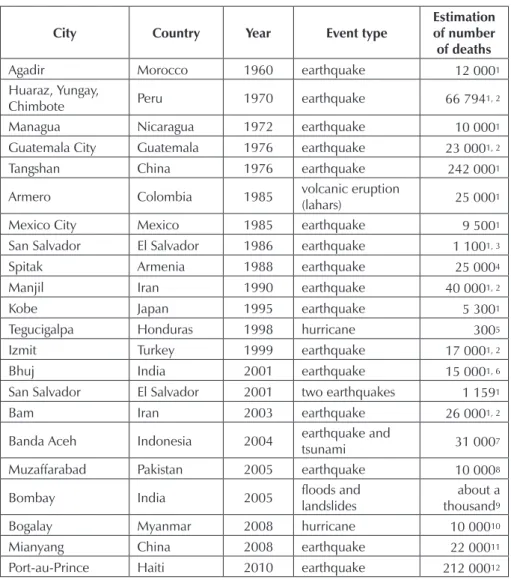
sustaining this argument is particularly long and is getting inexorably longer (table 1). These examples of urban disasters, most of them caused by earthquakes, but also hurricanes or volcanic eruptions, claim thousands of deaths, or even tens of thousands of deaths.
For the three Andean countries taken into account in this volume, we must go back several decades in order to find similar disasters. In Ecuador, the city of Pelileo was destroyed by an earthquake in 1949, claiming more than 6 000 deaths. If we go back further in time, other cities have been destroyed by earthquakes like, for example, Riobamba in 1797 (6,000 to 20,000 deaths according to the estimations). The city of Latacunga was destroyed repeatedly by lahars (debris and mudflows) caused by the eruptions of the Cotopaxi volcano (1742, 1768, 1877). In Peru, an earthquake followed by a tsunami destroyed Lima and Callao in 1746 (more than 3,000 victims). The earthquake of 1970 (70,000 deaths) is still alive in the minds of Peruvians. It mainly destroyed the city of Huaraz and the town of Yungay, which was struck by a mudflow caused by the collapse of part of the Huascarán glacier. More recently, on August 15, 2007, several small cities, including Pisco and Chincha Alta, have been affected by another earthquake claiming several hundreds of victims and destroying tens of thousands of homes. In 1687, Pisco had already been moved following an earthquake (Musset, 2002). On the other hand, Bolivian cities have never registered major disasters, at least in terms of human lives. This fact is partly linked to a lesser urban population in Bolivia
4 Similarly, Albouy indicates that 75 % of the victims of natural disasters come from the poorest
countries, 23 % from middle-income countries, and 2 % from OECD (Organization for Economic Co-operation and Development) countries (Albouy, 2002: 40)
Robert D’Ercole, Sébastien Hardy, Jérémy Robert, Pascale Metzger
until the government decided to develop the urban axis of La Paz-Cochabamba-Santa Cruz5. The floods that occurred in La Paz on February 19, 2002, causing 69
deaths as well as important material damages, can be considered as one of the biggest urban disasters in Bolivia.
table 1 – examples of urban disasters on a world scale
5 It began in the mid-1950s and increased in 1990.
City Country Year event type estimation of number
of deaths
Agadir Morocco 1960 earthquake 12 0001
Huaraz, Yungay,
Chimbote Peru 1970 earthquake 66 7941, 2 Managua Nicaragua 1972 earthquake 10 0001
Guatemala City Guatemala 1976 earthquake 23 0001, 2
Tangshan China 1976 earthquake 242 0001
Armero Colombia 1985 volcanic eruption (lahars) 25 0001
Mexico City Mexico 1985 earthquake 9 5001
San Salvador El Salvador 1986 earthquake 1 1001, 3
Spitak Armenia 1988 earthquake 25 0004
Manjil Iran 1990 earthquake 40 0001, 2
Kobe Japan 1995 earthquake 5 3001
Tegucigalpa Honduras 1998 hurricane 3005
Izmit Turkey 1999 earthquake 17 0001, 2
Bhuj India 2001 earthquake 15 0001, 6
San Salvador El Salvador 2001 two earthquakes 1 1591
Bam Iran 2003 earthquake 26 0001, 2
Banda Aceh Indonesia 2004 earthquake and tsunami 31 0007
Muzaffarabad Pakistan 2005 earthquake 10 0008
Bombay India 2005 floods and landslides thousandabout a 9 Bogalay Myanmar 2008 hurricane 10 00010
Mianyang China 2008 earthquake 22 00011
Port-au-Prince Haiti 2010 earthquake 212 00012
Sources: 1. CRED (Centre for Research on the Epidemiology of Disasters); 2. La Documentation
Française; 3. DesInventar; 4. NSSP (Armenian National Survey for Seismic Protection); 5. Diario de Centro América; 6. Tribune de Genève; 7. Khaleej Times; 8. World Bank; 9. EchoGéo; 10. Le Monde; 11. Website official of Mianyang, may 31, 2008; 12. The Civil Protection Agency of the
Such major disasters are almost inexistent in Bolivia, and relatively infrequent, on a human scale, in Peru and Ecuador. On the other hand, the cities of the three Andean countries have registered many events of a minor nature linked to phenomena such as floods, landslides, technological accidents, fires or accidental pollution. The addition of these damages is very significant in human and material terms, affecting the economic and social development of these cities. In Lima, for example, about 3,000 events of this type have been registered since 1970, representing 80 events each year, with the most vulnerable and marginalized neighbourhoods being the most affected.
2. the PaCiVUr Programme
In this context, the PACIVUR research programme (Andean Programme for Training and Research on Vulnerability and Risks in Urban Environments) was launched in April 2006 within the framework of a scientific cooperation agreement between the IRD (Institute of Research and Development) and the CAN (Andean Community). A collaboration agreement has also been signed with the IFEA (French Institute of Andean Studies, UMIFRE 17, CNRS-MAEE), and with the European programme PREDECAN (Support for the Prevention of Disasters in the Andean Community) on institutional support to the CAN. Close connections, sometimes reinforced through agreements6, have been developed between the municipalities of La Paz,
Lima and Quito, and universities7, the Civil Defense, NGO such as the Italian
NGO COOPI8, and international institutions such as ECHO9.
PACIVUR arises out of the research programme «Information systems and risks in the metropolitan area of Quito» developed within the framework of a collaboration between the IRD and the municipality of Quito between 1999 and 2004, which constitutes the IRD first research initiative on urban vulnerabilities in South America, focusing on Quito. Its original approach (based on the city’s territorial issues), the numerous methodologies of analysis of vulnerability, as well as the results obtained for the municipality of Quito, contributed to the success of this first programme. As a consequence, its extension to a regional scale has been taken into account. PACIVUR focuses on three Andean countries: Bolivia, Peru and Ecuador, countries where the IRD established permanent offices10.
The PACIVUR programme has three complementary objectives: the production of useful knowledge for risk management and reduction, especially in the field of 6 Conventions with the municipality (Gobierno Municipal) of La Paz, the IMP (Instituto Metropolitano
de Planificación de Lima) and the INDECI (Instituto Nacional de Defensa Civil del Perú).
7 Among these universities: the Universidad Nacional Mayor de San Marcos, Lima (UNMSM); the
Pontificia Universidad Católica del Ecuador, Quito (PUCE); the Universidad Mayor de San Andrés, La Paz (UMSA).
8 Cooperazione Internazionale (http://www.coopi.org/). 9 European Commission Humanitarian aid Office.
10 Website : http://www.bo.ird.fr/ (Bolivia) ; http://www.ec.ird.fr/ (Ecuador) ; http://www.peru.ird.fr/
Robert D’Ercole, Sébastien Hardy, Jérémy Robert, Pascale Metzger social, political and territorial vulnerability; the disclosure in the Andean region of the scientific findings, which is the direct subject of this thematic issue; the creation of a regional potential for research and reflection on vulnerability and risks in urban environments through the training of young Andean and French researchers. The research developed within the framework of the PACIVUR programme through different research projects focuses on two different approaches. Firstly, it aims at understanding how vulnerability emerges in cities of the Andean countries, characterizing and evaluating this vulnerability, as well as evaluating its scope in terms of risks or damages. Secondly, it aims at analyzing to reduce procedures this vulnerability both in terms of prevention (preventive urban planning) and crisis management.
3. objeCtiVes and organization of this thematiC issUe
The objective of this issue is to present the main results of the scientific research conducted on urban vulnerability in the three Andean countries by the PACIVUR team along with several associated researchers, since the launching of the programme in April 2006. A total of 20 people have contributed to the drafting of this volume, most of them geographers11. It focuses essentially on the three
capitals —La Paz, Lima and Quito— towards which scientific activities have been oriented12.
As we underlined above, PACIVUR is a research programme as well as a training programme for young Andean and French researchers on urban vulnerability. That is why the primary objective of this thematic issue is publishing the results of research conducted during three years, as well as contributing to the training of young researchers, of whom some had never published scientific articles. This thematic issue has been published in collaboration with several young and experienced researchers and constituted a platform in order for younger researchers to be published.
This volume consists of four parts, each representing pertinent and complementary approaches to urban vulnerability in Andean countries.
the first part examines the past events in order to learn from them in terms
of vulnerability: the «underlying» vulnerability resulting from socio-historical processes on the long run, and the «circumstantial» vulnerability linked to the actual context and to the crisis management characteristics, which constitutes the first research initiative on urban vulnerabilities focusing on Quito is set forth in the article of R. D’Ercole, S. Hardy and J. Robert. This general presentation allows a better understanding of the conditions of their vulnerability, as well as reflecting on the information available for this type of exercise and the insufficiency of existing 11 One sociologist, one architect, one geomatic engineer and one computer scientist have also
participated to the drafting and writing of this thematic issue.
12 Except for the province of Chincha, in Peru, where research works have been carried out on the
databases. In a second phase, the statistical and cartographic approach is set aside, in order to delve into each event so as to better understand its social building and scope, both territorial and institutional, beyond the physical phenomenon. Seven case studies are set forth, covering a wide variety of situations (places, types of phenomena, extension of territorial effects, oldness of the event, etc.). Two events regarding Lima: the district of Lurigancho-Chosica affected by torrential flows in 1987 (C. Abad) and the Margen Izquierda del Río Rimac (Cercado de Lima) affected by the earthquake of August 15, 2007 (J. Robert and R. D’Ercole). S. Hardy presents two other case studies regarding La Paz. The first one is the crisis caused by the floods of February 19, 2002; the second one is the crisis in 2008 following the disruption of water supply in most of the La Paz due to a damaged pipe. The three other case studies focus on Quito. They recount and analyse the crisis situations caused by the Guagua Pichincha volcano activity in 1998-1999 (R. D’Ercole, P. Metzger and A. Sierra), a great fire in 2003 in the neighbourhood of Santa Rosa de Chillogallo (J. Estacio), and, in 2008, the pavement collapse in El Trebol, a key location for mobility in Quito (D. Salazar, F. Demoraes, N. Bermudez and S. Zavgorodniaya). These case studies have been carried out according to a common methodology which allows comparison of data. Finally, a synthesis is presented in order to learn from the consequences, factors of vulnerability, and impacts of the analysed events (text by R. D’Ercole, S. Hardy and J. Robert).
the second part of this thematic issue questions the past and current building
and consolidation processes of vulnerability. Through the analysis of two sectors in Lima (Margen Izquierda del Río Rimac —Cercado de Lima— and El Agustino), J. Robert and A. Sierra show how the representations of the risk, the institutional framework and the different governments of urban territories are at the centre of the building of vulnerability. At the same time, the absence of cooperative public policies focusing on risk prevention contributes to the consolidation of this vulnerability. The mechanisms of reinforcement of vulnerability also appear in case studies regarding the province of Chincha, severely affected by the earthquake of August 15, 2007. Based on an investigation conducted on 1,703 families affected by the earthquake, the article by R. D’Ercole, R. Cavagnoud, M. Morel and P. Vernier underlines the increase of the vulnerability and the degradation of the living conditions of thousands of families. This reinforcement of the vulnerability of the poorest people is explained in particular by an insufficient, inappropriate, and unequal rebuilding assistance policy. On the other hand, the article by J. Estacio shows, through a historic, social and territorial approach, how technological risk is built and transformed around the Beaterio, the main fuel storage centre in Quito. It analyses the consequences of the choices made by public authorities in order to reduce the risk —such choices focus essentially on having control over the hazards, instead of the urbanization. M. Durand and P. Metzger adopt a different approach to how vulnerability is built in Lima based on a solid waste basis. They present an analysis of the production of spaces through waste management. They explain how this management produces a transfer of the vulnerability from productive spaces to other poor and marginalized places, whose role is fundamental in terms of waste processing, considering the absence of public authorities in this field.
Robert D’Ercole, Sébastien Hardy, Jérémy Robert, Pascale Metzger The last article by J. Robert, T. Serrano, R. D’Ercole and P. Pigeon, based on the
Valle de Los Chillos (Quito, Ecuador) exposed to the eruptions of the Cotopaxi
volcano, shows how the complexity associated with the uncertainty results in vulnerability. It underlines the fact that reducing the risk meets the need to act under uncertainty, and that it is possible to reduce this uncertainty by unravelling the strands of complexity. It also presents geographic research works with this same purpose.
the third part addresses the issue of vulnerability reduction within the framework
of urban policies of risk management carried out in the three capitals. Firstly, the article by S. Hardy focuses on the evolution of such policies in La Paz, both in time and space: emphasis has successively been put on urban planning, then on the building of remedial works, and, at present, on the management of crisis situations. This highlights the limits of prevention policies. In Quito, risk control policies are also based on planning logic developed for the long run. In this context, the article by A. Sierra describes the evolution of planning carried out on the flanks of the Pichincha volcano, which is characterized by a more explicit recognition of social vulnerability, and explores the arguments behind this planning. In the case of Lima presented by A. Sierra, J. Robert, M. Durand and C. Abad, risk prevention policies in the capital are limited to specific actions. These limited actions, on a spatial and sectional basis, reflect a significant weakness: the lack of a metropolitan policy on risk management in Lima. The article by S. Hardy and E. Combaz takes into account the increasing involvement of the Bolivian public authorities in the field of risk management. It focuses more specifically on the problems of relocating the disaster victims to La Paz in the context of shortage of a risk-free urbanizable lands.
the fourth part, divided into five articles, explores the reduction of vulnerabilities
based on the researchers’ contribution in terms of scientific, conceptual, methodological and tool approaches. The analysis of vulnerability of urban road networks constitutes a very pertinent approach in order to understand the territorial vulnerability of great cities. This is what J. Nuñez and F. Demoraes show based on the case of La Paz and secondarily on Quito (insert). According to D. Salazar and R. D’Ercole, and based on the research carried out in the Valle de Los Chillos (Quito), the studies on the perception of risk link, in a constructive way, the points of view of the different actors potentially involved in a volcanic crisis (population, scientists, authorities). These are extremely useful in terms of crisis management preparation. The article by S. Hardy focuses on the evaluation and management of vulnerability in the districts 5 and 6 of the municipality of El Alto. It provides a good example of applied research supporting a project of disaster preparedness financed by the European Commission and managed by the NGO COOPI. The article by R. D’Ercole and P. Metzger concentrates on the interest of geographic research problematics questioning the spatial dimensions of crisis management. The authors present the contributions of a research on spatial articulation between vulnerable spaces and resource spaces of crisis management, and suggest a first application on the case of health care institutions in Quito. The last article (P. Metzger and R. D’Ercole) puts greater emphasis on the concepts guiding scientific approaches. Based on different examples and works carried out on vulnerabilities
and urban crises, the article presents a first theoretical reflection of the notion of vulnerability transmission, essential in order to understand and manage the risks incurred within urban territories.
Cited references
ALBOUY, F.-X., 2002 – Le temps des catastrophes, 172 pp.; Paris: Descartes & Cie. BLAIKIE, P., CANNON, T., DAVIS, I. & WISNER, B., 1994 – At risk. Natural people’s
vulnerability and disasters, 280 pp.; New-York: Routledge.
CHESTER, D. K., 2002 – Overview: hazard and risk. In: Applied Geomorphology: theory
and practice (R. J. Allison, ed): 251-264; Chichester: John Willey and Sons.
D’ERCOLE, R., 1994 – Les vulnérabilités des sociétés et des espaces urbanisés : concepts, typologie, modes d’analyse. Revue de Géographie Alpine, n.° 4, t. lXXXii: 87-96. Special Issue: « Croissance urbaine et risques naturels dans les montagnes des pays en développement) ».
D’ERCOLE, R. & THOURET, J.-C., 1995 – Croissance urbaine et risques naturels : présentation introductive. Bulletin de l’Association de Géographes Français, n.° 4 : 311-338. Special Issue: « Croissance urbaine et risques naturels (en particulier dans les pays en développement ».
D’ERCOLE, R., GLUSKI, P., HARDY, S. & SIERRA, A., 2009 – Vulnérabilités urbaines dans les pays du Sud. Présentation du dossier. Cybergeo : European Journal of Geography. [In lign], Dossiers, Vulnérabilités urbaines au sud, URL : http://www.cybergeo.eu/ index22151.html
DUBOIS-MAURY, J. & CHALINE, C., 2002 – Les risques urbains 208 pp.; Paris: Armand Colin.
LAVELL, A., 1999 – Gestión de riesgos ambientales urbanos, 15 pp.; Quito: FLACSO, La Red. http://www.desenredando.org/public/articulos/1999/grau/index.html.
MUSSET, A., 2002 – Villes nomades du nouveau monde, 398 pp.; Paris: Ed. EHSS. PELLING, M., 2003 – The vulnerability of cities: natural disasters and social resilience,
256 pp.; London: Earthscan.
PIGEON, P., 1996 – La gestion des risques urbains. In: Risques naturels, risques de sociétés (A. Bailly ed.): 51-62; Paris: Economica.
PIGEON, P., 2007 – L’environnement au défi de I’urbanisation, 189 pp.; Rennes: PUR. UNFPA, 2007 – État de la population mondiale 2007. Libérer le potentiel de la croissance
urbaine - http://www.unfpa.org/swp/2007/french/introduction.html
VIÉ-LE-SAGE, R., 1989 – La terre en otage. Gérer les risques naturels majeurs, 246 pp.; Paris: Seuil.