GJI
Seismology
Reconstructing the damage field of the 1855 earthquake in
Switzerland: historical investigations on a well-documented event
Stefan Fritsche, Donat F¨ah, Monika Gisler and Domenico Giardini
Swiss Seismological Service, Institute of Geophysics, ETH-Hoenggerberg, HPP L4, 8093 Zurich, Switzerland. E-mail: [email protected]
Accepted 2006 March 7. Received 2006 March 7; in original form 2005 May 24
S U M M A R Y
The 1855 earthquake at Visp remains the strongest in the last 300 yr in Switzerland. It caused heavy damage in the region of the middle Valais. We reconstructed the damage field of this event studying also site effects and building vulnerability. The key factors in such a study are the availability and accessibility of sufficient historical data. Given the existence of a complete contemporary damage assessment and the availability of early statistics, our investigation drew upon an excellent pool of data. These sources enabled us to quantitatively analyse the damage field on the village level. Other historical sources described some of the losses with more detail but not across the whole area. These data were qualitatively analysed and then used to calibrate and verify the outcomes of the quantitative analysis.
When it was possible to describe the damage fields of single villages, as with Visp, a high percentage of damaged buildings could be located so exactly as to foster further investigation. In addition we identified several secondary effects such as rock fall, landslides and changes in the subsurface. The observed damages support the thesis of a normal fault striking along the Valley of Visp (north–south) and dipping to the west.
Key words: building vulnerability, damage assessment, historical seismology, intensities, site effects.
1 I N T R O D U C T I O N
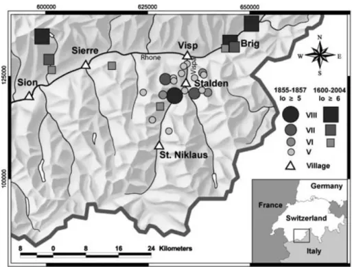
On 1855 July 25, a strong earthquake struck the region of the middle Valais and caused damage in a wide compass around Visp. In the Earthquake Catalogue of Switzerland (ECOS) (Swiss Seismological Service 2002; F¨ah et al. 2003), an epicentral intensity (Io) of 8 and an estimated moment magnitude (Mw) of 6.4 are assigned to this event. Dozens of aftershocks followed within the next months and years with Io up to 7 (Fig. 1 and Table 1). The epicentres of these events are supposed to be near the villages of Stalden and Visp.
The earthquake at Visp is one of several damaging events in Switzerland investigated within our project to reconstruct damage fields. Our main question is to what extent site effects and build-ing quality were responsible for these damages. For Switzerland this kind of research has twofold significance. First, Switzerland is situated in a zone of moderate seismic hazard: large, damaging earthquakes are rare but nevertheless possible (F¨ah et al. 2003). The last event that caused substantial damage occurred in 1964 in the central part of Switzerland (Gisler et al. 2004). Historical research is thus a very important way of dealing with damaging earthquakes in Switzerland. Many locations in Switzerland feature an inherent potential for site effects. Particularly the large Alpine valleys with their wide plains of large fluvial and lacustrine deposits show un-favourable soil conditions. Local amplifications of ground motion and non-linear effects are likely to occur in such areas during an earthquake. However, these naturally marshy plains have become
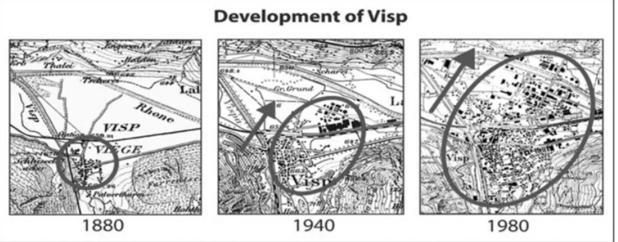
attractive places for expanded settlement in the last two centuries: river regulations allowed many villages and cities to grow exten-sively on these wide plains, as they do in the Rhine Valley or the Valais (Fig. 2). The risk to settlements is therefore increasing. Fur-ther research into the relation between damage and possible site effects is definitively merited.
Methods for answering the above-mentioned questions differ little in principle from approaches used for contemporary events. How-ever, all events investigated within this project occurred so long ago that additional and extensive historical investigation must pro-vide useful data. Here we concentrate on the historical part of the proceeding and reconstruct the damage field to accurately assign intensities for the 1855 event.
We will start with a short description of method followed by a dis-cussion and contextualization of the investigated historical sources. In subsequent paragraphs we focus on the damage and identify sec-ondary effects such as slope instabilities and rock fall. This will be done in two parts. After an overall description from a broad assem-blage of historical sources, we will concentrate on an extraordinary document: a set of contemporary and detailed lists describing the damage to the whole epicentral region. This evaluation was taken in the months after the mainshock at the behest of the government of the canton Valais. Given its unique completeness and consistency, it allows a quantitative analysis of the damage field. Then we discuss the problems of transforming historical information into computable data. The section ends with a discussion of results for the investigated
Figure 1. Historical seismicity of the investigated region in the middle Valais. Table 1. Main and aftershocks with Io≥ 5 (ECOS 2002).
Year Time Mw Io Ix 1855-07-25 11.50 am 6.4 8 8 07-26 09.15 am 5.6 7 8 07-26 01.20 pm 5.2 6 7 07-27 10.00 am 4.7 5 6 07-28 10.00 am 5.2 7 7 08-24 – 5.4 6 6 08-26 09.00 am 4.3 5 5 10-28 01.30 am 4.8 6 6 11-06 03.30 am 4.9 6 6 11-13 – 3.9 5 5 1856-01-05 02.50 am 3.9 5 5 02-09 06.13 am 3.9 5 – 08-06 01.45 pm 4.8 5 6 1857-11-04 07.15 am 4.3 5–6 – 11-14 03.30 am 3.9 5 – 1858-02-05 03.45 am 4.7 5 5 02-23 09.30 pm 3.9 5 – 04-06 02.30 am 3.9 5 – Mw: Moment magnitude. Io: Epicentral intensity. Ix: Maximum intensity.
damage. Its last paragraph takes a closer look at the village of Visp because it suffered the most severe loss during the earthquake series and represents special geological conditions. On the border of the Rhone-Valley plain, it has greatly expanded within the last century (Fig. 2). These factors encouraged an intensified historical inves-tigation which yielded the highest possible resolution of the Visp damage field.
2 A P P R O A C H A N D M E T H O D O L O G Y Our multidisciplinary approach combines methods originating in the science of history as well as seismology/geology. Generally
speak-ing, the first skills were used for data aggregation, while the latter were applied to data analysis.
Given the very informative and consistent written sources, it was possible to complete the historical investigation with high quality and plentiful results in the form of comparable data. While the con-temporary damage assessment in combination with statistical data were used for quantitative analysis, other sources were handled qual-itatively and used to calibrate the outcomes of the former analysis. This was mainly done by comparing damaged buildings specified in the contemporary damage assessment and other historical sources. Nevertheless, uncertainties and problems of interpretation remained and required care while assessing the damage. This final evaluation followed the guidelines of the European Macroseismic Scale 1998 (EMS 98) (Gr¨unthal 1998). It provides a set of tools to assess vulner-ability classes, damage grades and intensities. The data were handled in a conservative manner: whenever ambiguous descriptions had to be transformed into damage grades and intensities, the lower limit of this range was used. Assigning vulnerability classes was also done with caution. Then the reconstructed damage field was examined for patterns and distinctive features. After combining this informa-tion with geological data (particularly informainforma-tion about the surface geology and topography), we could detect locations that may have exhibited site effects. These identified locations were then subject to even more detailed investigation. Thus, we improved the resolution of these (local) damage fields by locating and assessing individual buildings that suffered damage. Of course, in many cases it was not possible to recover the accurate position of a building that had sus-tained damage. Nevertheless, the investigations were successful and provide very useful results for continuing studies, as the example of Visp will show.
3 T H E S O U R C E M AT E R I A L
The earthquake of Visp in 1855 is a well-known event for historical seismology in Switzerland. The event was felt not only all over the
Figure 2. Development of Visp from 1880 to 1980.
nation but also in other parts of Europe. The extent of damage was remarkable and is still unsurpassed in the Valais. The large quantity of available contemporary source material such as newspaper and scientific journal articles, travel diaries and entries in chronicles is, therefore, not surprising. Most known of these sources is the dairy of Pastor Moritz Tscheinen (1857). Tscheinen was an eyewitness living in T¨orbel, a small village in the epicentral area. With high accuracy, Tscheinen listed the series of main and aftershocks by notifying the date, time, strength and manner of the felt events (Table 1 and Fig. 1).
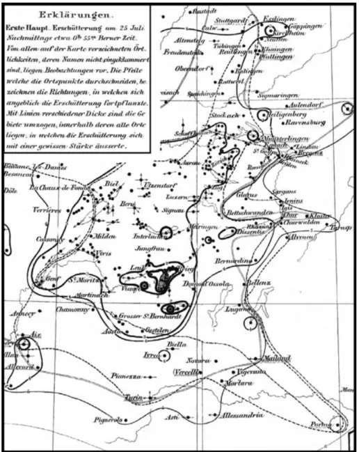
In a few cases he noted information about the damage. Another well-known and important source is the work of the German miner-alogist an geologist Otto Volger (Volger 1856). Volger (1822–1897) worked several years on historical earthquakes in Switzerland. A comprehensive publication in 1857 dealt with earthquake phenom-ena in Switzerland in general (Volger 1857), another publication with the 1855 earthquake in particular (Volger 1856). Remarkable for example is his ‘macroseismic map’ of the 1855 event: an early form of an isoseismic map (Fig. 3).
Also well known is a travel diary written by Johann Christian Heusser (Heusser 1856) with information on damage and secondary effects. Heusser visited the epicentral region in the second half of 1855 August. His report is very detailed and contains illustrations of an unknown artist (Figs 4 and 5).
Another travel diary, much less known but of utmost impor-tance, is entitled ‘Die Erdbeben im Visperthale’ (N¨oggerath 1855). N¨oggerath was Professor of mineralogy and mining at the Uni-versity of Bonn. Like Heusser, N¨oggerath provides a great deal of useful information about damaged buildings and other effects of the earthquake, sometimes in even more detail. This text was previously unknown to historical seismology and only found thanks to the hint of Bernhard Clemenz, a person interested in local history of the affected region. Finally a report by Walter de la Rive (De la Rive 1855) is worth mention. De la Rive accompanied a commission from Geneva founded to help the affected population. This commission visited the region about a month after the mainshock. The French ar-ticle gives an account of this journey and mentions many interesting details. In contrast to the above mentioned authors De la Rive is less interested in scientific insights. His report describes the earthquake more from the perspective of the affected population.
In addition to these published materials, we discovered an impor-tant source in the State Archive of the Canton Valais (Staatsarchiv Wallis, 27.3.3, 1855-156). It consists of lists assessing all buildings that sustained damage from the 1855 event. This source enables
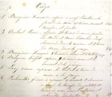
a quantitative analysis and thereby a precise reconstruction of the damage field. Immediately after the mainshock of 1855 July 25, the government of the State of Valais, domiciled in Sion, became aware of serious consequences. In its meeting of July 27, the gov-ernment decided to send a commission of experts into the affected region (Staatsarchiv Wallis 1101: Protocoles des s´eances du Conseil d’ ´Etat 1855-57, s´eance du 27. juillet 1855). This commission had orders to assess damage and consider reparations (Ibid.). During the following weeks, the commission members travelled from village to village to survey damage. Their descriptive lists usually consist of four columns and, depending on the extent of damage, up to 150 descriptions of cases of loss per township. The first column con-tains consecutive numbers, the second the name of the owner, the third a short description of the recognized damage and the fourth an estimation of the repair costs in Swiss Francs (Fig. 6).
In total we could identify 1800 cases of loss. The lists describe the damage to about 30 villages with a total population of approx. 11 000 residents (Statistisches Bureau des eidg. Departement des Innern 1862, 372-389). Today these townships have a total population of approx. 43 000 (Bundesamt f¨ur Statistik 2002).
4 A N O V E R A L L D E S C R I P T I O N O F T H E D A M A G E F I E L D
With the objective of calibrating the outcomes of the quantitative damage assessment, we considered results of a qualitative analy-sis based on sources other than the damage lists. The following chapter summarizes the most important observations of different eyewitnesses. In contrast to the damage lists, this material offers interesting information about secondary effects.
Johann J. N¨oggerath, a German geologist, reached the epicen-tral region travelling along the Rhone Valley from Lake Geneva via Sion. In Sion (approx. 50 km from the epicentre) he noted the first slight effects of the event: a few partly collapsed chimneys and some cracks in a couple of walls (N¨oggerath 1855, 7). However, soon after he left Sion, he became aware of more and more serious traces of the quake (App. I). In Sierre N¨oggerath noted ‘large cracks’ in walls and for Turtmann he writes of fairly heavily damaged buildings. ‘The post office has several cracks and the walls of the houses on the opposite side are several times cracked from the top to the bottom, particularly rifts in the edges of the perpendicularly connected walls were widely opened [. . .].’ (N¨oggerath 1855, ibid.) On September 9, N¨oggerath arrived in Visp, a village of about 130 houses. Several
Figure 3. Part of the isoseismic map of Volger with a scale from 1 (heavy destruction) to 6 (felt). (Volger 1856).
sources point out that the residents of this village left their houses for many days after the mainshock to live in tents on a meadow nearby (Staatsarchiv Wallis Fond famille Closuit: Lettre adress´e par le major Louis Closuit `a son ´epouse, 30. juillet 1855; N¨oggerath 1855, 18–19; Heusser 1856, 6). N¨oggerath estimated that more than half of the mostly multistory houses of Visp were built of stone. Like Heusser, who visited Visp earlier, N¨oggerath reported that all these stone buildings suffered damage: ‘[. . .] some collapsed imme-diately, others collapsed later or had to be broken away.’ (N¨oggerath 1855, ibid.). Heusser remarked that not a single stonewall was un-harmed in Visp: ‘[. . .] several [walls] are completely collapsed [. . .] of other walls sharply bounded pieces fell away [. . .] but all still ver-tical standing walls, I believe without an exception, are cleft from the bottom up.’ (Heusser 1856, 6). N¨oggerath finally gave account of buildings that suffered heavy damage to the roof: ‘One finds several houses with thrown off roofs consisting of very heavy and thick slates as well as wholly thrown off trusses [. . .].’ (N¨oggerath 1855, 13). According to both reports, wooden buildings sustained much less or even no damage, but the two churches of Visp suffered
heavy destruction. Both were large stone buildings. Martinskirche lost its famous pinnacle while the rest of the tower remained upright with many large cracks in the walls (Fig. 5). In both churches the well-constructed vaults (N¨oggerath 1855, 12) collapsed. N¨oggerath commented: ‘If already these structural collapses [the collapse of the vaults] require strong motion of the lateral walls, an even better proof [for this strong motion] is the fact, that in the Martinskirche the con-rods, tightening the lateral walls below the vault [. . .], partly broke, partly had been pulled out of the walls.’ (N¨oggerath 1855, ibid.). Heusser was particularly shocked by the heavy devastation inside the churches: ‘The walls of both churches are disrupted in many cases, and furthermore the interior of both of them form a veritable heap of rubble, as the organ, pieces of masonry and im-ages were all jumbled together.’ (Heusser 1856, 6). Both visitors also noted cracks in the ground of the village. Heusser gave an ac-count of a particularly large crack with a width ‘of about one half to one foot’ in the eastern part of Visp (Heusser 1856, 6). N¨oggerath mentioned several cracks in the alluvial ground in and near Visp (App. II). N¨oggerath as well as Heusser reported recent clefts in the
Figure 4. St. Niklaus after the mainshock of 1855 July 25 (Heusser 1856).
Figure 5. Visp and the Martinskirche with the damaged tower (Heusser
1856).
Figure 6. First page of the damage list of Visp. The columns contain from
the left to the right: consecutive numbers, the name of the owner, a short description of the damage and an amount of money in CHF. (Staatsarchiv Wallis 27.3.3: Ancien fonds du d´epartement de l’int´erieur. Tremblement de terre de juillet 1855. Revision de la taxe, distribution des secours.)
rock on which the western part of Visp is built (App. III). Just as re-markable are N¨oggerath’s observations concerning terrain changes in the ground surface: ‘For instance, I saw a [. . .] garden, that used to be completely even. Now it has wavelike elevations [. . .] with a level difference of about one to two feet.’ (N¨oggerath 1855, 14) What kind of ground deformation did he describe here? Does his de-scription indicate that the fault reached the surface near Visp or the presence of liquefaction? We don’t have enough information about this phenomenon to decide what happened exactly; unfortunately he gave no details about the location of this observation. However, fur-ther investigation showed that this phenomenon probably occurred on the northern periphery of Visp. A short note in the protocol of the government’s session of 1859 September 1, emphasizes strong secondary effects in these areas. The government discussed whether it should be forbidden to construct buildings on the plain of Visp for the future (Staatsarchiv Wallis 1101: Protocoles des s´eances du Conseil d’ ´Etat 1859). Although no such decision was taken, the dis-cussion shows how concerned the authorities must have been about certain effects in this area. Another report by E. Colombe belongs in the same category of observations. Colombe, a French scientist who visited Visp in October, wrote of flat farmland that subsided below the level of the Rhone river and became swampland (Colombe 1855, 953) (App. IV). Some hints in his description indicate that this effect occurred more or less in the same area as the ground deformation reported by N¨oggerath. However, a more difficult question to answer is the nature of the ground subsidence. A form of liquefaction must be considered, but other kinds of ground deformation are likely as well.
N¨oggerath as well as Heusser mentioned several locations in and near Visp where water leaked from the ground after the earthquake (N¨oggerath 1855, 15; Heusser 1856, 14) (App. V). According to Heusser, most of these sources became weaker shortly after the mainshock and ran dry in subsequent weeks (Ibid.).
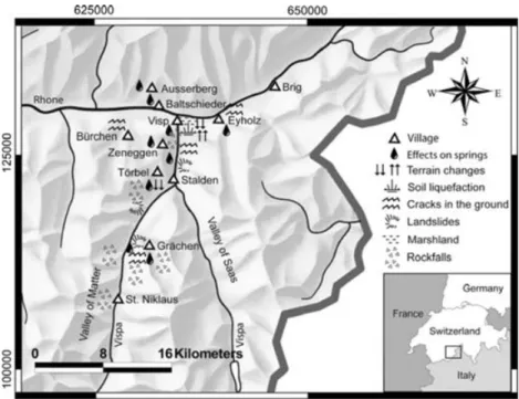
After their stays in Visp, Heusser as well as N¨oggerath travelled along mutual routes through the nearby villages for a couple of days (Fig. 1), Heusser in late September, N¨oggerath in October, they never met each other. Along the river of the Valley of Visp up to Stalden, St. Niklaus and Gr¨achen, both were constantly confronted by the effects of rock fall, landslides, cracks and rifts in the ground and newly emerged sources (Fig. 7). N¨oggerath particularly pointed out that ‘several times boulders of more than a thousand cubic foot’ plunged into the river (N¨oggerath 1855, 20). Near Stalden he recog-nized a landslide of ‘approximately 100 feet in width’ (N¨oggerath 1855, 21) (see Fig. 7). Heusser detected a broad system of rifts and cracks in the surface near Gr¨achen ‘that took him 2 hr to walk along’. (Heusser 1856, 11) (See Fig. 7). According to his report the rift was up to two feet wide and reached the bedrock, although the bedrock itself was not cracked. ‘. . . in contrast to the rock, the larches and spruces [growing above the crack] were cleaved up to a height of 8 feet.’ (Heusser 1856, 11).
Stalden is situated one-third of the way from Visp to St. Niklaus. N¨oggerath estimated the size of the former village to be about 70 buildings; half of them were farm buildings. He explained that the to-tal damage was proportionally smaller than in Visp because Sto-talden had more wooden buildings (N¨oggerath 1855, 20). However, the stone houses were ‘at least as much disrupted as in Visp; collapsed walls are nowhere missing [. . .] and the houses are partly not inhab-ited anymore.’ (Ibid.). In addition he remarked that ‘the church [. . .] and its tower is cleft in many cases, and the wall that separates the vault of the larger room of the church from the [vault of the] choir is collapsed.’ (Ibid.). Heusser’s report on Stalden agrees generally with N¨oggerath’s assessment.
Figure 7. Seismogeological effects in the Valley of Visp.
The next village they visited was St. Niklaus, a small spot of about 30 houses and 70 farm buildings. Like other authors describ-ing the damage to this village, N¨oggerath pointed out that the stone buildings suffered heavy destruction: ‘. . . all of them are either al-ready collapsed or disrupted in a way, that hardly one of them can be repaired.’ (N¨oggerath 1855, 24). While Heusser’s report con-tains no further information on St. Niklaus—with the exception of a meaningful illustration (Fig. 4)—Walter de la Rive’s description is remarkable. Similar to N¨oggerath and Heusser, De la Rive pointed out that damage is more apparent than in Visp or Stalden. ‘[. . .] there is no semi-devastation, the ruins are complete, the houses are not only disrupted but the debris covers the street [. . .] one of the hotels has quasi disappeared, its fa¸cades do not exist anymore [. . .].’ (De la Rive 1855, 95/96). However, if one believes De la Rive’s report, the disaster could have been much worse. According to him, the meadow above the village was littered with boulders of a rock fall stopped only by the soft soil. This circumstance protected the vil-lage from a catastrophe: ‘[. . .] if the terrain would have been frozen [. . .] nothing of St. Niklaus would have remained [. . .].’ (De la Rive 1855, 95/96) (Fig. 7).
For many other villages that suffered impact, the available infor-mation is much more fragmentary. This is because, on the one hand, damage to many of these villages was smaller and less spectacular, but on the other hand they also had lower publicity. Visp, Stalden and St. Niklaus are situated on the route to Zermatt, a village that already enjoyed a certain fame from tourism. For instance, several sources emphasize that Zermatt suffered no damage whereas other villages were not even mentioned where the aftermath of the earth-quake had been quite serious. The following list includes the most important fragments of information on some of these lesser known villages.
Gr¨achen: D. Lenoir reported that ‘[. . .] the vault of the church is disrupted [. . .]’ but the village in general suffered little because ‘all houses are built of wood [. . .]’ (Lenoir 1949, 129).
T¨orbel: The diary of Reverend Tscheinen described the heavy damaged church: ‘The vault of the church collapsed and threw
down the organ inclusive of the upper gallery [. . .].’ (Tscheinen 1857, 29).
Visperterminen: In his letter to the bishop, the pastor of Vis-perterminen describes the heavily damaged buildings owned by the church. Among them was the church itself, the charnel house, sev-eral chapels, the old rectory and the house of benefice (Archives Episcopales Sion) (App. VI).
Brig: Mentioning Brig briefly, N¨oggerath was surprised by the slight damage in this township given its comparatively small dis-tance from Visp. ‘Only many chimneys collapsed, some houses have cracks, and two turrets at the post station collapsed.’ (N¨oggerath 1855, 28).
This list could be continued but we have cited the most signifi-cant information. Let us consider instead the damage lists. These are, in contrast to the documents above, much more homoge-nous and offer completely different possibilities for describing the effects of the 1855 event. The next paragraph specifies the quantitative assessment and analysis we performed using these documents.
5 T H E Q UA N T I T AT I V E A N A LY S I S O F T H E D A M A G E L I S T S
Assumptions and conditions
A quantitative analysis of a damage field following EMS 98 con-sists of three steps. In the first step, observed damage to individ-ual buildings has to be divided into classes from grade 1 (negli-gible to slight damage) to grade 5 (destruction) (Gr¨unthal 1998, 15). The second step of a quantitative analysis consists of classify-ing the buildclassify-ings by their behaviour in an earthquake. Usclassify-ing four general types of structure (masonry, reinforced concrete, steel and wood) and several subdivisions, EMS 98 assigns to each a vul-nerability class describing susceptibility to damage. These range from class A (very vulnerable) to class F (very resistant) (Gr¨unthal 1998, 14). Including quantities (third step) in terms of ‘few’
(0–20 per cent), ‘many’ (10–60 per cent) and ‘most’ (50– 100 per cent) finally supplies the procedure with a statistical ele-ment (Gr¨unthal 1998, 17 and 25–26). Thus, the proportion of the individual damage grades as well as that of the different vulnerabil-ity classes gain quantitative values.
Merging the results from these three steps allows conclusions about a certain location: ‘many buildings of the vulnerability class b suffered damage of grade 3; a few of grade 4.’ (Gr¨unthal 1998, 17 and 25–26). A set of such conclusions finally allows us to assign intensities ranging from intensity I (not felt) to XII (completely devastating) (Gr¨unthal 1998, 15). Since our investi-gation relies only on data about damage, the results here will be intensity VI (slightly damaging) or higher (Gr¨unthal 1998, 15).
Our data stock contains information on about 1800 cases of loss, which could be assigned to several building types: houses, churches, barns, storehouses and mills. However, for two reasons the follow-ing analysis was done for houses only. First, the category is more homogenous than the others. Second, although the lists do not men-tion the number of damaged houses in contrast with the total number of existing stock, this category gap can be bridged through addi-tional sources. Data collections by the Swiss Confederation in 1860 (Statistisches Bureau des eidg. Departement des Innern 1862) con-tain useful and accurate information about the numbers of existing apartments and houses. Excluding all buildings other than houses, a dataset of 1074 records remained for further analysis. These records were then classified into groups of clearly identifiable geographical locations: the village mentioned in the header of the lists or parts of this village like a hamlet belonging to a certain township with a different location. With the exception of ‘Staldenried/Eisten’ (two villages located next to each other, for which the reports of loss were mixed up in the same list), the damage could be identified prop-erly and assigned to one of 31 definite locations. Map comparison showed that for all villages inside the affected region a damage list exists and that list is complete for all except the village of ‘T¨orbel.’ However, we learned that a single house was not necessarily charac-terized by only one entry in the lists of damage. This effect became visible when certain villages suddenly consisted of more damaged objects than houses. A large number houses obviously consisted of more than one apartment. We avoided the problem by shifting the main category from ‘houses’ to ‘apartments’. Although in the-ory this shift induced a slight bias to the intensities assigned later, the effect is negligible in practise for two reasons. First, the defini-tions used for quantities following EMS 98 (Gr¨unthal 1998, 17) are given as a wide interval not sensitive enough to perceive this effect. Second, the uncertainties in other factors, such as the assessment of vulnerability classes and damage grades, are far larger than this effect.
Other objections could be made about the time interval between the assessment of the damage cases in 1855/56 and the collection of the statistical data we used. About 75 per cent of the investi-gated townships could be correlated with data from the 1860 census (Statistisches Bureau 1862). For the remaining townships and ham-lets like Stalden, Neubr¨uck, Gamsen, Raron, Turtig, Rarnerchumma and St. German, adequate statistical data were not available before 1880 (Staatsarchiv Wallis Originaldokumente der Volksz¨ahlung, 1880). However, a look at the demographic development in the second half of the 19th century shows that the population and the number of houses and apartments did not change significantly (Bundesamt f¨ur Statistik 2002). Again, the effect is smaller than the uncertainties occurring during the EMS 98 procedure (Gr¨unthal 1998) described below.
Assigning damage grades
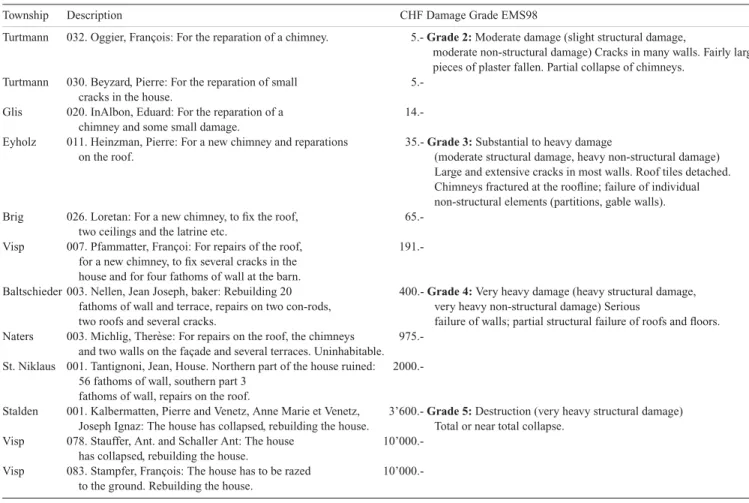
As mentioned in the formal description of the damage lists, this source describes cases of loss in a twofold way: first, as a short description in a few sentences and second as an amount of money in Swiss Francs. Both forms have their assets and drawbacks. In theory the description contains information about the kind of damage, while the amount of money helps to quantify the loss. However, in practice the descriptions are often difficult to interpret, while the amount of money depends not only on the quantity of loss but also on the workmanship and size of the object under reconstruction. A further problem concerns the value of Swiss currency in the 1850s. What quantum of work could have been done for a certain amount of money? To draw a direct comparison between prices then and now is, of course, not possible. However, taking a look at the wages of those days might lead to approximations. A worker in Zurich then earned, depending on his position, between CHF 1.20 and CHF 2.20 per day. (Gruner 1968, 123; Ritzmann-Blickenstorfer H. 1996).
If we take into account that the wages must have been lower in Valais because of the economic situation at that time, a fee in the range of CHF 0.80 and CHF 1.80 per day is conceivable for rebuild-ing. Even more difficult to estimate are the costs of the required ma-terials. A portion of 10–40 per cent of the total costs is only a rough guess. Even with such estimates, the annotated amount of money helps to quantify the historical losses. Another aid in interpreting the information within the damage lists came from the qualitative analysis. Many types of damage in the lists given in note form only could be identified in other, more detailed sources. In some cases a damaged building from the list could be correlated with a damage description in another source. Including such cross reference helped to reduce uncertainties substantially. Table 2 shows typical losses as given in the damage lists and their assigned damage grades.
Note that damage grade 1 is missing. In fact not a single case of loss could be assigned to this grade, although many had occurred in the investigated region. This distinctive gap occurs because dam-age of this category did not meet the criteria of loss qualifying for compensation payments. We assume that losses at the lower range of grade 2 had been skipped also. In general losses within damage grade 2 were easy to identify. In contrast, it was sometimes difficult to decide whether a building had suffered moderate structural dam-age (grade 3) or heavy (grade 4). Problematic cases were handled in a conservative manner.
Assigning Vulnerability Classes
An individual assessment of the buildings’ vulnerability classes was not feasible. Even for Visp, where many buildings of those days still exist, it was not possible to correlate all of them with the entries in the damage lists (see paragraph 6). We, therefore, assigned universally valid vulnerability classes on the basis of typical building types. In this the regional house specification done by Hunziker (Hunziker 1900–1914) proved very helpful. A reasonable classification for the region and period under study consists of the following building types:
1. Simple stone structure: This type was dominant in the city-like villages of Visp and Brig, and more often encountered in the villages near or at the bottom of the Rhone Valley than in the Valley of Visp or on the mountainside. They consisted of thick, mortar-strengthened walls and had up to five floors. The roofs were usually covered with heavy slates, or sometimes with large wooden shingles weighted down with stones or heavy wooden planks. According to EMS 98, this type of building fits in vulnerability class B with the
Table 2. Paraphrased extracts of damage lists. (Staatsarchiv Wallis 27.3.3: Ancien fonds du d´epartement de l’int´erieur. Tremblement de terre de juillet 1855.
Revision de la taxe, distribution des secours.)
Township Description CHF Damage Grade EMS98
Turtmann 032. Oggier, Fran¸cois: For the reparation of a chimney. 5.- Grade 2: Moderate damage (slight structural damage,
moderate non-structural damage) Cracks in many walls. Fairly large pieces of plaster fallen. Partial collapse of chimneys.
Turtmann 030. Beyzard, Pierre: For the reparation of small 5.-cracks in the house.
Glis 020. InAlbon, Eduard: For the reparation of a 14.-chimney and some small damage.
Eyholz 011. Heinzman, Pierre: For a new chimney and reparations 35.- Grade 3: Substantial to heavy damage
on the roof. (moderate structural damage, heavy non-structural damage) Large and extensive cracks in most walls. Roof tiles detached. Chimneys fractured at the roofline; failure of individual non-structural elements (partitions, gable walls). Brig 026. Loretan: For a new chimney, to fix the roof,
65.-two ceilings and the latrine etc.
Visp 007. Pfammatter, Fran¸coi: For repairs of the roof, 191.-for a new chimney, to fix several cracks in the
house and for four fathoms of wall at the barn.
Baltschieder 003. Nellen, Jean Joseph, baker: Rebuilding 20 400.- Grade 4: Very heavy damage (heavy structural damage, fathoms of wall and terrace, repairs on two con-rods, very heavy non-structural damage) Serious
two roofs and several cracks. failure of walls; partial structural failure of roofs and floors. Naters 003. Michlig, Ther`ese: For repairs on the roof, the chimneys
975.-and two walls on the fa¸cade 975.-and several terraces. Uninhabitable. St. Niklaus 001. Tantignoni, Jean, House. Northern part of the house ruined:
2000.-56 fathoms of wall, southern part 3 fathoms of wall, repairs on the roof.
Stalden 001. Kalbermatten, Pierre and Venetz, Anne Marie et Venetz, 3’600.- Grade 5: Destruction (very heavy structural damage) Joseph Ignaz: The house has collapsed, rebuilding the house. Total or near total collapse.
Visp 078. Stauffer, Ant. and Schaller Ant: The house 10’000.-has collapsed, rebuilding the house.
Visp 083. Stampfer, Fran¸cois: The house has to be razed 10’000.-to the ground. Rebuilding the house.
possibility of some buildings belonging to class A, depending on their condition and quality.
2. Timber structure: Wooden houses were common in the villages of the upper valley of Visp and on the mountainside in general. They usually rested on a small groundwork of simple stone masonry and were constructed as blockhouses with up to four floors. This type of structure is similar to that of a log-house, with the difference that timber is used. Like the simple stone houses, their roofs were either covered with heavy slates or large, weighted wooden shingles. EMS 98 classifies wooden structures in the range between B and E, with the main focus on D. A blockhouse structure is basically very resistant. The weak point of these houses is their roof. When covered with slates, they are very heavy and thus vulnerable. When covered with shingles, the insufficient stability becomes a problem. Therefore, we assigned this type of building to vulnerability class C.
3. Combined simple stone/timber structures: Basically this type is a mixture of the two first building types. It was probably the most common structure in those days and existed throughout the investigated region. Usually the walls were built of simple stone masonry up to the first floor, and rarely up to the second floor (Hunziker 1900–1914, 222). The upper part of these three-to-four storey houses, including the roof construction, shows the same ar-chitecture as the pure timber construction. EMS 98 doesn’t mention a comparable building type. However, vulnerability class B is prob-ably the most appropriate estimate.
Results from qualitative analysis were also included at this level of data interpretation. Many of the respective sources contain
im-portant information concerning the building stock (simple stone structures/timber structures). Furthermore, we analysed old pho-tographs and illustrations from (Hunziker 1900–1914; Fux 1996). We conclude that the distribution of vulnerability classes was about as follows. Three-quarters of the existing houses belonged to vulner-ability class B, including a few structures of class A for buildings in very bad condition. Another quarter belonged to vulnerability class C, with a few buildings in class D for extraordinarily well-built timber constructions. We will discuss the uncertainties of this assumption and its possible impact on the resulting intensity de-grees in the next paragraph. With the exception of the houses in the city-like villages of Visp and Brig, the majority of the houses had a regular ground plan and were freestanding.
Assigning quantities
Our results show that the damage fields of the villages in the main valley were dominated by damaged buildings of vulnerability class B that suffered damage of grade 3 (with the exception of Visp which suffered damage grade 4). Likewise, most villages near the Vispa River (Neubr¨uck, Stalden, St. Niklaus) and those on the western mountainside of Visp (Zeneggen, B¨urchen, Unterb¨ach und Eischoll) showed a similar pattern. To the west the proportion of damage grade 2 for buildings of vulnerability class B increased. In contrast to these locations, most other villages on the mountainside consisted of a higher proportion of timber structures belonging to vulnerability class C. Thus, damage fields of these locations exhibited damage grade 3 to buildings of vulnerability class B and C. The absence of
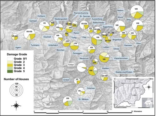
Figure 8. Damage grades and intensities assigned on the basis of the damage lists. For locations with intensity degrees in the form of VII–VIII, it was not
possible to decide which value is appropriate. They contain elements of intensity degrees VII and VIII. (Gr¨unthal 1998, p. 57).
damage grade 4 in the villages Gr¨achen, Embd, Staldenried, Eisten, Ausserberg, Rarnerchumma and Hohtenn has to be seen in part as the effect of better building stock.
Results: distribution of damage and intensity degrees
Fig. 8 summarizes the results of the assessed damage field on the background of a reproduced map (1:100 000) first published in 1854 (Bundesamt f¨ur Landestopographie 1988). The investigated regions are plotted as pie charts. Their size is proportional to the total num-ber of existing houses at that time. The coloured segments indi-cate the different damage grades. As mentioned, damage of levels 1 and some of 2 were not assessed and are, therefore, included in the white coloured segment representing the undamaged buildings. The assigned intensity degrees are represented by roman numerals. Before going into detail. we will compare this figure with the de-scriptions and comments in paragraph 4 (an overall description of the damage field pp. 11–17). Two differences are obvious. While the highest intensities in Fig. 8 are of grade VIII (heavily damaging), an assignment of intensities on the basis of the quotations in paragraph 4 would instead produce intensities of up to grade IX (destructive). On the other hand, the geographic range containing assured infor-mation about losses in this paragraph is much smaller than shown in Fig. 8. These are typical phenomena in the context of historical data: historical documents often address a broader public focus in considering the most remarkable or newsworthy effects of an earth-quake (Gr¨unthal 1998, 52), particularly if the society believes the
consequences of the event as catastrophic. Sources of that type pose the danger of overestimated intensities. In contrast, less spectacu-lar effects tend to be passed over and can lead to underestimating the geographical dispersion of the effects. This phenomenon is of-ten heighof-tened by the relative anonymity of most villages in an epicentral-region compared to a few better known locations, partic-ularly cities. In our case the villages situated in the Valley of Visp were much better known than others. A historical source like the one forming the basis of the quantitative analysis (the damage lists) runs fewer of these risks since its aim was comparable to ours. In general a correlation between the historical information provided in paragraph 4 and Fig. 8 is clear: the extent of loss increases along the main valley from Agarn via Raron to Visp, where approx. 25 per cent of homes suffered damage grade 4 and a few buildings col-lapsed totally. The same is true for the Valley of Visp. Stalden and St. Niklaus suffered most with widespread grade 4 damage, while Gr¨achen was much less affected.
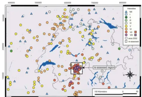
After a closer look at Fig. 8, the following deserves attention. According to EMS 98 damage occurs in the range of intensity VI and higher (Gr¨unthal 1998, 18–20). However, our damage field shows no intensities of degree VI, not even on its borders. This is due to the fact that intensity VI is defined by damage of grades 1 and 2, which did not (or only partly) match the criteria to obtain compensation payments. Thus, we have to assume that outside the figure border localities showing intensities of degree VI were present in 1855. Fig. 9 is based on several earthquake catalogues and confirms this assumption, showing the investigated region as part of the entire macroseismic field.
Figure 9. Investigated region as part of the entire macroseismic field of 1855. The data for this analysis derive from the revised Earthquake Catalogue of
Switzerland (ECOS) (Swiss Seismological Service 2002), from the Italian Catalogo parametrico dei terremoti italiani (Istituto Nazionale di Geofisica 2005) and from the French catalogue SisFrance (BRGM et al. 2005).
Another distinctive feature is the dispersion of localities with the highest extent of damage grade 4: near or higher than 25 per cent. While the villages of Visp and Stalden are located in the centre, we find Naters and St. Niklaus on the periphery of the damage field. Furthermore all these villages are in the immediate vicinity of others that show a clearly lower intensity with no significantly different building stocks. Both observations suggest that local site effects could have played a role in the emerging damage pattern. To verify this assumption, we must first produce a higher-resolution assessment of the local damage fields of these villages and then perform geologic and seismic investigation. In this paper we will enact the first step in a case study on Visp and present the results of our historical investigations.
The general nature of the damage field suggests that the respon-sible fault is close to the surface. The geological structure indicates that the mechanism is a normal fault, striking along the Valley of Visp (north south) and dipping to the west (Crealp 1999). This as-sumption is supported by C. L. Joris, who observed a neo-tectonic fault approximately 2 km southeast of Visp on the eastern slope of the Valais of Visp. This fault was also visible during construction work on a tunnel (Joris 2005, personal communication and field visit). Such a fault would explain the macroseismic field shown in Fig. 9. The intensities in the west of the source (hanging wall) are clearly higher than in the east (foot wall). Finally, the heavy damage in Visp as well as the non-linear effects to its northeast would support the thesis of this fault’s responsibility for the 1855 event. Unfortunately detailed studies of this topic have not yet been carried out.
6 V I S P A F T E R T H E E A RT H Q UA K E I N 1 8 5 5
According to the census of 1860, Visp then consisted of 78 houses and had a total population of 623 inhabitants living in 129 apartments (Statistisches Bureau des eidg. Departement des Innern 1862, 368). A large part of this historical old town still exists and differs little from the 1850s. This fact allowed us to locate many of the buildings damaged in 1855. For some others no longer existing, it was
possi-ble to identify their former position. We were apossi-ble to locate exactly about 50 per cent of the houses mentioned in the damage lists. Ap-proximately 20 per cent could be assigned to one of three parts of the township (see Fig. 10). This detective work was based upon compar-ing the damage lists to the original documents of the 1850 population census (Eidgen¨ossische Volksz¨ahlung 1850, Gemeinde Visp) and 1870 (Eidgen¨ossische Volksz¨ahlung 1870, Gemeinde Visp). How-ever, even more important than these documents was the help of the local historian, Christian Fux. His profound knowledge of Visp, its history, and families was indispensable to the completion of this work.
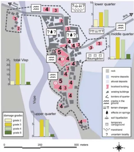
Fig. 10 summarizes the results of this historical investigation against the geological background. Exactly located buildings are marked in red. The corresponding number specifies the assigned damage grade. In contrast to this, the black coloured houses do not represent the exact situation as it was in the 1850s, but indicate the area of the historical village. The dotted line represents the borders of the historical quarters, as they could be reproduced on the basis of the 1870 census documents. Finally, the bar charts summarize the damage per quarter including that to houses whose location is not exact. All the still existing houses are built in simple stone masonry and belong to vulnerability class B. We assume as well that most buildings no longer existing fit into this category. Indications for this assumption can be found in the photograph of Visp (Fig. 11) published by Fux (1996).
The bar charts show that the distribution of damage grades is very similar in all three parts of Visp. This is astonishing when we consider that the geological situations of the upper quarter (built on rock) and the lower (built on the large deposits of the main val-ley) differ significantly. Because of amplification effects, we had expected that more serious damage would have occurred on the de-posits than on the rock. The assumption that a site effect played a major role in the damage distribution in Visp is thus not yet verifi-able. A possible explanation for the equal distribution of the damage is a source effect. This thesis would agree with the fault postulated by (Crealp 1999) and Joris (2005). However, to understand better what really happened in the Visp of 1855, we plan to further investigate
Figure 10. Geology, localized buildings, dispersion of damage and approximate position of seismogeological effects in Visp.
the local geology and perform extended seismological recordings. For the above-mentioned townships showing analogue potential for site effects (Stalden, St. Niklaus and Naters), similar considerations should be taken into account.
7 C O N C L U S I O N
To better understand the damage fields of historical earthquakes, we investigated the consequences of the 1855 earthquake in the region of Visp. Since this event is very well documented by contemporary sources, it was possible to reconstruct the damage field with unusual accuracy and an adequate resolution. Published sources on the one hand and a damage evaluation done on the behest of the cantonal government on the other allowed a combination of two different approaches. While the damage lists were used for a quantitative analysis, the information from the other sources enabled qualitative description of the damage field. Both analyses were done following the guidelines of EMS 98. Comparing the analyses showed in general similar outcomes, but interesting differences in the details. It became obvious that sources addressing a broader public often overestimate particular cases of loss, but underestimate the geographic range of a disaster. This example points out again the importance of treat-ing information based on historical sources with care. In contrast, data from the damage lists are much more consistent and complete. Given the purpose of these latter documents, their information fits our scientific interest very well. The intensities presented here were assigned after quantitative analysis of these damage lists and with additional information from census documents contemporary with the event. These intensities fall in the range of 7 to 8. The absence of intensity 6 is explainable since damage of grade 1 did not match the government’s criteria for financial support. A comparison of all investigated localities shows that the townships of Visp, Stalden, St. Niklaus and Naters suffered most, with remarkable extent of grade 4 damage. Their irregular geographic arrangement and the fact that all these townships are near locations showing much lower intensities suggest that this pattern results from site effects. The more detailed historical investigation of the damage field of Visp was successful in that we located about 50 per cent of the houses damaged in 1855. Although the ground beneath Visp consists of very different zones of rock and alluvial deposits, the damage was evenly distributed. A site effect was not identifiable. A possible explanation for this con-sistent distribution was found in the observation that source effects could have dominated ground motion near Visp. We plan further investigations in Visp and other villages, focusing on their local geological conditions and subsurface fundamental frequencies. A C K N O W L E D G M E N T S
This paper was prepared while working for a PhD project at the Swiss Federal Institute of Technology in Zurich. We would like to thank all who contributed. Special thanks go to Christian Fux and to the staff of the archive of the Canton Valais for their helpful contributions to the historical part of our work. We also thank Charles-Louis Joris for his expertise on the geology of the region and to our English ed-itor Dr. Kathleen J. Jackson. Finally, we gratefully acknowledge the financial support of the Swiss National Science Foundation (project number: 205121-100510).
R E F E R E N C E S Historical Sources
Archives Episcopales Sion. T. 067 No. 030 Brief von P.J. Studer, Pfarrer in Visperterminen an den Bischof von Sion, 1. August, 1855.
Colombe, E., 1855. Tremblement de Terre du Valais. Comptes rendus heb-domadairtes des s´eances de l’academie des scieces, Paris, Vol. 39: 952– 954.
Comit´e Central de Bienfaisance, 1860. Rapport du Comit´e Central de Bien-faisance, charg´e de la r´epartition des secours recueillis pour les victimes du tremblement du terre qui a d´evast´e en 1855 les distrites du Rarogne, de Brique et de Vi`ege. Sion.
De la Rive, W., 1855. Une excursion en Valais. Bibliotheque universelle de Gen`eve, 30: S. 78–102.
Heusser, J.C., 1856. Das Erdbeben im Visper-Thal im Jahr 1855. An die z¨urcherische Jungend auf deas Jahr 1856. Neujahrsbl¨atter der Natur-forschenden Gesellschaft, Vol. 58.
Lenoir, D., 1949. R´ecit du tremblement de terre du Valais (25 juillet 1855) ´ecrit par David Lenoir. Bulletin de la Murithienne Fasc., 66.
N¨oggerath, J., 1855. Die Erdbeben im Vispthale. Besonderer Abdruck f¨ur Freunde des Verfassers aus Nr. 282 bis 286 der K¨olnischen Zeitung von 1855. K¨oln, Selbstverlag.
Staatsarchiv Wallis. 27.3.2: Ancien fonds du d´epartement de l’int´erieur. Tremblement de terre de juillet 1855. Expertises des dommages. Staatsarchiv Wallis. 27.3.3: Ancien fonds du d´epartement de l’int´erieur.
Tremblement de terre de juillet 1855. Revision de la taxe, distribution des secours.
Staatsarchiv Wallis. 1101: Protocoles des s´eances du Conseil d’ ´Etat 1855– 57.
Staatsarchiv Wallis. Fond famille Closuit: Lettre adress´e par le major Louis Closuit `a son ´epouse, 30. juillet 1855.
Statistisches Bureau des eidg. Departement des Innern, Ed., 1862. Schweiz-erische Statistik. Bev¨olkerung. Eidgen¨ossische Volksz¨ahlung vom 10. De-cember 1860. Bern.
Tscheinen, M., 1857. Tagebuch ¨uber die Erdbeben des Visperthales in den Jahren 1855 und 1856 von Hrn. Pfarrer Tscheinen in T¨orbel. Viertel-jahrsschrift der Naturforschenden Gesellschaft in Z¨urich 2. Jahrgang. Volger, O.G.H., 1856. Untersuchungen ¨uber das letztj¨ahrige Erdbeben in
Central-Europa. Mittheilungen aus Justus Perthes’ geographischer Anstalt ¨uber wichtige neue Erforschungen auf dem Gesammtgebiete der Geogra-phie. Von Dr. A. Petermann: 12–100.
Volger, O.G.H., 1857. Untersuchungen ¨uber das Ph¨anomen der Erdbeben in der Schweiz, 3Teile. Gotha.
Scientific Literature
BRGM, EDF and IRSN, 2005. SisFrance. http://www.sisfrance.net. Bundesamt f¨ur Landestopographie, 1988. Topographische Karte der
Schweiz 1:100 000. Vermessen und herausgegeben auf Befehl der eidgen¨ossischen Beh¨orden/aufgenommen und reduziert durch eid-gen¨ossische Ingenieure unter Aufsicht des Generals G. H. Dufour, 1833– 1863. Nachdruck. Blatt XVIII, first edition 1854. Wabern.
Bundesamt f¨ur Statistik, Ed., 2002. Bev¨olkerungsentwicklung der Gemein-den 1850–2000. Eidgen¨ossische Volksz¨ahlung 2000. Autoren: Martin Schuler Dominik Ullmann, Werner Haug. Neuchˆatel, Bundesamt f¨ur Statistik.
Crealp, 1999. Blocs diagrammes pr´esantant les contextes structureaux des s´eismes de ‘Vi`ege’ 1855 et de ‘Sierre’ 1946. By M. Sartory. http://www.crealp.ch/f˙principal.html.
F¨ah, D., Gardini, D. et al., 2003. Earthquake Cataloque of Switzerland (ECOS) and the related macroseismic database. Eclogae geol. Helv. 96. Fux, C., 1996. Erinnern Sie sich. Visp. Visp, Rotten.
Gisler, M., F¨ah, D. & K¨astli, P., 2004. Historical seismicity in Central Switzerland. Eclogae geol. Helv. 97.
Gruner, E., 1968. Die Arbeiter in der Schweiz im 19. Jahrhundert. Soziale Lage, Organisation, Verh¨altnis zu Arbeitgeber und Staat. Bern, Franke. Gr¨unthal, G., 1998. European Macroseismic Scale 1998. Cahiers du Centre
Europ´een de Geodynamics et de S´eismologie 15.
Hunziker, J., 1900–1914. Das Schweizer Haus nach seinen landschaftlichen Formen und seiner geschichtlichen Entwicklung. Erster Abschnitt: Das Wallis (1900). Aarau, Sauerl¨ander.
Istituto Nazionale di Geofisica, 2005. Catalogo parametrico dei terremoti italiani (NT 4.1.1). http://emidius.mi.ingv.it/DOM/home.html. Joris, C.-L., 2005. Neotectonic fault in the south east of Visp. Personal
Ritzmann-Blickenstorfer, H., Ed., 1996. Historische Statistik der Schweiz/unter der Leitung von Hansj¨org Siegenthaler. Z¨urich, Chronos. Swiss Seismological Service, 2002. ECOS—Earthquake Cataloque of
Switzerland, http://www.seismo.ethz.ch.
A P P E N D I X : Q U O T AT I O N S O F E Y E W I T N E S S E S
App. I (N¨oggerath 1855): ‘In Sion the traces of the earthquake were small; a few chimneys were collapsed, some walls had cracks and in several rooms the bell rang. [. . .] The first serious cracks in walls occurred in Sierre; I haven’t seen them myself.
App. II (N¨oggerath 1855): ‘They run rather parallel to each other through the ground, and continue even through walls of gardens. There are many of this kind of cracks, especially near the bridge crossing the Vispa [River. . .].’
App. III (Heusser 1856, 15)‘Finally I must not forget to mention that the rock, on which the church is built, is cracked. [. . .] The opening [of the crack] had a width of one half to one foot when I saw it [. . .].’
(N¨oggerath 1855): ‘[. . .] in the massive schist occurred numerous vertical cracks. These cracks are a little opened only, but
unmistak-ably new and easy to distinguish from older clefts because of the fresh fracture.’
App. IV (Colombe 1855, 953): ‘[. . .] the earthquakes resulted in a clear subsidence of flat terrains in the bottom of the valley, below the level of the Rhone, in a manner that excellent farmland [. . .] is overflowed today and turned into swampland.’
App. V (N¨oggerath, 1855, 15): ‘During the earthquakes and even much later water poured out of these [cracks] [. . .]; step by step the sources stopped and the cracks disappeared. In Visp itself many of these sources still exist. They even sputter inside a few destroyed houses [. . .].’
App. VI (Archives Episcopales Sion): ‘The spire of the pin-nacle is broken away, the church itself [. . .] because of the many cracks is heavy damaged. The vault of the ‘Gnadenkapelle’ is col-lapsed [. . .], all shrines are mauled, the ossuary apart six other chapels [. . .] is partly smashed, partly otherwise in very poor condition. The old rectory [. . .] is uninhabitable in one half, the house of benefice [Pfrundhaus] has a damaged roof and several cracks; [. . .].’ The Gnadenkapelle (Chapel of Mercy) is proba-bly the only remaining testimonial of the disaster in 1855. The chapel was neither knocked down nor repaired. Their ruins still exist today.