HAL Id: tel-01252831
https://tel.archives-ouvertes.fr/tel-01252831
Submitted on 15 Jan 2016HAL is a multi-disciplinary open access archive for the deposit and dissemination of sci-entific research documents, whether they are pub-lished or not. The documents may come from teaching and research institutions in France or abroad, or from public or private research centers.
L’archive ouverte pluridisciplinaire HAL, est destinée au dépôt et à la diffusion de documents scientifiques de niveau recherche, publiés ou non, émanant des établissements d’enseignement et de recherche français ou étrangers, des laboratoires publics ou privés.
Towards Unsupervised And Incremental Semantic
Mapping
Guillaume Duceux
To cite this version:
Guillaume Duceux. Towards Unsupervised And Incremental Semantic Mapping . Robotics [cs.RO]. ENSTA ParisTech, 2015. English. �tel-01252831�
Towards Unsupervised And Incremental
Semantic Mapping
Th`ese pr´esent´ee par
Guillaume Dominique Duceux
`
a l’Unit´e Informatique et Ing´enierie des Syst`emes pour l’obtention du grade de Docteur de
l’ENSTA ParisTech Sp´ecialit´e : Informatique
Th`ese soutenue le 27 Novembre 2015
devant le jury compos´e de
rapporteurs: Simon Lacroix CNRS
Olivier Aycard University of Grenoble 1 Paul Checchin Institut Pascal
examinateurs: Patrick Rives INRIA
Eric Moline DGA
directeur de th`ese: David Filliat ENSTA-ParisTech
U2IS, ENSTA-ParisTech Palaiseau, France January 15, 2016
Abstract
Robots are slowly entering our houses. But for them to perform more difficult and interesting tasks, they need to have a richer knowledge of the different objects and places present in a particular household. Building and using such a complex knowledge is called semantic mapping and navigation, which requires many different capabilities such as mapping, localization and object recognition. Most of them have been thoroughly studied in the past but often separately and in a different context. We propose a complete solution to perform incremental and unsupervised semantic mapping working on a real robot. Each aspect of the solution is discussed from the software architecture to all the functionalities needed by the robot. Some already existing techniques have been derived in the effort of integration, but more importantly three different parts of the solution are original contributions. The first one is the use of 2D laser range finder to perform object recognition using multiple views of the objects. Numerous semantic mapping solutions are using this sensor for mapping and obstacle avoidance, but we fully leveraged it by developing techniques to use it in the entire process of semantic mapping, showing that it is effective at recognizing up to 20 different objects in an indoor scenario. Secondly we introduce the graph-of-views object modeling method. In our effort to extend bag-of-views techniques to perform multi-modal modeling of objects we derived an original formulation which is more adapted to partial perception of objects. We applied this approach to object recognition using both a laser range finder and a RGB-D camera, showing that it is able to take advantage of both sensor strengths. Finally, while most existing semantic mapping techniques rely on supervised learning of objects, we present an original incremental and unsupervised learning algorithm. Our technique was applied to the learning of multi-modal models of dynamic objects that are encountered as the robot navigate an indoor environment for an extended period of time, showing that it is able to produce consistent models of these objects without human intervention.
R´
esum´
e
Les robots entrent peu `a peu dans nos maisons. Mais pour r´ealiser des tˆaches plus difficiles et int´eressantes, ils doivent poss´eder une connaissance riche des diff´erents objets et lieux pr´esent dans une habitation particuli`ere. Constru-ire et utiliser une telle connaissance s’appelle la cartographie et navigation s´emantique et n´ecessite de nombreuses capacit´es comme la cartographie, la localisation ou encore la reconnaissance d’objets. La plupart de celles-ci ont ´et´e longuement ´etudi´ees dans le pass´e mais souvent s´epar´ement et dans un contexte diff´erent. Nous proposons une solution compl`ete fonction-nant sur un robot capable d’effectuer progressivement et sans supervision la cartographie s´emantique d’un lieu. Chaque aspect de cette solution est examin´e depuis l’architecture logicielle jusqu’aux fonctionnalit´es requises par le robot. Certaines techniques d´ej`a existantes ont ´et´e adapt´ees dans l’effort d’int´egration et trois parties diff´erentes de la solution sont des contributions originales. La premi`ere est l’utilisation de la t´el´em´etrie laser 2D pour effectuer la reconnaissance d’objets en utilisant des vues multiples des objets. De nombreuses solutions de cartographie s´emantiques utilisent ce capteur pour la cartographie et l’´evitement d’obstacle, mais nous en avons pleinement tir´e profit en d´eveloppant des techniques pour l’utiliser dans l’ensemble du processus de cartographie s´emantique, montrant qu’il est efficace pour recon-naˆıtre jusqu’`a 20 objets diff´erents dans un sc´enario d’environnement int´erieur. Deuxi`emement, nous pr´esentons une m´ethode de mod´elisation d’objets par graphes de vues. Dans notre effort pour ´etendre les techniques de sac-de-vues pour effectuer la mod´elisation multi-modale des objets, nous avons d´evelopp´e une formulation originale qui est plus adapt´e `a la perception partielle des objets. Nous avons appliqu´e cette approche `a la reconnaissance d’objets en utilisant `a la fois un t´el´em`etre laser et une cam´era RGB-D, montrant qu’elle est en mesure de tirer avantage des points forts des deux capteurs. Enfin, alors que la plupart des techniques s´emantiques de cartographie ex-istantes reposent sur l’apprentissage supervis´e des objets, nous pr´esentons un algorithme d’apprentissage incr´emental et non supervis´e original. Notre technique a ´et´e appliqu´ee `a l’apprentissage de mod`eles multi-modaux des ob-jets dynamiques pr´esents dans un environnement int´erieur pour une p´eriode de temps prolong´ee, montrant qu’elle est capable de produire des mod`eles coh´erents de ces objets sans intervention humaine.
Contents
Abstract iii
R´esum´e v
1 Introduction 1
1.1 Context: Semantic navigation . . . 1
1.2 Target application . . . 3 1.3 Related work . . . 4 1.4 Contribution summary . . . 6 1.5 Outline . . . 7 2 Background 9 2.1 Introduction. . . 9
2.2 Environment representation, robot localization and mapping 10 2.3 Obstacle avoidance and path planning . . . 13
2.4 Moving object tracking. . . 15
2.5 Object detection, segmentation and discovery . . . 16
2.6 Object modeling and recognition . . . 18
2.7 Semantic mapping . . . 19
2.8 Robot architecture . . . 22
2.9 Conclusion . . . 24
3 Robot architecture for semantic navigation 27 3.1 Introduction. . . 27
3.2 Hardware . . . 28
3.3 Participation to the Defi CAROTTE . . . 29
3.3.1 Software Architecture . . . 29
3.3.2 RGB-D object segmentation and recognition . . . 32
3.3.3 Exploration target and multi-modal path planning . . 33
3.3.4 Limitations of the architecture . . . 36
3.4 Unsupervised and incremental semantic mapping . . . 36
3.4.1 Software Architecture . . . 36
3.4.2 Incremental static occupancy grid . . . 37
CONTENTS
3.4.4 Laser readings segmentation. . . 42
3.4.5 Object Tracking . . . 43
3.4.6 Object modeling, recognition and learning . . . 43
3.5 Experimental results . . . 44
3.5.1 D´efi CAROTTE . . . 45
3.5.2 Unsupervised Semantic Mapping . . . 46
3.6 Discussion and Conclusion . . . 49
4 Object recognition using laser range finder 51 4.1 Introduction. . . 51
4.2 Related work . . . 52
4.3 Contribution . . . 53
4.3.1 Pair of points based descriptor . . . 53
4.3.2 Triangle based descriptor . . . 54
4.3.3 Descriptor clustering . . . 56
4.3.4 Object modeling . . . 56
4.4 Experimental results . . . 57
4.4.1 Pair of points based laser descriptor evaluation (PPLD) 58 4.4.2 Recognition with complete models using the PPLD . . 59
4.4.3 Recognition with partial models using the PPLD . . . 60
4.4.4 Triangle based laser descriptor evaluation (TLD) . . . 61
4.4.5 Recognition with complete models using the TLD . . 62
4.5 Conclusion . . . 64
5 Multi-modal object modeling 65 5.1 Introduction. . . 65
5.2 Related work . . . 66
5.3 Graph-of-view object model . . . 68
5.3.1 Representation . . . 68
5.3.2 Definition . . . 71
5.3.3 Comparison one to one . . . 71
5.3.4 Comparison one to many . . . 74
5.4 Experimental results . . . 76
5.4.1 Dataset . . . 76
5.4.2 Graph-of-Views versus Bag-of-Views . . . 78
5.4.3 Modalities contributions . . . 80
5.4.4 Comparison of different similarity measures . . . 83
5.4.5 Merging study . . . 85
5.5 Conclusion . . . 86
6 Unsupervised and incremental object learning 87 6.1 Introduction. . . 87
6.2 Related work . . . 88
6.3 Unsupervised object learning . . . 89 viii
0.0
6.3.1 Classification . . . 90
6.3.2 Sequential Clustering Algorithms . . . 91
6.3.3 Graph clustering approach . . . 93
6.4 Experimental results . . . 101
6.4.1 Sequential clustering on Bag-of-views using the PPLD descriptor . . . 101
6.4.2 Graph clustering on multi-modal Graph-of-views . . . 104
6.4.3 Comparison of sequential and graph clusterings . . . . 110
6.5 Conclusion . . . 113
7 Discussion, future work and conclusion 115 7.1 Long term semantic mapping and navigation . . . 115
7.2 Fast saliency and prior recognition . . . 116
7.3 Robustness to appearance variations and ill perception . . . . 118
7.4 Unsupervised and incremental objects learning . . . 120
Chapter 1
Introduction
1.1
Context: Semantic navigation
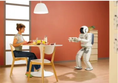
Figure 1.1: The robot Asimo bringing coffee to the table in a house. It illustrates how having a robot butler could look like.
We had long dreamed of building or having a robot butler. It would be fantastic to have one or more robots in our houses to take care of all the household chores. This kind of robots is referred to as domestic robots or personal service robots (fig.1.1).
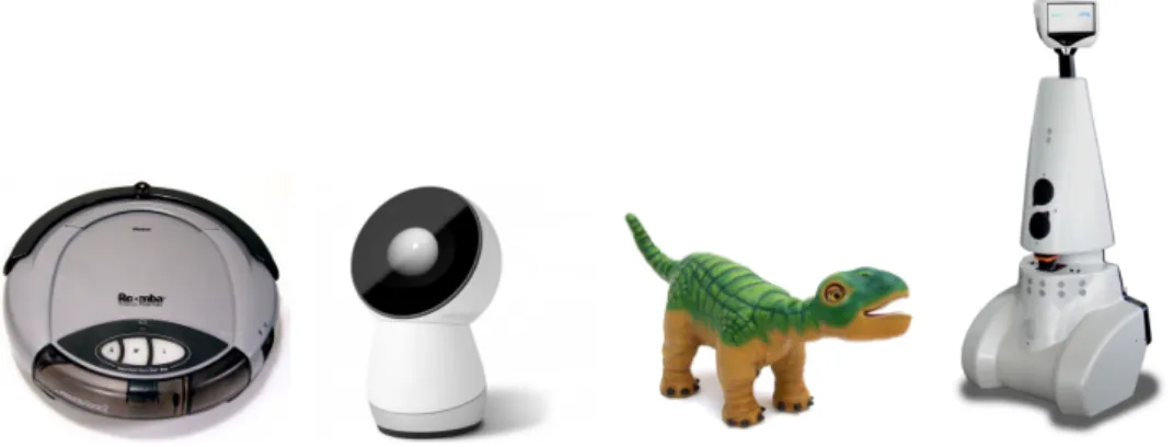
According to the International Federation of Robotics, “in 2013, about 4 million service robots for personal and domestic use were sold, 28% more than in 2012. The value of sales increased to US$1.7 billion”1. So far the available personal robots are mostly floor cleaners, toys, social robots, surveillance or telepresence robots (fig.1.2). It is a really good start, but they are still fairly
1
CHAPTER 1. INTRODUCTION
Figure 1.2: From left to right, Roomba a vacuum cleaner, Jibo a social robot, Pleo a toy robot and Jazz a telepresence robot.
limited and we are still far away from a robot butler.
Nevertheless, due to the progress made in this area and robotics in general, it has become more and more the concern of the scientific community, governments and industries. Each year, an increasing number of investments and fundings are made to support the development of service robots and growth of the industry. The main reason is that they could be a potential solution to many problems facing the modern society. For example, we imagine that a service robot could provide assistance and care for the elderly.
Such a service robot requires many capabilities and functionalities. Many of them have been addressed and solved with notable success since the beginning of robotics. From the navigation perspective, the robot capabilities include to be able to localize itself in the environment, to move smoothly while avoiding obstacles and to recognize objects and places. Those issues have resulted in many sub-domains addressing them such as SLAM, path planning, object recognition and machine learning. In numerous scenarios and applications, the techniques that have been developed in those domains have proven to be efficient. However, as new techniques are developed, new challenges appear. In general, we can say that the fundamental problem is to improve the robots’ understanding of the environment. The more unconstrained and dynamic the environment is, the more difficult the task is. In order to progress in this direction, we will need richer and more abstract representation of the world, as well as more efficient solutions to process those representations.
A household is a very difficult environment to represent in details. It is challenging to have a robot capable of navigating safely and efficiently in such environment, or capable of performing orders like ”go fetch my keys” or ”clean the kitchen”. It requires that the robot can navigate while knowing much about the different objects and places, and be able to reason about them. The robot needs to know what a particular object looks like, where it 2
1.2
is able to find it and so on.
Constructing a representation of the environment which holds the nature of objects and places as well as their positions is the purpose of semantic map-ping. On the other hand, using such a representation to perform meaningful navigation tasks is the concern of semantic navigation. In many senses they are at the crossroad of classical navigation, object recognition and machine learning.
1.2
Target application
The question we asked ourselves at the beginning of this thesis was the following: what if I just bought a robot to help me in my house? What should I expect? Here is the scenario and the considerations we came up with.
Firstly, the robot has just been bought so it doesn’t know anything about the owner or his house. What is the layout? What kind of objects and furnitures does he have? What are his habits? The robot needs to learn all of that. However the end user is not an expert, so training it should be as easy as possible. Also the robot cannot possibly know all of that from a previous training or learning because we don’t all have the same objects or furnitures, and new ones are invented everyday. Finally, we could sometimes move furniture or even change the layout of the house and the robot would need to adapt smoothly without requiring to be extensively trained again. In other words, the robot needs advanced adaptation or learning capabilities. Those skills require to be unsupervised, incremental and real-time.
In this scenario, we can imagine that the robot would start by exploring its surroundings and immediately start building a rich model of the environment. It would then have to update and maintain this representation over time. Then the robot could ask the owner the name of the different places or objects it has identified, thus simplifying the teaching process. We could also imagine the robot fetching information from the Internet. The things that would typically be necessary to name are the places, like the kitchen or the bathroom, and the objects present in the house.
When a new object, a new information or a new situation is perceived by the robot while it is working, it should be able to gather that knowledge and incorporate it, and take a decision right away without having to stop its work. It would be better if the robot could adapt on the fly but it is possible to imagine that later on, when it is in standby, it would go over the newly acquired data and process it. Nevertheless, the user shouldn’t have to train the robot for every new situation it encounters, and it shouldn’t block the robot from doing its job.
Considering this, some of those problems already have efficient solu-tions, and some others have partial solutions. For instance, simultaneous
CHAPTER 1. INTRODUCTION
Figure 1.3: Different semantic map representations. From left to right, an occupancy grid where the room have been extracted and some object are localized, a colored 3D map where the positions of the robot have been annotated with the type of room it recognized, a 3D map where horizontal surface have been segmented, a topological map where the type of room and the positions of the doors have identified along the robot’s trajectory.
localization and mapping (SLAM) works very well in a fairly static environ-ment. Given an efficient SLAM, many techniques exists for safely navigating. However, the problem is that those techniques are based on representations containing little information. Most of the time, the only represented charac-teristic of a location is to be occupied or not. Thus one of the challenge is to have richer environment representation.
In conclusion, our research goal is to obtain such rich representation of the world. We want to be able to build it and maintain it over time, as much as possible without supervision, incrementally and in real-time.
1.3
Related work
Our goal is to build semantic maps automatically and with as less a priori knowledge as possible. We focused on system architecture, object recognition and learning. Here is a brief analysis of related researches in these three areas, aiming at positioning our contributions.
Semantic mapping is a rather new topic of research. A recent survey (Kostavelis and Gasteratos2014) provides a detailed state of the art. The building of semantic maps is based on classical mapping and recognition techniques. So, it is natural that different combinations of popular techniques among those two subtopics were studied. We can therefore divide semantic mapping studies on whether they use metric maps (Iocchi and Pellegrini
2007; Biswas et al. 2002; N¨uchter and Hertzberg 2008; Liu and Wichert
2013), topological ones (Ranganathan and Dellaert2007), or both of them (Kostavelis and Gasteratos2013; Pronobis, Sj¨o¨o, et al. 2010) (see fig.1.3). We can also divide those studies on whether they were focused on place recognition (Kostavelis and Gasteratos 2013), object (Ranganathan and Dellaert2007) recognition or both (Aydemir et al.2011). The main purpose of those studies being the finding of suitable representations to perform semantic navigation.
In the literature, the use of different sensors have been studied. Some 4
1.3
work only uses one modality, the most popular one being RGB-D sensors (Kostavelis and Gasteratos 2013), and other try to benefit from different
modalities (Iocchi and Pellegrini 2007; Pronobis and Jensfelt2011).
To recognize objects or places, popular sensors are the one giving rich information: color and RGB-D cameras, stereo vision, 2D and 3D laser scanner. For navigation purposes on the other hand, more choices are available: sonar range finder, 2D and 3D laser scanner, GPS, IMU, Wifi sensor, different radar technologies and of course cameras. The most popular ones are laser range finders and cameras.
For instance, in (Aydemir et al. 2011) they study the use of semantic maps and cues to perform active visual search. They use a chain-graph for representing object locations and relations. Using decision theory and heuristics on this model they show that they can perform efficient object search. The representation is adapted to reasoning purposes and can be built incrementally without supervision, but the appearances of rooms and objects categories are learned off-line with supervised techniques. In this study two different sensors are used: a 2D laser range finder for navigation purposes and a camera for room and object recognition.
In (Ranganathan and Dellaert 2007), they choose objects as the semantic unit. Visual and geometric features are extracted from a stereo camera, from which objects are recognized. Using those recognized objects, the places are then modeled and recognized. In other words, objects are inferred from visual features, and places are inferred from objects. The object models are learned off-line from a dataset.
The main limitation of those studies is that the robot’s knowledge to rec-ognize places or objects is principally acquired from a dataset in a supervised learning setup (Aydemir et al.2011; Ranganathan and Dellaert2007). It is a limitation because in spite of the powerful representations, the robot can only operate with previously learned objects or places, and the process of learning is rather laborious.
Some works were done on the acquisition of such knowledge with less supervision. For example, in (Mason and Marthi2012) by comparing different runs of the robot and keeping track of the different planes in the environment they segment objects and discover change or novelty. The semantic map is represented as a 2D occupancy grid with 3D geometric models of the objects. So this work provides a way to perform unsupervised object discovery but doesn’t deal with the modeling part. In (Biswas et al.2002) they proposed an occupancy grid mapping algorithm to segment non-stationary objects and represent them as local occupancy grid maps. The work of (Endres et al.2009) uses local shape descriptors with Latent Dirichlet Distribution on 3D range data for object discovery. Their method is unsupervised but not on-line and assumes knowledge of the number of objects in a scene.
However, in most of these works, the unsupervised learning is performed off-line and constrained to certain type of objects, places or scenarios.
Never-CHAPTER 1. INTRODUCTION
theless, incremental and unsupervised learning is the focus of many studies in the computer vision, machine learning and developmental robotics communi-ties. The idea is to build rich knowledge step by step, during operation of the robot and without human intervention. Those studies are usually applied to object recognition with regard to manipulation by humanoid robots (Natalya Lyubova and Filliat2012; Natalia Lyubova, Filliat, and Ivaldi2013; Kemp and Edsinger2006; Montesano et al.2008). Still a lot of those studies could be applied to semantic navigation.
In conclusion, not much work has been done yet to apply incremental and unsupervised learning with multiple modalities to semantic mapping, which is an important practical goal (see section 1.2). We therefore focused our work on these aspects as detailed in the next section.
1.4
Contribution summary
We propose a complete solution to perform incremental and unsupervised semantic mapping working on a real robot. Each aspects of the solution are discussed: the software architecture and all the functionalities needed by the robot. Some already existing techniques have been derived in the effort of integration, others are used as is, but more importantly three different parts of the solution are original contributions:
1. The use of 2D laser range finder to perform object recogni-tion. This type of sensor has some advantages over more popular ones for object recognition such as camera, RGB-D camera and 3D laser range finder. So far numerous semantic mapping solutions are using this sensor for mapping and obstacle avoidance, some work used it to characterize certain aspects of the environment, but we fully leveraged this sensor by developing techniques to use it in the entire process of semantic mapping.
2. Introducing the graph-of-views modeling method. In our effort to extend bag-of-views techniques to perform multi-modal modeling of objects we derived an original formulation which is more elegant and powerful than the former on several aspects.
3. An original incremental and unsupervised learning algorithm. While exploring existing clustering techniques we encountered several limitations. We came up with a new solution to the problem of unsu-pervised learning of object models.
Part of this work was published in three different publications:
• Jean-Christophe Baillie et al. (2011). “Software architecture for an exploration robot based on Urbi”. In: Proceedings of the 6th National Conference on Control Architectures of Robots, pp. 1–12
1.5
• David Filliat et al. (2012). “RGBD object recognition and visual texture classification for indoor semantic mapping”. In: 2012 IEEE Conference on Technologies for Practical Robot Applications, TePRA 2012, pp. 127–132
• Guillaume Duceux and David Filliat (2014). “Unsupervised and online non-stationary obstacle discovery and modeling using a laser range finder”. In: IEEE/RSJ International Conference on Intelligent Robots and Systems (IROS). IEEE, pp. 593–599.
1.5
Outline
This work is structured into seven chapters, including the introduction and is organized as follows.
Chapter2gives a thorough background on all the concepts and techniques needed to fully understand this work. For each item, a state of the art review is provided. The reading of this chapter is necessary for readers with limited knowledge about semantic mapping but can be skipped or be used as reference otherwise.
Chapter 3 will discuss the functional architecture of the robot. The choices made will be explained and discussed. Although it is not a crucial part of this work, it is an important aspect of the solution proposed and necessary to fully understand the other parts of the work. Our studies of the software and functional architecture of a robot for semantic mapping led to two publications: (J.-C. Baillie et al.2011), (Filliat et al.2012).
Chapter4 will present our solution to perform object recognition using 2D laser range finder. Two new descriptors are presented as well as experi-mental results on recognition using them in bag-of-views models. Performing semantic mapping using only a 2D laser range finder have been studied and the work is presented in (Duceux and Filliat2014).
Chapter 5is about our original representation of object. It will discuss the related techniques and show why and how our method is interesting.
Chapter 6will present the incremental and unsupervised learning part. It will explain the limitations we encountered using existing techniques and how our original solution can solve them.
Finally, chapter 7 will summarize our achievements and discuss the limitations and perspectives of this work.
Chapter 2
Background
This chapter gives a short state of the art in all the areas exploited in our work in order to provide context for the understanding of our architecture described in chapter 3. Reading of this chapter is useful for readers with limited knowledge about semantic mapping but can be skipped or be used as reference otherwise. More specific state of the art related to our contributions will be also presented in the following chapters.
2.1
Introduction
Semantic mapping and navigation have mainly one concern: integrating place and object recognition in the navigation process. The central question is how to represent the information so that it can be built, maintained and used efficiently. The navigation tasks that require rich knowledge are for example searching for a particular object, or adapting the behavior of the robot with regard to its context. So a good representation, or semantic map, is one that makes reasoning about places or objects easy. For instance, if the end-user asks the robot to fetch the car keys, the robot needs information such as the appearance of the object, where it has been seen last, where it usually is or what other objects can be found near the keys. Once the robot retrieves those information, it then needs to make an efficient plan to fetch the keys, which involves where to look first and how to get there. Having a smart autonomous robot therefore requires the ability to manipulate rich and heterogeneous information about the environment.
Most of the underlying computation needed to acquire and manipulate specific information about the robot and the environment have been already extensively studied. Perhaps the most important is the localization of the robot and the representation of its environment. This problem is known as simultaneous localization and mapping (SLAM) and will be reviewed briefly in the section2.2. One solution to this problem provides an estimate of the location of the robot and a rudimentary representation of the environment
CHAPTER 2. BACKGROUND
Figure 2.1: Diagram of the SLAM process. The inputs are proprioceptive sensors(such as wheels encoders or a inertial measurement unit) and extero-ceptive sensors (such as a camera or a laser range finder). The outputs are a map of the environment and the location of the robot in the map.
suitable for basic navigation. On top of that, there is the problem of path planning and obstacle avoidance described in the section2.3 which makes it possible to plan and adjust a safe trajectory towards a goal given a localization of the robot, a map of the environment and a target location. If the environment contains dynamic obstacles one might need a tracking module (section2.4) to estimate displacement and position of those obstacles.
Those techniques have been studied for a long time and efficient solutions do exist, but they don’t provide any information about the nature of places or objects. Those are the focus of object and place recognition described in section2.6which often involves the detection and segmentation (section 2.5) of the sensors output.
Semantic mapping aims to incorporate the nature of objects and places in the navigation techniques as discussed in the section1.3. In section 2.7, we will discuss the informations stored in semantic mapping and how it is represented as well as how it is used for robot tasks.
Finally, how to bring all those functionalities together in one robot is difficult. It is the robot architecture problem which will be reviewed in section2.8.
2.2
Environment representation, robot localization
and mapping
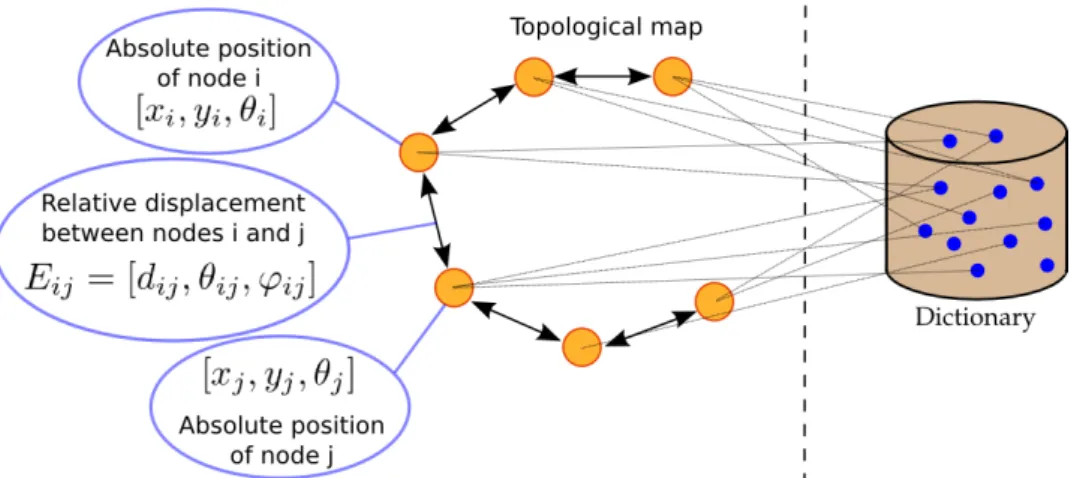
Maybe the most fundamental problem in navigation is to know where the robot is. In order to do that, the robot needs to localize itself with regard to a certain representation of the world. But to build it the robot needs to keep track of its location. This chicken-and-egg problem is famously known has the “simultaneous localization and mapping (SLAM)” problem. It has been studied for a long time and several efficient solutions exist. The essential and classical ones are described with details in (Thrun, Burgard, and Fox2005). The figure2.1illustrates this process. We will not have space for an in-depth review of SLAM, and we will therefore only detail a few approaches related 10
2.2
Figure 2.2: A topological map. Each node represents the position and appearance of a location. Each edge represents the relative displacement between nodes. In this work appearance is coded via bag-of-words method whose dictionary is represented on the right (Angeli et al.2009).
to the map representation to introduce the simple metric representation that has been used in our work.
There are mainly two different paradigms when representing the envi-ronment: topological representations and metric representations. In the first case, the environment is represented by a graph of discrete locations. This can be very compact and distinctive, and it is easily embedded with semantics. However, this kind of representation requires a high level of abstraction of the raw data, and extracting those discrete locations reliably and robustly is difficult. Figure 2.2 shows an illustration of such a map from (Angeli et al.2009). The metric representation on the other hand, represents the environment using raw data (or features with a low level of abstraction) in a metric space, which can result in a very precise representation. However the required volume of data often scales very badly with the size of the environment, and it is harder to embed with semantics. Recent works in this field have produced various hybrid combinations of those two representations (Tomatis, Nourbakhsh, and Siegwart2003).
For this study, we used a metric representation called occupancy grid (Elfes 1989) which is common when using a 2D laser range finder. An occupancy grid (see figure2.3) represents the environment as a grid of evenly spaced cells memorizing the presence or not of an obstacle. Generally a cell holds the probability of being occupied or not. Many SLAM algorithms use this representation. Popular techniques for localization and mapping using this representation are based on a particle filter (Hahnel et al.2003) or expectation maximization as reported in (Burgard et al. 1999). In a recent popular SLAM (Kohlbrecher et al.2011), they use an optimization algorithm based on a fast approximation of map gradients and a multi-resolution grid
CHAPTER 2. BACKGROUND
Figure 2.3: An occupancy grid. White represents free cells, black are occupied cells and gray are unexplored. This map was produced by our perception pipeline using the HectorSlam algorithm (Kohlbrecher et al.2011).
to perform fast localization. Overall, those techniques are efficient, robust and are used in commercial products. They are usually used with laser-based or sonar-based systems.
One limitation of this representation however is that it is based on the assumption that the environment is static. Some studies provide solutions to remove this limitation (Meyer-Delius, Beinhofer, and Burgard2012; Mitsou and Tzafestas2007; Arbuckle, Howard, and Mataric 2002). In the first one, their method represents both the occupancy grid and its changes in the corresponding area. The dynamics are characterized by the state transition probabilities of a Hidden Markov Process. Furthermore, they propose an on-line learning technique to estimate the model parameters from data. They have shown that their representation is more accurate and can be used to improve SLAM and path-planning. In the second one (Mitsou and Tzafestas2007), for each cell of the occupancy grid, instead of only storing a probability, they store a time index which holds efficiently a history of the cells. They have shown that because they store all the information, it is possible to use this representation to retrieve the static and dynamic areas of the environment, as well as footprint of non-stationary objects. Finally in the last one (Arbuckle, Howard, and Mataric2002) they consider occupancy over different time scales and show that it can be used as a tool for classifying motion in an area.
2.3
Figure 2.4: A possible diagram path planning and obstacles avoidance processes. Given a representation of the environment and a destination, the path planning process will compute a path that the robot will follow to reach its target (similarly to a Global Positioning System). However, usually this path doesn’t account for dynamic obstacles. Thus another module called obstacle avoidance is used to follow the path while avoiding obstacles.
2.3
Obstacle avoidance and path planning
Path planning is the study of how to generate a series of actions so that a robot can go from a given configuration to a target one. Obstacle avoidance is concerned with how to ensure that a robot won’t collide with an unforeseen obstacle. Those fields are closely related. The different techniques from these studies strongly depend on the representation of the environment and the available sensors. Figure2.4 illustrates a commonly used diagram of such processes.
The navigation architecture is often divided into two layers (L. C. Wang, Yong, and Ang Jr 2002). The first one is a deliberative layer which compute a global plan to perform a certain task. This layer needs a complete and accurate knowledge of the world, and the computation involved might be time consuming. Because it is not possible to have a complete knowledge in advance, a reactive layer is there to prevent collisions in case of unforeseen obstacles. The reactive layer would control the robot until the deliberative layer takes into account the new information. Solutions from the obstacle avoidance field are used in the reactive layer, whereas path planning ones usually fall into the deliberative layer.
Reactive behaviors for robots have been studied early. There are two ideas behind the different techniques developed (Zohaib et al. 2013). The first one is to turn around the obstacle when encountered, until some criteria are met. This idea is the basis for the Bug algorithms family (Ng and Br¨aunl 2007). They tend to be time consuming and have different practical limitations. The second one is the potential field idea (Khatib1986). The goal is modeled as generating an attractive force and the obstacles are generating repulsive ones. Applying the generated field to the robot makes it move toward the goal while avoiding obstacles. Those methods are less time consuming than the bug one but they get stuck in local minima. For instance U-shaped obstacles are often a problem for potential field based solutions.
CHAPTER 2. BACKGROUND
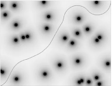
Figure 2.5: Field D* planning through a potential field of obstacles (Ferguson and Stentz2007). Obstacles are represented in black. The curve line in the middle is the path produced by the algorithm.
Those have a short-term memory world model to plan better and avoid the shortcomings of reactive behaviors methods while being fast enough.
In the method called Vector Field Histogram (VFH) (Borenstein and Koren1991), a histogram grid of fixed size centered around the robot position is maintained and updated with sensory information. This histogram grid which represents a short-term memory world model is processed in two steps to produce a velocity vector to command the robot. The first step consists in transforming the histogram grid into a polar histogram around the robot’s momentary location. Each sector of this representation describe the density of obstacles in a certain direction. The second step compute a steering direction and a velocity taking into account the previously computed obstacle density the direction of the target.
Other popular approaches are derivatives of the Dynamic Window (Fox, Burgard, and Thrun1997). In those, the kinematic constraints of the robot are taken into account by searching a solution into the velocity space of the robot. The dynamic window contains the admissible velocities achievable by the robot given the current acceleration and velocity. The admissible velocities are the one that allow the robot to come to a stop before collision with an obstacle. The command for the robot is selected by choosing the one that maximizes an objective function which takes into account the goal position and distances to obstacles. This method is improved in (Brock and Khatib1999), where a small occupancy grid is maintained centered around the robot as in the VFH approach. This grid is used to compute a variant of Dijkstra’s algorithm (Dijkstra1959) which allows to favor direction towards
2.4
Figure 2.6: Diagram of the Detection And Tracking of Moving Objects (DATMO) process. Given an exteroceptive sensor, the DATMO system
detects objects of interest and estimates their displacements.
the goal free of local-minimum.
Those solutions are not adapted to control the robot toward a far away goal, but they are efficient to avoid unforeseen obstacles while following a path. This path is given by a path planning solution.
For mobile robots in indoor environment, given a representation of the world, most of the time provided by a SLAM module, graph-based methods are popular to find a path from the robot to a destination. The study of those methods started with Dijkstra’s algorithm (Dijkstra 1959) up to the current D*lite (Koenig and Likhachev 2002) and Field D* (Ferguson and Stentz2007) through successive improvement. The figure2.5 illustrates a path obtained from this method.
Dijkstra’s algorithm is the simplest algorithm to compute the shortest path in a graph. It is usually sufficient when the search space is small, but is limited when the environment grows. The first improvement over Dijkstra’s algorithm was to use a distance heuristic to improve the search. This is the A* algorithm (Hart, Nilsson, and Raphael 1968). The idea is that by searching the nodes closer to the goal first based on the heuristic used, the solution is found faster. Another improvement is to compute the graph from the destination to the robot position. This way it is faster to compute a new path when the robot moves or when newly perceived obstacles are added to the representation, because the path only needs to be updated locally. Finally, in the Field D* algorithm, interpolation is used to compute the traversal cost of cells so that the overall path is computed in the continuous space instead of the discretized one. This makes the resulting path smoother and more realistic for the robot to follow.
2.4
Moving object tracking
Dealing with dynamic objects is essential for mobile robots in almost every scenario. This problem is often referred to as Detection And Tracking of Moving Objects (DATMO) (Pancham, Tlale, and Bright2011). In short, it
CHAPTER 2. BACKGROUND
consists in estimating the position and the trajectory of detected dynamic objects from the perception stream. Figure 2.6 illustrates this process. This has been the major focus for video surveillance and automated car applications. Recent works (C.-C. Wang et al. 2007) are integrating this with SLAM (which is called SLAMMOT: Simultaneous Localisation And Mapping with Multiple Object Tracking) to improve overall performance. Here we will only discuss the tracking aspect since detection will be discussed later in section2.5.
There are two problems in the tracking process. The first one is the data association problem: how to correctly associate the currently tracked object states with the incoming perception of multiple detections. The association has to account for newly perceived objects, those that are not visible anymore, those coming close together and those splitting apart. In the review (Pancham, Tlale, and Bright2011) the popular data associations techniques reported for SLAMMOT application are the Global Nearest Neighborhood (GNN) (Blackman and Popoli1999), the Joint Probabilistic Data Association Filter (JPDAF) (Fortmann, Bar-Shalom, and Scheffe1983) and the Multiple Hypothesis Tracking (MHT) (Reid 1979). For a given number of tracks and current measurements, a set of possible associations is calculated for each track. This is referred to as gating. The GNN approach keeps only the best possible association, whereas the JPDAF combines all of the potential candidates for association to a track in a single statistically most probable one. Those methods only keep a single hypothesis about measurements received in the past. The MHT on the other hand consider multiple associations hypotheses over time.
The second problem is filtering to correctly estimate the trajectory and state of the objects. Popular techniques include Kalman Filters (KF) (Kalman
1960), Particle Filters (PF) (Gordon, Salmond, and Smith 1993) and Inter-acting Multiple Models (IMM) (Blom and Bar-Shalom1988). The KF is a recursive method which keeps track of the estimated state of the system and its uncertainties through a Gaussian model. Those are updated using a state transition model and a new measurement. Particle filters use a sampling approach to estimate the posterior density of the system state by applying the Bayesian recursion equations. In their basic form they are susceptible to a mismatch between the state transition model and the real motion of the targets. A popular solution is the IMM which is an estimator using multiple filters with different transition models.
2.5
Object detection, segmentation and discovery
Detection of unknown objects in robotics context can be made using differ-ences between maps or world models constructed at different times, assuming that the objects of interest will eventually move. The work in (Herbst et al. 16
2.5
2011) is based on 3D maps represented as point clouds. They compare two maps of the same environment by registering the 3D scenes together and use the map differences as possible objects. A similar approach is used by (Biswas et al. 2002) using 2D occupancy grid maps. They detect changes by a straightforward comparison of occupancy grids. Connected components of occupied cells in that difference are considered to be objects. Using the expectation maximization algorithm, they reconstruct the models of the different objects.
Others work directly with sensor data. For example, (Mason and Marthi
2012), (Filliat et al.2012) and (Aydemir et al.2011) use plane segmentation based detection on depth images to discover or search for objects. The objects are therefore supposed to stand out of flat surfaces such as the floor or a table.
Another approach is to compare the current observation to a world model. For instance, (Modayil and Kuipers 2004) uses a filtering method on range data localized by a SLAM technique to discover novelty. Once the laser reading has been registered, each endpoint either confirms or contradicts the occupancy grid. If a group of endpoints conflict with the occupancy grid, it is most likely caused by a non-stationary object.
Using those detections and segmentations, it is possible to perform object discovery which is reconstructing models of unknown objects from partial observations. In (Collet, Xiong, et al. 2013), the authors use a constraint similarity graph. The graph’s nodes contain segmentations that represent candidate objects. To generate a candidate, the approach described in (Collet, Srinivasa, and Hebert 2011) is used. This method employs different cues from color and range information to form a well structured region based on a metric they developed. For each candidate they store color and geometric information as well as meta-data (position, time, is it planar or not, seen on a table or not, etc...). The edges of the graph are the similarities between nodes computed from these various data. By clustering nodes in the graph they can reconstruct the object models.
In computer vision, as the task of discovering objects without prior knowledge is difficult, statistical methods are often used over large datasets to find reoccurring patterns. A metric was proposed in (Tuytelaars et al.
2010), to compare different techniques. It was then used with popular methods applied to two different public datasets. The datasets are composed of images of objects from different categories. The images from the first dataset contain only one object, while there can be multiple objects per image in the second set. The images are represented as bag-of-words (Csurka et al.2004; Y. Zhang, Jin, and Zhou 2010). Two categories of methods were tested: latent variable models and spectral clustering, showing that spectral clustering performs better when a single object exist in each image, but that latent variable models are better suited when objects appear in multiple instances. In (Russell et al.2006), they use a technique to obtain multiple
CHAPTER 2. BACKGROUND
segmentations from each image. Those segments are modeled as bag-of-words and categories are discovered using Probabilistic Latent Semantic Analysis and Latent Dirichlet Allocation following methods from the text analysis community. Once the categories are discovered the segments are filtered to extract the good ones. Thus they can jointly discover object categories and segment them in the corpus. Spectral clustering is also used in (Fu et al.
2008). In this work they represent an image as a set of unordered features. They produce a graph where each image is a node and where edges represent the partial matching between images. Using different refining methods on the graph they can extract meaningful set of features representing objects across images.
2.6
Object modeling and recognition
There are mainly three ways to model and recognize objects using range data, as will be done in our thesis.
The first way is to use registration or scan matching to generate and recognize geometrical models. In (Herbst et al. 2011) and (Modayil and Kuipers 2004), they align surfaces belonging to an object in 3D and 2D range data respectively. By aligning those surfaces, they obtain a model of the object consisting of a point cloud as it would be seen by the sensor if it could see the entire object. Those approaches are very susceptible to noise in sensor data, and are not well suited for modeling objects with changing shapes like people.
The second approach is to extract invariant local features from observa-tions and to differentiate objects based on the set of features they possess. The work of (Endres et al.2009) uses local shape descriptors with Latent Dirichlet Distribution on 3D range data. Their method is unsupervised but not on-line and assumes knowledge of the number of objects in a scene. An object is represented in this case as a distribution of local surface shapes. This kind of object model is more robust to noise in sensor data and change in object appearance. They are usually faster and more efficient than geo-metrical models to learn and to recognize. The use of local features has also been widely studied by the computer vision community as will be reviewed at the end of this section.
The third way is to create multi-view object models by regrouping the views of an object from different viewpoints or different times. This approach is used in (Natalya Lyubova and Filliat2012), based on vision and takes advantage of object manipulation by a robot to gather different views of the objects. Using tracking techniques to put together different views have also been used in (Modayil and Kuipers2004) using laser scans. Views are usually encoded using a descriptor or signature. Many of these exist in vision or 3D, but far fewer for 2D range data. Nevertheless, (Tipaldi and Arras 2010)
2.7
shows that it is possible to use descriptors with laser range finder, applied to place recognition in their case.
Among the numerous approaches existing in computer vision that we will not be able to review here, extracting local features from images as a first step to object recognition is very popular (Campbell and Flynn
2001). Most of the time, it requires the encoding of certain properties of the appearance into descriptors, and the clustering of those properties. SIFT (Lowe2004) and SURF (Bay, Tuytelaars, and Van Gool 2006) are frequently used to describe points of interest. Using local features, a popular way to represent objects is as a set of local features. In particular the Bag-of-Word representation (Csurka et al. 2004), which as been developed originally in the text analysis community (Joachims1998), is frequently used or derived. Recently, due to the apparition of cheap RGB-D sensors, this approach has gained in popularity and different descriptors and keypoint detectors have been developed to work on this kind of data (Filipe and Alexandre 2014; Rachmawati, Suwardi, and Khodra2014).
2.7
Semantic mapping
Semantic Mapping studies are concerned with producing a world model not only representing the appearance and spatial layout of the environment, but also with places and objects identified, categorized and localized. The aim is to add semantic knowledge to the classical navigation techniques in order to overcome their shortcomings. Semantic mapping offers several advantages such as simplifying information sharing about the environment with a human operator. It also helps modeling possible interaction with objects and their dynamics which is interesting because most computation involved in navigation could be improved with such knowledge. For instance, knowing about the floor properties can help having better estimate of the robot displacement, or knowing about the location of different visible objects can help with the localization. Semantic mapping is a promising direction towards improving environment representations and robots autonomy.
Most of the proposed semantic map models in the literature are layered representations containing metric, topological and conceptual information (Pronobis and Jensfelt 2012; Galindo, Saffiotti, et al. 2005; Ranganathan and Dellaert2007; Vasudevan and Siegwart2008). One of the first model proposed by (Galindo, Saffiotti, et al. 2005) is a double parallel hierarchical structure. The first structure is a spatial representation where the lower level represents sensory readings, the second level contains a topological map of the environment and the third level is a single node representing the whole environment. The second structure represents the different concepts of place and object and their relationship. The two structures are linked by anchoring of concepts to spatial locations. One of the most complete
CHAPTER 2. BACKGROUND
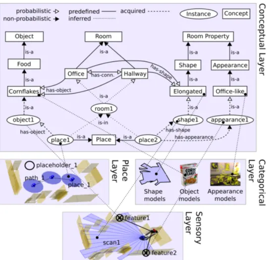
Figure 2.7: The layered structure of the semantic map representation pro-posed in (Pronobis and Jensfelt 2012). The conceptual layer comprises knowledge about concepts (rectangles), relations between those concepts and instances of spatial entities (ellipses). The categorical layer contains every information necessary to recognize the different places and objects present in the environment. The sensory layer contains an occupancy grid of the environment. Finally, the place layer contains a topological map which links the concepts to the different geometric locations.
2.7
model for indoor environments is presented in (Pronobis and Jensfelt 2012). It is a spatial representation with four layers (see figure2.7). The first one called sensory layer contains a metric map of the environment and represents the lowest level of abstraction. Above, the place layer is a topological map containing locations, paths and placeholders. The categorical layer is the learned knowledge of the robot. It contains objects and places appearances as well as models for recognition purposes. Finally the conceptual layer represents the relationship between objects, places and their properties.
Another approach is to annotate metric maps with semantic information. In (N¨uchter and Hertzberg 2008) they proposed to annotate point clouds produced with a 3D laser scanner. The solution contains three steps: 6D SLAM, scene interpretation which extracts the ground, ceiling, walls and doors from the point cloud and finally an object classifier to label the remaining parts of the point cloud. The classifier is previously trained and uses the ICP technique against a known 3D geometrical model to recognize the objects. The information about walls and the ground are used to improve the quality of the model by enforcing their perpendicularity.
Both approaches are used in the semantic map structure proposed in (Drouilly, Rives, and Morisset 2014). Their map called
Metric-Topological-Semantic map (MTS-map) consists of 3-layered local sub-maps globally connected to each other into different graph structure. The bottom layer of the local sub-maps is an RGBD spherical view of the environment acquired with a multi-cameras system. This layer represents the sensor view and provides both metric and color information. The second layer is extracted from the spherical views by labeling it pixel wise using a supervised classification method. The top layer is a semantic-graph in which nodes are the different consistent regions in the labeled image and edges represent the connection between these regions. Those semantic sub-maps are used in three different structure. Firstly, they are connected into a graph structure with edges representing relative pose estimation between the sub-maps which forms an hybrid metric-topological map of the environment. Secondly, they are clustered according to their content similarity into a tree structure. With this structure they can perform efficient relocation using semantic information at a coarse level and sensor measurements at a fine level. Finally, they use a conceptual graph to characterize non-spatial relations between categories.
One of the concern about semantic representation is how it can be used to perform abstract tasks such as searching for objects. A popular approach is to plan tasks using logical reasoning about objects, places and their spatial relationship (Kunze et al.2012; Galindo, Fernandez-Madrigal, et al. 2008; Aydemir et al.2011). In (Kunze et al.2012) they propose a decision-theoretic approach for fetch-and-delivery tasks. To do so, they extend the semantic representation of (Tenorth et al. 2010) to handle large-scale environment and multi-level building. The basic idea is to select the search location that maximizes an expected utility function which is determined by the probability
CHAPTER 2. BACKGROUND
of success, travel costs and task context. The possible search location are obtained through logic calculus on the conceptual layer of their world model. They demonstrate their method with a robot system that successfully fetch a sandwich within a multi-level building.
Another concern is to use semantic information to outperform existing techniques solely based on metric information. Traditional path planning optimize the path length and obstacle clearance. In (Drouilly, Rives, and Morisset 2015), they use the MTS-map to perform path planning using higher-level constraints. For instance, by taking into account the visibility of the landmarks along the computed routes, they can compute a path which is short in length, while ensuring that the robot will not get lost. Furthermore, they propose a way to extract a high-level description of a computed route by using semantic information. Finally, in (Drouilly, Papadakis, et al.2014), they propose to improve the mapping process by extrapolating the environment based on extracted semantic information.
2.8
Robot architecture
Building a robot and programming it to perform tasks as complex as se-mantic mapping and navigation is not an easy problem. There are many considerations to take into account. At the very beginning, there is the robot’s purpose: what do we want to accomplish with the robot. Then comes the hardware: what kind of sensors or actuators can we use to accomplish such goals, what processing power do we require. Once a purpose for the robot is set, and the hardware has been decided, the robot needs to be programmed. There are two sides of the robot software. Firstly, there is the programming of the different functionalities and computations required by the system, which are referred as the software components. Secondly, there is the software architecture which is how the components are arranged and how they interact together. All of this forms the robot architecture.
In the last decades, a lot of work was dedicated to the design of robot architectures. There are mainly three paradigms for these architectures (Nakhaeinia et al.2011): deliberative, reactive and hybrid. In the deliberative one, also called hierarchical, the robot gathers the data from its sensors into a global world model and plans at each step the next action. The advantage of this type of system is that it is possible to plan complicated tasks in a top-down and long term fashion. The main disadvantages are that it’s usually heavy on computation and obtaining an accurate model of the world is difficult. In the reactive paradigm, the robot has multiple couples of sense-action called behaviors which are independent of each other. Given a certain situation, the robot will do a combination of behaviors following a set of rules. For example, in the subsumption architecture (Brooks et al.1986) the behaviors are organized in layers with priorities depending on the situation. 22
2.8
The main advantage is that it’s easier to obtain a fast reaction from the robot because there is no need to process the newly sensed information into a world model. Instead each component gets a small piece of more grounded information and sends an action to the robot. The disadvantage is that sometimes complex planning is required and designing a robot with this type of architecture is then very difficult. Naturally, most of the architectures fall into the third category, the hybrid paradigm, which is a combination of the two first and exists in many variants.
For instance, the work of (Rosenblatt1997) presents an architecture where behaviors of the robot are distributed and all output votes for the possible commands. One of them is selected through an arbiter. The behaviors can be either of deliberative or reactive nature. This has the advantage of limiting the need for sensor fusion or a monolithic world model. By distributing behaviors and only coupling them in the command space, the architecture can be easily updated and maintained. By distributing behaviors through computers or independent processes, the whole system is more efficient and reactive. However, in their solution, commands issued to the arbiter have no semantic value which is limiting. Recent work on architecture tend to perform command or action selection using a task planning functionality (Scheutz et al. 2007; Hawes, Wyatt, and Sloman 2009). Another popular approach to hybrid architecture is using a hierarchy of sub-architectures. In (Connell1992), they propose an architecture with three different layers called servo, subsumption and symbolic. The first layer servo is performing the initial sensor processing and the actuators control. The second layer is a subsumption architecture receiving detected situations form the servo layer and issuing commands to it. They are both reactive sub-architectures. The subsumption layer communicates failures and achievements to the symbolic layer through events which change the parametrization of the second layer to adapt the behavior of the robot. This symbolic layer is a deliberative one. The advantage of this solution is that it preserves the reactivity of the system with low level reactive sub-systems and allows longterm and complex reasoning with a deliberative layer. However, in this form the overall architecture is very constrained.
Nowadays, as robots become more complex and computers more powerful, the robot software architectures are often data-flows of concurrent and distributed modules, with less considerations for which paradigm they fall in.
In (Scheutz et al. 2007) a generic architecture called DIARC is presented and implemented on a real system. The system contains concurrent software components divided in three layers: perceptual, central and action processing. The perceptual layer is able to call for immediate action through high priority actions ensuring the reactivity of the system when facing danger. Those layers are further divided in 6 different modules running across three computers. In their work, the action selection is done using priorities based on a cost-benefit analysis and influenced by the perception of the environment. They stress the
CHAPTER 2. BACKGROUND
need to have mechanisms to recover from failure in such a complex system, which is done in their work by monitoring the progress of on-going tasks and modulating the priorities of the different tasks.
To facilitate the implementation of such architecture, the robotic commu-nity has seen the emergence of efficient robot middleware. They simplify the integration and maintenance of the robot by taking care of inter-components communication and by providing tools to develop, debug, visualize and other helpful utilities. For instance in this work both the Urbi (J.-c. Baillie et al.
2008) and ROS (Quigley et al. 2009) framework were used. Nevertheless, theoretical and practical tools to efficiently engineer and design robots (Ra-maswamy, Monsuez, and Tapus 2014) are still needed. Research on the matter is recently gaining in importance.
The next chapter will present the hybrid architecture developed during our work.
2.9
Conclusion
Performing semantic mapping is a complex task which involves computing different types of representations in order to capture a rich knowledge of the environment. In this chapter we have seen the different techniques and representations commonly found in a semantic mapping solution, and we briefly discussed the issue of integrating such techniques in a robot architecture. After a thorough study of semantic mapping’s state of the art, we found mainly three aspects of existing techniques which could be improved. The solutions we came up with are tightly interconnected to solving the three issues we identified.
Firstly, most of the studies use a camera to recognize the nature of objects and places in the environment (Kostavelis and Gasteratos 2014). Recognizing objects with a camera has been studied to a large extent by the computer vision community and state of the art techniques can achieve high performances. However, in a domestic robot setup, several limitations remain. Cameras often have a limited field of view which can actually be used to recognize objects. Moreover, the information they provide is very rich and therefore hard to process in a timely manner, leading to processing images that are taken from far away position when moving the robot. As a result, a robot mostly takes arbitrary images of the environment to perceive it, and in the majority of those images, objects are ill positioned in the camera field of view which results in poor recognition results. To cope with that, a solution is to ensure that the robot takes good pictures by moving it in front of interesting objects. Popular solutions to that problem are visual saliency techniques (Harel, Koch, and Perona2006). However, since many studies - including us initially - use a 2D horizontal laser range finder to perform navigation and geometric mapping of the environment, we decided 24
2.9
to solve this problem by using a laser range finder in order to enhance the robot’s perception of objects. We were inspired by studies which show that 2D shape of objects are recognizable and that classical techniques can be applied to a laser range finder (Modayil and Kuipers2004; Tipaldi and Arras
2010). In chapter3, we will present how our laser range finder is used to detect objects and how it is integrated in our semantic mapping solution. In the chapter4, we study how we achieved object recognition using this sensor.
Secondly, many studies use only one property or modality to recognize objects. However, an object can be described in terms of many properties such as its shape, color, texture, functionality and so on. A solution to recognize objects which would use different properties should achieve higher performance and robustness. Furthermore, we have discussed how a laser range finder could be used to improve a camera based object recognition system. We therefore need a solution that can use both sensors information to represent an object. Last but not least, as we will discuss in the next paragraph, we want to incrementally learn models of objects. To solve those three issues, we developed an original object representation which is detailed in the chapter 5. This work was inspired by (Mei, Sibley, and Newman
2010) which extends the bag-of-words technique in a meaningful way. The representation we came up is similar in nature but used in a very different way. We will show how we can use our representation to represent and recognize objects based on various sensors and modalities, and how it can be used to incrementally learn objects’ models.
Finally, most of existing semantic mapping solutions use supervised machine learning techniques to learn and recognize objects. We believe for several reasons that it is not a pragmatic solution for domestic robots. Households have a limited number of objects but they come in many flavors. It is therefore impossible to store a dataset of objects’ models on a robot which would cover every possible object it could encounter. Besides, if a robot is to stay in a particular environment, the most obvious and efficient solution is for the robot to store only representations of objects present in this particular environment. We can imagine the robot downloading from a cloud dataset the models it needs (Waibel et al.2011). This is probably a good solution since most robot use cameras to recognize objects. However, sensors and households come in many different flavors and evolve over time. Maintaining such a database would be a great undertaking. On the other hand, adapting to an environment might be achieved through unsupervised learning techniques. If such learning were to be successful, robots would acquire models with their own sensors and only useful knowledge. This could lead to more reliability and efficiency in the robot’s perception of its environment. We believe both solutions are complementary. However, little study have been made yet on using unsupervised techniques in a semantic mapping context. We pursued this idea and developed an original unsupervised learning technique which is detailed in the chapter6.
Chapter 3
Robot architecture for
semantic navigation
In this chapter, we will describe the two robot architectures that we developed during our work. While we do not propose theoretical contributions in the development of these architectures, we want to emphasize the importance of these architectures and the large amount of work represented by their development. We also think that some of the design choice made could be of interest for future developments.
3.1
Introduction
As mentioned in the introduction, we aim at making a robot able to fulfill the scenario presented in section 1.2. In order to do so, the robot must possess many capabilities, some of which have already been the focus of numerous studies with notable success. From the navigation perspective those capabilities are dealing with moving objects, appearance variations and other dynamic changes of the environment. Some of those needs to be solved using machine learning, which might add the difficulty of having to learn with minimum supervision from a non-expert human. Putting the different solutions together means integrating them in a coherent architecture. We should also consider that in practice we would need solutions that can be easily maintained and updated.
During our thesis, we elaborated two robot architectures for the integra-tion of these funcintegra-tionalities. The first architecture was developed in order to participate to the D´efi CAROTTE (J.-C. Baillie et al. 2011; Filliat et al.
2012). The goal of this challenge was to have a robot autonomously explore an unknown environment and produce a semantic map containing rich infor-mation usable by a human. The second architecture is an adaptation of it to support the contributions this work, in particular the capability to discover and model dynamic objects autonomously as described in the next chapters.
CHAPTER 3. ROBOT ARCHITECTURE
Figure 3.1: A photo of the robot used during D´efi CAROTTE.
In this chapter, these two architectures will be presented and all the functionalities will be introduced at least briefly, while some of them which were the subject of our main contributions will be detailed in the following chapters.
3.2
Hardware
We participated to a challenge called ”D´efi CAROTTE” which stand for ”Cartographie par Robot d’un Territoire” organized by the French Defense Procurement Agency (DGA) and financed by the french National Research Agency (ANR). The goal of the challenge was to explore an unknown en-vironment and produce a semantic map of it. The map had to contain information about the different rooms, floors, walls and objects present in it. The environment included difficult obstacles like mirrors, windows and gravels.
The robot used during this work was a Pioneer 3 dx mounted with a camera looking down used for the floor classification, a RGB-D camera (Kinect) for object recognition, walls classification and obstacle avoidance, a sonar belt for obstacle avoidance (especially windows and mirrors) and a 2D laser scanner for the SLAM (see fig. 3.1). The laser scanner used is an hokuyo utm-30lx. It has a precision of 0.03m from 0.1m to 10m, an angular resolution of 0.25 degrees and an angle of view of 270 degrees. The kinect 28