HAL Id: hal-01001300
https://hal.archives-ouvertes.fr/hal-01001300
Submitted on 3 Jun 2020
HAL is a multi-disciplinary open access
archive for the deposit and dissemination of
sci-entific research documents, whether they are
pub-lished or not. The documents may come from
teaching and research institutions in France or
abroad, or from public or private research centers.
L’archive ouverte pluridisciplinaire HAL, est
destinée au dépôt et à la diffusion de documents
scientifiques de niveau recherche, publiés ou non,
émanant des établissements d’enseignement et de
recherche français ou étrangers, des laboratoires
publics ou privés.
How can landscape management be enhanced by
farming systems ? A landscape agronomy perspective
Davide Rizzo, Sylvie Lardon, Hélène Rapey, Marta Debolini, Claudine
Thenail, Marc Benoit
To cite this version:
Davide Rizzo, Sylvie Lardon, Hélène Rapey, Marta Debolini, Claudine Thenail, et al.. How can
landscape management be enhanced by farming systems ? A landscape agronomy perspective. 10.
European IFSA Symposium, International Farming Systems Association (IFSA). AUT., Jul 2012,
Aarhus, Denmark. 9 p. �hal-01001300�
How can landscape management be enhanced by farming systems? A
landscape agronomy perspective
Rizzo D.1, Marraccini E.2, Lardon S.2, Rapey H.3, Debolini M.4, Thenail C.5, Benoît M.1 1 INRA, UR 055 SAD ASTER, 88500 Mirecourt, France.
2 INRA and AgroParisTech, UMR 1273 Métafort, 63172 Aubière, France 3 IRSTEA, UMR1273 Métafort, 63172 Aubière, France
4Institute for Life Sciences, Scuola Superiore Sant' Anna, 56127 Pisa, Italy 5 INRA, SAD-Paysage, F-35042 Rennes, France.
Keywords: European Landscape Convention, farming practices, land management units,
agricultural landscape features.
ABSTRACT:
Agronomists are faced to the multiple stakeholders’ landscape design as a rising issue in the management of farming systems. Furthermore, the European Landscape Convention (ELC) has formally acknowledged the expectations of local stakeholders and decision-makers for a greater support to protect, manage and plan the landscapes. A renewed perspective of agronomy on landscape research has recently tried to tackle this challenge. This perspective, called “landscape agronomy” (LA), strives to widen again the agronomic spatial focus beyond the field or the farm to the landscape. For that, LA has proposed a conceptual model of agricultural landscapes to relate farming practices and natural resources with the continuous reshaping of land use patterns operated by farmers. Interpreting the ELC landscape definition accordingly, we consider that the character of agricultural landscapes results uppermost from farming practices. On this
underpinning assumption we have further developed the LA conceptual model to characterize some land management units of rural spaces. Our aim is to articulate landscape management with farming systems. In this paper, after a short presentation of the LA conceptual model, we analyze the agricultural landscape features as example of elementary management unit. Finally, we discuss how the landscape management by farming systems can help to structure the interaction of agronomy with other disciplines, such as geography and landscape ecology.
1. An agronomic perspective on landscape issues
The increasing social demand for preservation of landscapes and environment has been placed at the heart of the integrative territorial planning by the Council of Europe with the treaty n. 176, also known as “European Landscape Convention” (hereafter ELC). With this treaty, the Council of Europe has provided one of the most advanced legislation on landscape issues (Jones et al., 2007). Indeed, it is the last strategic document of a series consecrated to the preservation of the European landscapes (Pinto-Correia et al., 2006). Specifically, ELC aims at enhancing and organising the European co-operation on landscape issues, which have been distinguished in protection, management and planning actions.
The ELC defines the landscape “an area, as perceived by people, whose character is the result of the action and interaction of natural and/or human factors” (COE, 2000 art. 1). The guidelines for its implementation acknowledge the agriculture among the most influencing activities in the transformation of landscape (Committee of Ministers, 2008). Actually, the 20% of the physical Europe is used by agriculture, up to the 43% if one considers only the European Union
(FAOSTAT, 2009). More than the half of these areas is arable land, thus concerned by seasonal changes in the cropping systems. Even though the number of farmers is continuously decreasing, their activities are still shaping the widest and most rapid changes in European landscapes,
responding either to local, European or international dynamics. It follows that the agronomic competences could help enhancing the management of agricultural landscapes.
Although the ELC promotes (art. 6) “multidisciplinary training programmes in landscape policy” to cope with the aforementioned landscape issues, the actual disciplinary cross-fertilization still results quite poor (Conrad et al., 2011). Several disciplines are approaching landscapes, each one providing insights from its own perspective, for instance on landscape ecological, economic or social issues. Beside the need for a deeper interdisciplinarity, we call here for a greater involvement of agronomy. Indeed, the agronomic contribution on landscape issues appears to be quite feeble, even if the ELC definition of landscape could easily apply to the farming systems as one example of the natural-human interactions evocated by art. 1 (COE, 2000).
In this paper we aim at debating the role of agronomy in the study of agricultural landscapes as part of the wider landscape research. We intend developing the recently proposed agronomic perspective called "landscape agronomy" (Benoît et al., under review). Its rationale is to enhance the understanding of the interaction between farming systems and landscape dynamics. In the following paragraphs we firstly clarify what we mean for landscape management by farming systems. Secondly we discuss how to pursue such approach by articulating landscape management with agricultural management units and landscape patterns. In conclusion we consider some consequences for the interaction of agronomy and other disciplines on landscape management.
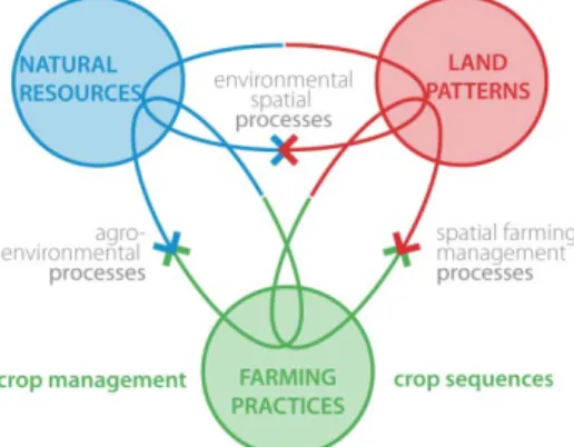
Figure 1 the landscape agronomy conceptual model for the agricultural landscapes. Adapted from Benoît et al. (under review).
2. The landscape management by farming systems
Following the recent evolution in agronomic research, Benoît et al. (under review) have proposed a conceptual model to approach agricultural landscape characterization, assessment and
modelling by focusing on the spatio-temporal processes that relate farming practices and natural (local) resources to land patterns (Fig. 1). In this perspective, landscape is assumed as a relevant context to deal with the holistic management of farming system, as recognized by some
agronomists so far (e.g. Deffontaines, 1973; Deffontaines et al., 1995; Cavazza, 1996; van Mansvelt, 1997; Mignolet, 2008; Osty et al., 2008; Primdahl and Kristensen, 2011). Nevertheless, during last decades agronomy seems to have dropped-off such perspective. The
contextualization of cultivated plots has been excessively neglected (cf. Nesme et al., 2010) as well as the explicit consideration of spatial dimensions of agricultural activities (White et al., 2002). Despite that, some authors have pointed-out the potential interest to regain, at least, a multi-scalar (Veldkamp et al., 2001; Dalgaard et al., 2003) or a cropping-system approach (Thenail et al., 2009; Leenhardt et al., 2010) in agronomy. In this direction, the farm is expected to be a
relevant level to articulate the field and the landscape management. For example, some studies have adopted the farm as perspective to analyse the strategic organization of farming practices over dispersed/multiple fields (Carsjens and van der Knaap, 2002; Morlon, 2005). Such approach focuses on the spatial relations of farming activities with the context in which they are performed. It follows that the farm level, coupled with the farmers’ decision making, could be a pivot in the multifunctional landscape design (Groot et al., 2010; Lovell et al., 2010; Primdahl and Kristensen, 2011). The increasing dispersion and interminglement of farm fields in the farming systems will eventually led to adopt the latter as relevant framework. In conclusion, we think that the agronomists’ specific competences on the major components of farming systems – namely farming practices and decision processes related to crop sequences and crop management – could shed new light on landscape changes and help elucidating landscape dynamics. This requires agronomists to go beyond the field boundaries (Hatfield, 2007; Rizzo, 2009; Lovell et al., 2010) by interfacing landscape and farming system management.
3. Articulating landscape and agricultural management units
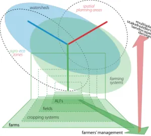
The conceptual model of the agricultural landscapes proposed by Benoît et al. (under review) reprised in Fig. 1 can help to explore how the landscape management by farming systems could be operationalized. Hereby we focus on main examples of land management units of rural areas. By land management units we mean a segmentation of rural spaces according to the variable geometries of management goals. Of note, the farmers’ practices could be targeted to several units below the overall farm level, like the agricultural landscape features, the fields, the cropping systems. These agricultural management units are embedded into wider levels like the farming systems, the watershed or other units defined by agro-eco zones or other kind of spatial planning areas. We have split these units in two groups: (1) the land units predominantly managed by farmers; (2) other land units where farmers act among a multitude of stakeholders (Fig. 2). Each type of these land management units could be referred to one of the three poles of the conceptual model showed in Fig. 1. At the same time, policy and design actions will target one of several of these units according to their objectives. For example, the preservation of freshwater quality could be targeted to the watershed management unit; however this objective will concern as well other overlaying units, like the local farming system, and the embedded units, like the agricultural ones. Similarly, the preservation of a traditional landscape character will affect a given rural space as well as the farming system that shapes it and its embedded land management units. The underpinning idea is that the agricultural management units represent the focal spatial objects for a multiple stakeholders’ design of agricultural landscape. In this context, agronomy could hence provide theory and methods to better integrate farming practices into the landscape planning policies and other territorial governance tools. In the next paragraphs, we discuss an example of the agricultural management units: the agricultural landscape features (hereafter ALFs) (section 3.1); then we detail the relation between the agricultural management units and an agronomic interpretation of the agricultural landscape patterns (section 3.2).
3.1 The ALFs as example of elementary agricultural management units
Among the land units chiefly managed by farmers, the ALFs could be identified as the elementary spatial object for the landscape management and design. In our perspective, however, their role in landscape design is justified only if they are related with the local context in which they are embedded and managed.
The ALFs include hedges, fences, drainages, permanent meadows, woodlots, farmsteads, and the wide array of buildings, linear networks and other elements supporting production activities or connecting agricultural fields to the environment. They fulfil specific management functions and
organize the space of the farms fields. For instance, ALFs mark the boundaries and regulate livestock movements (e.g. fences, walls), protect crops from wind or sun (e.g. hedges), regulate surface-water drainage (e.g. terraces), and so forth. In more general terms, they may be pointed-out as one of the most characterizing elements of the European agricultural landscapes
(Committee of Ministers, 2008; Palmieri et al., 2011). Therefore, ALFs are fundamental elements in the preservation of landscape character, thus they help fostering the main aim of the ELC (e.g. Groot et al., 2010; Kizos et al., 2010).
Figure 2. Diagram of the relations among major land management units in rural areas. ALFs = agricultural landscape features.
Frequently, ALFs have been shaped according to local ecological constraints/opportunities so they held a tight relation with natural resources. Their allocation and management trace the long evolution in the local ecological knowledge (UNCCD, 2005), especially in the case of the more permanent features, like networks of drainage or hedgerows (Deckers et al., 2005; Kizos et al., 2010; Bohan and Haughton, 2012). In this perspective, the ALFs support the characterization of recurring practices responding to permanent issues in the natural resources (e.g. water excess, predominant wind, profitable orientation, etc.), whereas the field patterns highlight the seasonal choices of farmers in response to transient issues in the local environment (e.g. an exceeding rainy season, a shortage in water availability, the arrival of new pests, etc.). Similarly, the spatial configurations and the characteristics of ALFs (e.g. the size of silage towers, the placement and size of barns, the type of irrigation devices, the size and the density of drainage ditches, etc.) permanently reflects temporary practices, otherwise difficult to be observed (e.g. silage, irrigation, etc.). Most of them may orient land use choice – so the cropping system dynamics – for instance by constraining the cultivated field size, its accessibility by machinery, or by influencing the crop allocation due to site-specific effects like shadowing or water retention (Thenail and Baudry, 2004; Marraccini, 2010). Actually, ALFs may also represent a constraint for the mechanized agricultural practices (e.g. ditch networks, terraces, hedges). For that, they were eventually altered or
removed during the 80s intensification of agriculture.
In the landscape agronomy perspective, the characterization of these various ALFs could be the entry point for the assessment of farming systems functioning and evolution. For example, Martin et al. (under review) have studied how farmers decide the allocation of new perennial biomass plots. The rules concerning the current or planned management of these ALFs have been related to the farm-level, where each farmer defines the farming practices according to technical,
economic and social factors. Then they have compared individual decision rules at the territorial level, thus providing relevant knowledge for the understanding of the spatial farming management processes.
3.2 Agronomic interpretation of the agricultural landscape patterns
Agricultural landscapes are the result of farming practices adapting natural resources in a process that continuously re-designs land patterns by farmer decisions. The LA perspective (Benoît et al., under review) underlines the centrality of farming practices in the characterization and assessment of these landscapes for the management of farming system and the landscape design. In Fig. 2 we have proposed a diagram of the main land units targeted by the farming management processes from a LA perspective. It is meant to explore the influence on agricultural landscape dynamics of two main decisions processes of farming practices: crop management and crop sequences (Fig. 1 and 3).
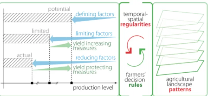
Figure 3. Landscape patterns. Adapted from van Ittersum and Rabbinge (1997).
Beyond the recurrent configurations of land management units in agricultural landscapes, agronomists can identify landscapes “regularities” governed by farmers’ decision rules (Fig. 3) as argued by Schaller et al. (2012). These configurations are determined by the recurring spatio-temporal combinations of crop sequences and crop management, which constitute what
agronomists call “cropping systems” (sensu Sebillotte, 1974). The shape and the frequency of the landscape patterns that one can observe in a given region will thus depend upon the farmers’ decision rules about those two elements (i.e. crop sequences and crop management).
Agricultural landscapes patterns may thus express the convergence of individual farming projects into recognizable spatio-temporal configuration of land units. In this way agronomists could upscale their perspective from the field and cropping-system management units toward the farming system. In terms of methods to identify landscapes “regularities”, the agro-physiognomic units appear as a promising approach because it integrates agricultural and morphological features with the cropping systems to finally define and assess agricultural management units (Deffontaines and Thinon 2001; Jacopin, 2011). Its rationale is to extend the wide agronomic knowledge about crop management and crop sequences on the overall farming system in a spatially explicit way. This would facilitate retrieving the basic agricultural landscape regularities as patterns of crops sequences and features that repeat regularly over time.
4. Conclusions: towards an interdisciplinary approach of agricultural landscapes The lack of interdisciplinary integration underlined for the whole landscape research (Pinto-Correia et al., 2006; Conrad et al., 2011) is even truer for agricultural landscapes, where a need for a greater integration of agronomy has been clearly pointed-out (Caron, 2005; Benoît et al., under review). In this paper we have focused on some challenges for the research on agricultural landscapes. The conceptual model recently proposed by the “landscape agronomy” perspective
has been here extended to enhance the landscape management by farming systems. On these bases, we finally focus on agro-ecology, geo-agronomy and landscape ecology as three relevant examples that could help fostering a more integrated approach to the study and the management of agricultural landscapes.
Agro-ecology is developing interesting methods for the agroecosystem design, focused either on landscape feature or on the cropping system land units. It fosters a scalar and multi-disciplinary approach to the cropping system management (Dalgaard et al., 2003). On these bases, Moonen and Bàrberi (2008) have called upon scientists to enhance bridges between agronomy and ecology by a more systematic application of the agro-ecosystem approach in the study of relationships between agriculture and biodiversity. Nevertheless, wide room remains for interaction with human sciences (Dalgaard et al., 2003); moreover the practical applications for temperate landscapes management are still too limited (Lovell et al., 2010).
Geoagronomy pursues the spatially explicit approach of agronomy. It integrates the theories and methods of agronomy and geography to explain the role of farming in landscape structures and dynamics as well as studying the spatial configuration of farming systems (Deffontaines 1991; Deffontaines et al. 1995). From a geographer’s point of view, there could be a more structured cooperation with agronomy to articulate socio-spatial dimensions of farmed land management and planning (Gulinck and Wagendorp 2002; Valbuena et al. 2010; Primdahl and Kristensen, 2011). The issue at stake is to understand how processes of change are linked to place-based demands (Musacchio, 2011), by enhancing geographic methods in the spatialization of the agronomic process of knowledge production (Lovell et al., 2010).
Landscape ecology is probably the most advanced basis of integration in landscape research. Generally speaking, it analyses landscape as non-random aggregation of patch governed by processes and patterns, to interpret the former and to manage the latter (Farina, 2000).
Agronomy could improve this well established framework by providing ecologists with knowledge on farmers’ decision-making processes for combining production management and landscape (services) management (e.g. Lovell et al., 2010), or on the evaluation of the related public goods and ecosystem services, like in the case of species conservation (e.g. Lazrak et al. 2010). In conclusion, we recall that farmers’ choices respond to the global project they have on their farm management, which may not depend only on production goals. Furthermore their projects foster the integration in local and/or global production chains. By developing the landscape agronomy model of agricultural landscapes we have represented the link of the agricultural management units (ALFs, fields, etc.) with the farm they belong to and, behind that, with the wider land units where different management units are integrated. We argue that such perspective could allow to study some of the main rural spaces composing the agricultural landscapes, in order to discuss the role of farming systems as an interdisciplinary research object for landscape management issues.
References
Benoît, M., Rizzo, D., Marraccini, E., Moonen, A.C., Galli, M., Lardon, S., Rapey, H., Thenail, C., Bonari, E. Landscape agronomy: a new perspective for research on agricultural landscapes. Landscape Ecology (under review).
Bohan, D.A., Haughton, A.J. (2012). Effects of local landscape richness on in-field weed metrics across the Great Britain scale. Agric. Ecosyst. Environ. doi: 10.1016/j.agee.2012.03.010. Caron, P. (2005). What kind of territories are agronomists interested in? A tropical geographer’s
Carsjens, G.J., van der Knaap, W. (2002). Strategic land-use allocation: dealing with spatial relationships and fragmentation of agriculture. Landscape and Urban Planning 58(2-4): 171– 179.
Cavazza, L. (1996). Agronomia aziendale e agronomia del territorio. Riv. Agron 30(3): 310–319. COE – Council of Europe (2000). European Landscape Convention, Council of Europe Treaty
Series n. 176.
Committee of Ministers (2008). Recommendation of the Committee of Ministers to member states on the guidelines for the implementation of the European Landscape Convention.
Conrad, E., Christie, M., Fazey, I. (2011). Is research keeping up with changes in landscape policy? A review of the literature. Journal of Environmental Management 92(9): 2097–2108. Dalgaard, T., Hutchings, N.J., Porter, J.R. (2003). Agroecology, scaling and interdisciplinarity.
Agriculture, Ecosystems & Environment 100(1): 39–51.
Deckers, B., Kerselaers, E., Gulinck, H., Muys, B. (2005). Long-term spatio-temporal dynamics of a hedgerow network landscape in Flanders, Belgium. Envir Conserv 32(1):20–29.
Deffontaines, J-P. (1973). Analyse du paysage et étude régionale des systèmes de production agricole. Économie rurale 98(1): 3–13.
Deffontaines, J.P. (1991). L’agronomie, science du champ. Le champ, lieu d’interdisciplinarité: de l’écophysiologie aux sciences humaines. Agronomie 11(7): 581–591.
Deffontaines, J-P., Thenail, C., Baudry, J. (1995). Agricultural systems and landscape patterns: how can we build a relationship? Landscape and Urban Planning 31(1-3): 3-10.
Deffontaines, J.-P., Thinon, P. (2001). Des entités spatiales significatives pour l’activité agricole et pour les enjeux environnementaux et paysagers contribution à une agronomie du territoire. Courrier de l’Environnement de l’INRA 44: 12–27.
FAOSTAT (2009). Available online at faostat.fao.org/site/377/DesktopDefault.aspx?PageID=377 Farina, A., 2000. Landscape ecology in action. Doredrecht, Kluwer Academic Publishers. Groot, J.C.J., Jellema, A., Rossing, W.A.H. (2010). Designing a hedgerow network in a
multifunctional agricultural landscape: Balancing trade-offs among ecological quality, landscape character and implementation costs. European Journal of Agronomy 32(1):112– 119.
Gulinck, H., Wagendorp, T. (2002). References for fragmentation analysis of the rural matrix in cultural landscapes. Landscape and Urban Planning 58(2-4): 137–146.
Hatfield, J.L. (2007). Beyond the Edge of the Field. Available at :
https://www.agronomy.org/about-society/presidents-message/archive/13. Accessed 7 Oct 2011
Jacopin, R. (2011). Paysages et pratiques des agriculteurs dans le Sud du Plateau Lorrain: logiques d’organisation et effetc sur l’environnement. PhD thesis. Nancy, Université Nancy 2.
Jones, M., Howard, P., Olwig, K.R., Primdahl, J., Sarlöv Herlin, I. (2007). Multiple interfaces of the European Landscape Convention. Norsk Geografisk Tidsskrift - Norwegian Journal of Geography 61(4): 207–216.
Kizos, T., Koulouri, M., Vakoufaris, H., Psarrou, M. (2010). Preserving Characteristics of the Agricultural Landscape through Agri-Environmental Policies: The Case of Cultivation Terraces in Greece. Landscape Research 35(6): 577–593.
Lazrak, E.G., Mari, J.-F., Benoît, M. (2010). Landscape regularity modelling for environmental challenges in agriculture. Landscape Ecology 25(2): 169–183.
Leenhardt, D., Angevin, F., Biarnès, A., Colbach, N., Mignolet, C. (2010). Describing and locating cropping systems on a regional scale. A review. Agronomy for Sust. Develop. 30(1): 131-138.
Lovell, S.T., DeSantis, S., Nathan, C.A., Olson, M.B., Ernesto Méndez, V., Kominami, H.C., Erickson, D.L., Morris, K.S., Morris, W.B. (2010). Integrating agroecology and landscape multifunctionality in Vermont: An evolving framework to evaluate the design of
agroecosystems. Agricultural Systems 103(5): 327–341.
Marraccini, E. (2010). La valutazione delle funzioni agro-ambientali: un approccio agronomico-territoriale. PhD thesis. Paris, AgroParisTech, and Pisa, Scuola Superiore Sant'Anna. Martin, L., Wohlfahrt, J., Le Ber, F., Benoît, M. Perennial biomass crops allocation: a French case
study regarding miscanthus. L’Espace géographique (under review).
Mignolet, C., 2008. Modélisation de l’organisation spatiale des systèmes agricoles et de son évolution dans des démarches d’appui au développement. PhD thesis. Paris,
AgroParisTech.
Moonen, A.C., Bàrberi, P. (2008). Functional biodiversity: An agroecosystem approach. Agric. Ecosyst. Environ. 127(1-2): 7–21.
Morlon, P. (2005). La dimension spatiale des pratiques agricoles: une approche agronomique. In Agricultures et territoires. C. Laurent and P. Thinon. Paris, Hermes-Lavoisier: 175–190. Musacchio, L.R. (2010). The grand challenge to operationalize landscape sustainability and the
design-in-science paradigm. Landscape Ecol 26(1): 1–5.
Nesme, T., Lescourret, F., Bellon, S., Habib, R. (2010). Is the plot concept an obstacle in
agricultural sciences? A review focussing on fruit production. Agric. Ecosyst. Environ. 138(3-4): 133–138.
Osty, PL., Le Ber, F., Lieber, J. (2008). Raisonnement à partir de cas et agronomie des territoires. Revue d’anthropologie des connaissances 2(2):169–193.
Palmieri, A., Dominici, P., Kasanko, M., Martino, L. (2011). Diversified landscape structure in the EU Member States. EUROSTAT. Statistics in focus. General and regional statistics 21:1-12. Pinto-Correia, T., Gustavsson, R., Pirnat, J. (2006). Bridging the Gap between Centrally Defined
Policies and Local Decisions – Towards more Sensitive and Creative Rural Landscape Management. Landscape Ecology 21(3): 333–346.
Primdahl, J., Kristensen, L.S. (2011). The farmer as a landscape manager: Management roles and change patterns in a Danish region. Geografisk Tidsskrift-Danish Journal of Geography 111(2): 107–116.
Rizzo, D. (2009). Landscape-agronomic analysis in the agro-environmental fragility assessment of a terraced landscape. PhD thesis. Pisa, Scuola Superiore Sant’Anna.
Schaller, N., Lazrak, E.G., Martin, P., Mari, J.-F., Aubry, C., Benoît, M. (2012). Combining farmers’ decision rules and landscape stochastic regularities for landscape modelling. Landscape Ecology 27(3): 433–446.
Sebillotte, M. (1974) Agronomie et agriculture. Essai d’analyse des tâches de l’agronome. Cah Orstom (Sci Hum) 24:3–25.
Thenail, C., Baudry, J. (2005). Farm riparian land use and management: Driving factors and tensions between technical and ecological functions. Environm. Management 36(5):640– 653.
Thenail, C., Joannon, A., Capitaine, M., Souchère, V., Mignolet, C., Schermann, N., Di Pietro, F., Pons, Y., Gaucherel, C., Viaud, V., Baudry, J. (2009). The contribution of crop-rotation organization in farms to crop-mosaic patterning at local landscape scales. Agric. Ecosyst. Environ. 131(3-4): 207–219.
UNCCD – United Nations Convention to Combat Desertification. (2005) Promotion of traditional knowledge : a compilation of UNCCD documents and reports from 1997-2003. Bonn, United Nations Convention to Combat Desertification.
Valbuena, D., Verburg, P.H., Veldkamp, A., Bregt, A.K., Ligtenberg, A. (2010). Effects of farmers’ decisions on the landscape structure of a Dutch rural region: An agent-based approach. Landscape and Urban Planning 97(2): 98–110.
van Ittersum, M.K., Rabbinge, R. (1997). Concepts in production ecology for analysis and quantification of agricultural input-output combinations. Field Crops Research 52(3): 197– 208.
van Mansvelt, J.D. (1997). An interdisciplinary approach to integrate a range of agro-landscape values as proposed by representatives of various disciplines. Agric Ecosyst Environ 63(2-3): 233–250.
Veldkamp, A., Kok, K., De Koning, G.H.J., Schoorl, J.M., Sonneveld, M.P.W., Verburg, P.H. (2001). Multi-scale system approaches in agronomic research at the landscape level. Soil and Tillage Research 58(3-4): 129–140.
White, J.W., Corbett, J.D., Dobermann, A. (2002). Insufficient geographic characterization and analysis in the planning, execution and dissemination of agronomic research? Field crops research 76(1): 45–54.