HAL Id: hal-02658914
https://hal.inrae.fr/hal-02658914
Submitted on 30 May 2020
HAL is a multi-disciplinary open access
archive for the deposit and dissemination of
sci-entific research documents, whether they are
pub-lished or not. The documents may come from
teaching and research institutions in France or
abroad, or from public or private research centers.
L’archive ouverte pluridisciplinaire HAL, est
destinée au dépôt et à la diffusion de documents
scientifiques de niveau recherche, publiés ou non,
émanant des établissements d’enseignement et de
recherche français ou étrangers, des laboratoires
publics ou privés.
To cite this version:
Ophélie Robineau, Martin Châtelet, Christophe-Toussaint Soulard, Isabelle Michel-Dounias, Joshua
Posner. Integrating farming and páramo conservation: A case study from Colombia. Mountain
Research and Development, International Mountain Society, 2010, 30 (3), pp.212-221.
�10.1659/MRD-JOURNAL-D-10-00048.1�. �hal-02658914�
Integrating Farming and Pa
´ramo Conservation:
A Case Study From Colombia
Ophe´lie Robineau1*, Martin Chaˆtelet1*, Christophe-Toussaint Soulard2, Isabelle Michel-Dounias1,2, and Joshua Posner3 * Corresponding authors: [email protected]; [email protected]
1Institut des Re´gions Chaudes (Supagro University Institute), 1101 Avenue Agropolis, BP 5098, 34093 Montpellier Cedex 05, France 2
INRA UMR 951 Innovation, Campus de la Gaillarde, 2 Place Viala, 34060 Montpellier Cedex 1, France
3Department of Agronomy, University of Wisconsin, 1575 Linden Drive, Madison, USA
Open access article: please credit the authors and the full source.
The Colombian
environmental policy voted in 1993, which aimed to strengthen the protection of natural resources, particularly biodiversity and water, is totally unfavorable to farming in the strategic pa´ramo ecosystem. However, many rural development practitioners and researchers believe that integrated management of the pa´ramo is possible and that farming activities can be part of the solution along this agriculture–conservation frontier. This issue has become particularly acute on the Rabanal pa´ramo (western cordillera), in Colombia, where the projected expansion of a core protection zone will soon include major areas currently used for agriculture and settlements. Although small-scale farmers have been living there for decades, the environmental authorities are intent on prohibiting farming activities in the entire protection area. A
study of local history and aerial photos indicates that this zone has been a dynamic part of local farming systems since at least the 1950s and that the pa´ramo has evolved from a
subsistence farming area to a zone that now includes intensive potato production conducted by external entrepreneurs. The presence of these entrepreneurs is mainly due to small-scale farmers’ need for a cost-effective solution to maintain the productivity of their pastures. By interviewing participants in the debate, as well as by mapping agricultural land that will soon be included in the protected area, objectives for action were developed that would result in more sustainable farming practices, thus enhancing the conservation of pa´ramo biodiversity and water resources.
Keywords: Farming systems; geo-agronomy; buffer zone management; water resource conservation; biodiversity conservation; farmer typology; typology of parcel management; Colombia.
Peer-reviewed: June 2010 Accepted: June 2010
Conservation of pa
´ramo biodiversity and water
resources: a central issue in the Andes
Protected areas, such as national parks and reserves, now cover more than 12% of the world’s land area (Chape et al 2003). However, as the United Nations–convened Rio conference highlighted, because of the failures of strict protection policies, it is crucial to have close links between environmental and development policies (IUCN/ UNEP/WWF 1991). Nevertheless, the ‘‘protection versus development’’ viewpoint remains a contentious element in the establishment of protected areas (He´ritier 2007). This is not surprising, because integrated landscape planning, making specific choices about land use, wildlife protection, and resource development that are acceptable to communities and conservation authorities, remains a difficult task (Slocombe 1993, Galvin and Haller 2008).
In this context, the Andean pa´ramo, a unique mountain grassland ecosystem with distinct and very diverse fauna and flora (Churio 2006), located between the upper forest line (about 3000 m) and the permanent snow line (about 5000 m), is at a crossroads. Although protection of the pa´ramo is playing a more valuable role in biodiversity
conservation, water regulation, and carbon storage (Van der Hammen 2002), there is increasing demand from urban centers for potato and milk production (Figure 1). For decades, in most Colombian pa´ramos, potato and dual-purpose cattle (meat and milk) production were the mainstay of family farms. More recently, an alternative system has expanded, with land being rented for a year for capital-intensive potato production followed by several years of grazing, which results in more pa´ramo land being put under cultivation. However, this model of potato production is in direct confrontation with the national environmental policy. Indeed, the use of agrochemical inputs and the aggressive means of soil tillage linked with capital-intensive potato production run counter to the will to protect pa´ramo biodiversity and water resources. Increasingly, the policy is unfavorable to farming in this ecosystem and is centered on the creation of protected areas free from productive activities.
In the tropical Andes, many researchers have focused on the ecology of these high-altitude tropical grasslands and on human-induced ecological effects on them (Etter and Villa 2000; Cardenas and Vargas 2008). Hofstede (1995) has shown that the combination of grazing and
MountainDevelopment Transformation knowledge Mountain Research and Development (MRD)
An international, peer-reviewed open access journal published by the International Mountain Society (IMS) www.mrd-journal.org
burning reduces soil organic matter levels and increases soil bulk density, which markedly reduces soil water retention capacity. More recently, other studies have been conducted to characterize the agricultural and settlement frontiers, which focused on socioeconomic aspects, hence providing new perspectives for integrated management of this fragile ecosystem. Lo´pez Sandoval (2004), working in the Ecuadorian pa´ramo, highlighted the complex reasons for expanding or stabilizing agricultural pioneer zones. Llambi et al (2005), working in the Venezuelan pa´ramo, reported on the necessary implementation of
participatory planning to improve the conservation of the pa´ramo ecosystem by incorporating local communities in land-planning exercises, which requires a deep
understanding of pa´ramo users’ objectives (particularly those of farmers) alongside environmental objectives. In Colombia, however, little information is available to date on how to combine farmers’ and environmental
objectives.
The aim of the field research presented in this article, by using the specifics of 1 case study site, was to
investigate how detailed information on the farming system can foster mutual understanding between local communities and environmental authorities, and facilitate negotiations between these 2 groups. The research relied on the hypothesis that, to enhance dialogue between farmers and institutions, it is necessary to give farmers’ objectives and strategies due
consideration. An analysis of the local farming systems was undertaken to highlight the drivers of land use changes and to identify options for allowing farmers to remain in the pa´ramo while simultaneously meeting environmental objectives.
Material and Methods
Study site: the Rabanal pa´ramo in Colombia
The Rabanal pa´ramo is a key study area of the Andean Pa´ramo Project. The Rabanal pa´ramo is located 100 km north of Bogota´ (5u24900N; 73u36900W). It was chosen for inclusion in the project in part because the core
protected area had been expanded from 2681 ha to 8600 ha in 2008 (IAvH2008), which would markedly affect pa´ramo land management and local incomes in the villages that surround the zone. In all, more than 1500 ha of cultivated land will soon be included in the protected area.
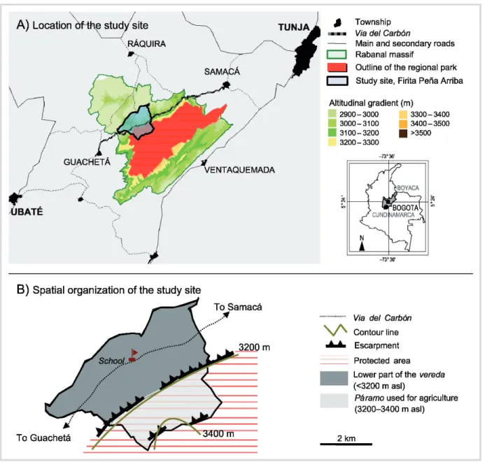
This study was conducted in the hamlet of Firita Pen˜a Arriba, which belongs to the township of Ra´quira (Figure 2). It includes an area of 1331 ha, of which 560 ha are now designated as part of the protected area outlined by the Rabanal management plan (IAvH2008). The zone is divided into 2 parts:
1. A lower hilly part (below 3200 m), home to 90% of the 434 hamlet’s inhabitants, including most of the village infrastructure, services, and 27 coal mines.
2. The pa´ramo area (about 560 ha, above 3200 m) and home to 10% of the population. This is the focal area of the study (Figure 2).
An in-depth analysis of small-scale farmers’ strategies and objectives
A 3-step analysis approach that combines agronomy, geography, and management sciences was used. The aim was to identify possibilities for introducing technical and
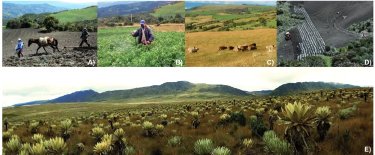
FIGURE 1 (A) Small-scale farmers planting potatoes; (B) a farmer spraying a potato field; (C) sheep on the pa´ ramo used for agriculture; (D) entrepreneur planting potatoes; (E) herbaceous pa´ ramo. (Photos by Martin Chaˆtelet and Ophe´lie Robineau)
organizational changes that would foster the integration of conservation of pa´ramo biodiversity and water resources with sustainable livelihoods.
The core of the research was a spatiotemporal analysis of farming activities to understand the logic of land use, that is, why and how farmers use pa´ramo land. Spatial and temporal scales were considered, from the pa´ramo to the cultivated parcel, and from the daily management of farming activities to the life cycle of a farm.
N
The first step consisted of key informant interviews,with the objective of understanding the forces driving
land use changes on the Rabanal pa´ramo from the parcel scale to the whole pa´ramo area used for agriculture. A focus was made on the agrarian history of the study area. In parallel, geographical data in the form of aerial photos (Instituto Geogra´fico Agustin Codazzi, 1:24,000 scale, 1955, 1985, 2007) was gathered to identify the changes that had occurred in the pa´ramo landscape.
N
The second step was devoted to in-depth interviewswith pa´ramo farmers to understand the range of farm diversity and dynamics. Elements of the farming systems, notably the decision-making process for
FIGURE 2 Location and spatial organization of the study site Firita Pen˜a Arriba. (Graphic design by Martin Chaˆtelet and Ophe´ lie Robineau)
MountainDevelopment
potato production, herd and pasture management, and economic data, were collected by using semistructured interviews. A typology of farmers was built, based on the strategies and objectives of the pa´ramo agricultural users.
N
The third step was the identification of farmers’ roomfor maneuver in implementing more environmentally friendly farming practices. With the aid of a geo-graphic positioning system, pa´ramo fields were identi-fied and mapped. A typology of parcels was built, based on the logic of land use, which corresponds to a theoretical model of land occupation. Indeed, farmers manage their parcels differently, depending on loca-tion and characteristics (size, slope, land tenure), and it was possible to build a typology for parcel manage-ment. Propositions for modified land use that fit both the typology of parcels and farmers’ strategies were then developed.
Of the 35 users of the contested 506 ha of pa´ramo, 23 participated in intensive interviewing (each interview lasted for 2–4 hours, most participants were
reinterviewed up to 3 times). It took a team of 2 people a period of 6 months (May to October 2009) to collect the necessary information.
A brief history of agricultural use of the pa
´ramo
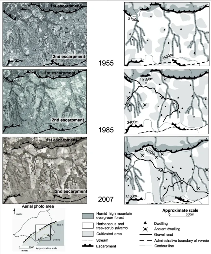
In the 1950s, the pa´ramo landscape of Firita Pen˜a Arriba consisted of a mosaic of agricultural parcels within the native pa´ramo vegetation. Contrary to the advance of a well-delineated altitudinal frontier observed by Lo´pez Sandoval (2004) in her study in Ecuador, in Firita Pen˜a Arriba, there does not appear to have been an altitudinal pioneer frontier; rather, the cultivated and grazed area within the already colonized pa´ramo expanded over time (Figure 3).
The farm territories were organized into 2 sites, in the upper and lower part of the hamlet, so to take advantage of the Andean verticality to diversify agricultural production (Figure 2B). The cultivated area did not exceed 1 ha on the farms. Family farmers mainly grew tubers on plots tilled by animal traction, with the help of children who would eventually inherit the farms.
This traditional scheme was modified in the 1960s with the departure of many of the younger generation to the lower part of the hamlet to work in the newly opened mines and to the cities. Today there are 133 coal mines and 772 coke ovens in the region (IAvH2008). As a result of these employment opportunities, and migration to urban centers, today nearly 40% of the pa´ramo land is in the hands of absentee owners and miners, some of whom rent their land to the remaining family farmers, and others have developed low labor-intensive animal production to complement their nonfarm income.
As a partial response to the loss of workforce, small-scale farmers started to put more emphasis on milk
production and purchased Normandy dual-purpose cattle in the 1970s. As demand for dairy products increased with an increasingly urban population, the government made efforts to spread these breeds in Colombia. Livestock keeping requires less labor than potato production (the cattle are managed year round on meadows), and livestock keeping has progressively become the main source of income, thus replacing tuber production as the main source of revenue. This shift also coincided with increasing use of agrochemical inputs (especially fertilizer) on potatoes, which enabled farmers to maintain, or even to increase, their tuber production, despite a reduction in the area cultivated.
However, the dairy cows in the herd required higher-quality feed; this is primarily found in new-growth pasture after potato production, and the maintenance of the forage quality of the pastures gradually became problematical. With up to 5 milking cows and their progeny, family farmers did not have enough higher-quality pasture for their dairy animals. In the 1980s, a new solution presented itself. With the arrival of the
Guatemalan potato moth (Tecia solanivora) in Colombia, agricultural entrepreneurs from the plains began looking for cooler land in the pa´ramo to rent, with fewer pest problems, to produce potatoes on a large scale. Small-scale farmers in the pa´ramo started to rent out parcels to these commercial potato growers as a way to solve their forage quality problems. Initially, they benefited from the entrepreneurs’ tractors to clear the rest of pa´ramo vegetation on their farm to create more meadows. Nowadays, on a more regular basis, their pastures benefit from the tillage and residual effect of fertilizer inputs associated with this intensive large-scale potato
production. Almost all their plots are part of the potato– pastures crop rotation: 1 year of potato (2 cycles) followed by 3 years of pasture. The logic of this rotation is (1) to benefit from the positive carry-over effect of potato production on pasture productivity and (2) to maintain a period of time between replanting potatoes on the same plot so to lower the pressure of soil-borne pests and diseases.
In 1993, law 99 was ratified (National decree 1713 of 2002). It affirmed the national will to follow the principle of sustainable development and reinforced the laws that govern management of natural resources and, more particularly, of pa´ramo ecosystems. The country’s
biodiversity, considered as a national patrimony, was also considered as a priority for the common good. In the whole country, management plans were designed for all the strategic ecosystems to improve their protection. On the pa´ramos, these plans have gone together with the design of protected areas free from productive activities so to protect both biodiversity and water resources. Because of an increased focus on the role played by the Rabanal pa´ramo in potable and irrigation water
FIGURE 3 Evolution of the agricultural frontier over time in Firita Pen˜a Arriba (based on an aerial photo interpretation and on-the-ground mapping). (Graphic design by Martin Chaˆtelet and Ophe´ lie Robineau)
MountainDevelopment
environmental authorities threatened pa´ramo farmers with fines for the land they had cleared. This strategy of the environmental authorities backfired, and some farmers, afraid of losing their farmland still covered by pa´ramo vegetation, quickly cleared it to affirm their property rights.
Results of farming systems’ analysis
Small-scale farmers: key managers of the pa´ramo
Based on the surveys and farm mapping, 3 general types of pa´ramo agricultural users were identified with different short- and long-term objectives that generate distinct impacts on the natural resource base:
1. Small-scale farmers of the pa´ramo, 2. Miners and absentee land owners,
3. Entrepreneurs (commercial potato growers) from the plains.
It is estimated that small-scale farmers manage approximately 60% of the pa´ramo because of the land they own and rent on a long-term basis from absentee owners. In addition, about 75% of the 80 to 120 ha rented out yearly to the commercial potato growers comes from the small-scale farms. For this reason, small-scale farmers are strategic actors in the management of the pa´ramo.
Potato and dual-purpose cattle production: 2 complementary farming activities
Small-scale farmers in the pa´ramo live exclusively from farming activities and have farms of about 20 ha. Based on the household budgets of 10 families, we estimated that their income is about US$ 150/mo, well below the Colombian minimum wage (US$ 230/mo, Decree 4965 of 27-12-2007). The main economic activities of small-scale farmers are dual-purpose cattle and potato production, which contribute 60% of their income for cattle and 25% for potato; 9% of their income comes from subsistence crops (maize, Andean tubers, and broad beans) and 6% comes from land rental.
These farmers generally keep 10 to 12 head of cattle, of which 5 are milking cows, and up to two thirds of the 20 ha of the farm are devoted to grazing each year. The main constraint faced by small-scale farmers of the pa´ramo is the difficulty of maintaining forage productivity. They find that pastures need to be fertilized every 3 to 4 years, otherwise, pasture quality declines and affects dairy production. But, because of the small surface that farmers can cultivate in annual crops each year (rarely more than 0.2 ha because of the high costs of production), they are not able to renew the pastures as rapidly as they feel is necessary. Furthermore, they do not have the means to pay for directly fertilizing the pastures. To compensate for this, 5 to 7 ha of farmers’ land is rented out yearly to be planted by commercial potato growers.
These data suggest that the more important advantage of land rental is not the rental income itself, but the positive impact of associated tillage and fertilizer additions on subsequent forage productivity and quality. Indeed, land rental helps to support livestock production, which has become the main economic activity on the farms. Small-scale livestock production is closely linked with large-scale potato production, which constitutes the main activity targeted by the environmental authorities.
Potatoes are primarily cultivated in the pa´ramo area, rather than in the lower village because of the pa´ramo’s larger fields and flatter terrain. At the lower site, parcels are sloping and rocky, which make cultivation and pasture renovation difficult. Currently, for 100 kg of tubers planted, which corresponds to 1000 m2, 200 kg of chemical fertilizer, 200 kg of lime, and 500 kg of poultry droppings are spread. Farmers consider it essential to apply these quantities to ensure a minimum economic yield (25 t/ha on commercial fields and 20 t/ha in farmers’ fields). They adhere to a systematic treatment regime. Because growing potatoes is costly and risky, the farmers do not want to take the risk of losing their production because of insufficient soil nutrients and pest and disease incidence.
Somewhat surprisingly, small-scale farmers on their small potato plots follow nearly the same input schedule and the same cropping calendar, and apply the same proportions of agrochemicals that commercial potato growers do. They also do the soil tilling by tractor. However, the real difference lies in the production scale: although small-scale potato production occurs annually on less than 5% of the future protected area, up to 25% of this soon to be core area is annually cultivated by the commercial potato growers.
Dual-purpose cattle and potato productions are 2 complementary sources of income and are essential to balancing the family budget; whereas, the regular sale of livestock products provides for basic daily needs, family potato production brings more money immediately and allows investments to be made.
Starting point for designing localized integrated
management strategies: a typology of
parcel management
The underlying logic of land use is related to the parcels’ characteristics, the spatial organization of the farm territory, and the system of land tenure. A classification of fields was made according to the way farmers manage their parcels to enable a spatial approach of the environmental impact of agriculture. Mapping this typology enables one to visualize the overlapping of crucial environmental issues (eg protection of wetlands, of plots with endemic species) and to locate farming practices unfavorable to the conservation of natural
resources (eg application of agrochemical inputs on potatoes near or on a wetland, tillage of plots of spontaneous vegetation). Thus, mapping is a good basis for initiating a discussion among the stakeholders, formulating specific problems to be tackled, and starting negotiations. It was thought that this would be an important input to the process of designing new practices that result from a compromise between the current constraints encountered by agricultural users and the expectations of environmental authorities.
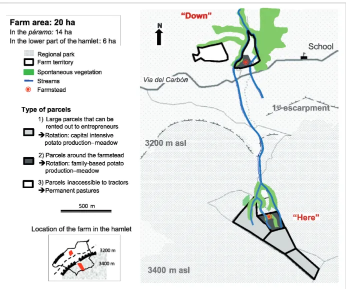
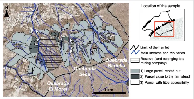
The 3 types of land-use parcels and their management (Figure 4) are:
1. Large (3 to 8 ha) relatively flat parcels that are used for grazing for 3 years and then rented out to commercial potato growers for a year (this kind of parcel
represents more than 85% of the 560 ha soon to be incorporated into the core area). From the small-scale farmers’ point of view, a key issue in reducing large-scale potato production on these parcels would be in finding alternatives to restore their pastures. The low stocking rate, which does not exceed 1 animal unit per hectare, suggests that there are possibilities of land intensification in the livestock system.
2. Parcels around the farmsteads where the restoration of pastures follows family potato production (this kind of parcel represents 10% of the core area). Because potato production is important to the household economy, on this relatively small area, sustainable management practices for potato production could be promoted. Reducing both the costs of production and the impact of potato growing on natural resources,
FIGURE 4 Example of the territorial organization of a family farm in Firita Pen˜a Arriba. (Graphic design by Martin Chaˆtelet and Ophe´lie Robineau)
MountainDevelopment
through reduction of the use of agrochemical inputs and promotion of less-intensive tillage practices, would fit both environmental authorities’ and farmers’ objectives.
3. Parcels inaccessible to tractors, where the pastures are not renovated (only 1% of the area). On these areas left as permanent grazing, a compromise could be found between letting the spontaneous vegetation grow again and controlling the grazing so as to keep plots of spontaneous pa´ramo vegetation within the farms.
The 3 kinds of parcels were mapped at the pa´ramo scale in the study area (Figure 5), which allows us to consider the potential role of farming practices in having a negative impact on natural resources according to the pattern of these 3 field types at the landscape level. With the priority of improving integrated management of natural resources, one can then identify actions according to the characteristics of the individual site. For example, in the Quebrada Baricha sector (Figure 5), where mostly parcels of type 3 are found; a third of the site is
exclusively under intensive potato production each year, which means that the impact of farming activities might be greater in terms of water contamination. Moreover, parcel configuration (large parcels without obstacles) is unfavorable to the maintenance of ecological corridors and hence to the maintenance of pa´ramo biodiversity within the area used for agriculture.
Future prospects and discussion
One can imagine 3 scenarios over the next decade: 1. Environmental legislation is strictly enforced, which
would eventually lead to the disappearance of small-scale farming in the area because a reallocation of activities to the lower part of the hamlet is not possible due to small holding and rough terrain;
2. Environmental legislation is not enforced, so the current dynamics would continue, which results in an increasing percentage of absentee land owners and commercial potato growers on the pa´ramo, because only a few new small-scale farmers would settle there; or 3. Small-scale farming is supported with the objective of
enhancing farmers’ incomes and improving their integration with the pa´ramo environment. To see the third scenario happen and to build a consensus around protecting the pa´ramo, negotiations among the stakeholders, support to village organizations, and research are essential.
The geographical approach to farming practices, with its spatial configuration of farming activities, highlights the logic of land use in a space and time perspective, evaluating the impact of farming activities on the environment according to the location of farming activities. However, it allows one to link land use to the farm level, which is where these decisions are taken (Soulard 2005).
FIGURE 5 Extension of the typology of parcels to the scale of the study area. (Graphic design by Martin Chaˆtelet and Ophe´lie Robineau)
The methodology used in this research provides valuable inputs to stimulate dialogue among the different stakeholders of the pa´ramo’s management and to initiate a negotiation process. The results would enable the environmental authorities to better identify the constraints that lead farmers to adopt unsustainable practices and thus to consider the root problem to be tackled, rather than adopt a strict position where any activity is prohibited on the pa´ramo.
Results from our case study were discussed with farmers in the neighboring hamlets, who generally received them positively. To achieve integrated management of the pa´ramo, similar studies should be conducted in the other hamlets included in the extension of the protection area. Then multistakeholder platforms could be implemented with the different actors
concerned by land use planning, both at the hamlet and at the pa´ramo scale. Until now, farmers have been excluded from conservation planning. Opening discussion and promoting farm visits with farmers and environmental authorities to have an exchange about conservation issues would improve mutual understanding of each other’s objectives, expectations, and constraints. The inclusive design of solutions that suit farmers’ strategies and help them to live better on farming activities might then induce a change in farmers’ behavior.
However, for this work to be complete and for all the necessary inputs to go to the negotiation table,
information is needed on the hydrology of the 3 microwatersheds (Quebradas) outlined in Figure 5, as well as on the distribution of key pa´ramo plant communities. Then, with the environmental and farming systems information available, the actors (especially small-scale farmers, commercial potato growers, environmental authorities, and research institutes) could join at the table to discuss a micromanagement plan for the different zones. Some of the elements of the compromise will be the following:
N
Developing improved pasture management techniques.Although it remains a difficult task to improve pasture management in an ecologically and economically wise manner (Hofstede 1995), alternative methods of pasture restoration without frequent tillage and heavy fertil-ization would have to be identified, as well as grazing management patterns that protect particularly fragile landscapes and maintain pa´ramo biodiversity.
N
Using less chemical inputs. There are discrepanciesbetween actual and recommended practices for potato cultivation (it has been estimated that farmers apply 3 times more nitrogen than recommended by the Secretary of Agricultural and Rural Development of Cundinamarca). Along with efforts to apply best management practices on small-scale farmers’ potato plots, hydrological monitoring could take place to estimate the impact of farming practices on surface water quality, by comparing the 3 microwatersheds in Figure 5 (Quebradas El Moral, Seca, and Baricha). This would provide a basis to determine the level of contamination of the streams and the source of contamination, to target the farming practices in-volved, and to identify margins of progress that could be reached to lower the impact of farming activities on water quality.
N
Setting aside key landscape areas (for conservation ofbiodiversity and water resources), and establishing buffer strips between pastures and potato fields and stream channels. These would protect the streams from both animal excrement and agrochemical residue and would make it possible to keep ecological corridors within and between the farms, thus participating in the maintenance of pa´ramo biodiversity.
The case studied here illustrates a situation found elsewhere in the Andes, where high input potato
production is taking place on the pa´ramo, thus impacting on the maintenance of the pa´ramo’s biodiversity and on water quality. Moreover, with a warming climate, it is likely that this type of farming will be possible at higher elevations. In other Colombian and Venezuelan pilot sites of the Andean Pa´ramo Project, the link between potato and livestock production has been observed, raising the same environmental issues.
The Venezuelan agents of the Andean Pa´ramo Project highlighted the importance of building a consensus among the different participants included in the establishment of a protected area (Yerena et al 2003) to involve them in the participatory process, from project presentation to the technical evaluation of the action plan designed. Moreover, an integration of spatial scales and disciplines to highlight the links between farmers’ strategies, environmental and agricultural policies, and biophysical and socioeconomic environments makes improvements in the integrated management of natural resources possible (Castella 2005).
ACKNOWLEDGMENTS
The research was conducted thanks to grants from the Proyecto Pa´ramo Andino and from the Institut des Re´gions Chaudes of Montpellier SupAgro. It was supported locally by the Colombian Alexander von Humboldt Research Institute (IAvH). The two field researchers are grateful to the IAvH for its help and support: Carlos Tapia,
Adriana Vasquez, Tatiana Menjura, Maria Isabel Vieira, Maria Antonia Espitia, Diana Duque Marin, and Maria Paula Quiceno. They also thank all the pa´ramo farmers of vereda Firita Pen˜a Arriba, especially Campo Elias and Martina, Florencio, Isidro and Maria, Salustinao and Ana Olga, Florinda, Helena, and Feliz and Flor.
MountainDevelopment
R E F E R E N C E S
Ca´ rdenas G, Vargas O. 2008. Rasgos de historia de vida de especies en una comunidad vegetal alterada en un pa´ ramo hu´ medo, Bogota´, Colombia. Caldasia 30(2):245–264.
Castella JC. 2005. Une me´ thode d’analyse multi-e´chelle des transitions agraires. Application aux zones de montagnes dans le Nord Vieˆt-Nam. Espace ge´ ographique, Dynamique Rurale 2005(4):351– 366.
Chape S, Blyth S, Fish L, Spalding M, editors. 2003. United Nations List of Protected Areas. Gland, Switzerland: IUCN.
Churio JOR. 2006. The biodiversity of the Colombian pa´ ramo and its relation to anthropogenic impact. In: Spehn E, Liberman M, Ko¨rner C, editors. Land Use Change and Mountain Biodiversity. Boca Raton, FL: CRC Press, pp 103– 117.
Etter A, Villa LA. 2000. Andean forests and farming systems in part of the Eastern Cordillera (Colombia). Mountain Research and Development 20(3): 236–245.
Galvin M, Haller T, editors. 2008. People, Protected Areas and Global Change. Participatory Conservation in Latin America, Africa, Asia and Europe. Perspectives of the Swiss National Centre of Competence in Research (NCCR) North-South, University of Bern. Vol 3. Bern, Switzerland: Geographica Bernensia. www.north-south.unibe.ch/content.php/publication/id/2226; accessed on 16 June 2010.
He´ ritier S. 2007. Les parcs nationaux entre conservation durable et de´veloppement local. Ge´ocarrefour 82(4):171–175.
Hofstede RGM. 1995. Effects of livestock farming and recommendations for management and conservation of pa´ ramo grasslands (Colombia). Land Degradation and Rehabilitation 6:133–147.
IAvH [Instituto de Investigacio´n de Recursos Biolo´gicos Alexander von Humboldt]. 2008. EEAP Rabanal, Estudio sobre el Estado Actual del macizo del Pa´ ramo Rabanal. Mayo de 2008. Bogota´, Colombia: IAvH.
IUCN/UNEP/WWF. 1991. Caring for the Earth: A Strategy for Sustainable Living. Gland, Switzerland: IUCN/UNEP/WWF.
Llambı´ LD, Smith KJ, Pereira N, Pereira AC, Valero F, Monasterio M, Da´vila MV. 2005. Participatory planning for biodiversity conservation in the high tropical Andes: Are farmers interested? Mountain Research and Development 25(3):200–205.
Lo´pez Sandoval MF. 2004. Agricultural and Settlement Frontiers in the Tropical Andes: The Pa´ramo Belt of Northern Ecuador, 1960–1990. [PhD dissertation]. Regensburg, Germany: Institut fu¨r Geographie an der Universita¨t Regensburg, Selbstverlag.
Slocombe S. 1993. Environmental planning, ecosystem science, and ecosystem approaches for integrating environment and development. Environmental Management 17(3):289–303.
Soulard CT. 2005. Les agriculteurs et la pollution des eaux. Proposition d’une ge´ographie des pratiques. Natures Sciences Socie´ te´ s 13:154–164. Van der Hammen T. 2002. Diagno´stico, cambio global y conservacio´n. In: Anonymous, editor. Memorias Congreso Mundial de Pa´ ramos. Vol I. Paipa, Colombia: Ministerio de Medio Ambiente, pp 60–71.
Yerena E, Padro´n J, Vera R, Martı´nez Z, Bigio D. 2003. Building consensus on biological corridors in the Venezuelan Andes. Mountain Research and Development 23(3):215–218.