AbstrAct
We present a geological map, profiles and the results of a de-tailed structural analysis of the Early Oligocene Engi slates
southwest of the village of Engi in the sernft Valley in canton Glarus (switzerland). In this area, the Engi slates are folded on a deca- to hectometer scale into tight NW-vergent folds with sharp hinges. this took place during the Plattenberg F1 folding
phase. No axial plane foliation was formed. the F1 folds are
un-conformably cut-off by a 16–25° NE dipping thrust, along which Eocene marls were emplaced onto the folded Engi slates. We refer to this thrust as riedboden thrust and correlate it with
the base of the upper, chaotic part of the Wildflysch Nappe of Oberholzer (1942). this is a (probably tectonic) mélange of rocks from the underlying sardona, blattengrat and North Hel-vetic Flysch Units. It lies as a 5 to 100 m thick, more or less con-tinuous nappe below the Glarus thrust. A younger, sE-dipping tectonic foliation (Plattenberg F2 foliation) cuts both through
the folded Engi slates, the riedboden thrust and the Eocene marls. this foliation is the axial plane foliation to meter-scale open F2 folds. It developed parallel to the overturned limbs of
the F1-folds.
1. Introduction
the Early Oligocene Engi slates in the Glarus Alps are fa-mous for their fossil record. thousands of beautifully preserved fishes, turtles and birds were collected during centuries of min-ing in the Engi slate mine (the „Landesplattenberg“; Wettstein 1886, Furrer and Leu 1998). these fossils are show-pieces of renowned paleontological collections, such as in the Paleonto-logical Museum in Zürich and the Museum of Natural History in basel. the slate mine is abandoned, but can be visited. there are guided tours through the mine shafts and a small museum next to the mine is dedicated to the mining history and regional geology.
remarkably enough, a detailed geological map and profile through the Engi slates is lacking. We therefore decided to geologically map the area at a scale 1: 5,000 and to carry out a detailed structural analysis (Gasser 2006). the results are pre-sented in this paper.
2. Geological setting
the Engi slates crop out in the northern sernft Valley between the villages Engi and Matt (Fig. 1). they are part of the North Helvetic Flysch (NHF) Unit, which mainly consists of turbiditic sandstones and slates. siegenthaler (1974) subdivided the NHF of the sernft Valley into three formations. these are from bottom to top: (i) the taveyannaz Formation, consisting of volcano-clastic, dark-greenish turbiditic sandstones, (ii) the Elm Formation, con-sisting of dark-grey turbiditic sandstones and slates, and (iii) the Matt Formation, consisting of (a) a lower member of light-grey turbiditic sandstones (the Matt sandstones) and (b) an upper member of dark slates (the Engi slates). Fossil fishes in the Engi slates were dated Early Oligocene by Wettstein (1886). Andesitic hornblende from the taveyannaz Formation has a K/Ar-radio-metric age of 31.7 ± 1.6 and 32.4 ± 1.6 Ma, and a 40Ar/39
Ar-radio-metric age of 31.96 ± 0.9 Ma (Fischer & Villa 1990), suggesting an Early Oligocene depositional age for these sediments as well.
tectonic evolution of the Engi slates, Glarus Alps, switzerland
Deta Gasser
1, 2& Bas Den Brok
1, 3Key words: Engi slates, Glarus Alps, infrahelvetic complex, North Helvetic Flysch 1661-8726/08/020311-12
DOI 10.1007/s00015-008-1258-0 birkhäuser Verlag, basel, 2008
swiss J. Geosci. 101 (2008) 311–322
1 Geological Institute, EtH central campus, Universitätsstrasse 6, 8092 Zürich, switzerland. 2 Present address: Department for Earth sciences, Universitätsplatz 2, 8010 Graz, Austria.
3 Present address: swiss Federal Institute of Aquatic science and technology (Eawag), Überlandstrasse 133, 8600 Dübendorf, switzerland. corresponding author: D. Gasser. E-mail: deta.gasser@uni-graz.at
the NHF Unit is overthrust by the blattengrat and sardona Nappes. the blattengrat Nappe consists of Late cretaceous marls and Eocene limestones and marls (bisig 1957, trümpy 1969, Lihou 1995). the sardona Nappe consists of Late cre-taceous limestones and marls, and an Eocene sequence of ma-rine (mainly turbiditic) sandstones and marls (Leupold 1942, trümpy 1969, Lihou 1996b). the NHF Unit, the blattengrat Nappe and the sardona Nappe were overthrust by subhelvetic Units and by the Helvetic Nappes along the Glarus thrust (trümpy 1969, schmid 1975), and are therefore commonly referred to as Infrahelvetic complex (Milnes & Pfiffner 1977, Pfiffner 1978; Fig. 1).
According to schmid (1975), deformation within the Infra-helvetic complex occurred in three phases. He named them phase 1, 2 and 3, respectively. During phase 1 the sardona and blattengrat Nappes slid onto the NHF foreland (possibly by gravity sliding). During phase 2 the Infrahelvetic complex was
folded and a penetrative axial plane cleavage developed. Dur-ing phase 3 the Glarus thrust developed – out of sequence. A minimum displacement of 35 km took place, during which a steep crenulation cleavage developed just below the thrust.
According to Milnes & Pfiffner (1977; see also Pfiffner 1978, 1986, Lihou 1996a), deformation of the Infrahelvetic complex occurred in four phases: (i) the Pizol phase, (ii) the Cavestrau phase (of local importance and not included in the present discussion), (iii) the Calanda phase, and (iv) the Ruchi phase, respectively. During the Pizol phase, the sardona and blatten-grat Nappes were thrust onto the NHF Unit, not by gravity, but by compressional tectonics. Much of the chaotic folding within the blattengrat and sardona Nappes, and some of the folding and thrusting in the NHF Unit may have been initiated at this time as well. During the subsequent calanda phase the Glarus thrust developed along which 25–30 km displacement took place. At the same time the Infrahelvetic complex was folded, and a penetrative axial plane cleavage developed. During the ruchi phase, the Infrahelvetic complex was further overthrust by the Helvetic Nappes by 5–10 km and a steep crenulation cleavage developed below the Glarus thrust.
3. Field results
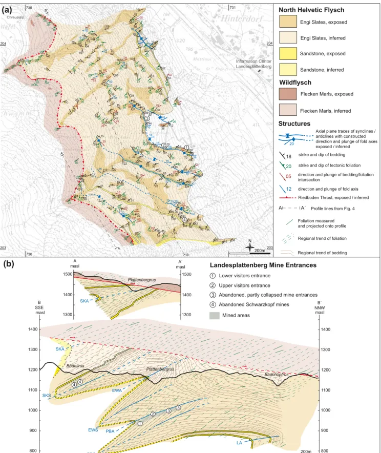
We mapped the area around Landesplattenberg Engi at the scale 1: 5,000 and conducted detailed microstructural work on thin sections (Gasser 2006). the study area covers the Engi slates on the western side of the sernft Valley between schwarz-kopfrus in the south and badchopfrus in the north (Fig. 2). Our geological map and two profiles through the study area are pre-sented in Figure 3.
the Engi slates are well exposed. Outcrops exist around the entrances to the Landesplattenberg, around the schwarz-kopf mines, along the road to chreuelalp, and in the numerous gullies cutting through the study area. Despite the steep moun-tainside and dense vegetation, all the outcrops indicated on the map are accessible and were visited. the Eocene marls on top of the Engi slates are poorly exposed. Outcrops exist only at the head of the main gullies and in some isolated areas. a) Lithology
the Engi slates consist of an alternation of mm- to cm-thick silt
and clay layers. In the lower part, several turbiditic sandstone layers of 10–50 cm thickness are intercalated with the silt and clay layers. these sandstone layers are graded and show load marks at their lower boundary, providing a good top-bottom criterium. the silt layers often show straight upper and undu-lated lower boundaries, providing a good top-bottom criterium as well. bedding is the dominant structural feature in the Engi slates and can be observed in almost every outcrop.
Microscopically, the sandstones consist of quartz grains and rock fragments (limestones, dolomites). the silt layers consist of quartz (~0.1 mm grain size), calcite, white mica and clay minerals. the clay layers consist of clay minerals, calcite, quartz
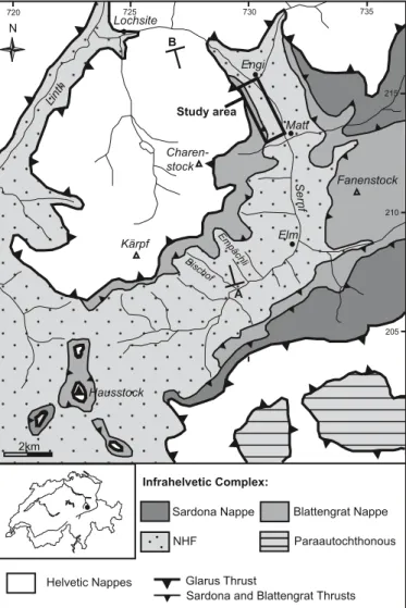
Elm Matt Engi Kärpf Hausstock Sernf Lochsite Fanenstock Charen-stock Linth Empächli Bischof Helvetic Nappes NHF Blattengrat Nappe Sardona Nappe Glarus Thrust
Sardona and Blattengrat Thrusts
Infrahelvetic Complex: Paraautochthonous Study area B A 2km N 730 720 210 725 735 205 215
Fig. 1. tectonic map of the Infrahelvetic complex in the sernft Valley (after Lihou 1996a). A-b: Profile trace of Figure 2. coordinates in swiss National Grid.
(<0.05 mm grain size), white mica and organic material. the silt layers differ from the clay layers both in the larger grain size of quartz and in the higher calcite content.
b) Foliations
two foliations were recognized: (i) a bedding-parallel slaty cleavage, and (ii) a tectonic, disjunctive, pressure solution cleavage, further referred to as Plattenberg foliation. the bed-ding-parallel slaty cleavage is defined by the alignment of
de-tritic white mica in the clay layers parallel to the bedding. It is always oriented parallel to the bedding; no folds or other tectonic features related to this foliation have been found. the tectonic Plattenberg foliation is a disjunctive cleavage (Pass-chier & trouw 2005) defined by dark seams of clay minerals and is particularly well developed in the clay layers. In the field it can only be observed with ease where it makes an angle with the bedding. It has a uniform orientation in the study area, dip-ping 15–40° towards sE (Fig. 4a). It is the only tectonic folia-tion in the study area. the bedding-parallel slaty cleavage is
Glarus Thrust Blattengrat Thrust Badchopfrus Matt Engi Blistock Charenstock Gandstock SSE NNW Study area Schwarzchopfrus 1 2 3 4 5
(a)
Riedboden Thrust Riedboden Geisstal Chüetal Geisstal Chüetal Glarus Thrust Blattengrat Thrust Badchopfrus Matt Engi Blistock Charenstock Gandstock SSE NNW Study area Schwarzchopfrus 1 2 3 4 5 1 2 3 4 5 Verrucano of Helvetic Nappes Blattengrat NappeElm Formation of NHF
Matt Sandstones (Matt Formation of NHF) Engi Slates (Matt Formation of NHF)
Landesplattenberg
(b)
6
6 Wildflysch Nappe sensu Oberholzer (1942)
Landesplattenberg
Riedboden
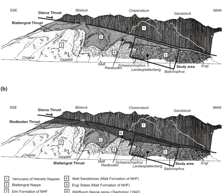
Fig. 2 (a) siegenthaler’s (1974) geological profile along the eastern side of the sernft Valley. For location of the profile see Figure 1. Note the presence of the blattengrat Nappe above the Engi slates in our study area. (b) re-interpretation in line with Oberholzer (1933, 1942) and our results.
22 27 15 16 03 16 35 36 17 11 14 16 06 03 11 38 18 30 23 12 30 13 06 12 37 15 56 02 04 11 48 08 19 14 47 06 47 25 70 65 32 20 08 07 26 58 35 32 42 40 31 35 32 37 22 22 08 30 30 45 20 40 29 65 19 36 32 42 38 35 30 26 35 15 33 45 50 25 36 35 39 30 85 30 88 07 15 12 07 02 10 40 30 70 31 65 45 35 41 02 02 28 49 40 05 18 08 19 20 75 42 25 10 85 15 15 20 10 05 15 11 45 10 30 17 4222 28 45 19 41 31 30 07 09 04 05 85 40 22 80 13 17 44 10 30 24 40 38 15 07 86 33 02 26 21 23 23 33 38 38 42 25 38 38 26 25 25 23 08 36 09 15 27 38 45 23 12 36 30 28 42 31 20 40 26 22 40 31 25 25 20 35 35 30 31 35 42 38 30 20 29 25 38 38 38 33 35 35 28 20 18 10 35 26 33 30 55 38 28 08 05 01 02 02 01 15 16 19 32 25 05 05 35 06 19 12 33 22 15 01 09 24 07 02 05 06 11 02 06 12 22 16 07 09 10 05 15 25 05 20 14 08 14 25 24 44 30 25 12 14 28 20 22 22 15 22 25 33 15 25 19 30 29 15 20 25 20 18 25 25 37 37 80 80 13 17 17 30 30 28 28 38 38 65 65 65 65 24 24 32 32 32 37 37 42 50 50 33 33 25 250707 09 09 09 12 07 07 07 12 07 38 38 Information Center Landesplattenberg Chreuelalp
Engi Slates, exposed
Sandstone, exposed
Flecken Marls, exposed
Riedboden Thrust, exposed / inferred
North Helvetic Flysch
Wildflysch
18 strike and dip of bedding
strike and dip of tectonic foliation Axial plane traces of synclines / anticlines with constructed direction and plunge of fold axes exposed / inferred
20
Engi Slates, inferred
Sandstone, inferred
Flecken Marls, inferred Structures
20
05 direction and plunge of bedding/foliation intersection
12 direction and plunge of fold axis
1 2
3 4
Landesplattenberg Mine Entrances Lower visitors entrance
Upper visitors entrance
Abandoned, partly collapsed mine entrances Abandoned Schwarzkopf mines
200m N
A A´ Profile lines from Fig. 4 1 2 3 4
(a)
(b)
B` B A` A 730 731 203 204 203 204 730 Bödelirus Plattenbergrus Badchopfrus B SSE NNWB` 200m SKA SKS EWA EWS PBA PBS LA 1 2 3 3 4 4 1500 1400 1300 1500 1400 1300 Plattenbergrus A masl maslA` SKA Mined areasRegional trend of foliation Foliation measured and projected onto profile
Regional trend of bedding
1400 1300 1200 1100 1000 900 800 1400 1300 1200 1100 1000 900 800 masl masl
Fig. 3. (a) Geological map of the study area. the upper and lower visitors entrances of Landesplattenberg that are often visited on geological excursions are marked 1 and 2, respectively. coordinates in swiss National Grid. Map base: „Katasterplan der Gemeinde Engi“, scale 1 : 10,000. (b) tectonic profiles through the study area. Profile lines are indicated on Figure 3a. sKA: schwarzkopf Anticline; sKs: schwarzkopf syncline; EWA: Erlenwald Anticline; EWs: Erlenwald syncline; PbA: Plattenberg Anticline; Pbs: Plattenberg syncline; LA: Lochrus Anticline.
responsible for good fissility of the Engi slates. Where both foliations are parallel, the quality of the slates is good enough for mining.
c) Folds
Despite the uniform lithology of the Engi slates we could de-termine the large-scale structure of the area with the help of the
turbiditic sandstone layers. the Engi slates appear to be tightly
folded at deca- to hectometer scale into NW-vergent folds with straight limbs and sharp hinges. Four large-scale anticlines and three large-scale synclines could be mapped (Fig. 3b). We refer to these folds as Plattenberg F1 folds. they are close to tight
symmetrical folds, most of them of type 1c, i.e. the limbs are thinner than the hinges (classification of ramsay 1967). the normal and inverted limbs are equally thick. An example of such a type 1c fold is exposed just right of the upper visitors entrance of Landesplattenberg mine (Fig. 5a). Other examples can be found along the partly collapsed mine entrances above the upper visitors entrance (Fig. 5b) and in the badchopfrus gully (Fig. 5c).
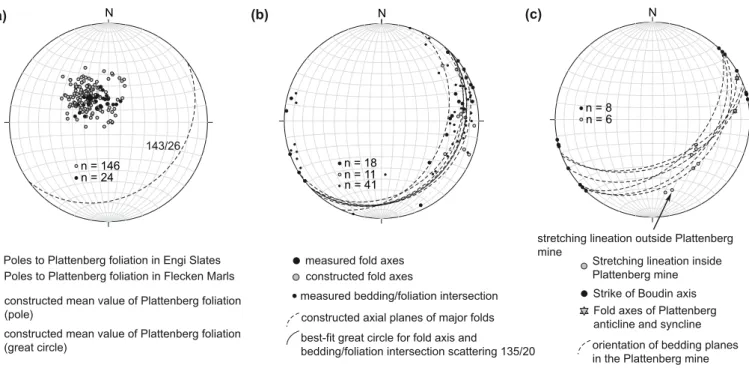
the fold axes of the F1 folds were constructed by plotting
bedding in a stereonet, whereas the fold axes of smaller F1 folds
could be measured directly in the field. the fold axes appeared to vary significantly in orientation, but they all plot on one single great circle that corresponds to the axial plane of the folds (135/20, Azimuth/Dip; Fig. 4b). the fact that the fold axes scatter on a great circle, but that the orientation of the axial
planes is constant, was also observed by siegenthaler (1974) and schmid (1975) further south in the sernft Valley. It suggests that the Engi slates were already folded when the large-scale F1 folds developed (e.g. speksnijder 1987). We refer to these
hypothetical older folds as pre-F1 folds.
the Plattenberg foliation is oriented sub-parallel to the overturned limbs of the F1 folds (at all scales) and cuts through
their axial planes. there is always a significant angle between the axial plane (i.e. the plane connecting the hinge lines of the folds) and the foliation (Fig. 5a–d). Hence, the Plattenberg fo-liation is not the axial plane fofo-liation to the F1 folds. In the case
of the F1 schwarzkopf syncline (Fig. 3, 5d), it even appeared
to cut through the overturned limb in the wrong way, i.e. the foliation is steeper than the bedding, whereas it should have been the other way round if it would have been an axial plane foliation. these observations indicate that the F1 folds are older
than the Plattenberg foliation.
Intersection lineations between bedding and Plattenberg foliation were also determined. they spread along the same great circle as the F1 fold axes (Fig. 4b). this is not a surprise,
because the Plattenberg foliation is parallel to the overturned limbs of the F1 folds.
Locally, open folds with the Plattenberg foliation as an axial plane foliation were observed. these folds most likely devel-oped simultaneously with the Plattenberg foliation. they will therefore be referred to as Plattenberg F2 folds. A good
exam-ple of an F2 fold is exposed just above the lower visitors entry
of Landesplattenberg mine (Fig. 5e).
N (b) N
Poles to Plattenberg foliation in Engi Slates Poles to Plattenberg foliation in Flecken Marls constructed mean value of Plattenberg foliation (pole)
n = 18 n = 11
(a)
constructed fold axes measured fold axes
best-fit great circle for fold axis and
bedding/foliation intersection scattering 135/20 constructed axial planes of major folds constructed mean value of Plattenberg foliation
(great circle)
n = 146 n = 24
143/26
n = 41
measured bedding/foliation intersection (c)
orientation of bedding planes in the Plattenberg mine stretching lineation outside Plattenberg mine
Stretching lineation inside Plattenberg mine Strike of Boudin axis Fold axes of Plattenberg anticline and syncline
N
n = 8 n = 6
Fig. 4. (a) Orientation of Plattenberg foliation in the Engi slates (grey dots) and the Flecken Marls (black dots). (b) Orientation of measured and constructed fold axes (big black and grey dots respectively), bedding/foliation intersections (small black dots), as well as constructed axial planes (great circles) of Plat-tenberg F1 folds in the Engi slates. Note that fold axes scatter on a great circle (the dashed great circle) approximately corresponding to the axial plane of the folds. (c) stretching lineations measured inside and outside the Landesplattenberg mine, bedding measured inside the Landesplattenberg mine, and fold axes of Plattenberg Anticline and syncline. Lower hemisphere equal area projections.
NW SE bedding axial plane foliation (a) axial plane foliation bedding NW SE (b) NW SE (c) 1cm foliation bedding axial plane bedding foliation NW SE (d) Plattenberg F2 folds Plattenberg F1 fold, Plattenberg Anticline Plattenberg foliation
(e)
lower visitors entry of Landesplattenberg (Plattehüsli) NW SE bedding axial plane foliation
Fig. 5. (a) Photograph of upper visitors entry of the Landesplattenberg mine showing an example of a Plattenberg F1 fold (the hinge of the Plattenberg Anticline). the Plattenberg foliation is oriented parallel to the overturned limb and cuts through the axial plane of the fold. the entrance to the mine is ~5 m high. (b) Photograph of an example of a Plattenberg F1 fold between the upper visitors entrance of Landesplattenberg and the abandoned mine entrances (Fig. 3). Normal and inverted limb are almost equally thick; the foliation is parallel to the overturned limb and cuts through the axial plane of the fold. (c) Photograph of a Plattenberg F1 fold in the badchopfrus (Fig. 3). Normal and inverted limb are almost equally thick. (d) Photograph illustrating relationship between sedimentary bedding and Plattenberg foliation near the schwarzkopf mines. the bedding is overturned, the foliation cuts through the bedding with the wrong orientation for an axial plane foliation. (e) sketch and photograph of the lower visitors entrance of Landesplattenberg mine. Just above the entrance, the hinge of the F1 Plattenberg Anticline is exposed. the inverted limb is oriented parallel to the Plattenberg foliation. Above this anticline, open Plattenberg F2 folds with the foliation as axial plane foliation are exposed.
NW SE (c) 1cm foliation bedding axial plane bedding foliation NW SE (d) NW SE bedding axial plane foliation (a) axial plane foliation bedding NW SE (b)
d) Stretching lineation and boudinage
According to Wettstein (1886) the slates from the Landesplat-tenberg mine show a pronounced stretching lineation. the fish fossils found in these slates are stretched by amounts of up to 2.4 parallel to this lineation. Unfortunately the lineation is extremely difficult to recognize in the field. We were able to determine its orientation at very few localities only, notably inside the Landesplattenberg mine and at one locality outside the mine (Fig. 4c). More commonly we observed boudinaged silt layers, both in the normal as well as in the inverted limbs of the Plattenberg F1 folds. the boudin axes are oriented
par-allel to the fold axes of the F1 folds. the stretching lineations
that we were able to measure made an angle of about 70° with the boudin axes and the F1 fold axes (Fig. 4c). the data are too
sparse to judge whether boudinage and stretching took place before, or after the development of the F1 folds.
e) Upper tectonic boundary of the Engi Slates
the Engi slates are bounded upwards by a thrust, which we re-fer to as riedboden thrust (not to be confused with the Glarus thrust). this thrust corresponds to a major change in local geo-morphology. the steep and rugged slope below the thrust, with many outcrops of Engi slates, gives way to a much flatter and smoother slope above the thrust, where light-grey marls are exposed in the main gullies and along the path to chreuelalp. these marls show characteristic dark stains (believed to be due to bioturbation) and belong to the Eocene Flecken Marl For-mation (siegenthaler 1974, Lihou 1995).
the relationship between the riedboden thrust and the structures in the Engi slates is well exposed near the upper part of the Plattenbergrus gully (Fig. 3). the overturned sandstone beds, which run from the schwarzkopf mines in the south-east to the Plattenbergrus gully in the north-west, are unconform-ably overlain by the Flecken Marl Formation just below Oberer Plattenbergplatz. the thrust contact itself is not exposed. the same sandstones reappear higher up in the Plattenbergrus gully in normal position, representing the normal limb of the schwarzkopf Anticline. they are also unconformably overlain by the Flecken Marl Formation. so it appears that the hinge of the schwarzkopf Anticline, which is exposed north of schwarz-chöpf, is unconformably cut-off by the riedboden thrust just north of the Plattenbergrus gully.
the thrust zone is well exposed in the upper Plattenberg-rus gully, but the thPlattenberg-rust contact itself could not be identified. between the uppermost clearly identifiable Engi slates (char-acteristic alternation of silt-and clay layers) and the lowermost clearly identifiable Flecken Marls (characteristic dark stains, i.e. bioturbation) there is a 4 to 5 m wide zone of marls that we were unable to attribute to either Engi slates or Flecken Marls. A thrust as tectonic feature (e.g. shear zone) was not observed. the only structural feature recognized was the south-east dipping Plattenberg foliation cutting through the contact zone. No other (older or younger) foliations were observed.
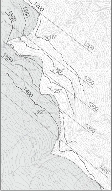
the riedboden thrust may be folded at meter-scale by open Plattenberg F2 folds, but we were unable to verify this, since the
outcrop is only a few meters wide. At large scale the thrust is a straight surface, dipping 16–25° towards NE, at least in the area we mapped (Fig. 6).
the fact that the Plattenberg F1 folds are unconformably
cut-off by the riedboden thrust, whereas the Plattenberg folia-tion cuts through the rietboden thrust, corroborates our ear-lier mentioned argument that the Plattenberg F1 folds must be
older than the Plattenberg foliation.
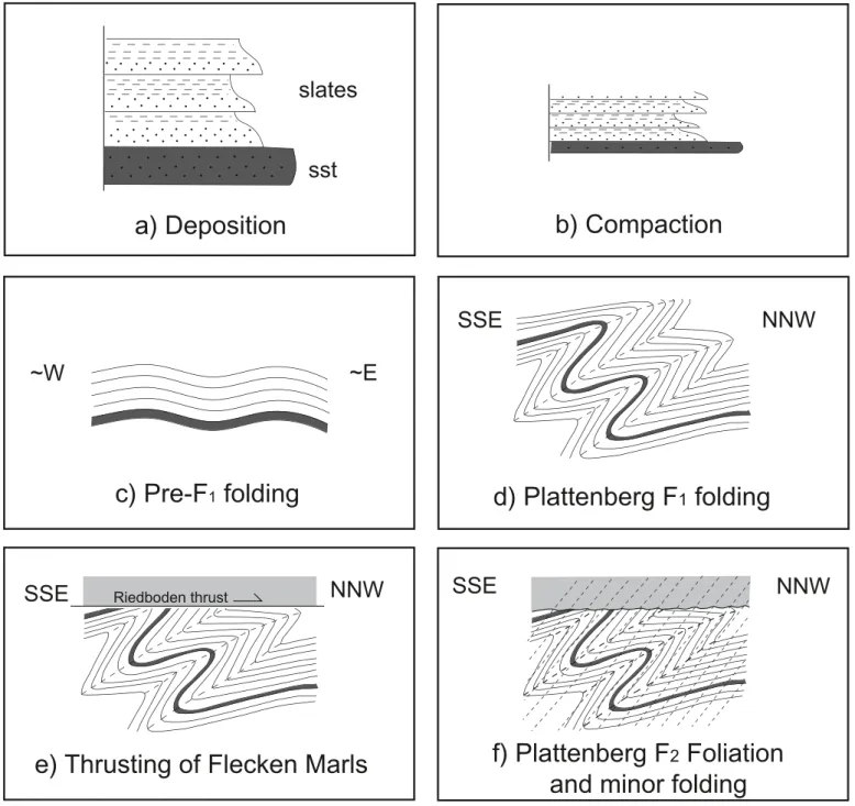
4. Model for the tectonic evolution of the Engi Slates
Our model for the tectonic evolution of the Engi slates is il-lustrated in Figure 7. After deposition and compaction of the
1400
1350
1300
1250
1200
1400
1350
1300
1250
1200
22°
25°
25°
16°
1400
1350
1300
1250
1200
1400
1350
1300
1250
1200
22°
25°
25°
25°
16°
Fig. 6. Detail of geological map with contour lines of the riedboden thrust suggesting that the thrust corresponds to a straight, 16–25° NE-dipping plane.
Engi slates (Figs. 7a–b), an early, pre-Plattenberg F1 folding
phase must have taken place, as was inferred from the scatter of Plattenberg F1 fold axes along the F1 axial planes (Fig. 7c).
then the Engi slates were folded on a regional scale during the Plattenberg F1 phase, but no axial plane cleavage
devel-oped (Fig. 7d). the F1 folds were subsequently unconformably
cut-off by the riedboden thrust, along which Eocene Flecken Marls were placed on top of the lower Oligocene Engi slates (Fig. 7e). thereafter, the Plattenberg foliation developed, both in the Engi slates and the Flecken Marls as an axial plane folia-tion to open Plattenberg F2 folds (Fig. 7f).
~W
~E
SSE
NNW
SSE
NNW
SSE
NNW
sst
slates
Riedboden thrusta) Deposition
b) Compaction
c) Pre-F
1folding
e) Thrusting of Flecken Marls
f) Plattenberg F2 Foliation
and minor folding
d) Plattenberg F1 folding
Fig. 7. Model for the tectonic evolution of the Engi slates. (a) Deposition of shales and turbiditic sandstones in the Lower Oligocene. (b) compaction and de-velopment of bedding-parallel cleavage. (c) Open Pre-Plattenberg F1 folding, as inferred from spread of F1 fold-axes, while axial planes of the F1 have a uniform orientation distribution (cf. Fig. 4b). (d) Plattenberg F1 folding, resulting in deca- to hectometer-scale tight folds with sharp hinges. (e) thrusting of Flecken Marls onto the Engi slates, which were already folded during F1. the thrust cuts unconformably through the F1 folds in the Engi slates. the Flecken Marls are assumed to belong to the Wildflysch Nappe, such as on Oberholzer’s (1942) geological map. (f) Development of sE-dipping Plattenberg foliation plus open F2 folding.
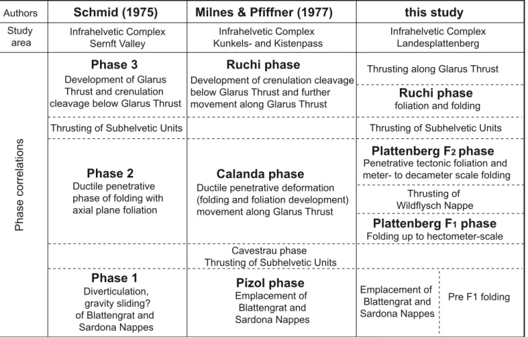
5. Comparison with previous work a) Phase correlations
Our Plattenberg F1 folds correspond to phase 2 folds of schmid
(1975) and to calanda phase folds of Milnes & Pfiffner (1977). Our Plattenberg foliation corresponds to phase 2 foliation of schmid (1975) and to calanda phase foliation of Milnes & Pfiff-ner (1977). the relationships are depicted in Figure 8. In the following, we will refer to schmid’s (1975) phase 2 as calanda phase as well. According to schmid (1975) and Milnes & Pfiff-ner (1977) the calanda phase foliation is the axial plane folia-tion to the calanda phase folds and developed simultaneously with the folds. According to us these folds and foliation devel-oped during two separate phases: the foliation cuts through the axial plane of the folds and therefore developed after the fold-ing. Moreover, the folds are cut-off by the riedboden thrust, whereas the foliation cuts through the riedboden trust. b) Fold geometries and their relationship to the foliation schmid (1975) and Pfiffner (1977, 1978, 1980) report geom-etries from folds they observed in the Infrahelvetic complex.
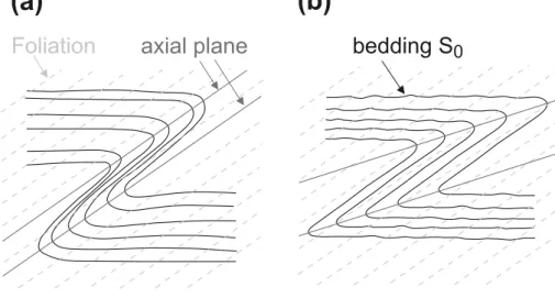
schmid (1975) describes calanda phase folds that developed in the NHF Unit in the sernft Valley, including examples from the Engi slates near the Landesplattenberg. He describes them as tight folds with the calanda phase foliation oriented sub-paral-lel to the inverted limbs. similarly, Pfiffner (1977, 1978, 1980), who studied the fold geometry of calanda phase folds in the Infrahelvetic complex in the area around Kistenpass (~15 km sW of our study area) and Kunkelspass (NW of chur), likewise describes tight folds with calanda phase foliation oriented
par-allel to the overturned limb. both authors report that the folia-tion is not only sub-parallel to the inverted limb, but also paral-lel to the fold axial plane. this requires extreme thinning of the inverted limb compared to the normal limb, such as schemati-cally depicted by Milnes (1981, in Furrer & Leu 1998; Fig. 9a) as a representative example of such folds in the Engi slates at the Landesplattenberg.
Our observations are different. First, we observed that the Plattenberg foliation is indeed oriented parallel to the overturned limbs, but not parallel to the axial planes of the F1 folds. It cuts through them with a significant angle. second,
we observed that the inverted limbs are generally not much thinner than the normal limbs (Fig. 5). the fold geometry such
Phase 3
Ruchi phase
Schmid (1975)
Milnes & Pfiffner (1977)
Phase 1
Pizol phase
Cavestrau phase Thrusting of Subhelvetic Units
Phase 2
Calanda phase
Infrahelvetic Complex Sernft Valley
Infrahelvetic Complex Kunkels- and Kistenpass
Infrahelvetic Complex Landesplattenberg Authors Study area
Phase correlations
this study
Pre F1 foldingPlattenberg F
1phase
Thrusting of Wildflysch NappePlattenberg F
2phase
Diverticulation, gravity sliding? of Blattengrat and Sardona Nappes Ductile penetrative phase of folding with axial plane foliation Development of Glarus Thrust and crenulation cleavage below Glarus ThrustEmplacement of Blattengrat and Sardona Nappes Ductile penetrative deformation (folding and foliation development) movement along Glarus Thrust Development of crenulation cleavage below Glarus Thrust and further movement along Glarus Thrust
Penetrative tectonic foliation and meter- to decameter scale folding
Folding up to hectometer-scale
Emplacement of Blattengrat and Sardona Nappes
Thrusting along Glarus Thrust
Ruchi phase
foliation and folding Thrusting of Subhelvetic Units Thrusting of Subhelvetic Units
Fig. 8. table showing the relationships between the deformational phases defined in the Infrahelvetic complex by schmid (1975), Milnes & Pfiffner (1977) and the present study.
as we observed in the Engi slates of the Landesplattenberg area is schematically depicted in Figure 9b. In fact, the ca-landa phase fold and foliation drawn by Pfiffner (1978, fig. 2b) is almost identical to the folds observed by us, also showing foliation oriented parallel to the inverted limb, with both the inverted and the normal limb being almost equally thick. We cannot imagine how this geometry can be interpreted else than by a first phase of folding (F1) without development of
an axial plane foliation, followed by a second phase of further coaxial folding (F2) with foliation development parallel to
the overturned limb of the F1 folds. the Y-axis of incremental
strain during F2 must have been approximately parallel to the
Y-axis of finite strain of the F1 folds, whereas the XY-plane
of incremental strain during F2 must have been ~20° steeper
than the XY-plane of finite strain of the F1 folds and
approxi-mately parallel to the overturned limbs of the F1 folds. the
limbs may have rotated further towards parallelism with the foliation during F2 .
Note that schmid’s (1975) phase 3 folds and crenulation foliation, corresponding to Milnes & Pfiffner’s (1977) ruchi phase folds and crenulation foliation, did not develop in our study area. As mentioned by these authors, ruchi phase struc-tures exclusively developed in a zone just below the Glarus thrust. ruchi phase crenulation foliation is well exposed in the upper chüetal, directly south of our study area, where it crenu-lates the calanda phase foliation (Plattenberg foliation in our terminology).
c) Truncated folds and the Riedboden Thrust
the Flecken Marls above the Engi slates are commonly attrib-uted to the blattengrat Nappe. the riedboden thrust is conse-quently assumed to correspond to the thrust at the base of the blattengrat Nappe, further referred to as blattengrat thrust (bisig 1957, siegenthaler 1974, schmid 1975, Lihou 1995; Fig. 2a). We prefer another interpretation.
thrusting of the blattengrat Nappe onto the NHF Unit took place during phase 1 of schmid (1975), corresponding to the Pizol phase of Milnes & Pfiffner (1977). the blattengrat Nappe was subsequently folded together with the underly-ing NHF Unit (includunderly-ing the Engi slates) durunderly-ing the calanda phase (schmid 1975, Milnes & Pfiffner 1977). A good example of a large-scale calanda phase fold folding the blattengrat thrust is exposed near the village of Matt, a few kilometers south of our study area (Fig. 2a). the calanda phase foliation cuts through the folded blattengrat thrust (see e.g. schmid 1975, fig. 2).
the riedboden thrust, however, is not folded by the ca-landa phase folds (Plattenberg F1 folds in our terminology).
the thrust cuts straightly through the calanda folds. In siegen-thaler’s (1974) profile through our study area (Fig. 2a) the blat-tengrat thrust, corresponding to our riedboden thrust, is also drawn straight. It only shows one single remarkable tight fold just north of badchopfrus. this outcrop pattern at badchopfrus may indeed suggest the existence of this fold, but we could not discover a corresponding fold in the underlying Engi slates. According to us, the outcrop pattern is better explained by intersection between the rugged topography and a straight, 16–25° NE-dipping thrust plane (see Fig. 6).
so it appears that the blattengrat trust is folded by calanda phase folds, whereas the riedboden thrust cuts through these folds. these cannot be the same thrusts. We therefore corre-late the riedboden thrust with another thrust. On the geologi-cal map of the Glarus Alps drawn by Oberholzer (1942) the Flecken Marls above the Engi slates are not attributed to the blattengrat Nappe, but to the so-called “Wildflysch” (wf on his map; Wildflysch Nappe in Oberholzer 1933; Fig. 2b). the ried-boden thrust would in this case correspond to the base of the Wildflysch Nappe, which cuts unconformably through calanda
phase folds (Plattenberg F1 folds in our terminology) just south
of our study area. For example, on Oberholzer’s (1942) map, the base of the Wildflysch Nappe unconformably cuts through
Foliation
axial plane
bedding S
0
(a)
(b)
Fig. 9. (a) Fold geometry such as observed by schmid (1975) and Pfiffner (1977, 1978). the fo-liation is oriented parallel to the axial plane and to the inverted limbs of the folds. the folds and foliation is assumed to have developed simulta-neously. (b) Geometry of folds and foliation such as observed in the present study (cf. Fig. 5). the foliation is oriented parallel to the inverted limb, but cuts through the axial plane of the folds. It developed after the folding.
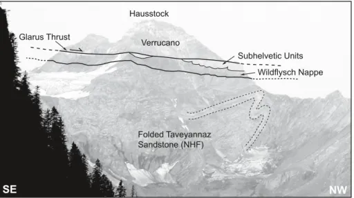
the aforementioned calanda phase syncline in the blattengrat Nappe near the village of Matt (Fig. 2b). the folded blattengrat thrust is cut-off by the base of the Wildflysch Nappe just east of riedboden Alp. Other synclines in the blattengrat Nappe west of Elm, notably at Empächli Alp and bischof Alp seem to be cut-off by the base of the Wildflysch Nappe on Oberholzer’s (1942) map as well. In the north-east face of Hausstock, an-other large-scale calanda phase fold in the taveyannaz sand-stone Formation of the NHF Unit seems to be unconformably cut-off by the base of the Wildflysch Nappe (Fig. 10).
Oberholzer (1942) drew Wildflysch (wf) almost everywhere below the Glarus thrust in the sernft Valley. Geological map-ping carried out in the whole sernft Valley by one of the au-thors (bdb, geological mapping of map sheet Elm 1: 25,000 for the swiss Geological survey, work in progress) revealed, that this Wildflysch Nappe consists of (i) a lower part that was re-named sardona Flysch by Leupold (1942) (later referred to as sardona Nappe: see e.g. Lihou 1996a, 1996b), and (ii) an upper chaotic part (schmid 1975), which is a (probably tectonic) mé-lange of rocks from the sardona Nappe, blattengrat Nappe and NHF Unit. In the western sernft Valley Oberholzer’s (1942) Wildflysch (wf) entirely seems to correspond to this mélange, which lies as a roughly 5 to 100 m thick, more or less continuous sheet or nappe below the Glarus thrust. single components of the mélange may locally be up to several hundreds of meters in size. For example, hectometer-size olistholith-like exotic bod-ies of Nummulitic limestone from the blattengrat Nappe occur in this Wildflysch mélange west of Matt and Elm in the up-per Geisstal Alp and the upup-per chüeboden Alp (Oberholzer 1942).
According to our interpretation, the Flecken Marls on top of the Engi slates are part of a large olistolith or fragment within the Wildflysch Nappe, much like the Nummulitic lime-stone fragments in the Wildflysch Nappe in the upper Geisstal Alp and the upper chüeboden Alp further south. the emplace-ment of the Wildflysch Nappe should accordingly have taken
place after Plattenberg F1 folding and before Plattenberg F2
folding and foliation development.
On the profiles through the Glarus Alps made by schmid (1975) and Lihou (1996a) the calanda phase folds in the Infra-helvetic complex are also clearly cut-off unconformably, but by the Glarus thrust itself. Our observations suggest that this unconformity should not be located at the Glarus thrust itself, but at the base of the underlying mélange of the Wildflysch Nappe.
d) Relationship between our observations and the Glarus Thrust
the Plattenberg foliation cuts through the riedboden thrust, passes upwards through the mélange of the Wildflysch Nappe, and bends northwards into parallelism with the base of the subhelvetic Units below the Glarus thrust. these units were therefore emplaced onto the mélange of the Wildflysch Nappe after the development of the Plattenberg foliation, i.e. after our Plattenberg F2 folding phase (Fig. 8). the steeply south-dipping
ruchi phase crenulation foliation, which crenulates the Plat-tenberg foliation, is the axial plane foliation of centimeter- to decameter-scale cuspate-lobate folds in the lower boundary of the subhelvetic Units. the ruchi phase therefore must have taken place after the emplacement of the subhelvetic Units onto the mélange of the Wildflysch Nappe. the ruchi phase fo-liation bends northwards into parallelism with the Lochseiten tectonite of the Glarus thrust, just ~10 cm below the thrust. the Glarus thrust consequently developed after the ruchi phase.
6. Conclusion
Our study shows that the Engi slates were folded on a deca- to hectometer scale during the Plattenberg F1 phase,
correspond-ing to phase 2 foldcorrespond-ing of schmid (1975) and to calanda phase folding of Milnes & Pfiffner (1977). these folds are unconform-Hausstock
NW
SE
Wildflysch Nappe Subhelvetic Units Folded Taveyannaz Sandstone (NHF) Glarus Thrust VerrucanoFig. 10. Photograph of north-east face of Hauss-tock in the southern sernft Valley. the dark slates below the Glarus thrust belong to Ober-holzer’s (1933, 1942) Wildflysch nappe, the base of which unconformably cuts through calanda phase folds in the underlying taveyannaz sand-stone Formation of the NHF.
ably cut-off by the riedboden thrust at the base of a (tectonic?) mélange mapped by Oberholzer (1942) as Wildflysch (wƒ). A tectonic foliation subsequently developed during the Platten-berg F2 folding phase. this Plattenberg foliation corresponds
to phase 2 foliation of schmid (1975) and calanda phase folia-tion of Milnes & Pfiffner (1977). It cuts through the riedboden thrust and developed both in the Engi slates and in the overly-ing Eocene Flecken Marls of the Wildflysch Nappe. Open Plat-tenberg F2 folds probably folded the riedboden thrust on a
meter- to decameter scale.
Our results differ from previous studies in the Infrahelvetic complex in three ways: (i) the main tectonic foliation in the area around the Landesplattenberg (Plattenberg foliation in our terminology) is not the axial plane foliation to the major folds (Plattenberg F1 folds in our terminology). In most cases
the Plattenberg foliation is oriented parallel to the overturned limb of the F1 folds and cuts through the axial plane of the F1
folds. the Plattenberg foliation is therefore younger than the F1 folds. It developed during the Plattenberg F2 phase. (ii) the
overlying riedboden thrust was not folded together with the underlying Engi slates during the Plattenberg F1 phase. the
F1 folds are cut-off unconformably by the riedboden thrust,
but the Plattenberg foliation cuts through the thrust. (ii) the Eocene Flecken Marls above the Engi slates do not belong to the blattengrat Nappe, but to the Wildflysch Nappe, such as already proposed by Oberholzer (1933, 1942).
Acknowledgements
this contribution is dedicated to Martin burkhard, who encouraged the first author to present the results of her diploma thesis to a wider audience. We thank Neil Mancktelow and Heinz Furrer for fruitful discussions and Geoff Milnes and Adrian Pfiffner for critical and very useful reviews.
rEFErENcEs
bisig, W.K. 1957: blattengratflysch und sardonaflysch im sernftal nördlich der Linie richetlipass – Elm – ramintal – Grosse scheibe. PhD thesis Nr. 2435, EtH Zürich, switzerland, 239 pp.
Fischer, H. & Villa, I. 1990: Erste K-Ar- und 40Ar/39 Ar-Hornblende-Mineral-alter des taveyannaz-sandsteins. schweizerische Mineralogische und Petrographische Mitteilungen 70, 73–75.
Furrer, H. & Leu, b. 1998: Der Landesplattenberg Engi. Forschungsgeschichte, Fossilien und Geologie. stiftung Landesplattenberg, Engi, 131 pp. Gasser, D. 2006: Vom Meeresboden auf das Hausdach – tektonische
Entwick-lung der Engi-Dachschiefer, unpublished Diploma thesis, EtH Zuerich, switzerland, 125 pp.
Leupold, W. 1942: Neue beobachtungen zur Gliederung der Flyschbildun-gen der Alpen zwischen reuss und rhein. Eclogae geologicae Helvetiae 35(2), 247–291.
Lihou, J. 1995: A new look at the blattengrat unit of eastern switzerland: Early tertiary foreland basin sediments from the south Helvetic realm. Eclogae geologicae Helvetiae 88(1), 91–114.
Lihou, J. 1996a: structure and deformational history of the Infrahelvetic flysch units, Glarus Alps, eastern switzerland. Eclogae geologicae Helvetiae 89(1), 439–460.
Lihou, J. 1996b: stratigraphy and sedimentology of the sardona unit, Glarus Alps: Upper cretaceous/middle Eocene deep-marine flysch sediments from the Ultrahelvetic realm. Eclogae geologicae Helvetiae 89(2), 721– 752.
Milnes, A.G., 1981: sonderausstellung sernftal. Katalog 2, Departement of Earth science, EtH Zurich, switzerland.
Milnes, A.G. & Pfiffner, O.A. 1977: structural development of the Infrahel-vetic complex, eastern switzerland. Eclogae geologicae Helvetiae 70(1), 83–95.
Oberholzer, J. 1933: Geologie der Glarner Alpen. beiträge zur Geologischen Karte der schweiz, schweizerische Geologische Kommission, bern, 626 pp.
Oberholzer, J. 1942: Geologische Karte des Kanton Glarus 1: 50 000. spezial-karte Nr. 117, Unveränderter Nachdruck 1984, herausgegeben von der schweizerischen Geologischen Kommission.
Passchier, c.W. & trouw, r.A.J. 2005: Microtectonics. springer, berlin, 366 pp.
Pfiffner, A.O. 1977: tektonische Untersuchungen im Infrahelvetikum der Ost-schweiz. Diss. EtH Nr. 5911, 432 pp.
Pfiffner, A.O. 1978: Der Falten- und Kleindeckenbau im Infrahelvetikum der Ostschweiz. Eclogae geologicae Helvetiae 71(1), 61–84.
Pfiffner, A.O. 1980: strain analysis in folds (Infrahelvetic complex, central Alps). tectonophysics 61 (4), 337–362.
Pfiffner, A.O. 1986: Evolution of the north Alpine foreland basin in the cen-tral Alps. In: Foreland basins, Int. Assoc. sediment. spec. Publ., Volume 9, 219–228.
ramsay, J.G. 1967: Folding and fracturing of rocks. McGraw-Hill, New York, 568 pp.
schmid, s.M. 1975: the Glarus overthrust: field evidence and mechanical model. Eclogae geologicae Helvetiae 68(2), 247–280.
siegenthaler, c. 1974: Die nordhelvetische Flysch-Gruppe im sernftal (Kt. Glarus), Unpublished PhD thesis, University of Zurich, 83 pp.
speksnijder A. 1987: the detection and significance of early deformation in the southern Variscian Pyrenees, spain: implications for regional Palaeozoic structural evolution. Geol. rundschau 76, 451–476.
trümpy, r. 1969: Die Helvetischen Decken der Ostschweiz; Versuch einer palinspastischen Korrelation und Ansätze zu einer kinematischen Analyse. Eclogae geologicae Helvetiae 62(1), 105–142.
Wettstein, A. 1886: Ueber die Fischfauna des tertiaren Glarnerschiefers: Un-tersuchung aus der geologischen sammlung in Zürich. Abhandlungen der schweizerischen Paläontologischen Gesellschaft 13(2), 103 pp.
Manuscript received October 15, 2007 revision accepted February 19, 2008 Published Online first July 25, 2008 Editorial Handling: s. schmid & s. bucher