Socio-Economic Perspectives on Shifting Cultivation
Landscapes in Northern Laos
Andreas Heinimann&Cornelia Hett&Kaspar Hurni& Peter Messerli&Michael Epprecht&Lars Jørgensen& Thomas Breu
Published online: 22 January 2013
# Springer Science+Business Media New York 2013
Abstract Despite the rapid agricultural transition that has occurred in the past decade, shifting cultivation remains a widespread agricultural practice in the northern uplands of Lao PDR. Little information is available on the basic socio-economic situation and respective possible patterns in shift-ing cultivation landscapes on a regional level. On the basis of a recent approximation of the extent of shifting cultiva-tion landscapes for two time periods and disaggregated village level census data, this paper characterizes these
landscapes in terms of key socioeconomic parameters for the whole of northern Laos. Results showed that over 550,000 people live in shifting cultivation regions. The poverty rate of this population of 46.5 % is considerably higher than the national rural rate. Most shifting cultivation landscapes are located in remote locations and a high share of the population comprises ethnic minorities, pointing to multi-dimensional marginality of these areas. We discuss whether economic growth and increased market accessibil-ity are sufficient to lift these landscapes out of poverty.
Keywords Shifting cultivation . Poverty . Accessibility . Ethnicity . Lao PDR
Introduction
For centuries, shifting cultivation has been the dominant land use system in the north of the Lao Peoples Democratic Republic (Lao PDR; hereafter referred to as Laos), securing the livelihoods of the large percentage of the rural popula-tion living in these mountainous regions. However, nowa-days, this traditional socio-ecological system is undergoing a rapid transformation. This transformation, from subsis-tence to market oriented agriculture production, has been accelerated by the increasing regional and global economic integration together with the rapidly expanding major trans-portation infrastructure (Thongmanivong et al.2009; Roder et al. 1997; Seidenberg et al. 2003; Padoch et al. 2007; World Bank2008). In addition to these economic policies and international market forces, other important driving forces are the land use policies in general and those specific to shifting cultivation; since the mid-nineties the Lao gov-ernment has aimed to reduce the area under shifting culti-vation (Lestrelin et al.2012). These policies are rooted in the policy-makers’ general perception of shifting cultivation A. Heinimann (*)
:
C. Hett:
P. Messerli:
M. Epprecht:
T. BreuCentre for Development and Environment (CDE), University of Bern, Hallerstrasse 10,
3012 Berne, Switzerland e-mail: andreas.heinimann@cde.unibe.ch C. Hett e-mail: cornelia.hett@cde.unibe.ch P. Messerli e-mail: peter.messerli@cde.unibe.ch T. Breu e-mail: thomas.breu@cde.unibe.ch K. Hurni
:
T. BreuSwiss National Centre of Competence in Research (NCCR) North-South, Institute of Geography, University of Bern, Hallerstrasse 10,
3012 Berne, Switzerland K. Hurni
e-mail: kaspar.hurni@cde.unibe.ch A. Heinimann
:
C. Hett:
M. EpprechtNCCR North-South, Ministry of Environment and Natural Resource, Prime Minister’s Office compound,
P. O. Box 1438, Vientiane, Laos L. Jørgensen
Department of Geography and Geology, University of Copenhagen, Øster Voldgade 10, 1350 Copenhagen K, Denmark
e-mail: Lj@geo.ku.dk
as a backward and underdeveloped form of land use (Mertz et al.2009), representing a poverty trap (Bounthong et al.
2003) and mainly responsible for the continuing deforesta-tion (Lawrence et al. 2010) and forest degradation (Fox
2000; Thongmanivong et al.2009). However, various local case studies suggest that frequently, upland farmers have simply not had many alternatives to shifting cultivation and that these controversial policies have had little effect (Ducourtieux2005; Roder 2001; Yokoyama2004; Saito et al.2006; Inoue et al.2007; Leek2007; Linquist et al.2007; Yamamoto et al.2009; Inoue et al.2010; Hett et al.2011; Alexander et al.2010).
Since the current and future role of shifting cultivation in the country’s agricultural development remains highly con-tested, the availability of reliable and systematic evidence on the general characteristics and dynamics of this practice beyond that of anecdotal insights of case studies is crucial. Currently, there are no national statistics on shifting cultiva-tion. It does not appear as a category in either the agricul-tural statistics or the socio-economic census. This is common throughout South East Asia (SEA) (Mertz et al.
2009). Furthermore, since official national land cover inven-tories do not only fail to capture those areas under shifting cultivation but, in fact, obscure them by classifying them as “potential forest” or “barren lands” (Hett et al.2011), there was, until recently, no established approach to the detection of such land use across larger areas beyond that of local case studies (Schmidt-Vogt et al.2009). Hence, basic data such as the areas under shifting cultivation or the population living in such regions are vague and very diverse (Mertz et al.2009; Schmidt-Vogt et al.2009).
This lack of regional level studies and consistent data has resulted in intensive debates on the management of shifting cultivation landscapes in Laos; debates that are usually highly ideological but without any factual basis. The fol-lowing characteristics of shifting cultivation are commonly assumed for the entity of the territory:
1) Shifting cultivation is mainly practiced in inaccessible uplands,
2) Shifting cultivation is mainly practiced by the ethnic minority groups of the population and
3) Shifting cultivation regions are prone to high levels of poverty.
These assumptions must be considered as being only hypothetical in nature since no consistent or recent data, either for the country as a whole or even for large areas, exist to substantiate them.
Recent studies have made initial attempts to delineate shifting cultivation landscapes and estimate the percentages of population involved. On the basis of a landscape mosaic approach using existing land cover data from 2002, the recent study of Messerli et al. (2009) was able to identify
different dominant landscapes, including those under shift-ing cultivation at the national level. Usshift-ing data from the 2005 National Population and Housing Census, the authors were also able to assess, for the first time, the population living in these landscapes. The study estimated that 17 % of the national population lived in the 29 % of the country that comprises shifting cultivation landscapes. More recently, Hurni et al. (2012, this issue) have developed an approach based on remote sensing data, which estimates the shifting cultivation dominated landscapes of northern Laos for two time periods between 2000 and 2009. These studies have laid the foundation for a further characterization of shifting cultivation landscapes using selected socio-geographic indicators.
The aim of this paper is to shed light on the basic validity of the three above-mentioned general assumptions concerning shifting cultivation landscapes throughout north-ern Laos. Specifically we use the newly available spatially explicit data on the extent of shifting cultivation areas in northern Laos as well as socio-economic data at the village level to analyze emerging (spatial) patterns in shifting cul-tivation dominated landscapes with regard to poverty, eth-nicity, accessibility as well as altitudinal belts. We hope on the one hand, to create an empirical basis for more in-depth future analyses by experts from different disciplines and on the other hand, to contribute with evidence of the general developments and policy debates on shifting cultivation in Laos.
Materials and Methods
Study Area
A considerable part of northern Laos is mountainous with limited accessibility by a few all-season roads connecting only the main district capitals. The traditional land use systems are shifting cultivation (mainly upland rice) on the slopes and paddy rice cultivation in the few available valley bottoms. Over the past decade, increased regional economic integration and policies promoting economic growth and investment have resulted in a swift transformation from subsistence to cash crop oriented agriculture and the intro-duction of tree plantations (Alton et al.2005; Ducourtieux et al.2006; Padoch et al.2007; Cramb et al.2009; Fox et al.
2009; Thongmanivong et al.2009).
The study region of the paper at hand is approximately 158,000 km2 or two-thirds of the whole of Laos and includes a large percentage of the shifting cultivation land-scapes initially estimated by Messerli et al. (2009). It was necessary to limit our study to this northern part of Laos as the recent assessment of Hurni et al. (2012, this issue), which serves as one of our sources of baseline data, was
also limited to this region. For simplicity we hereafter refer to this study area as“northern Laos”.
The Extent and Dynamics of Shifting Cultivation Landscapes
Hurni et al. (2012, this issue) recently developed a new approach using hyper-temporal MODIS satellite data in conjunction with multi-temporal Landsat imagery from 2000 to 2009 to detect shifting cultivation landscapes. This approach is based on the dominance of the very specific spatio-temporal land cover pattern of clearings and regrowth left on the landscape by shifting cultivation. In their re-search, Hurni et al. (2012, this issue) estimated the extent of shifting cultivation dominated landscapes (hereafter called shifting cultivation landscapes) for northern Laos for two time periods: 2000–2006 and 2003–2009. This overlap in time was necessary as 6 years of data were needed to delineate these landscapes. The assessment does not differentiate the land use systems or land cover outside of the delineated shifting cultivation landscapes. For the study region these are mainly forests, permanent agricultural landscapes and some built-up and water areas. This has to be considered when interpreting any comparison of socio-economic characteristics of shifting cultivation landscapes with those of non-shifting cultivation areas, as presented in the study at hand.
Data on the Socio-Economic Setting
The 2005 Population and Housing Census of the Lao De-partment of Statistics is the only coherent and spatially disaggregated countrywide socio-economic baseline in Laos (Messerli et al.2008). We used village level aggregates of this census data for all of the 6,521 villages (62 % of all villages in Laos and 58 % of the Lao population) in our study area. For data on poverty, we used the village level poverty estimates of Epprecht et al. (2008), which are esti-mates of the number of people living below the national poverty line. This estimation was based on the‘small area estimation’ method and combined information derived from the 2005 Population and Housing Census with information from the Lao Expenditure and Consumption Survey (LECS) of 2003. The poverty measure used by Epprecht at al. (2008) uses a welfare indicator of the value of per capita consump-tion expenditure, including the value of subsistence food production and the imputed rental value of owner occupied housing. The poverty line used there corresponds to the per capita expenditure, including the value of home production, required to purchase 2,100 Kcal per person per day using the food basket of households in the third quintile, plus a non-food allowance equal to what households in the third quintile spend on non-food items. In this sense, poor people
are not at an adequate subsistence level, as their per capita consumption expenditure is not enough to cover basic needs such as minimal health care, education or food. This has to be kept in mind when interpreting the results of this study as there are a number of other poverty measurement approaches that take into account an even wider concept of well-being. For Laos, however, the expenditure based poverty measure of Epprecht et al. (2008) provides the only available national data at village level and was therefore used in this study.
Furthermore, the use of socio-economic data for only one time period, aggregated at the village level, has two impor-tant consequences for the interpretation of results: 1) All the changes in socio-economic characteristics of shifting culti-vation landscapes presented were based on a change in the land use pattern over time and not on the socio-economic data. 2) It was not possible to reach any conclusion on the characteristics of sub-village populations. Therefore, al-though this study provided, for example, information on the total number of people living within shifting cultivated landscapes, not all villagers within this number may depend exclusively on shifting cultivation.
Data on Accessibility
The 2005 Population Census does not provide any informa-tion (beyond simple indicators of road access) on village remoteness. Accessibility, here understood as travel time to land itself and to basic services such as markets, has been shown to be a key determinant of land use and land use changes (Angelsen and Kaimowitz 1999; Castella et al.
2005; Chomitz and Gray 1996; Geist and Lambin 2002; Verburg et al.2004; Epprecht et al.2010).
This is especially relevant in Laos, as the still very weak transportation infrastructure in general is currently being upgraded through massive investments in this sector; firstly, through mega projects such as the establishment of economic development corridors in the Greater Mekong Sub-region (GMS) by the Asian Development Bank (ABD), or more recently, through the discussion of a Chinese funded high-speed railroad though Laos, and secondly, through a slightly slower process of upgrading smaller roads to provide rural areas with access to these economic development corridors. As a result, rural accessibility is being enhanced quite swiftly in Laos.
In order to provide insights into possible basic patterns of accessibility related to shifting cultivation landscapes, a model of physical accessibility has been developed. This model estimates travel time from any point in the study area to, for example, the nearest district capital using standard GIS raster based (in our case, 100 m resolution) cost-distance functions (see Fig.1). District capitals were chosen as the“sources” (or destinations) for this model, as they frequently act as a
development gateway or entry point to the more remote hin-terlands (Messerli et al.2008). Thus this accessibility model may also be partly understood as yielding an approximation of market accessibility. When interpreting the accessibility relat-ed result of this study, the following has to be kept in mind: firstly, physical accessibility does not automatically imply
actual access to services. In this study we only consider physical accessibility and not socio-economic distance as defined e.g. by Epprecht et al. (2010). Secondly, our accessi-bility model estimates travel time to certain destinations, taking into account the availability and quality of road net-works, terrain, land cover and potential means of transport— Fig. 1 District accessibility: Travel time from and to district capitals
thereby assuming access to typically available means of transport.
Overview of Approach
The different datasets employed in this study vary in terms of their basic geometries or spatial units of refer-ence. While the village level census data use an estimat-ed village area (i.e. the so-callestimat-ed village polygon) as a reference, the assessment of Hurni et al. (2012, this issue) used the delineated borders of shifting cultivation landscapes, and the accessibility data are raster based. To have a spatial unit of analysis at hand for this study, we used standard spatial intersections of the village polygons with the data on the extent of shifting cultivation for the two time periods as new basic geometries for all further analyses. For the assignment of the socio-economic attributes based on the village geometries to the new polygons created through the spatial overlay we followed an area-based approach: the absolute data of the socio-economic variables (e.g. population, ethnicity) were at-tributed to the new geometries on the basis of the re-spective share of area of the village polygon that was dominated by shifting cultivation in one of the two time periods considered. This mitigates to a certain extent the issue of using only village level aggregated data (see above) but naturally cannot solve it.
In order to depict socio-economic characteristics of shift-ing cultivation landscapes spatially at one point in time and provide insights into the larger overall patterns of poverty and accessibility, a landscape typology was developed. This typology was based on different combinations of the fol-lowing three main factors:
1) Presence of shifting cultivation landscapes in the sec-ond time period considered (2003–2009; based on Hurni et al.2012, this issue).
2) The travel time to district capitals based on the accessi-bility model. This was classified as two spatial categories, i.e. regions from which a district capital is reachable within a day trip (<2 h) and regions from which a district capital is more than a day trip away (>2 h). Hence a“day trip” is defined as a four-hour travel time (there and back), which we consider as a reasonable estimate in order to reach markets and services such as agricultural extension services.
3) The poverty data used were reclassified in two classes: areas where village-level poverty rates were lower than the national rural poverty rate (hereafter referred to as “better off”) and those where rates were higher (hereaf-ter referred to as “poorer”). The latest countrywide estimate of the national rural poverty rate of 40 % was used (Epprecht et al.2008).
Results
The following results section begins with an overview of the population and poverty figures in shifting cultivation land-scapes, followed by the pattern of the distribution of shifting cultivation landscapes across travel times to district capitals, the ranges of elevation and the composition of ethno-linguistic families, and ends with the presentation of a typology of shifting cultivation landscapes in relation to accessibility and poverty.
Estimation of Numbers and Poverty Rates of the Population Living in Shifting Cultivation Landscapes
Using the recent delineation of shifting cultivation land-scapes of Hurni et al. (2012, this issue), the latest available census information (Messerli et al.2008) and poverty esti-mates (Epprecht et al. 2008) we were able to estimate the population and the respective poverty rates in shifting cul-tivation landscapes in northern Laos in two time periods (see Table1). In northern Laos, both the absolute numbers and the percentages of the population living in shifting cultiva-tion landscapes were found to be considerable. Over 550,000 people or 15.6 % of the total population lived in such landscapes in the study area (2003–2006).
In the time periods examined (2000–2006 and 2003–2009) the area of shifting cultivationed landscapes decreased by 3,500 km2 (or 10 %) while the population living in such landscapes decreased by 115,300 people (or 17.3 %).
Poverty rates in shifting cultivation landscapes were 45.6 % in 2000–2006 and 46.5 % in 2003–2009. This slight increase between the two time periods (see Table1) does not imply a change in poverty per se, but rather points to the fact that the shifting cultivation landscapes in the second time period were located in poorer regions. However, both these rates were considerably higher than the national poverty rate (37.7 %) of the total population in 2005 and that of the rural population (40 %) (Epprecht et al.2008).
Accessibility and Areas of Shifting Cultivation Landscapes
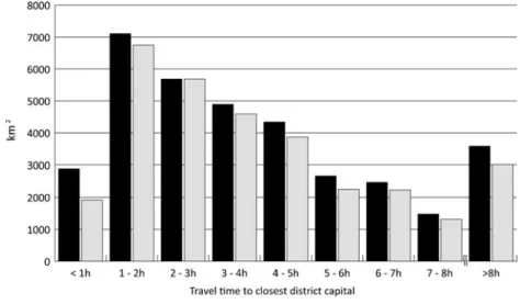
A clear pattern of the distribution of shifting cultivation landscapes across travel times to district capitals emerged (see Fig.2). Only small percentages (8 % in 2000–2006 and
6 % in 2003–2009) of the total of shifting cultivation land-scapes were found in the immediate vicinity of district capitals while percentages increased dramatically in areas slightly further away. A further decrease in accessibility correlated with a gradual decrease in areas under shifting cultivation. The increase in regions >8 h must be interpreted with care as the respective accessibility class does not fol-low the 1 h classification system and hence comprises the cumulative shifting cultivation areas beyond 8 h. Overall,
the largest shares of shifting cultivation landscapes were found in regions beyond a 2 h travel time (71.4 % and 72.6 % of the total respective area of the two time periods considered). Hence, there is a slight tendency for the shifting cultivation landscapes to be located in less accessible regions over time. In contrast, percentages of shifting culti-vation landscapes in the vicinity of towns sharply decreased between the two time periods and more than 33 % of all shifting cultivation landscapes closer than 1 h to district capitals disappeared. This decrease accounted for over 27 % of the total net decrease in shifting cultivation land-scapes between the two time periods.
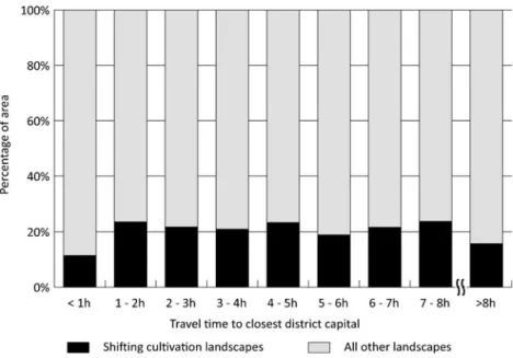
When the entire study area was considered, shifting cul-tivation landscapes proved not to be the dominant landscape at any accessibility level (see Fig. 3). However, it is still interesting to note that except for the most accessible and the most remote areas, shifting cultivation landscapes represent a very important landscape element across all other acces-sibility classes.
Furthermore, and linked to accessibility, is the question of the range of elevations at which shifting cultivation land-scapes can be found. As already mentioned, shifting culti-vation is commonly assumed to be an upland agriculture system in Laos. Our results clearly show that this is indeed
the case. Over 78 % of the shifting cultivation landscapes in 2003–2009 were above 600 masl, which can be considered upland regions in a Lao context (see Table2). The general pattern across the elevation range confirms the intuitive assumption: while only a small share of shifting cultivation is located in the lowlands (due to the dominance of e.g. permanent agriculture) the majority is located at intermedi-ate to high elevation. The share decreases in very high elevation ranges due to rough terrains and some large plains with natural grasslands (e.g. Xieng Khouang plain).
Ethno-Linguistic Families Living in Shifting Cultivation Landscapes
There are 49 different ethnic groups in Laos. These are usually classified as belonging to four ethno-linguistic fam-ilies: Lao-Tai (Tai-Kadai); Mon-Khmer (Austro-Asiatic); Hmong-Mien (Hmong-Yao, Miao-Yao); and Sino-Tibetan (mostly Tibeto-Burman) (Messerli et al. 2008). The Lao-Tai ethno-linguistic family is dominant at the national level (comprising 65 % of the total population) and also in our study area (comprising 60 %), while the other groups can, to some degree, be considered a collection of ethnic minorities (Messerli et al.2008).
Table 1 Basic socio-economic information on shifting cultiva-tion landscapes in northern Laos in 2000–2006 and 2003–2009 (area estimates are based on Hurni et al. (2012, this issue))
Shifting cultivation
landscapes 2000–2006 (t0) Shifting cultivationlandscapes 2003–2009 (t1) Net-change ofshifting cultivation landscapes t0–t1 Area km2 35,140 31,640 −3,500 Percentage of total study area 22.2 20.0 −2.2 Population 667,300 552,000 −115,300 Percentage of population of total study area
19.0 15.6 −3.3
Poverty rate 45.6 46.5 –
Fig. 2 Distribution of shifting cultivation landscapes across accessibility to district capitals
However, in shifting cultivation landscapes in northern Laos (2003–2009) the Lao-Tai made up only 19.4 % of the total population while the largest percentage was composed of other families (Mon-Khmer: 55.0 %, Sino-Tibetan: 9.8 % and Hmong-Mien: 15.8 %) (see Fig.4). This basically confirms the information found in local case studies (e.g. Thongmanivong et al. 2009; Fujita and Phanvilay 2008; Ducourtieux et al.
2006; Thongmanivong and Fujita 2006) and provided the evidence for the whole of northern Laos of shifting cultivation landscapes being mainly inhabited by ethnic minorities. For example, while only 5 % of the total Lao-Tai population of the study area lives in shifting cultivation landscapes the area is home to almost 33 % of the entire population of the other three ethno-linguistic families. This emphasizes the importance of shifting cultivation landscapes for the lives of all of the ethnic minority families in the area. The clear national pattern is that the Lao-Tai live mainly in the easily accessible areas in the floodplains (Messerli et al.2008). This pattern was also ob-servable in our results, even though we considered only those Lao-Tai living in shifting cultivation landscapes in northern Laos, where more than 70 % of the population lived closer than 2 hours’ travel from a district capital, while this was true for significantly less than 50 % of the other groups.
There was no change in this overall pattern of shifting cultivation landscapes in the two time periods considered. In shifting cultivation landscapes, the percentage of Lao-Tai of
the total population did, however, decrease slightly from 21.1 to 19.4 %. Hence there is a trend that the shares of the other three ethno-linguistic families in shifting cultiva-tion landscapes are still increasing.
Detecting Patterns: Landscape Typology of Shifting Cultivation Landscapes in 2003–2009
In order to be able to depict the basic socio-economic characteristics of shifting cultivation landscapes spatially in the first time period considered (2003–2006) and to obtain insights into the larger overall patterns of poverty and accessibility in shifting cultivation landscapes, a land-scape typology was developed and is presented here. This landscape typology classifies the shifting cultivation land-scapes by using the two main criteria of poverty and accessibility.
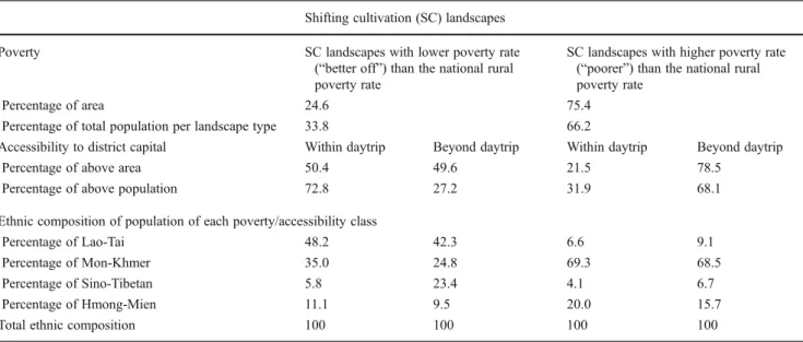
More than 75 % of the shifting cultivation landscapes are in regions that are poorer than the national rural average (see Table3). These areas are also home to more than 66 % of the population of the study region. This does not imply that all the people are poor, but rather that they live in a land-scape where the majority of people are poor, i.e. with a poverty rate higher than the national rural poverty rate. The actual calculated poverty rate in shifting cultivation landscapes (2003–2009) was 46.5 % (see Table1). Fig. 3 Shares of shifting
cultivation landscapes (2003– 2009) of the entire study area in relation to accessibility
Table 2 Percentages of shifting cultivation and all other landscapes in 2003–2009 per elevation zones Elevation zones [meter asl]
0–200 201–400 401–600 601–800 801–1000 1001–1200 1201–1400 1401–1600 >1601 Total Shifting cultivation landscapes 0.4 % 6.7 % 14.9 % 33.3 % 30.3 % 10.8 % 3.4 % 0.4 % 0.0 % 100 % Not shifting cultivation landscapes 4.7 % 11.5 % 14.8 % 19.5 % 20.6 % 18.3 % 7.9 % 2.1 % 0.5 % 100 %
A further sub-classification of the landscapes into areas beyond and within a day trip reveals clear patterns (see Table 3). In shifting cultivation landscapes where village poverty rates are lower than the national rural poverty rate, the highest percentage (72.8 %) of the population lived within a day trip of a district capital. This situation is mainly related to the higher population densities in these areas, since the per-centages of areas within (50.4 %) and beyond (49.6 %) a day trip were almost equal. In regions with poverty rates higher than the national rural poverty rate, most people (68.1 %) were found to live in those areas beyond a day trip and the respec-tive share of area was equally dominant (78.5 %).
In terms of the ethno-linguistic composition of the four landscape typologies (see Table3), it is striking that in poorer landscapes, almost 70 % of the population who lived both within (69.3 %) and beyond (68.5 %) a day trip are from the Mon-Khmer family. In contrast, the chances of“finding” mem-bers of the national ethnic majority (Lao-Tai) in such land-scapes were shown to be very small (6.6 % and 9.1 % within and beyond a day trip, respectively). Yet, in better off
landscapes the Lao-Tai make up more than 40 % of the popu-lation living within (48.2 %) and beyond (42.3 %) a day trip.
Figure5depicts the resulting spatial pattern of the typology of shifting cultivation landscapes in 2003–2009. Shifting cul-tivation landscapes that have a higher poverty rate (“poorer”) than the national rural poverty and are beyond a day trip represent the largest share (59.1 % of area and 45.1 % of population) and are mainly large connected patches. A certain clustering of better off shifting cultivation landscapes were found in the north-west (in Luang Namtha Province) and in the very north (in Phongsaly Province) of Laos.
Discussion
In the following discussion we briefly reflect on how the approach chosen in this paper compares to others in terms of the most important results. We will then discuss the com-mon beliefs and assumptions about shifting cultivation in Laos in order to present a more differentiated picture. Fig. 4 Percentages of the
population of the four ethno-linguistic families in shifting cultivation landscape (2003– 2009) and all other landscapes in the study area
Table 3 Results of the landscape typology of shifting cultivation landscapes (2003–2009) by poverty and accessibility Shifting cultivation (SC) landscapes
Poverty SC landscapes with lower poverty rate
(“better off”) than the national rural poverty rate
SC landscapes with higher poverty rate (“poorer”) than the national rural poverty rate
Percentage of area 24.6 75.4
Percentage of total population per landscape type 33.8 66.2
Accessibility to district capital Within daytrip Beyond daytrip Within daytrip Beyond daytrip
Percentage of above area 50.4 49.6 21.5 78.5
Percentage of above population 72.8 27.2 31.9 68.1
Ethnic composition of population of each poverty/accessibility class
Percentage of Lao-Tai 48.2 42.3 6.6 9.1
Percentage of Mon-Khmer 35.0 24.8 69.3 68.5
Percentage of Sino-Tibetan 5.8 23.4 4.1 6.7
Percentage of Hmong-Mien 11.1 9.5 20.0 15.7
Finally, we will explore the relevance of these insights for the current debates on development policy in the country.
It is difficult to make a direct comparison with earlier (e.g. Fujisaka1991) and more recent (Messerli et al.2009) attempts at estimating the extent and the population of shifting cultivation landscapes. These estimations were
either rather vague (Mertz et al.2009) or, as was the case in the estimations of Messerli et al. (2009), employed meth-odologies not directly comparable to ours. Nevertheless, a cautious comparison of the national figures of Messerli et al. (2009) with our figures revealed a certain similarity, al-though these figures of 29 % of the area and 17 % of the Fig. 5 Map of typology of shifting cultivation landscapes (2003–2009) and the percentage of area and population in northern Laos
population of shifting cultivation landscapes are slightly higher than ours. The different time periods of the observa-tions could well explain the small deviation and we may tentatively conclude that the main results of our study could be confirmed by two different approaches.
Our insights provide a base for reflecting on the wide-spread beliefs and generalisations that have come from local case studies on shifting cultivation in Laos. Firstly, we can confirm that shifting cultivation areas can indeed be charac-terized by considerably higher poverty rates than the nation-al average in rurnation-al areas. Secondly, shifting cultivation is generally found in remote upland areas. More specifically, the largest shares of shifting cultivation landscapes were found in regions beyond 2 hours’ travel from district capi-tals. Furthermore, shifting cultivation landscapes are mainly (78 %) found above 600 masl, corresponding to the uplands Laos. Thirdly, in such landscapes the Mon-Khmer ethno-linguistic family, an ethnic minority group at the national level, predominates. The percentages of other minority pop-ulations are also elevated in shifting cultivation landscapes when compared to national population statistics, while the overall national majority, the Lao-Tai, account for less than one fifth of the population in shifting cultivation areas.
Despite a general correspondence of our results with the already mentioned general assumptions on shifting cultivation we believe that a more differentiated picture needs to be drawn in terms of poverty, remoteness and ethnic composition. If accessibility to district capitals is considered a proxy indicator for people’s access to markets it is questionable whether shifting cultivation landscapes— given their dominance in remote areas— will benefit from a stronger market economy. This contradicts the transition, currently being promoted, from a planned to a market economy, whereby the government is attempting to incorporate even the remotest rural areas through economic growth, increased food security and greater opportunities for people’s participation (GOL2006).
More precisely, the general remoteness of shifting culti-vation landscapes confirmed through our research implies a lack of access not only to markets and capital, but also to other services such as agriculture extension and health serv-ices, and to information and technology. This greatly limits the options for future agricultural development in these remote locations (Alexander et al.2010), making shifting cultivation farmers highly dependent on forest resources for their livelihoods (Cavendish2003).
Finally, we would also like to draw attention to the results showing that ethnicity plays a key role in terms of poverty in shifting cultivation landscapes, independent of their acces-sibility. While high poverty rates can be related to high percentages of ethnic minorities, we observed recurrent patterns of shifting cultivation where lower poverty rates also coincided with high percentages of the ethnic minority populations. This may be interpreted as showing that it may
be difficult for certain ethnic minorities engaged in shifting cultivation to escape poverty even if they are living in geographically accessible areas. In other words, social dis-tances or marginality may be more important than physical distances to markets, services, infrastructure, etc. This hy-pothesis can be further strengthened by our results indicat-ing that the percentage of marginal shiftindicat-ing cultivation landscapes has increased over time.
This issue is certainly relevant in terms of the highly debated resettlement policy, a key instrument of the government of Laos for upland development and poverty alleviation. It has been a longstanding policy of the Lao government to integrate these remote populations of largely ethnic minorities into the ethnic lowland society (Evrard and Goudineau 2004; Ireson and Ireson 1991). The initial argument for such integration was that of national security. This was replaced by one focusing on a poverty alleviation strategy that involved facilitating state service delivery and market access (Lestrelin et al.
2012; Baird and Shoemaker 2007). More recently, shift-ing cultivation has been blamed for causshift-ing environmen-tal degradation (e.g. deforestation, soil erosion) and this was used as the rationale for the village resettlement policy (Lestrelin 2010; Fox 2000). Our results provide evidence that these policies, targeting the resettlement of marginal shifting cultivation villages, may have little effect, as improved accessibility may not be enough to alleviate the poverty of ethnic minorities (Alexander et al. 2010; Ducourtieux 2005). Therefore, shifting cultiva-tion landscapes persist as the dominant land use in re-mote areas of northern Laos.
Conclusion and Outlook
In this study we have presented selected socio-economic characteristics of shifting cultivation landscapes and visual-ized their respective patterns for the whole of northern Laos. We have shown that a large share of the shifting cultivation landscapes in northern Laos were indeed marginal from various perspectives, i.e. they are in remote areas, where poverty rates are higher than the national rural poverty rate and the percentages of ethnic minorities are disproportion-ately high compared to country-wide statistics. These results confirm, for the first time, for the whole of northern Laos the validity of similar insights gained from single case studies.
The results of this study on shifting cultivation land-scapes at an aggregated level for the whole of northern Laos are intended to contribute not only to the current debates on development policy but also to scientific discourses on the dynamics of shifting cultivation. At the same time, our analysis gives rise to new questions and opens the door to further in-depth studies. Additional case studies should
disentangle the complex interactions between remoteness, ethnicity and poverty in a shifting cultivation context. Fur-thermore, the understanding of changes in shifting cultiva-tion landscapes could be further improved by conducting a comparative analysis with the dynamics of other existing land use types. This would make it possible to reveal pos-sible trade-offs in terms of the different economic, social and cultural functions of land that the ongoing transforma-tion processes bring about.
Acknowledgments We acknowledge support from the Swiss Nation-al Centre of Competence in Research (NCCR) North-South, co-funded by the Swiss National Science Foundation (SNF), the Swiss Agency for Development and Cooperation (SDC) and the Centre for Develop-ment and EnvironDevelop-ment, University of Bern, Switzerland. Furthermore, this research has benefited from collaboration and support of the I-REDD+ project by the European Community’s Seventh Framework Research Programme, the Agro Biodiversity Initiative (TABI) in Laos, as well as the Global Land Project (GLP).
References
Alexander, K. S., Millar, J., and Lipscombe, N. (2010). Sustainable Development in the Uplands of Lao PDR. Sustainable Develop-ment 18(1): 62–70.
Alton, C., Blum, D., and Sananikone, S. (2005). Para Rubber Study: Hevea Brasiliensis Lao PDR. GTZ, Lao German Program Rural Development in Mountainous Areas of Northern Lao PDR. Vien-tiane, Lao PDR.
Angelsen, A., and Kaimowitz, D. (1999). Rethinking the Causes of Deforestation: Lessons from Economic Models. The World Bank Observer 14: 73–98.
Baird, I. G., and Shoemaker, B. (2007). Unsettling Experiences: Inter-nal Resettlement and InternatioInter-nal Aid Agencies in Laos Devel-opment and Change 38(5): 865–888.
Bounthong, B., Raintree, J., and Douangsavanh, L. (2003). Upland agriculture and forestry research for improving livelihoods in Lao PDR. In Saxena, K. G., Liang, L., Kono, Y., and Miyata, S. (eds.). Environment and Sustainable Development. Proceedings of an international symposium, The United Nations University, Tokyo, Japan, 29–30 October, 2003. Small-scale livelihoods and natural resources management in marginal areas: Case studies in mon-soon Asia. UNU Press, Tokyo.
Castella, J.-C., Manh, P. H., Kam, S. P., Villano, L., and Tronche, N. R. (2005). Analysis of Village Accessibility and Its Impact on Land Use Dynamics in a Mountainous Province of Northern Vietnam. Applied Geography 25(4): 308–326.
Cavendish, W. (2003). How do Forests Support, Insure and Improve the Livelihoods of the Rural Poor? A research note. CIFOR. Chomitz, K. M., and Gray, D. A. (1996). Roads, Land Use, and
Deforestation: A Spatial Model Applied to Belize. The World Bank Economic Review 10: 487–512.
Cramb, R., Colfer, C., Dressler, W., Laungaramsri, P., Le, Q., Mulyoutami, E., Peluso, N., and Wadley, R. (2009). Swidden Transformations and Rural Livelihoods in Southeast Asia. Human Ecology 37(3): 323–346.
Ducourtieux, O. (2005). Shifting cultivation and poverty eradication: A complex issue. In Bouahom, B., Glendinning, A., Nilsson, S., and Victor, M. (eds.). Poverty Reduction and Shifting Cultivation Stabi-lisation in the Uplands of Lao PDR: Technologies, Approaches and Methods for Improving Upland Livelihoods. Proceedings of a
workshop held in Luang Prabang, Lao PDR, January 27–30, 2004. National Agriculture and Forestry Reserach Institute. Vientiane, Lao PDR. Pp. 71–94.
Ducourtieux, O., Visonnavong, P., and Rossard, J. (2006). Introducing Cash Crops in Shifting Cultivation Regions— The Experience with Cardamom in Laos. Agroforestry Systems 66(1): 65–76. Epprecht, M., Minot, N., Messerli, P., and Heinimann, A. (2008).
Poverty and Inequality in the Lao PDR: Spatial Patterns and Geographic Determinants. Geographica Bernensis, Bern. Epprecht, M., Heinimann, A., Messerli, P., Schmidt-Vogt, D., and
Wiesmann, U. (2010). Accessibility as a determinant of environ-mental dynamics and socio-economic disparities in mainland South-east Asia. In: Hurni, H., and Wiesmann, U. (eds. with an international group of co-editors). Global Change and Sustainable Development: A Synthesis of Regional Experiences from Research Partnerships. Perspectives of the Swiss National Centre of Compe-tence in Research (NCCR) North-South, University of Bern, Vol. 5. Bern, Switzerland: Geographica Bernensia, pp 371–384.
Evrard, O., and Goudineau, Y. (2004). Planned Resettlement, Unex-pected Migrations and Cultural Trauma in Laos. Development and Change 35(5): 937–962.
Fox, J. M. (2000). How Blaming‘Slash and Burn’ Farmers is Defor-esting Mainland Southeast Asia. AsiaPacific Issues 47. East-West Center, Honolulu.
Fox, J., Fujita, Y., Ngidang, D., Peluso, N., Potter, L., Sakuntaladewi, N., Sturgeon, J., and Thomas, D. (2009). Policies, Political-Economy, and Swidden in Southeast Asia. Human Ecology 37 (3): 305–322.
Fujisaka, S. (1991). A Diagnostic Survey of Shifting Cultivation in Northern Laos: Targeting Research to Improve Sustainability and Productivity. Agroforestry Systems 13: 95–109.
Fujita, Y., and Phanvilay, K. (2008). Land and Forest Allocation in Lao People’s Democratic Republic: Comparison of Case Studies from Community-Based Natural Resource Management Research. So-ciety and Natural Resources 21(2): 120–133.
Geist, J. J., and Lambin, E. F. (2002). Proximate Causes and Underlying Driving Forces of Tropical Deforestation. Bioscience 52(2): 143–150. GoL (2006). Strategic Plan on Governance (2006– 2010). The Gov-ernment of the Lao PDR. November 2006. Vientiane, Lao PDR. Hett, C., Castella, J. C., Heinimann, A., and Messerli, P. (2011). A Landscape Mosaics Approach for Characterizing Swidden Sys-tems from a REDD+. Applied Geography 32: 608–618. Hurni, K., Hett, C., Heinimann, A., Messerli, P., and Wiesmann, U.
(2012). Dynamics of Shifting Cultivation Landscapes in Northern Laos Based on an Analysis of MODIS Time Series and Landsat Imagery Between 2000 and 2009. Human Ecology doi:10.1007/ s10745-012-9551-y.
Inoue, Y., Qi, J., Olioso, A., Kiyono, Y., Horie, T., Asai, H., Saito, K., Ochiai, Y., Shiraiwa, T., and Douangsavanh, L. (2007). Traceabil-ity of slash-and-burn land-use history using optical satellite sensor imagery: a basis for chronosequential assessment of ecosystem carbon stock in Laos. International Journal of Remote Sensing 28 (24): 5641–5647.
Inoue, Y., Kiyono, Y., Asai, H., Ochiai, Y., Qi, J., Olioso, A., Shiraiwa, T., Horie, T., Saito, K., and Dounagsavanh, L. (2010). Assessing Land-Use and Carbon Stock in Slash-and-Burn Ecosystems in Tropical Mountain of Laos Based on Time-Series Satellite Images. International Journal of Applied Earth Observation and Geoinformation 12(4): 287–297.
Ireson, C., and Ireson, R. (1991). Ethnicity and Development in Laos. Asian Survey 31(10): 920–937.
Lawrence, D., Radel, C., Tully, K., Schmook, B., and Schneider, L. (2010). Untangling a Decline in Tropical Forest Resil-ience: Constraints on the Sustainability of Shifting Cultiva-tion Across the Globe. Biotropica 42(1): 21–30 doi:10.1111/ j.1744-7429.2009.00599.x.
Leek, K. E. (2007). Rural Livelihood Strategies and Natural Resources in Oudomxay, Lao PDR [MSc Thesis]. University of Natural Resources and Applied Life Sciences, Vienna; Lincoln University, Christchurch, NZ, Natural Resources Management and Ecological Engineering. Lestrelin, G. (2010). Land Degradation in the Lao PDR: Discourses
and Policy. Land Use Policy 27: 424–439.
Lestrelin, G., Castella J.-C., and Bourgoin, J. (2012). Territorialising Sustainable Development: The Politics of Land-Use Planning in the Lao People’s Democratic Republic. Journal of Contemporary Asia 42(4): 581–602.
Linquist, B., Trösch, K., Pandey, S., Phouynyavong, K., and Guenat, D. (2007). Montane Paddy Rice: Development and Effects on Food Security and Livelihood Activities of Highland Lao Farm-ers. Mountain Research and Development 27(1): 40–47. Mertz, O., Leisz, S. J., Heinimann, A., Rerkasem, K., Thiha, T.,
Dressler, W., Pham, V. C., Vu, K. C., Schmidt-Vogt, D., Colfer, C. J. P., Epprecht, M., Padoch, C., and Potter, L. (2009). Who Counts? Demography of Swidden Cultivators in Southeast Asia. Human Ecology 37: 281–289 doi:10.1007/s10745-009-9249-y. Messerli, P., Heinimann, A., Epprecht, M., Phonesaly, S., Thiraka, C.,
and Minot, N. (eds.) (2008). Socio-Economic Atlas of the Lao PDR: An analysis based on the 2005 Population and Housing Census. Swiss National Center of Competence in Research (NCCR) North-South, University of Bern, Bern and Vientiane. Geographica Bernensia.
Messerli, P., Heinimann, A., and Epprecht, M. (2009). Finding Homo-geneity in HeteroHomo-geneity—A New Approach to Quantifying Landscape Mosaics Developed for the Lao PDR. Human Ecology 37: 291–304 doi:10.1007/s10745-009-9238-1.
Padoch, C., Coffey, K., Mertz, O., Leisz, S. J., Fox, J., and Wadley, R. L. (2007). The Demise of Swidden in Southeast Asia? Local Realities and Regional Ambiguities. Geografisk Tidsskrift-Danish Journal of Geography 107(1): 29–41.
Roder, W. (2001). Slash-and-Bum Rice Systems in the Hills of North-ern Lao PDR: Description, Challenges, and Opportunities. Inter-national Rice Research Institute (IRRI), Los Baños, Philippines.
Roder, W., Phengchanh, S., and Maniphone, S. (1997). Dynamics of Soil and Vegetation during Crop and Fallow Period in Slash-and-Burn Fields of Northern Laos. Geoderma 76(1-2): 131–144. Saito, K., Linquist, B., Keobualapha, B., Shiraiwa, T., and Horie, T.
(2006). Farmers’ Knowledge of Soils in Relation to Cropping Practices: A Case Study of Farmers in Upland Rice Based Slash-and-Burn Systems of Northern Laos. Geoderma 136(1-2): 64–74.
Schmidt-Vogt, D., Leisz, S. J., Mertz, O., Heinimann, A., Thiha, T., Messerli, P., Epprecht, M., Pham, V. C., Vu, K. C., Chi, K., Hardiono, M., and Dao, T. M. (2009). An Assessment of Trends in the Extent of Swidden in Southeast Asia. Human Ecology 37: 269–280 doi:10.1007/s10745-009-9239-0.
Seidenberg, C., Mertz, O., and Kias, M. B. (2003). Fallow, Labour and Livelihood in Shifting Cultivation: Implications for Deforestation in Northern Lao PDR. Geografisk Tidsskrift-Danish Journal of Geography 103(2): 71–80.
Thongmanivong, S., and Fujita, Y. (2006). Recent Land Use and Livelihood Transitions in Northern Laos. Mountain Research and Development 26(3): 237–244.
Thongmanivong, S., Fujita, Y., Phanvilay, K., and Vongvisouk, T. (2009). Agrarian Land Use Transformation in Northern Laos: From Swidden to Rubber. Southeast Asian Studies 47(3): 330– 347.
Verburg, P. H., Overmars, K. P., and Witte, N. (2004). Accessibility and Land-Use Patterns at the Forest Fringe in the North-Eastern Part of the Philippines. The Geographical Journal 170: 238–255. World Bank (2008). Policy, Market, and Agriculture Transition in the
Northern Uplands. World Bank, Washington.
Yamamoto, Y., Oberthür, T., and Lefroy, R. (2009). Spatial Identifica-tion by Satellite Imagery of the Crop–Fallow Rotation Cycle in Northern Laos. Environment, Development and Sustainability 11 (3): 639–654.
Yokoyama, S. (2004). Forest, Ethnicity and Settlement in the Moun-tainous Area of Northern Laos. Southeast Asian Studies 42(2): 132–156.