République Algérienne Démocratique et Populaire
Ministère de l’Enseignement Supérieur et de la Recherche Scientifique
No Réf :………
Centre Universitaire Abdelhafid Boussouf Mila
Institut des Sciences et Technologie Département de Mathématiques et Informatique
Mémoire préparé en vue de l’obtention du diplôme de
Master
En : Informatique
Spécialité : Sciences et Technologies de l’Information et de la Communication
(STIC)
Préparé par
:
BENNACEF Mahdi
CHERIAK Mouad
Devant le jury
Dr. Mohammed LALOU. MCB C.U.Abd Elhafid Boussouf Président Mr. Bilal DOUAS MAA C.U.Abd Elhafid Boussouf Rapporteur Mr. Mohammed BOUBAKIR MAA C.U.Abd Elhafid Boussouf Examinateur
Année Universitaire : 2016/2017
Development of a traffic information system based
on Geolocation and mobile technologies
i
iii
All praise and thanks to Allah whose blessings make possible all
good deeds, and may His prayers, be upon the Prophet Mohammed
Peace be upon Him.
Lovingly we dedicate this dissertation to our parents and
families for their unconditional support and for giving us the chance
to prove and improve ourselves through our walks in life.
We dedicate it to our friends for being so close to us and those we found
helpful whenever we needed them and have provided us with power to
finish this work
iv
We would like to convey our thanks, our gratitude and to
express our thanks to our supervisor Mr. Bilal DOUAS for his
help, guidance, and innumerable advices. We are grateful to his
encouragement and patience throughout the completion of this
work.
We also owe special thanks to my teachers and colleagues
at Mila University Center.
We would like to express our gratitude to our families,
without their patience, emotional and material support, this
work would not have been possible.
We also would like to thank Dr. Mohammed LALOU and
Mr. Mohammed BOUBAKIR for accepting to examine our
v ABSTRACT ________________________________________________________________ i
ةَذـــــبُن
___________________________________________________________________ ii Dédicace ________________________________________________________________ iii Acknowledgments ________________________________________________________ iv Table of contents __________________________________________________________ v list of figures____________________________________________________________ viii list of tables _____________________________________________________________ ix list of diagrams ___________________________________________________________ x List of Acronyms __________________________________________________________ xii Introduction ____________________________________________________________ xiii Chapter I _________________________________________________________________ 1 ROADs & information technology _____________________________________________ 1 I.1. Road network in Algeria _____________________________________________________ 1I.1.1. Classification of roads _______________________________________________________________ 2 I.1.2. East-West Highway _________________________________________________________________ 5 I.1.3. Future perspective _________________________________________________________________ 5 I.1.4. Roads quality _____________________________________________________________________ 6
I.2. Road traffic _______________________________________________________________ 7
I.2.1. Network capacity __________________________________________________________________ 8 I.2.2. Traffic management ________________________________________________________________ 9
I.3. Road safety ______________________________________________________________ 10
I.3.1. Road safety in Algeria ______________________________________________________________ 11 I.3.2. Factors threatening road safety ______________________________________________________ 11 I.3.3. improving road safety _____________________________________________________________ 13
I.4. The importance of ICT ______________________________________________________ 14
I.4.1. ICT in Algeria _____________________________________________________________________ 15 I.4.2. Apps for road traffic & safety ________________________________________________________ 16
I.5. Conclusion _______________________________________________________________ 19 Chapter II _______________________________________________________________ 20 Preliminary study _________________________________________________________ 20
vi
II.1. Project presentation _______________________________________________________ 20
II.1.1. Team ___________________________________________________________________________ 20 II.1.2. Description ______________________________________________________________________ 21
II.2. Presentation of the survey __________________________________________________ 22 II.3. Results and Analysis _______________________________________________________ 25 II.4. conclusion _______________________________________________________________ 29 Chapter III _______________________________________________________________ 31 Analysis & conceptual design _______________________________________________ 31 III.1. System architecture _______________________________________________________ 31 III.2. Actors identification _______________________________________________________ 32
III.2.1.The user ________________________________________________________________________ 32 III.2.2.The administrator _________________________________________________________________ 32
III.3. non-functional requirements ________________________________________________ 33
III.3.1.Accuracy and Precision _____________________________________________________________ 33 III.3.2.Backwards compatibility ___________________________________________________________ 33 III.3.3.SECURITY _______________________________________________________________________ 34 III.3.4.usability ________________________________________________________________________ 34 III.3.5.Response time ___________________________________________________________________ 34
III.4. Functional requirements ____________________________________________________ 34
III.4.1.Client side _______________________________________________________________________ 35 III.4.2.Server side ______________________________________________________________________ 65
III.5. Class diagram _____________________________________________________________ 78 III.6. Data dictionary ___________________________________________________________ 79 III.7. relationnel model _________________________________________________________ 80 III.8. Conclusion _______________________________________________________________ 82 Chapter IV_______________________________________________________________ 83 SYSTEM IMPLEMENTATION _________________________________________________ 83 IV.1. Tools ____________________________________________________________________ 83
IV.1.1.Android Studio (22) _______________________________________________________________ 83 IV.1.2.WampServer _____________________________________________________________________ 84 IV.1.3.StarUML (23) ____________________________________________________________________ 84
IV.2. Programming languages ____________________________________________________ 85
IV.2.1.Java (24) ________________________________________________________________________ 85 IV.2.2.The server-side language: PHP _______________________________________________________ 86 IV.2.3.Web development languages ________________________________________________________ 86 IV.2.4.Additional Resources ______________________________________________________________ 86
vii
IV.3. System Architecture _______________________________________________________ 87 IV.4. Application presentation ___________________________________________________ 88
IV.4.1.Scenario 1: Navigating the map ______________________________________________________ 88 IV.4.2.Scenario 2: Adding an event _________________________________________________________ 91 IV.4.3.Scenario 3: Sending an S.O.S ________________________________________________________ 93 IV.4.4.Admin interface __________________________________________________________________ 95
IV.5. Conclusion _______________________________________________________________ 95 Conclusion ______________________________________________________________ 96 Bibliography _____________________________________________________________ 97
viii
FIGURE 1:THE EAST-WEST HIGHWAY PROJECT ... 2
FIGURE 2: ROADS NETWORK IN MILA ... 3
FIGURE 3:DAMAGED ROADS ... 7
FIGURE 4: FRUSTRATION OF THE RESIDENTS OF ALGIERS BECAUSE OF TRAFFIC CONGESTION ... 8
FIGURE 5: REALTIME NOTIFICATIONS IN ITS... 9
FIGURE 6:TRAFFIC SIGNAL CONTROL IN ITS ... 10
FIGURE 7: RECKLESS DRIVING... 12
FIGURE 8: MISPLACED ROAD SIGNS ... 13
FIGURE 9:DEVICES MOST USED IN ALGERIA (16). ... 16
FIGURE 10:WAZE INTERFACE ... 17
FIGURE 11/USE CASES EXAMPLE OF WAZE ... 17
FIGURE 12:TARIKI INTERFACE ... 18
FIGURE 13:WINGO ... 19
FIGURE 14:ONLINE SURVEY ... 22
FIGURE 15:QUESTIONS DU FORMULAIRE ... 24
FIGURE 16: RESULTS FOR QUESTION N°1 ... 25
FIGURE 17: RESULTS FOR QUESTION N°2 ... 25
FIGURE 18: RESULTS FOR QUESTION N°3 ... 26
FIGURE 19: RESULTS FOR QUESTION N°4 ... 26
FIGURE 20: RESULTS FOR QUESTION N°5 ... 27
FIGURE 21: RESULTS FOR QUESTION N°6 ... 27
FIGURE 22:RESULTS FOR QUESTION N°7... 28
FIGURE 23:SYSTEM ARCHITECTURE ... 32
FIGURE 24:ANDROID STUDIO LOGO ... 84
FIGURE 25:WAMPSERVER LOGO... 84
FIGURE 26:STARUMLLOGO ... 85
FIGURE 27:SYSTEM ARCHITECTURE ... 88
FIGURE 28: LOGIN SCREEN... 89
FIGURE 29:WELCOME SCREEN ... 89
FIGURE 30:THE NAVIGATION MAP ... 90
FIGURE 31:THE EVENT'S DETAIL VIEW ... 90
FIGURE 32:WELCOME SCREEN FIGURE 33:ADDING AN EVENT ON THE MAP ... 91
FIGURE 34:LIST OF THE USER'S EVENTS ... 92
FIGURE 35:FILLING IN THE EVENT'S DETAILS ... 92
FIGURE 36:EMERGENCY CONTACT DIALOG ... 93
FIGURE 37:SIGN UP SCENARIO ... 94
FIGURE 38:THE WEBSITE'S INTERFACE ... 95
ix
TABLE 1:ANDROID VERSIONS DISTRIBUTION ...34
TABLE 2: LIST OF USE CASES << CLIENT >>. ...35
TABLE 3:DESCRIPTION OF USE CASE << SIGN UP >>. ...37
TABLE 4DESCRIPTION OF USE CASE << VIEW PROFILE >>. ...38
TABLE 5DESCRIPTION OF USE CASE << EDIT PROFILE >>. ...39
TABLE 6:DESCRIPTION OF USE CASE << MANAGE EMERGENCY CONTACTS >>. ...40
TABLE 7:DESCRIPTION OF USE CASE << VIEW EMERGENCY CONTACTS >>. ...41
TABLE 8:DESCRIPTION OF USE CASE << ADD EMERGENCY CONTACTS >>. ...41
TABLE 9:DESCRIPTION OF USE CASE << DELETE EMERGENCY CONTACTS >>. ...41
TABLE 10:DESCRIPTION OF USE CASE << EDIT SERVICE >>. ...44
TABLE 11:DESCRIPTION OF USE CASE << DELETE SERVICE >>. ...45
TABLE 12:DESCRIPTION OF USE CASE << RATE SERVICE >>. ...47
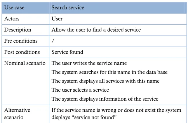
TABLE 13: DESCRIPTION OF USE CASE << SEARCH SERVICE >>. ...48
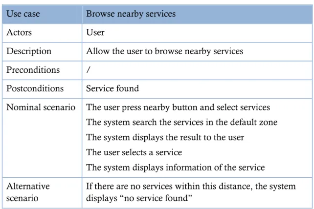
TABLE 14: DESCRIPTION OF USE CASE << BROWSE NEARBY SERVICES >>. ...50
TABLE 15:DESCRIPTION OF USE CASE << NAVIGATE >>. ...51
TABLE 16:DESCRIPTION OF USE CASE << ADD SERVICE >>. ...52
TABLE 17:DESCRIPTION OF USE CASE << ADD EVENT >>. ...53
TABLE 18:DESCRIPTION OF USE CASE << MANAGE IMAGES GALLERY >>. ...55
TABLE 19:DESCRIPTION OF USE CASE << VIEW IMAGES GALLERY >>. ...55
TABLE 20DESCRIPTION OF USE CASE << ADD IMAGES GALLERY>>. ...55
TABLE 21DESCRIPTION OF USE CASE << DELETE IMAGES GALLERY>>. ...57
TABLE 22DESCRIPTION OF USE CASE << BROWSE EVENTS >>. ...58
TABLE 23DESCRIPTION OF USE CASE << SEARCH EVENT >>. ...60
TABLE 24DESCRIPTION OF USE CASE << VIEW EVENT >>. ...61
TABLE 25DESCRIPTION OF USE CASE << RATE EVENT >>. ...62
TABLE 26DESCRIPTION OF USE CASE <<S.O.S>>. ...63
TABLE 27:LIST OF USE CASES << SERVER >>. ...65
TABLE 28DESCRIPTION OF USE CASE << MANAGE ACCOUNTS>>. ...66
TABLE 29DESCRIPTION OF USE CASE << VIEW ACCOUNTS >>. ...66
TABLE 30:DESCRIPTION OF USE CASE << VALIDATE ACCOUNT>>. ...67
TABLE 31DESCRIPTION OF USE CASE << DELETE ACCOUNT>>. ...68
TABLE 32DESCRIPTION OF USE CASE << MANAGE SERVICES >>...70
TABLE 33:DESCRIPTION OF USE CASE << VIEW SERVICES >>. ...70
TABLE 34:DESCRIPTION OF USE CASE << VALIDATE SERVICE>>. ...71
TABLE 35:DESCRIPTION OF USE CASE << DELETE SERVICE>>. ...72
TABLE 36:DESCRIPTION OF USE CASE << MANAGE EVENTS >>...73
TABLE 37:DESCRIPTION OF USE CASE << VIEW EVENTS >>. ...74
TABLE 38:DESCRIPTION OF USE CASE << VALIDATE EVENT>>. ...75
TABLE 39:DESCRIPTION OF USE CASE << DELETE EVENT>>. ...76
x
DIAGRAM 1:USE CASE DIAGRAM << CLIENT SIDE >>. ...36
DIAGRAM 2:ACTIVITY DIAGRAM << SIGN UP >>. ...37
DIAGRAM 3:SEQUENCE DIAGRAM << SIGN UP >>. ...38
DIAGRAM 4ACTIVITY DIAGRAM << VIEW PROFILE >>. ...38
DIAGRAM 5SEQUENCE DIAGRAM << VIEW PROFILE >>. ...39
DIAGRAM 6:SEQUENCE DIAGRAM << EDIT PROFILE >>. ...39
DIAGRAM 7:ACTIVITY DIAGRAM << EDIT PROFILE >>. ...40
DIAGRAM 8:SEQUENCE DIAGRAM << MANAGE EMERGENCY CONTACTS >>. ...42
DIAGRAM 9:ACTIVITY DIAGRAM << MANAGE EMERGENCY CONTACTS >>. ...42
DIAGRAM 10SEQUENCE DIAGRAM << ADD EMERGENCY CONTACTS >>. ...43
DIAGRAM 11SEQUENCE DIAGRAM << DELETE EMERGENCY CONTACTS >>. ...43
DIAGRAM 12:ACTIVITY DIAGRAM << EDIT SERVICE >>. ...44
DIAGRAM 13:SEQUENCE DIAGRAM << EDIT SERVICE >>. ...45
DIAGRAM 14:ACTIVITY DIAGRAM << DELETE SERVICE >>. ...46
DIAGRAM 15:SEQUENCE DIAGRAM << DELETE SERVICE >>. ...46
DIAGRAM 16:ACTIVITY DIAGRAM << RATE SERVICE >>. ...47
DIAGRAM 17:SEQUENCE DIAGRAM << RATE SERVICE >>. ...48
DIAGRAM 18:ACTIVITY DIAGRAM << SEARCH SERVICE >>. ...49
DIAGRAM 19:SEQUENCE DIAGRAM << SEARCH SERVICE >>. ...49
DIAGRAM 20:ACTIVITY DIAGRAM << BROWSE NEARBY SERVICES >>. ...50
DIAGRAM 21: SEQUENCE DIAGRAM << BROWSE NEARBY SERVICES >>. ...51
DIAGRAM 22:ACTIVITYDIAGRAM<<NAVIGATE>>. ...51
DIAGRAM 23:ACTIVITY DIAGRAM << ADD SERVICE >>. ...52
DIAGRAM 24:SEQUENCE DIAGRAM << ADD SERVICE >>. ...53
DIAGRAM 25:ACTIVITY DIAGRAM << ADD EVENT >>. ...54
DIAGRAM 26:SEQUENCE DIAGRAM << ADD EVENT >>. ...54
DIAGRAM 27SEQUENCE DIAGRAM << MANAGE IMAGES GALLERY >>. ...56
DIAGRAM 28SEQUENCE DIAGRAM << ADD IMAGE >>...56
DIAGRAM 29SEQUENCE DIAGRAM << DELETE IMAGE >>. ...57
DIAGRAM 30ACTIVITY DIAGRAM << MANAGE IMAGES GALLERY >>. ...58
DIAGRAM 31ACTIVITY DIAGRAM << BROWSE EVENT >>. ...59
DIAGRAM 32SEQUENCE DIAGRAM << BROWSE EVENT >>...59
DIAGRAM 33ACTIVITY DIAGRAM << SEARCH EVENT >>. ...60
DIAGRAM 34SEQUENCE DIAGRAM << SEARCH EVENT >>. ...61
DIAGRAM 35ACTIVITY DIAGRAM << VIEW EVENT >>. ...61
DIAGRAM 36ACTIVITY DIAGRAM << RATE EVENT >>. ...62
DIAGRAM 37SEQUENCE DIAGRAM << RATE EVENT >>. ...63
DIAGRAM 38ACTIVITY DIAGRAM <<S.O.S>>. ...64
DIAGRAM 39SEQUENCE DIAGRAM <<S.O.S>>. ...64
DIAGRAM 40:USE CASE DIAGRAM << SERVER >>. ...65
DIAGRAM 41: SEQUENCE DIAGRAM << MANAGE ACCOUNTS>>. ...67
xi
DIAGRAM 43SEQUENCE DIAGRAM << DELETE ACCOUNT>>. ...69
DIAGRAM 44ACTIVITY DIAGRAM << MANAGE ACCOUNT>>. ...69
DIAGRAM 45:SEQUENCE DIAGRAM << MANAGE SERVICES >>. ...70
DIAGRAM 46:SEQUENCEDIAGRAM<<VALIDATE SERVICE>>. ...71
DIAGRAM 47SEQUENCE DIAGRAM << DELETE SERVICE>>. ...72
DIAGRAM 48:ACTIVITY DIAGRAM << MANAGE SERVICES >>. ...73
DIAGRAM 49:SEQUENCE DIAGRAM << MANAGE EVENTS >>. ...74
DIAGRAM 50:SEQUENCE DIAGRAM << VALIDATE EVENT>>. ...75
DIAGRAM 51SEQUENCE DIAGRAM << DELETE EVENT>>. ...76
DIAGRAM 52:ACTIVITY DIAGRAM << MANAGE EVENTS >>. ...77
DIAGRAM 53CLASS DIAGRAM ...78
xii
2TUP 2 Tracks Unified Process
3G 3rd Generation Mobile Telecommunications
4G 4th Generation Mobile Telecommunications
ABS Anti-lock braking system
API Application Programming Interface
EEG Electroencephalography
ICT Information and Communication Technology
IDE Integrated development Environment
IT Information Technology
ITS Intelligent Transportation Systems
LTE Long Time Evolution
OBD2 On Board Diagnostic System v2
ONS National Office of Statistics
SDK Software Development Kit
SHFD Smart Headband For Drivers
UMA Arab Maghreb Union
VICS Vehicle Information and Communication System
WHO World Health Organization
xiii
We live in the era of high speed internet and advanced mobile devices. With this technology becoming so deeply rooted in our culture, and with people being out on the roads more often than they have ever been, be it on foot, in their cars or in public transport, it is essential to make the connection between those two subjects: the internet and mobile technology, and road information.
One way the internet and mobile technologies have affected roads usage is by providing real time maps navigation, which provides various services to all kinds of users, be it a user looking for a specific location or a service, or someone in an emergency trying to find the shortest path to reach their destination.
While this technological advance makes it seem like navigating the roads is a joy rather than a chore, mobile apps that provide road information services are still lacking in many areas. This lack manifests in several ways, the most important of which are the lack of coverage of rural places and even urban ones when it comes to developing and under-developed countries. Also, there are not any appropriate features that allow the users of the road to report incidents and share information about them in real time with the others.
A solution to this problem is a community-driven app, where the users are the source of information. This solution makes use of the tremendous increase of Smartphone and tablets usage, as well as the users will to share information about their surroundings in order to help others, and possibly themselves in the future. The major selling point for this type of solution is that the information shared on the map is real-time information. This provides the users with a great source for information while they are on the road.
Our intention is therefore to design and develop an application that allows the users to both share and receive instant information related to the roads they use, be it accidents, the state of the road, traffic information and even services that they can find while on the road.
xiv
In addition to this introduction, which describes the context of our work, our document includes four chapters:
The first chapter introduces the context in which this Master Thesis has been developed. It presents the road traffic and networks globally before to focus on the case of our country. In this part of the document, the main problems and solutions are exposed while the important link with technology is highlighted.
The second chapter presents a study we conducted to define our final product. We made a survey to ask future users about what their perceptions end expectations.
The third chapter is dedicated to the design of our system.
1
Chapter I
Roads are the main infrastructure for transports in Algeria. It is estimated that 85% of goods and passengers rely on roads as their primary mode of transport. Algeria has an extensive though aging road infrastructure. As well as the road infrastructure being poor, there are insufficient resources to handle the growing number of vehicles in Algeria. Furthermore, unskilled drivers and Lack of awareness are considered to be key contributing factors to the growing incidences of road traffic crashes and resulting injuries. Mobile technologies make it possible to communicate with people around you passively and indirectly and the use of these technologies has grown in a huge way. Therefore, relying on these technologies to report road condition and facilitating the car services is an excellent idea. Moreover, this would reduce the impact of the accidents and more importantly would raise public awareness on the issue.
Algeria is the largest country in Africa with an area of 2.381.741 square kilometers. It is also the tenth-largest country in the world. This wide area definitely needs a big and spread road network. Indeed, the roads reach all the
2
regions of the country but the network‟s distribution is not homogeneous. Road development essentially follows human settlement patterns and the network is much more developed in the northern coastal region where economic activities and population concentrations are heaviest.
The south is served by a limited number of national roads linking the few populated areas. Road conditions can be variable, particularly in the south on the trans-Saharan corridor, as even newly paved portions of the road often disappear under immense drifts of sand that block the route for days at a time. The east-west highway project is vastly changing the highway profile in the country. It is Algeria‟s most important road project and is now completed. The 1216 km highway, which runs between Morocco and Tunisia, connects Algeria‟s major coastal cities.
Figure 1: The east-west highway project
Future planned developments will, however, focus on the north-south highway in an attempt to realize greater connectivity for the more remotely situated populations in the south. Also these important roads need to be connected with the nearby departments to reach optimal use and take advantage of them.
Roads in Algeria are classed into three categories from an administrative perspective:
3
I.1.1.1.a. N
ATIONAL ROADSNational roads connect the different departments. The total length of national roads in Algeria reached 29573 kilometers in 2013 [1].
I.1.1.1.b. P
ROVINCIAL ROADSProvincial roads connect the municipalities and towns inside the provinces (departments). According to the ministry of public works [1], the total length of departmental roads is 24109 kilometers.
I.1.1.1.c. M
UNICIPAL WAYSMunicipal ways are established inside municipalities to connect the different cities, agglomerations and public facilities. The total length of municipal ways is 60420 kilometers.
This makes a total road system of 114282 kilometers with more than 70% of paved roads. This doesn‟t include urban ways which are estimated at around 68000 kilometers.
4
I.1.1.2.a. F
REEWAYSFreeways are roads specially designed for high speed traffic, which they not cross any other road, railway or pedestrian lane. They are accessible only at selected points [2].
Freeways are multi-Lane, divided roads with strict rules. The specifications of those rules are relative to the region they are built in but globally we may list the following:
Freeways have no cross roads so no stop light or signs are required. Also, entrance ramps have an acceleration zone to allow the cars accelerating up to the tolerable speeds before they join the freeway‟s traffic. Exits are designed under the same principle too.
Most of the maneuvers are not allowed: stopping, parking or moving back.
Defined speed interval with the highest speed limits (120km/h)
Restricted access where only complying vehicles are allowed. For example vehicles with low speed, bikes or bicycles are not allowed.
I.1.1.2.b. H
IGHWAYSA Highway (or express road) is a road or section of road that cannot cross other roads or railways and which may be prohibited to certain categories of users and vehicles. It comprises, in both directions of traffic, distinct one-way parts, each consisting of at least two lanes of traffic [2].Traffic is allowed in relatively higher speeds. Speed limit is near to freeway speed limits (100 Km/h).
I.1.1.2.c. R
OADS OR MINOR HIGHWAYSAn ordinary road a minor highway is a public highway open to vehicular traffic (2). It is a narrow road which usually has only two non separated lanes, one lane on each direction.
This class of roads comprises all the roads that don‟t comply with the rules of the two previous classes. This is the case of residential streets with stops signs, roads with numerous side streets, parking lot accesses, residential driveways, low speed limits, undivided, or shared center turn lanes [3].
5
The East-West Highway project was launched in 2009 with an estimated costing of $11.2bn. The final cost was clearly higher than that since it reached around $17bn. It is a 1216 km highway linking Annaba in the east to Tlemcen in the west, passing through 24 Algerian provinces. This is not only the biggest road project in the country but also among the biggest public works project in the world. The project was completed in 2014.
The project is a six-lane highway, three lanes in each direction. It is being developed along Algeria's borders with Morocco and Tunisia. It connects most Northern provinces including the biggest one like Algiers, Constantine, Oran… The East-West highway also has important implications for regional integration among the Arab Maghreb Union (UMA), which includes Algeria, Morocco, Tunisia, Libya and Mauritania. The project is part of the 7,000km-long Trans-Maghreb Highway, which stretches 7000 km north from Nouakchott to Rabat, and then east to Tripoli. It will connect the Maghreb states of Morocco, Algeria, Tunisia and Libya.
The final goal is to improve transport efficiency which helps increasing inter-Maghreb economic exchange, as well as tourism.
Algeria has set an ambitious infrastructure plan that aims to build a widespread network of national highways and roads by 2025. As work on Algeria‟s East-West Highway has been completed, the government has turned its attention to the next stage of its program to strengthen national transport infrastructure – the improvement of urban and provincial road networks nationwide to ease congestion and improve end-user distribution services. A series of 10 north-south connector roads will provide access to main arteries from underserved areas in the interior, through a series of interchanges and access roads.
Another strategic project is the high plateaus ring road. The technical study is achieved and 1020-km road will run roughly parallel to the East-West Highway
6
farther to the south, linking the town of El Aricha, south of Tlemcen, to Bouchebka, near the border with Tunisia [4]. The road, with two or three lanes in each direction and the possibility of expanding to three will provide a second major east-west connection. The project, which the feasibility study has demonstrated profitability, will help meeting the needs of road transport in the High Plateaus area in order to contribute to the settlement of populations residing there. [5]
Also, studies are underway on some of the links, such as the planned connector to the port city of Ténès (Chlef) and the provincial capital of Tissemsilt, 220 km to the southeast.
The aim of the project is to convert the main north - south road axes, to link between the East - West Highway and the high Plateaus By-pass, and canalize to them the traffic flow as soon as possible.
The increase in urban and peri-urban traffic intensity led that the current road network has reached its saturation limits. Facing this fact, the achievement of the second, third, and fourth bypasses, which start respectively from Zéralda to Boudouaou , from Tipaza to Bordj Menaiel and from Khemis Miliana to Bordj Bou Arreridj , has become an inevitable option.
A big part of the road network in Algeria is relatively new and has been realized under new standards. The last two decencies have seen the realization of many new roads. Also many old roads have been upgraded or maintained. The amount of unpaved roads has been noticeably reduced.
This means that the quality or the road network should be quite good. The road is reasonably good, however, it‟s subject sometimes to be blocked, due to the damages caused by floods as a result of heavy rain, especially from January to March and due to poor construction, however, the government usually act promptly to repair the damages.
7
Figure 3: Damaged roads
Even after few years from the construction, many roads get damaged due to many reasons. In many cases soil slips caused the roads to be completely closed for a long time. In some other cases the roads can operate on a single lane only with light vehicles allowed to cross because they were partially damaged. Road slip happens usually after heavy rains but natural factors aren‟t the only reasons behind such damages. The inaccuracy of the studies or realization processes is for some cases the main reason.
Another factor that affects the quality of the road network is the fact that many projects have been launched simultaneously in different sectors without the required collaboration and scheduling.
In Algeria, the number of urban passengers increased from 150m in 1970 to 530 million passengers in 2010, with an average annual increase of 2.85%, in suburban areas it increased from 80 to 650 million passengers over the same period which makes an average annual increase of 6.58% [30].
According to the same source, the tonnage of goods transported by road followed the evolution of the industry, from 32 million in 1970 to 51 million tons; the average annual trend is 1.45%. Since the first declines of the public industrial sector in 1986, the road transport of goods began a fall which intensified during the security events experienced by Algeria between 1991 and
8
1995. The recovery started in 1996, with the reforms in the sector and the establishment of private industrial units in the late 1990s.
A strong economy obviously generates big road traffic. However, most Algerian cities have chronic traffic problems. This is most perceptible in big cities where people pass long time to reach their destinations on a daily basis. When trying to find out the main reasons of this problem, we noticed three important factors.
The Algerian revenues increased considerably between 1998 and 2014. This is due to the strong Algerian oil and gas production in this period all along with their high prices in the international market during the same period. This had a clear effect on living conditions of the citizens and was revealed by the amplified purchase of vehicles. According to the report of the National Office of Statistics (ONS), the total number of vehicles almost doubled in the last 15 years. This had a negative impact on traffic flow and caused congestion in the network.
This explains why the roads are now overcrowded. It is clear that the number of cars exceeds the road network capacity. This is especially noticeable in big cities like Algiers which holds more than 25% of the national car fleet. According to last published report by the national office of statistics, by the end of 2014, the exact number of vehicles in the capital was 1.427.799 vehicles. The size of the national vehicle fleet was 5.425.558 in the same time [6].
Figure 4: frustration of the residents of Algiers because of traffic congestion
The first consequence of traffic congestion is the amplification of the road delays. Road delays are defined as the additional travel time comparing of that at free flow conditions. Congestion also pollutes the air and wastes energy. While the government started now to take measures to reduce the import of cars on one hand and expand the existing road transport infrastructure on the
9
other hand, the best solution to this issue consists actually in the improvement of the management of the network.
Road congestion is a serious problem which is adding serious challenges to modern life. Since the response to such challenges cannot be limited to traditional measures. Innovation and technology have the main role to play in finding appropriate solutions. Efficient traffic management is important to reach optimal use of the road network and helps fighting traffic congestion. The simplest technique to control and manage traffic is the use of traffic lights which are hardly ever seen in the Algerian road network. But in this information and technology era, more sophisticated solutions are feasible.
Operators may monitor and control transportation assets through a centralized platform; who will then reduce congestion, increase mobility, and improve air quality [7].
The time spent on roads needs to be reduced by adaptive control methods: that is, the management of traffic more effectively through the implementation of traffic lights, speed bumps, speed cameras and pedestrian crossings. An information management system that displays data in real time, and collects future strategy developments from any mistakes in the current travel system is also required [7].
At a higher technology level, intelligent transportation systems (ITS) are expected to provide innovative solutions relating to traffic management.
10
ITS are systems in which information and communication technologies are
applied in the field of road transport, including infrastructure, vehicles and
users, and in traffic management and mobility management, as well as for
interfaces with other modes of transport (8)
Intelligent Transportation Systems (ITS) provide two valuable services: they keep drivers informed regarding conditions on the road ahead and help to track traffic congestion levels across huge freeway networks. Given the size and scope of most Intelligent Transportation Systems, it‟s absolutely vital to allow the capability to remotely manage networked traffic monitoring and reporting devices spread throughout the system [9]. The development of ITS focus on the following applications:
Optimal use of road, traffic and travel data
Continuity of traffic
Road safety and security applications
Figure 6:Traffic signal control in ITS
Road safety is the most important and sensitive topic related to road traffic because it deals with the human life and health. Traffic problems have resulted in an increase in the number of accidents, injuries and deaths on road. Every year, road traffic related accidents kill a large number of people all over the world. According to the (WHO), about 1.25 million people die each year as a result of road traffic crashes. Between 20 and 50 million people suffer non-fatal
11
injuries, with many incurring a disability as a result of their injury. Also, road traffic crashes cost most countries 3% of their gross domestic product [10]. Without sustained action, road traffic crashes are predicted to become the seventh leading cause of death by 2030 [10].
The concept of road safety takes account of the prevention of accidents on the road in order to protect the lives of people. Road safety is the set of standards, mechanisms and measures taken by the various entities with direct or indirect relation with the road such as road users and the ones who are responsible for the construction of road infrastructures and the management of road traffic. Insecure roads thus represent all the dysfunctions generated by road traffic; it can be traffic accidents that can cause damage to property or body. The main indicators of road safety are the number of injuries, the number of fatalities, and the number of fatal accidents per kilometer.
In Algeria, the official reports reflect a very dangerous situation. In 2015, 4610 people died and about 45000 were injured. One year earlier, the recorded levels were slightly lower with 3.984 deaths and 44.546 injuries. According to the latest WHO (World Health Organization) data published in May 2014, road Traffic Accidents deaths in Algeria reached 3.55% of total deaths. The estimated death rate which is 22.3 per 100,000 of population ranks Algeria 54th in the world [10]. In both the Maghreb and Arab world, Algeria has the highest vehicular accident rate [11].
Road safety is determined by a set of factors. Dealing with these factors is the key to get to a good safety level. We can classify those risk factors into three main classes:
This class includes mainly the factors related to the state and the behavior of the drivers and the pedestrians:
Driving at high speed is a critical risk factor for road traffic incidences. The number and dimension of crashes are proportionally related to the applied
12
speed. If a crash does happen, the risk of death and serious injury is greater at higher speeds.
Driving under the influence of psychoactive substances.
Driving when exhausted, sleepy or in poor health states.
Distracted driving: mobile phones are causing the most distraction on roads.
Many drivers are causing disasters on the roads just because they are lacking the required driving skills. Sometimes it isn‟t all about skills. Driving requires also full care and attention. Many drivers haven‟t acquired the necessary consciousness for driving. This leads to improper, careless and reckless driving.
Figure 7: reckless driving
Unsafe cars amplify the risk of crashes and also their damages. Manufacturing standards are constantly improving to produce safer cars. Today, cars are equipped with many safety systems like airbags; ABS brake system or electronic stability control. They also meet the international standards and regulations.
Another decisive factor for car safety is the maintenance and the use of adequate auto parts. The use of counterfeit or bad parts can lead to unpredicted behaviors of the car system.
13
Damaged roads can cause serious traffic problems. Roads should be designed keeping in mind the safety of all road users. Also they must be regularly maintained.
Figure 8: misplaced road signs
Another significant point regarding the state of the roads are road signs. Misplaced or missing signs can cause serious problems.
There is no magic solution to stop traffic accidents but still there are ways to improve road safety:
Making roads safer by the integration of safety parameters in the design phase.
Reducing the allowed speeds. Ease of mobility must not be at the expense of safety. Also it is important to use information technology to provide new ways of calculating variable speed limits. Those values should be sensible to the context: weather, time, traffic density …
Reforming driving schools by the use of IT in both teaching and test.
Provide easy access to road and traffic information to help drivers deal with the difficulties they may encounter
Enforcing laws and ensuring their application.
Making cars safer is a critical factor to save more lives on the roads. Vehicle technology has advanced enormously, yet while cars in high-income
14
countries are increasingly safe; almost 75% of countries around the world fail to meet even the most basic international standards on vehicle safety [12]. Governments need to force the new safety standards like electronic stability control.
In our country, the motivation to reduce road harms is big. However, efforts to reduce road traffic deaths are clearly insufficient. First, we rely on traditional solutions like the multiplication of security checkpoints, the use of speed breakers or the enforcement of road safety laws. In the last decade, road safety laws have been amended three times. More rules have been added without getting significant results. It is even hard to get the law applied in many contexts.
Getting significant results regarding road safety requires involvement from multiple sectors such as education, police, health and industry. Also, the operators in the field of information and communication technologies can offer valuable help to revolutionize the traditional methods and offer new solutions adapted to our era.
With the big growth of road networks it has became hard to control and manage the traffic with traditional ways. Recently, modern equipments like radars and cameras have been added to our roads. This gave a big help but still it isn‟t sufficient to fix the problem.
The final hope to solve all traffic problems is to use the power of information and communication technologies (ICT). There are a wide variety of applications of information technology that are just beginning to be implemented that could be far more significant in our struggle to defeat traffic congestion than the building of new highways and transit routes or more government regulation [13].
In recent years, the cost of computers and mobile handsets has dropped notably. At the same time their processing power and storage capacity have increased spectacularly. The same thing is noticed with the growth of internet access and mobile communications. The lower cost and higher performance of
15
information and communication systems have had a decisive role in the spread of ICT in every field and every side of today‟s life.
In the transportation field, Intelligent Transportation Systems (ITS) like car navigation systems and VICS (Vehicle Information and Communication System), which provides drivers with traffic information, have begun to find their way into private vehicles. [14]
The position of ICT in Algeria has recorded an important delay at the continental scale as well as at the global scale. However, recently important efforts have been spent to catch up.
The introduction of mobile communications in Algeria had a tremendous impact on our economy and society. The deregulations of the telecommunication market at the beginning of the 21st century enabled a large proportion of the population to be finally connected to the global telecommunication network, and by the end of 2011; there were over 35 million mobile subscribers, compared to only 5 million in 2004 – a seven-fold increase. The launch of the 3G high-speed network during 2013 had an even more far-reaching impact, as it opened up access to the Internet for anyone with a sufficiently capable mobile phone. Also, the decision to launch the 4G LTE, taken by the government in January 2016, shows a maturity of the market [15].
Mobile devices have become very present in our daily life. On the market, there are several brands of Smartphone presenting their products with affordable prices.
In Algeria, the most popular handsets are branded Samsung and Condor. Particularly “Condor PGN518” with a market share of 4.1% and “Samsung Galaxy S3” with a 3.7% market share, according to AppBrain [16].
The most popular android versions used are Lollipop (5.1) with traffic of 25.48%, followed by KitKat with traffic of 21.3%.
16
Figure 9: Devices most used in Algeria (16).
With the relatively ease of access to the Internet and mobile devices. The segment of mobile applications devices had the minimum requirements to start and emerge. However, in this segment too we can clearly notice an important delay comparing to both regional and global advances. The number of Algerian mobile apps increased considerably the last five years but only few of them provide an added value to the local user. The lack for reliable electronic payment is one of the main reasons of this slow evolution of mobile applications development.
Road traffic information and car Accident Reporting pre-built app makes easy the knowledge of road status and simplifies the entire claims reporting process by providing an easy-to-use interface that works great on every device, there are a lot of mobile application in this field we are going to give brief demonstration of a mobile application in this area:
Waze is FREE and the world's largest community-based navigation app that join thousands of drivers in the same area who share real-time traffic & road information to save time, gas money, and improve daily commuting.
17
Figure 10: Waze interface
Waze has the features described as follows:
Live routing based on real-time traffic & road info shared by all drivers
Community reported alerts including police traps, accidents, hazards, road closures, and more
Turn-by-turn voice guided navigation
Live maps always fixed and updated by real people in your area
One tap navigation to your events from Facebook and your calendar
18
I.4.2.2.a.
T
ARIKI:
The National Gendarmerie, has developed a responsive web site dedicated to road traffic in order to help road users to be informed of the traffic situation in real time.
Figure 12:Tariki interface
As shown the figure above this web site has map that geolocate Algeria in a way that the user can point to an event and brief on its details [17].
I.4.2.2.b. W
INGOWingo covers on average more than 28,000 km of roads throughout Algeria: motorways, secondary roads (Wilaya and national roads) and main axes of cities. Updated real-time information provides good quality and accuracy.
Wingo can help you:
View real-time traffic status
19
Participate in the Wingo community by reporting all events on your route
Figure 13: Wingo
I.4.2.2.c. SMART
HEADBAND
FOR
DRIVERS
An Algerian researcher has developed a real-time alert system, consisting of an intelligent headband developed for the detection of drowsiness at the wheel, precisely and without the use of video sensors Smart Headband For Driver (SHFD) [18]. It is a real-time and mobile drowsiness detection and warning system using low-cost EEG sensors. The solution allows car drivers to receive a warning alarm and reducing the speed using OBD2 when drowsiness and low attention are detected.
The development of the road network plays an important role in the economic growth of our country. While much work still needs to be done, Algeria has already crossed important steps by strengthening the national road network and increasing connections to the main highways. However, we believe this is only a face of the global solution. Apart from working on infrastructure, information and communication technology can play a decisive role and help optimizing the use of the existing capacities.
20
Chapter II
Preliminary study is the very first step in our development process. It occurs as a result of a project start-up decision and consists of a first identification of functional and operational requirements. In this context, we conducted a survey to verify the feasibility and determine the relevance of our future application.
This document describes the work undertaken in partial fulfillment of the requirements for the degree of Master in Computer Science at Mila University Center - Algeria. The work has been achieved under the direction of Mr. Bilal DOUAS – lecturer at the same institution – by:
Mahdi BENNACEF
Mouad CHERIAK
This project constitutes an end-of-studies project which will be certified by a Master's Degree in Computer Science under the option: Information and Communication Science and Technologies (ICST).
21
The total project duration is four months. That is to say from 25/01/2017 to 25/05/2017.
Today‟s life has a high rhythm and people need to move more frequently. Using the road network has become a critical task in many regions and especially in big cities. Going to workplace can even cost you the same time you spend at there.
There are several reasons why traveling by road has become challenging, from which, is the exponential increase in the number of vehicles occupying the roads. This is causing different sorts of problems, from traffic jams to accidents. The road user needs to achieve more tasks in a short amount of time, and this is why road navigation is vital. Thus, something needs to be done to reduce the impact of road traffic.
On another hand, there is always a risk, even low, when on the road. Our project is related to these topics. We‟ll try to investigate and try to give help to the users of the road. We believe that in this era of information technology, every problem can be solved or lightened at least through the use of such technologies. This because getting information in the good place and at the good moment is very valuable.
The theme of our work is:
“Development of a traffic information system based on Geolocation
and mobile technologies”
We‟ll be interested in the state of the road and the road users. We will try to get as much information about the roads as possible in order to improve the user‟s experience. Thanks to a device that everybody knows very well: The Smartphone. What is important to us in this scope is the relationship between the road users and mobile technologies, and whether it is really capable of helping them in their daily journeys.
To determine the list of functional requirements we conducted a survey on traffic information apps and safety needs
22
To determine the functional requirements of our system, we have established an online survey of 8 quick questions related to the road network and safety and mobile technologies. We used Google Forms to create it then we published it in the Facebook page: Info Trafic Algérie, which is followed by 250000 users. The page posts about traffic information, crashes and the state of the roads.
Figure 14: Online survey
24
25
After posting this survey online we got 178 responses. We suppose that the analysis of the result will help us know the requirements for this project.
This section presents the obtained results from our survey and our analysis for each of the questions.
Figure 16: results for question n°1
The majority of users believe navigation apps are useful. A minority can‟t realize the need for this kind of apps. Exactly 4% of the users don‟t find any importance of such information. 45% of the users guess they will the app on urban roads. While 51% think it is more useful on highways (16%) or freeways (35%).
26
The majority (87%) of devices owners use Android OS, which helped us decide later what operating system we‟re going to develop for first or exclusively.
Figure 18: results for question n°3
This question intends to recognize the population interested by such services. The results show that most of the users are car or lightweight vehicles drivers (80%). Only 9% are trucks and heavy vehicles drivers. Pedestrians are also interested. To analyze this result we need first to know the distribution of car types in Algeria. According to the ONS (6) statistics cars represent 75% of the total number of vehicles. Coming back to our result, cars drivers represents 79/(9 + 79) which gives a proportion of 87%. The difference is not important and can be explained by two elements:
The first ratio doesn‟t exclude heavy vehicles that doesn‟t usually use the roads like those used in agriculture.
Cars are more likely to be driven by multiple drivers than heavy trucks so the proportion of car drivers is more important.
27
The results show that Google MAPs is the most used navigation app. Also it is important to notice that an important proportion of the users don‟t use any application. This can‟t be for other that two main possible reasons:
Google Maps and other apps don‟t fit the need of our local drivers
A part of our drivers don‟t feel at ease with such technology products or even don‟t know them.
Figure 20: results for question n°5
Most people agree on the importance of sharing information about road traffic and safety by all the users. Unfortunately, still there is no way to do that according to most of the users. A minority doesn‟t see the need for such thing. This may be because they don‟t see an importance in sharing such information or just because they have other tools to do so like using social networks.
Figure 21: results for question n°6
Crashes Closed road Traffic jam Damaged road Snow/Ice Auto services Gas Stations Other
28
In this question we tried to suggest a set of common information we collected in our surroundings to see if this fulfills the user‟s requirements or not. The question is also significant to determine the importance of every element of the set in the view of the road users.
The results show that only 3% of the users found that the suggested set doesn‟t cover their own interests. The rest expressed their interests to all the suggested elements.
While the most requested information was about congestion and traffic jams. Users would like to get all kinds of information from a navigation app, such as information about accidents, bad weather, nearby gas stations…
Figure 22:results for question n°7
Because the location of users is private information, we need to know if the users will accept to share this information in case they need urgent help. The answers show that the common opinion is that people agree to give up some of their confidential data (their geographical position in this case), in order to get help from reliable entities.
The last question asks the user to mention any features we possibly missed in our survey. This allowed us to gather valuable ideas. The main suggestions were as follow:
29
Roadwork Heavy vehicles banned Falling stones
High wind Speed breaker Radars
Fog/Smoke Rain Crimes
Car parts and accessories Car Towing Car mechanic
Vulcanizer Auto electrician Car washing service
Mosques Hotels Security checkpoints
Works offline Ease of use Parking guide
Voice guidance & recognition Nearest services Free app
Rate users privacy protection multimedia contents
Where most of the suggestions were inspiring and useful, some others couldn‟t be implemented because of objective reasons:
Prevent malicious use of the app: some suggested features are breaking local laws: this is the case for the notifications about radars or security checkpoints.
Some other features are not compatible with the design principle of the app. This is the case of offline use because the goal is to create a real time notification system which necessarily requires Internet access.
Some features needs to rely on other service providers like the parking guide.
Other features are fine but their implementation requires more time than allowed for the project. We‟ll keep them for future versions.
During the survey, we noticed a lack of culture on the use of mobile applications as an assistant in everyday life. We also noticed that a considerable part of the users don‟t use any kind of application to help them navigate the road network. Efforts are then required to market the idea especially among old drivers. On another hand, a lot of potential users already have ideas on what
30
services should be offered in navigation apps, and would like to see these features realized.
Analyzing the results of the survey, we believe that the context is motivating to launch this project. This survey allowed us to collect information about the needs and concerns of the road users. We will try to translate this through the realization of this project. Because most users (87%) use Android platform we‟ll start developing a version for android first.
31
Chapter III
In this stage of the development cycle, we’ll define the architecture of our system and its functional requirements. These requirements describe the expected behavior of the system with the different actors. We’ll present a set of diagrams to better describe the different operations. We used UML as our modeling language.
The previous step helped us to better define the properties of the solution we have to put up. Looking back to study presented in the previous chapter we can clearly make the following conclusions:
The volume of information managed by the system is huge and can‟t be handled by a mobile handset: pictures, wide area coverage…
The source of the information managed by the system is the user itself. Only the users distributed on the different locations of the road network have the ability to supply the system with satisfactory information because there are no other centralized or distributed entities that have the ability or the will to cover such a large area. We saw in the preliminary study that most of the users like to share important events they come across while on the road.
32
This means that we need two levels in our logical architecture: A server that store and provide information and the clients who access the stored information but also feed the server data stores. This is kind of Client/Server architecture with two levels:
Figure 23: System architecture
An actor is an entity which acts on the system may interact. In our context we have two obvious actors:
The first actor is the targeted user of the system. The user can get information from the system and probably have a reaction to it. Also, as we mentioned in the previous section; the users also feed the system with all its information. Some features of the system need the user to be identified to work properly. Accordingly, the set of features available to the users depend on whether the user is authenticated or not. The user acts on the client side of the system only.
The users are responsible for feeding the system with the information. This makes a centralized control of the system obligatory to avoid any malicious or illegal manipulation. This is the reason why the system needs an administrator too. The main mission of the administrator is to review critical operations and act according to that by rejecting or validating them. The user acts on the client side of the system only.
Data network
Store information request Information request
reply
Clients Server
33
These requirements include the technical requirements which don‟t cover apparent functions and features of the system. They are also called sometimes "Quality Attributes." For example, attributes such as performance, security, usability or compatibility aren't a "feature" of the system, but are a required characteristic [19].
The specification needs to describe any such attributes the user requires.
Road safety is a critical issue which needs to deal with it carefully. Publishing inaccurate information can cause serious damage to the users of the road. While reaching an accuracy and precision of the data of 100% is not always within the means, the system has to guarantee an accuracy rate greater than 95%.
Android platform upgrade rapidly and more features are added every new release.
Supporting older versions means you can reach more devices but you‟ll have access to fewer features. At the opposite, supporting a higher version let you use more feature but your application can run on fewer devices. Thus, a tradeoff needs to be found depending on the context.
In our case, the system should support all Android versions down to 4.1 (Jellybean). This allows the client application to be used on about 98% of Android devices.
The following table shows the distribution of the different versions [20]:
Version Nom API Distribution
2.3.x Gingerbread 10 01.0% 01.0%
34 4.1.x 4.2.x 4.3 Jelly Bean 16 04.0% 11.3% 17 05.7% 18 01.6% 4.4 KitKat 19 21.9% 21.9% 5.0 Lollipop 21 09.8% 32.9% 5.1 22 23.1% 6.0 Marshmallow 23 30.7% 30.7% 7.0 Nougat 24 00.9% 01.2% 7.1 25 00.3%
Table 1: Android versions distribution
The client application needs to use the geographical location which is private information. This information shouldn‟t be shared or stored without the consent of the user.
Because the targeted population is much diversified on many dimensions (age, gender…), the application interfaces needs to be easy to understand. Audio control is a valuable plus.
When an important event is added to the system, the other users should be able to view it in a relatively short time.
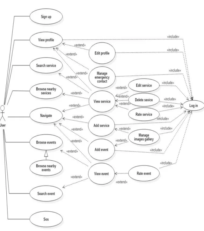
Use cases have become a widespread practice for capturing functional requirements. Use cases represent the things of value that the system performs for its actors [21]. Our functional requirements for both client and server side is captured in the following use cases:
35
N° Use case
1 Sign up
2 View profile 3 Edit profile
4 Manage emergency contacts
View emergency contacts Add emergency contact Delete emergency contact
5 View service
6 Edit service 7 Delete service 8 Rate service 9 Search service
10 Browse nearby services 11 Navigate
12 Add service 13 Add event
14 Manage images gallery
View images gallery Add image Delete image 15 Browse events 16 Search event 17 View event 18 Rate event 19 S.O.S
36
37
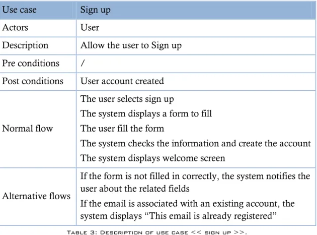
III.4.1.3.a. S
IGN UPUse case Sign up
Actors User
Description Allow the user to Sign up
Pre conditions /
Post conditions User account created
Normal flow
The user selects sign up
The system displays a form to fill The user fill the form
The system checks the information and create the account The system displays welcome screen
Alternative flows
If the form is not filled in correctly, the system notifies the user about the related fields
If the email is associated with an existing account, the system displays “This email is already registered”
Table 3: Description of use case << sign up >>.
38
Diagram 3: Sequence diagram << sign up >>.
III.4.1.3.b. V
IEW PROFILEUse case View profile
Actors User
Description Allow to edit profile or view service
Preconditions User is authenticated
Nominal Scenario
The user selects View profile The system displays profile
Table 4 Description of use case << view profile >>.
39
Diagram 5 Sequence diagram << view profile >>.
III.4.1.3.c. E
DIT PROFILEUse case Edit profile
Actors User
Description Allow to edit profile
Pre conditions User is authenticated Post conditions Profile edited
Nominal
Scenario The user views his profile and then selects edit profile The system displays a form filled with the user‟s info The user modifies the desired information and confirms The system updates the profile
The system displays “the profile has been edited” Alternative
Scenario If the form is not filled in correctly, the system notifies the user about the related fields
Table 5 Description of use case << edit profile >>.
40
Diagram 7: Activity diagram << edit profile >>.
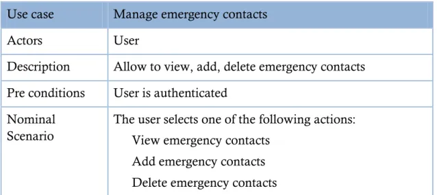
III.4.1.3.d. M
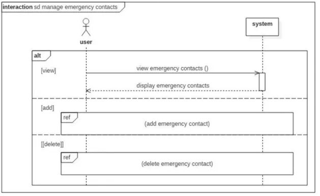
ANAGE EMERGENCY CONTACTSIn the case of Manage emergency contacts and Manage images gallery the edit process is realized by removing then adding a new item.
Use case Manage emergency contacts
Actors User
Description Allow to view, add, delete emergency contacts
Pre conditions User is authenticated Nominal
Scenario
The user selects one of the following actions: View emergency contacts
Add emergency contacts Delete emergency contacts
41
View emergency contacts
Use case View emergency contacts
Description Allow the user to view emergency contacts
Preconditions User profile is displayed Nominal
Scenario
The user selects view emergency contacts The system displays user‟s emergency contacts
Table 7: Description of use case << view emergency contacts >>.
Add emergency contact
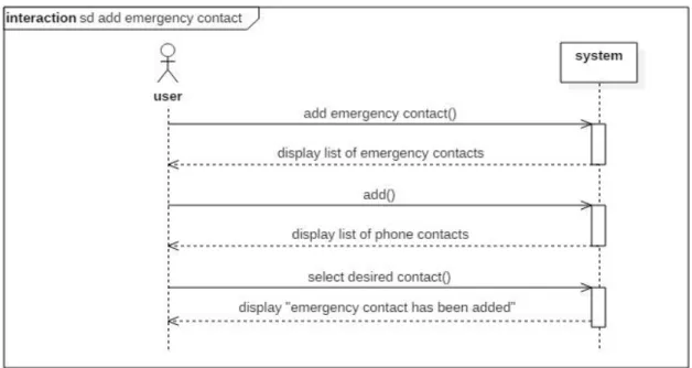
Use case Add emergency contacts
Description Allow the user to add an emergency contact
Pre conditions User profile is displayed
Post conditions emergency contact added
Nominal scenario The user selects „add emergency contact‟ The system displays phone‟s contacts.
The user select the desired contact and validate the action The system displays “emergency contact has been added”
Table 8: Description of use case << add emergency contacts >>.
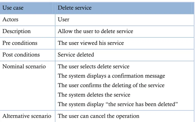
Delete emergency contact
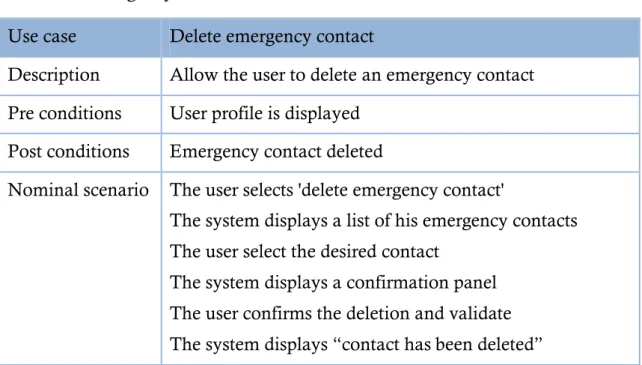
Use case Delete emergency contact
Description Allow the user to delete an emergency contact
Pre conditions User profile is displayed
Post conditions Emergency contact deleted
Nominal scenario The user selects 'delete emergency contact'
The system displays a list of his emergency contacts The user select the desired contact
The system displays a confirmation panel The user confirms the deletion and validate The system displays “contact has been deleted”
42
Diagram 8: Sequence diagram << manage emergency contacts >>.
43
Diagram 10 Sequence diagram << add emergency contacts >>.