HAL Id: hal-01110591
https://hal.archives-ouvertes.fr/hal-01110591
Submitted on 21 Aug 2020
HAL is a multi-disciplinary open access
archive for the deposit and dissemination of
sci-entific research documents, whether they are
pub-lished or not. The documents may come from
teaching and research institutions in France or
abroad, or from public or private research centers.
L’archive ouverte pluridisciplinaire HAL, est
destinée au dépôt et à la diffusion de documents
scientifiques de niveau recherche, publiés ou non,
émanant des établissements d’enseignement et de
recherche français ou étrangers, des laboratoires
publics ou privés.
Estimating the return times of great Himalayan
earthquakes in eastern Nepal: Evidence from the Patu
and Bardibas strands of the Main Frontal Thrust
Laurent Bollinger, Soma Nath Sapkota, P. Tapponnier, Yann Klinger, Magali
Rizza, Jerome van der Woerd, D. R. Tiwari, R Pandey, Adnand Bitri,
Séverine Bès de Berc
To cite this version:
Laurent Bollinger, Soma Nath Sapkota, P. Tapponnier, Yann Klinger, Magali Rizza, et al.. Estimating
the return times of great Himalayan earthquakes in eastern Nepal: Evidence from the Patu and
Bardibas strands of the Main Frontal Thrust. Journal of Geophysical Research : Solid Earth, American
Geophysical Union, 2014, 119 (9), pp.7123-7163. �10.1002/2014JB010970�. �hal-01110591�
Estimating the return times of great Himalayan
earthquakes in eastern Nepal: Evidence
from the Patu and Bardibas strands
of the Main Frontal Thrust
L. Bollinger1, S. N. Sapkota2, P. Tapponnier3, Y. Klinger4, M. Rizza3, J. Van der Woerd5, D. R. Tiwari2, R. Pandey2, A. Bitri6, and S. Bes de Berc6
1
CEA, DAM, DIF, Arpajon, Arpajon, France,2Department of Mines and Geology, National Seismological Center, Kathmandu, Nepal,3Earth Observatory of Singapore, Nanyang Technological University, Singapore, Singapore,4Institut de Physique du
Globe de Paris, Sorbonne Paris Cité, Université Paris Diderot, UMR 7154 CNRS, Paris, France,5Institut de physique du Globe de Strasbourg, UMR CNRS/UdS, Strasbourg, France,6BRGM, Orléans, France
Abstract
The return times of large Himalayan earthquakes are poorly constrained. Despite historical devastation of cities along the mountain range, definitive links between events and specific segments of the Main Frontal Thrust (MFT) are not established, and paleoseismological records have not documented the occurrence of several similar events at the same location. In east central Nepal, however, recently discovered primary surface ruptures of that megathrust in the A.D. 1255 and 1934 earthquakes are associated withflights of tectonically uplifted terraces. We present here a refined, longer slip history of the MFT’s two overlapping strands (Patu and Bardibas Thrusts) in that region, based on updated geomorphic/neotectonic mapping of active faulting, two 1.3 km long shallow seismic profiles, and logging of two river-cut cliffs, three paleoseismological trenches, and several pits, with constraints from 74 detrital charcoals and 14 cosmogenic nuclide ages. The amount of hanging wall uplift on the Patu thrust since 3650 ± 450 years requires three more events than the two aforementioned. The uplift rate (8.5 ± 1.5 mm/yr), thrust dip (25° ± 5°N), and apparent characteristic behavior imply 12–17.5 m of slip per event. On the Bardibas thrust, discrete pulses of colluvial deposition resulting from the coseismic growth of aflexural fold scarp suggest the occurrence of six or seven paleo-earthquakes in the last 4500 ± 50 years. The coeval rupture of both strands during great Himalayan earthquakes implies that in eastern Nepal, the late Holocene return times of such earthquakes probably ranged between 750 ± 140 and 870 ± 350 years.1. Introduction
Although constraining the source parameters of large earthquakes along the Himalayan arc is of paramount socioeconomic importance, it has remained a particularly challenging scientific issue. The Main Himalayan/Frontal Thrust (MHT/MFT), the largest and fastest-slipping continental megathrust, poses one of the greatest menaces to the northern Indian subcontinent, threatening tens of millions of people in the Himalayan foothills and Ganges plain. But serious obstacles have stood in the way of assessing seismic hazard in Northern India and Nepal.
First, great twentieth century earthquakes (M≥ 8), particularly the 1905 (Kangra) and 1934 (Bihar-Nepal) events (Figure 1a) have long been categorized as blind events. Therefore, opinions differ, still, on whether they ruptured the MHT [e.g., Molnar and Pandey, 1989; Bilham et al., 2001], the basement sediment interface beneath the Ganges foreland basin [e.g., Seeber and Armbruster, 1981], or a fault within the Indian plate [e.g., Kayal, 2010; Srivastava et al., 2013], among various scenarios (Figure 1b). While perpetuating an ambiguous view of source potency, such conflicting interpretations also raise the question of whether the surface ruptures of earthquakes as large as the 1905 and 1934 events might have been missed, both at the time of occurrence and later on in trenches.
Second, along most segments of the MFT, trenches excavated across visible surface scarps (Figure 1c) have generally exposed only one event in the last 1000 years at any single site [e.g., Lavé et al., 2005; Kumar et al., 2006, 2010; Malik et al., 2010]. The lack of sizeable paleoseismological time series has thus precluded a reliable determination of the average return times of great earthquakes.
Journal of Geophysical Research: Solid Earth
RESEARCH ARTICLE
10.1002/2014JB010970Key Points:
• Six great earthquakes since mid-Holocene
• Coseismic slip of 12 to 17.5 m • Return times of 700–900 years
Correspondence to: L. Bollinger,
laurent.bollinger@cea.fr
Citation:
Bollinger, L., S. N. Sapkota, P. Tapponnier, Y. Klinger, M. Rizza, J. Van der Woerd, D. R. Tiwari, R. Pandey, A. Bitri, and S. Bes de Berc (2014), Estimating the return times of great Himalayan earthquakes in eastern Nepal: Evidence from the Patu and Bardibas strands of the Main Frontal Thrust, J. Geophys. Res. Solid Earth, 119, 7123–7163, doi:10.1002/ 2014JB010970.
Received 21 JAN 2014 Accepted 3 AUG 2014
Accepted article online 7 AUG 2014 Published online 15 SEP 2014
Third, taken together, the absence of twentieth century surface ruptures andfirm recurrence time constraints have left open the possibility that earthquakes much greater (up to M ~ 9?) than hitherto recorded might occur on a multimillennial timescale [e.g., Lavé et al., 2005; Feldl and Bilham, 2006]. This inference is thought to be corroborated by the postulated rupture lengths (>800 km?) of certain medieval earthquakes [e.g., Kumar et al., 2010] and by GPS-based interseismic slip deficit balancing the shortening rate across the MFT derived from geomorphological studies (e.g., Ader et al. [2012], in Nepal). Taken at face value, both might imply infrequent events with magnitudes> 8.5 and return periods > 1000 years, which might further suggest variable slip rates and very irregular return times [Mugnier et al., 2013]. Hence, mostly because of lack of evidence or speculative interpretation of insufficient data, the maximum magnitude and return period of great Himalayan earthquakes remains a subject of hot debate [e.g., Ader et al., 2012; Kumahara and Jayangondaperumal, 2013; Mugnier et al., 2013; Srivastava et al., 2013; Schiffman et al., 2013].
In an effort to move that debate forward, we started newfieldwork in the regions of Nepal struck by the most recent large earthquakes (1833 and 1934) [Campbell, 1833a, 1833b; Bilham, 1995; Rana, 1935; Dunn et al., 1939] (Figure 1a). We targeted the area of the Himalayan front most severely shaken by these events, in the
Figure 1. (a) Map of great and large earthquakes along Main Himalayan Thrust, since 1830. Box is frame of Figure 2, including most of cross section in Figure 1b. (b) Schematic section a-a′: colored lines show fault rupture scenarios and source sizes proposed for different events, mostly of thrust type. Small red and orange circles are recently recorded instrumental earthquakes (1< ML < 5) under Kathmandu klippe [Cattin and Avouac, 2000] and in eastern Nepal [Monsalve et al., 2006] respectively, with most prominent cluster on midcrustal thrust ramp. (c) Paleoseismological sites investigated by different research groups along the Himalayan front [Kondo et al., 2008; Kumar et al., 2001, 2006, 2010; Kumahara in Sapkota, 2011; Lavé et al., 2005; Malik et al., 2010; Mugnier et al., 2011; Sapkota et al., 2013; Upreti et al., 2000; Yule et al., 2006a, 2006b].
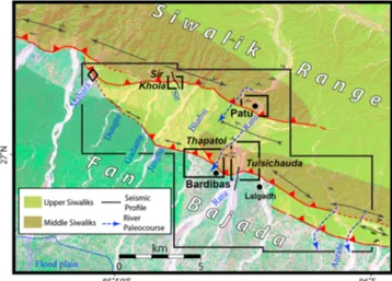
easternmost part of the country (Figure 2). An initial, rapid survey of the Quaternary geology and geomorphology of the MFT between 84.5°E and 88.5°E was performed, over a distance of ~ 400 km (Figures 1 and 2). The principal goals of this broad reconnaissance were to visit and compare active faulting sites documented by previous groups [e.g., Nakata, 1989; Upreti et al., 2000; Lavé et al., 2005], to obtain a synoptic view of the present tectonics of the Himalayan front and to search for scarps or exposures showing evidence for very young thrust movement. In the region near Bardibas (Figure 3), we found particularly clear evidence of modern surface deformation and rupture on one of two strands of the Main Frontal Thrust (MFT) where it crossed the Sir Khola river valley [Sapkota et al., 2013]. Our paleoseismological logging of a river-cut cliff and of trench walls, constrained by14C dating of several sedimentary units unambiguously suggested that the last and penultimate surface ruptures on that strand (Patu thrust) should be attributed respectively to the 1934 earthquake, and to the great A.D. 1255 event chronicled to have killed the king and one third of the Kathmandu valley population [Sapkota et al., 2013].
This paper documents in much greater detail our neotectonic and paleoseismological findings at that initial site. It places them into a more robust regional framework by adding evidence from three additional geomorphological/paleoseismological sites. Dating sedimentary records in the footwall and hanging wall of the overlapping Patu and Bardibas strands of the MFT with 74 detrital charcoal ages and 14 cosmogenic10Be and
26Al exposure ages, elucidates their seismic
history much further back than was previously feasible, into the middle Holocene. We also provide thefirst images of the near-surface geometry of both thrust strands on two 1.3 km long profiles acquired during a dedicated shallow seismic survey. Finally, we propose first-order estimates of the mean return period and average coseismic slip of great earthquakes along this stretch of the Himalayan front.
2. Methodology
Our mapping of the tectonic geomorphology and landscape evolution was based on the comparative study of more than 400 aerial photographs—acquired in the past 50 years at scales of 1/12,000 and 1/50,000—submetric
Figure 2. (a) Macroseismic isoseist map of 1934 earthquake (MMI, black contours, solid or dashed, from Dunn et al. [1939]). Thick red lines are profiles leveled in 1920 and 1935 along slump belt (stippled area), from which measured elevation changes are plottted in Figure 2b [Bomford, 1937; Bilham et al., 1998]. (b) Elevation changes derived from comparison of benchmark leveling measurements on profiles in Figure 2a [Bomford, 1937; Bilham et al., 1998]. c) Macroseismic intensities (colored dots) and isoseist map of 1934 earthquake (MSK1964, after Ambraseys and Douglas [2004], corrected for liquefaction effects). Continuous and dashed colored lines with roman numbers, and red and white stars, are macroseismic isoseismals (MSK1964), and instrumental and macroseismic epicenters, of 1934 and 1833 earth-quakes, respectively. Thin black lines are borders. Small grey box: location of Figure 3. Red teethed polyline marks minimum stretch of 1934 MFT surface rupture, from Sapkota et al. [2013]. Red arrows with question marks point to possible maximum rupture extent.
resolution Ikonos and Geoeye-1 satellite images, and photographs taken during a dedicated helicopter survey. The results were reported on recent, 1/25,000 scale, topographic base maps. In thefield, we used Total-Station leveling and Terrestrial Lidar Scanning (TLS; Riegl VZ 400), with three-dimensional precisions of 30 and 2 cm, respectively, to survey the local tectonic/fluvial geomorphology and log the structure of newly excavated or refreshed exposures.
We identified and correlated fluvial terraces according to their relative heights, absolute elevations, lithologic consolidation, and degree of incision and lateritization. They were labeled upward from the most local base level, i.e., the present-day riverflood plains, T0. Terrace abandonment generally results from climatic or/and tectonic events that lead to changes in hydrology and river base level. Where possible, we searched for horizons of similar lithology and age on either side of scarps. Such horizons, as well as most accessiblefluvial
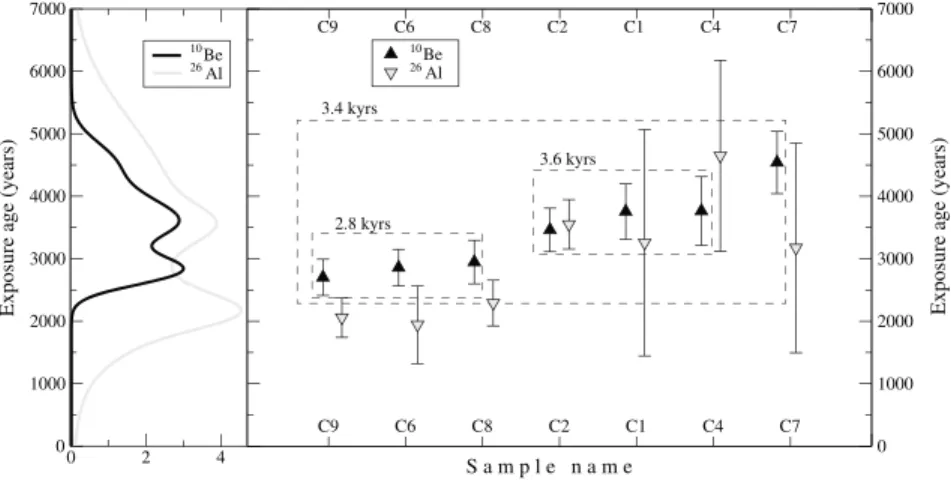
conglomerates, were systematically inspected and sampled for detrital charcoals. The sampling strategy was dedicated to dating terrace abandonment. For that purpose, we sampled both the uppermost high-energy levels—pebbles and gravel deposited in the main stream channels—and overlying overbank deposits. We dated 74 of the charcoal samples collected. The charcoal fragments were prepared and analyzed by accelerator mass spectrometry at the Scottish Universities Environmental Research Centre (SUERC) radiocarbon dating laboratory in Glasgow, at Commissariat à l’Eénergie Atomique (CEA)/Artemis in France and at Beta Analytics in the USA. The results, with associated uncertainties, are listed in Tables 1 and 3. The total time span of the stratigraphic record sampled, calibrated with IntCal09 [Reimer et al., 2009], extends roughly from 7000 B.C. to the present. In order to better constrain the date of the events, given the uncertainties associated with the dating of earthquake horizons, the chronological sequences were further refined by introducing a priori information from stratigraphic relationships, using the Bayesian analysis approach of Oxcal 4.1 [Bronk Ramsey, 2008]. This approach was also used in order to test the consistency between historical earthquakes and stratigraphic records. As no charcoals were found in some crucially located terrace deposits, we sampled quartz-rich cobbles for cosmogenic isotope dating. The seven samples dated were processed following standard chemical procedure [Kohl and Nishiizumi, 1992] at the cosmogenic isotope laboratory at the University of Strasbourg, France. Accelerator mass spectrometry was performed at Accélérateur pour les Sciences de la Terre, Environnement, Risques - Accelerator for Earth Sciences Environment and Risk (ASTER) (Centre Européen de Recherche et d’Enseignement de Géosciences de l’Environnement (CEREGE), Aix-en-Provence, France) and surface exposure ages were calculated with the CRONUS-Earth calculator v2.2 [http://hess.ess.washington.edu/; Balco et al., 2008] using the Lal [1991] and Stone [2000] scaling factor, a constant production rate of 4.49 ± 0.39 atoms/g of SiO2, and a Be half-life of 1.387 ± 0.012 Ma [Chmeleff et al., 2010; Korschinek et al., 2010]. While on average the26Al/10Be ratio is concordant (˜0.85), the large amount of27Al (>14 mg) in half of the samples precluded accurate accelerator mass spectrometry (AMS) measurements and explains the large error bars. Because of these large uncertainties and the generally younger26Al ages, we base our interpretation on the10Be model ages only.
By confronting dating results and geomorphic/lithologic characteristics of the terraces, especially relative height, wefirst estimated incision or apparent uplift rates. We then determined uplift rates where structural offsets were unambiguously constrained. Such rates werefinally converted into slip rates from estimates of the subsurface attitudes of the faults.
Figure 3. Map of study area, superimposed on Landsat thematic mapper image, showing right-stepping MFT strands between Mahara and Aurahi Rivers. Dashed blue lines with arrows are channels abandoned by rivers. Double arrowed lines, anticline/syncline axes. Small Ts: dips. Large box is frame of morphotectonic map in Figure 5. Smaller boxes locate four sites documented in detail in text and on Figures 7, 15a, 15b, and 17.
Table 1. AMS Radiocarbon (14C) Dates From Detrital Charcoals Collected From Sir River Cut/Trench and Terraces, Patu and Tulsichauda Terraces
Unita Sample Number SUERC Laboratory Codeb Measured Radiocarbon Age (Years B.P.)c δ13C Valued Calibrated Ages (Calendric, 2σ)e Sir River Cut
U0 SIR08-03 25771 Modern (postbomb) 27.9 A.D. 1958 or 1985
U1aF3 SK10-07 34605 150 ± 30 30.7 A.D. 1660–1960 U1aF3 SK10-05 34598 195 ± 30 27.5 A.D. 1640–1960 U1H SIR09-17 28375 415 ± 40 24.6 A.D. 1420–1640 U3H SIR09-13 28373 145 ± 40 ( 25.0) A.D. 1660–1960 U3F SIR08-26 23691 150 ± 35 25.6 A.D. 1660–1960 U3H SIR08-11 23683 185 ± 35 29.1 A.D. 1640–1960 U3H SIR08-12 23960 245 ± 45 25.0 A.D. 1490–1960 U5F SIR09-03 27999 3015 ± 30 ( 25.0) B.C. 1390–1130 U5F SIR09-15 28374 3095 ±40 ( 25.0) B.C. 1450–1260 U5F SIR09-01 27998 3100 ± 30 27.8 B.C. 1440–1290 U5F SIR09-04 28371 3335 ± 45 26.3 B.C. 1740–1510
UuF4 SIR08-25 23690 3430 ± 35 25.5 A.D. 1880–1630
U5F SIR09-11 28372 3830 ± 40 26.7 B.C. 2460–2140
U5F SIR09-11 28372 3830 ± 40 26.7 B.C. 2460–2140
Sir Trench
U1t SIR08-2P 23694 165 ± 35 24.4 A.D. 1660–1960
U1t SIR08-3P 23695 245 ± 35 27.1 A.D. 1520–1960
U3t SIR08-27 25778 340 ± 35 27.9 A.D. 1460–1650
U3t SIR08-30 25779 365 ± 35 ( 25.0) A.D. 1440–1640
U3t SIR08-16 25772 625 ± 35 27.4 A.D. 1280–1400
U5t SIR08-22 23961 955 ± 45 25.0 A.D. 990–1190
U6t SIR08-04 23680 600 ± 35 27.6 A.D. 1290–1410
U6t SIR08-20 25773 695 ± 35 27.6 A.D. 1250–1390
U6t SIR08-18 23684 875 ± 35 26.3 A.D. 1040–1260
U6t SIR08-19 23685 795 ± 35 27.1 A.D. 1170–1280
U7t SIR08-05 23681 645 ± 35 25.8 A.D. 1280–1400
U7t SIR08-39 23938 955 ± 40 25.0 A.D. 990–1180
U11t SIR08-21 25777 1415 ± 35 25.8 A.D. 570–665
U11tEW SIR08-06 23682 3020 ± 35 25.5 B.C. 1400–1130
U6tEW SIR08-24 23689 455 ± 35 26.3 A.D. 1400–1490
U4tEW SIR08-31 23692 465 ± 35 25.1 A.D. 1405–1485
U6tEW SIR08-33 23693 670 ± 35 24.5 A.D. 1270–1400
U3tEW SIR08-34 23937 745 ± 40 25.0 A.D. 1210–1380
Sir Paleochannel
Th3 SIR08-45 25782 195 ± 35 24.3 A.D. 1645–1955
Th3 SIR08-46 25945 795 ± 50 Online A.D. 1050–1290
Th3 SIRT1 24125 165 ± 30 25.0 A.D. 1662–1954
Th3 SIRT2 24124 Modern (postbomb) 25.0
Patu Terraces ThP5 PIT2-01 48709 3346 ± 27 27.3 B.C. 1732–1531 ThP5 PIT2-02 45793 3444 ± 34 29.7 B.C. 1882–1682 ThP5 PIT2-03 48708 5792 ± 26 29.2 B.C. 4712–4554 ThP5 PIT2-04 45794 1207 ± 34 31.6 A.D. 690–934 ThP3′ PIT4-01 45798 341 ± 34 26.2 A.D. 1467–1641 ThP3′ PIT4-07 45799 129 ± 34 28.0 A.D. 1672–1942 ThP3′ PIT4-08 45800 943 ± 34 26.5 A.D. 1021–1166 Tulshichauda Terrace Th3 RC02 45789 1255 ± 34 25.6 A.D. 670–870 D100 cm
Th3overbk PIT1-01 45781 420 ± 34 26.7 A.D. 1421–1621 D54 cm
Th3overbk PIT1-02 45782 373 ± 34 27.0 A.D. 1445–1634 D50 cm
Th3overbk PIT1-04 45783 966 ± 34 25.4 A.D. 1015–1160 D67 cm
Th3overbk PIT1-05 45784 363 ± 34 27.8 A.D. 1449–1635 D63 cm
Th3overbk PIT1-08 45788 722 ± 34 26.5 A.D. 1225–1382 D48 cm
a
See river cut and trench logs for stratigraphic unit designations.
bSamples have been dated by accelerator mass spectrometry (AMS) measured at the Scottish Universities Environmental Research Centre (SUERC) AMS facility. Each number corresponds to the laboratory code for each sample.
cConventional Radiocarbon years B.P. relative to 1950 A.D. (with 1σ confidence level including counting statistics as well as reference standard, blank, and random machine errors). d
Parentheses denote samples for which values are unavailable and assumed to be 25.0.
ePre-bomb calendric dates were calibrated using the atmostpheric calibration curve IntCal09 for the Northern Hemisphere [Reimer et al., 2009]. Post-bomb sample SIR08-03 was calibrated using [Hua and Barbetti, 2004].
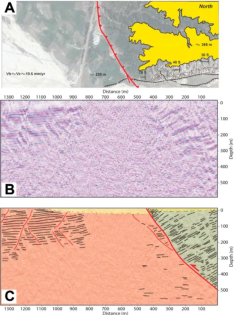
Although the deep geometry of structures along the Himalayan front is documented on a large scale by seismic lines acquired by the Petroleum Exploration and Promotion project of the Department of Mines and Geology [e.g., Bashyal et al., 1998], such lines are insufficient to provide constraints on the shallow dips of the MFT strands and hence assess shortening rates based on local uplift rates deduced from terrace elevation and dating. Therefore, we shot two shallow, 1.3 km long, seismic reflection profiles along the Sir and Ratu river valleys, which cross at high angle the Patu and Bardibas thrusts, respectively (Figure 3). Dynamite rods (100 g), buried at shallow depth (<2 m) within unconsolidated river gravel, were fired every 10 m. The blasts were recorded by 40 Hz geophones spaced 5 m apart (2 s. recording time; 48 traces; 12 nominal fold; 270 m maximum offset). Standard seismic processing included amplitude correction, geometry spreading compensation, random noise attenuation, band-passfiltering (30 Hz–95 Hz), high-precision stacking, and 2-D FX poststack time and depth migration. The seismic profiles were interpreted by integrating surface geological observations. The geometry of the thrusts at depth was then used to convert incremental amounts and rates of uplift into coseismic fault slip and slip rates.
Two complementary methods were used to determine the return times of great earthquakes. In thefirst, an average recurrence interval was derived from a number of events over a period of time covering the entire age span of the terraces, based on ourfinding that terraces abandonments were locally consecutive to great earthquakes. We also used an alternative approach taking into account the minimum, maximum, and median intervals between events as deduced from the observations at a given site, as well as from the combination of observations at all sites. The return times and associated uncertainties were then estimated from the distribution of these interseismic intervals.
Throughout our study, geomorphic/paleoseismological observations and interpretations were always compared to the regional historical earthquake catalog and to all observations, including macroseismic or geodetic evidence, documented during these past earthquakes. In the next section, we start by summarizing this historical data, which is essential to assess the size of these earthquakes.
3. Large Historical Events in Central and Eastern Nepal
According to historical accounts going back to the thirteenth century A.D., central and eastern Nepal have been shaken by about 10 destructive events [Pant, 2002], most likely sourced within the Himalayas, because they are not documented to have caused maximal damage elsewhere. Much of the information concerning these earthquakes comes from destruction described in Kathmandu and adjacent areas. We review here the evidence that concerns the largest events, based on published studies [e.g., Pandey and Molnar, 1988; Bilham, 1995] and in the light of more recently translated historical accounts [Pant, 2002; Rana, 1935].
Thefirst historical event to stand out is the major earthquake of 7 June 1255 A.D. Although it was preceded by another large earthquake on 24 December 1223, very little is known about that earlier shock because the relevant manuscript was damaged. A lot more information survived for the 1255 event [Pant, 2002]. The destruction was extreme throughout the Kathmandu valley, with one third of the population killed. Mortally wounded, King Abhaya Malladeva died 8 days after the earthquake. Perceptible aftershocks ensued for 4 months. By comparison with twentieth century events in the Himalayas, the 1255 A.D. earthquake should thus be ranked a great earthquake.
Another very large event occurred on 14 September 1344, causing also major destruction in Kathmandu and again the death of the King, this time the next day. No information, however, is available on aftershock occurrence or the total number of casualties.
The next major event to cause significant destruction in the Kathmandu valley occurred more than 575 years later, on 26 August 1833. It followed a smaller shock on 4 June 1808 that destroyed houses in Bhaktapur (Kathmandu valley) though little more is known about that earthquake [Pant, 2002]. The 1833 event struck at night (11 h, 55 min P.M. Calcutta time) and was preceded by two strong foreshocks, 5.5 h and 25 min earlier [Campbell, 1833a, 1833b; Bilham, 1995]. The main shock lasted for about 1 min and caused ample swing of the trees, with undulatory, NE-SW oriented vibrations and noises perceived as coming from the east or northeast. In Kathmandu, many houses fell or were leveled to the ground, and many temples were destroyed [Campbell, 1833a, 1833b]. The total number of fatalities in the valley, though uncertain, appears to have been about 500 and was probably minimized by the occurrence of the two big foreshocks. There were six
strong aftershocks in the next hour and 20 more the next day. Aftershocks continued to be felt during 3 months, up to 26 November 1833. The effects of the earthquake reached far from the Kathmandu valley, with significant damage to houses at Monghyr (Bihar state—India) and other cities in the Ganges plain, as well as in the Gyirong area to the North. The Kamala River was reportedly dammed for 4 days by a rock slide. According to Ambraseys and Douglas [2004], based on 61 macroseismic MSK64 intensity data points, the surface area within isoseist VIII (MSK64) was 2300 ± 880 km2, a value reassessed at 2500 ± 1600 km2by [Sapkota, 2011]. The estimated Mw_macroseismicmagnitude—deduced from the macroseismic data available— for this event is thus 7.7 ± 0.2 [Bilham and Wallace, 2005], somewhat greater than the value (7.6) assessed by Ambraseys and Douglas [2004]. The contoured isoseismal VIII region lies entirely between 85.2°E and 86°E and between the city of Kathmandu and southernmost Tibet, implying an epicenter located N-NE of Kathmandu (Figure 2). Although the magnitude was recently lowered to 7.3 ± 0.1 by Szeliga et al. [2010] and the epicenter inferred to have been 80 km S-SE of Kathmandu, this latter location is not in agreement with the extent of destruction north of Kathmandu into South Tibet and with the NE provenance and polarization of the oscillations felt during the main shock [Campbell, 1833a, 1833b].
Another large earthquake occurred 33 years later, on 23 May 1866, around 15 h, 35 min Calcutta time. While a significant portion of Kathmandu was reportedly destroyed and this shock was felt in the Gangetic plain as well as in Darjeeling [Oldham, 1883], with one house collapse at Monghyr (Bihar state—India) [Martin and Szeliga, 2010], it was clearly smaller than the 1833 earthquake. The Mw_macromagnitude estimated by Szeliga
et al. [2010] is 7.2 ± 0.2.
Since then, the last and only major earthquake that affected Kathmandu is the great, 15 January 1934 event, the unique instrumental entry of the catalogue. Its effects were extensively documented in India and Nepal, generating abundant reports (e.g., in Roy [1939] and Rana [1935]). This earthquake is described in the dedicated section below.
4. The Great 1934 Earthquake
The great 1934 Bihar-Nepal earthquake occurred at 2:24 P.M. Nepal time on 15 January. Many accurate and deeply moving details of the people’s reactions during the shaking were reported by Bhrama Shumsher Rana, a military officer responsible for the rescue operation and reconstruction, in his book “Mahabukampa”—the great earthquake—[Rana, 1935], see Appendix A.
Following the shaking, major destruction was reported in Kathmandu as well as in the valley, with the cities of Bhaktapur, Patan, and Lubhu being nearly leveled to ground while the Nagarjun royal palace was destroyed. But the damage went far beyond the Kathmandu valley. B. S. Rana collected many testimonies of devastation in eastern Nepal. Among them, the major destruction in villages of the Bhojpur district is particularly representative of the violence of the main shock there. The ground in this area, as pulled and compressed, was torn by innumerable cracks. In addition, landslides affected all surrounding mountains. The large amounts of dust spread in the air were so dense that witnesses could not see anything around during half an hour. When the dust dissipated, Bhojpur bazaar was reduced to a desert heap of ruins. Catastrophic landslides and rockslides triggered by the earthquake were not restricted to the Bhojpur area but extended along much of the east Nepal Himalayan front, particularly between Udayapur and Dharan (Figure 2). Moreover, the devastation was not restricted to the eastern Nepal hills and mountains. Widespread geological effects of the earthquake were spectacularly documented in the Terai plain and in Northern India [e.g., Dunn et al., 1939]. A 300 km long region of Bihar, dubbed the“slump belt,” was strongly impacted by liquefaction and slumping. This, combined with elastic strain during the event, resulted in tens of centimeters of regional subsidence (locally up to a meter), measured by leveling shortly after the earthquake [Bomford, 1937; Bilham et al., 1998], (Figures 2a and 2b). Although the slump belt was long thought to reflect faulting beneath the Gangetic foreland, either on a blind, shallow-dipping decollement [e.g., Seeber and Armbruster, 1981], or on a deeper, steep basement fault [e.g., Kayal, 2010], (Figure 1b), it has been recently interpreted as the result of focusing of the SmS wave phases [Hough and Bilham, 2008]. This latter interpretation, together with the subsidence in the foreland, is in keeping with a scenario in which the causative fault of the 1934 Bihar-Nepal earthquake was in Nepal, as pioneered early on by Rana [1935], and then gradually constrained to be the Main Himalayan Frontal Thrust [Pandey and Molnar, 1988; Bilham et al., 2001; Avouac et al., 2001; Sapkota et al., 2013].
Overall, landslides and the collapse of buildings were fatal to more than 15,000 people. More than 8000 victims were identified in Nepal, including two of the King’s daughters and one of the prime minister’s. The number of wounded is estimated at several tens of thousands [Rana, 1935]. More than 7000 victims were counted in Bihar. It is possible that the former number was underestimated because of missing data in remote mountainous areas. On the other hand, given the violence of the shaking and the surface area impacted, the total number of victims was probably—and fortunately—minimized by the occurrence time— 2 P.M. on a festive day—when many were enjoying the outdoors [Rana, 1935].
Unlike the 1833 event, the 15 January 1934 earthquake had no reported foreshock. Aftershocks were widely felt throughout the epicentral area, in rapid succession for thefirst 2 days, then in steadily decreasing number during thefirst month. Additional events were still felt and reported by the population during the first 5 months and instrumentally recorded for about 20 months after the main shock, ceasing completely at the end of 1935. Although the duration of felt aftershocks was similar to that reported in 1255, the 1934 earthquake had many fewer aftershocks than either the 1905, 1950, or 1897 earthquakes, possibly because it ruptured a simpler, more mature fault.
The individual testimonies and official macroseismic questionnaires collected after the event have been translated into macroseismic intensities (MMI) [Dunn et al., 1939], [MSK64: Ambraseys and Douglas, 2004], (EMS98) [Martin and Szeliga, 2010]. Whatever the scale chosen, the earthquake qualifies as a very large event. The area affected by intensities I≥ VII appears to be larger than 100,000 km2. Local site effects notwithstanding the zone impacted by the greatest destructions and encompassed by the isoseismal I≥ VIII, which is commonly correlated with the length of the earthquake rupture, is more debatable, given the sparse macroseismic data set available in eastern Nepal. However, the data delineate a roughly oval-shaped surface area> 10.000 km2, extending from the foot of the High Himalayas to the Terai plain and crossing the MFT near Bardibas and east of Dharan (86–87.6°E and 26.6–27.7°N) (Figure 2).
The macroseismic magnitude estimated by Ambraseys and Douglas [2004] is Mw_macrosesmic= 8.1. But the
instrumental magnitude generally assigned for the 1934 Bihar-Nepal earthquake has been 8.4, with most articles referring to C. Richter’s determination of a “revised magnitude” (“M”) [Richter, 1958]. This magnitude was refined (by Richter) in Geller and Kanamori [1977], who determined a body wave magnitude (mb) of 7.8 and a surface
wave magnitude (Ms) of 8.3, both confirmed by Abe [1981, 1984]. Chen and Molnar [1977] determined the
seismic moment of the event by estimating the spectral density of the Rayleigh and Love wave at long periods. They concluded on a moment magnitude (Mw) of 8.0 before revising it at Mw= 8.4 [Molnar and Qidong, 1984].
Overall, the geological effects and seismological source parameters of the 1934 event imply that it was a great earthquake and that slip occurred on a 150–300 km long stretch of the MFT in eastern Nepal (Figure 2).
5. Regional Tectonic Geomorphology of the Siwalik Front in the Ratu Nadi Region
It has long been known [e.g., Upreti, 1999] that crustal shortening in the Himalayas has been principally absorbed by a south younging sequence of four main thrust systems, namely, from north to south, the Tethys Himalayan thrusts, the Main Central Thrust, the Main Boundary Thrust, and the Main Frontal Thrust (MFT), which separate, respectively, the Tethyan passive Indian margin sediments, the High Himalayan crystallines, the metasedimentary Lesser Himalayas, the Siwalik molassic sandstones—deposited in the Neogene foreland basin of the range—, and the deposits filling the present Indo-Gangetic foreland basin. These thrusts are often interpreted to merge at depth into a single decollement, the Main Himalayan Thrust [e.g., Pandey et al., 1995; Cattin and Avouac, 2000].
Only the youngest, southernmost thrust (MFT) appears to be active in central Nepal, with the basal decollement absorbing up to about half of the convergence between India and Asia. Large patches of the decollement interface, which is generally locked—as presently—from the surface to beneath the front of the High Himalayas over a distance of more than 80 km [Ader et al., 2012] rupture during great earthquakes that release the slip deficit accumulated during the interseismic period. The ruptures have been inferred to propagate up to the Main Frontal Thrust, given the ~ 20 mm/yr average Holocene shortening rate accommodated there [Lavé and Avouac, 2001].
The existence of deformed terrace surfaces and superficial faulting along the Siwalik front in the Ratu Nadi area has long been established by studies based on air photo interpretation andfieldwork [e.g., Nakata, 1972;
Hérail and Mascle, 1980; Delcaillau, 1992]. Specifically, these previous authors found exposures of faults cutting youngfluvial deposits along several valleys. One such outcrop, first described by Delcaillau [1992], (diamond, Figure 3) on the Maraha river bank, in the westernmost part of the 1934 mesoseismal zone, provided a starting point for more detailed work, including lateral refreshing and trench excavation [Lavé et al., 2005]. The resulting paleoseismological logs were interpreted to reveal the occurrence of one great medieval event (~A.D. 1100), but to show no trace of a rupture in 1934.
Eastward, between the Maraha and Ratu Rivers, the MFT surface trace splits into two distinct strands with very sharp geomorphic expression (Figure 3). Regionally, along the Siwalik front, this is one of the areas where steep cumulative tectonic scarps and multiple, uplifted, inset terraces are most prominent and best preserved (Figures 3–5). These telltale features are clear on all remote sensing images, from Landsat Thematic mapper to High-Resolution scenes (Ikonos, Quickbird), as well as on 1964 air photo swaths and 1/25,000 topographic maps, making the area a target of choice for morphotectonic studies. We thusfirst focused our search on this area—mapping in detail tectonic structures, terrace surfaces, Quaternary fault scarps, and fluvial risers (Figure 5) and then quantifying further the tectonic geomorphology at three sites selected for paleoseismological investigation.
5.1. Terrace Morphology and Relative Elevations
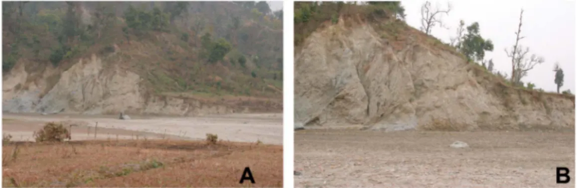
Between the village of Bardibas and the Ratu River, the south facing cumulative escarpment of the southern strand of the MFT (Bardibas Thrust) bounds abandoned hanging wall terraces with a range of different elevations (Figures 4 and 5). Along the river, there are at least four distinct, asymmetric terrace levels just north of the thrust. The highest one, to the west, with deep, forested incisions, is the Gauribas terrace surface (T4), 40 to 45 m above the riverbed (Figures 4 and 5). On the east side, the Tulsichauda surface (T′3) stands somewhat less than half as high. Two more low-level terraces are visible in the river valley, the lowest of which (T′1) is still high enough (up to 2 m) to shrink the floodplain width by half as one crosses the thrust trace from footwall to hanging wall (Figures 4a and 5). Where best exposed just north of the thrust along the high risers of the Ratu Nadi, the hanging wall terraces are fairlyflat straths, made of pebbles and gravel unconformably capping south dipping Mid-Siwalik beds of sandstones/siltstones with microconglomerate horizons (Figure 4b). Along the T4/T2 riser, the Siwalik dips increase toward the thrust from ~ 40° to ~ 70° in a distance of less than ~ 200 m (Figure 6a), implying that the hanging wall ramp anticline beneath the terraces (Figure 5) is a south vergent fault propagation fold. This inference is confirmed by the near vertical attitude of Siwalik beds beneath T′3 north of Thapatol (Figure 5). Likewise, along the Patu thrust, northern strand of the MFT, there areflights of abandoned terraces, as well as riverside exposures of north dipping thrust faults cutting shallow pebble beds and reaching close to the ground surface [Delcaillau, 1992].
In thefield and on air photos, we could map as many as seven main regional levels of terraces in the area shown in Figure 5. The highest terrace surface (T5) stands uplifted ~ 70 m above thefloodplain of the main river, the Ratu Nadi. Locally, there may be more subterrace levels, while southward on the footwall, surfaces of
Figure 4. (a) Helicopter view (toward north) of Bardibas strand of MFT. Thrust escarpment, just north of road, sharply limits Gauribas terrace (T4),≈ 40 m above present day Ratu riverbed. Note free-faced top of escarpment and fresh scree colluvial slope beneath. Retreating gullies in deeply incised, forested valleys deposit small fans at foot of escarpment. White box locates photograph in Figure 4b. (b) Photograph (toward west, from Ratu riverbed) of unconformable gravel of Gauribas strath terrace on 30°S dipping middle Siwaliks mudstones and conglomerates.
different ages likely merge or mingle within the Terai foreland, which is a bajada of coalescent fans (Figure 3). While the relative ages of such terraces, based on height above the local riverbed, is not in doubt at the sites we visited, correlations into areas that are forested, hence difficult to inspect with air photos or high-resolution (HR) satellite images, remain tentative. Correlations upstream or downstream in the river valleys or from valley to valley are also somewhat uncertain. This is because a single terrace tread can be emplaced diachronously along one stream [e.g., Bull, 1991]. Besides, two terraces of identical relative heights in adjacent
Figure 6. Photographs (toward ENE and E, respectively) of river cut and cumulative scarp of MFT Patu strand in Sir Khola valley, as initially observed in 2008. Four north dipping thrusts are visible in steep east bank cliff. See detailed mapping of refreshed exposure in Figure 8.
Figure 5. Geomorphic and neotectonic map of Bardibas/Dhalkebar area. See text for discussion of relative ages of Quaternary terraces, and of 3-D geometry of the thrust system.
valleys whose rivers have different catchments may be of slightly different ages. The main inference underlying regional correlation is that the ages of local terrace emplacement and abandonment, which result chiefly from climate change and tectonically driven vertical motion—both ultimately timed by global processes—should not vary much spatially over tens to hundreds of kilometers. Conversely, terrace ages then provide key information on both processes, as shown elsewhere in the Himalayas [e.g., Lavé and Avouac, 2001] or in other active tectonic regions of central Asia [e.g., Van der Woerd et al., 1998, 2001; Mériaux et al., 2012, 2005; Chevalier et al., 2005]. Clearly, the correlative,first-order, terrace ages represented by specific colors in Figure 5 should thus be regarded only as tentative.
In the Bardibas area, the terrace emplacement and abandonment chronology was largely unknown when we started this study. However, the highest terrace between the Patu and Bardibas thrusts (T5), 70 m above the present-day river bed, had already yielded a rich macrolithic Mesolithic industry. Some of the mesolithic artifacts were found embedded in a red soil developed within the upper part of alluvial silt capping the terrace, hence probably emplaced shortly before or after terrace abandonment [Corvinus, 1987, 1989; Corvinus, 2007; Gaillard et al., 2011]. The silt deposition was14C dated by these authors at ~ 7 ka B.P. with charcoals sampled in this soil horizon. This provides an upper bound for the ages of all terraces, which thus span much of the late Holocene. The tentative ages indicated in the caption of Figure 5 are based on the simple inference of a constant relative uplift rate during this time span, which we discuss later in the light of the new ages we obtained with our own charcoal samples at the different sites we investigated.
5.2. Relationship With Underlying Tectonic Structures
The simplified structural map of Figure 3 combines our own observations (Figure 5) with features documented in the Geological Map of Petroleum Exploration [Pradhan et al., 1996] that covers much of the Frontal Himalayas in central and eastern Nepal. The overall regional structure helps understandfirst-order links between active faulting and fold growth along this stretch of the Siwalik Hills.
West of Bardibas, the multiple scarps that splay northwestward from the principal escarpment of the MFT’s south branch (Figure 5) appear to bound the periclinal termination of the Aurahi ramp propagation anticline whose hinge is clearly outlined by Mid-Siwalik sandstone beds north of Lalgadh and Bardibas. Though active shortening along the Bardibas thrust extends past the Bhabsi Nadi, this is where the abraded Mid-Siwalik anticline apex stops, giving way westward to shallower and gentler folding of more recent upper Siwalik and Quaternary beds. The splay scarps long identified by Nakata [1989] may thus follow tear/transfer faults, possibly connecting the Bardibas thrust with a deeper, oblique ramp beneath the Patu thrust.
The south branch of the MFT continues to be marked westward past Thapatol by a more modest cumulative scarp that can be traced across the Jhanga Khola, where it is still 15 m high, to at least the Gadanta Khola valley (Figures 3 and 5). The associated ramp anticline similarly continues westward. Along both the Jhanga and Gadanta Rivers, high risers expose exhumed red claystones and conglomerates belonging to the Uppermost Siwalik formation, which is therefore folded, albeit less because it was probably deposited unconformably upon the Mid-Siwaliks, as observed in other places on the north side of the Siwalik range (e.g., roads from Hetauda to Amlekghanj and Muksar to Udaypur Ghari). Exhumation due to folding is still clear inside the large hairpin meander of the Dhungre Khola but stops short of the Mahara Khola River. The presence of at least four levels of uplifted terraces (T2–T4) in the piedmont of the Siwaliks range front, between the Bhabsi Nadi and Dhungre Khola, is thus a simple consequence of the overlap between the two active, en echelon strands of the MFT. The sediments brought into the Patu thrust foreland by the south flowing rivers fill a gentle sag—a piggyback syncline—dammed farther south by anticlinal folding above the Bardibas thrust ramp. Yet these rivers, which maintain a uniform downstream profile while crossing the Bardibas thrust, continue to incise in tune with hanging wall uplift on that thrust. The fact that foreland folding and terrace uplift are not observed along the Mahra Khola valley indicates that the MFT’s south strand stops before reaching that valley, perhaps on a lateral ramp that transfers shortening northwestward back to the unique frontal thrust west of the river. We infer that one of the southernmost faults visible on Mahra Khola’s west bank river cut [Lavé et al., 2005] corresponds to the branching, off the MFT’s north strand, of such a transfer ramp (Figure 5).
The detailed geometry of the stepping thrust traces in map view corroborates an architecture with branching in 3-D. East of the Mahra Khola fan, the MFT’s northstrand surface trace swings 30° northeastward while
stepping back northward by 2 km, as would occur if it ramped up more steeply from a shallower-dipping thrust whose updip projection emerged along the surface trace of MFT’s south strand. The geometry of the next step, southeastward across the Ratu Nadi fan, is similar. The Bardibas strand of the MFT makes a sharp, 1 km dogleg toward the north, as if it receded from the westward projection of the next, Aurahi strand, located farther south (Figure 5). These geometrical relationships in plane view may be interpreted to reflect an imbricate fan structure [e.g., Boyer and Elliott, 1982], supporting the inference that the distinct thrust branches connect at depth. Deep, oblique thrusting with a dextral slip component would produce the right-stepping overlapping strands observed at the surface. Such deep connectivity in active thrust systems, similarly inferred elsewhere from geomorphic mapping [e.g., Meyer et al., 1998], probably favors coeval rupturing of separate surface strands during large earthquakes, as observed for instance during the 2008 Wenquan [e.g., Xu et al., 2009; Liu Zeng et al., 2010] or the 1932 Changma events [e.g., Peltzer et al., 1988]. Note that the separation between the thrust strands, here between ~ 1 and ~ 5 km, is small enough not to preclude coeval rupturing [e.g., Wesnousky, 2008].
Within the overlap between the Patu and Bardibas thrusts, the terrace tread heights above river generally increase east of the Mahara Khola, reaching a maximum along the Ratu Khola (Figure 5). This suggests that the partitioning of shortening between the two thrust strands varies along strike, due in part to their ages and dip angles, an inference we discuss later.
6. The Patu Strand
6.1. Sir Khola Valley Outlet
The northern,“Patu” strand of the MFT, or Patu thrust, forms the main topographic front of the Siwalik Hills west of the Ratu Nadi (Figure 3). Among the several narrow river gorges that incise the hanging wall (Figure 5), the Sir Khola valley outlet provided the most promising evidence of well-preserved modern faulting, coupled with a geomorphically spectacular, 25–30 m high cumulative thrust scarp with clear signs of ongoing uplift (Figure 6).
Four north dipping thrusts were visible in the 15–20 m high cliff cut by the river on its east bank (Figures 6, 7, and 8). Three of them offset thin, unconsolidated pebble beds by a few meters. One more thrust in sheared Siwaliks was abraded and capped by low-level terrace gravel. All thrust planes were outlined by dark, gouge-rich, shear zones. The detailed morphology of the escarpment transverse to the river was equally informative
Figure 7. Map of Quaternary/active tectonics and geomorphology of Sir Khola outlet (see location in Figure 3). Black line is trace of seismic profile in Figure 10 (distance, in meters, within small circles). The two white boxes are locations, respectively from left to right, of the auxiliary trench and beheaded channel shown in Figures 13a-b and 13c-d.
(Figure 7). This main cumulative scarp showed at least two distinct bevels separated by steeper slopes, with a subtler, smoother scarp cutting across the low-level strath terrace at its base and projecting to the most frontal thrust plane uplifting this strath’s gravel. This suggested the occurrence of a very recent event. Moreover, the valley of a small tributary crossing the main escarpment ~110 m east of the river stood in hanging position and wasflanked by narrow terrace benches perched yet higher (Figures 7 and 9). We thus selected this site, which, to our knowledge, had never been investigated prior to ourfirst reconnaissance, for an in depth study whose results,first discussed in [Sapkota et al., 2013] and now complemented by additional surface and subsurface evidence, are presented in greater detail below.
6.1.1. Subsurface Seismic Imaging
The 1300 m long seismic profile shot in the river valley (Figures 3, 7, and 10) images fairly clearly structures in the hanging wall and footwall as well as the positions and attitudes of shallow thrusts, down to ~ 300 m depth (Figure 10). The main, shallowest thrust, which seems to ramp all the way up to the surface (near 700 m from the origin) appears to dip variably northward, from 30 to 15° deeper down. It seems to divide complexly upward into several hanging wall splays that duplicate packages of ~ 30°N dipping Siwalik beds. Beneath this main active thrust, faulting and bulk warping of footwall strata, likely Upper Siwalik beds (Figures 3 and 5), suggest the existence of a deeper thrust/decollement, emplacing the latter upon the Terai Pleistocene fanglomerates. That deeper thrust may ramp up farther south, possibly along the scarp that extends west of Thapatol to the Gadhanta River (Figure 5).
6.1.2. Morphotectonics and East Bank River-Cut Cliff
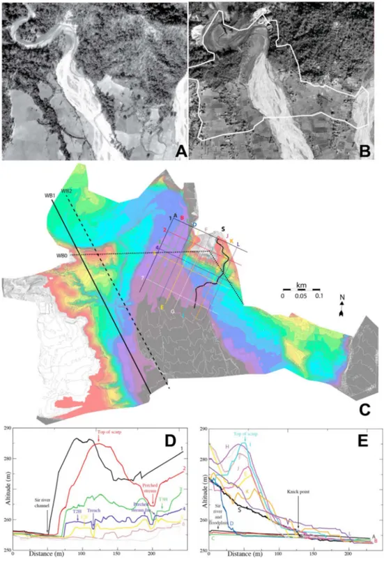
To document and quantify the relationships between thrusts and footwall/hanging wallfluvial terraces at the Sir Khola outlet, we jointly used stereo-paired, 1964 and 1997 aerial images and recent high-resolution Ikonos satellite images (Figures 9a and 9b). The precise topographic map, with a resolution of ~ 20 cm, of Figure 9c was generated from a Total Station (TS) survey covering an area of ~ 500 × 1000 m2. It was complemented by a Riegl VZ-400 Terrestrial Lidar Scanner (TLS) survey that providedfiner details on flat or steep surfaces, enabling for instance the identification of individual pebbles within strath terraces or of small braided channels in the riverbed. This helped understand deposition patterns in section and progressive shifts in map view of theflood currents that laterally cut the main meander year after year. It also helped contour the
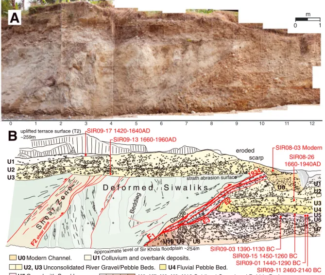
Figure 8. Refreshed, east bank river-cut cliff at Sir Khola outlet. (a) Complete photomosaic. Black box is area of high-resolu-tion Lidar DEM, interpreted in Figure 8b. (b) Simplified interpretation of Lidar DEM of river-cut face. Red lines are young active thrusts. Red numbers: calibrated calendric ages of detrital charcoal samples. Youngest terrace: yellow shade. Older terrace: orange shade. [after Sapkota et al., 2013].
steepest cliff faces within less than 0.2 m. Topographic profiles were extracted from the resulting TS and TLS Digital Elevation Models to separate and measure discrete events of incision and terrace surface uplift (Figures 9d–9g). Combining all this information with systematic, outcrop-scale geological observations in the field yielded the Quaternary tectonics and geomorphic map of Figure 7.
Figure 9. Coregistrated images of Sir Khola outlet: (a) aerial photo acquired on 16 January 1964 and (b) panchromatic IKONOS-2 image acquired on 20 January 2001. White polyline on Figure 9b marks contour of digital elevation model in Figure 9c. (c) Total station digital elevation model with location of (d and e) elevation profiles across the east bank of the river, oriented WNW-ESE and NNE-SSW, respectively as well as (f and g) elevation profiles across whole valley and west bank.
Figure 9. (continued) 100 400 300 200 100 500 400 300 200 600 700 800 900 1000 1100 1200 0 500 600 Distance (m) Depth (m) B A 100 400 300 200 100 500 400 300 200 600 800 900 1000 1100 1200 0 500 600 Depth (m)
Figure 10. (a) Depth migrated seismic profile (scale 1:1) across north branch of MFT along Sir Khola valley (location in Figure 3). (b) First-order interpretation showing, on north side, north dipping, hanging wall Siwalik beds stacked up by splays of main active thrust, which dips about 30°N and surfaces around 700 m (red arrow). Blind decollement ramping up farther south is likely responsible for folding of beds in footwall. Red lines are thrusts, dashed where inferred.
The natural river-cut cliff along the Sir Khola’s east bank was thoroughly inspected. This key outcrop is about 200 m long (Figure 7), from the couple meters of footwall gravel unearthed beneath the southernmost thrust splay (F1) to thefirst meander of the river, where over 50 m of hanging wall Siwaliks capped by fluvial terrace conglomerates have been incised. To the north, in the meander hairpin turn, the river dissects south vergent anticlines with recumbent/overturned limbs folding Mid-Siwaliks stata (light grey/white siltstones with intercalations of yellowish/dark grey mudstones), [Sapkota, 2011]. In the south, the cliff exposes monoclines of light-colored, predominant siltstones, stacked by several thrusts and intensely deformed beneath and south of the main escarpment. Our most detailed paleoseismological work targeted that frontal ~ 40 m long section, which was cleaned and refreshed several times for logging (Figures 8a, 8b, and 11).
The clearest thrusts lie beneath the cumulative escarpment (F3 and F4), and under the toe of Siwalik siltstones capped by the Th2 gravel underlying the escarpment’s south tapering colluvial wedge (F1), (Figures 7, 8, and 11). Two strath terrace gravel layers,< 1 m thick, have recorded multiple offsets by slip on the thrusts. The lowest abandoned strath terrace in the footwall (Tf2) was uplifted 3–4 m above the river by slip on F1, whose emergence coincides with the scarplet south of the main escarpment. Th2 is truncated again northward by thrust F3, near the base of that escarpment. The higher strath (Th3?) is preserved on a small bench, ~ 10 m above river, below the upper tip of F4 (Figure 8). It was truncated and uplifted by F4, at least up to the top edge of the river-cut cliff farther upstream, which stands at least 16 m above the riverbed, and possibly up much higher.
Figure 11. Frontal part of refreshed Sir Khola river-cut face. (a) Orthorectified photomosaic of gridded part of face (grid squares are 1 m on a side). (b) Simplified structural and stratigraphic log of mosaic in Figure 11a [from Sapkota et al., 2013]. Faults and calibrated charcoal ages as in Figure 8.
F1, which strikes N80°–100°E and dips 27–30°N, marks the sharpest contact between sheared, near-vertical, white Siwalik siltstones and near-horizontal, buff-colored alluvium (Figure 11). A dark, centimeter thick gouge zone forms a thrust sole at the base of the Siwaliks. Beneath are lenses of footwall conglomerates dragged upward by thrusting, separated by shallower-dipping splays. Drag is also clear from the sharp upward bending, only ~ 1 m away from the thrust, of pebble beds in the footwall (Units U7–U10 and U4–U5, Figure 11). Two splays that terminate upward at the base of different footwall units while truncating those underneath may attest to distinct seismic events (Figure 11b), as further specified below. The deepest units exposed beneath F1 (U8-10) are the most drag folded, consistent with the inference of fault motion increasing with depth. They include consolidated, clast-supported, pebble conglomerates with parallel, 10–15 cm thick beds (U10), overlain by another similar bed with a distinctive, rusty brown, oxydation color (U9). Similarly folded is the more massive, 50 cm thick conglomerate layer above (U8), with rounded cobbles and pebbles grading southward into variegated sublevels including oxidized gravel and thin yellowish silt lenses. U8 is overlain, with clear erosional contact, by a 20–50 cm thick, coarse, indurated conglomerate layer (U7) composed of poorly sorted cobbles and pebbles. Above it, Unit U6, ~ 30 cm thick, is not drag folded, though it is the shallowest unit truncated by the lowermost splay of F1. It starts with contorted sand/silt lenses including pockets of matrix-supported clasts at the base and continues upward as a clast-supported conglomerate of well-rounded cobbles and pebbles. Both U6 and U7 show inset channel substructures (Figure 11), with clearly imbricated,flat pebbles/cobbles in U6, indicative of south directed water flow. Both U8 and U6 are somewhat coarser beneath F1.
Unit U5 is markedly different. It is made of irregular, thin gravel layers interbedded with buff sand/silt lenses (<20 cm thick) including clusters of matrix-supported pebbles. The contrast between the light hue of the sands and the dark rust color of the oxidized, lowermost gravel provides a local stratigraphic marker. Four detrital charcoals found in the southernmost sand lens yielded ages between 1130 B.C. and 2460 B.C., with a
14
C age distribution suggesting deposition during or after 1390–1130 B.C. (Figure 11). The base of U5 caps the tip of the lowermost F1 splay (Figure 11), marking the horizon of one seismic event (E3), which must have occurred before 1390 B.C. In turn, Unit 5 has been strongly drag folded by motion on the next thrust splay that stops farther up, at the base of Unit U3, which thus postdates another event (E2, Figure 11). One detrital charcoal found in U3, over 1 m below the tips of the uppermost splays of F1, yielded a calibrated age of A.D. 1660–1940. This constrains the penultimate (E2) and latest earthquakes on F1 to have ruptured the surface prior to A.D. 1660 and after the seventeenth century A.D., respectively.
Units U3 to U1 in the footwall are distinctly less consolidated than those below, with loose sandy/silty matrix and lighter color. Unit 4, an unsorted gravel/pebble conglomerate with rare cobbles and a dark sandy matrix, whose base erodes U5, shows an intermediate degree of consolidation. The stratigraphy and sedimentology of U1-3 are similar to those of thefluvial conglomerates that cap the Siwaliks above F1 (see Sapkota [2011], for details). Hence, we correlate these footwall and hanging wall units and interpreted them to have been deposited coevally in the same former bed of the Sir River [Sapkota et al., 2013].
The lowestfluvial deposit on the hanging wall (U3, Figure 11) unconformably abrades and caps white Siwalik siltstones with interbedded, ~ 80° S dipping grey mudstones that are truncated by a meter-wide, north dipping shear zone (F2, Figure 11). Thisflat, 30–40 cm thick strath, now 3 m above the riverbed, is a buff-grey, mostly clast-supported conglomerate with a loose sandy/silty matrix, and rounded, locally imbricated pebbles/cobbles. It locally includes thin, southward dipping pebble/gravel horizons, implying progradation and/or channeling. The upper conglomerate layer (U2) is also mostly clast supported and unconsolidated, with a few larger cobbles, sand pockets, and variable thickness due to channeling. U2 is capped by a northward thickening wedge of soft, yellowish, chiefly colluvial deposits (U1, Figures 8 and 11), composed mostly offine silts and sands with rare, small pebbles. That wedge thickens to more than 3 m at the foot of the main escarpment and becomes coarser, with mixed Siwalik blocks and recycledfluvial pebbles (Figure 8). It clearly results from degradation of the escarpment by gravity collapse and wash. A thin arable soil caps the whole hanging wall sequence.
The six detrital charcoals dated between the base of U3 and the top of U1 (Figures 8 and 11) yielded consistent ages (A.D. 1420 to 1960) (Table 1 and Figures 8 and 11) confirming the identity of U1-3 from footwall to hanging wall. Moreover, one of the youngest charcoals, dated at 1660–1940 A.D., was sampled only a few centimeters above the T2 abrasion surface. Hence, the U3 and overlying U2 deposits on the hanging wall necessarily
postdate 1660 A.D., as they do on the footwall. That both units are offset by the uppermost splays of F1 thus demonstrates the occurrence of a large earthquake on that thrust after 1660 A.D. Detailed inspection of the toe of the thrust wedge shows that the tips of the uppermost F1 splays and parts of Unit 3 on the hanging wall and of Unit 2 on the footwall have been incised, eroded away, and then capped by thefill of a modern, shallow channel transverse to the river-cut face. The rill in that channel probably collected and drained washflowing down the main escarpment along the base of the smoothed scarplet on T2, trace of the last earthquake on F1. The depositsfilling the channel (U0) are soft silts including isolated pebbles and sands with thin, concave upward, gravel beds. One small, detrital charcoal found in the uppermost sands yielded a modern,“postbomb,” age spectrum (Table 1 and Figure 11). The last surface rupture on thrust F1 thus occurred between the early seventeenth and the midtwentieth centuries, likely during the greatest seismic event of that period, the 1934 Bihar-Nepal earthquake, consistent with Oxcal modeling of all the ages in U0-3 [Sapkota et al., 2013]. The present TLS/TS digital elevation model (DEM) elevations of the ground surfaces on the hanging walls and footwalls show that the residual height of the T2 scarplet is ~ 1.3 m, comparable to the vertical separation of the bases of Unit 3 across F1 (~1.4 m). Given the 27–30° dip, this constrains coseismic slip in 1934 to have been 2.9 ± 0.2 m. That the 1934 vertical throw is only a fraction of the height (~4 m) of Th2 above the Sirfloodplain implies that the river incised ~ 2.5 m into the footwall since the earthquake. Though only ~ 6 m north of F1, the 45°N dipping thrust shear zone F2 did not slip since deposition of Unit 3 (post 1660 A.D.), hence in 1934 (Figure 11).
The next thrust northward, F3, 21 m north of F1, is a> 12 m long shear zone cutting Siwalik beds deformed beyond recognition by many small conjugate faults, reflecting strong horizontal shortening. Up section, it kinks sharply from a dip of 10–15° to 35–40°, with its upper, steepest 3 m marked by ~ 10 cm thick gouge (Figure 8). It nearly reaches the surface close to the foot of the main escarpment, about 2 m north of the basal slope break, above the thickest part of the colluvial wedge (U1). The fault tip offsets the base of that wedge, locally a complex collapse mix of unsorted pebbles/cobbles and Siwalik blocks. Hence, as on F1, the last slip event on F3 postdated deposition of Unit 2, with a throw of ~ 2 m or more, most likely in 1934 (Figure 8). F4, most conspicuous because outlined by thin continuous gouge, dips 36°N, cutting the whole river-cut cliff face up to the escarpment slope surface, ~ 11 m above the riverbed (Figure 8). Beneath a hanging wall made of light brown siltstones with indistinct strata capped byflat fluvial conglomerates 13–16 m above river, the white Siwaliks beds in the footwall dip 17°N, parallel to a 70 cm thick, light brown indurated conglomerate horizon (Figure 8). Wedged under the tip of F4, ~ 9–10 m above river, is a meter thick layer of consolidated, oxidized pebble/gravel restingflat on abraded Siwaliks. This uplifted strath remnant, dated by one detrital charcoal at 1880–1630 B.C., correlates with Units 5 or 6–7 in the footwall of F1 (Figure 8). While slip on F4 in 1934 can neither be demonstrated nor ruled out, that thrust splay likely contributed a large fraction of the total cumulative coseismic throw on the Patu thrust strand at the Sir Khola outlet in the last 3500 years. Overall, our logging of the river-cut cliff shows that two of the four thrusts, F1 and F3, each slipped ~ 3 m during the 1934 earthquake. The resulting, total coseismic slip amount (~6 m), however, is probably a lower bound, for lack of evidence on F4 and imprecise constraints, due to scarp collapse, at the tip of F3. Additional uplift/slip estimates are discussed in a later section.
6.1.3. Paleoseismological Trenches
To better assess the lateral locations of the faults seen on the river cut, as well as extend and complement the chronology of paleoseismic events, two trenches were excavated on either side of the river: a large (main) trench on the east bank (Figures 7 and 12) and a smaller (auxiliary) trench on the west bank (Figures 7, 13a, and 13b). The 14 m long, 2 m deep west bank trench dug at the foot of the T1/Th2 riser (Auxiliary trench in Figure 7) unfortunately yielded little information on recent earthquakes. This is because, due to the proximity of the main river channel (T0/T1) and toflood abrasion on Th2, no young deposits, other than modern veneers, were found to be preserved on the hanging wall or footwall. But this“auxiliary” trench clearly exposed white Siwaliks siltstones thrust atop several units offluvial conglomerates (Figures 13a and 13b). As F1 on the east bank river cut, the ~ N40°E striking, ~ 25°NW dipping thrust fault is a sharp contact outlined by a dark, irregular, gouge-rich, hanging wall shear sole. Beneath are sheared conglomerates dragged by thrust motion and cut by several shallower-dipping thrust splays (Figures 13a and 13b) that merge downdip with the shear sole, again as observed on F1 (Figure 11). Although there is little evidence here for tight, small-scale drag-folding, realigned pebbles are visible in the topmost units (U3, U4, and U8) beneath the thrust.
The uppermostfluvial units incorporate brown pebbles/gravel and light grey pebble/sand layers (Figures 13a and 13b). U3 and U4 tectonically and/or unconformably overlay deeper conglomerate units (U5, U6, and U7), which all dip south by about 20°. While such dip may partly be of tectonic origin, it might also result from southward prograding deposition. U5 is a chiefly clast-supported, indurated conglomerate of oxidized, dark red pebbles and gravel. U6, also consolidated, is composed of buff-colored pebble/cobblesfilling small fluvial channels. U7, a much finer, light grey unit, comprises mostly thin gravel layers and light grey sand/silt lenses, with rare cobbles. We infer these three units to be rough lateral equivalents of Units 6–8 along the river cut. That the calibrated14C age (2840–2470 B.C.) of the only detrital charcoal dated in U4 (Figure 13b and Table 1) is distinctly older than that of the oldest sample retrieved in U5 on the river cut (2460–2140 B.C., Figure 11) supports this correlation. So do the older, stratigraphically ordered, calibrated14C ages obtained in U6 (4330–4050 B.C.) and U9 (6220–6050 B.C.), the deepest unit in the trench, unconformably capped by U7, that includes brown sand lenses, pebble beds, and very large, deeply oxidized cobbles with weathered rinds (Figure 13b and Table 1). That these oldest footwallfluvial deposits now stand roughly at the level of the present river channel implies that in the last 8000 years, the Sir Khola has been able to maintain a steady profile, with negligible net average incision averaged on a millennial timescale. One important consequence of this quantitative observation is that long-term incision and tectonic uplift rates in the Patu thrust hangingwall should be approximately the same (within a few percent), at least locally. It seems likely that this should also be the case in the valleys of adjacent rivers comparable to the Sir Khola.
The main trench on the east bank of the Sir Khola was excavated at the foot of the 27 m high cumulative escarpment, penetrating ~ 10 m into it, and about 30 m east of the river-cut cliff (Main Trench in Figure 7). Overall, it was ~ 43 m long and 5 m deep on average, with a 2.5 m high bench in Siwalik rocks near its northern end. To the south, the excavation was stopped at groundwater level to avoid collapse of portions of the walls. At that location, this large trench cuts through better preserved units than on the west bank. Wefirst unraveled the structure of the northern part of the trench that exposed collapse colluvium and Siwaliks thrust over a massivefluvial sequence. The uppermost 10 m of the west and east walls were thus cleaned, gridded,
Figure 12. East bank main trench, Sir Khola outlet. (top) Photo mosaic of trench western wall. (bottom) Simplified interpretative log from Sapkota et al. [2013]. Faults and calibrated charcoal ages as in Figures 8 and 11. Green numbers are calibrated calendric ages of detrital charcoal samples sampled on the east wall of the trench, projected on the west wall grid.
and logged. We subsequently studied faulting across the conglomerate/sand sequence south of the main escarpment. Although both walls of the trench were inspected in detail and sampled for charcoals, we present only the log of the west wall in Figure 12. All the units identified are labeled from top to bottom and hanging wall to footwall.
The uppermost Units 1 and 2 (U1t, U2t) arefine colluvium with a thin top soil, and silty colluvium/alluvium with only rare small pebbles, respectively. Unit 1 is continuous, smoothly mantling the slopes of the escarpment and of terrace Th2/Tf2 south of it. It thins above the base of the escarpment, while Unit 2 pinches out downward roughly at the escarpment slope break (Figure 12). U2t, whose thickness varies atop an irregular base, was deposited over two radically different units. U3t, essentially clean massive sands,fills twin channels near the base of the scarp slope. U4t is a coarse, light colored, loosely consolidated collapse wedge with a steep toe, composed mostly of unsorted, well-rounded pebbles and cobbles likely derived from terrace conglomerates perched higher on the escarpment (Figure 12). Unit 5, beneath U4t, also south dipping, is a brown to yellow mixture of pebbles/cobbles and Siwalik clasts embedded in an organic-rich clay matrix with veneers of yellowish silt. It is also a collapse wedge, with more abundant Siwalik clasts at the base and larger ones at the apex (Figure 12). It must have been fed by a free-faced scarp exhuming Siwalik beds. Both U4t and U5t appear to have fallen on a stratified sand unit (U6t), which likely filled an ~ EW trending channel along the foot of the escarpment at the time of collapse. At places, especially near the top, just beneath and north of its contact with U4t, U6t incorporates thin,finely laminated sands interbedded with organic-rich clay layers. In addition, beneath U5t, the northernmost sandy layers of U6t are distinctly interfingered with three smaller collapse wedges, only ~ 1–2 m high, that mix fluvial pebbles with large blocks of Siwaliks within a clayey matrix (U7t, U8t, and U9t) (Figure 12). The apexes of thefive collapse wedges, particularly of the lowest four (U5t–U9t), rest directly upon a steep “nose” of white to light grey Siwalik siltstones whose leading edge is brecciated and cracked. The cracks arefilled with red-brown clays, a material also found inside gaps between large Siwalik boulders and above them, on top of the trench north bench.
Figure 13. (a and b) Sir Khola west bank auxiliary trench (see location on Figure 7). Oblique, west looking photograph of trench west wall (Figure 13a) and simplified interpretative log (Figure 13b). Fault F emplaces light-colored Siwalik siltstones (beneath Th2 grass-covered strath surface) on buff-colored fanglomerate units (U3–U9). F, a shear zone outlined by dark gouge, is oriented N27 to 40°E and dips 24 to 27°NW. As on east bank river-cut face, splays of F1 extend into conglomerate units beneath. (c and d) Beheaded Mad Buffalo channel, inside Sir Khola’s meander (see location on Figure 7). Photograph of river-cut cliff beneath west side of channel (Figure 13c). Simplified, interpreted section with positions and ages (in red) of14C samples collected 6 and 7 m above riverbed (Figure 13d).