Publisher’s version / Version de l'éditeur:
Vous avez des questions? Nous pouvons vous aider. Pour communiquer directement avec un auteur, consultez la première page de la revue dans laquelle son article a été publié afin de trouver ses coordonnées. Si vous n’arrivez pas à les repérer, communiquez avec nous à [email protected].
Questions? Contact the NRC Publications Archive team at
[email protected]. If you wish to email the authors directly, please see the first page of the publication for their contact information.
https://publications-cnrc.canada.ca/fra/droits
L’accès à ce site Web et l’utilisation de son contenu sont assujettis aux conditions présentées dans le site
LISEZ CES CONDITIONS ATTENTIVEMENT AVANT D’UTILISER CE SITE WEB.
Canadian Building Digest, 1971-11
READ THESE TERMS AND CONDITIONS CAREFULLY BEFORE USING THIS WEBSITE. https://nrc-publications.canada.ca/eng/copyright
NRC Publications Archive Record / Notice des Archives des publications du CNRC :
https://nrc-publications.canada.ca/eng/view/object/?id=f41fa37c-b951-48a0-8a7f-c17ba0580094
https://publications-cnrc.canada.ca/fra/voir/objet/?id=f41fa37c-b951-48a0-8a7f-c17ba0580094
NRC Publications Archive
Archives des publications du CNRC
For the publisher’s version, please access the DOI link below./ Pour consulter la version de l’éditeur, utilisez le lien DOI ci-dessous.
https://doi.org/10.4224/40000792
Access and use of this website and the material on it are subject to the Terms and Conditions set forth at
Landslides in clays
Canadian Building Digest
Division of Building Research, National Research Council Canada
CBD 143
Landslides in Clays
Originally published November 1971 W. J. Eden
Please note
This publication is a part of a discontinued series and is archived here as an historical reference. Readers should consult design and regulatory experts for guidance on the applicability of the information to current construction practice.
Spring 1971 in the Ottawa-St. Lawrence lowlands brought with it the occurrence of large landslides. Public attention was focused, in particular, on the tragic events at the village of St. Jean Vianney in the Saguenay River region of Quebec. This landslide caused the loss of 31 lives and destroyed 40 homes in a newly developed subdivision. Another landslide almost as large occurred on 16 May 1971 along the South Nation River in Eastern Ontario and completely blocked the river for more than a mile. This landslide, fortunately, did not involve human lives and is cited to indicate that the landslide problem is a regional one and that occurrences such as that at St. Jean Vianney are not unique. Indeed, records of past occurrences reveal that the St. Lawrence Valley is one of the more active landslide areas in the world.
The stability of the clay slopes in the St. Lawrence and Ottawa Valleys has been studied for more than a decade by the Division of Building Research. Such studies have resulted in a number of research papers in which individual landslides are described in detail and various aspects of the general problem are considered. It is the purpose of this Digest to direct attention to the slope stability problem as it relates to clays and to present information on the factors that affect the stability of slopes and which must be taken into consideration in a stability analysis. Recommendations are given as to the precautions that should be taken to prevent tragedies such as those at St. Jean Vianney and Nicolet. Quebec, where in November 1955 a 7-acre landslide occurred on the banks of the Nicolet River in the centre of the village. Three lives were taken, and a school, garage, and several houses destroyed. Although the clays of the St. Lawrence valley are emphasized in this Digest, the method of analysis and the corrective measures described can be applied to clays in general.
Features of Landslides
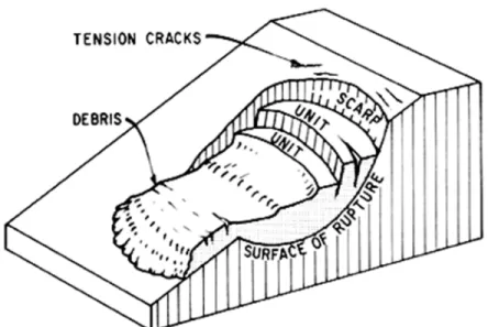
The term landslide denotes downward and outward movement of slope materials composed of natural or deposited soils. Figure 1 illustrates the main features of a landslide; the diagram indicates a very definite surface of rupture along which the material involved in the landslide moves over undisturbed material. The diagram also indicates that the surface of rupture extends to a considerable depth so that a landslide cannot be considered a surface phenomenon.
Figure 1. Illustration of a Landslide
Important factors influencing the stability of a slope are the inclination, the over-all height, the soil material, the position of the groundwater table and its structural geology (sequence of strata, slope of beds, faults or imperfections).
Stability Analysis
In the early 19th century Alexandre Collin, a French engineer engaged in canal construction, noted that the failure surfaces formed by landslides in clay along canal banks followed a curved form like that illustrated in Figure 1. In 1846 he published a memoir in which he proposed a statical method of analysis based on a curved surface and measured shear strength of the soils. Since that time various analyses have been proposed, resulting finally in the slip circle method developed by Swedish harbour engineers that forms the basis of techniques in current use. The essentials of the method are illustrated in Figure 2, in which a failure surface in the form of a circular arc is assumed. Disturbing forces are compared with resisting forces to obtain a factor of safety for each assumed failure surface. Several trials are necessary before the most critical circle for a given slope can be located. Digital computers are specially useful in this process and are widely used. In some cases the structural geology requires stability analyses based on a combination of curved and plane failure surfaces. Information required for the stability analyses falls under three broad headings:
geometry of the slope,
soil and groundwater conditions,
Figure 2. Stability analysis of slopes.
Of the three, only the geometry of the slope can be determined within close limits from ground surveys or mapping with aerial photogrammetry techniques.
Soil and groundwater conditions must be established through test drilling and exploration. Each soil stratum must be identified and an assessment made of its strength by soil testing procedures. Close attention must be given to sloping strata, fissures, or any structural feature that might influence stability. The position of the groundwater table must be established and information sought that would indicate its highest position during the year.
The stability analysis of a given slope is by no means precise. A number of assumptions implicit in the method, particularly those relating to the shear behaviour of natural soil masses, are seldom satisfied in nature. The main value of a stability analysis is that it provides a rational method by which measures to reduce the risk of a slope failure can be evaluated.
Importance of Drainage
Water drains freely from coarse-grained soils such as gravels and crushed rock. These materials can stand on slopes equal to their angle of repose. Fine-grained soils, on the other hand, do not drain freely and water has a great influence on their strength and behaviour. Because of their low permeability the flow of water through them is restricted and the pressure in the pore water can vary widely with changing groundwater conditions. Under dry conditions these soils will not fail immediately, even if cut to very steep slopes, but their stability does decrease with time. The shear forces that exist within a slope must be resisted by a shearing strength if the slope is to remain stable. Porewater pressure, determined by the position of the groundwater table, has a direct influence on the apparent shear strength developed by the soil; the higher the porewater pressure the smaller the shearing resistance. Indeed, even with granular soils, if the normal free drainage is blocked by conditions such as those imposed by a frozen face of soil, water pressure could rise to such an extent that unstable conditions would result. Thus drainage or position of the groundwater table has a direct influence on the stability of a slope.
There are two points to be made concerning soil conditions. The first is that the most critical slope stability problems usually occur with fine grained soils, particularly clays. This is partially due to the fact that they are difficult to drain and that the process of erosion by streams and wave action in such soils leaves many slopes on the point of failure.
The second point concerns the behaviour of the fine grained soils when they are involved in an earth movement. They may lose a significant portion of their strength upon remoulding. The degree of loss is termed sensitivity, with high sensitivities denoting a great loss in strength. Referring to Figure 1, the debris of a landslide in highly sensitive soils may not remain at the foot of the slope but spread out and move away from the slope. At St. Jean Vianney the extremely sensitive soil liquefied completely and more than six million cubic yards flowed down a stream course to the Saguenay River. Hence fine grained soils which are sensitive to remoulding need special attention with regard to slope stability.
Causes of Landslides
Landslides occur in slopes oversteepened by the process of stream or wave erosion or by the activities of man in grading slopes. In many instances oversteepened slopes stand in apparent stability until abnormally high groundwater conditions occur, thus reducing the shear resistance and triggering the landslide. For example, the winter of 1970-71 brought a record snowfall to the St. Lawrence Valley and the spring melting period occurred rather slowly, allowing the maximum infiltration of water into the soil. Once a slope in a sensitive soil has been oversteepened by erosion at the toe or by excavation work and the groundwater table is high, the stage is set for a landslide to occur. The landslide may be small, involving only a few tens of cubic yards of material and be unnoticed (Figure 3a), or it may be large enough to dam or divert a stream temporarily (Figure 3b). Very occasionally, when special conditions are present, very large landslides or earthflows such as are cited in the introduction will occur.
Figure 3. Landslides on Breckenridge Creek. (a) View of two small landslides that occured in spring of 1969. (b) Aerial view of earthflow involving 30 000 cubic yards of clay that occured on opposite bank in April 1963.
Stabilizing Measures
Stability of existing slopes can be improved by three basic methods: control of groundwater, over-all flattening of the slope, and the prevention of erosion at the foot of the slope.
Measures taken to improve drainage will be beneficial. Ditches and underground drains should be constructed to prevent the accumulation of surface water above the top of the slope. Measures should be taken to prevent erosion by such ditches.
If it should become necessary to conduct earth works near a slope, such work should always be directed towards improving the stability moments, as shown in Figure 2. Weight added to the foot of the slope increases the stabilizing forces, as does material removed from the crest. In dealing with a natural bank, it is specially important not to excavate material from the foot of the slope; and in placing fills or berms at the foot of the slope the materials used should be free draining so that the level of the groundwater table is not raised.
Erosion control is a very effective means of maintaining slopes that have either a stream or body of water with significant wave action at their foot. Such erosion can be controlled by rip-rap, a rock berm or a small revetment wall along the bottom of the slope.
Concluding Remarks
Natural slopes that have remained stable for centuries occasionally fail with catastrophic consequences as a result of slow environmental changes. Sometimes the changes are accelerated by construction activities. Steeply cut slopes may remain stable for a few years but fail suddenly under changing conditions.
The stability of a slope cannot be predicted with precision, although a reasonable assessment of an area can be made by an experienced geotechnical engineer on the basis of a thorough site investigation. Such an investigation requires analysis of soil and groundwater conditions coupled with a study of the local geology, including existing stable and unstable slopes.
Whenever an area is proposed for development the local municipal authority should ensure that it is safe from possible landslides. Natural clay banks as low as 20 feet with an inclination of only 1 on 4 should be examined for stability. In all cases expert assistance should be obtained
at the outset so that planning, zoning and corrective measures, if necessary, can be carried out at a very early stage of development.