HAL Id: hal-00305606
https://hal.archives-ouvertes.fr/hal-00305606
Submitted on 17 Jan 2007
HAL is a multi-disciplinary open access
archive for the deposit and dissemination of
sci-entific research documents, whether they are
pub-lished or not. The documents may come from
teaching and research institutions in France or
abroad, or from public or private research centers.
L’archive ouverte pluridisciplinaire HAL, est
destinée au dépôt et à la diffusion de documents
scientifiques de niveau recherche, publiés ou non,
émanant des établissements d’enseignement et de
recherche français ou étrangers, des laboratoires
publics ou privés.
hypoxia: Part II
E. C. Krug, K. Merrifield
To cite this version:
E. C. Krug, K. Merrifield. Marine modification of terrestrial influences on Gulf hypoxia: Part II.
Hydrology and Earth System Sciences Discussions, European Geosciences Union, 2007, 11 (1),
pp.191-209. �hal-00305606�
© Author(s) 2007. This work is licensed
under a Creative Commons License.
Marine modification of terrestrial influences on Gulf hypoxia:
Part II
E.C. Krug and K. Merrifield
Illinois State Water Survey, 2204 Griffith Drive, Champaign, IL, USA 61820 Email for corresponding author: [email protected]
Abstract
This study examines potential marine modification of two classes of terrestrial influence on Gulf hypoxia: (1) the flow of nutrient-rich water from the Mississippi/Atchafalaya River Basin and (2) the massive physical, hydrological, chemical and biological change associated with the Atchafalayas partial capture of the Mississippi River. The latter involves repartitioning of a total flow of about 20 000 m3 sec1, equal to that
of 13 Nile Rivers, and a sediment load of 210 million metric tonnes yr1,nearly 20 times that delivered by all of the rivers of the East Coast of
the USA. Also involved is the loss of hundreds-to-thousands of years of stored nutrients and organic matter to the Gulf from enormous coastal wetland loss. This study found that the oceanography of the Gulf minimises the impact of both classes of terrestrial influence from the Mississippi River and its nearby estuaries on Gulf hypoxia. Oceanographic conditions give events associated with the Atchafalaya River a disproportionately large influence on Gulf hypoxia. A truly holistic environmental approach which includes the full effects of this highly dynamic coastal area is recommended to better understand and control Gulf hypoxia.
Keywords: Gulf of Mexico, hypoxia, nutrients, geology, oceanography, cabbeling, boundary current, Mississippi Trough; dissolved oxygen
Introduction
This contribution builds upon a companion study (Krug,
2007) by applying a Gulf of Mexico perspective to the
hypoxic zone; in relation to how the Gulf processes inputs
from the Mississippi/Atchafalaya River Basin (MARB) and
coastal change, and the extent of the northern Gulf of
Mexicos interaction with coastal change. In doing so, the
assumptions used to define the Gulf hypoxia problem are
examined further. To expand understanding of the causes
and controls of Gulf hypoxia beyond MARB inputs and
coastal change, an oceanographic perspective is applied to
examine potential marine controls of terrestrial influences
on Gulf hypoxia. The roles of oceanic, Gulf-wide and local
currents, and their interactions with and within the hypoxic
zone and with terrestrial inputs of water, nutrients and
sediment, are examined using published literature, studies,
compilations of data and satellite imagery.
Background
The National Science and Technology Councils Committee
on Environment and Natural Resources (CENR) and others
identify input of nutrient-rich water from the Mississippi/
Atchafalaya River Basin (MARB) as the prime cause and
means of control of hypoxia in the northern Gulf of Mexico
(Turner and Rabalais, 1991; Rabalais et al., 1999; CENR,
2000). Gulf hypoxia forms during warmer months when a
warmer and less saline surface water layer develops,
enabling organic matter decay to deplete dissolved oxygen
(DO) in underlying water to £ 2 mg O
2L
1. Such hypoxic
bottom water DO values have been occurring in continental
shelf waters between the Mississippi River to at least the
Texas border (Fig. 1). Hypoxia is lethal to many species of
desirable aquatic and marine organisms (Rabalais et al.,
1999), although nutrient inputs can also enhance fishery
production in adjacent coastal waters (Diaz and Solow, 1999).
The annual occurrence of an apparently regional seasonal
hypoxia in the northern Gulf of Mexico was noticed by
environmental monitoring and research programmes starting
with the 1973 flood of the Mississippi and Atchafalaya rivers
(Fucik, 1974; Ragan et al., 1978; Bender et al., 1979;
Oetking et al., 1979a,b; Bedinger et al., 1981; Harper et al.,
1981; Gaston, 1985; Rossignol-Strick, 1985; Pokryfki and
Randall, 1987). Since 1985, the US government has
supported a Gulf hypoxia monitoring programme; its
officially-reported size is that measured during the
programmes mid-summer cruise. In response to the
doubling of the average extent of Gulf hypoxia starting with
the 1993 flood, a Watershed Nutrient Task Force was formed
to solve the Gulf hypoxia problem (Mississippi River/Gulf
of Mexico Watershed Nutrient Task Force, 1997; 2001;
Krug, 2007).
The following assumptions have been used to predict the
effects of the MARB on Gulf hypoxia. Oxygen-consuming
organic loading is from net algal productivity, the amount
of which is dependent upon nitrogen (N) from the MARB
(Turner and Rabalais, 1991; Doering et al., 1999; Goolsby
et al., 1999; Rabalais et al., 1999). Although inputs of
atmospheric and oceanic N are acknowledged, the response
of net primary productivity has been calculated to be directly
proportional to N loading and N loading from the MARB.
The N in all of the flow of the Atchafalaya River and 53
percent of the flow of the Mississippi River supports this
algal growth (Turner and Rabalais, 1991; Rabalais et al.,
1999, p. 35). Using the assumed MARB N loading and the
290 g C m
2yr
1productivity figure that Sklar and Turner
(1981) determined for water just offshore of the Barataria
Bay estuary as the net primary productivity for 106 866 km
2of the entire Louisiana/Texas continental shelf water west
of the Mississippi, Turner and Rabalais (1991) estimated
that N recycles about four times per year to support algal
growth. This N recycling estimate has been retained
(Rabalais et al., 1999, p. 87) even though the 290 g C m
2yr
1estimate is no longer considered representative (Rabalais
et al., 1999, p. 62) 122 g C m
2yr
1has come to be used
for the eastern part of the hypoxic zone off the Mississippi
River (Justic et al., 1997; Rabalais et al., 1999, pp. 8185).
Subsequently, the Watershed Nutrient Task Force
developed the Action Plan for Reducing, Mitigating, and
Controlling Hypoxia in the Northern Gulf of Mexico. The
Action Plan calls for a 30 percent reduction in MARB
nitrogen (N) discharge to the Gulf to reduce the aerial extent
of Gulf hypoxia from the then most recent 5-year running
average of ~14 000 km
2to a 5-year running average of less
than 5000 km
2by 2015 (Mississippi River/Gulf of Mexico
Watershed Nutrient Task Force, 2001). The Watershed
Nutrient Task Force recognizes that significant uncertainties
remain and there is need to reduce these to improve
management options. Thus, room for improvement is
planned with reassessment and the development of a new
Action Plan every five years (Mississippi River/Gulf of
Mexico Watershed Nutrient Task Force, 2001); however,
the deadline has since dropped back to December 2007.
Since the 2001 Action Plan there has been increased
emphasis added to MARB phosphorus (P) as a nutrient of
concern in controlling Gulf hypoxia (e.g. Justic et al.,
2003a,b, 2005; USEPA, 2004) and also a recognition that
the northern Gulf of Mexico itself has become inherently
more sensitive to hypoxia formation (Stow et al., 2005). A
history of the above institutional focus on the causes and
control of Gulf hypoxia is provided by Krug (2007) who
noted that during the time within which Gulf hypoxia has
been observed to develop there has been essentially no
overall increase in MARB inputs of water, N, and P (Turner
and Rabalais, 1991; Rabalais et al., 1999; Goolsby et al.,
1999; CENR, 2000: Kelly et al., 2001; Krug, 2007). But
there has been another kind of change. The Gulf environment
in which Gulf hypoxia is contained is undergoing massive
physical, hydrological, chemical and biological change
associated with the Atchafalayas partial capture of the
Mississippi River involving a total flow of about 20 000 m
3sec
1(Goolsby et al., 1999, p. 2) which is equal to that of 13
Nile Rivers (Wright and Coleman, 1973; Ludwig et al.,
1996) and a sediment load of 210 million metric tonnes yr
1,
nearly 20 times that delivered by all of the rivers of the East
Coast of the USA (Curtis et al., 1973). As detailed in the
companion study (Krug, 2007), this type of immense
river-switching, delta-building event occurs here about once a
millennium. Such coastal environmental change, which
includes repartitioning of MARB inputs, is capable of
inducing even persistent anoxia, year-round total loss DO,
and has done so prior to European settlement of the MARB.
This study adopts an oceanographic perspective to examine
potential marine controls of terrestrial influences on Gulf
hypoxia.
Results and discussion
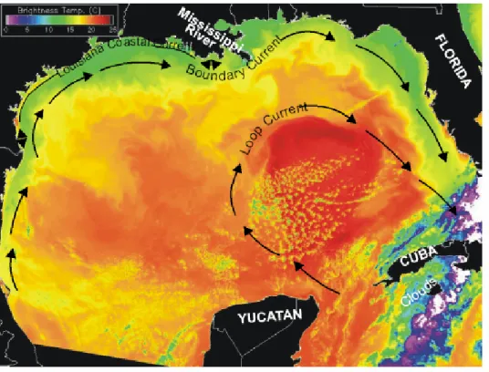
BOUNDARY CURRENT EFFECTSMarine and MARB Nitrogen
The northern Gulf of Mexico has a Boundary Current
flowing along its margins which strongly interacts with the
hypoxic zone (Figs. 1 and 2). Such boundary currents occur
along the margins of marine basins throughout the world.
In the northern hemisphere the Earths rotation deflects
currents clockwise, these currents being naturally strongest
in the west and weakest in the east (Greenspan, 1962;
Fig.2. The measured extent of hypoxia in 2002 (Louisia Universities Marine Consortium, 2000) in the northern Gulf of Mexico (Space Science
and Engineering Center, 2002). Contour depths are in metres. See figure description in the Appendix.
Fig. 1. Sea surfae temperature image of the Gulf of Mexico Loop and Boundary currents. See figure description in the Appendix.
HYPO
XIC
ZO
NE
TX
LA
MS
River Atcha fala ya R iver M iss issipp i 200 300 100 80 60 40 20 Te rrebonne Bay Barataria Bay M iss issi ppi T roug h 80Pickard, 1979). For example, a boundary current exists in
the North Atlantic Ocean and the Gulf of Mexicos Loop
Current (Fig. 1) is a branch of the North Atlantic Oceans
Western Boundary Current. It enters the Gulf of Mexico by
flowing north past the Yucatan, turning clockwise within
the Gulf, and extends eastward through the Florida Strait
between Florida and Cuba. The Loop Current reinforces
the Gulfs Boundary Current (Fig. 1), annually cycling 230
million metric tons NO
3-N through the Gulf of Mexico
(Blaha and Sturges, 1978). The MARB supplies an average
of 1.6 million metric tons N yr
1to the Gulf (CENR, 2000).
Generally, this nutrient-bearing Loop Current water
maintains a higher salinity, forming a vertical salinity
gradient (pycnocline). The Gulf-wide pycnocline is taken
to be 200 m; pycnocline depths of less than 200 m indicate
net upwelling, > 200 m net downwelling. The pycnocline is
159 m for the Louisiana shelf and rises at times to above
19 m around the mouth of the Mississippi River (Blaha and
Sturges, 1978). For example, Govoni and Grimes (1992)
measured the upwelling of nutrient-containing high salinity
water (> 36 g kg
1) to less than 8 m depth just off the mouth
of the Southwest Pass the main source of Mississippi
River water to the hypoxic zone.
There is an appreciable N flux through the Gulfs surface
layer above the pycnocline; this flux is estimated to be about
120 million metric tons NO
3-N yr
1. It is estimated that N
upwelled from the deep layer below the pycnocline
contributes 25 percent of biologically-utilised N in the top
10 m of the Louisiana shelf water (Walsh et al., 1989) and
later study found that only 40 percent of N in water of the
continental shelf here is from terrestrial sources of all origins
(Lopez-Veneroni, 1998). Whereas MARB N is used in
calculating net primary productivity and a recycling rate of
N in the 106 866 km
2of continental shelf water west of the
Mississippi to the Mexican border, the presence of
appreciable marine N points for the need to include marine
N in calculations involving Gulf hypoxia. Indeed, the
following factors indicate that the Walsh et al. (1989)
estimate of marine N contribution is underestimated. Their
upwelling estimate assumes the Loop Current is the
circulation driver of the Gulf. However, the Gulfs Western
Boundary Current is stronger than that induced by the Loop
Current. The Gulf of Mexico has a latitudinal range large
enough to set up its own Western Boundary Current
(McLellan, 1965; Huang and Goodell, 1970; Sturges and
Blaha, 1976; Pickard, 1979, pp. 134158; Cho et al., 1998;
Wiseman and Sturges, 1998). Indeed, even estuaries the size
of Chesapeake Bay are reported to have such circulation
(e.g. Fischer et al., 1979, p. 237). The Gulfs
latitudinally-driven Western Boundary Current is strengthened by the
Loop Current as well as by the prevailing winds of the
Bermuda High, the latter making the Gulfs Western
Boundary Current strongest in summer. It also results in the
reversal of the western flow of the Louisiana Coastal Current
the thin band of coloured water inshore of the hypoxic
zone in Fig. 2 and too small to be seen on the scale of the
Loop and Western Boundary Currents in Fig. 1 to the
east (Kutkuhn, 1963; Blaha and Sturges, 1978; Temple and
Martin, 1979; Bedinger et al., 1981; Crout and Hamiter,
1981; Halper et al., 1988; Dowgiallo, 1994; Martinez-Lopez
and Pares-Sierra, 1998; Wang et al., 1998; Vidal et al., 1999;
Chen et al., 2000; Ohlmann et al., 2001; Welsh and Inoue,
2002; Lee and Mellor, 2003; Zavala-Hidalgo et al., 2003).
This round Western Boundary Current induces
year-round bottom Ekman upwelling that draws in
nutrient-bearing water onto the Texas and Louisiana continental shelf
and transports this upwelled water eastward toward the
Mississippi River delta. This current also pulls in
nutrient-bearing water from the cyclonic and anticyclonic
deeper-water gyres off the Louisiana/Texas coast (Bogdanov, 1965;
Muller-Karger et al., 1991; Walsh, 1991; Sahl et al., 1993,
1997; Sturges, 1993; Oey, 1995; Biggs et al., 1996;
Martinez-Lopez and Pares-Sierra, 1998; Chen et al., 2000;
Sturges and Leben, 2000; Ohlmann et al., 2001; Belabbassi,
2001; Hamilton and Berger, 2002; Welsh and Inoue, 2002;
Krug and Merrifield, 2006; Figs. 1 and 2).
Furthermore, as it travels north, the Western Boundary
Current is pressured by and interacts with the Texas/
Louisiana shoreline as its flow bends eastward, promoting
much cross-shelf transfer of water off and onto the shelf
where hypoxia occurs (Li et al., 1996; Muller-Karger, 2000;
Krug and Merrifield, 2006; Figs. 1 and 2). Thus, even though
Walsh et al. (1989) estimate appreciable non-MARB N in
shelf waters, they overestimate MARB N and underestimate
upwelling and upwellings N input and enhancement of algal
productivity in Louisiana shelf water.
The effect of the inflow of marine nutrients and the
resulting displacement of MARB nutrients offshore need
to be researched and quantified. Such water transfers affect
the results that reductions in MARB N will have on Gulf
hypoxia. In a review of the fate of MARB water after it
reaches the Gulf, Etter et al. (2004) observe that there has
yet to be a study designed to quantify the fate of MARB
water e.g. No detailed climatology of filing and flushing
times yet exists for the Texas-Louisiana shelf, it is evident
that more research is needed to characterize the fate of
Mississippi River discharge in this region (Etter et al., 2004,
p. 18).
Interaction with Atchafalaya River Inputs
The Atchafalaya River discharges at the innermost edge at
the broadest part of the continental shelf at the geographic
centre of the coastline bordering the hypoxic zone (Fig. 2).
Changes in the Atchafalaya River are not considered
important to hypoxia formation as the amounts and
proportion of MARB water and nutrients flowing down the
Atchafalaya and the Mississippi have stabilised since the
early 1970s (Turner and Rabalais, 1991; Rabalais et al.,
1999; Goolsby et al., 1999; CENR, 2000: Kelly et al., 2001).
However, the Atchafalayas impact on the hypoxic zone had
yet to stabilise. With the great flood of 1973, a 200 million
m
3yr
1sediment load the amount of land moved to create
the Panama Canal achieved breakthrough to the
Atchafalaya Bay, with 50 percent sediment transfer
efficiency to the Gulf outside the bay from where the
sediment gets reworked and spread across the continental
shelf (Krug, 2007). The new sediment load is so large that
whereas, prior to 1973, the coastline of the western half of
the hypoxic zone, Atchafalaya Bay itself and estuaries
immediately to the east of the bay were losing land, after
1973 land was gained even though most mud was lost
offshore and reworked in the Gulf by the erosive forces of
wave, wind, current, tide and storm across the continental
shelf (Wright, 1977; Roberts et al., 1980; Van Heerden et
al., 1981; Wells and Kemp, 1981; Madden et al., 1988;
Roberts, 1997). With the 1973 flood came the predicted
increased efficiency of sediment transfer through the
Atchafalaya and Atchafalaya Bay to the hypoxic zone
(Adams and Baumann, 1980; Roberts et al., 1980; Donnell
and Letter, 1992; Roberts, 1998; Anonymous, 1999) and
the doubling of the extent of Gulf hypoxia by extension
westward toward Texas and fuller coverage of the
continental shelf west of the Mississippi Trough (Rabalais
et al., 1999; CENR, 2000; Krug, 2007; Fig. 2). Gulf hypoxia
formed and then expanded with the expansion of mud from
the Atchafalaya River (Krug, 2007). The expanding area of
fluid mud of the Atchafalaya mud stream and its loose
bottom mud on the continental shelf act as fluidised reactor
beds where carbon and nutrients are heavily recycled (e.g.
Trefry et al., 1994; Aller, 1998; Abril et al., 1999, 2004;
Rowe et al., 2002; Gordon and Goni, 2003; Aller et al.,
2004; Aller and Blair, 2004; Corbett et al., 2004; McKee et
al., 2004; Sutula et al., 2004):
Fluid muds and mobile surface material cause the
seafloor and continental boundary to act as a massive,
suboxic, fluidized bed reactor... Reoxidation, repetitive
redox successions, metabolite exchange, and continual
mixing-in of fresh planktonic debris with refractory
terrestrial components, result in an effective decomposition
system largely decoupled from net accumulation (Aller,
1998, p. 143).
Thus with the great flood of 1973, the Atchafalaya mud
achieved breakthrough to the coast and permanently altered
the coastal dynamics of the hypoxic zone (Roberts et al.,
1980; Wells 1980; Wells and Kemp, 1981; 1982; Roberts,
1998; Huh et al., 2001; Draut et al., 2005) creating a large
and expanding area of oxygen-consuming fluidised mud
reactor to deplete the oxygen from the low volumes of water
inherent in these shallow water depths.
The effects of the changing Atchafalaya River, the spread
of its sediment load across the dynamic, broad, reactive
surface of the continental shelf on which hypoxia forms,
are profound (and superimposed on the already recognized
input of MARB nutrients); the influence of these sediments
on Gulf hypoxia has yet to be researched and quantified.
Interaction with Mississippi River Inputs
The calculated effect of the Mississippi River discharge on
Gulf hypoxia is based on idealised conditions: Of the
discharge from the Mississippi River delta, approximately
53% flows westward onto the Louisiana shelf (U.S. Army
Corps of Engineers 1974, Dinnel and Wiseman 1986)
(Rabalais et al., 1999, p. 34).
The origin of this statement is Dinnels 1984 M.Sc. thesis
(Dinnel, 1984). U.S. Army Corps of Engineers 1974 data
are the authority to determine the percentage of Mississippi
River water that flows out through which outlet to the Gulf.
South Pass, Southwest Pass and Grand and Tiger Passes
add up to 53 percent of total flow and all of this water is
assumed to flow west (Dinnel, 1984). Dinnel and Wiseman
(1986) state that 53 percent of the Mississippis discharge
is assumed to move west. From this, Turner and Rabalais
(1991) assumed that 53 percent of Mississippi River water
supports algal production in 106 866 km
2of USA continental
shelf water west of the Mississippi (Turner and Rabalais,
1991): an assumption retained by the hypoxia assessment
(Rabalais et al., 1999, p. 35) upon which the Action Plan is
based significantly. However, these idealised conditions are
not approached in nature. There is much transfer of water
on and off the continental shelf and this is especially the
case with the Mississippi River. The Mississippi River
discharges from the end of a land bridge which extends clear
across the continental shelf. This water discharged beyond
the shelf break (e.g. Ohlmann et al., 2001; Swarzenski, 2001;
Fig. 2) often flows east and south as well as west (Lyell,
1849; Humphreys and Abbott, 1876; Woodring, 1936;
Scruton, 1956; Maul, 1974; Atkinson and Wallace, 1975;
Rouse and Coleman, 1976; Crout et al., 1984; Sturges, 1993;
Dowgiallo, 1994; Li et al., 1997; Cho et al, 1998; Conkright
et al., 1999; He and Weisberg, 2002; Welsh and Inoue, 2002;
Morey et al., 2003a,b; Krug and Merrifield, 2006).
The eastward-flowing Boundary Current also confounds
calculations based on idealised conditions because when
the Mississippi Rivers outflow actually does flow westward
it often gets blocked as it runs into this much larger eastward
flow of water. As the Boundary Current approaches the far
(eastern) end of the hypoxic zone, it hits a wall, the land
bridge built by the Mississippi River:
The large-scale geometry of the coast is not only of
geomorphic interest but also of importance in determining
large-scale flow patterns. The 80-km protrusion of the
Mississippi delta into the Gulf of Mexico is exceeded
perhaps only by Cape Cod in its ability to alter and affect
the current, tidal, and wave fields operating in the local
coastal waters (Murray, 1976, p. 1).
While not perfectly contained due to the seasonal
westward flow of the alongshore Louisiana Coastal Current,
there is four-way convergence of surface waters over the
Mississippi Trough (Fig. 2): outflows of the Atchafalaya
and Mississippi Rivers, outflows of the Barataria and
Terrebonne estuaries, and inflow of clear Gulf water.
Convergence removes surface water by physically forcing
it downward (Woodring, 1936; Ichiye, 1960; Conatser,
1971; Penland and Boyd, 1985; Levin, 1991; Hitchcock et
al., 1997; 2004; Krug and Merrifield, 2006). This forcing is
further enhanced by the nature of the clash of river, estuary
and seawaters inherent in the area around the Mississippi.
The physicochemical process known as cabbeling mixes
masses of water of different temperatures and salinities to
produce water denser than the components of its parts.
Cabbeling produces vertical velocities that may be thousands
of times greater than typical open water values. As
distinguished by the extreme upwelling of Loop Current
water around the Mississippi River Delta, seawater is
advected from depth to replace seawater that mixes with
freshwater (Uda, 1938; Garvine and Monk, 1974; Bowman,
1978; Bowman and Iverson, 1978; Pingree et al., 1978;
Govoni and Grimes, 1992; Beer, 1997; Hitchcock et al.,
1997; Stanton and Ostrovsky, 1998; Moum et al., 2003; Nash
and Moum, 2005). These conditions make the Mississippi
River Delta area a locus of convergence, cabbeling and
subduction of freshwater. Ichiye (1960) noted that in the
area around the Mississippi River delta (27
o30
olatitude
and 87
o92
olongitude) the salinity in the upper layers is
so variable that the average picture obtained by simply
putting together all data available seems to be meaningless
(p. 71).
At the continental slope near the mouth of the
Mississippi...the temperature at a depth of 100 m changed
by 2
o3
owithin a few hours...obviously a result of internal
waves associated with the tides. It is clear that this region is
very dynamic. In the open sea the temperature fluctuations
within the same period were within the range of 1
o
(Bogdanov, 1965, p. 19).
Analysis of 1471 Gulf water profiles down to 1000 m
depth from April 1998 to December 2002 (Weatherly et al.,
2003) show that freshwater from the Mississippi River is
subducted into the depths (1000 m or more) of the Gulf
867 inversions were found in the 1471 profiles. Of these
inversions, 96 percent were seen above 160 m depth.
Average depth was 32 m. Inversions clustered within 400 km
of the Mississippi River and inversions persisted over time
and space, indicating large volumes of water. The floats used
to measure inversions typically drifted several 10s of km a
day in their 7-day cycles and inversions commonly persisted
through the 7 days (Weatherly et al., 2003). Temperature
and/or salinity inversions also were seen by others (e.g.
Dodge and Lang, 1983; Brooks and Legeckis, 1982;
Lugo-Fernandez, 1998; Conkright et al., 1999; Wawrik and Paul,
2004). Clearly nutrients in such subducted Mississippi River
water are not available to support algal growth at the surface
of the hypoxic zone.
Overall, currents of the continental shelf induce manifolds
through which off-shelf water is advected onto the shelf
and shallow shelf waters are advected offshore and down
into waters up to 2000 m deep (Hunter, 2001). Coastal
freshwater outbreaks in the north-west Gulf of Mexico can
be of the order of the entire current flow through the Gulf
of Mexico, over 30 × 10
6m
3sec
1, which is more than 600
times the instantaneous flow of the MARB to the Gulf of
Mexico (Brooks and Legeckis, 1982). The area around the
Mississippi River Delta is a locus of onshore/offshore
transfer of water (Ohlmann et al., 2001) where marine
nutrients become available to support algal growth and
where river water is no longer available to support algal
growth.
For the Boundary Current there is such a manifold
favouring offshore and onshore flow of water in front of
and parallel to the land bridge built by the Mississippi. The
two most prominent physiographic features of the region,
the Mississippi River Delta and the Mississippi Canyon/
Trough (e.g. Coleman et al., 1982, p. 519), are in close
proximity and parallel each other. The Canyon has extended
itself inland as a trough almost to the shoreline of the
Timbalier and Barataria estuaries just west of the Mississippi
River delta and it has extended itself offshore as the major
sediment fan of the Gulf of Mexico. The Mississippi Trough
and Mississippi Canyon are a by-pass system that feeds the
mud-rich Mississippi Fan which lies at the bed of the Gulf
of Mexico (e.g. Stuart and Caughey, 1976; La Blanc and
Steffens, 1986; Burden, 1999; Nelson 2002; Nelson et al.,
2002). Bathymetry dating back to the 1700s (United States
Coast Survey, 1861, 1863; Fig. 1) and modern sediment
sampling (Corbett et al., 2004; McKee et al., 2004) indicate
that these dynamic currents have maintained the Mississippi
Trough essentially as is. It has been maintaining its features
while accumulating just enough sediment to compensate
for land subsidence in the face of a river system that delivers
nearly 20 times the sediment load of all of the rivers on the
entire East Coast of the United States, 7075 percent of
which is directed to the west toward the direction of the
trough (Scruton, 1956; Curtis et al., 1973). Radioisotope
studies show that this sediment is being deposited within
30 km of the Mississippi River Delta (Corbett et al., 2004;
McKee et al., 2004). Similarly, there is a sharp decline in
both algal productivity and dissolved nutrient content of
Mississippi River water; as with the rivers sediment, the
bulk of the algae produced by Mississippi River water settle
here (Riley, 1937; Thomas and Simmons, 1960; Lohrenz et
al., 1990, 1997, 1999; Lopez-Veneroni and Cifuentes, 1994;
Smith and Hitchcock, 1994; Rabalais et al., 1996, 1999;
Scavia et al., 2003) to be, like the bulk of the terrestrial
sediment deposited here, transported offshore and
downslope into the deeps of the Gulf of Mexico.
As noted by Goodbred and Kuehl (1999), troughs and
canyons persist near the mouths of rivers delivering great
loads of sediment by actively depositing sediment offshore.
The conclusion derived from the existence of the canyon in
an otherwise extremely flat continental shelf (e.g. Scruton,
1956; Stuart and Caughey, 1976; Darnell et al., 1983;
National Ocean Service, 1985) in the high sediment
deposition area immediately to the west of the Mississippi
River is that this is a preferential area of offshore movement
of sediment as well as water.
The effect of the Boundary Current/Mississippi Delta/
Mississippi Canyon systems transport of water, dissolved
nutrients, sediment and organic matter away from the
hypoxic zone has yet to be researched and quantified.
Spring/Summer Although eastward movement of
discharged Mississippi River water away from the hypoxic
zone can occur at all times of the year, the warm months are
a special case where eastward movement is common and
can predominate. For six months of the spring and summer
the prevailing winds of the Bermuda High strengthen the
eastward flow of the Boundary Current and act to drive
nearshore waters, the Louisiana Coastal Current, eastward
and away from the Mississippi Trough (Scruton, 1956;
Linton, 1968; Murray, 1976; Blaha and Sturges, 1978;
Oetking et al., 1979a; Bedinger et al., 1981; Sklar and
Turner, 1981; Crout and Hamiter, 1981; Halper et al., 1988,
Martinez-Lopez and Pares-Sierra, 1998; Wang et al., 1998;
Chen et al., 2000; Lugo-Fernandez et al., 2001; Welsh and
Inoue, 2002). Its prevalent summertime eastward movement
along the Louisiana shelf can be viewed on the hundreds of
satellite images displayed by Krug and Merrifield (2006).
This shift to easterly flows has long been recognized as
being biologically significant. For example, as part of an
expanded NOAA research effort into the Gulf shrimp fishery
(Kutkuhn, 1963), extensive research was conducted on
currents along the USA Gulf coast (Temple and Martin,
1979). This NOAA research found there was a seasonal
pattern in currents induced by seasonal changes in prevailing
winds, citing 11 previous studies in support of this
observation of seasonal eastward flow (Temple and Martin,
1979). Furthermore: Physical oceanographers have
suspected the Mississippi River (MR) as a source of
low-salinity water in the Gulf Stream and Florida Straits
(Wennekens, 1959; Atkinson and Wallace, 1975; Maul,
1974)... (Ortner et al., 1995). This Green River of
chlorophyll-enriched, freshened water was observed at least
as early as 1962 (Khromov, 1965, p. 39). Since the 1970s,
satellite observations have come to supplement traditional
observations of the Green River, the movement of
Mississippi River water east from its outlet and as far down
as into and through the Florida Straits (Maul, 1977; Ortner
et al., 1984; Muller-Karger et al., 1991; Gilbes et al., 1996;
Wang et al., 1998; Chen et al., 2000; Paul et al., 2000a,b;
Muller-Karger, 2000; Del Castillo et al., 2001; He and
Weisberg, 2002; Hu et al., 2003; Morey et al., 2003a,b;
Toner et al., 2003; Wawrik et al., 2003; 2004; Wawrik and
Paul, 2004; Krug and Merrifield, 2006). During the warm
season, Mississippi River water does not typically attach
itself to the coast west of the Mississippi River delta to move
west in the Louisiana Coastal Current (Rabalais et al., 1999,
p. 33). Indeed, the prevalent seasonal movement of the
Louisiana Coastal Current is east toward the Mississippi
River.
These findings show that the previously held view
overemphasised the effect of the Mississippi River in
creating and sustaining a warm season cap of water under
which hypoxia forms. They also show that there is less
Mississippi River N and other nutrients than is calculated
to support algal production in the hypoxic zone in the warm
season. These findings need to be further developed and
integrated into calculations of the effects of MARB N,
nutrients and water on Gulf hypoxia.
Interaction with Barataria and Terrebonne estuarine inputs
The basins containing the Barataria and Terrebonne estuaries
are exemplars of nutrients and organic matter stored over
thousands of years that are bleeding into the hypoxic zone
from massive wetland loss: 80 percent of tidal wetland loss
for the entire continental USA occurs in the Mississippi
River Delta (Roberts, 1994). Barataria Bay occupies about
10 percent of the coastline of the hypoxic zone. By the early
1970s, Barataria Bay was estimated to be imposing an
oxygen demand on coastal waters equal to that of total net
primary productivity of the hypoxic zone itself through a
net daily flushing of 230 million m
3day
1(Happ et al., 1977;
Krug, 2007). Since then, Barataria Bay has almost doubled
in size and is still growing. Barataria and Terrebonne Bays
occupy about 30 percent of the shoreline of the hypoxic
zone and their combined daily outflow to the Gulf was
estimated to be about three times that of the Barataria alone
(Swenson and Swarzenski, 1995). Both basins continue to
lose land and their bays continue to grow (Martin et al.,
2000; USGS, 2003): The escalating volume of freshened
and warmed estuarine water being flushed daily into the
hypoxic zone changes coastal hydrology to increasingly
favor the development of hypoxia. This
increasingly-favorable hydrology combined with the outflow of
hundreds-to-thousands of years of accumulated
oxygen-consuming nutrients and organic matter, and highly
productive estuarine water, all act in concert to increasingly
promote hypoxia as marine transgression progresses along
the disintegrating coastal lands of the eastern half of the
hypoxic zone (Krug, 2007).
Unlike the Mississippi River, whose outlets discharge
beyond the shelf break and into the face of the Boundary
Current, the outlets of Barataria and Terrebonne Bays
discharge on the innermost side of the continental shelf and,
therefore, should be more effective in promoting hypoxia
than Mississippi River water by movement east and west in
the Louisiana Coastal Current. On the other hand, since the
Mississippi Trough approaches the outlets of both estuaries,
there will also be interaction between the trough and
estuarine outflows. Thus, it is expected that water, nutrients
and sediments discharged from these basins will be less
effective in promoting hypoxia west of the Mississippi
Trough than that discharged by the Atchafalaya River as
these estuaries are located immediately in front of an
oceanographic manifold favouring offshore/onshore flow:
Brackish water plumes in shelf water and their mass
continuity counterpart, landward flowing shelf bottom water,
are both powerful components of the more general coupled
circulation between estuaries and the continental shelf.
Because of the very low frequencies at which they operate,
including the climatological mean state, they contribute
greatly to net displacement of water and thus are both certain
to exert critical impacts on both estuarine and shelf ecology
(Garvine, 1986, p. 64).
The effect of the changing hydrology, nutrient and material
from wetland loss on Gulf hypoxia has yet to be adequately
researched and quantified.
Conclusions
This study builds upon a companion study (Krug, 2007) by
applying a Gulf of Mexico perspective to the hypoxic zone;
how the Gulf processes inputs from the MARB and coastal
change, and how the Gulf interacts with coastal change. In
doing so, assumptions used to define the Gulf hypoxia
problem were further examined. The MARB supplies 1.6
million metric tons N yr
1to the 230 million metric tons
NO
3-N which flows through the Gulf every year, of which
120 million metric tons NO
3-N is upwelled. Whereas
calculations of the MARBs effect on Gulf hypoxia assume
that MARB N is the only source of N for the 106 866 km
2of the continental shelf water between the Mississippi and
the Mexican border, this was found not to be the case. The
Western Boundary Current, Loop Current and wind-derived
currents favour upwelling onto the Texas and Louisiana
continental shelf and/or downwelling and offshore transport
of shelf water. Upwelling and offshelf/onshelf water
transfers are most favoured along the Louisiana coast and it
is here that marine nutrient inputs are favoured to support
algal production and where loss of MARB nutrients offshore
is also favoured.
The Gulf of Mexicos oceanography minimises the relative
effectiveness of the Mississippi River inputs on Gulf
hypoxia. The above-calculated effect of Mississippi River
discharge on Gulf hypoxia is based on the idealised
assumption that all water discharged from the Atchafalaya
and from the Mississippis South Pass, Southwest Pass, and
Grand and Tiger Passes, 53 percent of the Mississippis total
flow, flows west to support algal production in the 106 866
km
2of USA continental shelf water west of the Mississippi.
Nevertheless, the Mississippi River discharges from the end
of a land bridge which extends clear across the continental
shelf to discharge much of its waters beyond the shelf break.
Out here, discharged waters flow east and south as well as
west. During the summertime when hypoxia occurs,
predominant flow is east, away from the hypoxic zone. Water
that does move west runs into the Gulfs Boundary Current.
The convergence of Gulf and river waters has maintained
the Mississippi Trough through the forcing of water,
sediment and decaying algae downtrough and offshelf. Such
water, nutrients and organic matter are unavailable to support
hypoxia.
Oceanographic factors enhance the Atchafalayas
influence on Gulf hypoxia. Most hypoxia occurs on the
broad, flat, shallow continental shelf west of the Mississippi
Trough and it is here that the extent of hypoxia has expanded.
Atchafalaya River water, nutrients and sediments discharge
into the innermost edge of the broadest part of the continental
shelf at the hypoxic zones geographic centre. Water,
nutrients and sediment are spread east, west and south
throughout the hypoxic zone. Starting with its sediment load
breakthrough during the 1973 flood, and its enhancement
with the 1993 flood, Atchafalaya River mud has been
expanding along the coast and along the bottom of the
hypoxic zone. The expanding area of fluid mud is acting as
an expanding fluidised reactor bed where carbon and
nutrients are heavily recycled, depleting DO from the
relatively small volumes of overlying shallow water. And
with this expansion of reactive fluidised mud, Gulf hypoxia
has also been expanding, superimposing its effects upon
the MARB influences already recognised.
The oceanographic controls on water, nutrient and
sediment output from the Barataria and Terrebonne estuaries
appear to be intermediate between that of the Mississippi
and Atchafalaya Rivers. Whereas these estuaries discharge
at the innermost part of the continental shelf, they do so at
the eastern edge of where hypoxia forms and into the mouth
of the Mississippi Trough which lies just offshore of their
outlets.
It is recommended that a broadened approach for better
understanding the causes and controls of Gulf hypoxia be
adopted including, but not limited to, MARB inputs and
coastal change and marine processing of terrestrial and Gulf
influences.
References
Abril, G., Commarieu, M.-V., Maro, D., Fontugne, M., Guerin, F. and Etcheber, H., 2004. A massive dissolved inorganic carbon release at spring tide in a highly turbid estuary. Geophys. Res.
Lett., 31, L09316. 4pp.
Abril, G., Etcheber, H., Le Hir, P., Bassoulett, P., Boutier, B. and Frankignoulle, M., 1999. Oxic/anoxic oscillations and organic carbon mineralization in an estuarine maximum turbidity zone (The Gironde, France). Limnol. Oceanogr., 44, 13041315. Adams, R.D. and Baumann, R.H., 1980. Land building in coastal
Louisiana: emergence of the Atchafalaya Bay delta. Sea Grant
Publ. No. LSU-T-80-02. Louisiana State University, Baton Rouge, LA, USA. 26pp. plus appendix.
Allen, R.L., Turner, R.E. and Day, J.W., Jr., 1984. Oyster
Management and Environmental Influences in the Gulf of Mexico, 1880-1978. Louisiana State University, Baton Rouge,
LA, USA. 127pp.
Aller, R.C., 1998. Mobile deltaic and continental shelf muds as suboxic, fluidized bed reactors. Mar. Chem., 61, 14315. Aller, R.C. and Blair, N.E., 2004. Early diagenetic
demineralization of sedimentary organic C in the Gulf of Papua deltaic complex (Papua New Guinea): net loss of terrestrial C and diagenetic fractionation of C isotopes. Geochim.
Cosmochim. Acta, 68, 18151825.
Aller, R.C., Heilbrun, C., Panzeca, C., Zhu, Z. and Baltzer, F., 2004. Coupling between sedimentary dynamics, early diagenetic processes, and biogeochemical cycling in the Amazon-Guianas mobile mud belt: coastal French Guiana. Mar. Geol., 208, 331 360.
Anikouchine, W.A. and Sternberg, R.W., 1973. The World Ocean:
an Introduction to Oceanography. Prentice-Hall, Englewood
Cliffs, NJ, USA. 338pp.
Anonymous, 1999. Louisiana returns natural flow to the delta, creates wetlands. Civil Eng., February 1999, 26.
Atkinson, L.P. and Wallace, D., 1975. The source of unusually low surface salinities in the Gulf stream off Georgia. Deep Sea
Res., 23, 913916.
Bates, C.C., 1953a. Rational theory of delta formation. Amer.
Assoc. Petrol. Geol. Bull., 37, 21192162.
Bates, C.C., 1953b. A rational theory of delta formation as exemplified by the present-day Mississippi delta. J. Sed.
Petrology, 23, 132133.
Bedinger, C.A., Jr., Childers, R.E., Cooper, J.W., Kimball, K.T. and Kwok, A., 1981. Ecological Investigations of Petroleum
Production Platforms in the Central Gulf of MexicoVolume I, Part 1,2,3. In: Ecological Investigations of Petroleum Production Platforms in the Central Gulf of MexicoVolume
I-VI, C.A. Bedinger, Jr. (Ed.). National Technical Information Service, Springfield, VA, USA. various paging.
Beer, T., 1997. Environmental Oceanography. Second Edition. CRC Press, Boca Raton, FL, USA. 367pp.
Belabbassi, L., 2001. Importance of Physical Processes on
Near-Surface Nutrient Distributions in Summer in the Northeastern Gulf of Mexico. M. Sc. Thesis, Texas A & M University, College
Station, TX, USA. 75pp.
Bender, M.E., Reisch, D.J. and Ward, C.H., 1979. Re-examination of the offshore ecology investigation. Rice University Studies,
65, 35102.
Berner, R.A., 1982. Burial of organic carbon and pyrite sulfur in the modern ocean: its geochemical and environmental significance. Amer. J. Sci., 282, 451473.
Biggs, D.C., Fargion, G.S., Hamilton, P. and Leben, R.R., 1996. Cleavage of a Gulf of Mexico Loop Current eddy by a deep water cyclone. J. Geophys. Res., 101, 20,62920,641. Blaha, J.P. and Sturges, W., 1978. Evidence for Wind Forced
Circulation in the Gulf of Mexico. Department of Oceanography,
Florida State University, Tallahassee, FL, USA. 134pp. Boesch, D.F., 1999. The role of the Mississippi River in Gulf of
Mexico hypoxia: oversimplifications and confusion. In: Hypoxia
in the Gulf of Mexico: progress towards the completion of an Integrated Assessment. Public Comments. NOAAs National
Centers for Coastal Ocean Science Gulf of Mexico Hypoxia Assessment. Website: http://www.nos.noaa.gov/products/ hyxpcdia_boesch.pdf (Accessed 22 March 2006).
Bogdanov, D.V., [1965] 1969. Some oceanographic features of the Gulf of Mexico and the Caribbean Sea. In: Soviet-Cuban
Fishery Research, A.S. Bogdanov (Ed.), Israel Program for
Scientific Translations, Jerusalem, Israel. Translated from Sovetsko-Kubinskie rybokhozyaistvennye issledovaniya, Izdatelstvo Pishchevaya Promyshlennost, Moskva 1965. 13 35.
Bourne, J., 2000. Louisianas vanishing wetlands: going, going....
Science, 289, 18601863.
Bowman, M.J., 1978. Introduction and historical perspective. In:
Oceanic Fronts in Coastal Processes. Proc. Workshop held at the Marine Sciences Research Center, May 25-27, 1977, M.J.
Bowman and W.E. Esaias (Eds.), Springer-Verlag, Berlin, Germany. 25.
Bowman, M.J. and Iverson, R.L., 1978. Estuarine and plume fronts. IN: Oceanic Fronts in Coastal Processes. Proc. Workshop
held at the Marine Sciences Research Center, May 25-27, 1977,
M.J. Bowman and W.E. Esaias (Eds.), Springer-Verlag, Berlin, Germany. 87104.
Bringier, L., 1821. Notices of the geology, mineralogy, topography, productions, and aboriginal inhabitants of the regions around the Mississippi and its confluent waters. Amer. J. Sci., 3, 15 46.
Britsch, L.D. and Dunbar. J.B., 1993. Land loss rates: Louisiana coastal plain. J. Coastal Res., 9, 324338.
Brooks, D.A. and Legeckis, R.V., 1982. A ship and satellite view of hydrographic features in the western Gulf of Mexico. J.
Burden, C.A., 1999. Sediment transport in the Mississippi Canyon:
the role of currents and storm events on optical variability. M.Sc.
thesis, Texas A&M University, College Station, TX, USA. 120pp.
Caddy, J., 1993. Toward a comparative evaluation of human impacts on fishery ecosystems of enclosed and semi-enclosed seas. Rev. Fish. Sci., 1, 5796.
Capone, D.G. and R.P. Kiene, R.P., 1988. Comparison of microbial dynamics in marine and freshwater sediments: contrasts in anaerobic carbon catabolism. Limnol. Oceanogr., 33, 725749. CENR, 1995. Setting a New Course for U.S. Coastal Ocean
Science: Final Report of the Subcommittee on U.S. Coastal Ocean Science. National Science and Technology Council,
Committee on Environment and Natural Resources, Washington, DC, USA. 111pp. Website: http://purl.access.gpo.gov/GPO/ LPS25823. (Accessed 11 August 2005).
CENR, 1998. Gulf of Mexico Hypoxia Assessment Plan. Committee on Environment and Natural Resources Hypoxia Working Group, Office of Science and Technology, Executive Office of the President, Washington, DC, USA. 13pp. CENR, 2000. Integrated Assessment of Hypoxia in the Northern
Gulf of Mexico. National Science and Technology Council
Committee on Environment and Natural Resources, Washington, DC, USA. 66pp. Website: http://www.nos.noaa.gov/products/ pubs_hypox.html. (Accessed 11 August 2005).
Chabreck, R.H., 1972. Vegetation, water and soil characteristics
of the Louisiana Coastal Region. Louisiana State University/
Agricultural Experiment Station Bulletin No. 664. Louisiana State University, Baton Rouge, LA, USA. 72pp.
Chabreck, R.H. and Linscombe, R.G., 1982. Changes in vegetative types in Louisiana coastal marshes over a 10-year period. Proc.
Louisiana Acad. Sci., 45, 98102.
Chen, X., Lohrenz, S.E. and Wiesenburg, D.A., 2000. Distribution and controlling mechanisms of primary production on the Louisiana-Texas continental shelf. J. Mar. Syst., 25, 179207. Chen, N-H, Bianchi, T.S., McKee, B.A. and Bland, J.M., 2001. Historical trends of hypoxia on the louisiana shelf: application of pigments as biomarkers. Org. Geochem., 32, 543561. Chew, F., Drennan, K.L. and Demoran, W.J., 1962. Some results
of drift bottle studies off the Mississippi delta. Limnol.
Oceanogr. 7, 252-257.
Cho, K., Reid, R.O. and Nowlin, W.D., Jr., 1998. Objectively mapped stream function fields on the Texas-Louisiana shelf based on 32 months of moored current meter data. J. Geophys.
Res., 103, 1037710390.
Cochrane, J.D. and Kelly, F.J., 1986. Low-frequency circulation on the Texas-Louisiana continental shelf. J. Geophys. Res. 91, 10,645-10,659.
Coleman, J.M., 1988. Dynamic changes and processes in the Mississippi River delta. Geol. Soc. Amer. Bull., 100, 9991015. Coleman, J.M., Prior D.B. and Lindsay, J.F., 1982. Formation of the Mississippi Canyon. Gulf Coast Ass. Geol. Soc. Trans., 32, 519.
Conatser, W.E., 1971. Grand Isle: a barrier island in the Gulf of Mexico. Geol. Soc. Amer. Bull. 82, 30493068.
Conkright, M., Levitus, S., OBrien, T, Boyer, T., Antonov, J. and Stephens, C., 1999. World Ocean Atlas 1998 Figures. National Oceanic and Atmospheric Administration, Washington DC, USA. 3 computer optical discs.
Cooper, S.R. and Brush, G.S., 1991. Long-term history of Chesapeake Bay anoxia. Science, 254, 992996.
Corbett, D.R., McKee, B. and Duncan, D., 2004. An evaluation of mobile mud dynamics in the Mississippi River deltaic region.
Mar. Geol., 209, 91112.
Coveney, R.M., Jr., Watney, W.L. and Maples, C.G., 1991. Contrasting depositional models for Pennsylvanian black shale discerned from molybdenum abundances. Geology, 19, 147 150.
Crout, R.L. and Hamiter, R.D., 1981. Response of bottom waters on the west Louisiana shelf to transient wind events and resulting sediment transport. Gulf Coast Ass. Geol. Soc., 31, 273278. Crout, R.L., Wiseman, W.J., Jr. and Chuang, W.-S., 1984.
Variability of wind-driven currents, west Louisiana inner continental shelf: 1978-1979. Contrib. Mar. Sci., 27, 111. Curtis, W.F., Culbertson, J.K. and Chase, E.B., 1973.
Fluvial-sediment discharge to the oceans from the conterminous United States. U.S. Geologic Survey Circ. 670. U.S. Geological Survey, Reston, VA, USA. 17pp.
Darnell, R.M., Defenbaugh, R.E. and Moore, R.R., 1983.
Northwestern Gulf Shelf Bio-atlas: a study of the distribution of demersal dishes and Penaeid shrimp of soft bottoms of the continental shelf from the Rio Grande to the Mississippi River delta. Minerals Management service Open File Report 82-04.
Minerals Management Service, Metairie, LA, USA. 438pp. Davies, D.K. and Moore, W.R., 1970. Dispersal of Mississippi
sediment in the Gulf of Mexico. J. Sed. Petrol., 40, 339353. Day, J.W., Jr., Smith, W.G., Wagner, P.R. and Stowe, W.C., 1973.
Community Structure and Carbon Budget of a Salt Marsh and Shallow Bay Estuary System in Louisiana. LSU-SG-72-04.
Louisiana State University, Baton Rouge, LA, USA. 80pp. Day, J.W., Jr., Pont, D., Hensel, P.F. and Ibanez, C., 1995. Impacts
of sea-level rise on deltas in the Gulf of Mexico and the Mediterranean: the importance of pulsing events to sustainability. Estuaries, 18, 636647.
Del Castillo, C.E., Coble, P.G., Conmy, R.N., Muller-Karger, F.E., Vanderbloemen, L. and Varga, G.A., 2001. Multispectral in situ measurements of organic matter and chlorophyll fluorescence in seawater: Documenting the intrusion of the Mississippi River plume in the West Florida Shelf. Limnol. Oceanogr., 46, 1836 1843.
Diaz, R. and A. Solow. 1999. Ecological and Economic
Consequences of Hypoxia. White House, OSTP, CERN Hypoxia
Working Group, Topic 2 Report. NOAA Coastal Ocean Program Decision Analysis Series No. 16. NOAA Coastal Ocean Program, Silver Spring, Maryland, USA. 46pp. Website: http:/ /www.nos.noaa.gov/products/pubs_hypox.html. (Accessed 11 August 2005).
Dinnel, S.P., 1984. Distribution and residence time of freshwater
on the west Louisiana and Texas continental shelves. Louisiana
State University, Baton Rouge, LA, ,USA. 89pp.
Dinnel, S.P. and Wiseman, W.J., Jr., 1986. Fresh water on the Louisiana and Texas shelf. Continental Shelf Res., 6, 765784. Dodge, R.E. and Lang, L.C., 1983. Environmental correlates of hermatypic coral (Montastrea annularis) growth on the East Flower Gardens Bank, northwest Gulf of Mexico. Limnol.
Oceanogr., 28, 228240.
Doering, O.C., Diaz-Hermelo, F., Howard, C., Heimlich, R., Hitzhusen, F., Kazmierczak, R., Lee, J., Libby, L., Milon, W., Prato, T. and Ribaudo, M., 1999. Evaluation of the economic
costs and benefits of methods for reducing nutrient loads to the Gulf of Mexico. Topic 6 Report for the Integrated Assessment on Hypoxia in the Gulf of Mexico. NOAA Coastal Ocean
Program Decision Analysis Series No. 20. NOAA Coastal Ocean Program, Silver Spring, M, USA. 116pp. Website: http:// www.nos.noaa.gov/products/pubs_hypox.html. (Accessed 11 August 2005).
Donnell, B.P. and Letter, J.V., Jr., 1992. The Atchafalaya River delta. Report 13, summary report of delta growth predictions.
Tech. Rept. HL-82-15. US Army Corps of Engineers, Waterways
Experiment Station, Vicksburg, MS, USA. 63pp. plus figure and appendix.
Dowgiallo, M.J., 1994. Preface. In: Coastal Oceanographic Effects
of 1993 Mississippi River Flooding, M.J. Dowgiallo (Ed.).
Special NOAA report. NOAA Coastal Ocean Office/National Weather Service, Silver Spring, MD, USA.
Draut, A.E., Kineke, G.C., Huh, O.K., Grymes, J.M., III, Westphal, K.A. and Moeller, C.C., 2005. Coastal mudflat accretion under energetic conditions, Louisiana chenier-plain coast, USA. Mar.
Geol., 214, 2747.
Ellis, M.M., 1931. Some factors affecting the replacement of commercial fresh-water mussels. U.S. Dept. Commerce Bureau
of Fisheries Fishery Circular No. 7. U.S. Government Printing
Office, Washington, DC, USA. 10pp.
Etter, P.C., Howard, M.K. and Cochrane, J.D., 2004. Heat and freshwater budgets of the Texas-Louisiana shelf. J. Geophys.
Res., 109, C02024, doi:10.1029/2003JC001820.
Fails, T.G., 1990. The Northern Gulf Coast basin: a classic petroleum province. In: Classic Petroleum Provinces, J. Brooks (Ed.). Geological Society Spec. Publ. No. 50. The Geological Society, London, UK. 221248.
Fair, G.M., Moore, E.W. and Thomas, H.A., Jr., 1941. The natural purification of river muds and pollutional sediments. Sewage
Works J., 13, 270307.
Farrell, D.H., 1979. Benthic molluscan and crustacean communities in Louisiana. Rice University Studies, 65, 401 436.
Feijtel, T.C., DeLaune, R.D. and Patrick, W.H., Jr., 1985. Carbon flow in coastal Louisiana. Mar. Ecol. Progr. Ser., 24, 255260. Fischer, H.B., List, E.J., Koh, R.C.Y., Imberger, J. and Brooks, N.H., 1979. Mixing in Inland and Coastal Waters. Academic Press, New York, New York, USA. 483pp.
Fisk, H.N., 1952. Geologic Investigation of the Atchafalaya Basin
and the Problem of Mississippi River Diversion. US Army Corps
of Engineers, Vicksburg, MS, USA. 145pp.
Fisk, H.N., and McFarlan, E., Jr., 1955. Late Quaternary deltaic deposits of the Mississippi River: local sedimentation and basin tectonics. In: Crust of the Earth. A Symposium, A. Poldervaart (ed.). Geological Society of America Special Paper 62. Geological Society of America, Boulder, CO, USA. 279302. Fisk, H.N., McFarlan, E., Jr., Kolb, C.R. and Wilbert, L.J., Jr., 1954. Sedimentary framework of the modern Mississippi delta.
J. Sed. Petrology, 24, 7699.
Fremling, C.R., Rasmussen, J.L., Sparks, R.E., Cobb, S.P., Bryan, C.F. and Claflin, T.O., 1989. Mississippi River fisheries: a case history. In: Proceedings of the International Large Rivers
Symposium (LARS), D.P. Dodge (Ed.). Can. Spec. Publ. Fish. Aquat. Sci. 106, 309351.
Fucik, K.W., 1974. The Effect of Petroleum Operations on the
Phytoplankton Ecology of the Louisiana Coastal Waters. M.Sc.
thesis, Texas A & M University, College Station, TX, USA. 82pp.
Gagliano, S.M., Light, P. and Becker, R.E., 1973. Controlled
diversions in the Mississippi delta system: an approach to environmental management. Hydrologic and Geologic Studies
of Coastal Louisiana Report No. 8. Louisiana State University, Baron Rouge, LA, USA. 146pp.
Gardner, W.S., Seitzinger, S.P. and Malczyk, J.M., 1991. The effects of sea salts on the forms of nitrogen released from estuarine and ferhwater sediments: does ion pairing affect ammonium flux? Estuaries, 14, 157166.
Garvine, R.W., 1986. The role of brackish plumes in open shelf waters. In: The Role of Freshwater Outflow in Coastal Marine
Ecosystems, S. Skreslet (Ed.), Springer-Verlag, Berlin, Germany.
4765.
Garvine, R.W. and Monk, J.D., 1974. Frontal structure of a river plume. J. Geophys. Res., 79, 22512259.
Gaston, G.R., 1985. Effects of hypoxia on macrobenthos of the inner shelf off Cameron, Louisiana. Estuar. Coast. Shelf Sci.,
20, 603613.
Genger, D. and Sethi, P., 1998. A geochemical and sedimentological investigation of high-resolution environmental changes within the Late Pennsylvanian (Missourian) Eudora Core Black Shale of the Mid-Continent Region, U.S.A. In:
Shales and Mudstones. Volume 1. Basin Studies, Sedimentology, and Paleontology, J. Schieber, W. Zimmerle, and P.S. Sethi
(Eds.). E. Schweizerbartsche Verlagsbuchhandlung (Naglele u. Obermiller), Stuttgart, Germany. 271293.
George, C.J., 1972. The role of the Aswan High Dam in changing the fisheries of the southeastern Mediterranean. In: The Careless
Technology. Ecology and International Development, M.T.
Farvar and J.P. Milton (Eds.), The Natural History Press, Garden City, New York, USA. 159178.
Gilbes, F., Tomas, C., Walsh, J.J. and Muller-Karger, F.E., 1996. An episodic chlorophyll plume on the West Florida Shelf. Cont.
Shelf Res. 16, 12011224.
Goodbred, S.L. and Kuehl, S.A., 1999. Holocene and modern sediment budgets for the Ganges-Brahmaputra river system: evidence for highstand dispersal to flood-plain, shelf, and deep-sea depocenters. Geol., 27, 559562.
Goolsby, D.A., Battaglin, W.A., Lawrence, G.B., Artz, R.S., Aulenbach, B.T., Hooper, R.P., Keeney, D.R. and Stensland, G.J., 1999. Flux and Sources of Nutrients in the
Mississippi-Atchafalaya River Basin. Topic 3 Report for the Integrated Assessment on Hypoxia in the Gulf of Mexico. NOAA Coastal
Ocean Program Decision Analysis Series No. 17. NOAA Coastal Ocean Program, Silver Spring, MD, USA. 137pp. Website: http:/ /www.nos.noaa.gov/products/pubs_hypox.html. (Accessed 11 August 2005).
Gordon, E.S. and Goni, M.A., 2003. Sources and distribution of terrigenous organic matter delivered by the Atchafalaya River to sediments in the northern Gulf of Mexico. Geochim.
Cosmochim. Acta, 67, 2359-2375.
Govoni, J.J. and Grimes, C.B., 1992. The surface accumulation of larval fishes by hydrodynamic convergence within the Mississippi River plume front. Cont. Shelf Res., 12, 12651276. Greenspan, H.P., 1962. A criterion for the existence of inertial boundary layers in oceanic circulation. Proc. Natl. Acad. Sci.
U.S.A., 48, 20342039.
Griffin, G.M., 1962. Regional clay-mineral facies products of weathering intensity and current distribution in the northeastern Gulf of Mexico. Geol. Soc. Amer. Bull., 73, 737768. Grimes, C.B., 2001. Fishery production and the Mississippi River
discharge. Fisheries, 26, 1726.
Gulf of Mexico Program, 1996a. Hypoxia conference serves as catalyst for action. Gulfwatch, 7, 1,3.
Gulf of Mexico Program, 1996b. Iowa farmers hear about Gulf hypoxia. Gulfwatch, 7, 12.
Gulf of Mexico Program, 1996c. Hypoxia proves complex, controversial. Gulfwatch, 7, 3.
Gunter, G., 1949. A Summary of Production Statistics and Facts
Related to Development of the Oyster Industry of Louisiana, with a Brief Comparison with other Gulf States. Texas A. & M.
Research Foundation Publication No. 2. Texas A&M University, College Station, TX, USA. 28pp.
Gunter, G., 1952. Historical changes in the Mississippi River and the adjacent marine environment. Publ. Inst. Marine Sci., (Univ.
Texas, Inst. Marine Sci.) 2, 119139.
Gunter, G., 1982. Estuarine habitat. In: The Encyclopedia of Earth
Sciences, Vol. 15: The Encyclopedia of Beaches and Coastal Environments, M.L. Schwartz (Ed.), Hutchinson Ross