HAL Id: hal-02944920
https://hal.archives-ouvertes.fr/hal-02944920
Submitted on 23 Sep 2020HAL is a multi-disciplinary open access archive for the deposit and dissemination of sci-entific research documents, whether they are pub-lished or not. The documents may come from teaching and research institutions in France or abroad, or from public or private research centers.
L’archive ouverte pluridisciplinaire HAL, est destinée au dépôt et à la diffusion de documents scientifiques de niveau recherche, publiés ou non, émanant des établissements d’enseignement et de recherche français ou étrangers, des laboratoires publics ou privés.
Tracing the seismic history of Sant’Agata del Mugello
(Italy, Tuscany) through a cross-disciplinary approach
Arnaud Montabert, Helene Dessales, Andrea Arrighetti, Julien Clément,
Maria Lancieri, H Lyon-Caen
To cite this version:
Arnaud Montabert, Helene Dessales, Andrea Arrighetti, Julien Clément, Maria Lancieri, et al.. Tracing the seismic history of Sant’Agata del Mugello (Italy, Tuscany) through a cross-disciplinary approach. Journal of Archaeological Science: Reports, Elsevier, 2020, 33, pp.102440. �10.1016/j.jasrep.2020.102440�. �hal-02944920�
Tracing the seismic history of Sant’Agata del Mugello (Italy, Tuscany)
through a cross-disciplinary approach.
Arnaud MONTABERT∗1,4,5, H´el`ene DESSALES2, Andrea ARRIGHETTI3, Julien CLEMENT4, Maria LANCIERI5, and H´el`ene LYON-CAEN1
1Ecole normale sup´erieure, PSL University, CNRS, U.M.R.8538-Laboratoire de G´eologie, 24 Rue Lhomond, 75005 Paris 2
Ecole normale sup´erieure, PSL University, U.M.R.8546-AOrOc, 45 rue d’Ulm 75005 Paris 3
University of Siena, DSSBC, Palazzo San Galgano, via Roma, 47 - 53100 Siena - Italia 4
Institut de Radioprotection et de Sˆuret´e Nucl´eaire (IRSN), PSN-EXP/SES/LMAPS, 31, avenue de la Division Leclerc, BP 17, 92262 Fontenay-aux-Roses, CEDEX, France
5
Institut de Radioprotection et de Sˆuret´e Nucl´eaire (IRSN), PSE-ENV/SCAN/BERSSIN, 31, avenue de la Division Leclerc, BP 17, 92262 Fontenay-aux-Roses, CEDEX, France
Abstract
Historical seismicity is mainly defined from historical sources which are not always available. Yet historical buildings are an unique opportunity to record and study effects of past earthquakes at a given place. An innovative methodology is defined to improve knowledge of local historical seismicity. Such a methodology is based on an interdisciplinary approach combining : analysis of historical sources, stratigraphic analysis and structural analysis of an historical building. The church of Sant’Agata del Mugello (Italy, Tuscany) is considered as a case of study. The strati-graphic analysis is performed by identifying the repairs using the RECAP methodology. 80 repairs units using 13 building techniques are identified in the church. The identified repairs are associated with unknown events, earthquakes or routine reconstructions. When post-earthquake reconstruc-tions are found, damage mechanisms are associated with them. 13 constructive phases of the church have been traced combining stratigraphic analysis and historical sources. A proto-church was built before 948 A.D. and is nowadays below the current one. The first phase of the current church appears between the 9th and the 12th century. A significant event of unknown origin
oc-curred during the 12th century which probably led to an important collapse and then a significant
reconstruction of the church. The church is then deeply affected by the 1542 seismic event (epi-central macroseismic intensity 9, deduced magnitude 6.02) which resulted in the collapse of the upper part of the bell tower and the two lateral chapels as well as the overturning of the front wall and of the two lateral walls of the nave. The 1611 seismic event (epicentral macroseismic intensity 7, deduced magnitude 5.1) damaged the upper part of the bell tower as described in historical records. In spite of the confirmed occurrence of seismic events in the area from the middle of the 17th century and the beginning of the 20th century, no information relating seismic damage of the
church has been found in historical records nor in the startigraphic analysis. The most important earthquake which struck the area on June 19th, 1919, produced only some small cracks in the church (magnitude 6.38).
Keywords—historical seismicity, historical sources, building stratigraphy, architecture, structural anal-ysis, damage mechanisms, Central Italy
Highlights
• Combining stratigraphic analysis and historical records to trace the evolution of an edifice • To identify the origin of a repair unit (post-earthquake or routine work)
• To identify and quantify damage mechanisms from identified repairs units
0
Preprint submitted to ”Journal of Archaeological science : Reports” in accepted form 10 June 2020
1
Introduction
Historical seismicity is mainly known from historical records. However, such documents do not always exist or can be subject to misinterpretation (Ambraseys[1971],Albini et al.[2017]). New information is hence required to gain constraints on historical seismicity. Amongst them, historical buildings witnessed natural catastrophes like earthquakes which are recorded in their walls as structural disorders and restorations. Tracing the seismic history and the constructive evolution of an historical edifice is of great interest for human and architectural sciences, earthquake engineering and seismology. From a human sciences perspective, the study of historic buildings provides a better understanding of the seismic resilience in ancient societies (Bradtm¨oller et al.[2017],Nigro[2014],Samson et al.[2015],Torrence and Grattan[2003]) including how they adapted building techniques to reinforce edifices in seismic area (Forlin and Gerrard [2017], Stiros[1995], Bankoff[2015],Hinzen and Montabert [2017]). From an architectural point of view, the identification of the building techniques as well as the related constructive phases is important for vulnerability analysis, restoration process and also to a better understanding of the building itself and and its evolution along the time (Arrighetti[2019],Fontani[1802],Alessio Marchetti et al.[2017],Ortega et al. [2017],Papa et al.[2011]). In the case of earthquake engineering studies, the identification of past damage mechanisms allows to understand the seismic response of the cultural heritage building as well as how to reinforce it (Lagomarsino and Boato[2010],Binda et al.[2006]). From a seismological point of view, a local description of the damage level of an historical building for each past earthquake improves the knowledge of epicentral macroseismic intensities1which are fundamental data for seismic hazard assessment (Volant et al. [2009], Sintubin and Stewart [2008]). In this paper, an innovative methodology is introduced combining information from historical records with a stratigraphic analysis of historic buildings in a seismic context. The stratigraphic analysis is based on the RECAP method (”REconstruire Apr`es un tremblement de terre : Exp´eriences antiques et innovations `a Pomp´ei”; Rebuilding after an earthquake. Ancient experiments and innovations in Pompeii, ANR-14-CE31-0005, 2015-2019: seehttp://recap.huma-num.fr), developped as part of the study of post-earthquake reconstruction in Pompeii. The RECAP method focused on the identification of architectural repairs and can be decomposed in four distinctive parts : identifying the repair; identifying the damage; identifying the nature of the repair, and chronological relations between repairs. Such chronological relations can be improved by historical records. In some cases, the stratigraphic analysis contributes to a more precise interpretation of historical records. The cross-disciplinary approach described in this paper aims :
• To retrace the evolution of the constructive phases of an historic building and of the used material over time;
• To associate damage mechanisms with post-earthquake reconstruction units.
The Sant’Agata del Mugello church is chosen as a case study. The Romanesque church is located in the Mugello basin (Italy, Tuscany) and suffered from many earthquakes at least from 1542 (Io 9, M 6.02). The Parish church has been partially studied in preliminary studies (Arrighetti [2015]) according to the so-called ’archaeologia dell’architettura’ method (Brogiolo[2002],Mannoni[1984],Cagnana and Mannoni [2000], Mannoni [2005], Parenti [2002]). The previous stratigraphic analysis included the facade of the church, the north-facing outside wall of the nave and the west-facing outside wall of the bell tower. The work is extended to the entire church in the present study using the RECAP method described below. The historical building is composed of a church and a squared cloister (Figure1). But here we only focus on the church. There are indeed only a few documents describing the cloister history and the walls are nowadays covered with plasters making difficult any stratigraphic analysis.
1
epicentral macroseismic intensity (Io): measure of the effects of an earthquake on buildings located near the seismic source projection on the earth surface.
0 5 10m.
Decorative structures Walls
Traces of previous walls North building reference Geographic north
Figure 1: Plan of the historical building of Sant’Agata del Mugello including the church and the cloister
2
Seismotectonic context
The church is located in the northern portion of the Mugello area (Italy, Tuscany) characterized by an intermontane asymmetric basin trending WNW-ESE and filled with Pliocene-Pleistocene alluvial and lacustrine deposits (Benvenuti[2003],Sani et al.[2009],Bonini et al.[2016]). The basin is inferred to have developed under a compressive regime in Late Pliocene-Early Pleistocene related to the contemporary Northern Apennine active thrust (50 km away from the basin). The basin was then affected by NE-SW extension and normal faulting when the compressive regime ceased around the Early-Middle Pleistocene period (Sani et al. [2009]) in relation with the opening of the northern Tyrrhenian Sea. The church is located ∼ 10 km south of the large SSW-dipping normal fault system (∼ 25 − 30 km long) referred to as the ’Ronta fault system’ which affects the north-eastern basin margin (Sani et al.[2009]). The ’Sieve fault system’ of N-dipping antithetic normal faults bounds the southwestern margin of the basin (Sani et al. [1997],Sani et al.[2009]). This scarcely visible fault system is assumed to control the asymmetric location of the Sieve River located in the southern part of the basin (Sani et al.[1997]). Some studies described this southern normal fault system as the master fault of the Mugello basin (Martini and Sagri[1993]), which would be connected to the regional NE-dipping low-angle Etrurian normal fault system (Boncio et al. [2000]). Instrumental seismicity has recently allowed the recognition of another normal fault system in the north-western Mugello basin margin activated in 2008 interpreted as a steep NNE-dipping seismogenic normal fault (Amato et al. [2008], Ripepe et al. [2008]) and the 2009 seismic events interpreted as a steep SSW-dipping seismogenic normal fault as a northwards extension of the Ronta fault system where macroseismic epicentres associated with the 1542 and the 1919 events have been located (Rovida et al. [2016]). The Mugello sector is thus characterized by a rather moderate seismicity with several historical earthquakes (blue box in Figure 2). Some of them having the largest macroseismic magnitude of 6.02 in 1542 and of 6.38 in 1919 (Rovida et al. [2016]). The identification of the faults responsible for the
historical earthquakes is still a matter of debate since several faults may potentially produce earthquakes in the Mugello area as described above. On one hand, following the hypothesis that the southern fault system is controlling the tectonics of the basin, the DISS Working Group (DISS Working Group [2018]) subdivided the southwestern basin margin into a north-western and a south-eastern fault segment (yellow box in Figure2). The former and the latter are inferred to have ruptured respectively during the 1542 and the 1919 seismic events (Donne[2005]). On the other hand,Bonini et al.[2016] consider the Ronta fault system as the most likely origin of the largest historical earthquakes on the basis of the length, lateral continuity, morphological evidence and recent instrumental seismicity.
M = 4.5 5.0 5.5 6.0 Historical earthquakes
The pieve Sant’Agata di Mugello
Seismic events of 2008 and 2009 March 2008 September 2009
Source fault box (DISS 3.2) Normal fault (barbs on hangingwall) Transverse fault Main anticline M Focal mechanism solution 2 3 4 5 Siev e R iver Lake Bilancino Vernio Firenzuola Castiglione dei Pepoli Barberino di Mugello Scarperia Vicchio Dicomano Ronta fault sy stem Castiglione d . P. an ticline Mw=4.5 - 2008/03/01 Mw=4.3 - 2015/01/23 Mw=4.1 - 2008/03/01 Mw=4.2 - 2009/09/14 1919 3 km Mw=3.9 - 2008/03/01 1542 Ronta Borgo San Lorenzo Rostolena 1597 1611
E11°08’ E11°12’ E11°16’ E11°20’ E11°24’ E11°28’ E11°32’ E11°36’
N43°54’ N43°56’ N43°58’ N44°00’ N44°02’ N44°04’ N44°06’ N44°08’ N44°5’ N40°5’ N36°5’
E6°2’ E10°2’ E14°2’ E18°2’
Figure 2: Seismotectonic context of the Mugello area (adapted from Bonini et al. [2016]). The active faults are compiled from various sources (Donne [2005], Sani et al. [2009]). Historical earthquakes are from the CPTI15 catalogue (Rovida et al.[2016]). The main shocks of 2008 and 2009 are fromAmato et al.[2008].
3
Materials and Methods
3.1
Collecting and processing historical sources
Studying historical seismicity requires an exhaustive search of all historical records. Furthermore, the nature of the documents (primary or secondary source) plays an important role in interpreting the impact of the earthquake and the resulting uncertainty (Albini et al.[2017]). Hereinafter, it will be stated whether the used document is a primary or a secondary source. The used written records are of various types : parochial register, anonymous testimony, log book or journal paper. We collect both historical information describing the impact of past earthquakes on the church and that describing routine maintenance works that changed the building geometry and the use of new material over time.
3.1.1 The ”Libro Campione V” of the Sant’Agata church : an exceptional source
The ”Libro Campione V” of the church of Sant’Agata is an unique document describing with a high degree of accuracy maintenance works done in the church (Brunori Cianti [2011]). This record provided some information for the 1542 seismic event and describes the 1611 earthquake very precisely. The log book was initiated in 1596 by the priest Raffalello Sbaccheri (1595-1605) (Brunori Cianti[2011]) and continued from 1608 to 1630 by the priest Tolomeo Nozzolini (1569 - 1643) who was previously known as logics, physics and mathematics professor at the university of Pisa and the preceptor of the Medici family. In 1608, he found the church of Sant’Agata highly damaged that he interpreted as the consequence of the 1542 seismic event. He gathered first hand information about the 1542 seismic event that he did not witness. He described with accuracy the repairs he led in the church including the type of damage as well as a detailed description of the repairs like the quality and the quantity of material used; the cost of material and workers. He witnessed the 1611 seismic event which induced new damage in the church. In this paper, we consider both extracts from the original text (primary source) and the text transcribed by Lia Brunori Cianti (Brunori Cianti[2011], secondary source).
3.2
Collecting and processing stratigraphic data
A stratigraphic analysis was performed on the internal and external facings of the church. For such a study, the building is divided into technical groups as walls (MR), columns (C), pilaster (PL), and arches (ARC) as presented in Figure17.
The stratigraphic analysis is performed using a method developed and implemented in the framework of the RECAP program. The method is focused on the analysis of post-earthquake reconstruction inven-toried in the OPUR database2 (Dessales and Tricoche[2018]). The OPUR database is organized in four
steps. The first step is to identify the repair in terms of number, location on site and technical groups (MR, C, PL, ARC). The repair is linked to the identified building technique inventoried in the ACoR database according to an ID number (https://acor.huma-num.fr/, [Dessales, 2020]). Each building technique is described in terms of morphology, materials, stone dimensions, layout of the materials (Figures 4-7). As a second step, the nature of the damage is determined according to the following disorders : inclination; deformation; fracture; crack; supposed collapse; settling. In case of post-earthquake reconstruction, a failure mechanism can thus be identified depending on the nature of the damage. Because repairs are not necessarily associated with natural disaster but could be explained by building expansion/reconfiguration, the origin of the damage is discussed and then probabilized (very low, low, strong, very strong). The third step is the description of the repair nature.
The description can be done in written form or by filling in a certain number of criteria (crack filling, reconstruction, buttress construction, ...), the dimension of the repair (length, width, height, thickness, ...), the type of technique used (masonry, metallic ties, ...) and the full description of the material used. The fourth and final step is the identification of chronological relations, which are twofold : the chronology of the construction technique used in the repair is defined in relation to the other construction techniques
2
”Outil Pour Unit´es de R´eparation”; Tool for Repair Units in free access from the site RECAP http://recap.huma-num.fr/webpublic/#recherche/slide3
present in the building inventoried in the ACoR database (or other any reference, indicating, by means of a code, the types of construction techniques defined); a chronology between the identified repairs into the OPUR database is also done. Thus, a repair can be posterior, anterior, or contemporary to one or more types of construction techniques . By establishing these relationships, it is possible to develop a statistical approach to identify the most damaged types of techniques, as well as the types of techniques most commonly used in the case of repairs.
In the case of the Sant’Agata del Mugello church study, the data recorded in the OPUR database are available at the following link (https://github.com/MArnaud/OPUR SantAgata/) or in an exported form in appendix. G F E D D C C A B Decorative structures Walls Traces of previous 0 5 10m. MR1 MR2 MR4 MR11 MR6 MR8 MR10 MR12 MR14 MR5 MR7 MR13 MR9 MR3 PL1 PL2 C1 C2 C3 C4 C5 C6 PL3 PL4 ARC1 ARC2 ARC3
Geographic north
North building reference
Figure 3: Plan of the church with the location of technical groups: MR for wall, PL for pilaster, C for column and ARC for arch. Labeled lines (AC, CD, . . . ) are related to interpreted orthophotos presented thereafter.
3.3
Merging information of historical records and the stratigraphic
analysis
An in-depth study of archives delivers information about the identified repairs and their origins. Thus, merging this information with information from the stratigraphic analysis helps to classify the repairs as resulting from seismic damage, or from other origins (routine maintenance work). When both information are available, each stratigraphic information is compared with the information in the available texts. Stratigraphic analysis can be complementary to historical information but can also be contradictory. A time line (presented in Figure23) is then constructed by entering the origin of the information (historical document or stratigraphic analysis). Their complementarity or antonymy is specified. The chronological relationships between the different repairs identified in both cases allow to define construction phases. In the case of post-earthquake reconstruction, damage mechanisms are then identified and specified.
4
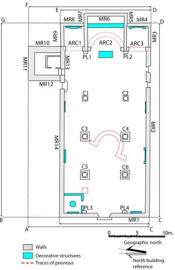
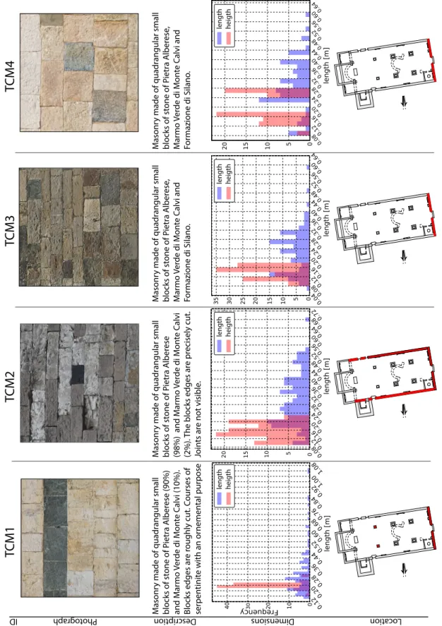
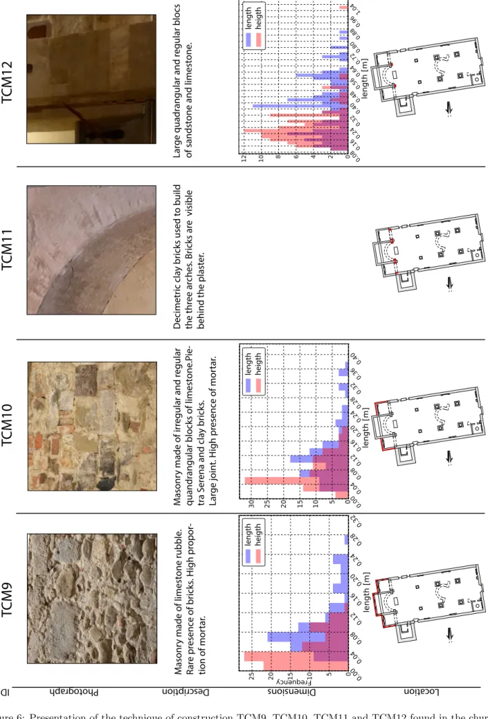
Description of the building techniques
16 building techniques are identified in the church and described in Figures 4-7. The used materials are mainly limestone (Pietra Albarese and Formazione di Silano), sandstone (Pietra Serena), serpentinite (Marmo di Monte Verdi) and bricks.
TCM1
TCM2
TCM3
TCM4
length heigth length heigth length heigth length heigth Loca tion Descr iption Dimensions ID ograph Phot M asonr y made of quadr angular small blocks of st one of P ietr a A lber ese (90%) and M ar mo V er de di M on te C alvi (10%). Blocks edges ar e r oughly cut . C ourses of ser pen tinit e with an or nemen tal pur pose M asonr y made of quadr angular small blocks of st one of P ietr a A lber ese (98%) and M ar mo V er de di M on te C alvi (2%). T he blocks edges ar e pr ecisely cut . Join ts ar e not visible . M asonr y made of quadr angular small blocks of st one of P ietr a A lber ese , M ar mo V er de di M on te C alvi and For mazione di Silano . M asonr y made of quadr angular small blocks of st one of P ietr a A lber ese , M ar mo V er de di M on te C alvi and For mazione di Silano .Loca tion Descr iption Dimensions ID ograph Phot length heigth length heigth
TCM5
TCM6
TCM7
TCM8
M asonry made of small quadr
angular ir regular blocks of P ietr a A lber ese (90%). T he blocks edges ar e r oughly cut . M asonr
y made of small quadr
angular
ir
regular blocks of sandst
ones . T he blocks edges r oughly cut . Join ts ar e not visible . M asonr
y made of small quadr
angular
regular blocks of limest
one
.
T
he blocks edges of the rubbles ar
e roughly cut . Join ts ar e not visible . Rubble masonr y with c or ner quoins in br icks . length heigth length heigth
TCM9
TCM10
TCM11
TCM12
M asonr y made of limest one rubble . R ar e pr esenc e of br icks . H igh pr opor-tion of mor tar . M asonr y made of ir regular and r egular quandrangular blocks of limest
one .P ie-tr a S er
ena and cla
y br icks . Lar ge join t. H igh pr esenc e of mor tar . D ecimetr ic cla y br icks used t o build the thr ee ar ches . Br icks ar e visible
behind the plast
er . Lar ge quadr angular and r egular blocs of sandst
one and limest
one . Loca tion Descr iption Dimensions ID ograph Phot length heigth length heigth length heigth
Loca tion Descr iption Dimensions ID ograph Phot
TCM13
TCM14
TCM15
TCM16
M asonr y made of ir reglar quadr angular blocks of P ietr a S erena. Bloc edges ar
e ir regular . Lar ge join t (>2cm). M asonr y made of ir regular quandr
angu-lar blocks of limest
one and ir regular limest one pebbles . P ietr a S er ena and For mazione di Silano . P resenc e of br icks . Lar ge join t (>2cm). M asonr y made of quandr agular ir
regu-lar blocks of limest
one and bet
w een one and t w o r o w s of br icks . Lar ge join t (>1cm). M asonr y made of ir regular quadr
angu-lar blocks and ir
regular pebbles of P ietr a S er ena and F or mazione di Silano . P resenc e of r ec o v er ed ma ter ial . Lar ge join t (>2cm). length heigth length heigth length heigth length heigth
5
Description of the constructive phases in the light of
historical sources
5.1
Phase 0
In 1963-1967 archaeological excavations inside the church have revealed the remains of an ancient mono apse church oriented NW-SE as shown in Figure17(Soprintendenza[1980]). The width of this first church is half of the current one. The use of paving stones of different colours indicate the previous location of the proto-church on the ground. Furthermore, the very first written evidence of the church dating from 984 A.D. has been found in Bullettone dell’Arcivescovado Fiorentino at page XI (Ajazzi [1887]) which probably corresponds to the current church. The phase 0 corresponding of the proto-church is estimated before 984 A.D..
5.2
Phase 1 and phase 2
There is no historical information about the evolution of the church between 984 and 1497. However, stratigraphic analysis shows significant repair operations during this period. Figure8 and Figure9 show both the external and internal west-facing wall of the church (MR1 in Figure17).
Phase 1 Phase 2 Phase 6 Phase 12 Phase 7 Phase 4 Phase 9 0 1 2 m. C A [1] [2] [3] [4] [34] [63] [64] [69] [70] [71] [72] [68] [67] [65] [66] [73] [29] [30] [28] [46] [3] [3]
Figure 8: Stratigraphy of the front wall (MR1, external west-facing of the church and MR12, external west-facing of the bell tower) showing phase 1, phase 2, phase 7, phase 8 and phase 13. Phase 1 corresponds to the original construction of the current Romanesque church. Phase 2 is identified as a repair of phase 1.
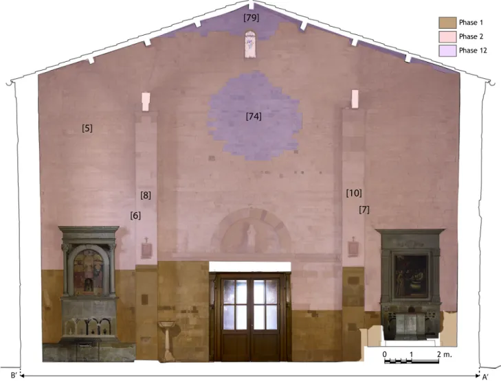
Phase 1 Phase 2 Phase 12 [6] [7] 0 1 2 m. B’ A’ [74] [8] [5] [10] [79]
Figure 9: Stratigraphy of the facade (MR1, internal west-facing of the church) showing phase 1, phase 2 and phase 13. Phase 1 corresponds to the original construction of the Romanesque church. Phase 2 is identified as a repair of phase 1.
At the bottom, we distinguish a clear and irregular limit between two building techniques : TCM1 and TCM2. Differences between both techniques are described in Figure 4. One of them is the use of a serpentinite course in the first phase. TCM2 is the most present technique in the current nave of the church (MR1, MR2, MR14, C3, C4, C5, C6, PL1, PL2, located in Figure17) as it is shown in Figure8,
0 2.5 5 m. P hase 3 P hase 4 P hase 7 P hase 8 P hase 12 P hase 2 P hase 1 P hase 13 A E
[16]
[15]
[18]
[47]
[31]
[32]
[49]
[50]
[48]
[77]
[3]
[52]
[75]
Figure 10: Stratigraphy of the external north-facing of the church (MR14) including the nave (on the rigth), the bell tower (on the middle) and the north lateral chapel. Phase 1, phase 2, phase 3, phase 4, phase 7, phase 8, phase 12, and phase 13 are identified.
P hase 8 P hase 2 P hase 13 E’ A’ 0 2.5 5 m.
[33]
[13]
[9]
[51]
Figure 11: Stratigraphy of the internal north-facing of the church (MR14) including the nave (on the rigth), the bell tower (on the middle) and the north lateral chapel. Phase 2, phase 4, phase 7, phase 8, and phase 13 are identified.
0 2.5 5 m. P hase 1 P hase 2 P hase 12 P hase 4 P hase 5 P hase 7 P hase 8 P hase 9 P hase 13 C D
[3]
[54]
[55]
[56]
[57]
[61]
[60]
[59]
[58]
[45]
[62]
[22]
Figure 12: Stratigraphy of the external south-facing of the church (MR2) including the nave (on the left), the bell tower (on the middle) and the south lateral chapel. Phase 2, phase 4, phase 5, phase 7, phase 8, phase 9, phase 12, and phase 13 are identified.
P hase 1 P hase 2 P hase 13 0 2.5 5 m. D’ C’
[11]
[12]
[54]
[76]
In the external part, the wall as well as the corners quoins using technique TCM1 are repaired using technique TCM2 (Figure 8). We note the particular case of the south wall corner. The wall corner of phase 1 is repaired using a block of sandstone (in pink in Figure8) belonging to phase 2. This quoin is nowadays isolated because of a third repair identified as phase 13 described below (phase 13 is associated with a second repair of the corner quoins). In the internal facing (MR1), such a limit is visible on the wall as well as on both pilasters PL3 and PL4 (Figure 9). The use of the technique TCM2 indicates the limit between the first and second constructive phase. Although the limit between phase 1 and phase 2 is mainly reported on the front wall, it is also observed in the external north facing wall of the nave (MR14 shown in Figure10) at the bottom right. Phase 1 is not visible on the north wall inside the church (Figure 11) not only because the ground is higher but also because this part of the wall has not been repaired. This is an indication of the typology of masonry using the ”sacco” technique (this technique corresponds to the filling between two wall claddings). Inside the churh, we note that both columns C1 and C2 use TCM1 in the lower part and TCM2 in the upper part. Reminding that the technique of construction TCM2 is dated from the 13th century (Arrighetti [2017]), we date the second phase of the building between 984 and the 13th century. In the absence of historical data, it is difficult to determine an origin to such a deep reconstruction of the church (anthropogenic origin, fire, natural disaster, ...).
5.3
Phase 3
D F E Phase 3 Phase 4 Phase 5 Phase 7 Phase 8 Phase 10 0 2.5 5 m. [12] [27] [26] [44] [16] [15] [14] [17] [20] [19] [23] [21] [43]Figure 14: Stratigraphy of the external east-facing of the church (MR4, MR6, MR8) including the bell tower (on the rigth), the central apse and both lateral chapels. Phase 3, phase 4, phase 5, phase 7, phase 8, and phase 10 are identified.
Phase 3 is related to the construction of the central apse (MR5, MR6, MR7) and the two lateral chapels (MR3, MR4 and MR8, MR9) using technique TCM9 for their fundations visible at the bottom of each wall and technique TCM16 for the walls. The stratigraphic analysis reveals the use of TCM16 in the edges of MR8 and MR9 of the northern chapel (Figures 10, 14 and 17) which implies that the central apse and the lateral chapels belong to the same building phase. However they are not necessary built at the same moment. Indeed, Lia Brunori Cianti mentioned the construction of both lateral rectangular chapels during the second half on the 15th century (p. 49, Brunori Cianti[2011]).
The delayed construction of both chapels is confirmed by the analysis of the church plan. In Figure
15, we firstly note the angular misalignment of 1.8◦between the wall MR9 of the northern chapel and the wall MR13 of the nave (represented in red line and collinear to the central apse walls MR5 and MR7).
0 5 10m. MR1 MR2 C1 C2 C3 C4 C5 C6 MR3 MR4 MR11 MR6 MR8 MR9 MR10 MR12 MR14 PL1 PL2 PL3 PL4 MR5 MR7 MR13 Geographic north North of the building
MR6
MR8
MR9
MR10
PL1
MR7
MR13
1.8°
Figure 15: Zoom in the northeast lateral apse. A misalignement is observed between MR9 and MR13.
The thickness of both walls at the bottom is different as shown in Figure16 (77 cm for MR13 and 61 cm for MR9).
0 5 10m. MR1 MR2 MR14 0.42 0.52 0.62 0.72 0.82 0.92 1.12 Thickness(m) 1.02 C2 C1 C4 C3 C5 C6 PL3 PL4 Geographic north North building reference MR4 MR11 MR6 MR9 MR10 MR12 MR5 MR7 MR13 MR8 MR3 PL2 PL1
Figure 16: Thickness of the church walls going from 0.42 m to 1.12 m. Such a difference characterizes the building evolution of the church over time.
5.4
Phase 4
Phase 3 Phase 7 Undetermined
Figure 17: The north lateral chapel. The first phase of the building is colored in red. The green part corresponds to a repair of the first phase.
Phase 4 corresponds to the original construction of the bell tower using technique TCM13 (presented in Figure7). The bell tower was built against the wall of the nave (MR14) as well as the wall of the northern lateral chapel (MR9, Figure8). Although there are no historical writings describing the con-struction of the bell tower, there are three argu-ments to date its delayed construction. Firstly, the technique which is used in MR10, MR11 and MR12 (technique TCM13 as shown in Figure 8) is fully different from the technique used in wall MR14 (TCM2) and from the technique used in the first stage of the northern lateral chapel (TCM16 used in the original phase of MR8 and MR9) (Fig-ure 17). This first observation indicates that the bell tower and the north lateral chapel, each result-ing from a separate construction site, were not built at the same time. Second, the spatial relationships between walls MR10 – MR9, MR10-MR13, MR12-MR13 and MR12-MR14 show the posteriority of the bell tower. Both MR 10 and MR 12 clearly lean against MR9; MR13 and MR 14 are not linked.
Finally, the walls of the bell tower are clearly wider than the ones of the nave as well as those of the lateral chapels as shown in Figure 16.
5.5
Phase 5 and 6
R. Ajazzi (Ajazzi [1887], p. 15) mentioned two
minor renovations of the church. The opening of a door in the east-facing wall of the bell tower in 1497 is retrieved by stratigraphic analysis (Figure 14). The repair of the three windows of the southern wall is also identified (in yellow in Figure 12). R. AjazziAjazzi[1887] mentions the repair of the rose window of the church in 1528 (Ajazzi [1887]). The traces of the old rose window is still visible on both sides of the west wall (MR1) confirming its existence since at least 1542 (Figure8 and Figure 9). It is nowadays infilled with technique TCM3 (Figure 4).
5.6
Phase 7 : repairs link to the 1542 seismic event
One of the largest earthquake in the Mugello basin occurred in June 6, 1542 (Guidoboni et al. [2018], Guidoboni et al.[2019]) with an estimated epicentral macroseismic intensity of 9 and an estimated mag-nitude of 6,02. The seismic event is reported at least in 81 historical records, among which 27 are from direct sources (Guidoboni et al.[2018], Guidoboni et al.[2019]). The epicenter is estimated very close to Scarperia (Figure2). In the particular case of Sant’Agata del Mugello, damage are reported in four main historical writings. Descriptions are different from one historical source to another. The first document is a letter dated from June 23, 1542 and kept in the Biblioteca Nazionale Marciana di Venezia (*[d], primary source). It reported damage related to the earthquake such as collapsed buildings, injuries and fires in the whole basin. The village of Sant’Agata composed of around 100 houses is described as being entirely collapsed with 11 fatalities. The church seems to be entirely destroyed except a part of the bell-tower described with a bell still attached at the top of the tower.
”Santa Agata quale era honorevel vila de pi`u di cento fuochi e li erano molte bellissime case sta peggio del altre, tutta si trova rovinata e cos`ı un bel tempio che li era e il campanile tutto sfassciato, sopra del quale li `e rimasto la campana quale sta in bilico ne si vede come n´e chi la sustenti talch´e pare cosa stupenda e meravigliosa e l`ı sono morti XI.”
A second document originates from the archivio di stato di Firenze (* [a], primary source) provided detailed information about the effect of the earthquake in the Mugello basin (1742 collapsed buildings and 113 dead people). The particular case of Sant’Agata is described as a collapsed church with 6 injuries:
”S[an]ta Agata Villa rovinata la chiesa, e mortovi 6 persone.”
A third document from the archivio di stato di Pistoia (* [b], primary source) gives some quantitative information about the effect of the earthquake (more than 1500 collapsed building). The description of the building damage in Sant’Agata is particularly focused on the church described as entirely destroyed.
”Sancta Agata tutta la chiesa e la casa rovinata; morti 6.”
Finally a document from the Archivio Parrocchiale dei Santi Jacopo e Antonio di Fivizzano (*[c], primary source). described the church as being destroyed with 6 dead people.
”Castelgrosso e Santagheta ruvinata la chiesa e morto persone 6.”
The archives clearly demonstrate the occurrence of a seismic event as an hypothesis to explain the observed repairs described below. Throughout the rest of this section, repairs related to the 1542 seismic event are described considering each macroelement of the church (the front wall, the bell tower, and the lateral chapels). As introduced in section3.1.1, Nozzolini’s log book provides some information about the effect of the 1542 earthquake on the church. Even if T. Nozzolini did not witness the 1542 seismic event, he collected first hand information. He described the bending of the front wall as a result of the 1542 seismic event. The stratigraphic analysis reveals that wall corners of the front wall have been restored (represented in green in Figure 8 as blocks which did not staggered). In the case of the bell tower, Nozzolini learned from senior people who witnessed the 1542 seismic event that the bell tower was higher before the 1542 earthquake (Figure 18, [Brunori Cianti, 2011]). They decided after the earthquake to rebuild only the south wall of the bell tower where they opened two windows. The rest of the bell tower was then covered with a roof. Nozzolini found the bell tower in this state when he represented it in his log book (Figure 18). The stratrigraphic analysis confirms the construction of the top of the south facing wall of the bell tower as shown in green in Figure 8,12 and 14. The original shape of the south facing wall of the bell tower as it was rebuilt after the 1542 earthquake is visible in Figure 12. The infilling of the cracks is still visible on the west facing wall of the bell tower (MR12 in Figure 8).
In the case of the two lateral chapels, there is no documentation regarding the 1542 seismic event. A discordance is yet observed between technique TCM10 and technique TCM16 (Figure 10 and 14). In Figure 17, TCM10 is clearly used after TCM16. Such a discordance is interpreted as a repair of the technique TCM16 using technique TCM10. The stratigraphic analysis clearly show that damage description from historical sources should be carefully taken into account. The full collapse of the church described in the texts is not compatible since we still observe the aforementioned phases (phase 1 to phase 6) identified in the nave (Figures 8-13), the lower part of the bell tower (Figure 8) as well as the apse (Figure 14). From historical texts, we only validate the partial destruction of the bell tower (since the lower part which is older is still visible).
5.7
phase 8 : first phase of repairs carried out by T. Nozzolini
Phase 9 is related to the Nozzolini’s repairs from 1608. The priest funded and lead unfinished restoration work on the church after the 1542 earthquake. He described the front wall as tilted. He first put the porch into its original position since the beams and the roof of the porch went outside of 30 cm (Brunori Cianti [2011], p. 82).
”Ad`ı 12 di Agosto per haver rimesso al suo luogo il tetto del portico dinanzi alla chiesa che l’anno 1542 era uscito per il terremoto e calato le travi dal luogo suo in fuori un mezzo braccio [...]”
He used a tie rod to fix one of the beam of the porch to the front wall of the church. Two smaller tie rods are also fixed at the same place. Such reinforcement are no more visible.
”Per una catena di ferro di libbre 9 che lega una delle travi di detto tetto con la facciata della chiesa per un paletto di ferro di libbre 7 che tene detta catena di dentro nella chiesa 1. due tutto Per due altre catenuzze minori poste al medesimo etto di libbre 5.”
Nozzolini describes the restoration of the roof of the church, as well as the porch of the bell tower. Even if the stratigraphic analysis detects the evidence of a previous porch along the north wall of the church (in blue in Figure10) and the west wall of the bell tower (in blue in Figure8), it does not correspond to the porch described by Nozzolini. We believe the so called porch was located against the east wall of the bell tower since a door existed at that time The priest also did some repairs in the dovecote (under the roof of the bell tower) (p. 87, Brunori Cianti[2011]) and he leveled also the ground of the church as it is nowadays observed (Brunori Cianti[2011], p 82) :
”Per dua migliaia di mezzane per mattonare la chiesa dal mezzo in sula quale feci abbassare `e ridurre tutta a un piano scudi dieci e lire quattro per farle arrotare prima che si cocessero” ”A abbassare il pavimento e fare il fondamento.”
Nozzolini indeed describes the presence of several items that are no more in the church. In particular the existence of a stair going from the church to the dovecote (located in the bell tower at that time). He filled the door in the bell tower which is still visible (in blue in Figure 11).
”In questo medesimo Campanile l’anno 1607 feci la scala murata che `e in sacrestia, che prima si montava di chiesa con una scala grande di legno, che arrivava a quell’uscio che hora apparisce murato nella prima colombaia.”
5.8
Phase 9 : the seismic event of 1611
A new seismic event occurred in September 8, 1611 with an estimated epicentral intensity of 7. The epicenter is located very close to Scarperia (Figure 2). This event is poorly described in the historical sources. Nozzolini described the event as a terrible disaster ([Brunori Cianti,2011], p 88):
”[...] a d`ı 8 di settembre detto anno a hore quattro e mezzo di notte venne un terremoto terribilissimo che rovino infite muraglie par il mugello ...”.
In the church, three chimneys collapsed, the cracks caused by the 1542 seismic event reopened and new cracks are detected. Such damage are visible in Figure 8. Because the belltower is particularly damaged, Nozzolini proposed a deep restoration of the building as described in its notebook (Brunori Cianti [2011], p 89).
”[...] io Tolomeo Nozzolini l’anno 1612 da d`ı 9 di luglio fino a tutto agosto mi misi a rassettarlo, la facciata delle Campane, non la toccai di niente se non quanto che essendo aguzza, l’alzai dalle bande e un braccio pi`u, e la ridussi a facciata piana, dell’altre tre facciate ne disfeci otto braccia che erano intenebrate e conquassate e le alzai al pari di quell’altra e feci il campanile quadro con quelli altri tre finestroni e lo ridussi a padiglione nel modo che horasi trova, la spesa che vi `e adata `e quella che qui di sotto segue.”
The three walls of the bell tower (north wall, west wall and east wall) are leveled off about 4.7 m and then rebuilt at the same height as it is visible today (in blue in Figures 8,10 and 14). The raising of the roof of the south facing wall of the bell tower (going from a triangular facade to a rectangular one) is visible in green in Figure 12.
5.9
Phase 10, phase 11 and phase 12
According to R. Ajazzi Ajazzi[1887] the east door of the bell tower is embedded in 1659. This repair is still visible in Figure14 (in purple) and corresponds to phase 10.
Phase 1 Phase 2 Phase 3 Phase 11 E’ D’ 0 2.5 5 m. [40] [24] [41] [42]
Figure 19: Stratigraphy of the inner east-facing of the church (MR4, MR6, MR8) showing phase 1, phase 2, phase 3 and phase 11. Phase 1 corresponds to the original construction of the Romanesque church. Phase 2 is identified as a repair of phase 1.
In 1819, some restoration works are done in the church choir corresponding to phase 11. The arc of the central apse (ARC2) is raised about 1.20 m (Brunori Cianti[2011]). This operation induced a partial destruction of the upper part of the choir. This restoration work is visible in pink in Figure 19. The two lateral apses are lengthened about 1.8 m (Brunori Cianti [2011]) but this work is no more visible because of the plaster on the walls.
”allungare le due ali del Mur delle Cappelle laterali per la lunghezza di braccia tre ciascuna , come pure il Muro che recinge il detto Coro perla lunghezza di Braccia 111/4.”
Phase 12 is related to some reconfiguration work like the filling of the rose window and the repair of the front wall corners.
(a) View of the church of Sant’Agata in 1802. (b) Photo of the church in 1905.
Figure 20: a) View of the church of Sant’Agata in 1802 (Fontani[1802]). b) Photograph of the church in 1905
(personal communication).
The rose window of the church is no more present as shown in Figure 20b contrary to the view shown in Figure 20a. Finally, we note the disappearance of the porch between the picture and the photo.
5.10
The 1919 seismic event
A new seismic event occurred in June 29, 1919 with an estimated epicentral macroseismic intensity of 7 in Sant’Agata and an estimated macroseismic magnitude of 6,38. The epicenter is located in the south-eastern part of the Mugello basin, 30 km away from Sant’Agata (Figure2). Four primary sources describe the church in Sant’Agata (Guidoboni et al. [2019], Guidoboni et al. [2018]). Some minor damage are reported in the church like small cracks as well as the movement of some decorative structures inside the church. The stratigraphic analysis does not reveal any repairs associated with this historical earthquake.
5.11
The phase 13
This final phase is related to all the restoration events during the 19th century. All the phases are summarized in Figure 23.
5.12
Building techniques for repairs
Figure21shows the distribution of both the building techniques used in the repair units (Figure21), and the building techniques which are repaired themselves (Figure21b). The most commonly used techniques in repairs are TCM2 (41 %) and TCM8 (15.4 %). The most repaired techniques is also TCM2 (50.7 %). It is interesting to note that the building technique TCM2 is mostly repaired by TCM2 itself at different
period of time (mainly for the openings infilling). It shows that ancient builders had the will to make discreet repairs avoiding, for example, to repair blocks of limestone (TCM2) with bricks (TCM8) .
a b
Figure 21: a) Distribution of the building techniques used in the repairs. b) Distribution of building techniques which are repaired.
6
Geometry and material evolution of the church
We summarize our findings by building a time line of the phases chronology in the light of historical records and stratigraphic analysis (Figure 22 and 23), proposing sketches for the 13 building phases identified (Figure24) as well as for the earthquake damage mechanisms identified (Figure25). The time line (Figure22) clearly outlines the complementarity contribution of historical records and stratigraphic analysis in the different construction phases identified.
Date Origine Seismic itensity Phases
Source Type of operation
Construction Seismic event Io Epicentral macroseismic Is Intensity in Sant’Agata Archaeological data Historical source Undetermined destruction Repairs intensity 5 7 8 11 12 13 6 4 3 2 1 0 9 10 <984 A.D. 948 1175 12th - 13th 1497 1500 1512-1513 1525-1526 1528 1536 1544 1546 1548 1611-1630 1659 1748 1802 1542 1597 1727 1762/04/15 1833-1834 1835 1843 1875 1905 1963-1967 1980 2008 1864 1919 1912 1929 1931 1939 1960 1969 1553 15th 1611 1914 1608-1611 1819 15th Io = 9, Is = 9 Io = 7-8, Is = ? Io = 7, Is = ? Io = 6-7, Is = ? Io = 7, Is = ? Io = 6, Is = ? Io = 6-7, Is = ? Io = 7, Is = ? Io = 5, Is = ? Io = 10, Is = ? Io = 6-7, Is = ? Io = 6, Is = ? Io = 7, Is = ? Io = 7, Is = ? Io = 4-5, Is = ?
Figure 22: Relative chronology of the construction of the Sant’Agata church crosschecking historical sources and stratigraphic analysis. The figure shows on the left the origin of the data used to identify the construction phases (historical records or stratigraphic analysis).
The assembly of the different aforementioned phases is summurized in Figure 23. Phase 1 Phase 2 Phase 6 Phase 11 Phase 7 Phase 4 Phase 9 Phase 3 Phase 5 Phase 8 Phase 10 Phase 12 Decorative structures 0 5 10m. Geographic north North building reference
Figure 23: Architectural evolution of the church over time summurizing the assembly of the different aforementioned phases.
Based on this time line and on the architectural evolution of the church (Figure23), an interpretation of the evolution of the church’s architecture highligthing both the geometry and the material evolution over time is proposed (Figure24).
a b c d e f i h g j k l
Phase 2 : < 12-13th century Phase 3a : 15th century Phase 3b : 15th century
Phase 4 : 15th century Phase 5 : 1497 Phase 6 : 1525-1526
Phase 7 : 1542-1608 Phase 8 : 1608-1611 Phase 9 : 1611-1630
Phase 10 : 1659 Phase 11 : 1819 Phase 12 : 1835 - 1905
North reference building Geographic north Phase 1 Phase 2 Phase 3 Phase 4 Phase 5 Phase 6 Phase 7 Phase 8 Phase 9 Phase 10 Phase 11 Phase 12
Figure 24: Sketches of the 12 building phases of the church over time.
During phase 0, the current church did not exist. The trace has been drawn on the floor of the current church using color stones (Figure 23). Phase 1 is related to the construction of the first phase of the current church (Figure24a). This phase is still visibile at the bottom of the church (Figure 23). Building technique TCM1 is used. The shape of the nave of phase 1 is not precisely known. However another trace of a monocircular nave is still visible in the central apse of the current church (Figure 23). Figure 24a provides an interpretation of the church as it could have been. The hypothesis of a semi-circular apse is also mentioned by Lia Brunori Cianti (Brunori Cianti[2011]). Phase 3 is characterized by the construction
of a rectangular central apse as well as the two lateral chapels. However, it is difficult to know if their construction was carried out at the same time. On the basis of three arguments, it was decided to split phase 3 in two subphases : phase 3a corresponding to the construction of the central apse (Figure 24b) and phase 3b related to the addition of the side chapels (Figure 24c). First, the thickness of the walls of the central apse and the lateral chapel is different (Figure 16). Second, an angular deviation of 1.8 degree has been detected between MR9 and MR13 (Figure15). Initially, the central apse had to be built and connected to the wall of the older nave (Figure24b). In a second step, the side chapels were added. The angular deviation of the north chapel is then interpreted as a design error. The rectangular central apse is built during phase 3a while the two lateral chapels are added during phase 3b. According to a stratigraphic argument : MR8 is built after MR7 (Figures 10, 14 and 17). The third historic argument comes from the analysis of Lia Brunori Cianti (Brunori Cianti [2011], secondary source) describing the addition of the two lateral chapels over the 15th century. Phase 4 corresponds to the construction of the bell tower against the north wall of the church (Figure 24d). The original height of the bell tower is discussed below. During phase 5, both the stratigraphic analysis and historical records confirms the opening of a door in the east wall of the bell tower (Figure24e). Phase 6 corresponds to the construction of a penthouse along the front wall (Fig. 24f). This structure element is commonly cited in the historical records over time.
a b Phase 1 Phase 2 Phase 3 Phase 4 Phase 5 Phase 6 Phase 7 Phase 8 Phase 9 Phase 10 Phase 11 Phase 12
Figure 25: Sketches of the damage mechanisms identified for both, the 1542 (a) and 1611 (b) seismic event.
Phase 7 is related to the repairs after the 1542 seismic event (Figure24g). The impact of the historical earthquake is described at the scale of the entire basin but not at the building scale. The church is thus described as entirely destroyed in the records. However stratigraphic analysis, providing an accurate location of building damage and repairs, proves that the nave and the bell tower were still standing. Such a result suggests how emphatic historical sources could be, in the description of the effects of an earthquake. This tendency is all the more common in written testimonies which record a reconstruction work, enhancing the role of an individual or institutional initiative ([Thomas and Witschel, 1992], and thus should not be taken literally (Guidoboni et al.[2009]).
Archives as well as stratigraphic data show that the top of the bell tower probably collapsed. The north, east and west facing wall of the bell tower were directly covered with a roof (15,5 m high deduced by the botom limit of OPUR 44, 45 and 46 which also preserved such a limit from other construction phases) while the south wall is raised up above the roof (19,7 m high deduced from opur 44, 45 and 46). The dimensions of the church after such repairs are deduced from Nozzolini’s description since he leveled it off 4,7 m. The nave currently has titling walls. Even if the induced damage of the front wall were repaired again when Nozzolini arrived 66 years after the 1542 earthquake, the repairs of the corner quoins are still visible (in green in Figure 24). It induced a bending of the three walls of the nave (Figure25a). Such a bending is still visible since the corner walls are vertical while the middle part of the nave is bending. An important repair of the two lateral chapel is detected only by stratigraphic analysis. The failure mechanism deduced from such repair is a collapse of both chapels (Figure25a on the right). It is important to note
that the absence of historical documents would have made it impossible to identify such damage without a stratigrapic analysis. Phase 8 corresponds to the first repair work led by T. Nozzolini between 1608 and 1611 (Figure 24h) and is precisely described in his exceptional log book. The north penthouse is rebuilt and a new one is built along the south wall of the nave. Phase 9 is related with the repairs made by T. Nozzolini after the 1611 seismic event (Figure 24i). His log book as well as the stratigraphic analysis of the bell tower show a reconfiguration of the top of the building. The damaged walls were first reduced then raised up until the current configuration. The identified repairs as well as the historical description suggests a deep cracking of the bell tower (as shown in Figure 25b). The eastern door of the belltower is embedded during phase 10 (Figure 24j) as described by historical writings and corroborated by the stratigraphic analysis. In 1819, the central apse is raised up related to phase 11 (Figure 24k). Phase 12 corresponds to the infilling of the rose window and the repair of the front wall corner (Figure 24l). Modern restoration over the 20th century are done during phase 13. The dimensions of most structural elements over time are fairly well known (nave, side chapels, central apse). In the case of the height of the original bell tower (built during phase 4) we have no direct information since it was destroyed and rebuilt many times. However Figure 26 described how we constrained the original height (h4) from the identified successive repair units and the historical sources. Figure26focused on the west wall of the bell tower. The oldest limit is h2 (estimated at 15.35 m from orthophoto in Figure 8) corresponding to the height of the damaged bell tower just after the 1542 earthquake and on which people decided to rebuild the south wall of the bell tower. After the first repair of the bell tower (phase 7, OPUR 46) the maximal height (h5) of the south wall of bell tower is of 18.58m (deduced from stratigrapic analysis in Figure 8). Since only the south wall of the church has been rebuilt, we can give a first evaluation of the height of the belltower between h2 and h5 (i.e. between 15.35m and 18.58 m). Furthermore, this evaluation can be impoved using additional information from Nozzolini’s notebook. Indeed the only Nozzolini’s work in the bell tower is the destruction of 4,7 m of the three walls until the still visible h1 limits. h3 is then deduced from h1 at 17,38 m which is inevitably lower than the original heigth h4. It is important to note that h2 and h3 are not necessary equal since a slight levelling probably had to be done in order to be able to build the south wall contrary to the three other walls of the bell tower. The original height h4 can thus be constrained between h3 and h5 (i.e. 17.38 m and 18.58 m).
h3 = 17,38 m
h1 = 12,68 m
h2 = 15,35 m
h5 = 18,58 m
h6 = 20,68 m
h4 = ?
Phase 4
Phase 7
Phase 9
<1542
1542 - 1608
1611
[46]
[46]
[28]
Figure 26: Scheme of the west wall of the bell tower to discuss the evolution of its height over time. OPUR ID are specified in square brackets.
7
Conclusion
Combining the analysis of historical records with the analysis of building stratigraphy following the RECAP method, we propose here a new approach to trace the architectural evolution of the Sant’Agata del Mugello church and identify damage mechanisms. 80 repair units are inventoried in the OPUR database. The identified repairs are then compared with written records which constitute an exceptional evidence. Such a methodology allows to identify 13 building phases. The two methods provide complementary information. Sometimes, information is not detected from one of the two methods. As an example, the collapse of both lateral chapels of the church during the 1542 earthquake was detected only from stratigraphic analysis since the seismic event is very little described in historical sources. Archives made it possible to distinguish between postseismic repairs and common reconstruction of the building. Both methods allow to identify and quantify damage mechanisms. Phase 7 and phase 9 are related with earthquake damage. As expected, the 1542 seismic event was the most damaging earthquake. Cracks damaged the bell tower inducing the fall of the top of the bell tower. The three walls of the nave are damaged following a bending damage mechanism. A complex overturning characterized the collapse of the two lateral chapels. T. Nozzoloni delivered an exeptional log book describing the multiple renovation works as well as repair works. The document contains first hand information about damage related to the 1542 seismic event. No damage are related to the 1597 earthquake. Before the 1611 seismic event, the front wall of the church was replaced in its original position. A penthouse was built alongside the southern facing wall of the nave. The 1611 seismic event damaged only the bell tower inducing deep cracks through the walls. The tower was first lowered then raised up to its current height. The study shows a drastic change in the building techniques used in the church over time. The earliest building techniques used large blocks of limestone for the building of the church : the nave, the central apse, the early stage of lateral chapels and the one of the bell tower. Techniques using large blocks of limestone are also used in the repair units. As an example, TCM2 is used to repair the nave. Nevertheless, damage induced by the 1542 seismic event are so important that building techniques drastically evolved. Masonry techniques with rounded shaped blocks or pebbles are used. Mortar is dominant (TCM9 and TCM10). TCM9 and TCM10 have a high vulnerability since material can be caught by hand. Techniques using stones and bricks are also used. The decreasing quality of the building techniques could be related to a quick reconstruction of the damaged church with limited fundings. The Nozzolini period (phase 8 and 9 from 1608 to 1630) is characterised by an improvement in the building techniques used to rebuild both the 1542 and 1611 seismic damage. Nozzolini’s renovation used very small rectangular blocks of limestone with bricks using a more resistant mortar (TCM14). No more repairs are related with earthquakes after phase 9. Rectangular blocks of limestone are used to infill the rose window in the front wall and decimetric block of limestone are used in the wall corners with concrete. If the archives corroborates the stratigraphic analysis, the latter allows to improve the text interpretation. As an example, the analysis clearly shows that the church did not entirely collapsed after the 1542 earthquake as it was written. This comparison is essential even in the case of detailed historical sources like the Nozzolini’s notebook. Accounts of post-seismic reconstructions are indeed often the elaboration of an individual memory through the glorification of renovation works (B´erenger-Badel[2005],Thomas and Witschel[1992]). Such a precision is particularly important to enhance the definition of epicentral macroseismic intensities.
The church of Sant’Agata is an exceptional working laboratory since the repair operations are still visible and the existence of exceptional historical documents like Nozzolini’s log book allows to corroborate the information obtained from stratigraphic analysis. Such an extraordinary richness of information is mainly due to the Sant’Agata population who is strongly engaged into the preservation of its heritage. Indeed, the town hall of Scarperia e San Piero sponsored an outreach event, held in October 2019 in the church of Sant’Agata, to present the project to the local population and to hare with them the main results of this study.
To conclude, this cross-disciplinary protocol, developed in the framework of a case study, has the potential to be applied to other buildings of different typologies, periods or locations and to contribute more broadly to the knowledge of the local historical seismicity.
Acknowledgment
The authors thank the two anonymous reviewers and the editor Chris O Hunt for their enthusiastic reception of the paper and their helpful comments which improved the initial manuscript. The work greatly benefited from various supports: Cecilia Ciuccarelli who helped in finding the historical sources; Emma Cantisani and Fabio Fratini who shared results on their ongoing research on mortar analysis; Giovanni Minutoli, Tommaso Francucci, Marco Repole and Pierpaolo Lagani for sharing the cloud points from 3D laser scanner acquisition; the students of the restoration course (2018–2019) from Universit´a degli Studi di Firenze participated in the photogrammetry acquisition and in the field data acquisitions; Raffaella Leporini provided fruitful comments on archaeological analysis; the students of the Archaeology of Buildings course of the University of Siena (2018–19), coordinated by Andrea Arrighetti and Giovanna Bianchi, provided support in archaeological analysis. We also thank Agn`es Tricoche (LabEx TransferS) for her col- laboration on the OPUR database. The authors warmly thank the community of Sant’Agata del Mugello for their moral and logistic support, in particular, the major Federico Ignesti, Don Gianluca Mozzi, Marco Casati, Filippo Bellandi, Paolo Gucci and Anna Bambi. This work was funded by IRSN and program TelluS-ALEAS of INSU-CNRS.
References
*. *, archivio di stato di firenze, carte strozziane, serie i, 353, cc.104-105, nota d’un tremoto venuto nel mugello sotto d`ı 12 di giugno lo anno 1542, e le rovine da quello fatte. xvi sec. a.
*. Archivio di stato di pistoia, corporazioni religiose (patrimonio ecclesiastico), vol.270 f, cc.98-99, reso-conto del padre s.vongeschi di cutigliano sul terremoto del mugello del 13 giugno 1542, giugno 1542. 1542. June b.
*. Archivio di stato di pistoia, corporazioni religiose (patrimonio ecclesiastico), vol.270 f, cc.98-99, reso-conto del padre s.vongeschi di cutigliano sul terremoto del mugello del 13 giugno 1542, giugno 1542. 1542. c.
*. Una lettera de la discriptione del terremotto che `e stato in toscana, la qual narra particolarmente tutte le terre che son ruinate e le persone morte, e li fuochi apparsi in aere, e la terra ap[er]ta, e de un lago fatto di acqua spuzolente di solfere, la quantit`a, e il numero delle case ruinate le qualcose furno a d`ı iii luio mdxxxxii. venezia 1542. June d.
R. Ajazzi. Addizioni di ricordi storici di Sant’Agata di Mugello. Firenze, 1887.
P. Albini, A. Rovida, O. Scotti, and H. Lyon-Caen. Large eighteenth–nineteenth century earthquakes in western gulf of corinth with reappraised size and location. Bulletin of the Seismological Society of
America, July 2017. doi: 10.1785/0120160181. URL https://doi.org/10.1785/0120160181.
Alessio Marchetti, Fabio Redi, Francesca Savini, and Ilaria Trizio. The Archaeoseismology of Historical Buildings: A Model Study from the L’Aquila Area in Italy. Journal of Civil Engineering and
Archi-tecture, 11(10), Oct. 2017. ISSN 19347359, 19347367. doi: 10.17265/1934-7359/2017.10.008. URL
http://www.davidpublisher.org/index.php/Home/Article/index?id=34569.html.
A. Amato, A. Antonioli, L. Chiaraluce, P. D. Gori, R. D. Stefano, F. Doumaz, L. Faenza, V. Lauciani, A. Marchetti, F. Mele, A. Michelini, M. Pirro, L. Scognamiglio, G. Selvaggi, L. Valoroso, S. Vinci, M. Anselmi, V. D. Rubeis, D. Piccinini, P. Sbarra, E. Tinti, P. Tosi, and A. Fiaschi. Rapporto tecnico-scientifico sulla sequenza sismica del mugello del 1 marzo 2008. Instituto Nazionale di Geofisica e
Vulcanologia, page 30 pp, 2008.
N. N. Ambraseys. Value of historical records of earthquakes. Nature, 232(5310):375, 1971. URLhttps: //doi.org/10.1038/232375a0.
A. Arrighetti. Constructive and seismic history of the sant’agata del mugello parish church. In P. I. LM, editor, reuso 2015. III congreso internacional sobre documentacion, conservacion y reutilizacion del
patrimonio arquitectonico y paisajistico, pages 64–70, Valencia - ESP, 2015 2015. Editorial Universitat
Polit`ecnica de Val`encia. ISBN 9788490483862. Contributo in Atti di convegno.
A. Arrighetti. Materiali e tecniche costruttive del Mugello tra basso Medioevo e prima Et`a Moderna.
Arqueolog´ıa de la Arquitectura, (13):037, Jan. 2017. ISSN 1989-5313, 1695-2731. doi: 10.3989/arq.arqt.
2016.001. URLhttp://arqarqt.revistas.csic.es/index.php/arqarqt/article/view/192. A. Arrighetti. Registering and documenting the stratification of disruptions and restorations in
histori-cal edifices. the contribution of archaeoseismology in architecture. Journal of Archaeologihistori-cal Science:
Reports, 23:243–251, Feb. 2019. doi: 10.1016/j.jasrep.2018.10.028. URL https://doi.org/10.1016/
j.jasrep.2018.10.028.
G. Bankoff. Design by disasters: Seismic architecture and cultural adaptation to earthquakes. In Cultures
and Disasters, pages 69–87. Routledge, 2015.
M. Benvenuti. Facies analysis and tectonic significance of lacustrine fan-deltaic successions in the pliocene–pleistocene mugello basin, central italy. Sedimentary Geology, 157(3-4):197–234, Apr. 2003. doi: 10.1016/s0037-0738(02)00234-8. URLhttps://doi.org/10.1016/s0037-0738(02)00234-8.
A. B´erenger-Badel. Les s´eismes dans la documentation ´epigraphique et numismatique sous le haut-empire: entre ´elaboration de la m´emoire et reconstruction de l’´ev´enement. R´ecits et repr´esentations
des catastrophes depuis l’Antiquit´e, pages 161–173, 2005.
L. Binda, G. Cardani, A. Saisi, and M. Valluzzi. Vulnerability analysis of the historical buildings in seismic area by a multilevel approach. 2006.
P. Boncio, F. Brozzetti, and G. Lavecchia. Architecture and seismotectonics of a regional low-angle normal fault zone in central italy. Tectonics, 19(6):1038–1055, Dec. 2000. doi: 10.1029/2000tc900023. URL
https://doi.org/10.1029/2000tc900023.
M. Bonini, G. Corti, D. D. Donne, F. Sani, L. Piccardi, G. Vannucci, R. Genco, L. Martelli, and M. Ripepe. Seismic sources and stress transfer interaction among axial normal faults and external thrust fronts in the northern apennines (italy): A working hypothesis based on the 1916–1920 time–space cluster of earthquakes. Tectonophysics, 680:67–89, June 2016. doi: 10.1016/j.tecto.2016.04.045. URLhttps: //doi.org/10.1016/j.tecto.2016.04.045.
M. Bradtm¨oller, S. Grimm, and J. Riel-Salvatore. Resilience theory in archaeological practice–an anno-tated review. Quaternary international, 446:3–16, 2017. URLhttps://doi.org/10.1016/j.quaint. 2016.10.002.
G. P. Brogiolo. L’archeologia dell’architettura in italia nell’ultimo quinquennio (1997-2001). Arqueolog´ıa
de la Arquitectura, (1):19–26, 2002.
L. Brunori Cianti. Sant’agata: una santa, una pieve, una comunit`a del mugello. 2011.
A. Cagnana and T. Mannoni. Archeologia dei Materiali dacostruzione. Mantova: SAP Editrice, 2000. H. Dessales. The villa of diomedes. the making of a roman villa in pompeii. Paris 2020, 2020.
H. Dessales and A. Tricoche. Un database per studiare le riparazioni post-sismiche.
Archeolo-gia dell’Architettura, XXIII, 2018–ArcheoloArcheolo-gia dell’architettura e terremoti, 23:19–24, 2018. URL
https://hal.archives-ouvertes.fr/hal-02291284.
DISS Working Group. Database of individual seismogenic sources (diss), version 3.2.1: A compilation of potential sources for earthquakes larger than m 5.5 in italy and surrounding areas, 2018. URL
http://diss.rm.ingv.it/diss/index.php/DISS321.
D. Donne. Tettonica attiva dell’appennino settentrionale nel settore compreso tra l’appennino pistoiese e l’alta val tiberina. universit`a degli studi di fi- renze (unpublished phd thesis, 144 pp). 2005. URL
https://doi.org/10.1785/0120160181.
F. Fontani. Viaggio pittorico della Toscana dell’Abate Francesco Fontani, volume 2. Firenze, 1802. P. Forlin and C. M. Gerrard. The archaeology of earthquakes: the application of adaptive cycles to
seismically-affected communities in late medieval europe. Quaternary international., 446:95–108, 2017. URLhttps://doi.org/10.1016/j.quaint.2017.06.030.
E. Guidoboni, J. E. Ebel, et al. Earthquakes and tsunamis in the past. a guide to techniques in historical seismology. 2009.
E. Guidoboni, G. Ferrari, D. Mariotti, A. Comastri, G. Tarabusi, G. Sgattoni, and G. Valensise. Cfti5med, catalogo dei forti terremoti in italia (461 a.c.-1997) e nell’area mediterranea (760 a.c.-1500), 2018. URL
http://storing.ingv.it/cfti/cfti5/.
E. Guidoboni, G. Ferrari, G. Tarabusi, G. Sgattoni, A. Comastri, D. Mariotti, C. Ciuccarelli, M. G. Bianchi, and G. Valensise. CFTI5med, the new release of the catalogue of strong earthquakes in italy and in the mediterranean area. Scientific Data, 6(1), June 2019. doi: 10.1038/s41597-019-0091-9. URL

![Figure 2: Seismotectonic context of the Mugello area (adapted from Bonini et al. [2016])](https://thumb-eu.123doks.com/thumbv2/123doknet/14712563.567952/5.918.102.827.247.886/figure-seismotectonic-context-mugello-area-adapted-bonini-et.webp)