HAL Id: tel-03003651
https://hal.archives-ouvertes.fr/tel-03003651
Submitted on 13 Nov 2020HAL is a multi-disciplinary open access
archive for the deposit and dissemination of
sci-L’archive ouverte pluridisciplinaire HAL, est destinée au dépôt et à la diffusion de documents
from heterogeneous visual data
Nathan Piasco
To cite this version:
Nathan Piasco. Vision-based localization with discriminative features from heterogeneous visual data. Engineering Sciences [physics]. Université Bourgogne Franche-Comté, 2019. English. �tel-03003651�
Vincent Lepetit, Professor, University of Bordeaux
Nicolas Thome, Professor, Conservatoire national des arts et métiers
Day of the defense: 25/11/2019
Peer-Review Journals Papers
1. N. Piasco, D. Sidibé, V. Gouet-Brunet and C. Demonceaux. Improving Image Description with Auxiliary Modality for Visual Localization in Challenging Conditions. (in submission)
2. N. Piasco, D. Sidibé, C. Demonceaux and V. Gouet-Brunet. A Survey on Visual-Based Localization: On the Benefit of Heterogeneous Data. Pattern Recognition, Volume 74, February 2018, pp.90-109.
Peer-Review International Conferences
1. N. Piasco, D. Sidibé, C. Demonceaux and V. Gouet-Brunet. Perspective-n-Learned-Point: Pose Estimation from Relative Depth. 2019 British Machine Vision Conference (BMVC), Cardiff, United Kingdom, September 2019.
2. N. Piasco, D. Sidibé, C. Demonceaux and V. Gouet-Brunet. Geometric Camera Pose Refinement with Learned Depth Maps. 2019 IEEE International Conference on Image Pro-cessing (ICIP), Taipei, Taiwan, September 2019.
3. N. Piasco, D. Sidibé, V. Gouet-Brunet and C. Demonceaux. Learning Scene Geometry for Visual Localization in Challenging Conditions. 2019 IEEE International Conference of Robotics and Automation (ICRA), Montreal, Canada, May 2019.
Peer-Review National Conferences
1. N. Piasco, D. Sidibé, V. Gouet-Brunet and C. Demonceaux. Apprentissage de modalités auxiliaires pour la localisation basée vision. Reconnaissance des Formes, Image, Apprentis-sage et Perception (RFIAP), Champs-sur-Marne, France, June 2018
2. N. Piasco, D. Sidibé, V. Gouet-Brunet and C. Demonceaux. Localisation Basée Vision : de l’hétérogénéité des approches et des données. ORASIS - Journées francophones des jeunes chercheurs en vision par ordinateur (ORASIS), Colleville-sur-Mer, France, June 2017.
Thesis
1. N. Piasco. Vision-based localization with discriminative features from heterogeneous visual data.
ANR Agence Nationale de la Recherche
AR Augmented Reality
BoF Bag of Features
CAD Computer Aided Design
CBIR Content-based Image Retrieval
CNN Convolutional Neural Networks
DEM Digital Elevation Model
DL Deep Learning
DoF Degrees of Freedom
FT Fourier Transform
FV Fisher Vector
GAN Generative Adversarial Network
GeM Generalized-Mean
GIS Geographic Information System
GMM Gaussian Mixture Model
HPR Hidden Point Removal
LDA Linear Discriminant Analysis
LSTM Long Short-term Memory
MAC Maximum Activation of Convolutions
mAP mean Average Precision
ML Machine Learning
MoE Mixture of Export
MTL Multi-task Learning
NN Neareast Neighbor
PCA Principal Components Analysis
pLaTINUM Cartographie Long Terme pour la Navigation Urbaine
PnLP Perspective-n-Learned-Point
RANSAC Random Sample Consensus
R-MAC Regional Maximum Activation of Convolutions
ROI region of interest
SfM Structure From Motion
SLAM Simultaneous Localization and Mapping
SPoC Sum-Pooled Convolutional Features
SVD Singular Value Decomposition
SVM Support Vector Machines
VLAD Vector of Locally Aggregated Descriptors
List of Abbreviations iv
List of Figures xiii
List of Tables xv
1 Introduction 1
1.1 Long-term mapping . . . 1
1.2 pLaTINUM project . . . 2
1.3 Visual-based Localization with heterogeneous data . . . 3
1.3.1 Visual-based Localization . . . 4
1.3.2 Heterogeneous data in VBL . . . 5
1.4 Thesis outlines . . . 5
2 Review of Visual-Based Localization methods 7 2.1 Data Representation . . . 10
2.1.1 Local Features . . . 10
2.1.2 Global Features . . . 12
2.1.3 Patch features . . . 13
2.2 VBL methods . . . 15
2.2.1 CBIR for localization . . . 15
2.2.2 6 DoF pose estimation . . . 19
2.2.3 Coarse to fine localization . . . 26
2.3 Data with Dissimilar Appearances . . . 29
2.3.1 Appearance changes . . . 30
2.4.2 Semantic information . . . 37 2.4.3 Other modalities . . . 39 2.4.4 Cross-data localization . . . 39 2.5 Discussion . . . 40 2.5.1 Datasets . . . 40 2.5.2 Trends in VBL . . . 44 2.6 Conclusion . . . 46
3 Side modality learning for localization 47 3.1 Related work . . . 49
3.1.1 Image descriptor for localization. . . 49
3.1.2 Learning with side information . . . 54
3.2 Model architectures and training . . . 54
3.2.1 Initial architecture . . . 55
3.2.2 Hallucination network . . . 57
3.2.3 Discussion . . . 60
3.2.4 Final architecture . . . 60
3.2.5 Hard mining and swapping in triplet ranking loss . . . 63
3.2.6 Descriptors fusion and dimension reduction . . . 64
3.3 Implementation details . . . 65 3.3.1 Datasets . . . 65 3.3.2 Implementation . . . 68 3.3.3 Competitors . . . 70 3.4 Long-term localization . . . 71 3.4.1 Preliminary results . . . 71 3.4.2 Localization results . . . 72
3.5 Night to day localization scenarios . . . 75
3.5.1 Night to day localization . . . 75
3.5.2 Impact of fine tuning on other environments . . . 78
3.6 Laser reflectance as side information . . . 78
3.7 Conclusion . . . 84
4 Pose refinement with learned depth map 85 4.1 Method . . . 86
4.1.1 Image retrieval . . . 87
4.1.2 Dense correspondences . . . 88
4.1.3 Depth from monocular image . . . 89
4.2 Relative pose estimation . . . 89
4.2.1 Iterative Closest Learned Point . . . 90
4.2.2 Perspective-n-learned-Points . . . 92
4.2.3 Final pose computation . . . 92
4.2.4 System design and motivation . . . 92
4.3 Preliminary results . . . 93 4.3.1 Implementation . . . 93 4.3.2 Methods comparison . . . 94 4.4 Indoor localization . . . 95 4.4.1 Competitors . . . 96 4.4.2 Results . . . 96 4.4.3 Generalization . . . 100
4.5 Unsupervised training and outdoor localization . . . 100
4.5.1 Unsupervised depth from monocular training . . . 101
4.5.2 Comparison with fully-supervised training . . . 104
4.5.3 Outdoor localization . . . 104
4.6 Discussion . . . 105
4.7 Conclusion . . . 106
5 Conclusion 107 5.1 Summary of the thesis . . . 107
5.2 Scientific contributions . . . 108
A.2 Multitask pose refinement network . . . 111
1.1 Localization task in pLaTINUM . . . 3
2.1 CBIR for localization method . . . 15
2.2 Structud-based method . . . 20
2.3 Learned method . . . 23
2.4 Scene coordinates repesentation . . . 23
2.5 Illustration of appearance changes present in VBL system . . . 29
2.6 Illustration of the data heterogeneity in VBL . . . 35
3.1 Data partitioning . . . 48
3.2 CNN image descriptor . . . 52
3.3 Triplet training . . . 53
3.4 Images and depth maps comparison . . . 55
3.5 Preliminary solution . . . 56
3.6 Hallucination network for image descriptors learning . . . 58
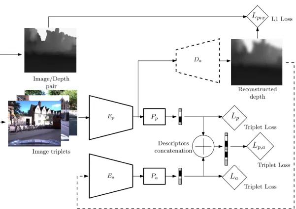
3.7 Image descriptors training with auxiliary depth data . . . 61
3.8 Joint vs individual optimization . . . 64
3.9 Data repartition . . . 65
3.10 Point cloud to depth map . . . 66
3.11 Examples of test images . . . 67
3.12 Importance of feature maps resolution with NetVLAD . . . 69
3.13 Comparison of descriptors pooling layer . . . 72
3.14 Comparison of our method versus competitors . . . 73
3.15 Comparison of top-1 retrieved images . . . 74
3.19 Examples of dense reflectance map . . . 80
3.20 Comparison of depth map and reflectance map as side information . . . . 82
3.21 Multi-modal training pipeline . . . 83
4.1 The two first steps of our relocalization pipeline . . . 87
4.2 Relative pose computation methods . . . 90
4.3 Influence of the number of kNN . . . 95
4.4 Refined position visualization – 1 . . . 97
4.5 Refined position visualization – 2 . . . 98
4.6 Refined position visualization – 3 . . . 99
4.7 Generated indoor depth maps . . . 103
2.1 Features in VBL . . . 14
2.2 Currently used datasets in VBL . . . 43
3.1 Contribution of the depth side information during training. . . 71
4.1 Point cloud alignment . . . 90
4.2 ICPL vs PnLP . . . 94
4.3 Results on 7 scenes dataset . . . 96
4.4 Results on 12 scenes dataset . . . 100
4.5 Supervised vs unsupervised model for localization . . . 102
4.6 Localization on outdoor scenes . . . 105
Je voudrais tout d’abord adresser mes remerciements à mes deux merveilleux directeurs de thèse. Merci Valérie de m’avoir considéré comme un vérita-ble collègue et merci pour la pleine confiance que tu m’as accordée. Quant à Cédric, merci de m’avoir guidé et soutenu à tout moment pendant ces trois années, parfois difficiles. Je souhaiterais remercier Désiré qui a toujours répondu présent et qui est devenu un peu plus qu’un encadrant de thèse pour moi.
Tout au long de ma thèse, j’ai eu la chance de partager mon temps entre deux laboratoires de recherche. Je voudrais remercier toute l’équipe Parisienne du Lastig, permanents, doctorants et stagiaires, pour les moments de sciences, de sports et de rire que j’ai pu partager avec vous. Je remercie également toute la famille Creusotine du laboratoire ImViA qui m’a accueilli chaleureusement pour mes cours séjours hors métropole et avec qui j’ai pu partager raclettes, barbecues et très bon vin de Bourgogne. J’ai une pensé toute particulière pour mon logeur, David, qui m’a accueilli chez lui dès mon premier séjour et sans qui mes voyages au Creusot aurait été plus terne (et plus chaud par moment).
Enfin, je souhaiterais remercier celle qui partage ma vie depuis plus dix ans, qui m’a donné l’énergie de tout donner pendant ces trois année et sans qui je ne pourrais pas être aussi fier du travail que j’ai accompli.
Visual-based Localization (VBL) consists in retrieving the location of a visual image within a known space. VBL is involved in several present-day practical applications, such as indoor and outdoor navigation, 3D reconstruction, etc. The main challenge in VBL comes from the fact that the visual input to lo-calize could have been taken at a different time than the reference database. Visual changes may occur on the observed environment during this period of time, especially for outdoor localization. Recent approaches use complemen-tary information in order to address these visually challenging localization scenarios, like geometric information or semantic information. However geo-metric or semantic information are not always available or can be costly to obtain. In order to get free of any extra modalities used to solve challenging localization scenarios, we propose to use a modality transfer model capable of reproducing the underlying scene geometry from a monocular image. At first, we cast the localization problem as a Content-based Image Retrieval (CBIR) problem and we train a CNN image descriptor with radiometry to dense geometry transfer as side training objective. Once trained, our system can be used on monocular images only to construct an expressive descriptor for localization in challenging conditions. Secondly, we introduce a new relo-calization pipeline to improve the lorelo-calization given by our initial lorelo-calization step. In a same manner as our global image descriptor, the relocalization is aided by the geometric information learned during an offline stage. The ex-tra geometric information is used to consex-train the final pose estimation of the query. Through comprehensive experiments, we demonstrate the effectiveness of our proposals for both indoor and outdoor localization.
La localisation basée vision consiste à déterminer l’emplacement d’une requête visuelle par rapport à un espace de référence connu. Le principal défi de la localisation visuelle réside dans le fait que la requête peut avoir été acquise à un moment différent de celui de la base de données. On pourra alors observer des changements visuels entre l’environnement actuel et celui de la base de référence, en particulier lors d’application de localisation en extérieur. Les approches récentes utilisent des informations complémentaires afin de répon-dre à ces scénarios de localisation visuellement ambigus, comme la géométrie
ou la sémantique. Cependant, ces modalités auxiliaires ne sont pas
tou-jours disponibles ou peuvent être coûteuses à obtenir. Afin de s’affranchir de l’utilisation d’une modalité supplémentaire pour faire face à ces scénarios de localisation difficiles, nous proposons d’utiliser un modèle de transfert de modalité capable de reproduire la géométrie d’une scène à partir d’une image monoculaire.
Dans un premier temps, nous présentons le problème de localisation comme un problème d’indexation d’images et nous entrainons un réseau de neurones convolutif pour la description globale d’image, en introduisant le transfert de modalité radiométrie vers géométrie comme objectif secondaire. Une fois entrainé, notre modèle peut être appliqué à des images monoculaires pour construire un descripteur efficace pour la localisation en conditions difficiles. Dans un second temps, nous introduisons une nouvelle méthode de raffine-ment de pose pour améliorer la localisation obtenue à la première étape. Comme pour le descripteur d’image global, la relocalisation est facilitée par les informations géométriques apprises lors d’une étape préalable. L’information géométrique supplémentaire est utilisée pour contraindre l’estimation finale
Introduction
This first chapter introduce the scientific environment of the thesis. We first present the global topic of long-term mapping followed by the introduction the overall project this thesis is part of. Then, we focus on the localization task, as it is the main topic of this research work.
1.1
Long-term mapping
Creating informative, accurate and detailed maps is a crucial step for many applications: pedestrian or vehicle navigation, data valuation, visualization, land or spatial planning, to name a few. Mobile mapping vehicles are able to collect and arrange large amount of data in order to create rich referential. However, these maps are fixed in time. Depending of the mapped area, the environment representation could be quickly outdated. Instead of recreating a completely new map, which is a costly operation, another solution is to locally update the map. This is what we called long-term mapping.
In order to include new data source to our initial representation, we need to located these information. In other words, we have to find the position of the up-to-date data according to the original map frame. Once we get a proper alignment between the two sources of data, we can update our main referential. In this thesis, we focus on the localization of visual data in the context of long-term mapping. Visual-based Localization (VBL) is not limited to the update of outdated referential and further applications are presented in the following. Thus, the core subject of this research is about localization of new visual data to a fixed, potentially outdated, map.
1.2
pLaTINUM project
This thesis is founded by the French Agence Nationale de la Recherche (ANR) and is part of the project named Cartographie Long Terme pour la Navigation Urbaine (pLaTINUM) (ANR-15-CE23-0010). pLaTINUM is a long-term mapping project composed of three parts: high quality multi-sources map creation, online visual-based urban navigation with user feedback and automatic map update for long-life usage. The first part is an offline mapping step from multi-modal data sources collected by a mobile mapping vehicle [31, 32, 206] that produces a high resolution textured mesh with radiometric, geometric and semantic information. Then, this map is used as a reference for an online visual navigation module. During the navigation, an agent sends visual feedback to the server in order to, in a third step, update the map if changes are detected between the reference map and the current observation. The city center of Rouen, in France, have been chosen to carry out the project experiments.
The subject of this thesis is the initial localization of the agent over the entire map before the start of the navigation. We detail in the next paragraphs the localization pipeline.
Summary of the map. The online localization task within the pLaTINUM project
consists of finding the position a visual data from the agent over a summarized version of the global map. To summarize the initial textured mesh, we render a set of radiometric (RGB), depth (D) and semantically labeled (L) spheres at meaningful location for cov-ering the entire area of possible navigation [252, 253, 254]. This representation contains all the modalities and most of the information from the original map while being lighter.
Initial agent query. In order to start the visually-guided navigation of the agent,
we have to find its absolute position on the mapped area. We assume that the agent is not equipped with any global localization equipment, such as GPS, and carry only an embedded device to acquire visual information. This is a regular assumption in urban area where global positional system can suffer from buildings obstruction (e.g. the urban canyon effect that affects the GPS signal). In order to be globally located, the agent sends from his capture device a visual request to a server. By visual request, we regardless denote: monocular image, video sequence, pair of stereo images, semantically annotated image or combination of these.
! VBL Embedded visual acquisition device Agent Visual request RGBDL Sphere Visual request or or or
Figure 1.1: The localization task within the pLaTINUM project: we are interested in the localization of an agent on a large outdoor urban scene. The map is succinctly described by a set of geo-referenced RGBDL spheres. The agent sends a visual request from a mobile device and we have to apply VBL methods to find the closest RGBDL sphere to the agent.
Localization in a graph of spheres. Once the map has been summarized and the
agent request received, the localization task can be compiled in this question: “which RGBDL spheres is located closest to the agent visual query?”. In order to answer this question, we have to develop methods that can handle potentially multi-modal requests and compare them to augmented spherical images.
We present in figure 1.1 the localization task considered within the pLaTINUM project.
1.3
Visual-based Localization with heterogeneous data
As introduced in the previous section, with the work of this thesis, we aim to solve a VBL problem. In the following, we introduce the general formulation of VBL and the
particularity of our problem: the heterogeneity of the visual data.
1.3.1
Visual-based Localization
VBL consists of retrieving the location of a visual request within a known space rep-resentation [38, 333]. For instance, recovering the pose (position + orientation) of a camera that took a given photography according to a set of geo-localized images or a 3D model is a simple illustration of such a localization system [128, 263]. VBL has been an increasingly dynamic research subject in the last decade. This recent gain of inter-est is due to the provision of large geo-localized images database, the multiplication of embedded visual acquisition system (e.g. camera on smart-phone) and the limitation of usual localization system in urban environment (e.g. GPS signal failure in cluttered environment). Aforementioned localization problem is involved in several present-day practical applications, such as GPS-like localization system [10], indoor [50] or outdoor navigation [36], 3D reconstruction, models and databases update, cultural heritage [29], consumer photography [106, 322] and augmented reality [96]. VBL is also used in robotics Simultaneous Localization and Mapping (SLAM) for Loop Closure Detection (LCD) [91] or to solve the «kidnapped robot» scenario [66].
VBL is a very challenging problem. The main obstacle comes from the fact that the visual request we aim to localize have been taken at a different time than the database. Visual changes may occur on the observed environment during this period of time, espe-cially if we target outdoor localization [168, 265]. For outdoor VBL, the appearance of the same scene observed from the query and the reference data can be different due to season changes [139], day-night cycle [227], weather conditions [228], mobile objects [295] (like cars or pedestrian) or urban evolution [251] (e.g. destruction or creation of buildings, change of street furniture). For the indoor case [290], visual changes can be generated by the modulation of the lightning [170], a rearrangement of a room, the people occu-pancy, etc. Differences in the request and the reference are also observable when the condition of the data acquisition differs. This can be due to the sensor architecture,
e.g. database and reference images acquired by different cameras [174, 184] or to
differ-ences on the pose of the agent that acquire the data, resulting on important view point changes [158, 174, 293, 299, 312].
It is very challenging to address these corner case with image-only VBL. However, the use of over information, such as the scene geometry [304, 329] or a semantic understanding of the image [321], can circumvent the limitation of mono-modal VBL.
1.3.2
Heterogeneous data in VBL
VBL involves comparing a visual data for which we seek the location, the query, to a geo-located reference database. In conventional pipeline, the query and the reference data are from the same modalities: e.g. an image and a collection of geo-referenced images [4, 6] or a segment of a 3D model with semantic information to a the fully seman-tized 3D model [272]. It exists plenty of VBL methods relying on a single-modality such as radiometric information [162, 234], geometric information [304, 329] or semantic in-formation [7] as well as methods based on multi-modal data: images and geometry [272], images and semantic [5], etc. The principal challenge comes when we observe an asym-metric representation of modalities between the request and the reference data. How to compare, or combine, data from different nature? This is a complex question, con-sequently, there is lack of method that benefit from heterogeneous data for the task of localization.
In this work, we are interested in VBL with heterogeneous data, i.e. the query and the reference data may not contain the same modalities. As mentioned in section 1.1, in the pLaTINUM project we are interested in localization of a heterogeneous visual query to a set of multi-modal geo-localized RGBDL spheres. That means we could encounter missing modalities or missing data within the queries comparing to the radiometric, depth and semantic modalities present in the reference data. We believe that heterogeneous and asymmetric data can be used wisely for the task of Visual-based Localization to overcome the limitation of single-modality systems. Therefore, within this thesis, we pursue research in this direction.
1.4
Thesis outlines
This thesis presents an original research work on the development of a new VBL method taking benefit from heterogeneous data.
An exhaustive review of existing VBL methods is presented in Chapter 2, with a special attention paid to data heterogeneity within these methods [220]. We first
enu-merate common processing among VBL methods and then we introduce the three classes of localization approaches. Open challenges as well as auxiliary data used to overcome limitation of visual-only systems are discussed thereafter.
Chap. 3 presents our learned global image descriptor augmented with auxiliary modal-ities and designed for the task of VBL in challenging conditions [223, 224]. We open the chapter with a brief review of descriptors for localization before introducing our global image feature extractor. The rest of the chapter is dedicated to exhaustive experiments on multiple challenging localization tasks.
In Chapter 4, we introduce a original image pose refinement step which uses missing geometric information to improve localization performances over our first method [221, 222]. Preliminary work and our final refinement pipeline are first presented. Then, we show the effectiveness of our method for localization in indoor environment before presenting furthers experiments on unsupervised auxiliary geometric learning for outdoor pose estimation.
Comprehensive study of
Visual-Based Localization methods
In this chapter, we present the Visual-based Localization (VBL) problem by firstly fo-cusing on the computer vision methods used in this area (sections 2.1-2.2) and, secondly, by regarding challenges in VBL (sections 2.3) and the nature of the data involved in the localization process (sections 2.4).
Topics addressed. We mainly focus on urban VBL as it represents the most studied
end-user application in literature. This can be explained by the fact that most of the related applications take place in non-rural environment. As an illustration, VBL as GPS pedestrian localization system should be used when the presence of buildings disrupt the satellite signal. Most of the augmented reality applications are also designed for indoor or urbanized environment. Similar reasoning can be employed with robotic applications. Nowadays principal concerns about robots are related to human assistance or supervision and autonomous vehicles. Those services occur in indoor and outdoor man-made areas, therefore the robot localization should be studied for these sites. The other aspect that invites researchers to focus on urban environment is that large datasets are mainly describing cities or road networks. Indeed, they are the most reachable places. With the exception of airborne and satellite imageries, that are abundant all over the globe. Regarding aerial images, use cases differ as the data are usually already well organized and accurately geo-referenced. Finally, interest in urban VBL is motivated by the high number of remaining open challenges: handling the large number of different object
classes present in the scene, dealing with visual obstruction and dynamic changes induced by significant temporal variation, etc.
As well as VBL presents a heterogeneity about its end-user applications, methods and data involved in the process of localizing an image are various. These methods are divided into three categories: Content-based Image Retrieval (CBIR) for image local-ization [2, 162, 233], 6 Degrees of Freedom (DoF) image pose estimation [33, 263] and hierarchical localization [257]. CBIR methods used in VBL slightly differ from classi-cal vision object-retrieval algorithm [278] on two points: the images in the query and the database represent scenes rather than objects (e.g. street view panorama, buildings images, indoor scenes) and the performance of such system is evaluated according to the precision rate rather than the recall rate (i.e. a perfect VBL system should recover in its top ranked candidates documents that display the exact location of the query). On the other hand, pose estimation methods aim to recover instantly the 6 DoF pose of the query data. Where Structure From Motion (SfM) or Simultaneous Localization and Mapping (SLAM) techniques provide a relative pose of a sequence of data, VBL tackles the problem of retrieving the absolute pose of a query data according to a known representation. Nevertheless, this representation could have been built thanks to SfM or SLAM mapping module. Finally, hierarchical localization, also known as coarse to fine localization, relative pose regression or localization cascade, can be seen as a combination of the two aforementioned methods. These methods can be divided into two steps: as a first instance, the research scope is reduced to obtain a initial coarse query pose, then, this result is refined by computing the correct transformation between the query location and the first guess pose.
When designing a VBL system, the type of method is not the only parameter to con-sider. As pointed out in [168], robustness to environment appearance changes over time is a main concern. Data involved in the process of localization also define specifications of the system, like area covered by the VBL method or precision of the regressed pose. Data types are various in VBL: visual data, geometric information (provided by RGB-D camera, LIDAR, etc.) and semantic clues. Combination of different data in VBL aims to overcome limitation of images-only based method.
Related works. VBL is a well studied topic, and many contributions propose overviews
most VBL applications. Moreover, we propose a comprehensive description of the three types of methods used in VBL, and highlight the benefits of the use of heterogeneous data in the context of localization in challenging scenarios. Zamir et al. [333] gather recent articles to draw a large panorama of VBL, corroborating the growing importance of this domain in current research. This assumption is comforted regarding the many tutorials (CVPR2014, CVPR2015, CVPR2017, ECCV2018 and ICCV2019), workshops (CVPR2015 and CVPR2019) and challenges (Google Landmark Retrieval 2018, Google Landmark Retrieval 2019, Visual Localization Benchmark) about the Visual Localization problem in high impact international conferences.
Visual Place Recognition is a roboticist problem, defined in the general sense in [168] as the visual ability of a human, an animal or a robot to recognize an already visited place. It is a main concern for navigation, especially when we consider topological mapping [88]. Despite the fact that Visual Place Recognition shares huge similarity with VBL, the two problems differ on three major points. On the one hand, visual-based localization and visual place recognition purposes differ; where Place Recognition decides if a given place have already been seen, VBL produces a pose of the visual acquisition system. This explains the difference in their respective pipeline. Visual place recognition is composed of three main components; the data processing module, the mapping module and the belief generation modules, while visual-based localization does not consider the mapping module. On the other hand, the study presented here aims to consider VBL in a more general context. Communities and applications of the reviewed methods belong to the Computer Vision community [258], as well as the Robotics [88] community. Finally, we consider heterogeneous visual data without restriction, including: raw colour and grey-scale images, depth images, point cloud and 3D models, as well as semantic information extracted from aforementioned data.
However, we advise reader to refer to the recent surveys related to Visual Place Recognition [88, 136, 168] in order to capture a global panorama of existing approaches involved in localization process with visual data.
The rest of this chapter is organized as follows: in section 2.1, we introduce data representations used in VBL followed by a description of the three family of localization
methods in section 2.2. Section 2.3 analyses the problem of challenging association across data variability and in section 2.4 we present an overview of the different types of data used in VBL. Finally, in section 2.5, common datasets and trends in VBL are discussed.
2.1
Data Representation
What is the best manner for representing visual data? This central question, present in various Computer Vision, Robotic and Photogrammetric applications, leads up to numerous answers. The data representation, termed features, should incorporate as much as possible discriminant information from the initial visual document and be fast to compute and compare. We present in this section representations used in VBL. Table 2.1 summarizes the following presented features.
2.1.1
Local Features
Local features are widely used in VBL and more generally in Computer Vision. Their description occurs at pixel level among a local neighborhood of several points in the image. The description through local features is two-step: firstly detect salient region (the extraction phase) and then characterize them according to their neighborhood (the description phase).
Point features. Several criteria are taken into account for the selection of point
fea-tures: scale, orientation and illumination invariance, as well as computational cost and descriptor vector dimension. A comprehensive list of local feature descriptors used in topological mapping in robotics can be found in Garcia-Fidalgo and Ortiz [88] sur-vey. Krajník et al. [139] explore in-deep many combination of detector/descriptor for the specific task of images matching across seasons. The most used point feature in VBL remains the Hessian-affine detector [185] combined with SIFT [166] descriptor. Im-portant contribution from Arandjelović and Zisserman [2] introduces RootSIFT which presents better results in matching step with minor overhead in computational load. SURF descriptors [26], light version of SIFT, are employed when real-time performance are required [64, 232, 285]. BRIEF descriptor rapidly computes a binary signature as-sociated to a keypoint using pixel intensity comparisons. The advantage of binary de-scriptors is that they can be compared efficiently using hamming distance. ORB
lo-cal feature [248] counter the lake of angular invariability of BRIEF descriptor by using orientation-aware feature detector from FAST [246]. Binary descriptors are widely used in VBL [81, 102, 138, 139, 184, 193].
Learned local features is a well studied topic [45, 70, 71, 74, 204, 213, 330]. Features are detected and described through Convolutional Neural Networks (CNN) trained for the task of similar features association. Schönberger et al. [271] propose a recent comparison of hand-crafted and learned feature proposed and show, amongst others, that traditional local features perform the best in some scenario related to VBL. In [257], authors use SuperPoint [71] as local features for images localization. D2-Net [74] have also been successfully applied to VBL. Features block extracted from a CNN can also serve as densely sampled local keypoints [324] (each keypoint is extracted along the depth of the features block). This dense extraction of local features have been successfully used for VBL in [221, 290]. Attention mechanism can be added to select discriminative areas from the dense features block, as illustrated with the weakly supervised DELF [201] system trained for large scale image localization.
Geometric features. Visual data can be described by primitive geometric shapes.
Despite the fact that geometric features are less compliant than point features, they in-clude semantically meaningful information. For example, vertical lines are convenient descriptor in urban environment to represent buildings [12, 189, 238]. On the basis of this observation, Hays and Efros [106] introduce line extraction in combination with others descriptors to describe images. Works in [52] introduce a semantic line-based de-scriptor. The vertical lines are extracted using Canny filtering and coded into VCLH (Vertical Corner Line Hypothesis) for meaningful building corners representation. Con-tour extraction have also been employed by Russell et al. [250] to recover the pose of an image in a site of archaeological excavations. In the work of Baatz et al. [16], authors assume that skyline will be present in the data and use it as a geometric features to describe mountain panoramas. Dehaze segmentation is used to extract the skyline that is thereafter encoded in a curve bin descriptor.
Considering 3D data, several works use three-dimensional geometric features like normal vectors [149] or planar surfaces [83]. Bansal and Daniilidis [23] use PointRay (i.e. a 3D vectors aligning with an edge) extracted from a Digital Elevation Model (DEM) to represent building corners. With recent progress of Deep Learning (DL) on 3D
point cloud processing [230], local learned point feature descriptors for localization have emerged. 3DMatch [336], 3DFeat-Net [329] and PPFNet [68] are a 3D point descriptor trained for the task of 3D points to 3D points registration and used to localize a local laser scan within a reference point cloud.
Point features with geometric relations. The lack of geometric consistency across
the whole image is a shortcoming associated with point features. Various contributions propose to overcome this limitation by adding local geometric information directly on the point descriptor [16, 117] or with the geometric association of numerous points [151, 163]. SIFT features contain scale and orientation information, that have been originally used in [117] through the Weak Geometry Consistency framework. Following the same idea, Baatz et al. [16] encode features relative pose in the image to perform geometric verification at matching time. Liu and Marlet [163] introduce a geometric descriptor called Virtual Line Descriptor (VLD) by connecting two local features with each other. The subsequent lines are used to reinforce the robustness of the matching process in VBL scenario [174]. Li et al. [151] propose a different pairwise geometric descriptor (PGM), showing great results on both urban and landscape scenes.
2.1.2
Global Features
Another description approach considers the image as a whole and produces one signature with high dimensionality (usually up to 4096 elements). Compared to local descriptors, global features are considered less robust in viewpoint changes, occlusion and local vari-ations in the image. However, they are computationally less intensive to extract and capture a comprehensive description of the visual data. With the recent progress on Ma-chine Learning (ML), a new class of very efficient global descriptor computed by CNN have emerged.
Hand-crafted features GIST descriptor introduced by Oliva and Torralba [202] is
the most used hand-crafted global descriptor in VBL [15, 106, 250]. Azzi et al. [15] use features in a cascade scheme to first narrow the search scope with global feature GIST and then select the good candidates with local features SIFT. The raw image can serve as a descriptor, with systematic resizing in order to obtain thumbnail [63, 106] (poten-tially augmented with depth information [92]). Simple descriptor computed through an
histogram upon various criteria (color, texture [106] or depth [199]) also provides a fast global information. Taking the image as a whole in a different representation space that is more discriminant for similarity research can also be considered as global description. For instance, Fourier Transform (FT) is used by Wan et al. [316].
Learned features Democratization of CNN in computer vision domain leads to
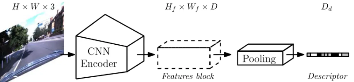
state-of-the-art techniques in image retrieval for urban scenes [6, 100, 132, 233]. Descriptors created through CNN are obtained using pooling mechanism on the computed features block [18]. We refer readers to section 3.1.1 for a detailed review on learned global image descriptor for the task of VBL.
Similar learned approaches have been recently used for 3D point cloud global descrip-tion [272, 304]. Schönberger et al. [272] combine 3D convoludescrip-tion on point cloud (the 3D information is stocked in volumetric grid of voxels) and an self-supervised deep auto-encoder and use the low dimensional latent representation computed by the network as global point cloud descriptor. In [304] the PointNet [230] network is associated to a differ-entiable Vector of Locally Aggregated Descriptors (VLAD) module, called NetVLAD [6], to train in a supervised manner a discriminative global feature for fast localization.
2.1.3
Patch features
Patch features consider region of interest in the image, it can be interpreted as a com-promise between local and global features. The patch could be manually extracted (with a fixed grid on an image, or a sliding window [67]) or automatically chosen in according to image saliency [178]. The discriminative HOG [67] descriptor has been used in VBL for capturing architectural cues of building and landmarks [14, 180, 189, 277]. In the work of [131, 200], MSER blob detector by Matas et al. [178] is used to extract visual information. Morago et al. [189] use a combination of local and patch features to describe repetitive shapes. Patch detector coupled with global descriptors are a common use in VBL, as illustrated in [100, 131, 287, 328]. Sünderhauf et al. [287] present promising works where the feature patches are automatically extracted with an edge boxes detec-tor [342]. Another CNN approach is introduced to perform VBL in [100], authors use a custom region proposal network [242] to extract regions of interest (ROI) and compute a deep representation of the ROI.
T able 2.1: F eatures in VBL: Sy n the ti c o v er v ie w o f fe a tur es us ed in V is ua l-B a se d L o ca li za ti o n. Name F eature typ e De tector Descriptor Used in VBL Pseudo C orners detector [188] P oin t ! " [188, 189] Hessian-a ffi ne [185] P oin t ! " [2, 4, 118, 151, 262] F AL oG [320] P oin t ! " [81] SI F T [166] P oin t !! [157, 200, 269, 281, 328, 331, 332] Ro o tS IF T [3 ] P o in t " ! [4, 184, 262, 300, 301] SU R F [26] P oin t !! [64, 151, 232, 281, 284, 309] OR B [2 4 8 ] P o in t !! [102] BR IE F [4 2 ] P o in t " ! [138, 139] BR IS K [1 4 4 ] P o in t !! [81, 184, 193] Learned descriptor P oin t " ! [45, 139, 213, 221, 290] Learned features P oin t !! [74, 201, 257] Lines [310] Geometric-2D ! " [12, 106, 189, 238] Skyline Geometric-2D !! [16, 55, 303] C on tours [43] Geometric-2D ! " [237, 250] VLD [163] Geometric-2D " ! [174] V C LH [52] Geometric-2D !! [52] PGM [151] Geometric-2D " ! [151] GI S T [2 0 2 ] Gl o b a l — ! [15, 106, 195, 250] Ti n y ima g es G lo b a l — ! [63, 92, 106] Histogram Global — ! [106, 199] F ouri er T ransform Global — ! [316] CN N G lo b a l — ! Refer to section 3.1.1 HO G [6 7 ] P a tc h " ! [14, 180, 189, 277] RPN [2 4 2 ] P a tc h ! " [100] Ed g e b o x es [3 4 2 ] P a tc h ! " [205, 287, 328] MS E R [1 7 8 ] B lo b ! " [131, 200] Normal v ector P oin t-3D ! " [83, 149] P o in tRa y [2 3 ] P o in t-3 D !! [23] Learned 3D p oin t descriptor P oin t-3D " ! [68, 329, 336] Planar surface P atc h-3D ! " [83] Spherical function [267] Global-3D — ! [169] Learned p oin t cloud descriptor Global-3D — ! [272, 304]
Online
O&ine
Visual query
Reference visual data + location
Simiarity research Data representation Candidates re-ranking Data representation + location Reference descriptors Query descriptor Ranked reference descriptors
Most relevant reference candidate8s)
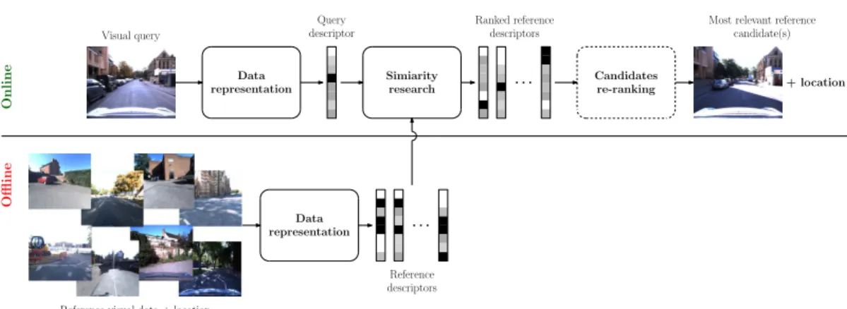
Figure 2.1: CBIR for localization: the location of a given request can be retrieved by comparing the query to a pool of geolocalized candidates. After the similarity research, the location associated to the top-ranked reference data is considered as the location of the query. Re-ranking of the reference data can be used in order to improve the relevance of the top-ranked candidates.
2.2
VBL methods
In the previous section, we have described data representation mostly used in VBL. The current section is dedicated to the method built on this representation to perform localization. As mentioned in the introduction, it exists three main family of methods:
• Content-based Image Retrieval (CBIR) for localization, • 6 DoF camera pose estimation,
• coarse to fine localization.
2.2.1
CBIR for localization
The aim of CBIR methods is to retrieve a set of data presents in the database that are similar to an input query. This is a problem related to instance retrieval [337]. As the visual data used in VBL are augmented with geospatial information (e.g. a geotag associated to an image), retrieving documents comparable to the input provides an information on the possible location of the query. This localization method is three-step: description of the visual data, similarity association across the description vectors previously extracted and possible candidates re-ranking. CBIR for localization pipeline is illustrate in figure 2.1.
Efficient data representation for localization
As one of our main contribution in this thesis targets the design of a new learned global image representation for long-term CBIR for localization, we do not detail data descrip-tion in this chapter. We refer reader to the first secdescrip-tion of Chapter 3, Sect. 3.1, for a comprehensive review of image representation suited for localization by indexing.
For the subsequent tasks of the localization process, we assume that we are able to produce low dimensional vectors to describe the visual data.
Similarity Research
The similarity research step involve evaluating the sameness between the request descrip-tor (i.e. the description vecdescrip-tor computed from the visual request we want to localize) and the reference descriptors. At the end of this step, we obtain a list of reference candidates, ranked accordingly to their similarity to the request.
Pre-processing. Dimension reduction of descriptor is often performed to reduce
match-ing time and memory footprint. The most used technique remains the Principal Com-ponents Analysis (PCA). PCA is applied on high dimension vector, e.g. features block extracted from CNN layers ([6, 100]). PCA has also been used to reduce the size of local features aggregated vectors [131, 301] or global descriptors [199]. Gaussian Ran-dom Projection is applied in [205, 287] and in a different work, binary locality-sensitive hashing [286] is used instead. To reinforce data consistency, whitening could be applied to final features before the similarity search [6, 99, 100, 115, 233, 298].
Similarity metric. For most methods, comparison between descriptors is a trivial
operation: it consists in a simple euclidean distance computation between vectors (with L2 norm or cosine similarity – if the vectors are unitary – as usually used function). Area correlation is another approach for computing data similarity. Simple forms of correlation like Sum of Squared Difference (SSD) or Sum of Absolute Difference (SAD) have been used in VBL to directly compare raw images [187, 225]. Wan et al. [316] use PC (Phase Correlation) on images described with FT (Fourier Transform) in order to be robust to shadow artifacts. In the work of [63], authors compare shadow invariant grey-scale images with Zero Mean Normalized Cross-Correlation (ZNCC).
Neareast Neighbor search. In some works, when the amount of data to compare remains acceptable, linear or brute-force retrieval procedure can be employed to retrieve the closest neighbors. Well-suited data structure (e.g. inverted-index or k-d-tree) can be used in order to speed-up the research process. Linear NN search is used in [6, 18, 100, 233, 286, 287, 331, 332], among others, where low-dimension global image descriptor (§2.1.2) are used to describe the data.
Exact nearest neighbors search becomes impracticable when the amount and/or di-mensionality of the features are too large. Authors then turn to approximate nearest neighbor search to trade efficiency for rapidity, thus accepting some errors in the re-trieved neighbors. Approximate matching involve hashing methods [95] and quantization frameworks [119, 200, 218]. Interested readers may see [317] for more details.
Several NN search algorithms are efficiently implemented in the FLANN library [194], and in the new Facebook FAISS library [124].
Machine Learning matching methods. Learning the distribution of the extracted
features is an alternative to aforementioned NN search methods.
Support Vector Machines (SVM) classifiers are used in numerous works [14, 44, 160, 180, 277] to cast the similarity research as a classification task. Cao and Snavely [44] initially cluster the database according to the resemblance of the images. On top of this graph of similar images, they trained SVM for each cluster and at query time oppose the input image to all classifiers. By selecting the data associated to the SVM reaching the higher score of classification, this approach permits to quickly retrieve a pool of similar images. In [14, 180] authors train linear classifiers on HOG descriptors to robustly retrieve similar images that present extreme appearances changes. Aubry et al. [14] take the advantages of Linear Discriminant Analysis (LDA) data representation in order to avoid expensive SVM training (like hard negative mining used in [131, 277]). Similarly, Kim et al. [131] train SVM classifier to predict the robustness of extracted descriptors. This improves the matching process and reduces the number of features to compare against the database.
Lu et al. [169] introduce a Multi-task Learning (MTL) layout designed for features similarity association. Works from Torralba et al. [302] and Ni et al. [199] present VBL methods that are able to localize an input query among a set of predefined places. Au-thors embedded the recognition process into probabilistic framework, Gaussian Mixture
Model (GMM) in [302] and epitome in [199], trained upon images representing different areas. Such paradigms allow an easy integration of additional knowledge (such as depth information [199]).
Graph matching. Stumm et al. [284] introduce an innovative method based on graph
matching. The visual vocabulary abstraction is employed and augmented with a graph of covisibility of the visual words in images. The graph is constructed as follows: nodes represent visual word detected in images and edges are created between two nodes if they are seen together in a same image. This formulation permits integrating geometric relations between the extracted features. Authors use a graph kernel for the similarity comparison among the query graph and the database [283, 285]. Notice that graph-based approaches are often employed when scenes are described by spatially organized semantic clues such as office furnitures [255] or street equipments [7].
Candidates re-ranking
Data can be processed after the similarity research to improve the final result. Post-processing methods are widely used to re-rank the candidate list, improving relevance of retrieved data.
Generic re-ranking. Query expansion is a post-process that re-query the database
after a first retrieval step to increase the recall rate [59, 60, 297]. However, increasing the recall rate is not the main concern of VBL indirect method [259]. Indeed, as exposed in the introduction, a perfect VBL indirect system should retrieve at first position the closest visual document present in the database. However, more suitable top ranked candidates in the list of retrieved data could benefit to a subsequent pose estimation step [281]. The VBL system presented by Cao and Snavely [44] increase the diversity of retrieved images by introducing a probabilistic re-ranking on the assumption that the first ranked candidate is not a good one and by maximizing the probability that the second one is. On the other hand, geometric consistency check is often used to reject wrong matching. Relative pose between the query and the database candidates is com-puted by considering homography or multiple-view transformation, and candidates that produce the most consistent pose are ranked up. Philbin et al. [218] democratize the use of spatial verification by introducing prior on the pose of the photography by assuming a
top-oriented view. Authors perform spatial check hierarchically to get more flexibility be-tween time computation and retrieval precision. The geometric transformation bebe-tween the query and the candidate is usually computed with minimal solver embedded in a Random Sample Consensus (RANSAC) [85]. There exists multiple alternatives to the classical RANSAC algorithm. PROSAC by [58], used in [72], prioritize specific features during the random selection step. We can also enumerate LO-RANSAC used in [218] and AC-RANSAC in [231, 232]. Novel method F-SORT presented by Chan et al. [53] show outstanding result both in term on matching quality and computation efficiency. Notice that these algorithms, beside improving the relevance of the retrieved candidates, can give information about the relative pose of the query. That is why numerous 6 DoF pose estimation methods, presented thereafter in Sect. 2.2.2, rely also on these techniques.
Specific VBL re-ranking. Unlike conventional methods of object-retrieval, indirect
VBL can benefit from geo-localization information associated to the documents present in the database. As discussed earlier, this information can be used to construct structured graph for the similarity search process [44, 299] or exploited to re-rank the candidates list [262, 331, 332]. Zamir and Shah [331] introduce this geographic re-ranking after a classical image-retrieval algorithm to quickly remove irrelevant candidates. Authors go one step further in [332] and embed the matching process within a Generalized Minimum Clique Graphs scheme to retrieve consistent candidates according to the GPS tag asso-ciated to the visual data. Sattler et al. [262] generalize the problem of visual burstiness introduced by [118] to a geographic level, introducing the concept of geometric bursti-ness. They improve the relevance of the ranked list of candidates using position and popularity meta-information of database images.
2.2.2
6 DoF pose estimation
At this point, we introduce camera pose estimation methods that instantly recover the exact 6 DoF pose of the query according to a known reference. Compared to CBIR approaches, 6 DoF pose estimation methods provide a more accurate query pose to the detriment of the area coverage. From this class of methods, we consider the two following approaches:
Online
O&ine
Visual query
Reference visual data
Features to points matching Features extraction Pose estimation from matches Structure from Motion Reference 3D model Local query features
6 DoF query pose Correspondences
between query and model
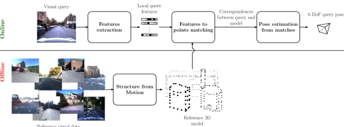
Figure 2.2: Structure-based VBL:reference data are used to construct a 3D model of the environment. During localization, the query is compared to this model to determine its 6-DoF pose.
Geometric methods: this class of methods, also known as structure-based methods,
performs the global localization of the query by establishing correspondences be-tween two-dimensional features extracted from a visual query and three-dimensional model of the environment (see figure 2.2).
Learned approaches: the second considered family of algorithms are methods that
learns a model to directly regress from an input visual data to its corresponding pose. We distinguish between local [276] and global [128] learned methods. Geometric methods
A widely represented family of VBL methods aims to regress the pose of a camera based on the analysis of a 3D point cloud reconstructed by SfM algorithms [191, 249, 270]. The principle of these methods is to establish 2D features to 3D points correspondences (F2P or 2D-3D in short terms). In a first step, three-dimensional representation of the environment is built thanks to many images. Triangulated points within this structure are associated to the local features (most of the time SIFT vectors [166]) extracted from all the images where the considered point is visible. At query time, local features from the query are matched against the set of pre-computed 3D points. Finally, 2D-3D correspondences permit a 6 DoF pose estimation of the acquisition system. Irschara et al. [111] introduce the first F2P method based on SfM environment representation. The overall pipeline of structured methods is presented in figure 2.2.
These methods have a lot in common with CBIR for localization approaches described in Section 2.2.1 as they share two major steps: feature extraction and data association. Yet, the use of a geometrically structured database introduces interesting elements not exploitable in a classical image-retrieval scheme [260].
Scalable localization. In [111], authors perform scalable VBL by registering the point
cloud into synthetic visual documents covering the entire model. Sattler et al. [258] con-sider the original features to points correspondences scheme by [111] and introduce a Vocabulary-based Prioritized Search (VPS) inspired by BoF matching method. Heisterk-laus et al. [108] introduce MPEG compression for visual document in order to speed-up the system. Works from [171, 184] tackle the problem of VBL embedded in a mobile device with limited memory storage and computational power. To achieve real-time per-formances, authors in [184] produce a very light 3D model to track the mobile camera in an urban environment. They send at regular interval key-frames to a server that is in charge of computing the global pose of the camera regarding a pre-produced point cloud. Aligning a light relative point cloud reconstructed with SfM to a bigger one have also been investigated in [169]. In the work described in [72], authors use the descriptor redundancy associated to 3D points to train random ferns on the top of each points. F2P matching time requirement is by the fact greatly reduced. Recent work by Feng et al. [81] reduce drastically the computational power requirement by considering fast point extractor and binary descriptors combined with an efficient similarity research. Authors show an order of magnitude in time reduction without any pose estimation performances deterioration.
Filtering wrong correspondences. Li et al. [153] reverse the conventional F2P
pro-cess by searching from the point cloud correspondences in the image (P2F), instead of matching features from the image to points. This formulation causes an overhead in computation but is correctly handled by considering a compressed version of the SfM model and by implementing end-conditions and rejection cases in their algorithm. In work from [154], authors augment the P2F matching with hypothesis of co-occurrence of 3D points present in a close neighborhood. Based on similar observation, Sattler et al. [261] consider visibility graph to reject wrong matchings. Svarm et al. [288] con-sider the problem of VBL with F2P matching as a combinatorial optimization problem
and design a fast outliers rejection scheme. This promising work have been improved through [289, 335] contributions. In [141], authors extend the image registration prob-lem to video registration. Temporal redundancy obtained from the visual flux facilitates the 2D-3D matching by adding smoothness constraints. Semantic filtering is also used to enforce matching consistency between features and points [295]. In [161], the pro-posed method achieve the best localization result on commonly used datasets without any prior assumptions on the query pose by introducing global co-visibility constraints with Markov network.
Pose estimation. F2P (as well as P2F) provides correspondences between 2D pixels
and 3D points. Properly redefined by Hartley and Zisserman [105], perspective-n-point (PnP) formulation is the most common tool to recover the absolute camera pose according to a point cloud reconstructed by SfM.
Embedded in a random consensus scheme (see §2.2.1), six correspondences between the image and the 3D model are sufficient to retrieve the pose, if we have no information about the intrinsic parameters of the camera [72, 108, 153, 153]. This formulation is known as P6P and can be solved with Direct Linear Transformation (DLT [105]).
In particular cases, three correspondences between the image and the model are sufficient (P3P pose computation problem). Especially, the pose estimation problem can be reduced to a P3P formulation if the intrinsic parameters of the camera are known [111, 184], or if 3 or more DoF are fixed [232, 288, 289, 335]. In those particular cases, P3P solvers Kneip and Furgale [133] are mostly used to recover the pose.
In [282], authors are interested in privacy preserving personal information in augmented-reality consumer application. They argues that SfM point cloud can be targeted by inversion attack to recover the original state of the mapped scene. That is why they propose a 3D Line Cloud scene representation to replace the original point cloud and use 3D points to 3D lines association to recover the pose of a query image.
Learned methods
The last class of 6-DoF pose estimation methods cast VBL as a machine learning problem. A model is trained with geolocalized visual data in order to be able to predict the 6-DoF pose of an unknown visual request. Key components of learned methods are presented in figure 2.3. If the scene geometry is completely known, local method can
Online
O&ine
Visual query
Reference visual data + poses
Trained model
Reference 3D model
6 DoF query pose Trained model Data representation Data representation Model training
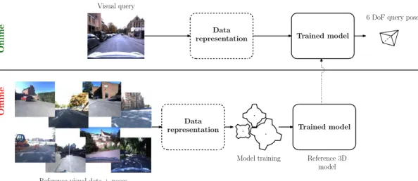
Figure 2.3: Learned method for VBL: a model is trained with geolocalized data in order to regress the right pose of a visual request. Once trained, the model is used to predict the pose of a unknown query. The data can be preprocessed (dotted blocks) before the evaluation by the model.
Figure 2.4: Scene coordinates repesentation: local learned-based VBL method rely on scene coordinates representation of the environment to retrieve the 6-DoF pose of a query. Model on the right is colorized according to the xyz position of the 3D points mapped in RGB color space. Fig-ure from [33].
be applied [276] (i.e. the data involved in the learning processes are local feature or raw pixels). Otherwise, the method is global and entire images are used as input to the model [128].
Local methods. First introduced by Shotton et al. [276], local learned method for
VBL are based on the scene coordinates representation of the environment. Scene co-ordinates representation associates to each pixel of an image its 3-dimension coordinate in a global scene frame. It means that we requires both image 6-DoF pose as well as scene geometry (e.g. depth map associated to the image) to create a scene coordinates representation. See figure 2.4 for a colorized example of scene coordinates representation. During training, we minimize the error between predicted 3D coordinates of each pixel
of a training set of images with the ground truth scene coordinates. Once the model is trained, we can use it to predict dense 3D coordinates at each pixel position of a new image. Finally, these 2D-3D correspondences (2D position of pixels’ image and predicted 3D coordinates) are used to compute the 6-DoF of the query image. Similar algorithm as the ones used for structure-based methods (see section 2.2.2), embedded in a random consensus, are used in order to compute the query pose. This class of method is compact but not scalable: it requires to train one model by scene.
In the initial works by Shotton et al. [276], authors use a regression forest to learn the mapping from pixel to 3D scene coordinates. At query time, a handful of pixels from a depth camera frame are processed into the regression forest. This method is fast and pre-cise and can be used on texture-less data. However, the depth information associated to each pixel is needed at test time. This initial method have been improved in [104], where authors take in consideration several candidates for the final pose regression obtained by multiple trained predictors. Valentin et al. [307] introduce mixture of Gaussian to rep-resent the uncertainty associated with the regression forest prediction and significantly improve the 6 DoF estimation by embedding this information within the full camera pose regression step. The regression forest have been replaced by Neural Network (NN) in [177], bringing slightly better result at the cost of computational overhead. Meng et al. [182] consider only RGB images at query time. The loss in precision is compensated by a post pose refinement step based on nearest neighbors search with sparse extracted SIFT features (like in structured approaches, see section 2.2.2).
Duong et al. [73] introduce a patch-based approaches where area centered on keypoints extracted from standard image detector are used instead of raw pixels. During training, they use a CNN to predict 3D-coordinate from the extracted image patches. In major work of Brachmann and Rother [33], the complete image is used as input to a fully-CNN. The model predict a dense scene coordinates image and the authors perform end-to-end training regarding the final pose prediction thanks to a differentiable version of RANSAC (DSAC [35]). They obtain convening results using only images and they show that their method can be applied even if we do not know the full geometry of the scene. In [152], a new loss function is introduced to stabilize the training of fully-CNN for dense scene coordinates prediction.
To address the scene-dependent limitation of classical methods, Glocker et al. [97] design a system based on regression ferns to quickly associate an RGB-D image to a
binary feature. Ferns produce descriptor according to randomly initialized binary rules, and a look up table is maintained to directly associated image signature with 3D pose in the scene. Presented system is less precise that the one presented by Shotton et al. [276] but has the advantages of not relying on a heavy pre-processing step (i.e. the spawning of the regression forest). Along the same line, promising work of Cavallari et al. [49, 50] propose to quickly adapt a pre-trained regression forest to a new scene. This method permit to recover the pose of a RGB-D camera frame, more precisely than Glocker et al. [96, 97], without the costly step of complete regression forest training. Recent work in [51] applied a variant of the precedent method with fully-CNN architecture of [33] instead of regression forest. They fill coordinates reservoir at the end of a pretrained model with information about a new scene to quickly obtain a precise localization system. In a different manner in [80], authors propose to use multiple models distributed all over the area of interest. At query time, they use a Mixture of Export (MoE) for weighting predictions of each model, embedded in a differentiable RANSAC [34, 35] for end-to-end training.
Global methods. Introduced in 2015 by Kendall et al. [128], the first global learned
method, PoseNet, consists of a fine-tuned CNN for the task of 6-DoF pose regression. The network is trained upon a set of paired image/pose and directly regress the 6-DoF pose of a camera from an image. The pose obtained through this method is not as accurate as the pose obtained with geometric or local method [33, 81] but provides great tolerance to changes in scale and appearance. Compared to scene coordinates-based methods [152, 276], CNN seems more appropriate to handle large environment and does not rely on depth information.
Recent improvement have been proposed by the original authors [126] to integrate an uncertainty estimation in the regression process. Liu et al. [164] consider this CNN architecture with only depth map information, acquirement with active depth sensor, for recovering the pose of a camera in complete obscurity. The work by Walch et al. [314] present a combination of a PoseNet [128] with a Long Short-term Memory (LSTM) units plugged at the output of the network in order to encode stronger spatial information from the image. This combination slightly improves the precision of the system. Authors of [122] propose a new method to gather supplementary image/pose pairs for the network training. They generate artificial images from a dense point cloud model obtained by SfM
thanks to a rendering software. Computer graphics shaders effects are added on some rendered views for simulating various illuminations. In [229], the view synthesis procedure is extended to real images thank to the known geometry of the scene. Contreras and Mayol-Cuevas [62] exploit this CNN architecture in order to create a fixed size map that can be improved by adding new trajectories. Authors were able to reduce the original size of the CNN by factor of three while maintaining similar localization performances on indoor scenes. Recent contribution [127] investigate new loss-functions for the training phase of the CNN, by adding constraints from multi-view geometry standards [105]. MapNet [37] introduces relative constraint between two consecutive images in order to train the regression network with unannotated data. For this training setup, the relative pose between two images is computed by a Visual Odometry (VO) algorithm [79, 86]. In a similar manner, VLocNet [306] benefits from relative pose information between consecutive frames by relying on two different networks with shared representation: one for absolute pose regression and the over one for relative pose estimation between two images. In a subsequent work [236, 305], authors show how multitask [129, 135, 334] learning can improve the pose estimation.
Although Posenet-like method has the advantages of being lightweight and relies on only-images, Sattler et al. [266] show that performances of such methods are less precise than CBIR-based pose estimation (section 2.2.1). They demonstrate that learned pose regression method are more likely to average the pose of the training examples [300] rather that computing a real pose based on geometric constraints. Another disadvantage of Posenet-like methods, and more generally of learned methods, rely on the fact that a different model has to be trained for each new scene.
Differently, recent work from Weyand et al. [322] consider the localization problem as a classification task. They perform a worldwide training on 126M images categorized into 26k places across the globe. According to a given image a CNN, named PlaNet, estimates the most likely location of the query over the split map. Localization of multiples photos taken from a common album can be performed by augmenting the original network with a LSTM layer. Vo et al. [313] push further the study of such a neural network and conclude that the features extracted from layers of PlaNet are more discriminative to determine the location of an input image that the CNN classifier itself. By extracting features instead of using a classification algorithm, their contribution is closer to the original CBIR world-wide localization method IM2GPS [106] (see section 2.2.1). Seo


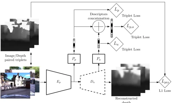
![Figure 3.6: Hallucination network for image descriptors learning: we train an hallucination network, inspired from [110], for the task of global image description](https://thumb-eu.123doks.com/thumbv2/123doknet/14536857.724198/80.892.174.773.169.583/figure-hallucination-network-descriptors-learning-hallucination-inspired-description.webp)